Islamic archaeology is a discipline with enormous potential, due to the survival of both standing remains and written records. However, perhaps because of the traditional focus of archaeologists on Pharaonic remains, fieldwork in Egypt has lagged badly behind that taking place in other Arab countries. Egypt's distinct cultural traditions make reliance upon theories of urban development founded on evidence from other provinces problematic. In order to address this issue, a survey was undertaken in April 2004 of the ruined city of Tinnis, located on an island in the brackish Lake Manzala on the north-eastern fringes of the Nile Delta. This project was generously supported by the British Academy, the Fondation Max Van Berchem, the Barakat Trust and the Wainwright Fund for Near Eastern Archaeology.
The Tell Tinnis Archaeological Project began in 1998 with the aim of recording the few standing remains on the island of Tinnis, some seven kilometres south-west of Port Said (Reference GascoigneGascoigne 2003). However, it was not until April 2004 that a complete survey was undertaken. The aim of the work has been to record as efficiently as possible the largely featureless mounds of rubble that characterise the site, and to extract the maximum amount of information from what remains without undertaking the sort of large-scale excavations necessary to uncover a ground plan of the town. The survey results will allow the formulation of an informed site management strategy for future investigation.
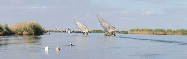
Lake Manzala and the reed beds of Tinnis island (photograph by Sarah Parcak).

Tinnis was, in its day, one of the richest manufacturing centres in the mediaeval Middle East. It is first mentioned by the classical writer John Cassian, who visited the site in the late fourth century and commented upon its desolate location (Conferences book 11.1). Despite this, the island was a prominent trading post. It was also a bishopric and important Christian centre, and the site of a battle during the Arab conquest of Egypt in 642 (Reference MunierMunier 1943; Reference BallBall 1942; Reference ButlerButler 1902, repr. 1978). After this event, and apparently as a result of deliberate policy by the new regime, industrial activity in the town began to flourish, in particular the manufacture of textiles; a number of mediaeval historical accounts of the town survive to supplement information gleaned from archaeological investigation (for example Nasir-i Khosrau, who visited Tinnis in 1047; Ibn Basssam al-Tinnisi, writing around the twelfth century; al-Maqrizi, 1364-1442). Weaving was regulated by the government, being organised into workshops and heavily taxed: cloth from Tinnis could sell for a great deal of money, some types being interwoven with gold threads. This prosperous situation, though, was undermined both by the decline of the textile industry (perhaps due to reduced demand and overtaxation) and by the increasing insecurity of the area. The town was attacked and damaged on several occasions in the eleventh and early twelfth centuries, and finally evacuated by order of the Ayyubid sultan al-Malik al-Kamil in 1227, though the island nonetheless continued in use as a trading base until at least the fifteenth century.
The post-abandonment history of the town is very much responsible for the difficult character of the site. The enclosure walls and citadel were razed to prevent their being used by the Crusaders or other hostile forces. Subsequently, the site has been repeatedly dug over by locals looking for reusable building materials, since there is no local source of stone. A mid-nineteenth century visitor recorded that archaeological material from the island was dumped into one of the narrow mouths of the Nile to impede the passage of maritime raiders (Reference WilkinsonWilkinson 1843). In addition, the wet and salty conditions hasten the deterioration of standing structures, and pose significant conservation problems for modern archaeologists. The area enclosed by the ruined town wall is today around 93 hectares, though the edges of the intra-mural area are lost in the lake on the south and west sides of the island. Furthermore, the extra-mural mounds, clearly once extensive, are now mainly beneath the lake or flattened into sandy strands by constant washing of water; the banks of the island are fringed by thick reed beds.
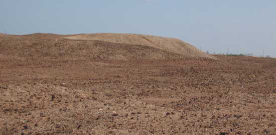
One of the highest mounds on the island, perhaps the location of the citadel.

A cistern of the later type, the roof having collapsed, built up against a smaller example of an earlier tank, at a lower datum with some of its roof still intact.

The survey of the mound carried out in April 2004 was done using Leica 500 series differential GPS equipment with sub-centimetre accuracy, by Helen Fenwick of Hull University. One of the advantages of this equipment is its ability to record precise spot height readings. The limits of surviving remains, the line of the enclosure walls, the location of previous excavations and regular contour heights were all recorded: in total more than 10 000 points were taken. The resulting map sheds light on the structure of the town, indicating that the enclosure wall had horseshoe towers at regular 35-metre intervals; in some areas traces of what might be gates are identifiable. At the north-west corner of the site are remains of a harbour channel fortified by a round tower, and other canals run into the town from the west and south. The site grid and several fixed points were added to the map; by these means future work on the island can be incorporated into the existing survey.
In order to glean the maximum information from currently accessible archaeology, the project included an architectural survey of a number of cisterns uncovered during excavations by the Egyptian Antiquities Service since 1978. Although these excavations were not scientifically controlled, they nonetheless provide a useful opportunity to undertake archaeological recording of sub-surface features; the size and general state of the site is such that the destruction of stratigraphy in a limited area is not really a major concern. It is notable that almost all the revealed structures would have been below the original mediaeval ground level; the prospects for recovering evidence for the layout of the buildings and streets above are very poor. However, cisterns are extremely numerous, an unsurprising state of affairs given the peculiar situation of the town. Surrounded by salt water, the islanders relied on the annual Nile flood, during which the lake became potable; water was collected and stored on the island for use throughout the rest of the year. An examination of the channels and tanks in the main Egyptian excavations by architect Nicholas Warner revealed two phases of construction. Examples of the earlier type of cistern date to around the ninth century and are at a lower datum than later types, many having their roofs intact. They are characterised by multiple cross- or barrel-vaults, the interior surfaces being coated with a distinctive pink lime mortar. The later period constructions are identifiable by the use of a grey lime mortar with a high percentage of fly ash used in both the masonry and a first plaster layer internally - a layer of pink plaster was subsequently applied over this as the final finish. The identification of these phases of building has allowed a study of the diachronic development of the town's water system. The configuration and layout of the cisterns and their connecting channels may indicate that, while the early foundations were endowed by the authorities as public facilities, in later times the control of access to water rested increasingly in private hands.
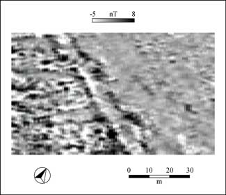
Tinnis is a largely featureless site and, in the absence of visible surface archaeology, clearly it must be a high priority to find some means other than excavation of assessing the buried remains. To this end, we were keen to make trials of geo-physical techniques, and an area of 5.5 hectares was surveyed by Claire Stephens of GSB Prospection using a Geoscan Research FM256 fluxgate gradiometer. The ground conditions on Tinnis are unfortunately not ideal for geophysical survey, being generally very uneven and covered in a dense scatter of fired brick and slag debris, and the results were variable in quality. Across about half of the area, little in the way of structures or other features was discernable. However, on the west bank of the south canal, a complex more than 50 metres across shows up as a clear anomaly, as do the quays of the waterfront and what may be a bridge across the canal. In a sector on the north-east corner of the site, gradiometry revealed that the enclosure wall is a great double structure, with what may be smaller interconnecting walls running across the central 'walkway' and buildings built up against the interior face.
Magnetometry survey of the town enclosure wall, revealing two horseshoe towers.

A tiny gold disc bearing the shehada and the name of the Fatimid caliph Al-Hakim, found on the surface of the site (photograph by Gillian Pyke).

The creation of a ceramic typology, including material both from the surface and from exposed sections, was initiated in 1998, and continued in 2004. Two small sondages designed to investigate the town's fortifications produced a large quantity of sherds and small finds, which were analysed and drawn. Part of a slate palette and a broken flint knife blade from one of these trenches may be predynastic in date. The remaining material was late Roman and Islamic, with in particular glazed wares and imported porcelain-type vessels surviving well in the damp conditions, but the stratigraphy was in general very disturbed. The pottery corpus will shed light on the town's extensive trading links, in addition to contributing to our currently rather limited knowledge of Islamic ceramics in Egypt.
Overall, the survey has completed the initial mapping of the site, in addition to investigating various ways in which work on the island might proceed. Following our season, a team from the Institut Français d'Archéologie Orientale in Cairo is planning to undertake excavations on the island in 2005 under the direction of Jean-Michel Mouton of Lyon University. We can thus hope to see further information coming from Tinnis in the near future.