Introduction
Measurement of surface melting is of interest for studies of glacier dynamics and for monitoring climatic changes in polar regions. Downward percolation of meltwater from the firn surface, followed by refreezing at colder depths, transports heat downward at a much greater rate than thermal conduction and diffusion. Reference MercerMercer (1978) and Reference Stuiver, Denton, Hughes, Fastook, Denton and HughesStuiver and others (1981) suggested that enhancement of this melt-freeze process during a “greenhouse” warming could be sufficient to raise the ice shelves to the pressure-melting point throughout, leading to their disintegration. Reference Paterson and Van LoonPaterson (1984) considered this process in more detail and concluded that the projected greenhouse warming would not be sufficient to induce disintegration; however, he noted the need for more quantitative data on the meteorological conditions and melting on the shelves.
Under current climatic conditions, surface temperatures remain below freezing over most of the Antarctic ice sheet throughout the year. Some surface melting extends inland from the Ross Ice Shelf onto the ice sheet of Marie Byrd Land (Reference GiovinettoGiovinetto, 1964; Reference Alley and BentleyAlley and Bentley, 1988). However, in most places on the ice sheet, the dry-snow line lies only a few tens of kilometers inland from the coast or from an ice-shelf grounding line (Reference GiovinettoGiovinetto, 1964). Extensive surface melting usually occurs each year on many of the ice shelves, specifically those in the Antarctic Peninsula, those adjacent to the Amundsen and Bellingshausen Seas, and those along the East Antarctic coast, including the Amery Ice Shelf. Of the major ice shelves, the Ross Ice Shelf has occasional surface melting, but the Filchner-Ronne Ice Shelf lies almost entirely within the dry-snow line (Reference GiovinettoGiovinetto, 1964).
Early measurements of the microwave emission from snow cover on land showed large increases in the microwave brightness temperature (Tb) as the moisture content in the snow increased above zero (Reference EdgertonEdgerton and others, 1971). Passive-microwave images of the polar regions, from the ESMR (Electrically Scanning Microwave Radiometer) on the Nimbus-5 satellite, showed large increases in Tb during summer on the percolation zone of Greenland and on the Antarctic ice shelves where surface melting usually occurs (Reference ZwallyZwally and Gloersen, 1977). Also, the data showed marked variations in Tb on daily time scales, indicating that the emissivity was changing rapidly in response to changes in the melt-freeze conditions of the surface. Such rapid changes had also been observed in snowpacks during diurnal melt-freeze cycles (Reference EdgertonEdgerton and others, 1971).
Theoretical calculations of the microwave emission from snow and firn by Reference Chang and PChang and others (1975) showed that small amounts of liquid water on the surface of the ice particles significantly changed their dielectric properties, reduced their radiative scattering and increased the microwave emission from the media. Reference Davis, J and ChangDavis and others (1987) compared that model with an alternate model, in which the water is assumed to occur in small menisci between ice spheres. In the models and measurements, the microwave emission drops upon refreezing, because the ability of the ice particles to scatter radiation emitted from deeper in the snow or firn is re-established. In addition, during melt-freeze cycles, the average size of the snow grains increases, which increases the radiative scattering and lowers the Tb when the firn is frozen. Therefore, dry firn that has undergone prior melting tends to have a lower Tb than firn that remains continuously dry.
Passive-microwave maps of the ice sheets were first made with data from the ESMR passive-microwave imager on Nimbus-5, which was launched in December 1972 and continued to operate for several years after Nimbus-7 was launched in 1978. However, not all ESMR data were usable, and degradation of the sensor was most serious after 1976. The SMMR (Scanning Multichannel Microwave Radiometer) on the Nimbus-7 satellite collected good-quality data every other day from November 1978 until August 1987 (Reference Gloersen, Campbell, Cavalieri, Comiso, Parkinson and ZwallyGloersen and others, 1992). The next section describes the objective criteria chosen to extract a passive-microwave surfacemelt index from satellite Tb data. The derived surface-melt index describes the spatial and temporal variability of the surface melting.
Physical Basis for Passive-Microwave Surface-Melt Index
As previously noted, the onset of melting produces a marked rise in Tb that is caused by moisture in the near-surface firn. However, the amount of rise depends on the difference between the emissivity, ∈, of wet firn and the e of dry firn. The emissivity of dry firn at 1.5 cm microwave wavelength varies from about 0.65 to 0.85 (e.g. Reference Zwally and PZwally, 1977; Reference Zwally and PZwally and Gloersen, 1977) and is strongly dependent on the firn grain-size. The emissivity of wet firn is about 0.9 and tends to be independent of the grain-size. Therefore, the Tb of dry firn has widely different values in different firn zones, but the Tb of wet firn is nearly the same in all zones. Using the equation Tb = ∈Tp (where Tp is the physical temperature), the maximum value of Tb corresponding to a wet-firn emissivity of 0.9 is about 245 K. Therefore, the rise in Tb with melting ranges from about 70 to 10 deg, corresponding to the 0.65–0.85 range in emissivity of dry firn.
Consequently, some possible criteria, which could be useful for detection of melting in microwave brightness temperatures, are: (1) a rise of Tb above a fixed threshold, (2) a rise of Tb by a fixed amount above the expected local average summer value in the absence of melting, and (3) a rise of Tb by a fixed amount above the local mean annual Tb. Thresholds for the second and third criteria would vary spatially, depending mainly on the microwave emissivity of the dry firn, and would allow a more sensitive detection of melt, as discussed below.
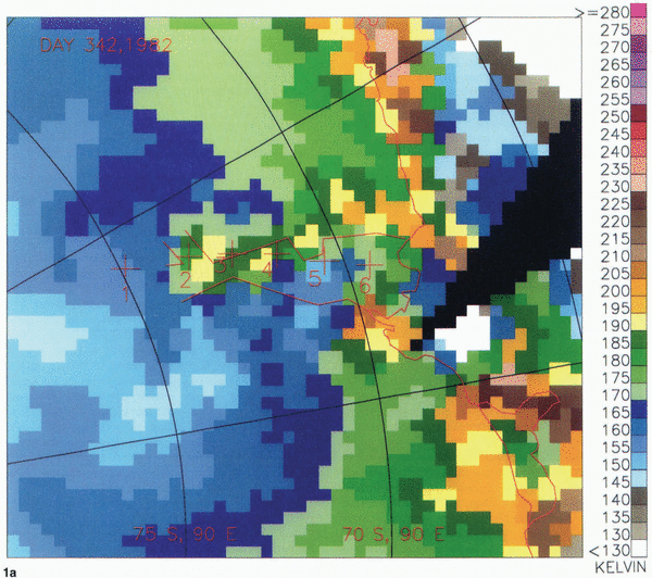
Figure 1 shows Tb, at 1.5 cm wavelength and horizontal polarization, on the Amery Ice Shelf and the surrounding ice sheet during the onset of melting in December 1982. The time interval between each of the three maps is 10 d. The field-of-view of the SMMR instrument is 55 km at 1.5 cm wavelength, and the data are mapped into approximately 30 km square pixels, which are visible in the figure. Therefore, each data pixel represents the average firn conditions over about 3000 km2, even though the data are mapped into 900 km2 pixels. Although the emissivities of wet firn at horizontal and vertical polarizations are nearly equal, the emissivity of dry firn at horizontal polarization is significantly lower than at vertical polarization. Therefore, horizontal polarization is used, because the increase in Tb with melting is larger at horizontal than at vertical polarization.
Microwave brightness temperature from Nimbus-7 SMMR on the Amery Ice Shelf and vicinity on (a) 8 December (day 342),(b) 18 December (day 352),(c) 28 December (day 362) 1982. On day 352, when surface melting is indicated at points 4 and 6, the melt patterns may be affected by heating by katabatic winds on Lambert Glacier (points 3 and 4) and Kreitser Glacier and adjacent glaciers (southeastward from point 6). On day 362, surface melting is indicated over the entire ice shelf and inland on the ice sheet to about 1800 m elevation.


For the three scenes shown in Figure 1, the Tb is given in Table 1 at six locations labeled in the figure: on the ice sheet (point 1), upper Lambert Glacier (point 2), lower Lambert Glacier (point 3), the grounding line (point 4), central Amery Ice Shelf (point 5) and lower Amery Ice Shelf at 100 km from the shelf front (point 6). On Julian day 342 (8 December 1982), there is no indication of melting in the Tb map. On Julian day 352, the Tb increased by 18 deg or more at locations 2–6 (upper Lambert Glacier to lower Amery Ice Shelf), with the largest increases at points 4 and 6 but no increase at location 1 (on the ice sheet). Although the 2¾ increases observed at all locations 2–6 suggest some melting on day 352, the smaller increases of about 20 deg at locations 2 and 5 are not clear indications of melting, because the winter to summer change in Tb (due to the seasonal change in physical temperature of the firn in the absence of melting) is also about 20 deg. By Julian day 362, locations 2–6 have increases of about 40 deg or more, clearly indicating a rise caused by melting.
Brightness temperatures at six locations extending inland from the front of the Amery Ice Shelf on three days in December 1982

On day 362, marked increases are evident over the entire ice shelf, appearing somewhat larger on the eastern side of the shelf. Also, large Tb increases indicative of melting are observed on the ice sheet surrounding the ice shelf to an elevation of about 1800 m. As shown in the following analysis for 9 years, the extension of surface melting as far inland as location 2 (upper Lambert Glacier), as observed during day 362 of 1982, was unusual. During the summer of 1982/83, melting in other parts of Antarctica was also above average.
As previously noted, a sensitive criterion for melting would be the rise of Tb by a fixed amount above the average summer Tb value expected in the absence of melting. Such a value could be determined by approximating the annual Tb cycle at each location and estimating the expected average value during the summer. The time series of Tb from 1978 to 1987 at the six locations on or near the Amery Ice Shelf (Fig. 1) are shown in Figure 2. Also shown are the mean annual brightness temperatures, (Tb), averaged over the 9 years for each location. It can be seen that (Tb) typically lies about 15±5 deg below the average summer Tb that would be expected in the absence of melting. Therefore, a rise of Tb by a fixed amount above (Tb) is used as a criterion for melting, because it is nearly equivalent to the rise above the non-melting summer value and is much simpler to calculate from the data. Consequently, the threshold value of Tb taken to signify melting is defined as Tc, and is chosen to be equal to (Tb) plus 30 K.
The time series of Th 1978–87 at six locations on the Amery Ice Shelf and its vicinity (cf. Fig. 1). Also shown are the mean annual brightness temperatures, (Tb), averaged over the 9 years. Tc is the threshold value of Tb taken to signify melting, and is chosen to be equal to (Tb) plus 30 K.

The value of Tc equal to (Tb) plus 30 K, as shown in Figure 2, captures most of the apparent melting events and is sufficiently large to minimize false counts. The marked rise in Tb above Tc is clearly evident on the ice shelf at locations 5 and 6. A Tb rise above Tc rarely occurs at location 2 on upper Lambert Glacier, occurs briefly in about half of the years at location 3 on lower Lambert Glacier, occurs every year except 1981/82 at the grounding line and occurs every year at the two ice-shelf locations. No evidence of melting is seen in the Tb measured at location 1, on the ice sheet.
Increasing surface melting along the line from Lambert Glacier to the grounding line and toward the ice-shelf front is indicated by the increasingly longer duration of the rise of Tb above Tc. The decreasing (Tb) along this line also suggests that the firn has been subject to an increasing amount of surface melting toward the front. As noted previously, the process of melting and freezing increases the grain-size, which lowers the Tb of the refrozen firn. Consequently, the Tb signal associated with the onset of melting is stronger in areas where prior melting was greater. In some cases of unusually strong summer melting, such as location 6 in 1983, the Tb falls at the end of the melting season to a value that is lower than in other years.
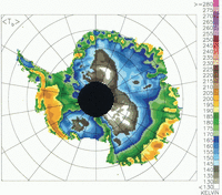
The rise in Tb with melting would also be large in areas of normally dry firn with low accumulation rates and large grain-sizes near the surface, such as location 1. The (Tb) is very low at ice-sheet location 1, because of the larger grain-sizes in the firn that are characteristic of dry-firn areas with low accumulation rates (Reference ZwallyZwally, 1977). The annual Tb cycle of about 20 K at location 1 is due to the annual cycle of the physical temperature. The e is about 0.63. In the dry-firn zones, e typically increases toward the coast, mainly due to the smaller grain-sizes where the accumulation rates are higher. The higher Tb on Lambert Glacier, compared to location 1 for example, suggests less microwave scattering in the firn, smaller grain-sizes, and presumably a higher accumulation rate on the glacier compared to the ice sheet upstream from the glacier. The Tb also increases toward the coast due to the higher Tp at lower elevations, but this is typically a secondary effect. In areas of normally dry firn that have high accumulations and small grain-sizes near the surface, such as northeastern Marie Byrd Land (cf. Fig. 3), the rise in Tb with melting would be small and more difficult to detect.
Map of mean annual brightness temperatures, (Tb), averaged over the B years from Nimbus-7 SMMR. The low (Tb) on the Amery Ice Shelf, and on ice shelves in the Antarctic Peninsula and elsewhere, is caused by radiative scattering by the larger snow grains formed during summer melting. Other patterns are discussed in the text.

The increase of Tb as a function of the amount of moisture in the firn is also of interest. Measurements of snowpack on land showed that Tb rose to a maximum (saturation) value with moisture contents of only a few per cent in a thin surface layer. However, there is disagreement as to whether the moisture content required for saturation is in the range of about 10–20% or 2–5%. Reference EdgertonEdgerton and others (1971) showed that Tb at 0.8 cm microwave wavelength reached a maximum with about 15% moisture content, and at 2.2 cm wavelength reached a maximum with about 22% moisture content. Reference Stiles and UlabyStiles and Ulaby (1980) showed Tb at 0.8 cm wavelength reaching a maximum at a lower moisture content of only about 1.5%, whereas Reference Davis, J and ChangDavis and others (1987) showed a maximum at about 4%. Reference Davis, J and ChangDavis and others (1987) also noted that the thickness of the wet layer grew to 3 cm as the moisture content reached 6%. Furthermore, Reference EdgertonEdgerton and others (1971) noted that T b remained high and did not appear to decrease as the moisture content increased enough to create a slush-like consistency.
For the purposes of a climate index, the actual value of the moisture content is not especially important. However, the characteristic of a monotonic increase of Tb to a maximum without a subsequent decrease is very important, because it eliminates ambiguities between very wet and less wet firn. If, however, the moisture is not free to percolate and water collects in ponds or puddles, the Tb would be lowered by an amount that can be estimated. Where ponding occurs, such as in areas of the Amery Ice Shelf (personal communication from I. Allison), the observed Tb would be lowered in proportion to the area of the sensor field-of-view covered by ponds. Since the Tb of liquid water at 1.5 cm is about 130 K, the Tb of an area with 20% ponds and 80% wet firn at Tb of 245 K would be about 222 K, for example. Since the lowest Tc on the Amery Ice Shelf is less than about 200 K in the regions of intense melting, ponding would have to cover about 40% of the area of wet firn to reduce the observed Tb below Tc. Therefore, in most places the area of ponded water in wet firn is unlikely to be sufficient to cause failure to indicate melting. In areas where the Tb’ is above Tc, but below the 245 K characteristic of wet firn, the probable causes are either a mixture of melting and non-melting firn within the field-of-view, or an averaging of measurements from periods of melting and non-melting surface conditions, as well as the possibility of some ponding.
Calculation of Surface-Melt Index
The duration and extent of melting are described by a surface-melt index (in units of duration times area), which is calculated by adding the areas of the pixels in the brightness-temperature maps where melting occurs, over selected regions and periods of time. For each 30 km × 30 km pixel in the daily maps, Tb increases of more than Tc = 30 deg above the annual-mean brightness temperature, (Tb), are taken to indicate melting, as discussed in the previous section. The map of (Tb) is shown in Figure 3. Each occurrence of melting was counted twice, because data were only collected by SMMR every other day. The consequent error caused by this adjustment for missing data should be very small, except possibly in regions of very infrequent and short-duration melting.
The duration of melting at each location (number of days per pixel) is shown in Figure 4 for 1982/83 and 1983/ 84 for the months of December and January. Most melting occurs in December and January. Also shown are the six regions selected for calculation of the melt index: (1) the Antarctic Peninsula, (2) the Filchner-Ronne Ice Shelf region, (3) the Dronning Maud Land coast, (4) the East Antarctic coast including the Amery, West and Shackleton Ice Shelves, (5) the Wilkes Land coast, and (6) the Ross Ice Shelf region and the West Antarctic coast west of 90° W. The melting is unusually large in the summer of 1982/83 and smaller than average in the summer of 1983/84. For 1982/83, the index for all of Antarctica is 35.8 × 10⁶ d km2 for November-February and 34.8 × 10⁶ d km2 for December and January. Therefore, the daily average area with surface melting is 0.56 × 10⁶ km2 during December and January, or about 4% of the continental area. In 1983/84, the corresponding values are 17.0 × 10⁶ d km2 for November-February and 15.0 × 10⁶ d km2 for December and January, with a daily average of 0.24 × 10⁶ km2 during December and January, or 2% of the continental area.
Local surface melting (days per pixel) for (a) 1982/83, which is a summer with unusually high surface melting, and (b) 1983/84, which is a summer with below-average surface melting. Analysis regions are outlined. The surface melting shown on the Ross Ice Shelf in 1982/83 is unusual.


In both summers 1982/83 and 1983/84, some parts of the Larsen Ice Shelf, the northern Antarctic Peninsula, Alexander Island, and the ice shelves surrounding Alexander Island had surface melting throughout December and January. During the 1982/83 summer, above-average melting occurred in the Dronning Maud Land, Amery Ice Shelf, and Antarctic Peninsula regions, and an unusually large area of melting occurred on the Ross Ice Shelf.
Correlation of Surface-Melt Index and Temperature
The relationship between higher values of the surface-melt index and the occurrence of temperatures above and near the melting point is examined, by comparing regional melt indices with monthly-average tempera-tures at selected stations (Reference Jones and LimbertJones and Limbert, 1988). The monthly-average station temperatures should represent the regional temperatures, (Ts) which affect the regional surface melting and therefore the calculated melt index. In contrast, daily temperatures should be more closely related to local and short-term variations in melting. The derived relationship between melt index and temperature shows how melting increases with increasing summer temperature, and demonstrates the validity of the melt index.
The Australian Davis Station at 68.6° S, 78° E is only about 250 km northeast of the locations on the Amery Ice Shelf where the most extensive melting in the region occurs. The surface-melt index in Figure 5 clearly increases as summer temperatures increase. The linear fit between the melt index and monthly-average station temperature indicates a melt-index increase by 0.67 × 10⁶ d km2 per degree of temperature rise. It also implies that the summer melting is negligible when the average monthly temperature at Davis Station is less than −2.3°C.
Correlations between the calculated melt indices and monthly-average station temperatures (cf. Table 2), December and January 1978–88, for (a) Davis Station and the Amery Ice Shelf region(b) Syowa Station and Dronning Maud Land region.(c) Rothera Point and the Antarctic Peninsula region.(d) Casey Station and Wilkes Land region.


At the smaller values of the melt index, the relationship to temperature appears to be linear. However, the increase of the melt index as a function of temperature is greater for December than it is for January, when the index value is generally largest. At larger values of the index, a non-linear relation should be expected, because a maximum in the melt index must be reached when the entire area experiences melting every day. Although melting over all of this particular region is extremely unlikely, melting of much of the area below an elevation of several hundred meters is very likely during December and January. Such melting on the Amery Ice Shelf is shown in Figure 4a by the pixels with more than 30 d of surface melting. For increasingly higher temperatures, additional increases in melt area would occur at a much slower rate, because the inland spread of melting is retarded by the large surface slopes of the ice sheet above several hundred meters elevation.
Furthermore, inter-annual departures from a linear relation, as suggested by the scatter in the data, might also be expected, because melting is inherently a non-linear function occurring only above a threshold temperature. For example, for a month with unusually cold temperatures during part of the month, and with a significant period of melting, the average temperature might be below normal while the amount of melting is above normal.
Some of the scatter may also be caused by variations in the spatial extent of heating that is caused by katabatic winds. Melt patterns that appear to be related to katabatic winds are illustrated in some of the daily Tb maps. For example, on Julian day 352 of 1982 (Fig. 1b), melting is indicated on the northern part of the Amery Ice Shelf, extending southeastward from point 6 to Kreitser Glacier (and adjacent outflow glaciers) and onto the ice sheet to about 1000 m elevation. Similar melting is indicated on lower Lambert Glacier down to the grounding line (points 3 and 4), but not on the middle part of the ice shelf at point 5. Since katabatic winds are channeled by the topography on such outlet glaciers, the corresponding patterns of melting on day 352 are likely to be affected by katabatic-wind heating of the surface. In contrast, melting associated with warm synoptic-scale meteorological conditions should be more uniform over larger areas at the same surface elevation (e.g. Julian day 362 in Figure 1c).
Similar relationships between the melt index and summer temperatures are found in the other regions (Fig. 5b-d; Table 2), except in the Ross and Filchner-Ronne Ice Shelf regions where melting is too infrequent. The linear correlation coefficients between the melt indices and the monthly-average station temperatures are greater than 0.7, except in the Wilkes Land region where the melting is small. In the Amery Ice Shelf region, the relationships are nearly the same for Davis and Mawson Stations, but the colder temperatures at Mirny are reflected in the lower value of the threshold temperature (the monthly-average station temperature above which regional surface melting usually occurs). In the Antarctic Peninsula region, the slope of the index-temperature relation is about twice as large as for the Amery Ice Shelf and Dronning Maud Land regions. In the Wilkes Land region, it is only about one-tenth as large. Therefore, for each degree of increase in Antarctic summer temperatures, about as much area of melting is added in the Antarctic Peninsula as in the rest of Antarctica.
Relation between regional surface-melt indices and monthly-average station temperatures (Ts). R is the linear correlation coefficient

Regional and Temporal Variations in Surface-Melt Index
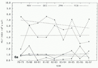
The calculated surface-melt index for each of the six selected regions and their sum are plotted in Figure 6, for the nine summers from 1978/79 to 1986/87, for the months of November, December, January, and February. As noted before, most Antarctic surface melting occurs during December and January. In most cases, the index indicates more melt in January. The indices for November and February are typically about 5–10% as large as for the other two summer months.
Calculated melt indices for nine summers for the months of November, December, January, and February for six regions and overall: (a) the Antarctic Peninsula, (b) Filchner-Ronne Ice Shelf, (c) The Dronning Maud Land coast, (d) The East Antarctic coast including the Amery, West and Shackleton Ice Shelves, (e) The Wilkes Land coast, (f) The Ross Ice Shelf region and the West Antarctic coast west of 90° W, and (g) Overall.


The largest amount of melting occurs in the Antarctic Peninsula region, followed by the Dronning Maud Land and Amery Ice Shelf regions with nearly equal amounts of melting. In some years, the amount of melting in the Ross Ice Shelf region is as large as in the Dronning Maud Land and Amery Ice Shelf regions, but during several of the summers almost no melting is observed in the Ross Ice Shelf region. A lesser amount of melting occurs in the Wilkes Land region, but it is more consistent from year to year. In the Filchner-Ronne region, the melt index is very small (<0.3 × 10⁶ d km2 per month), but this region is the only one that shows an increase in the melt index during the nine summers.
The melt index for all of Antarctica in Figure 6g shows a decreasing trend on the basis of the linear fit for the months of November (−0.04 × 10⁶ d km2 year−1), December (−0.26 × 10⁶ d km2year−1) and January (−0.39 × 10⁶ d km2year−1). A small increase is indicated for the month of February (0.11 × 10⁶ d km2year−1). The 9 year average values of the melt index are 1.12 × 10⁶ d km2 for November, 8.56 × 10⁶ d km2 for December, 13.00 × 10⁶ d km for January, 1.32 × 10⁶ d km2 for February and 24.00 × 10⁶d km2 for the entire summer. The overall melt index for Antarctica for the entire summer (Fig. 7) shows a decrease of −0.58 × 10⁶d km2year−1, or −2.4% per year. However, the inter-annual variability is very large. The year-to-year fluctuation is three times as large as the 9 year decrease inferred from the linear fit. Also, the peak-to-peak difference, between the largest overall melt index of 35.8 × 10⁶ d km2 in 1982/83 and the smallest of 15.3 × 10⁶ d km2 in 1985/86, is 20.5 × 10⁶ d km2, or 85% of the average value.
Calculated melt indices for nine summers, November-February 1978–87, for all of the Antarctic. Linear fit shows a tendency for decreased melting, but the trend is not significant because of the large inter-annual variability.

Conclusions
The physical basis for the observation of surface melting on ice sheets by satellites is the marked increase in the passive-microwave brightness temperature of firn that occurs with small amounts of moisture in the top few centimeters. A surface-melt index is derived and calculated for Antarctica for nine summers from 1978/79 to 1986/87. Comparison between the calculated regional-melt indices and selected-station air temperatures shows definitive correlations. The correlations suggest that the surface melting in Antarctica increases about 3.5 × 10⁶ d km2 per degree of summer temperature increase. Also, surface melting usually occurs when the monthly average temperature is above about −4 to −2°C.
The 9 year average melt index calculated for Antarctica is 24 × 106 d km2. Antarctic surface melting was most intensive in the 1982/83 summer (35.8 × 10⁶ d km2) and least intensive in the 1985/86 summer (15.3 × 10⁶ d km2). Most melting occurs during December and January, with more in January. Linear-least-squares slopes are mostly negative (i.e. decreased surface melting in later years), but the significance of any inferred trend is undetermined because of the large inter-annual variability. In most cases, the melt index alternates from low to high from one year to the next, suggesting a biannual oscillation in the melt conditions during this period.
The accuracy of references in the text and in this list is the responsibility of the authors, to whom queries should be addressed.