


Impact statement
The research presented a collaboration between coastal scientists, Indigenous researchers, archaeologists and the community from Aotearoa/New Zealand. This study integrates archaeology, geomorphology and mātauranga (a type of Indigenous knowledge) to investigate a sandy coastal barrier system. The findings reveal the presence of archaeological sites that are culturally important to local Māori communities, located in exposed frontages of coastal dunes that have been eroding at 45 cm/year over the past 80 years. The inclusion of mātauranga, offering ecological and genealogical knowledge, was crucial to this study by providing information about the archaeological site at risk of being eroded away. The archaeological site was dated to be 200 years old, indicating that the coast had not been any further eroded than the current position during that period (or otherwise the site would not exist). This study demonstrates how investigated and dated archaeological sites can provide temporal markers that enhance and extend in time our understanding of coastal landform development. This research demonstrates the effectiveness of integrating western science approaches and Indigenous approaches, offering a framework that can be adapted globally for coastal studies. This is crucial in the context of rising sea levels and increased storm activity, which threaten both natural and cultural heritage worldwide. The approach also underscores the importance of including Indigenous perspectives and knowledge systems in scientific research, which can lead to a more nuanced scientific understanding of geomorphic systems.
Study highlights
-
1. Approaches from archaeology, geomorphology and mātauranga are braided to improve our understanding of the selected coastal barrier.
-
2. The coastal barrier is undergoing erosion that has exposed cultural sites within the dune that demonstrate the barrier is in the most eroded state it has been within the past 224 to 270 years.
-
3. This study highlights the importance of weaving different knowledge systems to improve understanding and preserve coastal landscapes.
Introduction
There is a barrier of language and meaning between science and traditional knowledge, different ways of knowing, different ways of communicating. (Kimmerer Reference Kimmerer2013: 189)
Coastal barrier systems are influenced by coastal sediment budgets, relative sea-level changes, wind speed, storm-induced erosion, vegetation cover and a variety of anthropogenic pressures (e.g., FitzGerald and Buynevich, Reference FitzGerald and Buynevich2009; Little et al., Reference Little, Spencer, Schuttelaars, Millward and Elliott2017; Woodroffe, Reference Woodroffe2002; Woodroffe et al., Reference Woodroffe, Cowell and Dickson2011). Coastal sand barrier systems are valuable archives of climate and sea level, storm erosion, aggradation and time-varying sand supply information (Otvos, Reference Otvos2020). Barrier systems evolve in three principal modes: (1) prograding, (2) transgressing/retrograding and (3) aggrading (Galloway and Hobday, Reference Galloway and Hobday1980). Prograded barriers record depositional history laterally and, therefore, retain the highest preservation potential of any coastal system developed within the Holocene (Caseldine and Turney, Reference Caseldine and Turney2010; Dougherty et al., Reference Dougherty, Choi and Dosseto2016; Little et al., Reference Little, Spencer, Schuttelaars, Millward and Elliott2017). Understanding the historical development of barrier systems is important for understanding how coastlines will respond to sea-level rise (SLR; Mariotti and Hein, Reference Mariotti and Hein2022; Kennedy et al., Reference Kennedy, David, Fresløv, Rogers, Mullett, Birkett-Rees, Bowman, Faulkner, Land and Corporation2023, Williams and Gutierrez Reference Williams, Gutierrez and Williams2009), providing insights into coastal hazard risk for communities (Hinkel et al., Reference Hinkel, Aerts, Brown, Jiménez, Lincke, Nicholls, Scussolini, Sanchez-Arcilla, Vafeidis and Addo2018; Rowland and Ulm Reference Rowland and Ulm2012; Rowland et al., Reference Rowland, Ulm and Roe2014); and informing the preservation of archaeological and cultural heritage in the face of future SLR (Carmichael et al., Reference Carmichael, Wilson, Namarnyilk, Nadji, Brockwell, Webb, Hunter and Bird2018; Rowland, Reference Rowland2008; Rowland and Ulm, Reference Rowland and Ulm2012).
Archaeological sites provide invaluable temporal and spatial information that illuminates the timing of anthropogenic effects on landforms (see Rivera-Collazo et al., Reference Rivera-Collazo, Ramos-Vélez, Rodríguez-Delgado and Cantú2021). Archaeological data have proven to be a valuable resource for geomorphological interpretation and have been incorporated into larger multidisciplinary studies to reconstruct the geomorphological evolution of landforms (Mason, Reference Mason1993). For example, Caporizzo et al. (Reference Caporizzo, Gracia, Aucelli, Barbero, Martín-Puertas, Lagóstena, Ruiz, Alonso, Mattei, Galán-Ruffoni and López-Ramírez2021) utilised the position of Phoenician settlements and the remains of the La Martela Punic harbour, which were buried by fluvial sediments, to reconstruct the geomorphological evolution of the Northern Bay of Cádiz since the mid-Holocene. Other researchers have examined archaeological sites to evaluate present-day landforms and determine whether they have been affected by historical anthropogenic activities (Rivera-Collazo et al., Reference Rivera-Collazo, Winter, Scholz, Mangini, Miller, Kushnir and Black2015). Archaeological sites, assemblages and artefacts have also been used as indicators of ancient sea levels, as discussed in recent reviews (Aucelli et al., Reference Aucelli, Cinque, Mattei and Pappone2016). Furthermore, Aucelli et al. (Reference Aucelli, Cinque, Mattei and Pappone2016) used four geo-archaeological sites on the Sorrento Peninsula coast (Italy), where the submerged ruins of Roman buildings enabled the reconstruction of ancient positions of both past sea level and coastlines. Other studies have used archaeological sites as spatiotemporal reference points to provide radiocarbon data for coastal change research. For example, coastal landforms often contain evidence of human occupation, and radiometric dating of such evidence can contribute to the reconstruction of palaeo-coastlines and sea levels (Mason, Reference Mason1993; Nichol et al., Reference Nichol, Lian and Carter2002).
A common element between geomorphological and archaeological investigations is the need to obtain chronological constraints. It is common in coastal geomorphology, for instance, to combine morphostratigraphic techniques, such as ground-penetrating radar, coring and airborne light detection and ranging (LiDAR) with radiometric methods, such as optically stimulated luminescence dating, to describe barrier development over millennial to interdecadal timescales (e.g., Oliver et al., Reference Oliver, Tamura, Hudson and Woodroffe2017). Similarly, in archaeological investigations, for example, radiocarbon dating of well-developed palaeosols in contrast to thin humic layers within coastal barrier sequences has been useful for constraining the timing of dune accretion and mobility over several thousand years (Bampton et al., Reference Bampton, Kelley, Kelley, Jones and Bigelow2017; Gorczyńska et al., Reference Gorczyńska, Stéphan, Pailler, Nicolas, Pénaud, David, Vidal and Le Gall2023; Sommerville et al., Reference Sommerville, Hansom, Housley and Sanderson2007). However, few studies have attempted to utilise oral histories of Indigenous communities alongside geomorphological and archaeological methods (Roberts et al., Reference Roberts, Westell, Fairhead, Lopez and Murray2023; Westell et al., Reference Westell, Roberts and McCullough2023).
The Western scientific community often disregards Indigenous knowledge because of the perception that it is mythical and fantastical, and hence not reliable, lacking accuracy and precision (King and Goff, Reference King and Goff2010). However, in Aotearoa/New Zealand, Indigenous knowledge – mātauranga – is not only an accurate archive of oral history, landscape evolution and natural events but has also been shown to influence and improve contemporary research (Hikuroa, Reference Hikuroa2017; King et al., Reference King, Goff and Skipper2007; Jones et al., Reference Jones, Hikuroa, Gregory and Ihaka-McLeod2020; Mercier, Reference Mercier2018). Furthermore, many oral histories are empirically derived and tested through time, and hence scientific, but explained from a Māori worldview (Hikuroa, Reference Hikuroa2017). Early use of oral histories sometimes suffered from loss of contextual framework, misrepresentation of data or a tendency to accept insights only if confirmed by science (e.g., Bedford, Reference Bedford1996; Davidson, Reference Davidson1967). Hence, archaeologists and Māori scholars have not always agreed to the use of oral histories as textual sources to confirm the accuracy of ethnographic descriptions (e.g., Anderson et al., Reference Anderson, Binney and Harris2014; Campbell, Reference Campbell, Clark, Leach and O’Connor2008; O’Regan, Reference O’Regan2016). Critics caution that combining methods might cause conflicts between Western science (e.g., archaeology/geomorphology) and Māori scholars. One issue might be a failure to recognise the significance of whakapapa (genealogy) (Hikuroa, Reference Hikuroa2017; Marshall, Reference Marshall2021; McIvor et al., Reference McIvor, Roa and Waitoki2024). Whakapapa, as emphasised by Royal (Reference Royal1992) and Roberts (Reference Roberts2012), is a fundamental element that underpins tribal histories and imbues meaning into human actions and understanding within the Māori community. According to Tau (Reference Tau1999), whakapapa is used to encode events relative to their ancestors rather than assigning them to a specific point in time. Tau (Reference Tau1999) also pointed out that applying chronology to genealogical time is akin to historicising a past that is not linear. Instead, whakapapa is a narrative construct to map the natural world and its phenomena and serves as a mental framework for comprehending places. Tau (Reference Tau1999) emphasised the importance of layering Māori knowledge and referencing places, ancestors and key figures as memory cues for retaining vital information. Wehi et al. (Reference Wehi, Whaanga, Watene and Steeves2020) also emphasise the importance of layering Māori knowledge and referencing places, ancestors and key figures as memory cues for retaining vital information. Thus, mātauranga has a distinct ordering system that may lead to misunderstandings if stories and their elements are interpreted using a different knowledge system rather than within the context of ancestry and cultural experience (King and Goff, Reference King and Goff2010). This differs from the geomorphological and archaeological perspectives of time, which consider the diachronic past, present and future.
Research that seeks to braid Māori and Western scientific approaches requires active collaboration with Māori researchers and the ancestral community, who provide and contextualise oral history. In undertaking this kind of work, the “braided method” is a theoretical framework that enables the braiding of Indigenous and Western knowledge systems to examine the same physical environment, although from distinct ontological viewpoints (Tengö et al., Reference Tengö, Brondizio, Elmqvist, Malmer and Spierenburg2014; Macfarlane et al., Reference Macfarlane, Macfarlane, Gillon, Macfarlane, Macfarlane and Webber2015). According to Atalay (Reference Atalay2020), a braided knowledge approach should acknowledge and credit knowledge carriers, follow cultural protocols and allow refusals.
In this article, we aim to braid archaeological, geomorphological and mātauranga methods and knowledge to investigate the late Holocene development, stabilisation and migration of a selected coastal barrier system in northern Aotearoa/New Zealand. Few previous studies have attempted to combine these knowledge systems in Aotearoa/New Zealand (see Barber and Higham., Reference Barber and Higham2021; King and Goff, Reference King and Goff2010; McFadgen, Reference McFadgen2007; McFadgen and Goff, Reference McFadgen and Goff2007; McIvor et al., Reference McIvor, Roa and Waitoki2024, and in Australia see Roberts et al., Reference Roberts, Westell, Fairhead, Lopez and Murray2023; Westell et al., Reference Westell, Roberts and McCullough2023). We utilise archaeological data from middenFootnote 2 sites preserved in sand dunes, ecological information obtained from oral histories documented in mātauranga, and geomorphological analyses of barrier topography to examine barrier development from pre-contact Māori occupation to the modern day. Hence, our objectives are to (1) appropriately apply the braided approach in the context of sand barrier evolution and (2) critically evaluate the extent to which the braided approach adds value rather than using a single approach in isolation.
Methodology
The methodology of this article embraces a pluralistic approach, braiding techniques from archaeology, geomorphology and mātauranga. In Aotearoa/New Zealand, the migration of Polynesian voyagers and their settlements, as well as the development of the Māori culture and later the arrival of Western colonial powers, have left a lasting impact that has resulted in numerous archaeological sites along the coastline. The initial Māori settlement occurred at approximately 700 B.P. (Anderson, Reference Anderson2016a, Reference Anderson2016b; Bunbury et al., Reference Bunbury, Petchey and Bickler2022; Walter et al., Reference Walter, Buckley, Jacomb and Matisoo-Smith2017). Archaeological sites are primarily located near the coast because of human reliance on coastal resources and transportation by waka (canoe) (Jones et al., Reference Jones, Dickson, Ford, Hikuroa and Ryan2023).
Patuharakeke is tangata whenua (local people) of the Poupouwhenua/Marsden Point area, which includes Te Akau/Bream Bay (Figure 1). This is demonstrated through ahi ka roa (continuous occupation), nohoanga (dwelling place), customary practices, kōrero (story), pūrākau (tales), tuku whenua (gifted land), marriage, ancestry, raupatu (confiscated), customary tohu or signs (e.g., landmarks, tuahu and kohatu mauri on the land). The naming of water systems and land features is one way that tangata whenua demonstrate the depth and closeness of their long traditional relationship with the site and surrounding area. The harbour, and ranges and peaks that surround it, are named in pepeha (a set form of words) and tribal whakataukī (significant saying) and waiata (song). These provide further rich descriptors of the relationship of Patuharakeke with the Poupouwhenua/Marsden Point area and their historical ties to all resources within the area. In contemporary times, Patuharakeke is represented through entities such as the Patuharakeke Te Iwi Trust, and their Pou Taiao (Environmental) Unit. The Taiao Unit focuses on exercising kaitiakitanga (guardianship), revitalising and integrating tikanga (protocols) and mātauranga-a-hapū (community-specific mātauranga) practices into the restoration of the local environment. The key aspirations for Patuharakeke are the local taitamariki (children) who whakapapa to Patuharakeke. As the Taiao Unit journey through their mahi (work), they engage taitamariki in culturally informed educational programmes that encourage interest in the environment while passing down their mātauranga to ensure the next generation can support environmental regeneration through a mix of traditional and Western practices.
Location of Poupouwhenua / Marsden pt Point where Te Akau / Bream Bay is located in Te Tai Tokerau (Northland), B) drone image showing vegetated foredune on Te Akau beach and located location of midden and C) location of midden in the context of Te Akau/Bream Bay. In red are locations discussed in the paper.

Te Akau is an east-facing open-ocean foredune beach situated on a prograded Holocene barrier system (Figure 1). Vegetation within the dune system today is dominated by Pōhuehue (Muehlenbeckia complexa), Toetoe (Austroderia spp), Wīwī (Cyperaceae spp) and Pampas (Cortaderia selloana) and characterised by a series of large hummocky dune ridges (average height of ~7 m) that transition into a higher foredune complex in the seaward direction (~14 m height). Recent storm events, such as the tropical Cyclones Hale and Gabrielle (January and February 2023, respectively), caused significant erosion to the foredune, further eroding the exposed midden (Figure 2). The ridges in the prograded Holocene barrier system generally become progressively younger towards the sea, overlaying transgressive estuarine deposits (Dougherty, Reference Dougherty2011; Nichol, Reference Nichol2001). The elongated and prograded-barrier sand ridges result from sediment supply (Nichol, Reference Nichol2001) and probably also a period of late Holocene sea-level fall (Dougherty, Reference Dougherty2011; Dougherty and Dickson, Reference Dougherty and Dickson2012).
A) Cross-shore profiles ( a and b) derived from a 1-meter Digital Surface Model (DSM) created through LiDAR interpolation. B) Overlay of transects a and b on satellite and aerial imagery from 1942, 1950, 1966, 1985, 2022 (LiDAR), and 2023 sources, indicating their geographical locations in the study area. The red dot is the location of the Osborne (Reference Osborne1983) date for the outer barrier.

Furthermore, the research design incorporates oral traditions through knowledge exchange in a manner that respects mātauranga. The shared environmental mātauranga came from co-authors Juliane Chetham and Ari Carrington, who are mandated representatives of Patuharakeke. The geomorphological coastal change and LiDAR data are available through a GitHub (https://github.com/Thepastfromabove/Braiding-Archaeology) account. The mātauranga and archaeological data, such as oral history, C14 dates, faunal, charcoal, archaeological recordings and 3-D scans, will be managed by Patuharakeke, as the information relates to the intricacies of the archaeological site which holds kōrero (information) related to the iwi (extended kinship group).
Archaeological approach
A midden exposed by storm erosion (and subsequently nearly completely eroded by storms in 2023) was discovered within the foredune at Te Akau Beach in 2020 by Ari Carrington of the Patuharakeke Pou Taiao Unit. The stratigraphy of the dune comprises seven distinct units/layers (Figure 3). The excavation of the midden layer (Layer 3) was carried out using column sampling following the protocol established by Casteel (Reference Casteel1970). Two columns, each measuring 20 × 20 cm, were placed along the length of Layer 3, with a spacing of approximately 2 m between them. At the juncture of Layers 3 and 2, there is a fire scoop.Footnote 3 The second column sampling was strategically positioned to analyse both the fire scoop and the underlying midden material. The first column had four 10-cm spits, while the second column had three spits. Each spit was collected in a 1-l sample, resulting in a total of 7 l for the entire midden, which was then bulk-sampled. Straightening the exposed section for stratigraphic drawing, 3 l of additional material was collected as a labelled surface sample. After column sampling, the collected material was sorted using a 2.8-mm sieve, which separated various components, including faunal remains, shells, sediment, rocks, charcoal and artefacts. An assemblage of shells, fish, birds and marine mammals was analysed by CFG Heritage (consultants), employing the methodology outlined by Campbell (Reference Campbell2016) to analyse fish and bird assemblages, and Parkinson (Reference Parkinson1999) for shell species and habitat identification. Marine mammal bone analysis was undertaken by Matthew Campbell using the University of Auckland Archaeological Laboratories reference collection. Due to the small size of the assemblage, it was analysed as a single assemblage rather than a spit assemblage.
East-facing photo of an eroding midden in the foredune of Te Akau. The layers were labeled as follows: 3 (midden) and 5 (paleosol). Radiocarbon-dated sample locations are shown by orange and black circles. The results of radiocarbon dating are shown in the right image.

To establish an age chronology for the midden, charcoal samples were collected from the buried soil (palaeosol) and coastal midden. The identification of the charcoal species was carried out by R. Wallace from the Anthropology Department at the University of Auckland. The charcoal used for radiocarbon (C14) dating included Hebe spp., mānuka (Leptospermum scoparium, tea tree), kānuka (Kunzea ericoides, tea tree) and tōtara (Podocarpus totara). Four terrestrial C14 dating samples were taken from the midden (Layer 3, Q07/1495), and one from the buried palaeosol (Layer 5). Charcoal was analysed at the species level, and a short-lived species was used for the C14 dating process (Tables 1 and 2). Materials suitable for dating were sent to the University of Waikato Radiocarbon Laboratory for AMS radiocarbon dating. OxCal v4.4 (Bronk, Reference Bronk2018) was used to determine the age of start, end and duration of each Phase. The OxCal software was used to calibrate the C14 dates, employing the SHCal20 curve for the Southern Hemisphere (Hogg et al., Reference Hogg, Heaton, Hua, Palmer, Turney, Southon, Bayliss, Blackwell, Boswijk, Ramsey and Pearson2020). A Bayesian sequence analysis was developed and is shown in Figure 3 and the modelled boundary ages are shown in Table 3. High convergence values (>95.4%) generated by the MCMC algorithms indicate that the model is robust (Ramsey, Reference Ramsey1995). The 1860 boundary end is an archaeological statement that the material does not contain colonial/postcolonial materials.
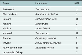
Fish by the number of identified specimens (NISP)

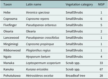
Charcoal results from Layer 3

Shell species weight (g), number of individual specimens (NISP), and minimum number of individuals (MNI) in layer 3

Geomorphological approach
A historical coastal change analysis was performed using the methodology outlined in Jones et al. (Reference Jones, Collings, Dickson, Ford, Hikuroa, Bickler and Ryan2024) to quantify historical erosion and accretion trends. From 1942 to 2023, 17 coastline positions were captured using aerial photography and satellite imagery (Dickson et al., Reference Dickson, Ryan and Ford2022). Vectorised lines in the aerial and satellite imagery represented the coastlines. The edge of vegetation (EOV) was used to define the dune toe, as an indicator for the coastline (Jones et al., Reference Jones, Collings, Dickson, Ford, Hikuroa, Bickler and Ryan2024). The Digital Shoreline Analysis System (United States Geological Survey) was used to assess coastal changes (Himmelstoss et al., Reference Himmelstoss, Henderson, Kratzmann and Farris2021). Weighted linear regression (WLR) and net shoreline movement (NSM) were calculated using the EOV. The WLR was utilised to determine the annual average rate of coastal change. WLR modifies traditional linear regression by assigning weights to coastline data points based on their reliability or significance. The NSM was used to quantify the overall coastline position change over time, reflecting erosion or accretion patterns along the coast. We utilised the centroid of the midden as a reference point to analyse the recovery and erosion of the beach over time.
To acquire topographic elevation data for the dune system, the Northland Regional Council and Land Information New Zealand supplied an LiDAR point cloud. The ground points were classified into a digital elevation model (DEM) using empirical Bayesian kriging with a horizontal resolution of 1 m. Elevation profiles were obtained from the DEM to further examine the prograded-barrier coastal ridge system.
High-resolution three-dimensional models of the foredune and archaeological sites were captured before (3 October 2022) and after (23 February 2023) an ex-tropical cyclone (Gabrielle) that occurred on the 13 and 14 February 2023. The models were captured using an Apple iPad Pro 11″ LiDAR sensor (Polycam app). The scans of the site before erosion served as a baseline for the site’s initial condition, whereas the scans after the cyclone illustrated the extent of the damage caused by the storm.
Mātauranga approach
The conceptual framework Awa Whiria (MacFarlane et al., Reference Macfarlane, Macfarlane, Gillon, Macfarlane, Macfarlane and Webber2015; Wilkinson et al., Reference Wilkinson, Hikuroa, Macfarlane and Hughes2020, Wilkinson Reference Wilkinson2021) was employed to establish the relationships between the different datasets. According to Wilkinson et al. (Reference Wilkinson, Hikuroa, Macfarlane and Hughes2020), this framework posits that discrete strands of knowledge may be interwoven, similar to the intricate pattern of a braided river. These strands may diverge, converge and meander along their paths, but ultimately flow in the same direction, working towards a common goal. Knowledge holders or experts are responsible for safeguarding the knowledge stream and adjusting its path, suggesting appropriate or inappropriate connections. The metaphorical reference to “knowledge kete” or baskets, derived from the Māori whakataukī “nā tō rourou, nā taku rourou, ka ora ai te iwi” (“with your food basket and my food basket, the people will thrive”), symbolises the braiding of Western science and Indigenous knowledge through a Māori worldview, emphasising respect for the integrity and sovereignty of each stream, and the value to be gained by drawing from them both (Wilkinson et al., Reference Wilkinson, Hikuroa, Macfarlane and Hughes2020). Furthermore, this relates to another reference whereby Tāne (deity of forests) brings “ngā kete e toru o te mātauranga” (three baskets of knowledge) the origin of knowledge, from the realms of the deities for humans to use.
It is important to note the selection of the site and the fact that a midden was exposed due to coastal erosion, was ascertained from local knowledge, and is a form of mātauranga. Patuharakeke actively monitor coastal areas in their rohe (territory) as part of their role as kaitiaki (guardians) and actively manaaki (assist) with archaeologists. Working together, archaeologists and kaitiaki attempt to retrieve and care for the information in coastal archaeological sites before they are taken by Tangaroa atua (ocean deity). In practical terms and in the context of Te Akau Beach, key sections of written and oral information from cultural assessments were identified and noted when they pertained to coastal information (following the method outlined in Macfarlane et al., Reference Macfarlane, Macfarlane, Gillon, Macfarlane, Macfarlane and Webber2015). These cultural assessments were provided by Patuharakeke, a tribal nation who are ahi kā (trace their ancestry back to primary ancestors who lived on the land and have continuously occupied these lands) for the area, and hence mana whenua (hold jurisdiction over the area), and contained mātauranga relevant to the research. As the research focused on the coastal evolution of a barrier system, relevant mātauranga was identified in oral and written information. For example, observations related to the coastal barrier system, specifically vegetation cover, how people interact with that system, any natural events observed and potential anthropogenic pressures. The connections between these elements were then discussed among the authors, including how they interconnect with archaeology and geomorphology. To ensure transparent dissemination of information, recorded notes were stored in a cloud drive accessible only to the authors. The selected text was then presented to members of the Patuharakeke Te Iwi Pou Taiao unit to ensure that the text was correctly understood and utilised. This meeting followed a hui (meeting) and wananga (discussion forum), which took place on 12 December 2023 at the Patuharakeke Te Iwi Pou Taiao unit office. Through this process, it was determined how and where certain strands connected and which did not, ultimately contributing to a deeper understanding of the coastal environment in the past. This information is displayed in Table 4, showing how the verified data from the wananga (discussion forum) relate to the archaeological and geomorphological datasets to enhance the interpretive power of the analysis to better elucidate coastal changes in the coastal barrier system.
The table presents the mātauranga of Patuharakeke and the aspect of the research question they relate to. Referenced from Chetham et al., Reference Chetham, Shirkey and Maki-Midwood2020

Results
Archaeological findings
The foredune in which the midden lies reaches ~7.5 m above mean sea level (amsl) (Figure 2, see Table 5 for layer descriptions). The midden (Layer 3) is composed of a single layer ~50 cm thick and occurs near the top of the dune section at ~7 m (amsl) (Figure 3). At the juncture of Layers 3 and 2, there is a fire scoop. Layer 3 is capped by dune sand A (Layer 2) ~0.5 m thick, and below dune sand B (Layer 4) ~1.7 m thick. Below this is a palaeosol (Layer 5) ~0.3 m thick, and below this is dune sand C (Layer 6), which is >5.3 m thick (measured to excavation extent).
Stratigraphy of the foredune

The midden was primarily composed of hūai (cockle, Austrovenus stutchburyi), pipi (Paphies australis) and tio (oysters, Ostrea spp.) (Tables 1 and 3). Of the 76 fish bones identified, 59 were vertebrae and 17 were cranial. There are similar numbers of vertebrae and cranial bones in fish; therefore, the high number of vertebrae relative to the cranial indicates that fish were being processed at the site. Although only 76 bones were identified, the fauna was quite diverse, with 10 species of fish identified. Given the low total number of identified specimens (NISP) score (76), no statistical analysis was performed. Three bird bones were found, one a small fragment, while the other two were from birds of the size of a gull or tūī but could not be identified. Some bone fragments of marine mammals, mostly unfused vertebral plates, were found. These are large (~15 cm long) and most likely originate from juvenile whales.
Charcoal identification in the midden (Layer 3) deposit was a mosaic of kanuka (44%), manuka (22%) and pohutukawa (18%) (Table 2). Charcoal analysis suggests the utilisation of vegetation to produce fire, which may have been employed for cooking or smoking fish and shellfish (Wallace and Holdaway, Reference Wallace and Holdaway2017). The use of fire by individuals is inferred from the presence of charcoal (and fire-cracked rock) among the shells and faunal material in the midden. Below this layer, a dune sand layer (4) lies atop a palaeosol layer (5) that contains bracken, suggesting the presence of herbaceous and small scrub species in the area. However, further analyses to identify specific species would require larger sample sizes. The discovery of predominantly herbaceous material rich in charcoal along the entire length of the foredune, beyond the extent of the midden (3), indicates that a significant quantity of fire accumulated in a continuous layer of charcoal within the foredune.
The radiocarbon ages obtained from Layers 3 and 5 imply a depositional history related to human activity for approximately 580 years (Figure 3). The middle layer (3) is nearly 300 years old with a date range of 220–270 B.P. (95% probability) and the lowermost palaeosol layer (5) was deposited 505–540 B.P. (95% probability). The palaeosol layer is laterally extensive in the subsurface architecture of the dune structure, extending well beyond the midden layer, and is visible in sections along the length of the foredune at Te Akau.
Geomorphological findings
The Te Akau coastal barrier exhibits a distinct arrangement of ridges and swales, as evidenced by the topographic cross section moving inland from the sea (Figure 3). The dune crest is ~7.5 m above the dune toe, with a steep face of ~33°, close to the angle of repose of the dune sand (Shand et al., Reference Shand, Reinen-Hamill, Kench, Ivamy, Knook and Howse2015). The cross-sectional view of the foredune (Figure 3) reveals a notable scarp after cyclone Gabrielle, around 1.5 m high, suggesting that the storm had cut back into the foredune. Landward of the foredune, a series of dune ridges, reaching approximately 13 m in height (asml) extends 200–300 m inland. Based on topographic data, these dunes are typically 12 m wide and characterised as narrow dune ridges. Low (~5 m amsl) and wide (~100 m) beach ridges are present further inland, forming an undulating terrain shaped by the falling sea levels in the late Holocene (Dougherty, Reference Dougherty2011; Dougherty and Dickson, Reference Dougherty and Dickson2012). The approximately 6.5-m difference in elevation between the higher dune ridges near the foredune and lower beach ridges further inland may indicate a change in coastal evolution at some point in time.
A radiocarbon date of 5,750 B.P. obtained on the outer barrier by Osborne (Reference Osborne1983) (Figure 2) indicates that beach ridge formation was active during the mid-Holocene period. Osborne conducted a bulk C14 date on eight shell valves from the beach sand and yielded an age of 5,750 + 140 years B.P. (NZ-6376A). The locations of this date (5,750 B.P.) and the midden date (224–270 B.P. (95% probability) presented herein are separated by approximately 900 m, implying a minimum barrier progradation rate of ~0.16 m per year during the mid- to late Holocene. The scarcity of detailed chronological information means that little can be said about the history of barrier development, including the relative importance of drivers, such as sea level change and sediment supply (Nichol et al, Reference Nichol, Lian and Carter2002). However, it is notable that an abrupt change in barrier morphological development has occurred at some point between beach ridge formation in the mid-Holocene (indicated by the radiocarbon date of 5,750 B.P.) and the development of high foredune in more recent centuries (indicated by the midden and palaeosol radiocarbon dates of 224–270 B.P. and 506–538 B.P. [95% probability], respectively). The midden and palaeosol dates suggest that vertical accretion was occurring in the high seaward foredune between at least 506–538 and 224–270 B.P. Nearly 0.74 m of dune sand separates the midden and palaeosol, indicating a vertical accretion rate of 0.0027 m/year. Above the midden lies 1.5 m of dune sand, indicating a vertical accretion rate of 0.0006 m/year. It is unlikely that vertical accretion is continuous, but rather the result of multiple cycles representative of the change envelope of Te Akau.
Historical coastal change analysis has revealed the erosion and accretion patterns along the Te Akau coastline. In the central and northern regions of Te Akau, particularly near Whangārei Harbour, the coastline is accreting (prograding seaward), with rates ranging from 0.46 to 3.46 m/year (Figure 4). However, there is also erosion, particularly in the sections where the midden has been exposed. The rate of erosion in these areas reaches −0.45 m/year, leading to slumping of the foredune face that contains the midden layer. The presence of the 200-year-old midden shows that coastal erosion has not advanced landward beyond this position in the past 200 years, as the midden remained intact (pre-Cyclone Gabrielle) dating back to 224–270 B.P. Historical coastline positions reveal that the coast has retreated approximately 20 m between 1942 and 2023, with ~10 m of this erosion occurring during Cyclone Gabrielle in February 2023 (Figure 6). The midden (Layer 3) sampled before the storm was severely impacted, where most of the shell material was removed, leaving only a remnant thin black layer of where the midden was (Figure 7).
Results of Digital Shoreline Analysis System over the time period 1942 to 2023 showing A) the weighted linear regression values (m/yr) and B) Net shoreline movement (m). Midden analysed in this paper in red.

Mātauranga Māori
In total, 10 quotes from the mātauranga oral and written history were selected for inclusion in this article (Table 4). Selected quotes are provided in the text of this section alongside relevant information from archaeological and geomorphological datasets. The following passage presents mātauranga that delves into the coastal environment of Te Akau:
Patuharakeke have many wahi tapu [sacred sites] including ancient urupa [burial grounds] that still contain the remains of important and illustrious forebears. Patuharekeke are kaitiaki [guardians] of these urupā [burial grounds]. These are mainly on the coastal fringes, and some have been either eroded away or subsumed already by encroaching mangrove mudflats and in some cases dense overgrowth. (Chetham et al., Reference Chetham, Shirkey and Maki-Midwood2020:45)
The text emphasises two key factors: the location of historical burial grounds along coastal margins, and the threats to significant cultural heritage sites posed by coastal erosion and mangrove growth, as recounted in oral traditions. Moreover, this passage highlights a broader geomorphological context, indicating the destruction of burial sites resulting from coastal erosion in these areas. The next passage highlights the range of past human activities at Te Akau.
Poupouwhenua Block is depicted in Figure 5. This location was an extremely particularly important tauranga waka Footnote 4 and was utilised often by various war parties stopping there to prepare for battles further south. Preparations included training and discussions of tactical warfare. The number of war parties varied between small groups of 20–50 to some numbering in the thousands (Clarke, Reference Clarke2001:2). Up until industrial development in the 1960s, it was utilised by Patuharakeke and whanaunga [relations] tribes as a seasonal nohoanga [occupation site] where a rich harvest of kaimoana [seafood] could be gathered and processed. In earlier times would have likely to have involved entire tribes particularly in times of peace. (Chetham et al., Reference Chetham, Shirkey and Maki-Midwood2020: 14)
A) The historical edge of vegetation (EOV) shorelinecoastline positions of the dune toe (EOV) in blue, while the baseline and cross-shore transects are portrayed in black. B) The boxplots, arranged in chronological order, illustrate the EOV distance from the midden (and baseline in red) for each transect, thereby demonstrating the variability along the shore of the distance of the EOV from the midden. The gray dashed line signifies the location of the midden relative to the baseline.

3-D scan before and after Cyclone Gabrielle. The slumps become overburdened as the dune adjusts, thereby affecting the upper dune vegetation. The redeposited medium material is similar; however, it is a material that has slumped out of the middle layer.

Conceptual model of possible dunefield/barrier evolution at Te Akau, adapted from Enright and Anderson (Reference Enright and Anderson1988).

Families would live mainly on the coast for a rich harvest of kaimoana. Food gathering would involve entire tribes at times and operations such as netting or fishing both inland and out to sea. (Chetham et al., Reference Chetham, Shirkey and Maki-Midwood2020: 48)
The details in these histories align with the archaeological evidence uncovered in this study, offering insights into the daily lives of past individuals within the coastal environment.
a rich tapestry of signifiers of traditional relationships with the Northport area. This includes the relationship of Whangarei Terenga Paraoa [the gathering place of whales] as a bountiful and rich food basket or ‘pataka’ that hosted seasonal migrations of descendants from in and around the [kinship] related inland hapu [grouping of families] to harvest kaimoana. According to Patuharakeke elders, prior to the construction of the refinery, a substantial mussel bed covered the takutai [seafloor] adjacent to the site, ranging from the edge of the channel into shallow water and running from Mair Bank along to the Port Jetty. “When an easterly gale blew you could just roll carpets of mussels into your sack.” (Living Memories Hui, Rangiora, Takahiwai 1998) (Chetham et al., Reference Chetham, Shirkey and Maki-Midwood2020: 45)
This evidence details the significant abundance of kaimoana, which is supported by archaeological findings.
Pīngao (sand sedge, Descmoschoenus spiralis) used specifically to make piper nets was gathered in Te Akau and Rauiri areas. (Chetham et al., Reference Chetham, Shirkey and Maki-Midwood2020: 45).
This knowledge of coastal vegetation present in the past pertains to the geomorphological strand, as pīngao only grows in coastal dune areas, predominantly the foredune (Bergin and Herbert, Reference Bergin and Herbert1997).
Discussion
This study presents an analysis of a prograded coastal barrier system in Aotearoa/New Zealand as an example of how braiding the methods of archaeology, geomorphology and Indigenous knowledge can provide more detailed information about historical coastal change compared to using just one method alone.
Archaeological and mātauranga braid
Coastal barriers in Aotearoa have been frequented by Māori for hundreds of years, as they are ideal locations for fishing and shellfish gathering (Campbell et al., Reference Campbell, Bickler and Clough2004). An archaeological investigation of the Omaha Sandspit (Figure 1) identified 249 middens along the length of the barrier, dating between approximately 550 and 250 B.P., indicating a long period of occupation and utilisation of the area (Campbell et al., Reference Campbell, Bickler and Clough2004). Based on the known archaeological evidence and similarities in barrier geomorphology, is likely that Te Akau/Bream Bay barrier has a comparable settlement history to Omaha Sandspit. Archaeological evidence from Te Akau shows that seasonal temporary encampments, where widespread shellfish processing activities occurred, were common from approximately 450 B.P. onwards (Bickler et al., Reference Bickler, Farley, Plowman and Clough2007; Campbell, Reference Campbell2005; Reference Campbell2006; Phillips and Harlow, Reference Phillips and Harlow2001; Prince, Reference Prince2003). Archaeological sites in Te Akau contain an abundance of hūai (Austrovenus stutchburyi, cockle). The sandy spit at Patangarahi/Snake Bank, located 1.5 km inside Whangarei Harbour, is a rich source of accessible hūai. Similarly, the coastline at Te Akau also contains significant quantities of pipi (Paphies australis) and tuatua (Paphies subtriangulata), which can still be found in the intertidal and subtidal zones along the beach (Williams et al., Reference Williams2009). Results from this research, reported through Patuharakeke mātauranga, confirm that the area served as a dwelling place where people camped, gathered and caught kaimoana. Further, it is reported that at Te Akau the deceased were interred, and spaces were dedicated for canoe landing. The mātauranga suggests continuous use of the area, which is likely to have impacted the archaeological record and geomorphological systems, which is discussed further below.
Archaeological findings from this research indicate continuous human utilisation of the Te Akau coastal area between 550 and 150 B.P., consistent with the Patuharakeke mātauranga (Table 6). The midden studied in this article is one of several known middens situated on the southern bank of the Whangārei Harbour. Archaeological evidence and mātauranga suggest that marine resources are exploited seasonally for food procurement, storage and trading. Other archaeological findings in the area have revealed middens within the immediate vicinity of Te Akau, ranging from 450 to 150 B.P. (Jones et al., Reference Jones, Larsen, Clough-Macready, Bickler, Clough and Phear2019). These middens provide evidence of shellfish harvesting across the strand plain, where dune ridges provide locations for preparing, processing, cooking and drying marine resources.
Species selected for C14 dating

The primary components of the midden are hūai, pipi and tio (oysters). Notably, mussel shells (mentioned in the mātauranga) were absent in the middens investigated in this study, whereas oysters, which require a hard substrate to attach to and hence must have been brought to the site from elsewhere, were present. The small fish assemblage was dominated by aua (yellow-eyed mullet, Aldrichetta forsteri) and hature (mackerel, Trachurus spp.), which was most likely harvested using nets (Campbell et al., Reference Campbell, Shepherd, Kellett and Brassey2022). Tamure (snapper, Chrysophrys auratus) is typically abundant in upper North Island middens, but is uncommon in this assemblage, along with other larger species that are often caught on baited hooks (Campbell et al., Reference Campbell, Shepherd, Kellett and Brassey2022). Despite the small size of the assemblage (76 identified specimens, the NISP), it seems to represent a specialised fishery.
Mātauranga suggests that the faunal and charcoal remains in the midden could be related to the cooking and drying of fish and shellfish, or to swidden horticulture, where patches of coastal vegetation were cleared for this purpose. This activity may have led to the formation of a continuous palaeosol with an abundance of charcoal within the matrix. The palaeosol charcoal preserved within the eroded foredune at Te Akau is found throughout the length of the foredune (extending laterally in the exposed foredune beyond the midden area). It is dated at 506–538 B.P. and includes herbaceous charred remains that suggest a fire that was likely fuelled by vegetation and ignited either by natural or human activity.
The archaeological findings of the paper are linked to the mātauranga, which suggests that families spent significant time on the coast catching a rich harvest of kaimoana. Food gatherings involved numerous tribes at times, and operations such as netting or fishing were conducted both inland and on the coast. The faunal material in the archaeological deposits aligns with mātauranga, providing a broader understanding of how and where people interacted in the coastal zone and greater confidence in our findings. The middens at Te Akau are situated within a larger cultural landscape, and archaeological evidence suggests that humans used the area seasonally. This aligns with Patuharakeke mātauranga, the reliable empirical knowledge gathered and tested through generations, and their associated expertise, as confirmed in Table 6. The potential loss of pre-human coastal vegetation may have led to a dynamic dune system, as seen at Mangawhai, south of Te Akau (Enright and Anderson, Reference Enright and Anderson1988). We consider this in more detail below.
Archaeological and geomorphological braid
Late Holocene sea level in Aotearoa was once thought to be relatively stable (Gibb, Reference Gibb1986), but in northern New Zealand, it is now considered that a sea level highstand probably reached a maximum of 1–2 m amsl around 4k B.P. before gradually declining towards the present level (Clement, Reference Clement2011; Clement et al., Reference Clement, Whitehouse and Sloss2016; Dougherty and Dickson, Reference Dougherty and Dickson2012; Hayward et al., Reference Hayward, Grenfell, Sabaa, Kay, Daymond-King and Cochran2010a, Reference Hayward, Wilson, Morley, Cochran, Grenfell, Sabaa and Daymond-King2010b, Reference Hayward, Grenfell, Sabaa and Kay2010c). The scarcity of detailed chronological information for beach and dune ridges at Te Akau prevents a detailed assessment of the likely link between Holocene sea-level change and barrier development (Nichol, Reference Nichol2001), but a radiocarbon age from Osborne (Reference Osborne1983) and the midden chronology obtained in this study provide some rough constraints that we present in Figure 2. Beach ridge progradation was active in the mid-Holocene (radiocarbon age of 5,750 B.P.; Osborne Reference Osborne1983), which is somewhat earlier than the initiation of chenier barrier progradation inferred from the Firth of Thames (Figure 1) around 4k B.P. (Dougherty and Dickson, Reference Dougherty and Dickson2012; Woodroffe et al., Reference Woodroffe, Curtis and McLean1983). It is possible that a high rate of sediment supply at Te Akau promoted earlier barrier progradation, but further dating of the beach ridges would be required to assess that prospect. Regardless, it is apparent that barrier progradation continued between the mid-Holocene until sometime before 224–270 B.P., at a rate of at least 0.16 m/year. This progradation was supported by a falling sea level in the mid-late Holocene, and it seems likely that progradation slowed as the sea level approached the current level and stabilised.
The large foredune ridge is a conspicuous feature of the Te Akau dune system. Anthropogenic impacts are likely an important component of the development of this ridge. The presence of midden and palaeosol deposits capped by dune sand deposits suggests that vertical accretion of the foredune has continued over the last 200 years, despite the barrier now being in a laterally eroding state. Fires might have removed coastal vegetation, remobilising sand that was formerly trapped in vegetated beach and dune ridges. The primary components of charcoal found in the midden are small scrub species, while palaeosol layer 5 is virtually entirely bracken. The accumulation of charcoal deposits across Aotearoa during the pre-contact Māori settlement period coincided with evidence of soil instability or forest replacement by herbaceous communities (McGlone, Reference McGlone1983). Humans in the past have used fire for various purposes, including land clearing for access, hunting, horticulture and slash-and-burn agriculture (McGlone, Reference McGlone1983). Repeated burning is necessary to accomplish these objectives, as it prevents forest succession and results in permanent vegetation changes (Enright and Anderson, Reference Enright and Anderson1988).
Enright and Anderson’s Reference Enright and Anderson1988 barrier evolution model from Mangawhai, located ~30 km south of Te Akau, is useful in understanding dune development at Te Akau (Figure 7). According to their model, a large fire occurred around 800 years ago, clearing a mixed forest that included totara, kanuka, titoki, lacebark and maire. This forest grew on sandy soils, on a coastal hill about 20 m high and 300 m from the sea. The fire’s destruction of coastal vegetation initiated a period of instability. Enright and Anderson (Reference Enright and Anderson1988) noted that after the fire, there was a volcanic ashfall, known as Kaharoa, dated to between 650 and 670 years B.P. The Kaharoa ash was found in remnant swales at Mangawhai, suggesting that the coastal area underwent significant deflation and erosion following the fire, where palaeosols formed on top of the ashfall deposits. Between the Kaharoa ashfall and the emergence of middens (around 650–400 years B.P.), the topography changed considerably. A deflation surface developed between the retreating foredune and the coastal hill, causing high dunes to form as sand accumulated from the deflating surface. From 400 years B.P. to the present, almost the entire foredune system has disappeared, with high dunes and scarp formation replacing it.
Applying this model to Te Akau (Figure 7), we see a similar pattern. An extensive fire (the date possibly 800 B.P. if we follow the Enright and Anderson’s (Reference Enright and Anderson1988) model) cleared a pre-contact mixed forest containing species like totara, kanuka, titoki, lacebark and maire. Unlike Mangawhai, Te Akau shows no evidence of the Kaharoa ashfall. Instead, signs of the fire were quickly re-deposited into depressions like dune swales, forming palaeosols. A palaeosol in this study was dated to about 506–538 B.P., and middens at Te Akau were dated to around 224–279 B.P. Between the formation of the palaeosol and the midden deposition, Te Akau experienced significant topographical changes, similar to Mangawhai. The retreating foredune caused high dunes to form as sand accumulated from the deflation surface. The coastal erosion that has occurred over the past 80 years (as evidenced by the coastline change analysis) and associated foredune instability might have erased parts of the earlier landscape, removing any evidence of palaeosols that were deposited further seaward of the midden analysed.
Mātauranga and geomorphology braid
Patuharakeke mātauranga record that pīngao was present in the coastal vegetation at Te Akau. Pīngao is an endemic sand-binding plant that is widespread on foredune in both the North and South Islands of Aotearoa before European contact (Bergin and Herbert, Reference Bergin and Herbert1997). Pīngao is said to be Ngā Tukemata o Tāne (the eyebrows of Tāne), given as a peace offering to Tangaroa atua, however, “Tangaroa rejected this gift and threw them to the shore. There they sprouted and grow today as pīngao, symbolising the boundary between the realms of Tāne and Tangaroa” (Wassilieff Reference Wassilieffn.d., p. 1). The mātauranga notes pīngao was used for fishnets and is one of the four natural fibres that Māori extensively use for braiding (McKendry, Reference McKendry2020). This is an important observation, as this species has not been detected in the charcoal from the midden deposit (3) and is not typically found in archaeological contexts in Aotearoa, possibly due to preservation issues. Pīngao has a significant role in shaping coastal dune morphology by stabilising sandy areas and creating a continuous, hummocky alongshore landscape (Konlechner et al., Reference Konlechner, Ryu, Hilton and Sherman2015). Currently, pīngao is scarce on the dunes at Te Akau, where restoration of the species is a key aspect of Patuharakeke’s coastal taiao work.
While archaeological records do not identify any pre-contact urupā (burial sites) along the Te Akau coastline, mātauranga indicates that such sites are present, suggesting that they may be at risk from coastal erosion. Patuharakeke mātauranga also records that tohorā (whales) and human remains were historically buried in dunes to allow for natural decay, with the bones later retrieved. Given that the paper shows erosion in the central portions of Te Akau, this knowledge can be used to focus monitoring done by the taiao unit and support efforts to ensure that any exposure of urupā or tohorā remains is promptly addressed. By weaving this mātauranga with coastal change data that show hotspots of local coastal erosion, coastal management can be tailored to protect culturally significant sites at risk from coastal changes.
Loose strands – compatibility and incompatibility of Western and Indigenous knowledge
This study has attempted to braid archaeological, geomorphological and mātauranga Māori methodologies to enhance our comprehension of coastal behaviour during the late Holocene (Figure 8). The core research focus of each knowledge system occasionally diverges. An illustration of this is the mention of taniwha, which, although not directly relevant to the overarching question of accretionary dune development, contributes to a deeper understanding of how people perceived and interacted with aspects of past landscapes, and what was potentially viewed as a hazard (Hikuroa, Reference Hikuroa, Heandtlass, Morgan and Neale2020). The mātauranga of Patuharakeke highlights the presence of two taniwha (powerful creatures), Te Rakepatupaiarehe and Pokapuwaiorehua, near Whangārei Harbour. Stories of taniwha that cause destructive surges that threaten the lives of individuals close to the water are prevalent throughout coastal Aotearoa (e.g., King and Goff, Reference King and Goff2010; King et al., Reference King, Shaw, Meihana and Goff2018; King et al., Reference King, Manawatu and Shaw2020; McFadgen, Reference McFadgen2007). As King and Goff (Reference King and Goff2010) state, taniwha-related mātauranga suggests a long-standing recognition of the potential for treacherous conditions along a region’s coastline. These taniwha mātauranga were developed to explain environmental hazards and have origins in traditional ways of interpreting natural phenomena as signs of something more than mere biophysical processes. Through their codification, they serve as effective disaster risk reduction mechanisms (Hikuroa, Reference Hikuroa, Heandtlass, Morgan and Neale2020). The existence of taniwha raises future research avenues and directly connects how people perceive and interact with past coastal spaces. This is an example of how various techniques are applied to different forms of knowledge braids. This application produces a wide array of information. However, tension arises when trying to incorporate this diverse information into a cohesive conclusion. This tension stems from the challenge of appropriately synthesising the varied data into a unified understanding or result. It is about finding the right balance and making sense of all the different pieces of information gathered from the research. What is important from a research view can also potentially conflict with community aspirations.
Venn diagram illustrating the overlap between coastal geomorphology, mātauranga, and archaeology.

Wilkinson et al. (Reference Wilkinson, Hikuroa, Macfarlane and Hughes2020) highlight that Māori groups have unique values, priorities and interests in research situated in their frame of reference. For example, according to Tau (Reference Tau1999), blending Māori knowledge with references to places, ancestors and key figures as memory cues can help retain crucial information. For Patuharakeke, who are responsible for their mātauranga and the stewardship of their rohe, their aims include preserving ancestral knowledge and practices and restoring cultural landscapes and taonga species. Middens, discussed in this article, reveal past fishing and harvesting practices and types of wood used in coastal areas. Charcoal’s plant composition offers clues for selecting plants to restore cultural landscapes. This proactive approach aligns with Patuharakeke’s goal to preserve and restore vital cultural elements. The primary focus of the research in this article aligned with the aspirations of Patuharakeke.
However, this is not always the case as Western science and Indigenous knowledge have different frames of reference. However, by pursuing a common aspiration that led to weaving these diverse knowledge systems, we argue interpretive power of the past is enhanced. The paper argues that these differences in knowledge production can facilitate co-creation and collaboration, benefiting both scientists and Indigenous communities. It benefits science as without this collaborative approach, research results can end up in the hands of the community, requiring them to interpret the findings without adequate support from the researchers. Open discussions and relationship-building throughout research projects can help address this issue, providing flexibility and enabling new research directions that might not strictly follow the original objectives but can yield valuable insights.
Conclusion
This article braids archaeological and geomorphological evidence with mātauranga Māori to try to improve understanding of coastal change within a sand barrier across decadal to millennial timescales. The main findings of this study are as follows: (1) Te Akau has experienced erosion of the foredune in the last 80 years, as indicated by the coastal change data and the exposed cultural sites; dating of which suggests the coast is presently in the most eroded state in at least the last 200 years; (2) the results of this research support hapū in the revitalisation and preservation of knowledge and goals for the restoration of cultural landscapes and taonga species and (3) this case study of weaving Western and Indigenous knowledge was relatively successful, and we argue that this type of research is crucial for a more detailed understanding of coastal change in local contexts. These findings aid the development of more effective coastal management strategies that can help mitigate the consequences of erosion and other coastal hazards in the context of SLR.
Open peer review
To view the open peer review materials for this article, please visit http://doi.org/10.1017/cft.2024.18.
Supplementary material
The supplementary material for this article can be found at http://doi.org/10.1017/cft.2024.18.
Data availability statement
The mātauranga data, which is integral to our research, is held and facilitated by Patuharakeke (including authors J. Chetham and A. Carrington). This includes the knowledge and insights gained from the coastal taiao (environmental) monitoring unit that discovered the midden. As these data are of cultural significance, they are not publicly available but were used with the permission and guidance of Patuharakeke.
The archaeological data used in our study, including the anthropogenic deposits within the dune stratigraphy and their radiocarbon dating, are also not publicly available due to the sensitive nature and the need to preserve the integrity of the sites.
The geomorphological data, including topographic data, historical aerial photographs and satellite imagery, will be made publicly available. These data are hosted on a GitHub repository (https://github.com/Thepastfromabove/Braiding-Archaeology). Please note that any use of these data should be properly cited and acknowledged.
We believe in open science and are committed to making our research as transparent and accessible as possible while respecting the cultural and archaeological sensitivities involved. We appreciate your understanding and cooperation.
Acknowledgements
Many people and agencies have contributed to this study. The authors thank Land Information New Zealand (Shannon McColley), Northland Regional Council, The Department of Conservation (Carole Tilman), Heritage New Zealand (Vanessa Tanner) and most importantly, Patuharakeke. The authors owe much of the success of this excavation and the resultant findings to the local help they received from the Patuharakeke Taiao unit Kaitiaki and Patuharakeke Te Iwi Trust Board, Xzavier Watson and Bugie Carrington, and volunteers Matthew Barrett, Kirstin Roth, Aaron Aphel and Lovleen Acharya Chowdhury. The authors thank Dr. Matthew Campbell (Faunal identification), Dr. Rod Wallace (Charcoal Identification), Kirstin Roth (Shellfish Identification) and Mere Kepa (Te Parawhau) for their specialist expertise. Archaeological and Bayesian modelling guidance was provided by Dr. Simon Bickler, Mana Laumea and Dr. Fiona Petchey. The authors also wish to acknowledge and thank the University of Auckland Faculty of Science Technical Services team member Thomas Mules for access to the Geo-Computational Laboratory and discussions on data processing, whose invaluable assistance helped make this research possible. Finally, the authors acknowledge the contribution made by the Handling editor Louise Celliers and reviewers of this article, which increased the overall quality and presentation.
Author contribution
The lead author, I (Benjamin D. Jones) conducted the majority of the research, including data collection, analysis and manuscript writing. This work is part of his Ph.D. thesis by publication. The co-authors contributed to the study’s design, provided feedback and approved the final manuscript.
Financial support
This research was financially supported by several sources. The primary funding was provided through a PhD scholarship awarded to Benjamin Jones by the Coastal Program of the Resilience to Nature’s Challenges, Kia Manawaroa – Nga Akina o Te Ao Turoa. Additional financial backing was generously provided by the Skinner Fund of the Royal Society Te Aparangi. This fund has significantly facilitated the research process and contributed to the successful completion of the project. Finally, the New Zealand Coastal Society’s Student Research Scholarships also played a crucial role in supporting the project. These scholarships provided essential financial aid to the student researchers involved, further enabling the successful execution of the research. The authors express their sincere gratitude to all the funding bodies for their generous support. Their contributions have been instrumental in the successful completion of this research.
Competing interest
The authors declare no conflict of interest.
Ethics statement
The nonindigenous authors (Mark Dickson, Emma Ryan and Murray Ford), and especially the first author (Benjamin D Jones) who conducted the fieldwork, analysis and co-lead the hui (meetings), sought the expertise of Indigenous researchers in mātauranga to ground and co-write the research (Associate Professor Daniel Hikuroa, Juliane Chetham and Ari Carrington). This experience has guided the first author, who is a nonindigenous researcher, to actively engage in culturally and socially responsible relationships and participate in student–teacher interchanges as a manuhiri (visitor) researcher. By doing so, all the authors respect the tino rangatiratanga (right of self-determination over mātauranga and cultural heritage) of Tangata whenua (local people), as affirmed by Te Tiriti o Waitangi (The Treaty of Waitangi).
Furthermore, the research design incorporates oral traditions through knowledge exchange in a manner that respects mātauranga. The shared environmental mātauranga came from co-authors Juliane Chetham and Ari Carrington, who are mandated representatives of Patuharakeke, the mana whenua (recognised ancestral Indigenous nation) in the rohe (areas) of Te Akau and Te Poupouwhenua.
The oral traditions are from cultural assessments that were provided by Patuharakeke, a tribal nation who are ahi kā (trace their ancestry back to primary ancestors who lived on the land and have continuously occupied these lands) for the area, and hence mana whenua (jurisdiction over the area) and which contained Mātauranga relevant to the research. To ensure transparent dissemination of information, recorded notes were stored in a cloud drive accessible only to the authors. The selected text was then presented to members of the Patuharakeke Te Iwi Pou Taiao unit to ensure that the text was correctly understood and utilised. This meeting followed a hui (meeting) and wananga (discussion forum), which took place on 12 December 2023, at the Patuharakeke Te Iwi Pou Taiao unit office.


 Open access
Comments
Dear Professor Tom Spencer,
I am writing to submit our manuscript entitled “Braiding archaeology, geomorphology, and indigenous knowledge to improve the understanding of local-scale coastal changes” for consideration for publication in Cambridge Prisms: Coastal Futures.
Our study aligns with the journal’s scope of exploring all aspects of coastal systems, their complexity, and how they change over time. In particular, our work contributes to understanding the dynamics of these interactions and their indications for the future.
In our paper, we present a methodology for weaving indigenous knowledge, specifically mātauranga Māori (Aotearoa New Zealand) and science, specifically geomorphological, and archaeological approaches to gain a deeper understanding of coastal landscape development. We focus on coastal landforms and associated archaeological records that are at risk of erosion from a combination of rising sea levels and increasingly frequent high-intensity storms.
Our study analyses a prograded Holocene foredune barrier in northern Aotearoa New Zealand using archaeological, geomorphological and mātauranga Māori techniques and data. Anthropogenic deposits within dune stratigraphy are radiocarbon-dated and used as chronological markers to constrain geomorphological evolution, alongside geomorphological analyses of topographic data, historical aerial photographs, and satellite imagery. Mātauranga Māori of ecological and fishery practice and traditions also played a vital role in this project. In addition, it was the coastal taiao (environmental) monitoring unit of the local tribe Patuharakeke that discovered the midden. The work of iwi like Patuharakeke demonstrates the active use of mātauranga Māori, woven with western science methods to preserve or capture the knowledge contained within archaeological sites at risk of being lost to coastal erosion.
We believe that our manuscript is a good fit for Cambridge Prisms: Coastal Futures as it provides valuable insights into the dynamics of coastal systems and offers a novel approach to understanding their future development. We appreciate your consideration of our manuscript for publication in your journal.
Kind regards, on behalf of all co-authors,
Benjamin D Jones