


Introduction
Norway was colonized at the transition to the Holocene when most of the Scandinavian peninsula was still covered by an ice cap. The pioneers journeyed into a pristine and unknown landscape quite different from the lowland areas they derived from. The consensus (Manninen et al. Reference Manninen, Damlien and Kleppe2021) is that a pioneer population deriving from the north European plains via the Swedish west coast arrived at the west coast of Norway c. 9300 bce, after which they quickly colonized the entire length of coast. Some pioneers also arrived in the northeast from Russian areas but appear to have made no impact west of the North Cape prior to c. 8200 bce, at which point the eastern groups contributed to significant technological and probably genetic changes along the coast from north to south.
Here we contextualize 11 so–called ground rock-art sites (occasionally referred to as polished) in northern Norway from the early Holocene (c. 9000–7000 bce) as part of a prolonged colonization process, which included wayfinding, exploration of and familiarization with landscapes and environment.
The ground rock art stands out as a distinct group of sites in northern Europe. There are only 11 known sites from a limited geographical region (Fig. 1), and while Fennoscandian rock art sites are numerous from c. 5300 bce onwards, only these 11 sites date to the early Holocene, c. 9000–7000 bce. They are therefore contemporary with the colonization of the Norwegian Atlantic coast and the consolidation of habitation following the immigration.

The perspective pursued here situates the rock art in a wider hunter–fisher–gatherer landscape, incorporating both local topography and wider geography. In particular, it deals with human–landscape relations during a colonization process. It does not, however, engage in the choice of motifs, as a key point here, in contrast to many rock-art studies, is to explore human–landscape relations rather than the selection of species depicted.
We argue that the ground rock-art sites mark natural features or landscapes in several different contexts. Some sites were linked to initial wayfinding, while others were located at particularly animate landscapes.
Foragers in a pioneer landscape: landscape, demography and mobility
The Norwegian coast was colonized by boat, presumably skin boats, as soon as the glaciers in the Oslo fjord area receded, opening for exploration along the ice–free coast (Glørstad Reference Glørstad, Harff, Bailey and Lüth2016). Radiocarbon dates indicate that the first immigrants arrived around 9300 cal. bce. In many areas, and notably in Nordland County, the ice cap and glaciers remained present and visible from the coast (Høgaas et al. Reference Høgaas, Dahl, Smelror, Dahl, Halvorsen, Smelror and Torstensen2022, 98; Hughes et al. Reference Hughes, Gyllencreutz, Lohne, Mangerud and Svendsen2016). Even today some glaciers are visible from the sea, and a few glacier tongues almost reach a fjord.
At the transition to the Holocene the de-glaciated islands and coastal areas in the northernmost parts of the Scandinavian peninsula were barren with limited and low vegetation, a shrub–tundra landscape with willow and birch dwarf shrubs and a few birch trees in sheltered places (Sjögren & Damm Reference Sjögren and Damm2019, 25). This held a limited diversity of Arctic land species such as reindeer, but marine fauna and sea birds were present in large numbers (Breivik Reference Breivik2014). As the climate warmed the interior ice cap diminished, being reduced to isolated glaciers c. 7000 bce (Hughes et al. Reference Hughes, Gyllencreutz, Lohne, Mangerud and Svendsen2016), and the tundra gradually gave way to open birch woodland, documented prior to 8000 cal. bce (Sjögren & Damm Reference Sjögren and Damm2019, 28).
The archaeological data indicate that the early Holocene population density was low, consisting of small and highly mobile residential groups with a strong preference for the outer coast. As the climate warmed and stabilized, so did fauna and flora, and there are indications of a significant population increase in the mid Holocene during the fifth millennium bce (Jørgensen Reference Jørgensen2020) and semi–sedentary settlement patterns from then onwards.
Studies of lithic technology suggest that the main early immigration route led from southern Scandinavia along the Norwegian coast. The lithic industry was remarkably uniform along the Norwegian coast, with only a few sites in the far northeast indicating immigration from the east. A new technological wave from the east, potentially associated also with new immigration, can be dated to c. 8200 bce (Manninen et al. Reference Manninen, Damlien and Kleppe2021). This second wave led to a distinct shift in blade technology from the north all along the Norwegian coast and marked the transition to the Middle Mesolithic (Table 1). There were, however, no marked changes in settlement patterns and many locations were inhabited repeatedly through both Early and Middle Mesolithic.
Overview of phases and chronology in northern Norway.

Of 778 known Early Mesolithic (9500–8000 bce) sites, 96 per cent were located on the coast (Breivik Reference Breivik2014, 1481). A more detailed survey from central Norway revealed a preference for the outer archipelago (87 per cent), with 8 per cent at fjord mouths and sounds and only 5 per cent either in inner fjords or inland/highland (Breivik & Bjerck Reference Breivik, Bjerck and Blankholm2018). A similar distribution is found in western and northern Norway (Bang-Andersen Reference Bang-Andersen and Blankholm2018; Blankholm Reference Blankholm and Blankholm2018a,b; Svensen Reference Svensen, Persson, Riede, Skar, Breivik and Jonsson.2018). The location of sites primarily to the outer coast demonstrates that boats were the main form of transportation and relocation (Bjerck Reference Bjerck2017). Apart from island–based sites and the necessity to cross fjords and sounds, boats were often required even between settlements along stretches of the mainland, as the topography still lacked low, flat foreland, and steep cliffs and ravines prevented journeying on land. This made these landscapes more maritime than they appear at first glance.
Many sites consist only of small lithic scatters, sometimes with a fireplace, but c. 30 dwellings are securely dated to the Early Mesolithic (Fretheim Reference Fretheim2024). These are all small (most less than 10 sq. m) and interpreted as tent rings.
The combination of a uniform technology (indicating extensive networks across long distances), insubstantial dwellings (small, short-term and movable) and the preference for the outer archipelago, suggests a small, highly mobile population living and moving mainly in small groups (a few residential units), keeping predominantly to the outer coast. The preference for outer coastal, often exposed locations, also indicates that marine resources (sea mammals, birds and perhaps fish) must have dominated the livelihood, although some inland/highland hunting also took place (Bang-Andersen Reference Bang-Andersen and Blankholm2018; Breivik & Callanan Reference Breivik and Callanan2016).
This settlement pattern continues into the Middle Mesolithic (c. 8200/8000–6500 bce), but after 7500 bce the dwelling remains increase in numbers, diversify in size, and many appear more substantial with shallow sunken floors (Fretheim Reference Fretheim2024; Gjerde & Skandfer Reference Gjerde, Skandfer and Blankholm2018). The very rapid spread of the new pressure blade technology at c. 8200 bce supports continued existence of extensive networks, presumably associated with long-distance travel. Several studies suggest that in the Middle Mesolithic this is combined with local logistical settlement patterns, with a few substantial base camps (with dwelling remains and large quantities of lithic debris) and numerous small hunting/fishing camps (Bjerck Reference Bjerck1990; Grydeland Reference Grydeland2000). A recent study from southeastern Norway reveals continuity in settlement location in the outer archipelago in the early Middle Mesolithic, but with increasing use of inner sounds and fjords after 7500 bce (Berg-Hansen et al. Reference Berg-Hansen, Hårstad and Granados2022), and this pattern likely also fits other parts of the coast.
Ground rock art: motifs, panels and dates
Ground rock art has only been found at 11 locations, all in Nordland County in Norway. There is a cluster of eight sites in the Ofoten region in the north, and three sites 120–200 km further south. There are no other early Holocene rock-art sites in northernmost Europe. However, as has been noted from the initial recognition of the ground style (Gjessing Reference Gjessing1932; Hällström Reference Hallström1909; Reference Hallström1938) there is an additional number of slightly later sites (dated to c. 7000–4000 bce: Gjerde Reference Gjerde2010, 195–7) with similar single line outlines of large zoomorphs made by pecking rather than grinding. These have a wider distribution, and while found at several sites in Ofoten they also occur further north and south along the coast as well as in the adjacent interior of northern Sweden (Forsberg Reference Forsberg, Barndon, Innselset, Kristoffersen and Lødøen2006; Gjerde Reference Gjerde2010; Hallström Reference Hallström1960; Sognnes Reference Sognnes2012). For the current study only the early ground sites in Nordland are considered.
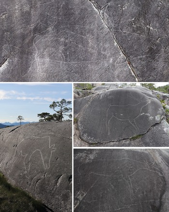
The ground rock art is characterized by large, often near life–sized zoomorphic motifs (Fig. 2). The most common motifs are elk, reindeer and bear, and sea mammals such as seal, porpoise and orca (killer whale) (Table 2). A few birds (swans) and a hare are also known. While the ground rock art was long assumed to include only zoomorphs, outlines of two boats were recently identified (Gjerde Reference Gjerde2021). The largest orca is 7.62 m long, many elk and reindeer are 2–3 m long, and the best-preserved boat more than 4 m. However, some motifs are smaller than life-sized, for example, a bear of 1.3 m (Hallström Reference Hallström1938, 103). The motifs are often described as naturalistic, and many are highly realistic in their representation of the animals. However, as the size varies, so does the stylistic execution, and several are today hard to identify to species level, due either to preservation issues or to lack of detail and finesse.
Examples of motifs. (Top) Orca at Leiknes (7.62 m) overlapping with an elk and a reindeer; (left) bear at Valle (2.26 m); (right, top) reindeer at Jo Sarsaklubben (1.60 m); (right, bottom) elk at Vågan (3.15 m). (Photographs: J.M. Gjerde.)

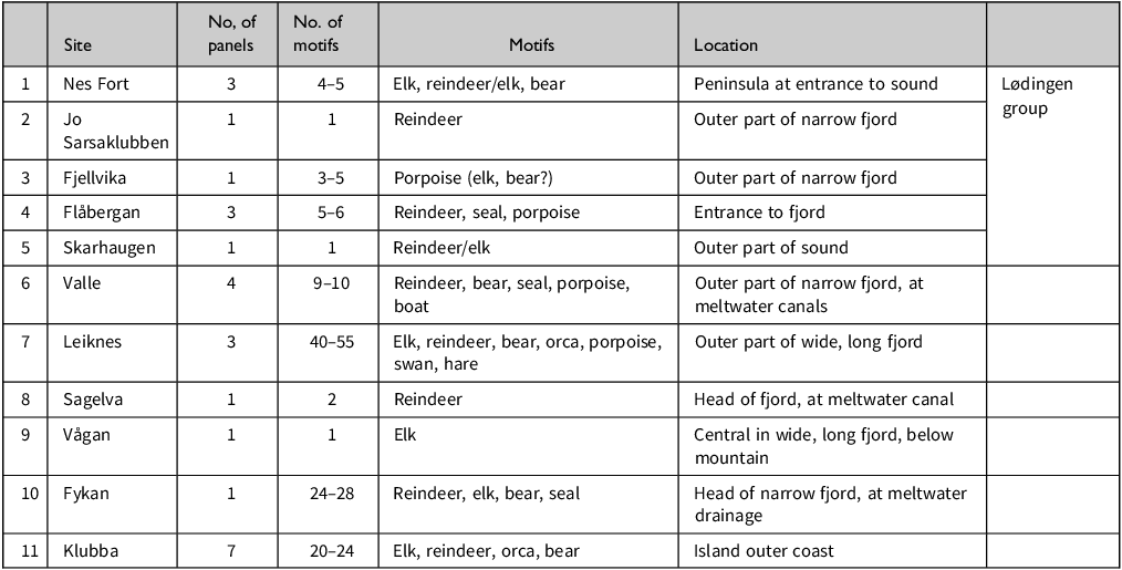
The 11 sites with details of number of panels, motifs, diversity in motifs depicted as well as brief description of geographical location.

The motifs were made through single line outlines, although antlers, ears, eyes, or a line marking the mouth may be added. A few motifs have a so-called life-line running from the mouth to an oblong feature in the chest. The lines are typically 2–4 cm wide and most likely made by grinding a stone on the surface of the granite bedrock (Hallström Reference Hallström1909). In a few cases natural features on the rock surface (cracks, colour variations, etc.) were incorporated in the image (to represent a mouth or the waterline, for example) (Gjerde Reference Gjerde2010, 232–5).
Most panels have one to four motifs, although one has more than 40 (Leiknes I). However, some sites have several panels with one or a few motifs each in the vicinity of each other, increasing the total number of motifs at sites (e.g. Klubba, Fykan and Valle). Many reports contain observations of additional lines or parts of animals. It is nearly impossible to conclude whether these are parts of incomplete or vanishing motifs or if the registrants’ efforts to discern motifs led to misinterpretation of natural anomalies on the rock surface. This has led to inconsistencies in previous records, for example at Leiknes, where the documentation by Gjessing (Reference Gjessing1932) and Hallström (Reference Hallström1938) differs markedly.
The motifs are located on bare granite surfaces, typically with a relatively steep angle. Some sites have near-vertical panels (Valle, Jo Sarsaklubben, Flåbergan, Sagelv, Skarhaugen) while others have an inclination lower than 45 degrees (Vågan, Klubba, Fykan, Leiknes, Nes, Fjellvika).
From the initial discovery of the ground rock art at the very end of the nineteenth century (Helland Reference Helland1900), the sites have been dated through shoreline displacement (Rekstad Reference Rekstad1916). Shoreline dating is widely employed in Norway due to the significant isostatic uplift during the Holocene and because an overwhelming majority of the forager sites are located by the sea. The method is still used extensively to date rock art in Norway, as few other dating methods are available. Of course, dating through shoreline displacement will only provide a maximum date for the site—an indication of when isostatic uplift raised the bedrock on which the panels were later located to dry land.
Systematic studies employing geological modelling for shoreline displacement in northern Norway (Møller Reference Møller1989; Møller & Holmeslet Reference Møller and Holmeslet2002/2012) revealed surprisingly similar and early dates for the ground rock-art sites, placing them all before 8000 uncal. bp, and many before 9000 bp, suggesting calibrated maximum dates between 9300 and 7100 bce (Gjerde Reference Gjerde2010, 196; Hesjedal Reference Hesjedal1994, 4) (Table 3). Considering that there is no intervisibility between panels, and that they are found at varying elevations above present-day shore level, we take this to indicate that the rock art was indeed made while the panels were still only slightly above the shoreline, as we would expect random elevations above the shore to have produced greater variation in suggested dates. The most problematic site is Fykan, where the panels are located 120–150 masl. This is also the area with the most limited geological data and a very rapid land uplift (Creel et al. Reference Creel, Austermann and Khan2022). The strict adherence to shoreline dating, and the very early dates have been questioned by some (Goldhahn Reference Goldhahn, David and McNiven2017; Sognnes Reference Sognnes2003, Reference Sognnes2012). However, there is general acceptance that the ground motifs are the earliest.
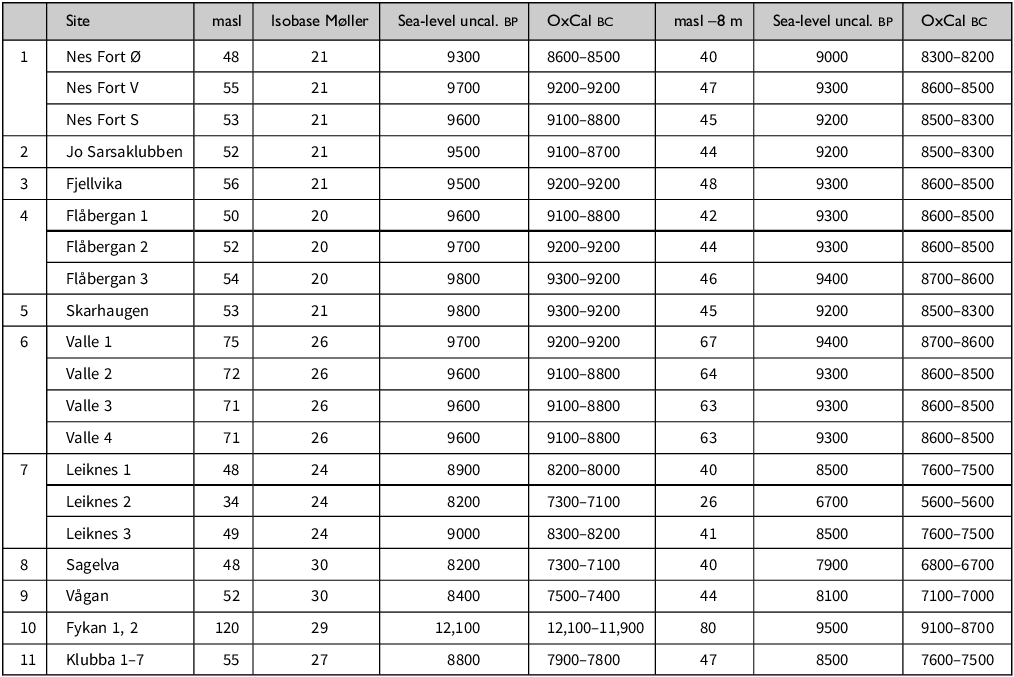
The 11 sites, their current elevation above sea (masl), their isobase and uncalibrated date according to Sealev (Møller & Holmeslett Reference Møller and Holmeslet2002/2012), the calibration of that date in Oxcal v.4.4, in addition to uncalibrated and calibrated dates at 8 m lower elevations. Some sites have several panels with different elevations. For Fykan the second date was set at 8 m below the lake drainage point.

For this study all 11 sites were visited, and the eight northern sites were documented with CPOS (Centimeter POSitioning) equipment in 2023. For the southern three sites we rely on location data from Askeladden, the Norwegian national cultural heritage sites database. We measured the lowest point on the motifs. For Fykan and Klubba, where motifs vary in elevation, we use the measure for the lowest motifs. For Leiknes, we measured the lowest point of the large orca in the uppermost part of panel 1. In other words, we do not attempt to achieve the oldest possible shoreline dates. The elevation was dated according to the geological model providing uncalibrated bp dates. These were then calibrated (Oxcal v. 4.4) without standard deviation, and the resulting dates rounded to the nearest 100 years. It has been customary to subtract 2 m from the measured height to ensure that panels were located above high tide. However, in contrast to middle Holocene rock-art panels for which there is compelling evidence that they were made while in the shore zone (Gjerde Reference Gjerde2010; Tansem & Storemyr Reference Tansem and Storemyr2021), this is not necessarily the case for the ground panels. To counter critique, we have therefore added a calculation for each panel for a shoreline at 8 m below the points measured, which demonstrates that, due to the rapid land uplift in the early Holocene, the dates do not change significantly. The lower measures allow for the possibility that panels were situated significantly above the contemporary shoreline, but without entirely random association between panel and shore.
Hypothesizing the colonization process
Archaeology and anthropology have limited direct information on the processes involved in the colonization of pristine landscapes by hunter–gatherers (Kelly Reference Kelly, Rockman and Steeel2003), and the data available for the Norwegian case is limited to lithic scatters at settlements and the rock-art sites. To further academic debate on the issue, we nevertheless find it useful to hypothesize on the process. The background for the arguments presented here are first of all extensive knowledge of the landscape, seascape and challenges of navigating along the coast of northern Norway. Our visits to sites, in addition to documentation of rock-art motifs and settlement locations, have had an explicit concern with evaluating and reconstructing the past geography.
Ethnographic and ethnohistorical research have provided an important source of inspiration but are not suggested as direct one to one analogies. The cases serve as examples of processes and perceptions. We focus on information from northern maritime hunter–fisher communities in relatable environments, but research based on communities in other settings has also been examined. There is much to suggest that there are significant similarities when it comes to, for example, marking the land (Lovis & Whallon Reference Lovis and Whallon2016a) or acknowledging natural phenomena as agentive features (Bird-David Reference Bird-David2017b; Cruickshank Reference Cruikshank2005; McNiven Reference McNiven, David, Thomas and Creek2008; Westerdahl Reference Westerdahl2005), both within and beyond hunter–gatherer communities. This includes the historical information regarding the reindeer-herding Sámi in northern Fennoscandia. Employing ethnographic information should always be done with great caution so as not to overlook the diversity amongst hunter–fishers past and present. We aim to combine ethnographic inspiration with the specifics of the Norwegian coast and landscape to make a plausible argument for our hypotheses.
Colonizing the coast
The first immigrants entered a pristine landscape with no prior human habitation. From the Swedish west coast and the southern coast of Norway they were familiar with skerries and a rich maritime environment, and for generations they had lived in the vicinity of the ice cap and calving glaciers. However, the steep cliffsides, mountains and long fjords on the Atlantic coast of western and northern Norway constituted a different and unfamiliar landscape. Nevertheless, radiocarbon dates indicate that the entire stretch of this nearly 2000 km long coastal landscape was explored within a few hundred years (Bjerck Reference Bjerck and Fischer1995; Reference Bjerck, Bailey and Spinnings2008).
Maritime wayfinding
There is a range of ethnographic information on hunter–gatherer wayfinding (e.g. Lovis & Whallon Reference Lovis and Whallon2016a). However, most of this is concerned with travel on land, by foot. Transportation by boat allows you to travel longer distances per time unit. But travel on water leaves no direct trails; one is not guided by human or animal paths or tracks as evidenced in forested regions (e.g. Tuck-Po Reference Tuck-Po, Lovis and Whallon2016).
There is extensive academic debate on the cognitive aspects of wayfinding, on the use of allocentric or egocentric descriptions (O’Meara et al. Reference O’Meara, Burenhult, Rothstein and Sercombe2020) and on the importance of cognitive or mental maps versus practical mastery skills (Ingold Reference Ingold and Ingold2000; Istomin & Dwyer Reference Istomin and Dwyer2009; Widlok Reference Widlok1997). These issues will not be addressed directly here. While enskilment linked, for example, to wind directions, currents and other environmental phenomena was no doubt crucial, our focus here is the geographical aspects of wayfinding and the selection of landmarks in a particular landscape: the coast of northern Norway.
The population density was low, residential groups small, and mobility over long distances was necessary to maintain a social network. The pioneer population migrated into unknown territory, and ice and mountainous terrain made travelling by boat a necessity. This meant navigating in initially unknown landscapes with extensive coastlines due to the many islands, sounds and fjords (Norway has more than 100,000 km of coastline, second in the world only to Canada). Long-distance contact and the many sites in the outer coastal areas suggest that a significant part of the mobility took place along the coast rather than between outer coast and inner fjord areas, although the latter were presumably also explored.
The early population voyaging up and down the coast must have sought to distinguish between entrances to long fjords diverting from the main route and sheltered sounds that provided shorter travel routes, as well as avoiding the most exposed and dangerous stretches of sea. They needed to retrace routes, and probably to relocate favourable resource areas, former settlement sites and other significant areas and places. To accomplish this, natural topographical landmarks must have constituted initial reference points. This is in accordance with Inuit knowledge of their landscape, where elders and hunters remember ‘an astonishingly large number of topographical features’ (Aporta Reference Aporta, Lovis and Whallon2016, 70). Traditionally, people from Igloolik were familiar with landmarks along coastlines longer than 800 km (Aporta Reference Aporta, Lovis and Whallon2016, 71) and similar knowledge of extensive areas has been reported from other coastal regions (e.g. Cruikshank Reference Cruikshank2005, 87; Kelly Reference Kelly, Rockman and Steeel2003, 45; Nuttall Reference Nuttall1992; Thornton Reference Thornton1997).
A maritime population must have relied on landmarks visible from the sea. In coastal Norway this could have included distinctive mountain peaks, which is an acknowledged part of current navigation (Den Norske los 2018; Meløe Reference Meløe1990, 77) (Fig. 3). However, as peaks may disappear in clouds, the profile of lower promontories, islands and other conspicuous landscape features (e.g. cliff formations or colourations, river mouths, wide fjords) were likely at least as significant. This is even more pertinent if we take into consideration frequent advection fog caused by warm air from the sea blowing towards the cold air at the ice cap, causing low visibility. On the other hand, the light from the ice cap might have been visible through the fog.
Landscape horizons. (Top) Examples for Tjeldsund and Ofoten from the Norwegian maritime pilot guide (Den Norske los 2008; Norwegian Mapping Authorities); (middle and bottom) landscape horizons between Leiknes and Valle. (Photographs: J.M. Gjerde.)

To memorize and transmit information of routes, resources, and particular locations, ethnographic studies from a vast and diverse corpus point to the use of place names as a primary tool (Collignon Reference Collignon2006; Kelly Reference Kelly, Rockman and Steeel2003; Lovis & Whallon Reference Lovis and Whallon2016a).Footnote 1 These may be descriptive, referring to particular shapes or characteristics of a landscape feature (examples from present-day Norway include Tilthornet/tilted peak and Skarberget/scarred cliff), but could also refer to events or resources (Selbukt/seal bay).
Further mnemonic assistance is typically provided through narratives, incorporating place names and other descriptive aspects of a journey (e.g. Cruikshank Reference Cruikshank2005; Ingold Reference Ingold and Ingold2000). Such narratives could refer to past events, previous journeys or constitute folklore or cosmological myths (Lovis & Whallon Reference Lovis and Whallon2016a). Place names and narratives associated with specific journeys will enable people to know geographical details of, or even to travel in, regions they have not visited previously. In northern hunter–fisher communities, geographical knowledge often covers distances of 500–700 km (e.g. Aporta Reference Aporta2009; Grønnow Reference Grønnow2016; Thornton Reference Thornton1997). In a geographically extensive landscape with a low-density population the exchange of such information must have been invaluable for groups journeying over long distances. As names and stories are passed on through generations, they—and hence the landscape—become ingrained in human being and identity. You associate experiences, memories and social relationships with places in the landscape (Cruikshank Reference Cruikshank2005, 67), creating one or more memoryscapes (Gjerde Reference Gjerde2010, 134–9; Nuttall Reference Nuttall1992).
The animate landscape
For many centuries or even millennia, the population in northern Norway was low density with small residential groups relocating frequently and during a lifetime exploring long stretches of the coast. In such a prolonged colonization process, encounters between landscape, humans and animals play a crucial role. The incoming hunter–fishers depended on acute awareness of their surroundings to survive and organize themselves in the new landscape. The data point to small demographic units. The limited social environment could be expanded and familiarized by including non-human beings. The most obvious new social agents would have been animals who responded to and interacted with this new species (humans). Hence, perhaps, the choice of rock-art motifs. Similarly, landscape, natural phenomena and climate would force, facilitate and invite human reactions and understandings; and humans would explore the landscape, observe animal behaviour patterns and search for raw materials. This setting would arguably encourage a relational ontology. Relational ontologies recognizing the complex patterns of mutual interaction and dependence between humans, animals, plants, things and natural features may be found to a greater or lesser extent in many societies, but are often explicit amongst hunter–gatherers.
The pioneer landscape was initially characterized by a melting ice cap, and the landscape was unstable (Forsberg Reference Forsberg, Barndon, Innselset, Kristoffersen and Lødøen2006). Glaciers were calving with loud cracks, some places causing dangerous waves. The summer meltwater created violent rivers rushing forward, transporting gravel, eroding banks and changing the colour of the sea. Ice-dammed lakes would break up, resulting in sudden drainage and dramatic floods. Due to limited vegetation and unstable climate with regular freezing and thawing processes, land-and rockslides must have been frequent. The melting of the ice cap led to significant land uplift which was accompanied by earthquakes (Lukk et al. Reference Lukk, Leonova and Sidorin2019). The land uplift was pronounced in some areas, changing the landscape within a few generations. In other words, the early Holocene landscape was remarkably active and potentially dangerous.
When encountering such an active landscape the pioneers constantly had to consider its forces. Particularly under circumstances where the number of humans was low, most of their interactions were negotiated with animals and landscape, and presumably some environmental elements were considered animate. Dramatic events may have entered narratives (Cruickshank Reference Cruikshank2005; Taçon Reference Taçon1994, 118) and established the landscape as an active force in their lifeworld. This does not imply that all rocks, rivers or glaciers were sentient beings, but in an ontology where landscape features had this potential, particular contexts and interactions would stimulate such an understanding (McNiven Reference McNiven, David, Thomas and Creek2008).
Phasing and layering
Jarvenpa and Brumbach (Reference Jarvenpa, Brumbach, Lovis and Whallon2016) have presented one of the few ethnohistorical analyses on navigation connected to immigration into unknown territory. They argue for the general possibility of temporal phasing in enculturation of landscapes (Reference Jarvenpa, Brumbach, Lovis and Whallon2016, 34–6). In their case study, the first generations of Chipewyans moving into new territory in the Canadian interior relied on prominent natural landmarks, increasingly using waterways as transport routes. After some generations, more established routes were in place, leaving physical evidence, for example at portages. Later still, as the landscape was becoming familiar and permanently settled, ritual and cosmologically charged sites became an integral part of the landscape. The process covered seven to eight generations, and similar or longer timespans have been suggested in other studies (Rockman Reference Rockman, Rockman and Steele2003, 17).
Acknowledging that the pioneer colonization of a long coast of pristine land must have been a prolonged process, we suggest a similar temporal phasing in the early Holocene landscape of northern Norway, starting with descriptive place names and narratives, proceeding to folkloristic and cosmological narratives and finally marking of a selection of locations with rock art. We link Jarvenpa and Brumbach’s general model of temporal phasing to the specifics of the Norwegian coastal landscape.
For the pioneer population voyaging along the Norwegian coast prior to 9000 bce, certain distinctive natural landmarks would have stood out and become the first anchor points in the new landscape (Fuglestvedt Reference Fuglestvedt2009, 267; Lovis & Whallon Reference Lovis, Whallon, Lovis and Whallon2016b, 3). As such landmarks were repeatedly passed and recognized, they were named, accommodating within and between group references to places, events and routes.
This first phase of exploring, naming and transmitting landmarks is likely to have been multi-generational, possibly lasting several hundred years. As this was unknown and still largely unenculturated land, the first mnemonic narratives were perhaps of the experiences of these journeys, describing the land and its resources. During the first couple of millennia the landscape also changed significantly, as there was a rapid land uplift, causing a change in relative sea-level in northern Norway of up to 55 m between 9500 and 7000 bce. New skerries and promontories emerged; some sounds became fjords. In other areas the rising sea level submerged low-lying areas.Footnote 2 This would have led to the need for adjustments of routes, although many potential landmarks such as peaks and horizon profiles remained the same.
In some ethnographic contexts, hunter–gatherers mark the routes physically, for example with cairns, although these were mostly used if natural landmarks were not sufficiently distinctive (Lovis Reference Lovis, Lovis and Whallon2016, 125). It seems unlikely that there was any need for such physical marking in this pioneer landscape with numerous distinctive landmarks.
As time and generations passed, knowledge of the landscape and its landmarks increased, and the storied landscapes grew dense and layered. As narratives of journeys and events were retold, some of these likely became folklore. While it may have been pertinent to keep details of landmarks and routes correct to maintain navigationally efficient memoryscapes, improvement of narratives through re–telling and alterations could enhance the impact of them as mnemonic devices. In many societies, talented storytellers are highly appraised and may employ their skills to elaborate on the story (Biesele Reference Biesele1993; Ingold Reference Ingold and Ingold2000). A probable sequence in the interaction with the landscape would then have been recognition of particular landmarks, the integration of them in recollections of routes and events, and the elaboration of some of these as folkloristic tales.
Hunter–fisher–gatherers often associate distinctive natural features, such as caves, unusual landscape formations, glaciers, or water (springs, lakes, rapids etc) with mythical narratives and events (Herva & Lahelma Reference Herva and Lahelma2020; Whitley Reference Whitley2024). The active early postglacial landscape along the Norwegian coast would have lent itself to such a scenario. Assuming that the early Holocene population adhered to an animate worldview, we suggest that as part of a long term, multi-generational process some natural features ingrained themselves into cosmological or mythical narratives, a process taking place alongside or perhaps integrated in other narratives making use of distinctive landmarks.
Over generations, layers of human–landscape relations would build up, creating palimpsests of multiple dimensions (Lovis & Whallon Reference Lovis, Whallon, Lovis and Whallon2016b, 4). Placenames for navigational landmarks, resources and events were likely to have been used in different task-related circumstances (long-distance journeys, local resource exploitation, ritual acknowledgements) and could be referred to in a series of partly overlapping and parallel narratives, as individual experiences and storylines diverged (Cruickshank Reference Cruikshank2005, 32–6). Narratives of journeys, events and myths would diversify or merge, and different stories and places would attain primacy in different contexts. The many layers of knowledge building up over time would also provide the landscape with significant time depth, where perhaps certain placenames and elements of narratives would linger on as stable landscape markers in an otherwise rapidly changing landscape.
From wayfinding to rock art
In the Chipewyan case, Jarvenpa and Brumbach (Reference Jarvenpa, Brumbach, Lovis and Whallon2016, 36) found that, while individualistic ritual acts and recognition of powerful forces only involved modest and subtle markings, more extensive marking of the new landscape linked to cosmological and ritual places occurred at a later stage. Similarly, we suggest that the physical marking of certain landscapes with rock art took place in a later phase in the colonization process of northern Norway.
Northern Nordland, where the ground rock-art sites are found, is even today a dramatic and unusual landscape with many steep and smooth rock faces, which would in the past have risen straight from the sea. There are many natural features here that could have served as landmarks.
In Ofoten, several fjords and sounds meet (Fig. 4). One main sound, Tjeldsund, will lead you through the inner parts of this landscape, to proceed on a short and sheltered route further north, whereas other openings are either fjords diverting you from the coastal route or sounds taking you to the outer exposed part of the Lofoten island chain. More than anywhere else along the coast, this was an area where landmarks were required to guide you to a selected route.
The complex landscape of fjords and sounds in Ofoten with rock-art locations. Tjeldsund is the optimal route further north. (Map: J.M. Gjerde.)

The five rock-art sites here referred to as the Lødingen group (Flåbergan, Fjellvika, Jo Sarsaklubben, Nes, Skarhaugen) have very early maximum dates of between 9300–8500 bce (see Table 3), and while they may of course have been made at a later stage, when the sea–level was lower, it is remarkable that all are situated between 50 and 55 masl. It is hardly likely that this identical height across five geographically separate sites would have occurred if they were made much later. If the shore was located 8 m below the lowest part of the motifs, the dates fall between 8700–8200 bce. A map of the reconstructed landscape at 50 masl (Fig. 5) shows that at this height the sites were mostly on islets or small promontories. The rock art was located partly at the entrance to Tjeldsund and partly around Kanstadfjord, which led to a low-lying portage. At 50 masl the portage length was 2 km, with the highest point 15–18 masl.
Reconstructed early Holocene landscape. The blue line indicates the shoreline at 50 m above the present sea level. Red line top left shows possible portage. (Map: J.M. Gjerde.)

As several of the panels are near-vertical and the motifs typically life-sized, it has been suggested that they were visible from a distance. This was tested at the Jo Sarsaklubben panel, where the life-sized reindeer was clearly visible 300 m away from a helicopter hovering at 50 masl, the assumed contemporary sea–level (Gjerde Reference Gjerde2010, 93).
Despite the visibility of some of the motifs if paddling close to the shore, the rock art itself could not have functioned as navigational landmarks. Only Nes was located near the point of the peninsula at the entrance to the key sound, Tjeldsund. The three panels at Nes, however, mostly have a relatively low angle of inclination and the motifs would probably not have been visible from a distance. The other sites are situated either further into a sound or fjord (Jo Sarsaklubben, Fjellvika, Skarhaugen) or slightly behind another promontory (Flåbergan).
While the rock-art motifs themselves were not navigational landmarks, they are all situated in similar and distinctive terrain with naked, light, boulder-like cliffs (Fig. 6). The topographies of these sites are unusual, visible from some distance, and stand out even today. We suggest that these mystic and enticing landscapes would draw people’s attention and lend themselves to narratives.
The distinctive topographies at Flåbergan (top), Jo Sarsaklubben and Fjellvika (bottom). (Photographs: J.M. Gjerde.)

We envision the following temporal phasing in this landscape. (1) The first pioneers exploring the coast would pay attention to significant landmarks to be able to relocate places and retrace routes. (2) As routes were revisited some landmarks were named. (3) This allowed places to be referred to in journey descriptions and other narratives and would assist other groups and new generations to travel in distant regions. Over time, as the landscape became better known, there was (4) a development from the focus on critical waypoints to mystic and enticing landscape features in the vicinity, which lend themselves to dramatic narrative elaboration.
The newcomers had to interact actively with glaciers, meltwater rivers, earthquakes, domineering mountains and animals in this landscape. In animate ontologies, both animals and natural features are often referred to as beings with similar potential for action and sentiments as humans (Bird-David Reference Bird-David2017a,b; Cruikshank Reference Cruikshank2005, 68). Given the active and dramatic landscape in coastal Norway at the beginning of the Holocene, it is likely that from early on selected landscape features became an integral part of narratives. As noted above, the topography of the rock-art sites stands out. The Lødingen group rock art is not placed on even cliffsides but in strongly undulating terrain with numerous levels and what appears as heaps of boulders with ravines and crevices in between. These natural features in a crucial navigational region invited narratives, which at some point became primary to the main landmarks, and the next step could be (5) to mark the narrative landscapes with rock art. In this scenario, the making of rock art is a late phenomenon in the process, elaborating on existing perceptions and narratives.
Over centuries, the pioneers became increasingly familiar with the land, creating palimpsests of layered information consisting of both navigational landmarks, narratives of events, local information and cosmological stories, each to be activated in particular circumstances.
Three other sites are arguably similarly linked to landmarks. Leiknes, locally known as ‘Dyreberget’ (animal cliff) is located on a large, steeply sloping cliffside directly across from ‘Skarberget’ (scarred cliff). The latter has a prominent scar with a different colouration making it visible many kilometres away (see Fig. 3). It is located at the entrance to a long fjord (Tysfjord), which in the early Holocene was a sound exiting close to the site Sagelv (see below). Leiknes is the largest site, and also one of the later sites to be marked (8300 bce at the earliest) and with activity at least till 7100 bce and likely later (Table 3). The site Klubba is located on an island along the outer coastal route, close to the entrance to the fjord, where the spectacular Fykan site is found (see below) and with a view to the island Bolga, still a prominent navigational landmark. Vågan is located below a prominent mountain midway into another long fjord (Saltfjord extending into Skjerstadfjord) and is dated to 7500 bce or later. The three sites furthest into fjords (Leiknes, Sagelv and Vågan) are the three latest sites, which corresponds well with a more active use of inner fjords and sounds from the Middle Mesolithic onwards.
Marking animate landscapes
Several sites with early ground rock art are, however, unlikely to have been associated with wayfinding. Both Fykan and Sagelv are located at the head of fjords. These two sites and Valle are all located in very similar landscapes. To perceive this, it is necessary to consider their past, now lost, topographical context (Gjerde Reference Gjerde2010). At all three sites there are rows of deep furrows in the cliffs (see Fig. 9, below), created by strong glacier advancements during the Younger Dryas (Høgaas et al. Reference Høgaas, Dahl, Smelror, Dahl, Halvorsen, Smelror and Torstensen2022). In addition, there were remains of glaciers nearby, producing meltwater which had to pass through narrow channels before tumbling down rapids to the fjord.
Fykan. (Top) The channel draining the glacier lake in 1907. Most of the rock art is located on the surfaces on the opposite side. (Photograph: Hallström Reference Hallström1938, fig. 28; Gustaf Hallströms Archive, Umeå University Library, Sweden); (bottom) the fall and rapids below the drainage point in 1891. (Photograph: J.B. Rekstad, University Library Bergen, Norway.)

Fykan is found at a past glacial meltwater lake, which drained through a narrow channel before dropping through fierce rapids into the fjord below (Fig. 7). In 1912–1920 a hydroelectric power station was constructed, transforming the landscape. Prior to this, the eminent Swedish rock-art scholar Gustaf Hallström visited the site in 1908 and 1917 and published his impression of the area in 1938:
The magnificent surroundings of these can hardly be described; the days I spent here have left an unforgettable impression. To the west, the fjord hemmed in by its steep rock walls; to the south the glistening, greenish-white expanse of the Fykanvatn, which on the opposite side is bordered by sheer precipices, over the edges of which the Svartisen glacier extends its tongue. The thunder of the Fykanåga never ceased; when the weather was favourable it could be heard all the way to Ørnes, north of the mouth of the fjord. The drift of its current makes itself felt even at a distance of 8–9 km from its outflow in the fjord. (Hallström Reference Hallström1938, 133)
Sagelv in 1908. (Bottom right) The panel with two reindeer; (top right) the channel from the lakes before the drainage point: (top and bottom left) the rapids below the drainage point. (Photographs: Hallström, Gustaf Hallströms Archive, Umeå University Library, Sweden.)

This was clearly a dramatic landscape even then, but in the early Holocene the glacier would have been part of the ice cap with a very strong presence, sending even more meltwater into the ice-blue lake, through the channel and down the rapids. At Hallström’s visit in 1908 the glacier was still visible. Today, a little over 100 years later, the permanent ice is c. 3.5 km away. Before the dam was built the rapids dropped 88 m. In the early Holocene, with a higher sea-level, the drop with rapids would have been much shorter, but in spring and summer the drainage would have more powerful than what Hallström witnessed. The rock art is situated above the meltwater channel, and most of the motifs face out towards the narrow fjord.
At Sagelv the situation was very similar (Fig. 8). A glacier stretching northwest from the Scandes mountain with peaks at 1400–1500 m would have fed a series of lakes, which then drained through a 400 m straight and narrow natural channel leading to rapids dropping into the fjord. The rock art is situated on a steep granite surface in the channel 20 m before the rapids. Here, too, a hydroelectric dam has altered the landscape, but Hallström’s description and photographs help reconstruct the situation. Remains of a glacier are today more than 20 km away.
Valle. (Top) overview of the location; (middle) the many parallel furrows that led meltwater towards a cliff edge; (bottom) panel I on the rockface to the right with the channel in front and the drop further along this. (Photographs: J.M. Gjerde.)

Valle is situated near the mouth of a narrow fjord (Efjord) on the northern side of a range of steep and spectacular peaks (Fig. 9). The terrain is dominated by a series of parallel furrows, as were Fykan and Sagelv. Today the glaciers are more than 30 km away. Here, too, meltwater would have come rushing, passing through the furrows before dropping over a precipice, as it still does in early spring. The panels are located along the furrows.
Nordland County is where the ice cap and isolated glaciers would have persisted close to the coast the longest (Hughes et al. Reference Hughes, Gyllencreutz, Lohne, Mangerud and Svendsen2016, fig. 6), with some glacial tongues extending almost to the fjords even today. On the American northwest coast, glaciers were prominent in many indigenous narratives and were perceived as sentient beings (Cruikshank Reference Cruikshank2005). Glaciers move, they make loud noises, they release ice and water. The rapids thunder, and the gushing water creates strong currents. In postglacial Nordland the land uplift would in addition cause earthquakes (Lukk et al. Reference Lukk, Leonova and Sidorin2019). Even today Nordland is the seismically most active area in Norway, with the strongest quake in Scandinavia in the past 200 years located in the vicinity of Fykan (Bungum & Hicks Reference Bungum and Hicks2002; Keiding Reference Keiding, Dahl, Halvorsen, Smelror and Torstensen2022; Thorsen Reference Thorsen2024).
These highly active landscapes at Fykan, Sagelv and Valle must have drawn the pioneers, not as navigational waypoints, but as animate natural features to pay attention to and perhaps to interact with. We find it likely that natural features at each of these sites were considered sentient beings, and that mythical narratives related to them evolved over time.
As Hallström’s account from Fykan demonstrates, the natural phenomena of meltwater and rapids were noticeable through sound, currents and colouration quite far from the sites. While the sites therefore may have been detected already during early explorations, it is possible, cf. the suggested temporal phasing, that the marking of them with rock art took place at a later stage. Fykan is located highest of all the sites at 150–120 masl, but a shoreline date at 80 m, 8 m below the drainage point, provides a tentative 9100–8700 bce date. Similarly, a point 8 m below the drop at the cliff edge at Valle results in a maximum shoreline date of c. 8700 bce. Sagelv is later, with a maximum date of c. 7300–7100 bce, and as late as 6800 bce if adjusting for a drop of 8 m. This suggests significant continuity in human–landscape relations and narratives.
Cultural and demographic continuity?
The prolonged colonization process we address here spanned c. 2000 years from prior to 9000 bce to c. 7000 bce, and we argue for some continuity in landmarks and human–landscape relations. However, at c. 8200 bce there is a significant shift in lithic technology, associated with immigration from the east (Damlien Reference Damlien2016; Manninen et al. Reference Manninen, Damlien and Kleppe2021; Sørensen et al. Reference Sørensen, Rankama and Kankaanpää2013). Although the data are still sparse, aDNA supports this. Scandinavian hunter–gatherers were genetically a mix between western and eastern hunter–gatherers (Günther et al. Reference Günther, Malmström and Svensson2018), suggesting that a substantial incoming eastern population mixed with an earlier population, primarily deriving from the west.
The genetic mix indicates that this was not a full genetic and demographic turn-over. As there is currently no aDNA from individuals prior to the 8200 bce shift, we cannot exclude the possibility of some earlier interrelations between the eastern and western genetic groups. Such early mixed partnerships would have had greater genetic impact, given an overall low-density population. However, if the genetic impact primarily or exclusively postdated 8200 bce, how might this have impacted human–landscape interaction? And given that some sites are definitively later than the shift, could all sites perhaps be this late?
In our opinion early maximum dates (9300–8500 bce, or 8700–8200 bce if the lower elevation is used) for the Lødingen group sites are convincing. While in principle they may have been made later, it is remarkable that today they are all situated between 50 and 55 masl. Precise dates cannot be reached, but we are persuaded that they predate 8200 bce. Furthermore, the similarities in motifs, execution, style and choice of locations between the early Lødingen group sites and later sites strongly suggests cultural continuity.
It must be considered that the incoming eastern population came primarily over land and would have been dependent on the resident population to learn maritime skills required on the Arctic coast, including wayfinding and landmarks. In contrast to the first pioneers, the eastern immigrants did not arrive in a pristine and unpopulated landscape, so perhaps the processes around 8200 bce involved exchange of knowledge both ways. In this scenario, continuity in landmarks, narratives and at least some mythical landscapes, seems fully possible.
Conclusion
Interpretations of rock art typically concentrate on the motifs. There is, however, an increasing awareness of the importance of the surrounding landscape and topography. Focusing on this latter perspective, we here rely on reconstructions of the pioneer landscape with higher sea levels and an early post–glacial environment to envisage encounters between human maritime pioneers in an unknown geographical region and a series of landscape features and phenomena.
The approach is based on a contextualization of the colonization of northern Norway through archaeological indications of demography and mobility, considerations of required elements in wayfinding and orientation in a pristine landscape, and with the assumption that the pioneers engaged in significant human–landscape relations.
Crucial to our interpretation is that, although the number of sites is small, there is clear patterning in geographical location and local topographical features. Several sites are located in an area where landmarks connected to wayfinding must have been essential and where there is arguably an association between routes, landmarks and the location of the rock art. Knowledge of stable landscape markers in this changing landscape would be a prerequisite in these changing and dangerous landscapes. At least three other sites are situated in particularly active past landscapes, where distinctive parallels in topographical features and associated natural phenomenon indicate that human–landscape interaction was based on a relational ontology and animate landscapes.
Important elements in the prolonged colonization process were temporal phasing of human–landscape relations and layering of landscape information. This long process of familiarization and the associated accumulation of landmarks, placenames, events, activities and narratives arguably resulted in extensive palimpsests of landscape knowledge with significant time depth.
This study with only 11 sites demonstrates variation in the logic behind the choices for rock-art locations. For most prehistoric communities it is probably unlikely that all rock art was made according to one single and coherent schema, particularly since the rock art is usually found across large geographical areas and made over long time spans. However, to comprehend this, more studies must include a larger number of sites and attempt to analyse both landscape and motifs.


 Open access