Introduction
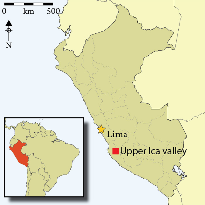
Location map of the Ica valley.

The Upper Ica valley on the south coast of Peru (Figure 1) is an important mining region, where today quantities of copper and gold are extracted by independent miners and multinational corporations before entering the international markets. Here we describe results from a 2010 survey of the Upper Ica valley undertaken to evaluate the importance of these mineral resources to Prehispanic populations and how exploitation may have changed over time to affect the region's geopolitical landscape.
Context
Ancient Andean populations made various uses of the wealth of minerals available to them. Metals (mainly copper, silver and gold) were used as early as the second millennium BC (Aldenderfer et al. 2008; Schultze et al. 2009; Reference PetersenReference PetersenPetersen 2010: 23) to make tools, adornments and religious objects. Various oxides, chlorides and carbonates were also collected and used in a variety of contexts. For example vibrant green, emerald or blue atacamite, malachite and chrysocolla were used for adornments and pigments. Malachite, also called Inca blue, and chalcanthite were used in powder form as offerings during sacrifices (Reference PetersenReference PetersenPetersen 2010: 3 & 7). In the Upper Ica valley these mineral deposits are visible on the surface of hills as brightly coloured seams or exposures. It is therefore not surprising that they were extracted early on by native populations, especially since, according to Petersen, 'the color green was highly regarded by the ancient Peruvians and this was true for gems as well as green rocks' (2010: 5).
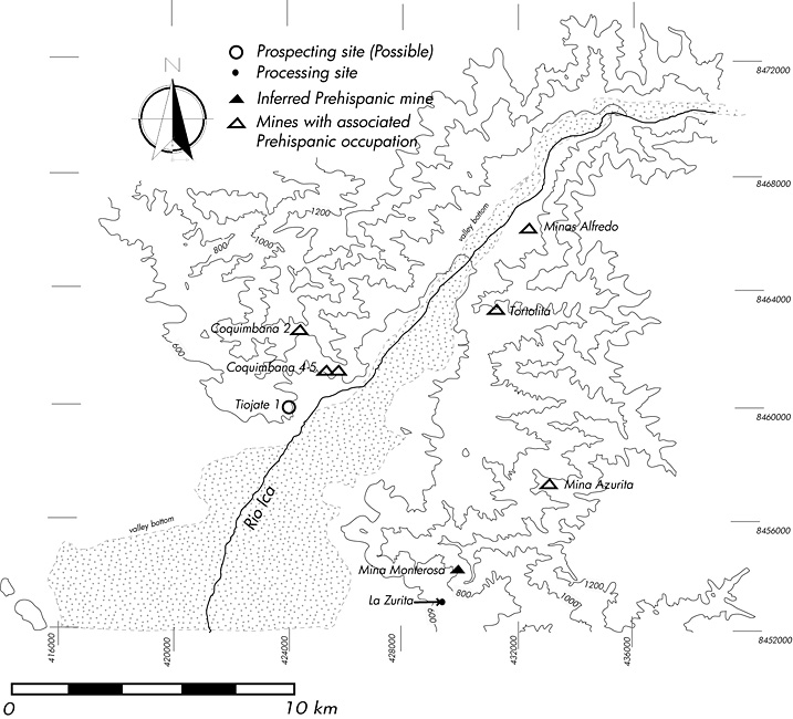
Map of the survey area and sites discussed in the text.

Extraction sites or places where precious minerals can be obtained from the surface are discrete and unique locations in the landscape. For geomorphological reasons their access is often difficult and via a limited number of routes. As the Andean region underwent broad sociopolitical changes, the demand for these minerals increased. We suggest that these locations became endowed with strategic, social, political and economic significance and that access to and defence of these locations have transformed the geopolitical landscape of the Upper Ica valley.
Ancient mining in the Upper Ica valley
Of the contemporary mining site types defined by Eerkens et al. (2009), only smelting sites were not identified in Ica. We found base camps, a possible prospecting site and mines that were used in the Prehispanic period. In addition, we located a site that contains specialised infrastructure for separating gold from copper mined nearby. We briefly describe the most representative sites below (located on Figure 2).
Mines
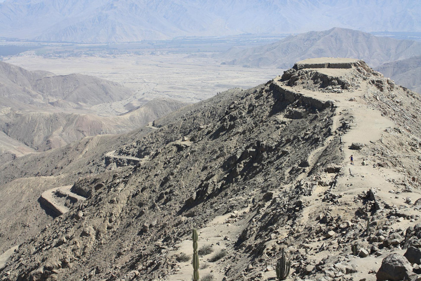
Mina Azurita, looking north-west, with the Ica valley in the background.

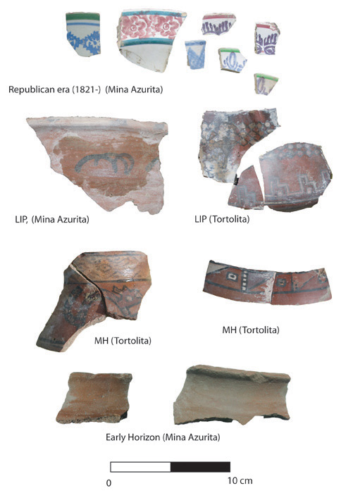
Sample of ceramics found during the survey.

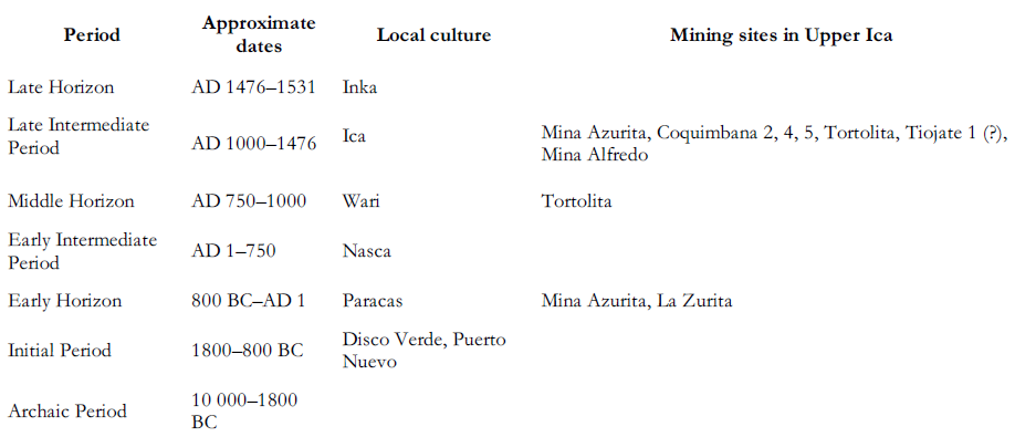
The four ancient mines that we encountered share a number of characteristics. The infrastructure varies from case to case, but all involve large platforms either constructed or made of modified and levelled spaces on high crests or spurs overlooking the extraction zones. All these spaces have been reused by miners until recently. All show ceramic evidence for a Late Intermediate Period (LIP) occupation (Table 1). Mina Azurita (Figure 3), in addition, yielded two fragments dating to the Early Horizon, while Tortolita had scattered Middle Horizon sherds (Figure 4). All these sites offer extensive vistas of the exploitation zone and of the valley below, suggesting they were located to maximise visibility and control of the exploitation zone.

Mining camps
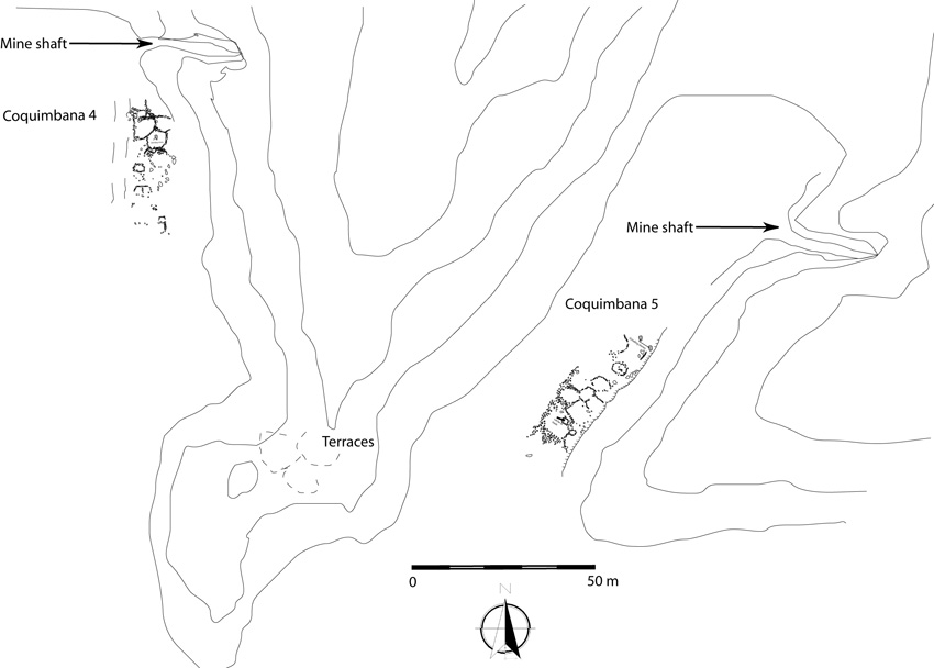
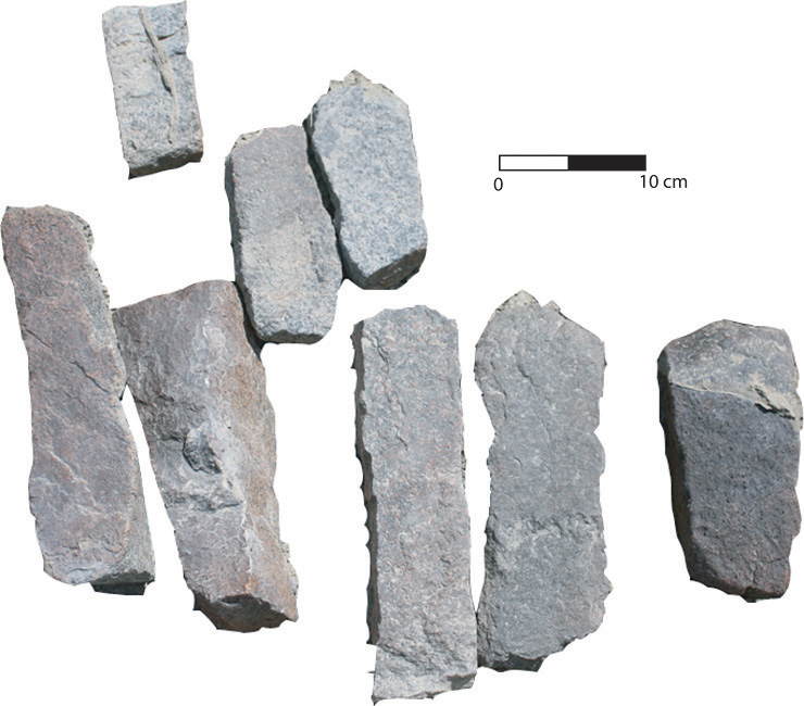
Two small mining settlements (Coquimbana 4 and 5) were discovered less than 200m from each other, on either side of a low ridge (Figure 5). Both are located a small distance from the valley bottom and are directly associated with copper mine shafts exploited until recently. The sites differ from other settlements by the near total absence of ceramic material on the surface. These we interpret as representing a short-term or sporadic occupation coherent with mining camps (Eerkens et al. 2008 & 2009). What little ceramics were found indicate a Late Intermediate Period occupation. In addition, we found on both sites a few grinding stones used to crush raw material. At Coquimbana 5 a small storeroom was littered with fragments of narrow stone wedges or chisels (Figure 6) similar to examples we have found in another ancient mining context (Vaughn et al. 2010) and to those described by Petersen (2010: 36). Towards the edge of the ridge overlooking both sites was a series of small platforms with LIP ceramics that we interpret to be a lookout or a control station.
The mining camps of Coquimbana 4 and 5. The contour lines were based on an air photograph.

Stone chisels and wedges found in a storage structure at Coquimbana 5.

An exploration site at Tiojate 1
Tiojate 1 is located at the bottom of a deep, narrow canyon with a location that maximises control of movement, a short distance west of Coquimbana 45. A single non-diagnostic sherd was found. This canyon is the only access to an extensive network of deep gullies and canyons that are bounded by high and deep crevasses and cliffs. We failed to clearly identify any mines in this area, but some parts of cliffs and hillsides appear to have been partially hacked and burned to spall stone, creating small cavities. We interpret Tiojate 1 to be a prospecting site following Eerkens et al. (2009). Further up the canyon we found LIP sherds and slingstones associated with small natural terraces at strategic passes, but no settlements or structures.
A production site at La Zurita
At the mouth of a gully at the base of a copper mine with a high gold content (Mina Monterosa) there is a group of large boulders with deep channels carved in them: the site was called La Zurita by Reference MasseyReference MasseyMassey (1986). Informants attest that these were used to crush and wash the ore to separate the heavier gold from other minerals. The ceramics here date from the first century AD (Nasca 1/Proto-Nasca), which would make this one of the earliest mined gold processing sites in the Andes (as opposed to alluvial gold panning, the assumed method of exploitation in earlier prehistory). The site may have taken advantage of the strong winds in the lower part of the upper valley, which traditionally played a part in the process of separating gold from impurities (Reference PetersenReference PetersenPetersen 2010: 26). We did not observe evidence for smelting, and the mined gold may have simply been hammered.
Conclusions
What emerges from this study is the temporal consistency of the ancient mining activities. Except for La Zurita, all sites showed an LIP occupation, with little deviation (two sites had associated sherds from other periods, i.e. Early Horizon at Mina Azurita and Middle Horizon at Tortolita).
According to Conlee (2003 & 2004) the LIP on the south coast of Peru is a time when the region reached its demographic peak, and during which hierarchical structure became increasingly complex. Local elites linked by elaborate networks occupied a diversity of social and political positions that were justified and reinforced through various means. Among the strategies they adopted was the control of the production and distribution of utilitarian and prestige goods. In this perspective, few materials would have acquired as much value in the production of craft goods as precious metals and stones. While traditional exploitation of minerals may have been opportunistic and independent, focused on pigments, gems and to some extent metals, the new LIP geopolitical landscape of the Upper Ica valley developed to prioritise new resources, or resources that gained new socioeconomic importance. This triggered increased investment in the defence of mining locations and control of access, extraction and production of metals. It may have also promoted further prospection into hard to reach, sheltered, and seldom-visited canyon networks.
One further observation rests on more tenuous evidence. The only mining site on which Middle Horizon/Wari material was found is located on the north side of quebrada Tortolita, a broad gully that historically has been used as a transportation route to and from the highlands. It is widely accepted that the highland Wari empire profoundly altered sociopolitical formations and models of power in its colonised regions (Reference Conlee, Late, in K.J., Ogburn and ConleeReference Conlee, Late, in K.J., Ogburn and ConleeConlee 2004). Perhaps it is no coincidence that one of Wari's first priorities in the Upper Ica valley was to target the region's mineral wealth. Although Wari control of Ica is an understudied topic (see Reference MenzelReference MenzelMenzel 1964), it is possible that new economic and social models may have affected local populations and led to a newfound interest in an increasingly intensive exploitation of minerals to sustain local elite networks (see Vaughn et al 2010).
The evidence summarised here indicates that the mineral wealth of the Upper Ica valley was well known to ancient populations. Copper, gold and other minerals were exploited as early as the Early Horizon. A sharp increase in scale of exploitation towards the latter part of prehistory corresponds to a time when luxury items acquired a new social and political importance, rendering metals particularly desirable and justifying new efforts to exploit them and limit access to the sources of raw materials.
Acknowledgements
We thank the personnel of Ica's regional Museum and the Instituto Nacional de Cultura for administrative support in carrying out this research, especially Rubén Garcia Soto and Susanna Arce Torres for granting permissions. The National Geographic Society (#8653-09) provided funds for the work described here.