

Introduction
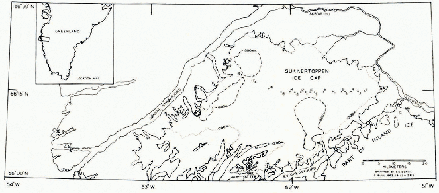
In south-west Greenland, the upland area between Søndre Strømfjord and Evighedsfjord is occupied by the Sukkertoppen ice cap. This has an area of about 2,000 km.2 and most of its surface lies at altitudes between 1,200 and 1,700 m. The Sukkertoppen ice cap is completely separate from the lobe of the main Greenland Ice Sheet which extends westwards to occupy the area south of Evighedsfjord and the lake Tasersiaq (Fig. 1).
Map of the Sukkertoppen ice cap, showing the positions of gravity stations. The 1,200 and 1,600 m. contours are shown only on the ice cap and are simplified from existing maps published by the Danish Geodetic Institute
Glaciological investigations in parts of the peripheral areas have been carried out by four Oxford University and one Cambridge University expeditions (Reference HaywardHayward, 1936; Reference MottMott, 1937; Reference Sugden and MottSugden and Mott, 1940; Reference EtienneEtienne, 1940; Cambridge West Greenland Glaciological Expedition, 1958, unpublished; Henry, 1959; Reference HollandHolland, 1961). Some journeys have been made onto the higher areas of the ice cap, but only observations of a very general nature have been recorded.
In August 1962, three members of the Institute of Polar Studies, Dr. F. Loewe, Mr. H. Brecher and the author, made a two-way man-hauling sledge crossing of the ice cap between a small outlet glacier on its eastern side and a mountain overlooking Søndre Strømfjord, in the north-west (Fig. 1). Subsequently, movement and accumulation stakes were drilled into the unnamed outlet glacier, marked “A” in Figure 1, and an examination was made of the geomorphological features around the western part of Tasersiaq.
The two other members of the party, Dr. S. B. Treves and Dr. J. McCormick, canoed the 120 km. length of Tasersiaq and its north-eastern extension (see Greenland 1 : 250,000 map NQ 21, 22–8, Camp Lloyd, U.S. Army Map Service series C501, 1952), conducting geological, geomorphological and botanical investigations.
Thickness of the Ice
Using a Worden Master Geodetic Meter, values of the acceleration due to gravity (relative to a base at Søndre Strømfjord Air Base) were made at 18 points on the ice cap, at 18 other points on the outlet glacier “A”, and at 9 points on rock around the ice cap. The regional gradient of the Bouguer anomaly across the ice cap appears to be very small, so that ice thicknesses may be deduced from gravity values with some degree of confidence. The method has been described elsewhere (Reference LittlewoodLittlewood, 1952; Reference Bull and HardyBull and Hardy, 1956; Reference BullBull, 1960).
Altitudes of the gravity stations were determined with two Wallace and Tiernan compensated surveying altimeters, readings being taken at all of the stations on both crossings. Indicated altitudes have been corrected for variations in atmospheric pressure (recorded at the Danish Meteorological Office at Søndre Strømfjord Air Base) and for temperature (recorded at the site and at the air base). The maximum difference between corrected altitudes at any one site is 23 m. and the mean is probably correct to ± 30 m.
The cross-section along the traverse is shown in Figure 2. The maximum ice thickness is about 400 m. (stations 3 and 4) and the minimum on the central part of the ice cap is about 250 m. (stations 8 and 14).
Cross-section of the Sukkertoppen ice cap, showing ice thicknesses determined by gravity measurements. Gravity stations are numbered as in Figure 1
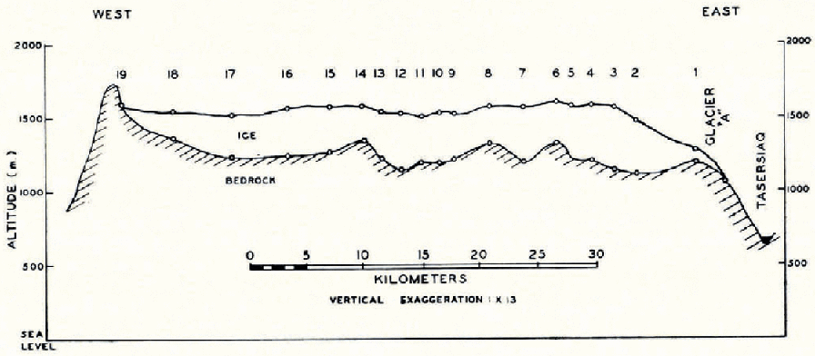
The form of the ice cap surface appears to reflect variations in the altitude of the underlying rock, but the accuracy of the ice thickness determinations is too low to permit quantitative assessment. However, the subglacial valleys at stations 7 and 12 are real, and they are the inland extensions of valleys occupied by north-flowing outlet glaciers.
The local slope of the ice cap surface was measured by theodolite at three points and the corresponding ice thicknesses were calculated from the equation: thickness in metres = 11.3 cosec (surface slope), which assumes that ice is a perfect plastic with a yield stress of 1 bar (Reference NyeNye, 1951). The thicknesses calculated are:

The agreement is excellent and to some extent fortuitous.
It is interesting to compare the ice thickness of the Sukkertoppen ice cap with those of other ice caps of similar size. On the south-eastern lobe of the Barnes Ice Cap (area about 1,000 km.2) Reference LittlewoodLittlewood (1952) found a maximum ice thickness of 467 m. and that the sub-glacial surface was essentially flat at an altitude of 450−500 m. On Vatnajökull (area about 10,000 km.2) Reference HoltzschererHoltzscherer (1954) reports a maximum ice thickness of 880 m.; under a large part of the ice cap the rock surface lies at altitudes between 600 and 900 m.
Annual Snow Accumulation
Pits were dug to a depth of 2 m. and Rammsonde profiles were made to 3 m. at stations 3, 7, 12 and 15, all at approximately the same altitude and in the “soaked facies” in Reference BensonBenson’s (1959) classification. From measured densities and the stratification observed in the walls of the pit, estimates have been made of the annual snow accumulation. Mean values with the number of years reliably identified (in parentheses) are as follows: station 3, 13.2 g. cm.−2 (6); station 7, 16.0 g. cm.−2 (5) ; station 12, 14.9 g. cm.−2 (3) ; station 15, 17.6 g. cm.−2 (8). The annual accumulation increases westwards across the ice cap; this is expected because most of’ the moisture-bearing winds are south-westerly, so that most of the precipitation is orographic and in the coastal (western) parts of the ice cap. Near Mount Atter, in the southwest part of the ice cap and 50 km. from the outer coast of Greenland, the mean annual accumulation for the period 1948–56 was 34.3 g. cm.2 (Reference HollandHolland, 1961), and for the period 1930–38 it was 33.9 g. cm.2 (Reference EtienneEtienne, 1940).
The firn line inland from the outlet glacier “A” is at about 1,400 m. compared with 950 m. near Mount Atter (Reference HollandHolland, 1961) and about 750 m. on small glaciers nearer the coast.
Ice Temperatures
With the equipment available, it was not possible to drill to the depth where the annual temperature variation is negligible. At four stations at altitudes above 1,500 m. none of the temperatures recorded at depths between 3 and 4 m. were below −0 . 5° C., and probably all of the ice cap can be classified as “temperate”.
Periglacial Phenomena
Several stages of glacial recession may be inferred from the degree of weathering, the presence of ice-cored moraines, and the stability of the terminal and lateral moraines around the outlet glaciers at the eastern end of the ice cap. Additional information can be obtained from the well-developed terraces which surround Tasersiaq. The lowest of these (6–7 m.) is almost continuous along 70 km. of the lake edge (personal communication from Dr. S. B. Treves) and was formed when glacier “B” (Fig. 1) dammed the outflow of the lake through Sarfartoq gorge, so that the outflow was over a sill (now 8 m. above lake level) into Evighedsfjord. This was also suggested by Reference MottMott (1937). One of the higher terraces, 20 m. above lake level, is the most extensive at the western end of the lake and was probably formed when glacier “B” dammed the Sarfartoq outlet, and glacier “C” blocked the sill now 8 m. above lake level, so that the outflow was into Evighedsfjord through a second spillway about 2 km. farther north.
Conclusions
The Sukkertoppen ice cap appears to be a fruitful and accessible area for glaciological investigations of a small temperate ice cap. Investigations in the ice-free area between the Sukkertoppen ice cap and the main inland ice should establish the relative chronology of variations in the two ice masses and may be useful in a practical assessment of the response to climatic change of ice masses of greatly differing size.
Acknowledgements
I am very grateful to Dr. Loewe and to Mr. Brecher for their help with these preliminary investigations. The expedition was made possible by grants from the Ohio State University Development Fund and from the Quartermaster Research and Engineering Command, U.S. Army. Transport between the United States and Søndre Strømfjord Air Force Base was provided by the U.S. Air Force.


