


Impact statement
In an era marked by escalating environmental challenges, harnessing the power of collective intelligence has emerged as a beacon of hope. Groundwater, a vital resource sustaining billions, faces unprecedented threats from over-extraction and climate-induced stressors, especially in the arid and semi-arid regions. At this critical juncture, the integration of citizen science (bottom-up) into groundwater level monitoring has ignited a transformative paradigm shift. This paper presents a framework for improving groundwater monitoring by mobilizing farmers in agriculturally intensive regions in North Gujarat, India. The framework developed addresses the gaps and limitations of participatory studies carried out in India and adopts an integrated approach of mapping groundwater levels using data collected by the government and farmers to better understand groundwater behavior, qualitatively and quantitatively. The integrated mapping provides enhanced spatio-temporal coverage and a comprehensive view of the shallow and deep groundwater levels, helping to identify the vulnerable areas. By mobilizing farmers and sharing the integrated groundwater level analysis with the farmers and local water managers, we amplify data collection efforts, empower farmers, strengthen community engagement, encourage responsible pumping and facilitate informed decision-making regarding sustainable groundwater use. As a result, communities are better equipped to respond to emerging challenges, such as droughts, food security and rising water demands.
Introduction
Groundwater has emerged as a primary water source to sustain a significant share of irrigated agricultural production for many countries where limited surface water resources, climate change and rising population are seen as major problems (Rawat et al., Reference Rawat, Singh and Gautam2018). Groundwater is used for over 40% of global irrigation on almost 40% of irrigated land (Siebert et al., Reference Siebert, Henrich, Frenken and Burke2013). However, this irrigation expansion with groundwater has negatively impacted agriculture production and the environment (Zeng et al., Reference Zeng, Xie, Yu, Liu, Wang, Zou, Qin and Jia2016). To assess and manage groundwater resources sustainably, systematic monitoring efforts are needed to measure the groundwater levels and the usage. However, many countries do not have well-developed monitoring systems, and monitoring groundwater levels and usage is very rare, and if it is done, it is either infrequent or discontinuous (United Nations, 2022). Therefore, the low availability of spatial and temporal groundwater data prevents decision-making concerning groundwater that can balance the demand and supply for agriculture and other sectors, particularly in times of scarcity (Chinnasamy and Agoramoorthy, Reference Chinnasamy and Agoramoorthy2015).
This is particularly true for India, which is one of the most agriculture-intensive countries and one of the largest users of groundwater globally (Bhanja et al., Reference Bhanja, Mukherjee, Rodell, Wada, Chattopadhyay, Velicogna, Pangaluru and Famiglietti2017; Hirji et al., Reference Hirji, Mandal and Pangare2017; Chinnasamy et al., Reference Chinnasamy, Hsu and Govindasamy2022). India has an annual groundwater draft of 239 billion cubic meters (BCM), which fulfills nearly 62% of its irrigation requirements (Central Ground Water Board (CGWB), 2022a). Similar to the other countries, the increased reliance on groundwater for irrigation has also caused the exploitation of many aquifers (Gleeson et al., Reference Gleeson, Cuthbert, Ferguson and Perrone2020), particularly in the western, central and southern peninsular parts of the country, which receive average annual rainfall between 100 and 400 or 400 and 800 mm (Central Ground Water Board (CGWB), 2022a).
In response to growing concerns about groundwater problems, the groundwater monitoring organization in India, the Central Ground Water Board (CGWB), currently monitors 16,219 dug wells, 6,338 piezometers and 611 hand pumps across India at quarterly intervals, that is, four times a year during January (winter), May (pre-monsoon), August (monsoon) and November (post-monsoon) (Central Ground Water Board (CGWB), 2022a). While the CGWB provides a detailed assessment, there remain spatial and temporal gaps in the groundwater data at the regional or local level. The high instrumentation and maintenance cost, inaccessibility of the locations, weather extremes and low human resources are some of the reasons for the low frequency and reliability of the data (Chinnasamy et al., Reference Chinnasamy, Hubbart and Agoramoorthy2013). In addition, 70% of these monitoring wells are typically located in the shallowest (water table) aquifer and represent unconfined or perched aquifers but not deeper aquifers (Girotto et al., Reference Girotto, De Lannoy, Reichle, Rodell, Draper, Bhanja and Mukherjee2017). However, groundwater extraction affects the deep aquifers also, as the groundwater levels in many regions of India have gone down, and because of this, the farmers are deepening the wells and tapping water from the confined zones (deep aquifers). Thus, the observation concerning deep aquifers is lacking as only 30% of monitoring uses piezometers in the region.
Against this background, the research is increasingly calling for new monitoring approaches, of which citizen science monitoring has gained a lot of attraction in the scientific community (Paul et al., Reference Paul, Buytaert, Allen, Ballesteros‐Cánovas, Bhusal, Cieslik, Clark, Dugar, Hannah, Stoffel, Dewulf, Dhital, Liu, Nayaval, Neupane, Schiller, Smith and Supper2018; Walker et al., Reference Walker, Smigaj and Tani2021). Citizen science refers to the participation and collaboration of citizens (i.e., non-scientists) in scientific research to generate new scientific knowledge together with professional scientists (Buytaert et al., Reference Buytaert, Zulkafli, Grainger, Acosta, Alemie, Bastiaensen, De Bièvre, Bhusal, Clark, Dewulf and Foggin2014). The idea behind engaging the citizens in the process of collecting data is to tackle the existing issues of insufficient data (Prajapati et al., Reference Prajapati, Talchabhadel, Thapa, Upadhyay, Thapa, Ertis and Davids2021) and also foster additional benefits such as increasing the public’s understanding and awareness of groundwater issues, environmental democracy, strengthened governance and healthier ecosystems (Conrad and Hilchey, Reference Conrad and Hilchey2011; Nigussie et al., Reference Nigussie, Barron, Haile, Lefore and Gowing2018). The current advancements in communication technology, coupled with the increased availability and accessibility of smartphones and the Internet, have facilitated the success and expansion of citizen science initiatives (Brouwer et al., Reference Brouwer, van der Wielen, Schriks, Claassen and Frijns2018).
Citizen science application in groundwater monitoring is relatively recent and growing (Walker et al., Reference Walker, Smigaj and Tani2021; Kirschke et al., Reference Kirschke, Bennett, Ghazani, Franke, Kirschke, Lee, Khouzani and Nath2022). Different stakeholders, such as residents/villagers, school and college students and teachers, women groups and farmers, have been engaged as participants in data collection. Some research has been performed monitoring groundwater through citizen science, such as the Smartphones for Water Nepal (S4W-Nepal) mobilizing a group of undergraduate students to monitor the shallow groundwater levels from the public and private wells in the Kathmandu Valley (Prajapati et al., Reference Prajapati, Talchabhadel, Thapa, Upadhyay, Thapa, Ertis and Davids2021), coastal community stakeholders to monitor the shallow groundwater levels using automated water level loggers in the Bogur Banks, North Carolina (Manda and Allen, Reference Manda and Allen2016), private well owners from the Rocky View County, Alberta, Canada to monitor the groundwater levels of their wells (Little et al., Reference Little, Hayashi and Liang2016), and smallholder farmers participating in observing shallow groundwater levels in Potshini catchment, South Africa (Kongo et al., Reference Kongo, Kosgei, Jewitt and Lorentz2010).
Through different studies involving different participants in the collaborative approach for data collection, farmers are increasingly exhibiting a positive attitude as the depleting groundwater levels directly impact their agriculture production (Beza et al., Reference Beza, Steinke, Van Etten, Reidsma, Fadda, Mittra, Mathur and Kooistra2017; Van De Gevel et al., Reference Van De Gevel, van Etten and Deterding2020). The crop selection depends on the groundwater available for irrigation during different crop growth cycles (Tamburino et al., Reference Tamburino, Di Baldassarre and Vico2020). Some farmers only have shallow groundwater wells, and due to decreasing groundwater levels, they might not have groundwater available for the latter winter and summer periods. As a result, some small-scale and marginal-scale farmers cannot grow crops during the summer due to the non-availability of groundwater (Jain et al., Reference Jain, Fishman, Mondal, Galford, Bhattarai, Naeem, Lall, Singh and DeFries2021)
Thus, citizen science initiatives empower farmers by involving them in data generation, transforming them from passive data consumers to active contributors (Kongo et al., Reference Kongo, Kosgei, Jewitt and Lorentz2010; Van De Gevel et al., Reference Van De Gevel, van Etten and Deterding2020). Some of the research studies engaging farmers in collecting data in India are community-based groundwater monitoring in the watersheds of Gujarat and Rajasthan under the Managed Aquifer Recharge through Village Level Intervention (MARVI) Project (Maheshwari et al., Reference Maheshwari, Varua, Ward, Packham, Chinnasamy, Dashora, Dave, Soni, Dillon, Purohit, Hakimuddin, Oza, Singh, Prathapar, Patel, Jadeja, Thaker, Kookana, Grewal, Yadav, Mittal, Chew and Rao2014), the Water Stewardship Initiative (WSI) by the Watershed Organisation Trust (WOTR) implemented in the villages of Maharashtra (D’Souza et al., Reference D’Souza, Kale and Pinjan2019) and the Participatory Hydrological Monitoring (PHM) pilot project implemented in 500 villages of Andhra Pradesh under the Andhra Pradesh Farmer-Managed Groundwater Systems (APFMGS) project (Reddy et al., Reference Reddy, Pavelic and Reddy2021). Under MARVI, the villagers were trained as Bhujal Jankars (groundwater informed) to monitor and measure the groundwater levels using a measuring tape and reported weekly observations on the My Well App. Similar to this community-based program, the WSI also trained the locals as Jal Sevaks or Sevikas (water volunteers) in Maharashtra to measure the groundwater levels and assist in the formation of a village water management team that would help in better management with the involvement of all the stakeholders. In Andhra Pradesh, farmers (both female and male) were trained in farmer water schools to measure groundwater levels, rainfall and the pumping capacity of the borewells to create groundwater literacy under the APFMGS project.
From these research studies, the farmers expressed that the hands-on involvement not only fosters a sense of ownership and responsibility but also enhances their understanding of local hydrology and the interplay between farming practices and groundwater levels (Maheshwari et al., Reference Maheshwari, Varua, Ward, Packham, Chinnasamy, Dashora, Dave, Soni, Dillon, Purohit, Hakimuddin, Oza, Singh, Prathapar, Patel, Jadeja, Thaker, Kookana, Grewal, Yadav, Mittal, Chew and Rao2014; D’Souza et al., Reference D’Souza, Kale and Pinjan2019). The farmers are becoming more willing to collaborate with scientists and researchers as they feel they contribute to decision-making and help bridge the gap between traditional knowledge and scientific expertise (Reddy et al., Reference Reddy, Pavelic and Reddy2021). Thus, this synergy benefits both parties, as scientists gain access to valuable localized insights, and farmers gain a stronger voice in sustainable water resource management (Kongo et al., Reference Kongo, Kosgei, Jewitt and Lorentz2010; Maheshwari et al., Reference Maheshwari, Varua, Ward, Packham, Chinnasamy, Dashora, Dave, Soni, Dillon, Purohit, Hakimuddin, Oza, Singh, Prathapar, Patel, Jadeja, Thaker, Kookana, Grewal, Yadav, Mittal, Chew and Rao2014; D’Souza et al., Reference D’Souza, Kale and Pinjan2019).
The idea of engaging farmers and expanding the groundwater monitoring network seems attractive, but certain limitations must be acknowledged. First, most of these citizen science studies have been looking into shallow groundwater wells (i.e., unconfined aquifer) majorly located in the village area or its periphery. Thus, the data and information on the deeper groundwater levels and farmers’ private farm wells have been almost limited or nil. Second, the data collected through the citizen science initiatives are stored and analyzed separately, that is, these have not been integrated with the government-monitored wells data. Thirdly, the availability of suitable measurement equipment could be a concern, as not all farmers might possess the necessary tools or resources to conduct groundwater assessments effectively. Many studies have deployed sensors or automated devices where the farmers mostly have to observe the readings and look after the functioning of the meters, while some have provided measuring tapes. Therefore, measuring the levels through measuring tapes might pose challenges in maintaining data quality accuracy, despite the extensive training. Lastly, factors like varying farm schedules, family priorities and weather conditions could lead to irregular data collection, which might hinder the establishment of a consistent and reliable dataset.
Thus, to mitigate these limitations, it is essential to include farmers’ deeper wells in the monitoring network, as the groundwater levels in certain regions have been observed to go below the unconfined aquifer levels. This will also require a more rigorous and effective way to check/validate the observations provided by the farmers, along with more frequent one-to-one communication with farmers to build a long-term dataset. Additionally, one of the main purposes of the collaborative approach is to expand the existing monitoring network and generate a larger dataset; hence, integrating government data and data collected through farmers could help better understand the groundwater dynamics in the region and also help in validating the data collected through the citizen science participants.
Hence, to expand the research on the participatory approach along with addressing the limitations mentioned above, the objectives of our study are (i) to develop a large-scale groundwater monitoring network to enhance the spatiotemporal coverage of the shallow and deep groundwater level monitoring by mobilizing the farmers, and (ii) to integrate the data collected through farmers and government data to understand the groundwater dynamics for better management.
Study area
This research was conducted in two neighboring administrative blocks in North Gujarat, a semi-arid and groundwater-stressed region in western India, namely Patan block (Patan district) and Unjha block (Mehsana district) (Figure 1). The demographic details for the two blocks are shown in Table 1 (Census of India, 2011). Both the blocks experience a semi-arid climate, receiving an average annual rainfall of about 650–700 mm. The blocks are not under drought-affected regions but have been affected by mild drought-like situations in the last two decades (Guhathakurta et al., Reference Guhathakurta, Kulkarni, Menon, Prasad, Sable and Advani2020). The region is underlain with very deep alluvial soil with a major soil texture as fine loamy in the Patan block and sandy loamy in the Unjha block. The original alluvial material has been overlaid by sand brought in by winds blowing through the Kachchh region. Thus, the texture is a mix of fine, coarse, rocky and non-soil. Most of the region’s soils are moderately well-drained, making them highly favorable for agriculture.
Index map and study area location details.

Demographic details of Patan block (Patan district) and Unjha block (Mehsana district) as per Census of India (2011)

The main economic activity in the region is, thus, agriculture, along with livestock rearing. The cropping system comprises food crops, cash crops and fodder crops. In recent years, the main crops grown during the Kharif season are cotton, corn, sesame and groundnut; in the Rabi season are castor, wheat, rapeseed and mustard; and in the Summer season, pearl millet (bajra) and potatoes. Unjha block is the major market for agricultural products such as cumin, isabgol and other spices.
Due to low rainfall and very limited surface water resources in the two blocks, the farmers are highly dependent on groundwater. Groundwater occurs under phreatic and confined conditions and is developed extensively in alluvium through dug wells, dug cum bore wells and tube wells for irrigation and domestic purpose (Central Ground Water Board (CGWB), 2020). However, both blocks have been categorized as overexploited since 2004 (with the stage of groundwater extraction >100%Footnote 1) due to unsustainable large-scale groundwater pumping. The decadal pre-monsoon (May) groundwater levels (2012–2021), as assessed by CGWB, reveal that the groundwater levels have gone down 20–40 meters below ground level (m bgl) in the two blocks (Central Ground Water Board (CGWB), 2022b). Unjha block is smaller in area and population than Patan block, yet both blocks face a similar groundwater scenario of high depletion levels.
This widespread depletion has caused water stress in many villages in the two blocks, leading to the drying up of wells, higher construction and maintenance costs for wells and the energy used for pumping. As per the current groundwater situation, medium-scale or large-scale farmersFootnote 2 do not have an alternative option but to construct a deeper groundwater well in one go. They believe the groundwater level will go further down in the years to come, thereby saving the cost of further investments in the deepening of wells. However, the challenges are inflicted on the marginal and small-scaleFootnote 3 farmers as the construction cost of a single borewell is around INR 10–15 lakhs (~1 million). Thus, many small and marginal farmers cannot invest this much money to construct their private deep well to pump groundwater. So, to get water for irrigating their farms, many small-scale farmers have partnered with other medium or large-scale farmers who provide irrigation water supply. Depending on the capacity of the borewell installed, the number of partners in the region varies from 4–100 farmers. The water is sold/purchased in two ways – either the water seller takes one-third share in the production of the crops for which the water is supplied or charges farmers based on the number of hours of water supply. The price charged varies from around INR 70–250 per hour. However, the economically disadvantaged farmers who cannot access groundwater, either way, are facing issues of crop failures and are forced to either sell their land or become agricultural laborers for other farmers. The situation has become so severe that agricultural prospects in the region could be in danger in the future due to the lack of irrigation water sources (Narula et al., Reference Narula, Fishman, Modi and Polycarpou2011). Therefore, the two blocks are potential study sites to understand the groundwater dynamics and, in the longer run, help farmers in sustainable groundwater and agriculture management.
Data and methods
Baseline survey: Secondary data collection from government-monitored programs
The long-term groundwater level data for 1996–2020 has been collected for ten groundwater wells in Patan block and nine groundwater wells in Unjha block from the Central Ground Water Board (CGWB) through the India Water Resources Information System (WRIS) (http://india-wris.nrsc.gov.in/wris.html). The groundwater levels are monitored quarterly, that is, May (pre-monsoon), August (monsoon), November (post-monsoon) and January (winter). The data series were thoroughly checked for missing or discontinuous data, outliers and repetitive and erroneous values to understand the long-term groundwater behavior. Past research studies show that missing data greater than 30% in hydrological datasets can lead to increased uncertainty and misinterpretation of trends and patterns (Aissia et al., Reference Aissia, Chebana and Ouarda2017; Cordeiro et al., Reference Cordeiro, Vanrobaeys and Wilson2019). Thus, only four groundwater wells in Patan block and four groundwater wells in Unjha block have been considered, which showed less than 30% of the missing values in the total record of 18 years or 72 months duration. The missing values were filled using interpolation techniques.
For 2015–2022, groundwater level data were collected from the Atal Bhujal Yojana (ATAL JAL) Scheme (https://ataljal.mowr.gov.in/Contact/Water_level). Under this scheme, the state department monitors 18 groundwater wells in the Patan block and 22 in the Unjha block. The groundwater levels are monitored twice, that is, pre-monsoon and post-monsoon. This will help compare the groundwater levels monitored by the state department vs the central department for 2015 to 2020.
Primary data collection: Farmers’ participation
Process of village selection
One of the main objectives of this study is to improve the spatial coverage of groundwater monitoring wells. Hence, the villages/regions not covered through government monitoring wells were identified as priority areas. Additionally, all the urbanized areas/urban centers, barren land and non-cultivable land were avoided while selecting villages. After finalizing the villages, a cross-sectional survey was designed to collect groundwater well data from the farmers. The questions for this survey were prepared from the studies by Dhanya and Ramachandran (Reference Dhanya and Ramachandran2016), Limantol et al. (Reference Limantol, Keith, Azabre and Lennartz2016) and Sorvali et al. (Reference Sorvali, Kaseva and Peltonen-Sainio2021) and were prepared in the Open Data Kit (ODK) Android app (Supplementary material S1).
Survey and the sampling process
The survey was carried out during the post-monsoon season (November 2022). A two-stage sampling technique was used in this study. In the first stage, the accompanying local resource person used their social contacts in the village and helped to select the first few farmers having their own private well. The second stage employed the snowball sampling technique, where the first farmer/group of farmers interviewed from the village were requested to link with other farmers. After the farmer had agreed to volunteer to provide the long-term groundwater level observations, the information on their well was to be recorded. In total, a network of 43 farmers, who owning a private well, was established. The measurements for groundwater levels were taken using the 200-meter measuring tape. For the data record, geographical coordinates, time of observation, depth of the well and groundwater depth were stored along with the photograph of the well in the ODK form. Additional information on the year of construction, horsepower of the motor installed, private/community well, water sharing tariff rate, pumping rate and electricity bill were also recorded to know the history and status of the well. Along with this data on soil type and its characteristics, rock type, crop type and cropping pattern, and irrigation methods were also collected to understand the demand and supply for groundwater in the region.
Dissemination of future readings and data quality control
For providing readings, the farmers were trained to measure and record the future observations. The training was conducted individually for each farmer on the first visit. For the first set of readings, the farmers were demonstrated how to use the measuring tape and record the observations. The farmers were then asked to repeat the entire process till they were confident and followed the steps correctly to measure. The farmers’ contact numbers were collected, and they communicated further observations via WhatsApp. The data shared by the farmers are then entered manually into the central database. The farmers were also asked to provide photographs for the observations (while measuring and for the observed reading) to maintain the quality and accuracy of the data.
In order to maintain regularity in recording the monthly observations, an SMS message is sent to the farmers (in Gujarati and Hindi) one week prior to recording the reading, and this is followed up with a telephone call. After the observations are received, they are reviewed as per the previous records, and accordingly, the farmers are contacted/informed.
Data analysis and visualization
The secondary and primary groundwater levels data collected are analyzed for pre-monsoon and post-monsoon trends for over two decades and the year 2022. The spatio-temporal analysis is carried out using statistical analysis and preparing spatial interpolation maps using the inverse distance weight method in QGIS. The factors motivating the farmers towards the participatory approach are evaluated through a set of questions analyzed during the survey and after sharing the evaluation/feedback form (Supplementary material S2).
Results and discussions
Secondary data analysis – Government-based monitoring programs
CGWB groundwater level data analysis (1996–2020)
The groundwater level data, monitored by CGWB, for the Patan block (Patan district) and Unjha block (Mehsana district) were analyzed for five and four groundwater wells, respectively (Supplementary material S3). From the preliminary analysis (Table 2), it can be seen that the mean groundwater levels in both blocks vary between 5.803 and 130.212 m bgl for the pre-monsoon season, 4.023 and 135.269 m bgl for the monsoon season, 4.189 and 125.838 m bgl for the post-monsoon season and 4.592 and 128.344 m bgl for the winter season. The coefficient of variation (CV) is observed to be highest for wells P1 and U2 while lowest for borewells P4 and U1 for all seasons. The high coefficient of variation indicates that the groundwater level in the two wells is highly affected by the drivers like rainfall, pumping and land use change. Seasonally, monsoon season shows high variability in the groundwater levels, which can be attributed to variability in rainfall received in the region.
Descriptive statistics for long-term groundwater levels (1996–2020) in Patan block, Patan district and Unjha block, Mehsana district

Note: CV, coefficient of variation; max, maximum; min, minimum; SD, standard deviation.
The boxplots for the pre-monsoon (Figure 2a) and the post-monsoon groundwater levels (Figure 2b) show a high interquartile range (IQR) for two groundwater wells in Patan block (P1 and P5) and one groundwater well in Unjha block (U1), indicating high temporal variation. The boxplots for groundwater wells from the Patan block (especially P3, P4 and P5) during both periods show that the length of the upper and lower whiskers are unequal. This implies that the groundwater levels do not follow a symmetric distribution pattern. While in the Unjha block, this was observed mainly during the post-monsoon period in U4 and U1 groundwater wells. This behavior can be attributed to variations in pumping volumes following the rainfall for that particular year.
Box plots for long-term groundwater levels (1996–2020) for groundwater well in Patan block (Patan district) and Unjha block (Mehsana district) in m bgl for (a) pre-monsoon period and (b) post-monsoon period.

From the spatial distribution of the groundwater levels for different seasons (Figure 3), it can be seen that comparatively, the groundwater levels were found to be deeper in the Patan block, that is, 16 m bgl during 1996. In contrast, the Unjha block observed groundwater levels at a shallower depth (5–10 m bgl) in the majority of the region. Over the two decades, the groundwater levels have declined in both blocks. The northern region of the Patan block (P4 and P5) and the eastern region of the Unjha block (U2) have seen a decline in groundwater levels of more than 100 m bgl. However, the villages on the border of the two blocks, particularly in the southern part, have seen an increase in groundwater water levels.
Spatial distribution of depth to groundwater levels for the CGWB monitored wells in the Patan block (Patan district) and Unjha block (Mehsana district).

ATAL JAL scheme groundwater level data analysis (2015–2022)
Another set of secondary data for groundwater level was collected from the ATAL JAL scheme. For this, data for 40 groundwater wells (18 wells for Patan block and 22 wells for Unjha block), monitored by both the state and central, was analyzed (Supplementary material S4). While the CGWB wells majorly accounted for groundwater wells tapping groundwater for the shallow aquifer, the ATAL JAL scheme included more groundwater wells (which included dug wells, dug cum borewells and piezometers), reaching the semi-confined and confined aquifers to some extent (Table 3).
Details about the wells in Patan block and Unjha block under the ATAL JAL scheme

The preliminary analysis of the groundwater levels data for the Patan block (Table 4) shows the mean groundwater levels vary from 9.713 to 167.970 m bgl for the pre-monsoon season and 7.850 to 166.708 m bgl for the post-monsoon season. In the case of the Unjha block (Table 5), the mean groundwater levels vary from 5.634 to 187.613 m bgl and 4.719 to 182.962 m bgl for the pre-monsoon and post-monsoon seasons, respectively. The CGWB monitoring program and the ATAL JAL scheme groundwater monitoring reveal that the groundwater levels have gone deeper in the Unjha block (Mehsana district). As per the ATAL JAL groundwater monitoring wells, in the Patan block, 11% of the wells monitored (n = 2) show that groundwater levels have gone more than 100 m bgl, while in the Unjha block, 36% (n = 8) of groundwater wells show a similar trend. Six of these eight wells show groundwater levels have decreased to more than 150 m bgl. Groundwater wells U’6, P’6 and P’5 showed high values of coefficient of variation during both seasons displaying high variability in the groundwater levels. Generally, high variability is observed in the groundwater wells in Patan block, where 50% of the wells (n = 9) in the pre-monsoon and 61% of the wells (n = 11) in the post-monsoon season showed a coefficient of variation >10%.
Descriptive statistics for the groundwater wells in Patan block (Patan district) under the ATAL JAL scheme

Note: CV, coefficient of variation; max, maximum; min, minimum; SD, standard deviation.
Descriptive statistics for the groundwater wells in Unjha block (Mehsana district) under the ATAL JAL scheme

Note: CV, coefficient of variation; max, maximum; min, minimum; SD, standard deviation.
The spatial distribution for groundwater wells under the ATAL JAL scheme (Figure 4) reveals that the Unjha block has groundwater levels observed at 80 m bgl during both seasons. The central region of Patan block is observed to have groundwater levels from 5–60 m bgl. A decrease in groundwater levels was observed in both blocks’ groundwater wells during 2016–2022. In Unjha block, 64% of the groundwater wells (n = 14) show a decrease in groundwater levels during pre-monsoon season (with an overall average decline of 7% or 0.07 m bgl from 2016 to 2022), and 59% (n = 13) of the groundwater wells show decrease during the post-monsoon season (with an overall average decline of 1% or 0.07 m bgl from 2016 to 2022). Of the total groundwater wells, 12 wells (U’1, U’8, U’9, U’10, U’11, U’12, U’14, U’15, U’16, U’18, U’20 and U’21) showed an increase in groundwater levels during both the seasons.
Spatial distribution of groundwater levels for the ATAL JAL scheme monitored wells in the Patan block (Patan district) and Unjha block (Mehsana district).

In the case of Patan block, 44% of the groundwater wells (n = 8) show a decrease in the groundwater levels during the pre-monsoon and post-monsoon seasons, with an overall decline of 6% or 0.06 m bgl and 15% or 0.15 m bgl from 2016 to 2022. Of these groundwater wells, seven wells (P’4, P’8, P’12, P’14, P’15, P’16 and P’17) showed a decrease in groundwater levels during both seasons over the seven years. In contrast, nine groundwater wells (P’1, P’3, P’5, P’6, P’9, P’10, P’11, P’13 and P’18) showed an increase in groundwater levels during both pre-monsoon and post-monsoon seasons.
Primary data analysis – Farmers’ participatory approach
Development of groundwater monitoring network and status of the monitoring sites
In total, a network of farmers was established, and with the active participation of farmers, 43 private wells were monitored (13 wells in the Patan block; 30 wells in Unjha block) (Supplementary material S5). Of these 43 wells, 23% of wells (n = 10) were open wells, and 77% of wells (n = 33) were dug cum borewells or borewells. Of the two blocks, open wells were observed to be more functional (90% or n = 9) in the Unjha block (Mehsana district), while Patan block (Patan district) had very few to almost negligible open wells (10% or n = 1) in functional condition. All the wells were located in the farmers’ respective agricultural farmland and, thus, attributed to groundwater pumping for irrigation purposes.
Hydrologically (Table 6), all the dug wells (100% or n = 10) and five borewells (i.e., 15% of the total borewells) were constructed to a depth of 120 m, that is, up to the unconfined aquifer. Another 24% of the borewell (i.e., n = 8) was constructed at a depth of 210 m reaching the semi-confined aquifer. In comparison, most borewells surveyed (61% or n = 20) were constructed at a depth greater than 210 m reaching the confined aquifer bed. All the borewells are installed with submersible motors, and most have installed motors with more than 50 horsepower to pump groundwater. The high percentage of borewells constructed up to the confined aquifer depth reflects that the farmers are tapping groundwater from the deeper aquifers to irrigate their fields, and hence monitoring these wells is equally essential to know the groundwater behavior and trend.
Details of the open wells and borewells surveyed on the field

Farmers motivation to join the monitoring network
The farmers in the region are well aware of the existing groundwater challenges and the 43 farmers identified had agreed to volunteer in this participatory network on their goodwill. The feedback survey analysis on the farmers’ participation showed that their primary reason for collaborating is their genuine concern about groundwater availability for future years (Figure 5). The farmers mentioned that proper monitoring could help them plan their crops well in advance. The knowledge about the groundwater levels in their region and the surrounding region can also help them decide on the construction of new wells and depth.
Farmers’ response to the reason that motivates them to be a part of this participatory groundwater monitoring approach.

The second reason that motivated the farmers to participate was their inclusion and contribution to local scientific knowledge. This study selected the farmers irrespective of location, gender, cultural norms and socio-economic status. Thus, farmers had a sense of empowerment where their inputs could help in the decision-making on managing the resources. The farmers mentioned that such experiments also help them learn the technical aspects of groundwater behavior and gain valuable information/insights.
Groundwater level analysis using primary data
The primary data analysis of the farmers’ private wells for the post-monsoon season (November 2022) shows that the groundwater levels varied from 12 to 205 m bgl in the Patan block and 4 to 228 m bgl in the Unjha block. The spatial distribution (Figure 6) shows that, on average, the groundwater levels in both blocks are observed to be at a depth greater than 120 m bgl. In Unjha block, 60% of groundwater wells (n = 18) reported a groundwater level of 120 m bgl and 62% of groundwater wells (n = 8) in Patan block showed a similar groundwater behavior. The situation in the northern and north-western parts of the Unjha block is much more critical as the groundwater is available at 160 m bgl. This indicates that the farmers are pumping water from deeper layers to pump water for irrigation. However, this picture of groundwater behavior was not fully represented through the existing monitoring government programs due to low to no deep groundwater well monitoring.
Spatial distribution of groundwater levels for the farmer’s private wells in the Patan block (Patan district) and Unjha block (Mehsana district).

As observed through the CGWB monitored wells for the year 2020 (Figure 3), the bordering region of the two blocks showed groundwater existing at shallower depths and deeper levels in small pockets in the extreme eastern part of the Unjha block and the northern part of the Patan block. This interpolation results from the limited number of monitoring wells in the region. The spatial distribution improves due to more monitoring wells under the ATAL JAL scheme (Figure 4), which shows a slightly different picture from the CGWB spatial distribution. The central part of the Patan block showed groundwater levels at the shallower depth. The bordering region observed groundwater levels of 80–100 m bgl and a small zone of deeper groundwater at >140 m bgl. The spatial map generated through the farmer’s well data (Figure 6) somewhat matched the distribution produced through the ATAL JAL scheme (Figure 4). The Unjha block groundwater level distribution resembled majorly, where the deeper groundwater levels were observed in the northern and northwestern parts and shallower groundwater in the eastern and southeastern parts. In the case of Patan block, as per the ATAL JAL scheme, the groundwater levels were mainly in the range of 10–80 m bgl, while the farmers’ data showed groundwater levels existing at a depth of more than 100 m bgl. Thus, the difference in groundwater behavior observed through secondary and primary data points out the need for an integrative approach to understanding groundwater dynamics for effective management. Additionally, more the number of monitoring locations better the interpolation results obtained to understand the spatial nature of the groundwater levels.
Understanding the groundwater dynamics through integrated mapping
Figure 7 shows the integrated groundwater level data obtained from the ATAL JAL scheme and field survey from the farmers for the post-monsoon season (November 2022). With good spatial coverage in both the blocks, the spatial distribution of groundwater levels shows that groundwater levels have gone down by >100 m bgl in the Unjha block, while in most of the Patan block, the groundwater is available at 100 m of depth. Small pockets of deep groundwater levels exist in Patan block, where groundwater levels have decreased to 140 m bgl. This situation has severely affected the livelihood of many small and marginal farmers in both blocks.
Spatial distribution of groundwater levels developed through combined ATAL JAL monitoring wells and farmers’ private wells in the Patan block (Patan District) and Unjha block (Mehsana district).

Hence, the active participation of 43 farmers in the network and the development of an integrated groundwater level map significantly improved the spatio-temporal coverage of groundwater monitoring in the region. For example, block-level data have been improved to farm-level data spatially and temporally at monthly scales. The data on groundwater levels are now being recorded every month, which were recorded seasonally. In addition, this spatial coverage and inclusion of deep groundwater wells help in a more accurate representation of the groundwater level in the region (shallow and deep aquifer), which was earlier limited only to shallow aquifer.
As a result, the first integrative groundwater level map generated was then discussed with the 43 farmers in our network and the NGOs working on water management in the region. The first and foremost farmers’ observation was that not all farmers have to invest money in constructing a deep tubewell/borewell. The majority of the farmers who are facing issues with existing borewells, when they go for the construction of a new borewell, directly go for the construction of a deeper borewell, which may not be required. However, with the mapping of groundwater levels in their village and the neighboring villages, the understanding of well construction reduces the financial burden not only on the owner but also on the partners in the water distribution for irrigation. Otherwise, the owner tries to recover the construction cost by putting a higher per-hour price to provide water for irrigation to the partners.
Through the integrative groundwater level mapping, it was clear to the farmers in the northern Unjha block that the groundwater levels have dropped significantly (120 m bgl). In order to have sufficient water for irrigation during the winter and summer months, the farmers, in consultation with the local water management team, are opting to cultivate less water-intensive crops such as chickpeas and gram as pilot plots in their farms. Understanding the groundwater availability and then selecting the crop is significantly helping farmers whose regions fall in the deep groundwater levels zone and who do not have their private wells or are unable to partner with other farmers to access groundwater for irrigation.
To manage the groundwater stress in the region, the Dharoi Irrigation Project has been supplying water for irrigation through its right-bank main canal network for the past two decades (Figure 8). However, most of the Patan block villages do not come under this irrigation scheme. Thus, the farmers in this region heavily depend on groundwater for irrigation, as a result of which the groundwater levels have been observed to drop significantly (>100 m bgl). This situation was not reflected in the Central Government groundwater monitoring program due to limited spatial coverage of monitoring and mostly consideration of shallow depth wells. The integrative map, thus, can be useful for expanding the canal network to provide water for irrigation and recharge in water-stressed villages in the region. Alternatively, the information can be used by water management authorities to identify sites to promote/establish traditional recharge structures such as farm ponds, check dams and Holiya structures, especially in the villages of Patan block.
Dharoi right bank main canal network coverage in the study area.

In addition to the groundwater levels data collected, data on soil type and characteristics, rock type and pumping rate are also collected from the farmers. This data, which is groundtruth, can be integrated and updated with the lithology data collected under government programs. Such integrated data can help in building 3D conceptual models to define the groundwater aquifers.
Overall, this study’s participatory approach helps to create a bigger data pool on hydrological, agricultural and geological parameters, and the outcomes can benefit farmers (groundwater awareness), water managers (groundwater management), researchers (groundwater assessment and modeling) aiming to work for better groundwater management in the region. Thus, this work caters to merging the goals of participatory studies such as Kongo et al. (Reference Kongo, Kosgei, Jewitt and Lorentz2010), Little et al. (Reference Little, Hayashi and Liang2016), D’Souza et al. (Reference D’Souza, Kale and Pinjan2019) and Prajapati et al. (Reference Prajapati, Talchabhadel, Thapa, Upadhyay, Thapa, Ertis and Davids2021) and large-scale Indian participatory programs such as APFMGS (aimed at creating a large scientific groundwater database and analysis) and MARVI project (aiming to improve the farmer livelihood and sustainable use of groundwater).
Evaluation of the participatory network/approach
The most significant output of the present research was the effective establishment of the groundwater monitoring network in the region by involving 43 farmers participants in the collaborative approach. While the collaborative approach of engaging farmers for data collection came as empowering farmers and improving groundwater information spatially and temporally, a few challenges were faced while selecting and engaging farmers for data collection. The limited number of farmers participants in the region stems from a complex interplay of factors which are discussed as follows:
-
• Resource-poor farmers or limited mobile handling knowledge: Some farmers interviewed did not have smartphones, while some were not versed in using messenger apps to share monitoring observations and images. As a result of which, such farmers were not able to participate in the monitoring network. Also, in the long term, when the idea is to probably shift to using a dedicated mobile app (such as MyWell) to provide the observed data, some of the farmers were skeptical about using modern technologies and techniques and were apprehensive about participating.
-
• Additional workload: This research focuses on taking measurements accurately, recording the observations by clicking pictures and communicating the same over messages; therefore, the whole process requires training for the same. However, some farmers found it additional work on their already demanding workloads, leading to resistance and reluctance to engage in the process.
-
• Focused on short-term and quick solutions: Some farmers were not keen to participate in the monitoring program due to their not-so-good experience in the past with the existing groundwater issues. The groundwater in the region has gone down so much that some farmers are more focused on immediate solutions regarding the availability and management of groundwater resources. Our research is the first step towards management through improving the region’s spatial and temporal scale of monitoring.
Despite the challenges posed, through this study, baseline data on the deeper groundwater could be generated, which is crucial for understanding the groundwater trend and pattern in the region. The availability of smartphones with the farmers enabled the collection, transmission and quality control of data with ease. This approach’s simplicity, quick learning and affordability/ low-cost nature to measure the groundwater levels helps scale up in other villages and blocks. Thus, the further goal is to expand the network and get more farmers engaged in this monitoring experiment.
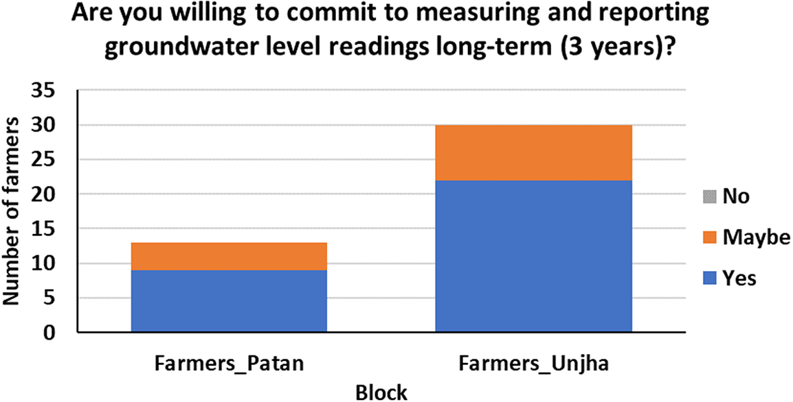
Currently, farmers in the existing network have consistently recorded and reported the groundwater levels to date. About 71% of farmers in the network expressed their sincere commitment to providing groundwater level observations for long-term monitoring extending up to 3 years (Figure 9). The farmers from both blocks are providing monthly readings, but 29% of farmers agreed to provide observations weekly, and 27% agreed to provide on a bi-weekly basis from the subsequent cycle (Figure 10). In the case of the monsoon season, about 57% of the farmers from both blocks agreed to provide observation every week (Figure 11). This positive response from farmers will significantly improve the issues of more continuous data availability to support farmers in the crop production timely and in sustainable manner.
Farmers’ response on the willingness to contribute to long-term groundwater monitoring.
Farmers’ response on the frequency of recording and providing data.

Farmers’ response on the frequency of recording and providing data weekly during monsoon season.

In addition, after discussing the groundwater level integrative mapping, 70% of the farmers in the feedback survey agreed to engage their fellow farmers to join the monitoring, and 50% agreed to train the new farmers on monitoring and reporting the groundwater levels. The farmers in the network realized that if more farmers are aware of the groundwater situation in and near the area, it will be easier for them to switch to less water-intensive crops as a community of farmers. On this positive response to the engagement of more farmers for long-term monitoring, it is thought to incentivize the farmers in some way for their efforts and contribution, which could be providing internet data packs, organizing workshops and felicitating the farmers for their contribution in volunteering, and featuring their contribution on the online website. Additionally, although most of the farmers expressed their comfort in providing observations over WhatsApp due to ease of use, a scope for developing a dedicated mobile app (such as MyWell) for the region can be considered in the future for proper data management.
Conclusion
The present research was carried out in two blocks of semi-arid, high groundwater pumping region of North Gujarat to improve the groundwater level monitoring situation using a participatory citizen science approach. For the baseline survey, the secondary data were collected under two groundwater monitoring schemes (CGWB monitoring and the ATAL JAL scheme). The individual assessment of the government-monitored wells highlighted the gaps in the spatial and temporal coverage and lacked understanding of the deeper groundwater dynamics. For this, the farmers in the region were engaged in developing an integrative map to understand the shallow and deep groundwater scenario. A network of 43 farmers who were trained to measure, record and report the groundwater levels were established. The research team took the first readings on the field, and the farmers communicated subsequent observations through WhatsApp.
The pilot study helped to generate a database for deep groundwater levels which is inevitable for groundwater management in the region. The integrated spatial map generated from the government-monitored wells and farmers’ private wells reveals that the groundwater situation in the Unjha block is comparatively more difficult than in the Patan block. The north-western part of the Unjha block shows that the groundwater has decreased to 120 m bgl due to large-scale pumping for irrigation. The current groundwater situation requires immediate attention as it has affected the livelihood of many marginal and small-scale farmers. Due to limited groundwater availability in the region, many farmers cannot cultivate or grow crops on their land and, thus, have to work as agricultural labor on other farmers’ land. Thus, groundwater data from the farmers’ private deep wells must also be included in the existing government monitoring network to effectively manage groundwater in the region. Based on the evaluation of farmers’ participation in the monitoring program, this study intends to expand the network and engage more farmers to improve the region’s spatial and temporal coverage of groundwater monitoring. The methodology is being further tested and evaluated for better data quality control. In addition, the development of a mobile phone app and a web interface is in consideration for easy and quicker transmission, recording and visualization of the data.
The methodology used in this study can be easily adopted in other blocks or by the watershed management groups focused on groundwater monitoring and can create better ownership of groundwater use. Therefore, this approach can enhance groundwater data availability, address spatio-temporal challenges and provide an effective and affordable regional/localized sustainable groundwater management tool.
Open peer review
To view the open peer review materials for this article, please visit http://doi.org/10.1017/wat.2023.18.
Supplementary material
The supplementary material for this article can be found at http://doi.org/10.1017/wat.2023.18.
Acknowledgements
The authors would like to sincerely acknowledge the Development Support Centre and Cohesion Foundation Trust team for assisting in the field visit and conducting field surveys with the farmers.
Author contribution
Both the authors (P.C. and M.G.) have contributed equally to the conceptualization, writing, data analysis and visualization, reviewing and editing of this manuscript.
Financial support
The authors acknowledge the funding support for the fieldwork from IITB-Monash Research Academy and partial funding for the PI’s time funded by the Programmatic Cooperation between the Directorate-General for International Cooperation (DGIS) of the Dutch Ministry of Foreign Affairs and IHE Delft in the period 2016–2023, also called DUPC2 [DUPC2]; and by the United Nations Educational, Scientific and Cultural Organization – Institute for Water Education (IHE Delft) [2019/089/108483/EWH (GRACERS project)].
Competing interest
The authors declare none.


 Open access
Comments
No accompanying comment.