The island of Sardinia in the western Mediterranean was a renowned supplier of agricultural produce in Punic and Roman times, and was repeatedly hailed by classical authors as the 'granary' of Carthage and Republican Rome. While Carthaginian agrarian expertise in general was equally famous in the classical world, Punic rural organisation and settlement have received surprisingly little archaeological attention (Gómez Bellard 2003). Only in very recent years have intensive surveys begun to document rural settlement in the various regions under Carthaginian colonial control (e.g. Gómez Bellard 1986; van Dommelen 1998; Reference FentressFentress 2001; Botto et al. 2003).
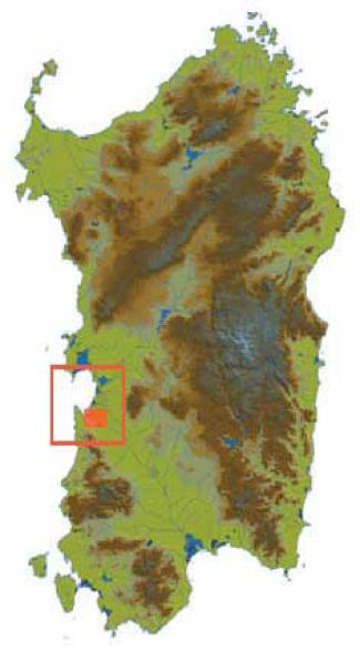
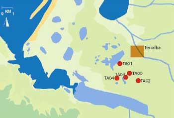
One of these areas is the Terralba district on the central west coast of Sardinia: as recorded by the Riu Mannu survey and intensive amateur research (Artudi and Perra 1997; van Dommelen 2000), the southern part of the former wetlands surrounding the Bay of Oristano was occupied by a remarkably dense cluster of small to medium-sized rural settlements that have generically been identified as farms (Figures 1 and 2). While many of these sites remained inhabited throughout the Roman period, the basic characteristics of the settlement pattern were established in the Punic period (approximately 5th to 2nd centuries BC: van Dommelen 2003).
Location of the study area on Sardinia

Known Punic sites in the Terralba area of west central Sardinia.

Against this background, the Terralba Rural Settlement Project has been set up in order to investigate the composition and organisation of the Punic rural settlement pattern in the Terralba district of west central Sardinia and to gain an understanding of the Sardinian agrarian economy in the wider context of the Carthaginian colonial network.
Fieldwork
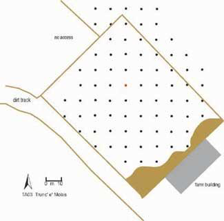
The Terralba project combines geophysical prospection (resistivity and magnetic survey) with intensive surface collections to obtain information about both the lay-out and composition of the rural sites and their fittings and building materials. In order to facilitate comparison of the surface finds with the geophysical data, both the geophysical surveys and the surface collections are based on a 10x10m grid that is set out at each site under investigation (Figure 3). While the former cover the entire gridded area, the latter use the point sampling method that the Riu Mannu survey has shown to be both reliable and efficient (van de Velde 2001). With this technique, all artefacts within a 2m2 area of each grid point are collected and bagged. Any overgrowth at each point has been cleared so that each collection takes place under similar visibility conditions. Diagnostic finds outside these points are kept separately and used for reference only. In this way, a rigorously quantitative and representative sample is generated that can easily be used to produce detailed distribution plots (Annis et al. 1995).
Plan of the grid set out at site TA03.

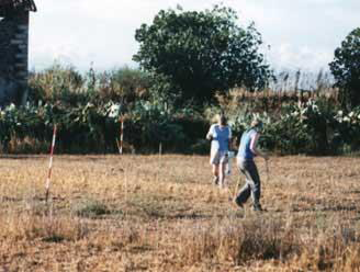
View of fieldwork underway at site TA02.

Because the surface collections inevitably include a large proportion of body sherds that are undiagnostic in conventional typological terms, a fabric typology compiled by the Riu Mannu survey is used to classify all collected sherds (see online report [URL no longer available, checked 2018] and Reference AnnisAnnis 1998). Combining the fabric data with typological information will furthermore throw more light on local patterns of pottery consumption: how much and which types of pottery were produced locally and which ones were imported from which regions?
A total of ten rural sites have been selected for fieldwork and analysis from a database of 131 Punic rural sites compiled by long-term amateur research and corroborated by the Riu Mannu survey (Artudi and Perra 1997; van Dommelen 2003). The selection criteria primarily regard the sites' chronology and conservation: sites which have suffered from deep-ploughing, where overgrowth seriously reduces visibility and those with an Imperial Roman phase are avoided (Figure 4).
Fieldwork results
Five sites were investigated during the first fieldwork campaign in September 2003 (Figure 5). All of these are situated on the so-called 'Terralba sands', which are wind-blown sands overlying Pleistocene fluvial deposits. At 15-20m above sea-level, they rise relatively high above the surrounding wetlands and mixing of aeolian and fluvial deposits has resulted in well-drained, quite fertile soils.
Location of the five sites investigated in September 2003.

Four of the sites studied (TA00-03) had already been classified as settlement sites and this interpretation has fully been confirmed by this year's fieldwork. The fifth site (TA04) has been interpreted as a rural shrine, or more generally a ritual site, because it had yielded an unusually large concentration of handmade figurines. The latter has been included in the sample, because the recent reporting of four similar sites from the Terralba area suggests that rural shrines were a recurrent feature of the local settlement pattern (Reference ZuccaZucca 1998: 134), and because it appeared to be well preserved.
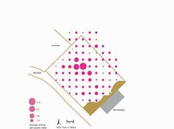
The size of the grids set out ranged from circa 5100 to 6600m2 but the finds scatters measured 3,000 to 4,000m2. Overall, a total of 18,000m2 was surveyed geophysically and 356 grid points were examined. Of the latter, 113 did not yield any finds at all but the remainder yielded 1097 fragments of pottery. In addition, another 429 fragments with notable diagnostic features were collected outside the grid points. On-site pottery densities reached up to 19 fragments per m2.
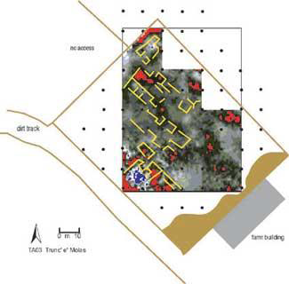
Plan of site TA03 showing the results of the resistivity survey.

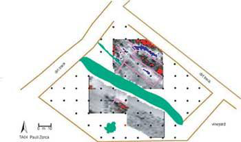
The geophysical investigations proved to be successful in detecting subsurface features at all of the sites, some with more clarity than others. Site TA03 in particular revealed what appears to be a series of building remains clustered on a NW-SE alignment, identified by wall foundation courses. The nature of the geophysical responses suggests that these are of stone construction (Figure 6). At site TA04, similar responses suggest that the subsurface contains remnants of walls revealing a series of buildings again aligned NW-SE (Figure 7). The interpretation of the results remains as yet tentative, as the Sardinian environment is quite different from that usually encountered by the Scottish survey team, but we are confident that further detailed spatial analysis of the geophysical prospection results and the intensive pottery collections will help us to tackle this new geophysical challenge and to interpret the anomalies in more detail. Limited trial excavation may be undertaken to investigate certain of the anomalous areas in depth.
Plan of site TA04 showing the results of the resistivity survey.

The surface finds were classified using a fabric typology that had previously been created by the Riu Mannu survey on the basis of Punic finds from the same region. A total of 1220 fragments were found to fall into one of the 15 fabric categories and the numbers and weight of these were recorded per collection point. All finds with diagnostic features such as rims, decoration, finishing etc. were moreover individually described in detail and drawn if possible: in all, 483 fragments have been documented in this way. Because the bulk of the other 306 fragments that had been collected turned out to be modern products at closer inspection (mostly early 20th century wares and recent roof tiles), this result confirms the validity and robustness of the fabric typology used.
Plan of site TA03 showing plot of raw pottery counts.

Conclusions
The first fieldwork campaign has clearly demonstrated that the combination of geophysical prospection and intensive surface collections offers an efficient way to obtain detailed information on Punic rural settlement. The high quality of both the geophysical and pottery data holds out promising results for detailed spatial analysis, for which the GIS is currently being finalised (Figure 8).
The campaign has also demonstrated the usefulness of using a fabric typology to classify surface finds, because it has been possible to identify practically all sherds. This is particularly significant for the spatial analysis, which can now be based on a substantial database.
Project website: http://www.sardinia.arts.gla.ac.uk/terralba.htm [URL no longer available, checked 2018]
Acknowledgments
The Terralba Rural Settlement Project is generously funded by the British Academy with additional support from the Society for the Promotion of Roman Studies and the University of Glasgow. The local authorities of Terralba, in particular the mayor Gianpietro Pili, as well as Sandro Perra and Gino Artudi along with their friends of the local history association SELAS, have given invaluable practical and logistical assistance to the fieldwork in and around Terralba. Permission for the fieldwork was kindly granted by Dr. Vincenzo Santoni, soprintendente archeologo of Cagliari and Oristano provinces, with the generous support of Dr. Carlo Tronchetti.