


When Charlie Martin, a crane operator, experienced a sharp pain in his lower back, he video-called an emergency physician. Following the physician’s instructions, a paramedic used an electronic stethoscope to assist in the diagnosis. This telemedicine consultation led to Martin taking a urine test, which confirmed a kidney stone. Although reminiscent of the telemedicine surge during the COVID-19 pandemic, particularly among vulnerable groups who preferred to consult doctors online, this episode occurred in the summer of 2010 while Martin was working on an offshore oil platform located in the South China Sea, off Malaysia. The physician was on duty in Houston, Texas. After the diagnosis, Martin was airlifted by helicopter and successfully underwent surgery. About a year later, Martin had another telemedicine experience on the same platform involving an eye checkup. The paramedic used an ophthalmological scanner attached to a scope, enabling the Houston doctor to examine Martin’s eye. It seems that this time no emergency helicopter airlift followed. These telemedicine consultations not only provided immediate medical attention but also resulted in substantial cost savings. Each consultation that avoided a helicopter evacuation saved approximately US$10,000, significantly reducing annual helicopter expenses for certain platforms by more than US$500,000.Footnote 1
The globalization process connecting continents to each other, which can be termed land-to-land globalization, is well documented and explored. However, what I call ocean-to-land globalization – my economic globalization model based on oceanic, not maritime history – seems to have gone unnoticed.Footnote 2 This model focuses on the shift in production sites from land to sea while consumption centers remain predominantly terrestrial. Examples of this connection between Earth’s amphibious transformation and ocean-to-land globalization include offshore oil and gas drilling, mariculture, rocket launching, and offshore wind turbines. Yamashita Tarō’s project of extracting fossil fuels from below the waters of the Persian Gulf to transport them to terrestrial Japan for consumption, giant salmon farms exporting fish globally to meet the rising terrestrial demand for salmon sushi, and offshore wind farms supplying land-based customers illustrate this trend. These examples of ocean-to-land globalization highlight that since the second half of the twentieth century, shrinking transport and communication costs have enabled a spatial separation between offshore production sites and terrestrial consumption sites. This shift marks an important change from the past, when production and consumption sites were typically the same due to cost constraints. Industrialized marine regions delivering goods and services to terrestrial areas emerged when separation gains outweighed separation costs. In this chapter, I therefore focus on Earth’s amphibious transformation through advancements in navigation and communication tools. I address the questions of how and why cost changes in communication and transport spaces through uptake of new radiocommunication and radionavigation technologies influenced ocean-to-land globalization and the proliferation of artificial island use.
Since its embryonic forms in antiquity and its expansion during the sixteenth century, globalization’s acceleration during the Age of Coal altered our perception of the world and connections between different parts of the globe. Decreases in transport and communication costs may intensify trade across long physical distances. However, understanding globalization solely in terms of physical distance, meaning to use distance to conceptualize what “different” parts of the globe are, is deeply rooted in a terra-centric worldview. Globalization is oversimplified if, spatially, it is seen as intensifying trade connections between multiple continents or, considering the arbitrary boundaries that humans created when they separated land masses into continents, as intensifying trade connections between multiple terrestrial sites very distant from each other in physical space.Footnote 3 Still, spatial examples of globalization, such as the so-called Silk Road, the Atlantic triangular slave trade, or the Manila galleon trade, are overflowing with terra-centric ideas that production and consumption sites located thousands of kilometers apart came into quite regular contact, forming the “globe” by connecting continents. A more nuanced approach considers globalization as the result of changes in relational space, examining how decreasing cost barriers have influenced the creation and growth of production and consumption sites, irrespective of their physical distance from each other. The relative distance in transport and communication spaces, rather than absolute physical distance, sheds light on the process of new offshore production sites, such as oil, salmon, or rocket launches, beginning to interact with consumption sites. The extension of the built environment to sea surfaces, starting in the Age of Oil and strongly linked to civilian use of radio technologies, enabled ocean-to-land globalization. This very important connection between energy transitions and advances in radio communication and navigation, which lowered costs for civilian users, is further illustrated by, for example, solar cells powering communication and navigation satellites as one of the early applications of renewable energy.
Transport and communication costs refer to the economic burdens on users for utilizing specific technologies. They include expenses such as purchase, maintenance, and often salaries for skilled personnel. In contrast, research and development costs were not necessarily a concern to civilian users or manufacturers, in cases where already available military technology could be adapted to civilian contexts. It is also important to note that, economically, offshore transport costs have a different character than their on-land counterparts, which primarily involve the movement of goods and people, not the immovable terrestrial built environment. Sustainable mobility, introduced in the previous chapter, enables the relocation of floating structures and the investment capital fixed in them. The lifecycle costs of these mobile, floating structures should be divided into lifecycle costs in the usual terrestrial sense (construction, maintenance, demolition) and the costs of transporting these structures to their production site or relocating them. Transport costs thus encompass this form of movement and the circulation of vehicles (helicopters, boats) between the structure and other locations. In essence, transport spaces becoming more efficient had a stronger economic impact on facilitating ocean-to-land than land-to-land globalization. In contrast, lifecycle costs in a terrestrial sense are not the object of investigation in this chapter. They varied dramatically according to the type of artificial island and usually were much higher than communication and navigation costs but were still subordinate to them. Without communication and navigation technologies, no large-scale placement of artificial islands beyond visual range from coastlines would have happened in the first place, as it would have been too dangerous and unproductive. I therefore do not engage here in more general lifecycle cost comparisons between production sites located on sea surfaces and on land. Yet, generally speaking, operating in increasingly rougher waters usually added to construction and maintenance costs.
Quantifying, not only qualifying, the declines in communication and transport costs is crucial for understanding ocean-to-land globalization. These decreasing cost barriers to trade and socioeconomic development, along with political decisions, have been instrumental in shaping the onset of the oceanic Anthropocene. The reduction in these costs since the mid-twentieth century, over approximately eighty years, suggests that ocean-to-land globalization is likely to intensify further, with an increasing number and variety of offshore production sites. Building on the previous chapter on cybernetic networks, this chapter more explicitly explores the impact of cost drops on sea surface habitation, leading to new geo-ontologies among users of communication and navigation systems. Historian William Rankin’s recent work on cartography and navigation highlighted new geo-epistemologies in the twentieth century, referring to novel ways and tools for cognitively understanding geographical space – or the “difference between knowing your neighborhood through detailed stories, a pictorial guidebook, a map, aerial photographs, the coordinates of a GPS [Global Positioning System] receiver, or simply walking around.”Footnote 4 Studying the validity or social uses of different tools for knowing geographical space is indeed interesting and part of this chapter. However, applying an oceanic-vertical perspective, my primary interest remains in geo-ontological perspectives.
From a geo-ontology viewpoint, material conditions and knowledge mutually affect each other to create conceptualizations of the world, resulting, for example, in terrestrial or amphibious mindsets. Expanding on Chapter 3’s theme of placemaking, I address different ways of categorizing spatial relations, which have changed through technological advancements, as has the geo-ontological understanding of Earth’s centers and peripheries of production. Categorizing space according to material conditions therefore played an important role in the geo-ontologies of users when technologies of terrestrialization, such as steam pumps, railways, hydroelectric dams, or concrete, radically changed the personal impacts of these conditions. The Age of Coal contributed to globalizing the Western geo-ontology of the world, viewed as formed by continents – large landmasses separated by water whose interiors were now being opened up by railways – and using energy-intensive technologies of terrestrialization to transform wet or amphibious spaces into dry land. This terra-centric geo-ontology in the form of the terrestrial mindset intensified spatial hierarchies of regional and local accessibility and remoteness, associating centers of production with terrestrial material conditions and relegating marine regions to the status of almost empty, remote peripheries. However, I show that technological advancements in navigation and communication since the mid-twentieth century have strongly transformed interaction with sea surfaces and therefore, for users, changed the spatial arrangements of accessibility and remoteness. In other words, ocean-to-land globalization since the Age of Oil has elevated part of the oceanic environment to a much more central role in these spatial arrangements. I draw on historian Richard White’s point that engaging in productive work, particularly physical work, “offers both a fundamental way of knowing nature and perhaps our deepest connection with the natural world.”Footnote 5 However, I explore the geo-ontological changes not limited to work-related experiences. Despite the important role of work, the technology-enabled cybernetic extension of human senses encompassed all aspects of human life on sea surfaces, leading to new forms of interaction with and within the oceanic environment. The civilian proliferation of navigation and communication technologies after World War II implemented, among users, a continuous geo-ontological shift toward conceptualizing sea surfaces as inhabitable places and certain marine regions as non-terrestrial centers of production in the amphibious human habitat.Footnote 6 In the previous chapter, Tange’s and Fuller’s Tokyo Bay projects were unrealized. However, the ongoing IT revolution, a continuation of the cybernetics boom, albeit without its biological vocabulary that is helpful for understanding technological adaptation to environments, has provided the technological infrastructure for these cost declines. The increasing ability to inhabit sea surfaces, in ways similar to terrestrial regions, is intrinsically linked to the decline in costs and functional improvements of communication and navigation technologies.
The Stages of Ocean-to-Land Globalization
In this chapter, I argue that the revolution in communication and navigation technology was essential for Earth’s amphibious transformation and its process of ocean-to-land globalization. This revolution removed disparities in communication and navigation between terrestrial and marine regions. To understand the geo-ontological shifts in world perception, it is crucial to analyze the extensions of senses or their novel creation, as the involved communication and transport technologies were deeply intertwined with the material conditions of space. A basic example is the differing properties of air, ground, and water, typically resulting in the use of radio waves, cable infrastructures, and acoustic waves, respectively. From a cybernetic viewpoint, modifying interactions with sea surfaces, like through land reclamation, radically changes the space’s material conditions, enabling interactions typical of terrestrial spaces. However, this approach obviously does not involve extending or creating new senses due to oceanic material conditions. In contrast, extending audiovisual senses offshore through satellite-enabled videocall telemedicine creates a situation akin to physical proximity between doctor and patient without large-scale physical space alterations. GPS and its predecessors created a new artificial sense of orientation. Studying the increased capabilities in connecting communication devices on offshore production sites to other locations or applying position-fixing aids at sea therefore moves us beyond a terra-centric geo-ontology. I demonstrate that the drop in communication and navigation costs enabled humans to cybernetically extend and modify their senses, changing their sea surface inhabitation capabilities. Radio technology, specifically radio wave–based communication and navigation, played a key role in these geo-ontological shifts among users. Radio technologies were the essential enablers for conceptualizing industrialized marine regions and their built environments as new centers of ocean-to-land globalization. Unlike media ecology studies that focus on the dematerialization of communication flows through radio waves, I am still interested in material objects, like computers and satellites, and their role as tools in adapting human senses to oceanic material conditions through sense extension or creation of new senses. This focus is somewhat similar to Nicole Starosielski’s in her book on undersea cables and the materiality of the oceanic environment.Footnote 7 In my case, the trajectory of wireless radiocommunication and radionavigation technology advancements shows that the volumetric space where higher-frequency radio waves operate without strong distortions, namely the atmosphere above sea surfaces (unlike the massive distortions in saltwater), delineates the boundaries of Earth’s amphibious transformation in users’ minds. The reach, cost, and availability of communication and navigation tools such as transmitters and receivers shaped conceptualizations of oceanic communication and navigation centers, peripheries, and dead zones, as well as communication and transport space transitions. Investigating these transitions, the material conditions, and political decisions that shaped technology research explains the former differences in communication and navigation temporalities between terrestrial and oceanic regions.
The marine regions investigated here as production sites in ocean-to-land globalization were selected based on the importance of the communication or transport space transitions that originated in them or by which they were profoundly transformed. Seen from a radio wave–based communication and navigation technology point of view, marine regions share very similar material conditions above the sea surface, meaning that a spatial transition at one site was usually representative of a global development, although these transitions (like energy transitions powering them) varied locally in intensity and pace.
Investigating ocean-to-land globalization blurs the imaginary divide between biological and artificial communication systems, both crucial for operating and controlling human interactions within ecosystems. Like the light islands discussed in Chapter 3, the cost reductions and new radio technologies, on a micro level, fostered a new geographic subjectivity and a sense of place among users, and on a macro level led to a geo-ontological shift toward an amphibious human habitat. In other words, the shrinking differences between inhabiting sea surfaces and terrestrial sites, or the growth of an amphibious geo-ontology, corresponded to the technological trajectory that began with humans sensing oceanic environments only through biological senses such as sight and hearing; leading to sense extensions through radiocommunication technology that transmitted sounds, such as Morse code or voice; creation of electronic orientation senses through virtual coordinate or direction overlays onto the physical world; remote sensing capabilities enabling tracking of offshore locations of vessels and other vehicles; and telepresence, as in telemedicine, videocalling, and remote control of machines, extending audio-visual and tactile senses. For users, these forms of artificial sense extensions or creation of new senses diminished terra-centric perceptions of oceanic remoteness.Footnote 8
After World War II, the first stage of ocean-to-land globalization emerged, enabled by wartime advancements in military technology and postwar low-cost sales of military equipment. Radio communication technology detached socioeconomic interactions from geographic proximity, creating additional connections in marine regions that previously were characterized by extremely low and expensive data rates unsuitable for industrial purposes. However, communication costs declined slowly, and sea surfaces remained communication peripheries despite increased functionalities. In the aftermath of World War II, radionavigation and position-fixing advancements also reduced transport costs. They solved the problems of terra-centric navigation systems in finding offshore sites, allowing vessels to accurately fix positions in a cybernetic coordinates overlay on the physical world and to return to these points. For users, such electronic coordinates overlays caused a geo-ontological shift, similar to the light islands discussed in Chapter 3, resulting in placemaking by marking genuine offshore destinations and sites of departure due to the extension of the built environment onto the sea surfaces of industrialized marine regions.Footnote 9 Vehicles like helicopters, rockets, ships, and boats utilized communication and navigation tools to reach, leave, and interact with these artificial islands, in the process causing the geo-ontological changes among users.
The second stage of ocean-to-land globalization emerged in the 2010s. The declines in communication and transport costs created synergies, such as permanent position tracking, that improved productivity in existing industries and enabled a multitude of new offshore industries. GPS and high-speed satellite internet were instrumental in these spatial transitions, facilitating the adaptation of new forms of ocean industrialization to the material conditions of marine regions, from frequent offshore rocket launches and landings to smart fish farms and autonomous vessels.
A spatial transition means a gradual change from one order of communication- or transport-related space to a new one. Space was not annihilated by time, nor did old spaces completely vanish in a transition, such as from radiotelegraphs to radiotelephones. New spaces also did not necessarily have the identical geographical reach as previous ones. While older spaces lost active users, they often remained relevant for emergency or backup use. Communication and navigation technologies serve to connect two or more sites in time and space. In each new transition investigated here, they reconfigured the relationship between such sites and enabled a transition to a more affordable, faster, or more functional space. For example, the introduction of fossil fuel–powered transport and communication technologies greatly changed the corresponding communication and transport spaces. The time required to communicate between two sites indicated whether actors perceived one or both to be located in a communication center, periphery, or dead zone. Similarly, the time to travel between two sites indicated centers and peripheries in transport space. Consequently, changes in oceanic time regimes created by new technologies enabling regular and standardized communication exchanges with offshore production sites or by navigation-related tracking and regular revisions of estimated arrival times caused conceptual changes among users concerning a marine region’s centrality or remoteness.
The importance of time in shaping such spaces, which are defined by speed, becomes evident when compared to geographical space, as historian Ronald Wenzlhuemer has pointed out.Footnote 10 In geographical space, the speed of a connection is not the main concern, since the distances (like nautical miles) that define this type of space only roughly indicate the time needed to traverse them. Regarding ocean-to-land globalization and the separation of production and consumption sites, the critical point is that certain marine regions, despite their proximity to the coast, transitioned from “remote” to “accessible” only due to significant reductions in communication and transportation costs. Previously, material conditions like regular fog or heavy rainfall rendered them very inaccessible to human senses, reducing speed.
Offshore Communication and Navigation in a Longue Durée Perspective
Applying an oceanic-vertical perspective to economic globalization reveals the undertheorized role of offshore production sites. I first provide a brief longue durée analysis of the cost declines and increasing spatial separation between terrestrial production and consumption sites, after which I contrast the different temporalities of transport and communication space transitions at sea and on land. While economist Richard Baldwin’s study on communication networks and economic globalization is very inspirational, it considers the ocean as a mere connector between terrestrial sites, in line with traditional maritime history. However, his insights into the stages of land-to-land globalization, driven by diminishing costs of moving goods, ideas, and people, are invaluable. For example, in the hunter-and-gatherer era, production and consumption sites were not separate, as nomads consumed resources where found. After the Neolithic Revolution (or first agricultural revolution), production and consumption mostly remained localized, as people became sedentary at the sites of agricultural production. Production therefore was generally limited by local consumption, if these demands were met at all, with trade volumes remaining low even during the sixteenth century and beyond. Baldwin identifies a major shift in the first half of the nineteenth century with the advent of steam power in shipping, which drastically lowered transport costs, initiating the first stage of globalization by increasingly separating terrestrial sites of production and consumption. This separation contributed to the Great Divergence between the West and other countries, spurred by a combination of greatly reduced transport costs and still high communication costs, fostering a cycle of industrialization, agglomeration, and innovation in the global North, where productivity surged. Conversely, viewed on a macro scale, the global South predominantly became a consumer of goods whose production in the global North and shipping to the global South became less costly than production in the global South for local consumption. The second cost constraint caused this particular outcome. Despite communication technology advancements like the telegraph, communication costs remained relatively high, constraining ideas exchanges to the North. It was not until the second half of the twentieth century, especially with the 1990s commercial internet revolution, that communication costs dropped immensely, removing this constraint on the separation of production and consumption sites. Companies from the Global North decided to capitalize on the lower labor costs in the Global South more intensively, resulting in the second stage of land-to-land globalization. The lower labor costs were no longer offset by the high costs of communicating with and coordinating the new sites of production in the Global South. The early public internet, for example, cut messaging costs to almost zero and enabled transfers of comparatively large volumes of digital data instead of physically transporting hard drives. The World Wide Web introduced features previously unavailable through communication technology, such as hosting and remote information access. Additionally, capital movement across borders became less costly through digitization, a process already legally eased by the breakdown of the Bretton Woods system in the 1970s. Baldwin, however, notes that the relatively high costs of moving people, as the third cost constraint, still influenced which countries of the Global South, like China, became new production centers, primarily those in geographical proximity to the already industrialized regions of the Global North, such as Japan.Footnote 11
Baldwin’s macroscale model is insightful but limited when applied to smaller, historically detailed scales, especially considering political, social, and cultural factors. It shows aggregated national tendencies while excluding local communication peripheries that continued to exist within both the Global North and South. Moreover, the model is biased toward terrestrial geography, contrasting with my ocean-to-land globalization model that considers the distinct conditions of marine regions, therefore serving as a necessary complement to terra-centric models in an amphibious world. Nevertheless, Baldwin’s framework aids in analyzing ocean-to-land globalization.
Returning to the ocean, twentieth- and twenty-first-century advancements in communication technology shifted many marine regions from communication dead zones to communication centers. For millennia, the material conditions of marine regions resulted in a periodization of communication possibilities very different from settled terrestrial regions. Oceanic remoteness and isolation stemmed not from geographical distance but from differences in communication temporalities, which were caused by the choice of specific communication media use and structural limitations due to material conditions and political demands. Historian Harold Innis argued that since antiquity, communication media have supported long spatial reach and/or information storage over extended periods of time, thus shaping civilizations.Footnote 12 In marine settings, neither goal was effectively achievable for millennia. For example, in antiquity, terrestrial stone buildings served as time-focused media, among them pyramids and ziggurats whose wall writings had a very limited communication reach but served to store information over very long periods of time. In contrast, the water-located buildings of ancient Southeast Asian civilizations, made of wood and bamboo, succumbed to water movements and weather conditions. These conditions meant that the Southeast Asian architectural style could not turn these ephemeral, amphibious or floating structures into time-focused media.Footnote 13 Terrestrial communication media, including oral traditions from all over the coastal world, preserved myths or historical details about certain marine regions, including marine and bird species, currents, wave patterns, seabed sediments, and other details that supported fisheries and navigation.Footnote 14 Yet the lack of ocean-based, time-focused communication media contributed to the perception among terrestrial civilizations that marine regions lacked their own history. In contrast, the second media type, space-focused media, were characterized by geographical reach instead of durability. For example, sea charts could easily be circulated between ports and anchoring ships or between ships encountering each other. However, they did not extend the communication reach of a ship on the ocean, which remained socially isolated beyond its audiovisual range. The invention of radio technology in the late nineteenth century, however, revolutionized marine communication. The introduction of a space-focused media adapted to oceanic conditions enabled previously unconnected communication dead zones to connect with other sites where radio equipment was present. One offshoot, radionavigation, accomplished the same revolutionary change in transport efficiency through more accurate position fixing and navigation.
This late nineteenth-century innovation resulted in a new oceanic communication temporality as pivotal for human interaction with the ocean as the Neolithic Revolution was for terrestrial civilizations. The Neolithic Revolution marks the beginning of terra-centric sedentary lifestyles, rooted in agricultural food production and with production and consumption sites almost completely overlapping. One factor caused by the Neolithic Revolution was the use of script-based communication media for community-creating religious and administrative purposes. These communication media, among them ancient Mesopotamia’s and Egypt’s clay tablets, stone writings, and papyri, served to govern farming communities that had grown beyond the size of small cities. In combination with other factors, they enabled the emergence of larger political entities, whose sizes were influenced not only by media durability but also their spatial reach.Footnote 15 Communication cost decreases thus resulted in some spatial separation between production and consumption sites. Fast-forward to the nineteenth century, what I call terra-centric, sedentary communication technologies like wired telegraphs were designed to link immovable sites where substantial amounts of capital were fixed and whose locations were precisely known. But they could not adapt to marine conditions. Unlike radio waves, these technologies, spatially far-reaching between specific points, could not provide a network connection at any point within a large area. For example, nearly 99 percent of transoceanic digital communication in 2010 relied on communication cables located on or below the seafloor, ironically connecting fixed points across different continents but not mobile sites in marine regions.Footnote 16 Contrastingly, advances in radio-based wireless technology offered an amphibious, mobile alternative to terra-centric, sedentary communication methods. As explained in the previous chapter, these communication systems, particularly in the latter half of the twentieth century, have increasingly guided the expansion of communication, transport, and energy networks. In terms of different terrestrial and oceanic periodizations of communication possibilities, I want to emphasize that radionavigation and radiotelephone technologies began to reach a civilian mass market in the 1940s, causing geo-ontological changes among users when they enabled sea surface inhabitation on artificial islands. They, therefore, created a transformation similar to the one brought about by terrestrial communication media millennia ago during the Neolithic Revolution and the emergence of new built environments at permanently inhabited terrestrial production sites.
The End of the Silent Sea
Focusing on the periodization of communication possibilities, it is notable that for millennia, communication ceased mere kilometers from inhabited coastlines. Close to these coastlines, usually in shallow waters, structures like boat mills, fish traps, and stilted, or floating buildings communicated with land using voice, signals, or code-based systems. Data rates are crucial in communication, with the rate of speech greatly surpassing these alternatives. Beyond calling range, basic signal-based communication was rapid but limited in scope to specific meanings, including signal flares or smoke signs for emergencies, lighthouses and lightships (serving as lighthouses near hazards like sandbanks) for navigation, and bullhorns for announcing arrivals or departures. Code-based communication, such as flag semaphore (encoding letters, numbers, and words into flag positions) or Morse code via signal lamps, was much slower than speech. The late eighteenth century saw the construction of terrestrial semaphore tower chains using mechanical arms instead of flags, and the nineteenth century brought the advent of electric telegraph lines. These advancements allowed many European port cities located upriver to prepare for incoming ships after they were spotted at the river mouth.Footnote 17 Despite nineteenth-century advancements in terrestrial long-distance communication, the absence of such infrastructures offshore left ships in a communication dead zone until they reached the audiovisual range of an inhabited coastline or another vessel.
Beyond this audiovisual range, communication space was identical to transport space, necessitating the physical movement of the ship to a message’s recipient and, in consequence, incurring extremely high costs. Initially, fisheries, as production sites, were situated near consumption sites. Yet, the depletion of European fishing grounds in the early sixteenth century led to transoceanic fisheries in the North Atlantic, exploiting the newly discovered, abundant grounds off northeastern North America. European fishing vessels regularly traveled to marine regions between Cape Cod, Newfoundland, and southern Labrador.Footnote 18 These fisheries expeditions became feasible due to advancements in ship technology that decreased transport costs. Nevertheless, as long as a ship’s communication space equated to its transport space, marine production sites remained transitory. The most economical method involved moving fishing or whaling vessels to offshore grounds, engaging in the extraction activities, and returning to port. Late nineteenth-century mechanization of fisheries strongly increased capture rates and operating ranges, but I do not agree with evaluations that it transformed marine regions in Japan or elsewhere into permanent sites of development.Footnote 19 Fishers for sure tried to make fishing grounds more productive, for example by clearing the ground of net-ripping rubbish or boulders – or having fish hatcheries release juveniles into coastal waters. Yet the transitory character of even mechanized fisheries was related to investment capital being mainly tied to highly mobile ships rather than to the marine regions themselves, unlike later capital investments in marine built environments operating in waters where the establishment of governmental property rights jurisdictionally ended the era of a global common. In the late nineteenth century, any fisheries-related built environment far off the shore, beyond the shallow, coastal waters used by fish traps, could only have been communicated with by fishing or other vessels traveling there and back, meaning vessels that, given the costs, were better off just fishing themselves. For most of human history, high communication costs between land and marine regions were a major constraint to non-transitory socioeconomic development projects in marine settings, even after the transport cost declines in the nineteenth century. This remained the case even after the Age of Coal enabled the mass production of steel as an energy-intensive construction material for new vessel types or, in principle, for artificial islands. Drastic changes for most civilian users only occurred when radio-based telephones and navigation systems reached a mass market beginning in the 1940s.
The early twentieth century witnessed a marine communication revolution with Guglielmo Marconi’s (1874–1937) wireless telegraph. Invented in the mid-1890s, it separated communication and transport space for the first time in oceanic history. Marconi’s company, followed by others, used radio waves to transmit Morse code between telegraphs on ships and newly built coastal stations.Footnote 20 The Russo–Japanese War (1904–1905) demonstrated the technology’s military importance and the financial support it received from multiple navies. A Japanese merchant ship equipped with a radiotelegraph spotted the Russian Baltic fleet, which had traveled to East Asia, allowing the Imperial Japanese Navy to determine its course, followed by an ambush near Tsushima Island and a dramatic Russian defeat.Footnote 21 In civilian use, radiotelegraphy became mandatory for large European ocean liners in 1912 after the sinking of the Titanic. The Titanic had been equipped with a radiotelegraph whose distress calls reduced the number of lives lost among the passengers stranded on lifeboats in the icy sea.Footnote 22
Radiotelephones, emerging in the 1910s, over time represented a more cost-efficient form of wireless radio communication and caused the communication space transition that enabled ocean-to-land globalization. Radiotelegraphy had already created a new temporality in marine communication possibilities by allowing it from anywhere on the sea surface at very high costs. It ended the isolation for large ships such as ocean liners whose owners and wealthy passengers were able and willing to pay for the bulky and expensive telegraphy equipment and full-time staff trained in Morse code. In contrast, the radiotelephones of the 1920s wirelessly communicated speech, enhancing the data rate – roughly twice as fast as Morse code (see Table 5.1) – and required less operator training and expensive equipment. In 1922, ocean liners were again the first civilian adopters.Footnote 23 Between the 1920s and 1940s, the slowly progressing communication space transition caused by radiotelephones turned a few aquatic regions into non-transitory production sites, preparing the conditions for mass use and the onset of ocean-to-land globalization in the 1940s. US oil companies pioneered this shift, which brings us back to Louisiana’s bayous from Chapter 2, where aquatic oil drilling occurred in the 1920s and 1930s.
The following example shows how radiotelephones separated the previously identical communication and transport spaces related to speedboat use and how physical geography affected this transition to a much faster communication space. Louisiana bayous were a communication periphery whose problems were similar to those later encountered in the open waters of the Gulf of Mexico, being more accessible through aquatic than terrestrial transportation methods. Oil crews operating far outside wire-based telegraph and telephone communication spaces faced serious challenges. In 1932, the Texas Company established a radiotelephone system connecting its growing number of drill sites in Terrebonne Parish to its local production office south of Houma.Footnote 24 Increased production efficiency and communication costs decreases competed with speedboat communication methods. Geographically, a speedboat roundtrip covering all sites to receive and deliver messages, starting and ending at the office, would cross about 250 kilometers of bayous and lake waters. The radiotelephone network, in contrast, required only a 70-kilometer radius to cover all sites, allowing for multiple daily exchanges at higher data rates. Sending progress reports, well data, requests for material, and orders for the day illustrates the importance of this new communication space for adjusting operations near real-time.Footnote 25 About a decade later, in 1941, an oil magazine journalist stated that radiotelephones were still quite new to the few offshore rigs in the Gulf of Mexico. High equipment costs and the ongoing need for transport via speedboats, which oil companies therefore still used to deliver messages, albeit slowly and presenting problems in emergency situations, reduced the speed of the spatial transition. Another example shows, however, that wire-based systems were hardly used. One oil company had tried to install a submarine telephone line, reaching from the coast to a central point in its field located 2.4–3.2 kilometers offshore, from where another submarine cable was strung to the drilling barge and moved with it.Footnote 26 The system itself functioned well, but the project proved infeasible due to high installation costs and vulnerability to damage by corrosion and fishing trawlers, since the cable was not being buried below the seabed.
The utilization of radionavigation aids for pinpointing and revisiting aquatic locations highlights the distinct periodization differences between navigation on land and at sea. Having contrasted the communication space disparities between a 250-kilometer speedboat roundtrip and the Texas Company’s radiotelephone network, I now aim to emphasize the substantial challenges inherent in navigating to specific aquatic locations, as opposed to terrestrial destinations. The previous discussion of radiotelephones, coupled with the upcoming example of highly unreliable position fixing, underline the foundational roles these technologies have played in enabling ocean-to-land globalization and in governmental ocean space grabbing since 1945. In 1938, the first offshore oil drill site was established in the waters of the Gulf of Mexico, located over 1.5 kilometers off the coast of Cameron Parish, Louisiana.Footnote 27 The site, featuring a derrick on a wooden piling without crew quarters, relied on shrimp boats to regularly transport Pure Oil’s and Superior Oil’s crews to and from the rig. The skipper’s expertise and instruments were the sole means of local weather prediction. In foggy conditions – a frequent occurrence in Louisiana’s hot and humid climate – the skipper navigated by actual recall of the rig’s location, measuring water depths, seabed sampling, and dead reckoning by calculating speed and directions. Very limited visibility in fog hampered other navigational methods. Upon reaching the estimated location, the challenge of finding the rig involved turning off the boat’s engine to listen for drilling noises, then deducing their origin – a time-consuming process often protracted by guesswork.Footnote 28
This instance of position fixing illuminates the impacts of transport space transitions across industries aiming to navigate to different destinations, such as specific offshore locations or terrestrial locales like ports. It brings into focus the lower mobility or static nature of artificial islands, contrasting sharply with the high mobility of ships and boats, and the resulting navigational challenges. The contingency of oil field locations, meaning that they were often remote from main shipping lanes, rendered shipping-focused technologies less effective or even completely ineffective for them. For example, the first radio-based ship navigation aid, radio direction finding, initially devised to support ocean liners, not fishing vessels, was installed in 1911, by Cunard Steamship Co., a British passenger line. Systems like those used by Cunard helped shorten port-to-port travel times, critical in the race for the fastest Atlantic crossings.Footnote 29 Ships contacted coastal radio stations via radiotelegraph or radiotelephone for position fixing. However, shrimp boats like the one previously mentioned lacked equipment such as radiotelephones or radio receivers, considering the high costs more affordable to ocean liner companies than to small vessels. Applying an oceanic-vertical perspective to focus on the vertical layers of transport space shows that shrimp boat crews prioritized seabed examination and depth measuring over radio waves in the atmosphere, which therefore diverged from the needs of both the shipping and the nascent offshore oil industries. In conditions like nighttime or fog, seabed examination using bottom samples and water depth measurements provided valuable navigation information for Gulf of Mexico fishing, though they were ineffective for locating the specific position of an oil rig. Zooming out to other marine regions, we see the global importance of marine condition examination among seasoned fishers for reaching fishing grounds. Navigation aids for them included understanding wave patterns, currents, and fish shoals near the surface. Pearl fisheries or mussel harvesting added more navigation aids. As filter-feeders, mollusks lowered water turbidity, aiding in human detection. Cartographers, explorers, and navigators similarly employed and expanded this knowledge.Footnote 30 Although time-consuming, this form of navigation enabled fishers to locate expansive fishing grounds but was not intended for frequent, punctual transport of people to specific offshore points.Footnote 31
Even if it had been equipped with a radiotelephone, the shrimp boat would still have faced multiple terra-centric challenges. Position fixing by contacting radio direction-finding stations or utilizing a radio receiver to pick up signals from radio beacons was based on the same principle of using only directions, not distance: determining the vessel’s position within the 360° spectrum of each of at least two stations or beacons. Radio direction finding was necessary because, among other factors, clock technology between the 1910s and 1930s lacked the precision at sea to measure radio wave speeds (close to 300,000 km/s or 300,000,000 m/s), preventing distance measurements. Achieving a 300-m distance accuracy demanded microsecond-level precision (one millionth of a second) and minimal error over time, attainable with 1930s quartz clocks and implemented in the 1940s and later in radio stations.Footnote 32
Had it been equipped with radio direction-finding technology, the shrimp vessel’s first challenge would have been an accuracy error of several degrees when determining its direction in a 360° spectrum to the location of a known radio beacon. With growing distance from a radio beacon, one degree of error in the 360° spectrum, for example, translated into a growing error when measured in geographical space (kilometers). A circle’s circumference is always divided into 360°, but its circumference increases as its radius grows (see Table 5.2). The second challenge was cost related. Contacting radio stations for position plotting was much more expensive than using a manual direction finder (initially called a radio compass). In the case of a radio direction finder on the shrimp vessel, a radio beacon would have sent a signal into all directions, including that of the direction finder. The radio direction finder’s antenna on the boat would be manually rotated until the signal moved directly through it, resulting in the highest signal strength. In combination with existing knowledge of the radio beacon’s location, a position line to it could be calculated. If signals from two stations were available, the position of the overlapping lines could be calculated to fix the boat’s position. A more expensive automated receiver would operate in the same way, albeit still with an error of more than 0.5° (see Table 5.2). These explanations about direction finding matter, as they illustrate the many possibilities for introducing errors into position fixing, illustrating the third and fourth challenges the shrimp boat would have encountered. The third one was that radio direction finding supported the terra-centric goal of aiding vessels to navigate between ports or to return to port. Stations or beacons were strategically placed near ports, along coastlines, near lighthouses, or on lightships, prioritizing coast and hazard navigation due to greater collision risks than open-sea travel. Hence, radionavigation aids were geared toward land-based destinations, geo-ontologically contributing to turning marine regions into navigation peripheries. Proximity to these stations or beacons reduced the accuracy error of several degrees when translated into kilometers, as the circle’s circumference shrank with decreasing radius. Correspondingly, if no radio beacon–hosting lightships were in the area, the accuracy error progressively grew the further one traveled away from coastal stations.Footnote 33 The fourth challenge, therefore, was that this substantial accuracy error operated in two ways, reminiscent of the problems of celestial navigation (whose error was about two kilometers or much more; see Table 5.2). If the shrimp boat had fixed the rig’s position using terra-centric radio direction finding, it would have incorporated the substantial accuracy error in the coordinates assigned to the rig’s location in physical space. Thus, navigating from port to a specific offshore location, like that of the rig, compounded the challenges of accuracy errors, both from the previous, almost certainly erroneous position fix of the rig’s location and the current, error-prone navigation attempt to reach that (incorrect) location.
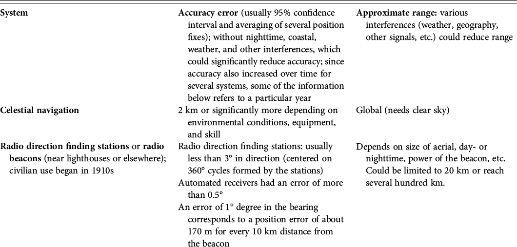
Table 5.2A Long description
The table has three columns. It presents the following data.
Row 1 column 1 reads. System.
Row 1 column 2 reads. Accuracy error, usually 95 percent confidence interval and averaging of several position fixes; without nighttime, coastal, weather, and other interferences, which could significantly reduce accuracy; since accuracy also increased over time for several systems, some of the information below refers to a particular year.
Row 1 column 3 reads. Approximate range: various interferences, weather, geography, other signals, etcetera, could reduce range.
Row 2 column 1 reads. Celestial navigation.
Row 2 column 2 reads. 2 km or significantly more depending on environmental conditions, equipment, and skill.
Row 2 column 3 reads. Global, needs clear sky.
Row 3 column 1 reads. Radio direction finding stations or radio beacons, near lighthouses or elsewhere; civilian use began in 1910s.
Row 3 column 2 reads. Radio direction finding stations: usually less than 3 degrees in direction, centered on 360-degree cycles formed by the stations.
Automated receivers had an error of more than 0.5 degrees.
An error of 1 degree in the bearing corresponds to a position error of about 170 m for every 10 km distance from the beacon.
Row 3 column 3 reads. Depends on size of aerial, day- or nighttime, power of the beacon, etcetera. Could be limited to 20 km or reach several hundred km.
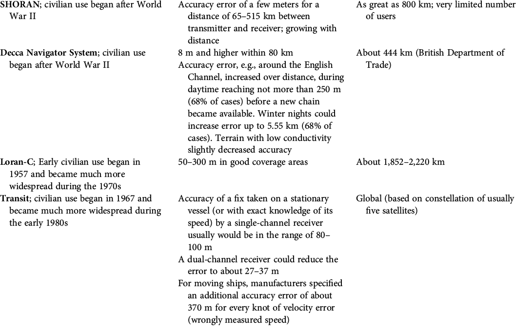
Table 5.2B Long description
The table continues to present the data for the three columns.
Row 4 column 1 reads. SHORAN; civilian use began after World War 2.
Row 4 column 2 reads. Accuracy error of a few meters for a distance of 65 km to 515 km between transmitter and receiver; growing with distance.
Row 4 column 3 reads. As great as 800 km; very limited number of users.
Row 5 column 1 reads. Decca Navigator System; civilian use began after World War 2.
Row 5 column 2 reads. 8 m and higher within 80 km.
Accuracy error, example, around the English Channel, increased over distance, during daytime reaching not more than 250 m, 68 percent of cases, before a new chain became available. Winter nights could increase error up to 5.55 km, 68 percent of cases. Terrain with low conductivity slightly decreased accuracy.
Row 5 column 3 reads. About 444 km, British Department of Trade.
Row 6 column 1 reads. Loran-C; Early civilian use began in 1957 and became much more widespread during the 1970s.
Row 6 column 2 reads. 50 m to 300 m in good coverage areas.
Row 6 column 3 reads. About 1,852 to 2,220 km.
Row 7 column 1 reads. Transit; civilian use began in 1967 and became much more widespread during the early 1980s.
Row 7 column 2 reads. Accuracy of a fix taken on a stationary vessel (or with exact knowledge of its speed) by a single-channel receiver usually would be in the range of 80 to 100 m.
A dual-channel receiver could reduce the error to about 27 to 37 m.
For moving ships, manufacturers specified an additional accuracy error of about 370 m for every knot of velocity error, wrongly measured speed.
Row 7 column 3 reads. Global, based on constellation of usually five satellites.
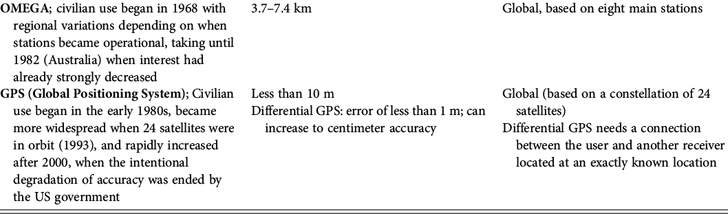
Table 5.2C Long description
The table continues to present the data for the three columns.
Row 8 column 1 reads. OMEGA; civilian use began in 1968 with regional variations depending on when stations became operational, taking until 1982, Australia, when interest had already strongly decreased.
Row 8 column 2 reads. 3.7 to 7.4 km.
Row 8 column 3 reads. Global based on eight main stations.
Row 8 column 1 reads. G P S, Global Positioning System; Civilian use began in the early 1980s, became more widespread when 24 satellites were in orbit, 1993, and rapidly increased after 2000, when the intentional degradation of accuracy was ended by the U S government.
Row 8 column 2 reads. Less than 10 m.
Differential GPS: error of less than 1 m; can increase to centimeter accuracy.
Row 8 column 3 reads. Global, based on a constellation of 24 satellites.
Differential GPS needs a connection between the user and another user located at an exactly known location.
The source is provided below the table.
These accuracy errors that grew with distance from radio beacons underscored the importance of physical world visualizations for position fixing, such as anchored, watertight, visible, and audible iron buoys featuring lights and whistles. Their global proliferation in the late nineteenth and early twentieth centuries provided some orientation even in nighttime and adverse weather conditions.Footnote 34 Notably, by 1970, there was still no legal act providing all oil rigs in the US Gulf of Mexico designated safety zones closed to other vessels for collision prevention. This was based on the rationale that vessels anyway would not be able to accurately fix the positions of these zones in relation to their own location without visually or acoustically spotting and subsequently avoiding the corresponding oil platforms, buoys, and other structures.Footnote 35 Essentially, position fixing in the physical world through audio-visible objects like buoys and other structures was very precise but also very limited in audiovisual range, complementing rather than replacing the less accurate contemporary methods of projecting a coordinate system onto the physical sea space.
The central issue, grounded in the terra-centric focus of radio direction finding, was that the rig could not signal its location in radionavigation space. The installation of a radio beacon at the offshore drilling site, although prohibitively expensive, would have allowed vessels to home in on its signal using a radio compass. It was only in the 1970s that this practice became more common on offshore oil platforms, especially those equipped with helicopter pads.Footnote 36 However, the concept of offshore radio beacons dates back much further, most notably to Edward R. Armstrong’s failed seadrome proposal and the US Navy’s implementation on aircraft carriers since the late 1930s, greatly improving aircraft navigation. For ship and aircraft navigators and pilots, the introduction of these beacons for homing reorganized oceanic space, resulting in an important geo-ontological shift related to oceanic placemaking. Homing effectively projected a direct line to the destination across a seemingly empty and endless marine space, establishing new, possibly movable places, like aircraft carriers or artificial islands, in previously peripheral areas of oceanic navigation. Human orientation in this setting no longer relied exclusively on the audiovisual senses and memory-based identification of natural or artificial markers like rocks, cornerstones, or buoys. Instead, it involved the artificial extension of the nervous system, converting invisible radio waves into audio or visual signals that could be traced back to their source. This navigation aid caused a transport space transition by strongly facilitating movement between two specific sites hosting beacons and mattered not only for the oceanic periodization of navigation; it also had further geo-ontological implications by changing oceanic time regimes in the latter half of the twentieth century through increased punctuality and regularity of crew shifts on offshore platforms. The ability to project a virtual line onto physical space, extending human audio or visual senses, reduced the impact of natural time constraints, such as fog and other adverse weather conditions that previously had severely limited human senses, thus representing a new human time regime. Consequently, radionavigation systems, by creating an electronic – and later digital – overlay on the physical world, reduced barriers to ocean-to-land globalization, establishing economic time regimes associated with the industrial era. In contrast, in 1938, the industrial demand for regularity and punctuality still conflicted with the rig’s location in a navigation dead zone.
World War II’s End and the First Stage in Ocean-to-Land Globalization
Exploring the onset of the oceanic Anthropocene by applying an oceanic-vertical perspective has yielded multiple insights in earlier chapters. A closer examination of the first stage of ocean-to-land globalization since the mid-twentieth century illustrates the role of the civilian mass use of radio technology in the global proliferation of artificial islands. This global proliferation is important, since, unlike land-to-land globalization in the nineteenth century, production sites were not predominantly in the global North, a phenomenon stemming partly from the reduction in communication and navigation costs. The first stage was closely tied to marine regions rich in oil and gas, creating the ghost acres discussed in Chapter 2, prevalent in both the Global North and South. The first stage of ocean-to-land globalization therefore reduced the previous Great Divergence between the Global North and South, which in marine regions all over the globe was succeeded by the oceanic Anthropocene. However, in the first half of the twentieth century, the Great Divergence was still evident in the locales where radio technologies originated. During World War II, even the Japanese military, despite overcoming much of the divergence, could not develop a high-quality radar system for military conditions.Footnote 37 After the war, the US, British, and German navigation and communication technologies were widely sold in Asia and other regions, contributing to the onset of the oceanic Anthropocene. The US military, especially during the Cold War, emerged as a primary innovator in radionavigation systems, but the equipment was manufactured by North American, Japanese, and European companies and made available to a mass market. This trajectory explains my focus on the civilian, ocean-centered, and non–nation state–centric proliferation of these technologies. The much more limited offshore oil drilling capabilities of communist-ruled countries, which I discussed in Chapter 2, also influence my focus, as this resulted in less civilian uptake.
This examination of ocean-to-land globalization centers less on the history of inventions or prototypes, which are a topic in the previous and the following three chapters. Rather, it is concerned with the commercialization, widespread use, and sometimes decline and disappearance of technologies over eight decades since the 1940s.Footnote 38 However, this mass use is inseparable from the process of states extending their political reach into previously remote marine regions, claiming them as territory, and becoming able to counter opposing views, much like earlier communication and navigation technologies, such as telegraphy and lighthouses, which various studies have analyzed as tools of empire-building and enforcing control over annexed territories.Footnote 39
The decrease in costs and the corresponding diminishment of trade barriers do not imply that the integration of marine regions into global markets has caused an erosion of territoriality or state-centered maritime boundary regimes. Many studies on land-to-land globalization, focusing on its late twentieth-century phase, suggested the weakening of state sovereignty due to decentralized information networks, such as the internet. They proposed a dichotomy between national territory and the multidirectional network flows associated with transnational actors like cities, with territorialization appearing to wane since the 1970s. These terra-centric perspectives, concentrating on the emerging neoliberal market regime, largely ignored the simultaneous territorialization and enclosure of the ocean.Footnote 40 The United Nations’ EEZ regime, internationally agreed on in 1982, only came into force in 1994. This coincided with land-to-land globalization’s second stage in the late twentieth century. Applications to the UN for extending EEZs and further enclosing oceanic space are still ongoing. Contrary to terra-centric views, I therefore see my conclusions more aligned with geographers Saskia Sassen and John A. Agnew, who argue that globalization’s reduction in trade barriers is compatible with the persistence of the principle of sovereignty. William Rankin’s historical evidence supports this evaluation.Footnote 41 Based on additional historical evidence, I largely concur with their view but stress the need to explicitly discuss the ocean to dispel any notion of mutual exclusivity between globalization and territorialization. On land, globalization’s erosion of borders and states increasing and enforcing sovereign claims over territory are not mutually exclusive, which must be understood within the spatial framework of all space on continents (with the exception of Antarctica) already having been claimed by states as territory. In the ocean, they are also not mutually exclusive, as state-led territorialization, or governmental ocean space grabbing, emerged alongside ocean-to-land globalization and the expansion of communication and navigation spaces. This convergence of economic and political spaces meant that after World War II, the new spatial reach-focused communication media and navigation aids led to a global geo-ontological change among government officials involved. The spatial transitions rendered many marine regions, previously considered remote and hard to control, more accessible and governable, a topic I will explore further in the following pages.
Following World War II, the exploration of offshore oil fields in the Gulf of Mexico by US companies was accompanied by unprecedented ocean space grabbing by the US government, with far-reaching global territorialization consequences. This surge was enabled by the communication and navigation space transitions of the 1940s and 1950s. During the war, oil played a crucial strategic role in industrial production, transportation, and mechanized warfare. The administrations of US Presidents Franklin D. Roosevelt (1882–1945) and Harry S. Truman (1884–1972) recognized the Allies’, particularly the United States’, oil reserves as key to their wartime success. Almost one-third of the United States’ known reserves were depleted during the war.Footnote 42 Aiming to increase domestic reserves, Truman, on September 28, 1945, made the “Truman Proclamation on the Continental Shelf,” proclaiming US jurisdictional control over the subsoil resources of the continental shelf contiguous to the US coastline, up to a depth of about 180 meters (100 fathoms). Previous claims from other countries had been more limited in nature. The Truman Proclamation was unprecedented in scale, covering a space more than one-fifth the size of the United States, approximately 2.2 million square kilometers, slightly larger than the Louisiana Purchase of 1803.Footnote 43 Initially, a draft news article by US Secretary of the Interior Harold Ickes (1874–1952) candidly stated that the United States, as the “No. 1 power of the world, had the result that no nation protested our action.” This forthright admission, indicative of imperialism and suggesting the proclamation’s character as executive fiat violating international law, was omitted from the final version.Footnote 44
The Truman administration’s main concern was the convergence of economic and political spaces in international waters. In the late 1930s, when offshore oil drilling extended into the Gulf of Mexico, the Roosevelt administration was already wary of foreign oil companies, supported by their governments, exploring offshore oil in the Gulf’s international waters. In 1944, when a US oil company started surveying these international waters, the Truman administration expected that the British government would encourage similar exploration in the international waters between the northwestern edge of the Bahama Islands – a British colony – and Florida. The prospect of promising oil fields stretching near Florida’s east coast, eventually proven wrong, led the administration to believe that, upon discovery, the British government would proclaim an occupation of these international waters or the seabed to have exclusive legal control over oil field development.Footnote 45 Therefore, the new economic space in international waters immediately converged with political space, created through proclamations, effectively reterritorializing the seabed and subsoil from a global commons into a form of state territory. The rapid convergence was characterized by a fractured political space where different states’ territorial claims, equally lacking legal basis and disagreeing on implementation questions, potentially clashed, as illustrated by the maritime boundaries conflicts in Asia and elsewhere discussed in earlier chapters.
One of the root causes of the political events explained was the exploration activities of Superior Oil. In the summer of 1944, with the diminished German submarine threat, the company commenced surveys in the open water of the Gulf, up to 40 kilometers offshore. These locations were far beyond the US territorial sea. Position fixing presented challenges for the fleet of seven ships, compounded by hardly predictable weather changes. Nonetheless, the deployment of buoys provided visual navigation aids and established fixed reference points in the physical world, aiding in correlating the newly created geological seabed maps with actual physical locations. The survey also showcased cost-saving techniques developed in the bayous, such as increased crew mobility. Despite higher equipment costs, offshore survey crews had the potential to operate much faster than land-based crews. Superior Oil’s survey project benefited from this mobility, though the full impact of postwar changes was yet to be felt. A year later, the end of World War II encouraged wider civilian use of radio communication and position-fixing devices. By the mid-1950s, equipped with such tools, offshore seismic survey crews could explore and move up to 100 kilometers per day. Even if such numbers were somewhat exaggerated, they still far surpassed the up to 80 kilometers monthly average of land-based crews.Footnote 46
Military expenditures in the United States and other countries during and after World War II played a central role in the technology revolution that enabled the transition to faster communication and transport spaces. After a period of exclusive military use, these technologies were made available for civilian use, allowing commercial companies to concentrate, for example, on the mass production of transmitters and receivers rather than developing new systems from scratch. In the postwar era, the offshore oil and gas industry and the shipping industry, followed by other sectors, utilized these new radio technologies, becoming available at lower costs.
The war saw a surge in radiotelephone use, from coordinating field operations to becoming vital for air force and navy communications. After the war, the US military sold much of its equipment. Oil companies purchased former navy vessels at substantial discounts, such as tank-landing ships (LSTs), converting them into submersible drilling barges for open waters. The designs represented an advancement from the second chapter’s submersible drilling barges that had gained in popularity during the 1930s in the bayous, and they also illustrate why Armstrong’s much more advanced and expensive designs, discussed in Chapter 4, remained unbuilt. The converted ships, equipped with radiotelephones that were also installed at coastal branch offices, greatly enhanced ship-to-shore and ship-to-ship communication.Footnote 47 In 1947, the installation of the first offshore oil rig out of sight from land made obvious the importance of radiotelephone communication, especially in the far more dangerous open Gulf conditions, compared to the bayous. For ocean-to-land globalization, the feasibility of large-scale fixation of capital in artificial islands beyond visual communication range, without affordable radiotelephone technology, was improbable.
Likewise, radionavigation equipment developed during the war was swiftly commercialized by British and US companies and governments. Systems for governmental hydrographic surveying, offshore oil surveying, and navigation, renamed as Fairchild SHORAN, Decca Sea-Fix, Raydist, and others, evolved into more affordable, portable, and precise versions than their wartime military predecessors. For both military and civilian users, they brought down equipment costs. The following example shows civilian adoption while illustrating that the Truman administration’s concerns about British offshore oil drilling interests, supported by subsidiaries of US companies, were not completely unfounded. In 1946, the government of the Bahamas granted Standard Oil (Bahamas) a lease for 5,000 square kilometers in waters northeast of the British colony (therefore not close to Florida). Unlike Superior Oil’s 1944 buoy-based exploration, Standard Oil (Bahamas) employed SHORAN (Short Range Navigation) for surveying and position fixing, whose accuracy far surpassed previous error-prone celestial navigation and radio direction finding. Other companies, such as Shell in the Gulf of Mexico, also acquired SHORAN equipment.Footnote 48
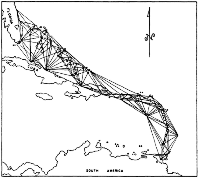
SHORAN was able to measure distance, not just direction. Developed in the United States during World War II for precision bombing and also used in the Korean War (1950–1953), SHORAN had an extended life as a high-precision surveying tool among civilian users (see Table 5.2). Its high accuracy resulted from permanently sending signals from vehicles, such as ships or airplanes, to ground stations responding to them (see Figure 5.1). The signal return time was then calculated into the exact geographical distances between them. Knowing the distances to two radio stations, and therefore the intersection of the position lines, reduced the accuracy error to a few meters. Yet, station capabilities were limited to supporting only a very low number of airplanes or vessels at the same time, curtailing its appeal for large-scale civilian applications.Footnote 49
SHORAN altered perceptions of marine regions as remote, ungovernable, and inaccessible. This illustration demonstrates how ships or airplanes could fix their positions very precisely by measuring the distance and direction to two or more stations. These accurate coordinates were than integrated with aerial photographs or seismic surveys of the seabed. SHORAN therefore emerged as an important radionavigation system in the post–World War II era, aiding in the large-scale governmental territorialization of oceanic space but being limited by the few users who could use it simultaneously.
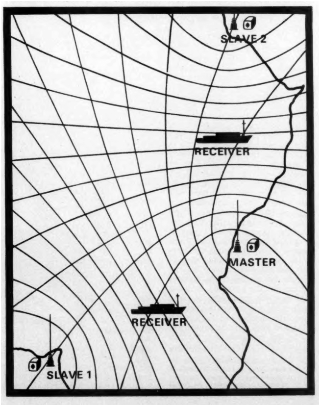
World War II also led to more universally applicable area navigation systems, like the Decca Navigator System and Loran-A (Long Range Navigation-A). Differing from SHORAN, Decca equipment did not send signals but solely received them from pairs of stations transmitting together at pre-coordinated times, so no absolute geographical distance to them could be measured. Instead, the time difference between the two signal arrivals was computed into the difference in geographical distance between the two stations to the receiver (see Figure 5.2). Knowing only this difference in geographical distance meant that the receiver could be at any point on the hyperbola between the two stations that corresponded to the distance. Three or four stations created multiple station pairs, therefore generating two or more hyperbolas whose intersection pinpointed the receiver’s position.Footnote 50 Decca’s accuracy was lower than that of SHORAN, its error being 8 meters and higher within 80 kilometers off the coast and growing with distance (see Table 5.2). However, as an offshore survey off Burma in 1966 made very plain, the unexpected inability to use Decca stations led to the surveying team complaining about an accuracy error of up to 600 m, a tremendous difference to Decca’s error.Footnote 51 Gaining an understanding of how the two different types of radionavigation systems worked is important, as it makes clear Decca’s substantial cost reductions compared to SHORAN. The benefit of area navigation systems only passively receiving signals was that any number of vessels, vehicles, and aircraft could use them at the same time. Despite the slightly higher error, Decca became more popular than SHORAN with its low number of parallel users, as confirmed by survey experts.Footnote 52
Decca was another radionavigation tool that significantly altered the perception of oceanic space as remote. In region where governments or companies established Decca Sea-Fix stations after World War II, projecting hyperbolic patterns onto physical ocean space strongly facilitated navigation and position fixing for oil drilling, shipping, fisheries, and other purposes. The hyperbolas corresponded to an electronic coordinate system or were convertible into longitude and latitude for use on nautical charts. One set of hyperbolas was determined by the difference in signal arrival times between (dubiously named) stations “Master” and “Slave 1,” while another set was based on the “Master” and “Slave 2” stations. Vessels and platforms fixed their position at the intersection of these hyperbolas. As a result, offshore surveying and navigation experienced enhanced precision, without limitation on the number of receivers within range.
The functionality of these two types of systems draws attention to the geo-ontological shift among users. Both functioned differently than maps, which operate through representation. The purpose of a map determines the mode of projection. This can include the use of grid systems that focus on geographical distance between sites, the use of longitude and latitude to facilitate offshore navigation, or the depiction of objects that then had to be encountered in the physical world. Modern Western maps typically arrange selected thematic features, such as topography, in a miniaturized, top-down view.Footnote 53 In contrast, markers in the physical world, like buoys or navigation perches (long poles fixed to the seabed), directly referred observers to a physical location. Electronic navigation systems took elements from both, artificially extending the human visual sense by creating a virtual coordinate space permanently overlaying the physical world. Present-day digital projections of user locations onto digital maps are common and strongly facilitate the inhabitation of physical space, such as GPS being digitally embedded in Google Maps and other mapping systems. SHORAN, Decca, and other radionavigation systems were not yet embedded. Yet the cybernetic coordinate overlay on the physical world, even more than the virtual lines of homing beacons, among users diminished the notion of marine regions as seemingly vast navigation peripheries without points of orientation, where instances of adverse weather made celestial navigation and other forms of position fixing using unmodified audiovisual senses impossible. Instead, radionavigation increased the legibility of marine regions, integrating them with terrestrial regions into a seamless navigation overlay whose extent shaped the new conceptualization of navigation centers and peripheries.
The expansion of Decca navigation illustrated a shift in marine regions whose coastlines featured station chains: they transformed into production sites, losing their former character as mere navigation peripheries. A study estimated that in the early 1970s, celestial navigation was still the most prevalent form of navigation across the globe. This reliance on celestial navigation was especially pronounced in the Global South, compared to the Global North. However, a review of Decca coverage in 1986, over a decade later, is a striking example of its growing importance and global usage.Footnote 54 In the Global North, Decca’s range covered all of Atlantic Europe, Japan’s waters, Newfoundland, and parts of Western Australia where offshore gas extraction occurred. Many of these chains, like Norway’s inaugurated in 1968, had been operational for decades, and it is important to note that those regions not covered used different systems. In the Global South, stations were also widely present, including in apartheid-era South Africa, the offshore oil-rich West African coasts under expanded coverage, northeast and northwest India’s waters, and the offshore oil-rich Persian Gulf, also experiencing coverage expansion. Decca’s link with offshore oil and gas drilling in the Global South is obvious, but I want to underline that in the Global North, industries such as fisheries and the burgeoning mariculture sector were also key users of Decca, meaning industries that were not exclusive to high-income, industrialized countries. Innovation in a Global North country did not preclude its widespread adoption in the Global South. The point here is to highlight the relationship between reduced transport costs, the emergence of offshore production sites, and the first stage of ocean-to-land globalization, happening in both the Global North and South, by decades predating land-to-land globalization’s internet-induced changes in parts of the terrestrial Global South. I do not claim that this process radically changed the economic inequality between the Global North and South. However, the intersection of Decca navigation with offshore production sites both in the Global North and South challenges the traditional narrative of land-to-land globalization that proposes the emergence of terrestrial production centers in the Global North and their inhibition in parts of the Global South until the late twentieth century. Furthermore, the spread of Decca navigation is a reminder of the offshore agglomeration process integral to ocean-to-land globalization. For example, the needs of Norway’s fisheries industry encouraged the installation of Decca station chains in 1968.Footnote 55 The transition in transport space and the ensuing decrease in navigation and position fixing costs subsequently accelerated the growth of Norway’s offshore oil industry, which discovered its first well in December 1969, and the salmon farming industry, particularly since the 1970s.
The postwar radionavigation systems facilitated vertical access to resources above or beneath the seabed but did not enhance the ability to detect underwater navigation hazards. Neither these systems nor later radionavigation iterations allowed volumetric position fixing below the sea surface. The surface effectively became the physical bottom, as saltwater rapidly absorbs higher-frequency radio waves, permitting only very low frequencies to penetrate more than ten meters below. This very limited data rate drastically reduced communication to mere coded signal reception.Footnote 56 The large volumetric space above the surface, accessible to communication and radionavigation systems, shows that transmitting information between the ocean’s surface and satellites very far above is easier than communicating with a point five meters underwater. Therefore, for navigation, vessels could not simply traverse straight lines between two points on the radionavigation overlay atop the physical sea surface, due to submerged hazards like sandbanks, reefs, shipwrecks, sunken oil rigs, and capped oil wells.Footnote 57 The use of local knowledge and acoustic-based navigation systems like sonar, further refined during World War II, helped in preventing collisions and damage. The submerged space remains, with few exceptions, a communication dead zone to this day, having discouraged any extension of the human habitat to it. The relatively recent “internet of underwater things,” employing acoustic data transmission, still lags far behind radio waves in terms of reliability and is vulnerable to hacking, jamming, and damage.Footnote 58 The sea surface, constituting a barrier to radiocommunication and radionavigation, is therefore a primary reason for the selection of topics in this book. For example, deep-sea seabed mining, made unrealistic by communication barriers and the issue of solid substances not easily moving vertically – which also prevented an Age of Coal in the ocean – was discussed for more than sixty years. Not materialized on a noteworthy scale, it is not covered here, although shallow-water mining operations are briefly addressed in Chapter 8.Footnote 59 Similarly, experiments with underwater habitats for divers in the 1960s and early 1970s, which inspired science fiction stories but would have strongly increased fatality rates, are not discussed. In the mid-1970s, the North Sea alone saw an average of twelve annual fatalities among offshore oil industry divers due to accidents, amplified by decompression problems – human bodies demanded hours of slow adjustment to pressure differences when moving between the sea surface and much deeper waters – that therefore prevented prompt medical aid. The humane and economical response was a shift to developing underwater robots rather than further pursuing underwater habitat experiments.Footnote 60 Consequently, deep-sea seabed mining, underwater habitats, and similar ideas have unsuccessfully struggled against the challenging material conditions of deep waters, highlighting the distinctly different trajectories of technological adaptation for spaces above and far below the sea surface.
Communication Cost Cutting in the Space Age
The Sputnik satellite launch in 1957 marked the dawn of the “space age.” This new age altered millennia-old conceptualizations of the world by technologically linking sea surfaces with Earth-centered orbits, a topic explored in Chapter 3. Previously, terra-centric ontologies defined the sea surface as a communication periphery and Earth-centered orbits as a communication dead zone, isolated both from each other and largely from land. Over the following six decades, this human-created linkage began synchronizing terrestrial and oceanic communication temporalities. The launch of the first Marisat satellite on February 19, 1976 marked a significant transition in offshore communication space. The launch of two more satellites during the subsequent eight months initiated the first near-global marine communication network serving military vessels, the shipping industry, and the offshore oil sector, among others. Owned by Comsat, a private corporation established by US federal legislation, the three satellites were strategically positioned over the Atlantic, Pacific, and Indian Oceans. This network connected vessels and the built environment across most of Earth’s sea surface to each other, as well as to terrestrial senders and receivers (see Figure 5.3). Despite its download speed of up to 2.4 kbps (kilobits per second; see Table 5.1), very much limiting the amounts of data exchanges, Marisat represented a technological breakthrough, providing offshore production sites access to satellite phone, teletype (for sending and receiving machine-typed messages), fax, data transfers, and television (slow-scan TV) capabilities. The slow speed would have precluded even basic web browsing had it already existed, so ships and helicopters continued to play vital communication roles in physical data transport, using media such as magnetic tapes and later hard drives to store extensive data from surveys, oil or gas wells, and bookkeeping records. Marisat’s service fees were not competitive compared with terrestrial rates in industrialized countries. Marisat phone call rates (US$10/min) were roughly triple that of an intercontinental call via a US carrier (US$3.6/min).Footnote 61 Nonetheless, many artificial islands, previously without such service access, benefited from this much faster communication space despite the high costs, offering novel functionalities. Even though launched more than a decade after the first land-centered communication satellites, Marisat’s importance lay in establishing the first communication space transition in those oceanic communication peripheries previously unreachable by radiotelephones or the booming short-range microwave transmission systems of the early 1970s, meaning marine regions that had witnessed no change since the rise of expensive radiotelegraphy.
The drawing, made after the first Marisat satellite was launched in February 1976, shows Marisat 1 (right) and Marisat 2 (left; launched in June 1976) above the Atlantic and Pacific oceans. Placed in geostationary orbit, the satellites rotated with the Earth and stayed above the respective oceans, which created a major communication space transition in the two roughly indicated areas. The Indian Ocean is hidden at the left and right sides, but a third satellite covering it was launched in October 1976. The illustrator also tried hard to show the impact on Atlantic and Pacific crossings by drawing only ships, overlooking the offshore sites of production that represented ocean-to-land globalization.
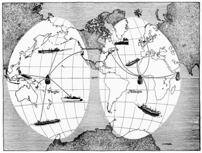
My argument regarding the steep decline in offshore communication costs is substantiated by data spanning almost five decades following the launch of Marisat 1 (see also Table 5.3). Following Marisat, multiple satellite communication companies began offering services to marine regions, especially crucial for those unreachable by other means. The limitations of Marisat led to the formation of an intergovernmental consortium of countries with strong maritime interests, encouraged by the International Maritime Organisation (IMO), to establish the Inmarsat satellite constellation, which commenced service in 1982, and to take over the Marisat satellites.Footnote 62 In 1996, its digital connection, introduced three years prior, offered download rates of around 56–64 kbps, substantially surpassing Marisat’s capabilities. In contrast, Intelsat, another intergovernmental consortium (now a private company), provided download speeds of up to 512 kbps in the same year, enabling additional functionalities including web browsing, larger file reception, and low-resolution video conferencing. A notable shift in download speeds came with the 2014 establishment of O3b Networks’ satellite constellation (O3b standing for the “other 3 billion” people of the Global South). In that year, it offered broadband download rates up to 20 Mbps. By 2023, cruise ships, for example, were able to provide 2 to 4 Mbps of download speed per device, sufficient for non-HD video streaming, albeit at substantial daily rates.Footnote 63 The most recent contrast to Marisat in this context is private space company SpaceX’s Starlink Maritime, launched in late 2022. Offering download speeds in the summer of 2025 of up to 220 Mbps for a monthly fee between US$2,150 (for 2 TB) and US$250 (for 50 GB), this service enabled multiple users to simultaneously engage in data-intensive activities like HD streaming, online gaming, or telecommuting at half or less the previous costs.Footnote 64 Considering the official inflation of the US dollar since 1976 (470% in 2025), the monthly US$2,150 rate for Starlink Maritime, allowing extensive use of internet telephony for numerous users throughout the month, equates to what was once the cost for just 38 minutes of Marisat phone calls (about US$57/min). The cost difference is staggering, spanning several orders of magnitude. While satellite receiver equipment for Starlink Maritime was priced at US$1,999 in the summer of 2025, Marisat receivers in 1976 were a hefty US$52,700, which would be approximately US$300,390 when adjusted for inflation until 2025, further emphasizing the dramatic decline in costs (that likely has further decreased in 2026, the year this book is published).Footnote 65
The drastic cost reductions have enabled the mass use of high-speed internet on artificial islands, accelerating Earth’s amphibious transformation. SpaceX’s switch in 2022 from its former satellite internet provider to Starlink Maritime illustrates this impact vividly, though the story also served marketing purposes. The switch cut communication expenses for offshore rocket launches by approximately 70 percent (from US$165,000 to US$50,000) and enabled HD video broadcasting of these events.Footnote 66 These figures seem realistic, especially when compared with current internet prices, for example, on cruise ships. However, it is important to recognize the global disparity in internet access costs and varying perceptions of affordability. In the Global North’s urban centers, where fiber-optic cable internet access is common, costs have become comparatively negligible. By contrast, regions in the Global South that rely on satellite internet continue to face higher costs, particularly in the absence of government subsidies. Thus, any discussion of affordability is inherently location specific. My argument on communication cost declines in ocean-to-land globalization emphasizes that the drastic relative reduction by multiple orders of magnitude since 1976 has had a much more profound impact on ocean industrialization and the emergence of internet-dependent offshore production sites than the currently remaining costs and their difference to land-based locations. These remaining absolute costs vary based on factors like subsidies, end-user prices (not prices for crew members), use of multiple devices, and speed. For example, Starlink Maritime’s lowest monthly rate of US$250 for 50 GB would be considered sufficiently low to allow widespread adoption in high-income and upper-middle-income countries. These costs exceed those in urban centers of the Global North but not by several orders of magnitude.
During the 2010s, oceanic and terrestrial communication temporalities began to synchronize. Studies usually link the second stage of land-to-land globalization to the latter half of the twentieth century, especially with the advent of the commercial internet in the 1990s. The internet revolution was regarded as the main reason for the drastic decline in communication costs. So, why exactly did this synchronization only occur in the 2010s? Three factors contributed to it. The first one is the strong increase in download speeds offshore between 1976 and 2022. While the download speeds listed in Table 5.3 (1976, 1996, 2014, 2022) can fluctuate, they demonstrate an average doubling about every three years.Footnote 67 I do not see this growth as a “law” similar to other IT “laws.” Future cost drops and download speed increases are foreseeable if the doubling period does not drastically slow down during the coming decades.
The second factor, with the most social implications, was that the 2010s marked the decade when broadband satellite internet became widely accessible offshore, not just to industrial customers but also to crew members and cruise ship passengers, a trend that expanded in the 2020s. Regular connectivity surveys conducted among crew members are another way, besides cost comparisons, to gain insights into the emergence of this mass market and the geo-ontological shift turning sea surfaces into communication space centers. The Crew Connectivity Report of 2018 revealed that 75 percent of crew members surveyed during the second half of 2017 had internet access offshore. For the first time, internet access was the most common form of connectivity, surpassing satellite phone connectivity, although its use could involve fees or exclude certain functions such as streaming, videocalls, or downloads. Access was particularly high, exceeding 90 percent, among crews of offshore platforms and passenger ships (including cruise ships), where the demand for satellite internet connectivity is strongest. On average, crew members carried three electronic devices, most commonly smartphones, followed by laptops. Some survey participants even stated that they used smartwatches and fitness trackers offshore, which can be seen as a use of both internet and, for tracking purposes, GPS access. The gender of respondents was not reported, so no gender-specific conclusions can be drawn. Notably, 92 percent of crew members stated that the availability of offshore connectivity strongly or very strongly influenced their choice of employer. Concerning my argument regarding communication cost declines and ocean-to-land globalization, the most important finding was that between 2015 and 2017, the crew connectivity market, involving about 1.6 million individuals, had declined by about US$900 million, reaching an estimated US$2.4 billion (about US$1.3 billion at sea and about US$1.1 billion ashore). Offshore, a decrease by US$500 million translated to a cost change from US$152 to US$101 per person per month. Factors such as the deployment of O3b Network’s satellite constellation, launched in 2014 (see Table 5.1), and the provision of subsidized or, in 45 percent of cases, free internet by shipowners contributed to this transition from satellite phones to internet usage. Ashore, the market decreased by US$340 million, presumably due to onshore cost reductions and free or discounted onboard services. In the 2020s, Starlink Maritime access further lowered these costs. The survey’s results indicate a decrease in the once very strong feelings of social isolation among crew members, with a shift in social behavior. On US oil platforms, crew connectivity had improved since the 1970s, when sporadic family calls became an option, but without noteworthy changes in social behavior. However, the survey showed that in the 2010s, social behavior among crews began to change with the ability to cybernetically connect, mediated by a smartphone or laptop, with geographically separated family and friends, causing them to shift more social activities from shared spaces to their cabins.Footnote 68
The changes in communication costs and technologies have not only impacted social interactions but also led to regulatory changes. In June 2022, the Maritime Labour Convention was amended, prompted by the social isolation during the COVID-19 pandemic. According to the provisions coming into effect at the end of 2024, shipowners “should, so far as is reasonably practicable, provide [crews] on board their ships with internet access, with charges, if any, being reasonable in amount.”Footnote 69 Shipowners being able to circumvent the obligation here is not the point. Rather, the amendment highlights that universal internet provision offshore is technically and economically feasible.
The synchronization of terrestrial and offshore communication temporalities in the 2010s is a foundational aspect of my analysis, exemplified by download speed increases and growing crew connectivity. The third factor in this synchronization is the synergy created by combining high-speed internet access and GPS-based, highly accurate position fixing, a characteristic central for terrestrial communication and navigation temporalities. These synergies define the second stage of ocean-to-land globalization and the growth of the related industries, causing the acceleration of Earth’s amphibious transformation. They would not have emerged in the absence of either high-speed satellite internet or GPS, so I return to them after examining the trajectory of transport cost declines leading to GPS.
From Transit to GPS, from the First to the Second Stage
The launch of navigation satellite systems beginning in the 1960s marked a global transport space transition, characterized by cost reductions and, in the case of US systems, also strong military control until 2000. These systems exemplify the divergent civilian and US military views on leveraging the connections between sea surfaces and Earth-centered orbits to turn the former into new navigation centers. In 1964, the Transit satellite constellation became operational, supporting the US Navy’s ballistic missile submarines. These submarines, equipped with Polaris nuclear missiles, required precise position fixing for effective launch and targeting to cause the end of the world as we know it. Johns Hopkins University’s Applied Physics Lab played a central role in developing this system, spurred by the analysis of Sputnik’s flight and possibilities to track the satellite. In 1967, Transit was made available to civilian users without charge, benefiting industries like shipping and offshore oil, coinciding with the first satellite launch of the Soviet equivalent, Tsiklon (later upgraded and renamed to Parus for military and Tsikada for civilian use). Transit, unlike other radionavigation systems, was not affected by adverse weather conditions like fog, and its equipment typically functioned well for years. Standard receivers could fix the position of a stationary vessel with an accuracy error of less than 100 meters, even far offshore. More expensive, high-end versions further reduced this error to about twenty-seven to thirty-seven meters through repeated fixes. The Glomar Challenger, a deep-sea research and scientific drilling vessel launched in 1968 by the Scripps Institution of Oceanography and the US National Science Foundation, demonstrated in 1970 the viability of deep-water drilling. Using a combination of navigation aids, including Transit equipment and an acoustic homing beacon dropped to the seabed, the ship was able to remain precisely positioned over wells and even accomplished hole reentries in waters three kilometers deep.Footnote 70 This showcase illustrated the most expensive possibilities in navigation, while a growing customer market, advancements in receiver technology, and competition between Transit equipment manufacturers from the United States, Canada, Japan, and the United Kingdom resulted in different functionalities and prices.
Like the drop in offshore communication costs, the plummeting prices of Transit equipment serve to underscore my argument about strong quantitative decreases. From 1965 to 1988, the price for a standard receiver (single-channel receiver) dropped from about US$100,000 to around US$1,000 (see Table 5.4). The miniaturization of computers and advancements in microprocessors that led to Moore’s Law in 1965Footnote 71 contributed to the dramatic price reduction by two orders of magnitude and the smaller size of receivers (see Figures 5.4 and 5.5). High-end Transit equipment (two-channel receivers) also incorporated other navigation systems, such as Loran-C (an improvement on Loran-A), Decca, Omega (utilizing up to eight radio stations transmitting very-low-frequency radio signals), or sonar. These versions, used by the offshore oil industry for position fixing, equally decreased in price, though comparisons are challenging due to system changes. In 1978, they cost US$500,000 or more, but by 1990 a survey-quality two-channel receiver had declined to about US$10,000. Another cost factor was the operating costs of running Transit, including ground stations and satellite replacements, covered by the US military. Around 1976, the annual cost was estimated to be approximately US$5.3 million, with each new satellite’s construction and launch priced at about US$3.5 million. However, here again, costs decreased over time due to technological improvements. The first generation of satellites, launched in the mid-1960s, lasted only one year due to their short-lived solar cells, but by the early 1970s their lifespan had increased to about four years.Footnote 72 Today’s energy transition toward solar photovoltaics therefore received early research attention and investment as a foundational tool for enabling satellite-based offshore communication and navigation. In contrast, receiver equipment used on vessels and the offshore built environment were characterized by the carbon lock-in effect discussed in Chapter 2, emerging from the synergy of electrically powering equipment with the readily available marine fuel oil or natural gas that powered motion or was a by-product of the extraction process.
Overview of Magnavox’s Transit receiver equipment complexity, 1968–1976. This period reflects important technological advancements, such as miniaturization, leading to a substantial reduction in both size and cost. Magnavox became a subsidiary of Philips in 1974.
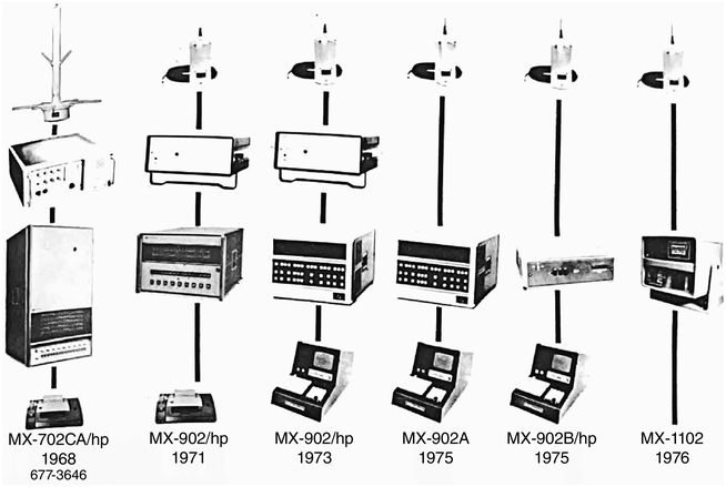
The Magnavox MX 4102 – a low-cost, single-channel Transit receiver from 1982 or later. The device played a central role in facilitating position fixing and navigation for its numerous users. While providing valuable location coordinates, its functionality was somewhat restricted, as it did not update these coordinates instantaneously or regularly. Unsurprisingly, it lacked integration with digital maps, a feature essential for modern applications such as ride-hailing services, which many of today’s smartphones offer.
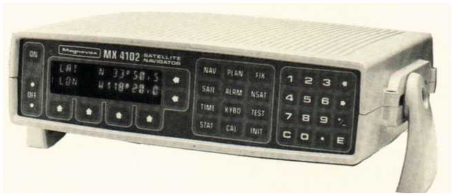
Transit user numbers grew rapidly, supporting and benefiting from the price decreases. From about 860 users at the beginning of 1974, the number surged exponentially to 48,900 in late 1983 and likely over 62,000 by the end of 1984 (see Table 5.4). Only Decca had a higher number of users during the 1970s, with about 23,000 receivers active and new ones priced at US$8,000 in 1978, although their use was limited to waters covered by Decca station chains.Footnote 73
Transit’s use in maritime operations significantly reduced transport costs, emphasizing that the equipment cost declines had real-world impacts. Several examples demonstrate how Transit equipment reorganized transport space, making it more efficient through the application of weather information, navigation assistance, and position fixing. For example, containerization, beginning in the late 1950s, allowed merchant vessels to spend considerably less time in ports. Increased time at sea therefore translated into efficiency improvements in transport space having an even greater economic impact than before. A 1981 study estimated that integrating weather satellite information in ship routing could reduce travel time by up to 10 percent and prevent injuries to crews. Avoiding adverse weather like typhoons on a Pacific voyage, meaning 9,000 kilometers or more, resulted in savings of US$15,000–40,000. Moreover, as an employee of a navigation equipment producer reminded his audience, between 1973 and 1981, two “Oil Crises” and their aftermath increased the price of marine fuel oil (or Bunker C) from US$4 per barrel to more than US$30, making fuel costs a major factor for shipping. He calculated that for an average tanker, savings of more than US$6,000 would be achieved for every 185 kilometers by which a journey was shortened. Shifting attention from fuel savings and travel speed to position fixing, Transit enabled open ocean fishing vessels, such as those operating in Oceania, to precisely record profitable fishing grounds.Footnote 74 Transit’s capabilities therefore increased economic efficiency but contributed to overfishing. All these efficiency improvements in transport space also facilitated artificial island use.
Another example of cost-cutting was Transit’s fully automated position fixing, although it was not the first of its kind. Alongside other forms of automation like unmanned engine rooms and autopilots for ship-routing, it allowed merchant fleets to reduce the number of crew members. For example, during the 1980s, the Japanese merchant fleet experimented with reducing the number from an average of twenty-four to fifteen or even fewer by training them in dual roles, one of which could be a navigator. Hiring crews from low labor-cost countries was often another strategy to reduce costs, but navigation automation played a role in decreasing labor-related transport expenses.Footnote 75
US Navy control over the Transit satellites until the system’s retirement influenced all its civilian uses. Despite its accuracy, the limited number of active Transit satellites, usually five to six, prevented continuous position fixing, a norm in today’s GPS technology, which uses twenty-four satellites. In Transit’s case, the time intervals between satellites coming into range and enabling a fix usually varied from 35 to 100 minutes, depending on latitude. The worst delays occurred when the gap between the orbits of two satellites widened in 1977, leading to intervals between fixes reaching eight to ten hours, which caused considerable cost increases for survey operations that required a large number of fixes to minimize accuracy error.Footnote 76 Another challenge was how Transit used the change in radio wave frequency that the receiver registered while a satellite moved along its orbit, first coming closer and then moving farther away (Doppler effect). The frequency change allowed for determining the distance between satellite and receiver but potentially increased the accuracy error if the receiver was also moving (see Table 5.2). Unlike Decca or GPS, the fix was not near-instantaneous, as the computer took up to one minute to calculate, posing challenges if the vessel’s speed was not accurately entered.Footnote 77 These manifold challenges here serve to underline that civilian users’ conceptualizations of marine regions and technological needs for position fixing were disconnected from those of US Navy users. For the US Navy, marine regions, and especially the water column, were perceived as strategic hiding spots for submarines and useful for launching nuclear weapons after ample time was spent on position fixing. In contrast, for civilian users, the ocean was increasingly territorialized and covered with boundaries, bringing us back to the connection between ocean-to-land globalization and the governmental ocean space grab.
The expansion of ocean-to-land globalization during the 1960s and 1970s depended on accurate position fixes to convert boundaries on representational maps into tangible boundaries in the physical ocean. This accuracy was crucial for governments for awarding concessions, especially in areas with multiple coastal states, like the North Sea. Maritime boundaries in the North Sea were defined in 1965, a year after the 1958 UN Convention on the Continental Shelf came into force. The convention, resulting from the governmental ocean space grab since 1945, enabled states to exercise jurisdictional control over continental shelf resources up to a depth of 200 meters or within technologically reachable limits.Footnote 78 As William Rankin observed, radionavigation aids were mentioned by several delegates as a reason for the territorialization process occurring, as precise position fixing became the condition for delineating exact maritime boundaries between states and demarcating oil and gas field extensions.Footnote 79 Yet, compared to the entire oceanic space enclosed, such boundary disputes were very limited in scope and often revolved around island ownership or baseline drawing issues, challenges that radionavigation could not resolve.Footnote 80 In my opinion, the delegates were more preoccupied (though this was unspoken at the meetings) with the fact that most oil fields lay away from contentious marine boundaries, but without radionavigation aids, discovering, exploring, and exploiting them would be prohibitively expensive or impossible. Recall the example of the fog-enshrouded rig in the Gulf of Mexico. Furthermore, I believe that the contemporary offshore communication space transition geo-ontologically influenced the delegates. In 1958, the radiotelephone communication space stretched from coastlines to marine regions but not across the entire ocean, meaning that the peripheral part more distant from land still relied on much less effective radiotelegraphy. The legislative claims over the continental shelf, but only over it, reflected this offshore communication hierarchy. The continental shelf became a form of terra nullius, open for territorialization with the same expansionist, albeit much less colonialist, undertone that the term held in earlier times. Meanwhile, the space beyond remained a global commons of still limited political and economic relevance, showing governments’ interest only in the accessible part. Unsurprisingly, ocean scholar Elisabeth Mann Borgese’s 1968 proposal, which was not interested in this spatial communication hierarchy, aimed to manage the area beyond contemporary territorial claims as a space governed by an international organization but received no support.Footnote 81
Maritime boundary conflicts, both between states and within a single state’s waters, illustrate the geo-ontological shift in sea surface inhabitation caused by accurate position fixing and the visualization of virtual boundaries in physical space. Within a state’s waters, spatially defined activities like offshore oil drilling and, later, industries like mariculture intensified boundary creation and competition for marine space, sometimes tracing back to fishing or pearling and the formal or informal allocation of fishing or pearling zones.Footnote 82 In contrast, before the governmental ocean space grab beginning in 1945, the exact locations of maritime boundaries in the physical world were of little concern to governments, usually unmarked in open waters. However, from the mid-twentieth century, navigation aids were essential for legitimizing jurisdictional control over offshore oil fields by projecting virtual coordinates onto the physical world, aligning its physical space with the reality-simplifying lines on maps derived from intergovernmental treaties or unilateral proclamations. Maritime boundary conflicts could stem from disagreements over jurisdictional control of islands and rocks, such as in the East and South China Seas, or concern the location of transboundary oil deposits in physical space. For example, the North Sea’s Frigg gas field, discovered in 1971 and starting to produce in 1978, presented an international controversy between Norway and the United Kingdom. After the maritime boundary between the two countries was calculated and mapped, accurate position fixing of drilling operations was critical to ascertain the field’s extent, the boundary bisecting it in physical space, and each country’s share. Estimates concluded that an error of just one meter corresponded to a loss of about US$2 million in natural gas. Consequently, in 1982, a Chevron employee noted that many governments legally mandated offshore oil companies to minimize the accuracy error to within five to ten meters, achievable only by averaging a large number of Transit satellite passes in combination with using other systems – a time-consuming process (see Table 5.2).Footnote 83
Transit, becoming increasingly affordable, encouraged the extension of the built environment onto sea surfaces, but GPS provided solutions to its multiple deficits. GPS, a US Department of Defense initiative, was developed in response to coordination challenges during the Vietnam War (1960–1975). According to Bradford W. Parkinson (b. 1935), a former Stanford University professor of aeronautics and astronautics who as a US Air Force colonel had overseen the development of GPS between 1973 and 1978, the coordination problem eventually revealed that more than a hundred different navigation systems were in use. Reducing the number of parallel systems with different accuracy errors was the main reason for the US Department of Defense permitting the development of GPS.Footnote 84
GPS aimed to standardize position fixing by providing coordinates in three dimensions, unlike Transit, which did not measure altitude, as the US Navy’s concern was submarines (and oceanic material conditions prevented depth calculation). Transit’s two-dimensional fixes, like those of many other navigation systems, perpetuated the user perception of the ocean as a flat navigation space, despite the volumetry of artificial islands. The GPS constellation of twenty-four satellites, completed in 1993, ensured that at any given time, four satellites were within receiver range. Three satellites helped fix the position in each dimension and a fourth synchronized its atomic clock and the receiver’s clock to accurately calculate distance. The invention of atomic clocks in the 1950s, their refinement during the subsequent decades, and their use in orbit were essential contributions to GPS’s accuracy.Footnote 85 More precise timekeeping compared to Transit’s older satellites therefore reduced GPS’s accuracy error to below 15 meters.
The introduction of differential GPS in civilian use since 1984 (see Table 5.2), even before the satellite constellation was complete, exemplifies a dramatic increase in precision and substantial cost reductions. The difference between a reference station’s known coordinates and the slightly diverging coordinates a GPS receiver located at it produced was transmitted and applied to the fix done at the relevant location, resulting in centimeter-level accuracy. Advocates of the offshore use of differential GPS nevertheless had to wait until the full GPS satellite constellation was operational, when receiver manufacturers began to write the necessary software and, like in Transit’s case, created a mass market, characterized by rising user numbers and declining equipment costs. One author estimated that the very high accuracy, coupled with the near-instantaneous availability of a position fix, represented at least a fiftyfold improvement over Transit, which is certainly the case if ten to twenty-five Transit fixes and more than thirty minutes passing between them are considered.Footnote 86 Between the completion of the GPS satellite constellation in 1993 and the US government ending the intentional degradation of accuracy of civilian GPS in 2000 (the so-called selective availability that served to impede hostile acts against the United States), differential GPS already provided a method to circumvent these limitations.
Although free for users, the infrastructure of GPS and similar global navigation satellite systems like Russian Glonass, European Galileo, or Chinese Beidou required taxpayer funding. For example, the US government’s expenditure on GPS was about US$1.5 billion in 2012 and US$1.81 billion in 2022, amounting to a small per capita cost (for a cost and functionality comparison with other systems, see Table 5.3).Footnote 87 Although mainly funded for military purposes through the US Department of Defense, civilian uses increased over time beyond navigation, including global time-stamping and, for example, climate change measurement through ocean temperatures.Footnote 88 By 2025, the costs of simple GPS receivers had dropped drastically compared to the 1980s, reminiscent of those of Transit, with basic models available for less than US$10.Footnote 89 Smartphones, tablets, and smartwatches now commonly include GPS receivers, resulting in widespread use. From the 1990s, car navigation systems had already created a growing GPS receiver market, and more recently, aerial and ground drones (like lawn mowers) also began to use them. Position fixing on the ocean, on land, and in the air is neither inaccurate nor expensive anymore. Tablet apps for marine navigation on sailing boats are an example of this transformation, cybernetically extending human senses horizontally by providing a highly accurate integration of physical locations into digital maps at low costs.Footnote 90 GPS’s virtual coordinates overlay atop physical space also provided a cybernetic capability to locate, track, or change the positions of machines such as inspection drones operating vertically above the sea surface. Essentially, Earth’s amphibious transformation through the use of artificial islands, serving to enable vertical interactions with spatial layers above or below the surface, underwent an acceleration with this horizontal and vertical sense extension, contributing to the onset of the second stage in ocean-to-land globalization.
Communication and Navigation Synergies Offshore: From Ride Hailing to Autonomous Vehicles
Offshore production sites constitute consumption sites, although their scope has remained very limited to this day. Apart from consuming commodities like fuel and food, digital data consumption patterns have strongly intensified. The increase in internet download speed, facilitating data consumption, accompanied each new satellite constellation. This trend is coupled with the widespread use of highly accurate location data through navigation aids like low-cost GPS receivers in smartphones and smartwatches. Since the 2010s, the second stage of ocean-to-land globalization has been marked by the onset of an agglomeration process. Unlike the first stage, during which the location of industries was dependent on the contingent locations of oceanic resources such as oil or gas, the development of additional industries in this stage has been driven by the synergies of GPS and high-speed satellite internet. These synergies have enabled innovations in position tracking (or remote position fixing), crucial for the control of semi-autonomous robots (telerobotics) and the development of autonomous vessels and vehicles.
My first point on the synergies revisits the question of geo-ontological implications, specifically the transformation of a long-standing characteristic of sea surface habitation. Routine interactions play a critical role in fostering a sense of security among individuals. They create feelings of continuity, encompassing social relationships both within one’s immediate environment and beyond. Interruptions in these feelings of continuity, resulting from routine interactions ceasing when crew members became isolated from their friends and families, therefore caused a decreased sense of security among them.Footnote 91 The combination of GPS and high-speed internet enables routine checks on people’s locations. Such voluntary tracking is causing a shift from uncertainty about the whereabouts of family members or friends at sea toward a virtual coordinate overlay for precise visualization of their positions in marine regions. This development, similar to how ride-hailing apps introduced tracking of terrestrial vehicles without constant driver involvement, enabled position sharing on smart devices to track family members, merging navigation and internet connectivity. Increased feelings of safety therefore emerged not only from routine interactions like sending messages or writing postcards but also through location data sharing.
A second, related geo-ontological change caused by GPS and high-speed satellite internet pertains to the practical safety of sea surface habitation. An analysis of British shipwreck statistics since 1852 reveals that in 1863, during the ascent of the British Isles as the world’s most important maritime trade hub in the first stage of land-to-land globalization, 413,973 vessels entered and exited its ports, with individual vessels appearing multiple times in this number. In that year, decades before the introduction of radionavigation aids, 569 vessels were completely destroyed in collisions or wrecked against shores, 1,095 were partially damaged, and at least 620 people perished. Based on these numbers, each trip had a 0.137 percent chance (1 in 730) of ending in complete vessel loss, although factors such as vessel age and season influenced these probabilities. Between 1861 and 1870, 5,826 vessels were lost around the British Isles and 11,076 partially damaged, indicating that the figures for 1863 were slightly below average. In the same ten-year period, at least 8,105 sailors and passengers died, while 46,803 were rescued.Footnote 92 By contrast, in 2020, the United Kingdom lost eight fishing vessels and two motorboats in its waters, with fourteen fatalities, half on noncommercial recreational crafts. From 2011 to 2020, not a single large merchant vessel (≥100 gt) was destroyed, with twenty people (sixteen crew, four passengers) dying on them, sixty on fishing vessels, and a few more on small merchant and noncommercial recreational vessels.Footnote 93 Ship design improvements over approximately 160 years, navigation, and communication system changes have reduced the number of shipwrecks and decreased fatalities by about 98 percent. As studies regularly emphasized, advancements in communication and navigation technology have made pivotal contributions to preventing collisions and in leveraging telemedicine options or rescue missions.Footnote 94 It is important to note that the conditions on merchant and fishing vessels differ from those on even safer, tourist-focused cruise ships or potential artificial islands for habitation purposes. The work-related deaths in dangerous environments like on oil and gas drilling platforms, in contrast, although reduced by GPS and high-speed satellite internet, are not a useful benchmark for safety at sea. Thus, this example, focused on the British Isles, challenges and empirically refutes any terra-centric perceptions of sea surface habitation in this region in the twenty-first century bearing any resemblance in terms of danger or disasters to the nineteenth century and earlier.
My third point exemplifies the synergy effects, based on a brief analysis of new industries that have emerged when the costs of GPS, satellite internet, tracking, and vehicle autonomy decreased below previous barriers. For offshore rocket launches, accurate position fixing dates back to Transit, designed to plot the locations of ballistic missile–launching submarines. As I showed in Chapter 3, Sea Launch Co. was founded in 1995, two years after the GPS satellite constellation became fully operational. Several satellite communication constellations were already established when launches began, which supported the launch platform, the rocket, and the command ship. Notably, Sea Launch’s unsuccessful business endeavor was to facilitate the installation of faster satellite internet constellations. Since the 2010s, private space companies and national space agencies have expanded the offshore launch and landing industry, utilizing further cost drops. Precise rocket returns to autonomous landing platforms utilize GPS, satellite internet, tracking, and other technologies.Footnote 95 Similarly, autonomous ferries, boats, and barges represent this trend. For example, on-demand ride-hailing services, combining position fixing and internet access, create app-based digital GIS interfaces for locating and tracking vehicles and passengers. On aquatic surfaces, bringing human-operated boats and experimental autonomous ferries to customers hailing them relies on these communication and navigation systems.Footnote 96 Smart fish farms demonstrate the impact of reduced communication costs on previously manually operated facilities, allowing the use of the Internet of Things to automate processes such as monitoring fish health and growth, water conditions, and feeding schedules. Autonomous feed barges, used to feed multiple cages, also integrate communication and navigation technologies.Footnote 97 Maritime autonomous surface ships, currently under development for potentially crewless ocean crossings, equally depend on this technological combination for orientation, order implementation, and tracking.Footnote 98 Additionally, previously mentioned aerial drones, used for inspecting and maintaining artificial islands, among them wind turbines and fish farms, require network access to be operational and trackable. GPS is important for setting operation waypoints and enabling their return home in case of communication signal disruption due to adverse weather. Drones have also introduced new forms of sensing and monitoring technology in fisheries, such as locating schools of fish, or serve conservationist purposes.Footnote 99 Drifting, technologically advanced fish aggregation devices, introduced in the 1980s, lure fish to specific locations, visible to fishing vessels through the devices’ GPS transmitters. Approximately half of the current tuna catch is obtained in this manner. Both technologies have facilitated overfishing, with fish aggregation devices contributing to the unintended capture and death of sharks and rays preying on the attracted fish.Footnote 100 However, the use of these technologies depended on human decisions, and their negative impacts in certain cases do not preclude their application in sustainable fisheries. All these industries represent the second stage of ocean-to-land globalization. At the same time, below the sea surface, cable-based telerobotic operations of vehicles performing tasks such as inspection and maintenance since the 1970s, albeit with a more limited scope of functionalities and much lower level of autonomy, are another reminder of the spatial boundaries of radio waves.Footnote 101
From a governmental perspective, the satellite internet–GPS combination and its synergies have contributed to the numerical increase in vessels and artificial islands. Coordinating ocean industrialization through marine spatial planning involves assigning water plots to specific industrial purposes while preserving others like marine protected areas and regulating commercial shipping lanes.Footnote 102 Tracking, GPS, and offshore communication have been vital in creating a coordinates-based connection between the physical ocean world and official maps for space allocation and policing. This combination and its synergies have also reduced the costs of a specific form of policing and environmental governance. A vessel’s Automated Identification System (AIS), made mandatory in 2004, displays nearby vessels. Vessels transmit their GPS position, speed, and direction to AIS base stations, sharing these data with other vessels to prevent collisions. Yet, near real-time analysis of satellite images for vessel positions, using machine vision to identify them and determine their coordinates, followed by a comparison of these coordinates to AIS signals, allows for detecting “dark ships” – vessels not transmitting AIS signals. The absence potentially indicates illegal activities such as fishing or trafficking, which can be policed in this way.Footnote 103
Cybernetic Sea Surfaces
In ecosystems, biological communication systems operate and control interactions with the environment through sensory mediation. Similarly, communication and navigation technologies act as artificial continuations of biological evolution, adapting human nervous systems to sea surface conditions. These cybernetic sense modifications, such as extended communication distance, new artificial senses for orientation, and access to autonomous machines (or neural network replications in artificial bodies), therefore created a massive change in user capabilities to implement and control interactions with sea surfaces. Instead of transforming the physical world by creating terrestrial conditions through land reclamation, the virtual coordinates overlay and other forms of cybernetic neural network extensions realized a senses-based adaptation process replicating biological evolution. The first and second stages of ocean-to-land globalization therefore caused a spatial separation of production and consumption sites, characterized by cybernetic networks leading to more efficient operations in physical ocean space and a reduced need for human physical presence in this space. The process of incorporating marine regions into a global market also encouraged governmental territorialization processes in the form of a huge ocean space grab, an extension of political technologies to sea surfaces closely aligned with the cybernetic extension of human nervous systems and the physical extension of the human habitat. This process emphasized the connection between territorialization and the material conditions of different geophysical layers, leading to political enclosure when cybernetic communication and control technologically enabled political communication and control.
Post–World War II, the emergence of civilian mass markets for radiotelephones and radionavigation aids extended human neural networks beyond the capacities of eyes and ears, previously enhanced by devices like telescopes, flag semaphores, flares, lighthouse beacons, bullhorns and foghorns, and wireless telegraphs. Earlier examples of navigation challenges and oil company experiments with radiotelephones highlighted the changes beginning in the 1930s. Below the sea surface and beyond the range of most radio waves, acoustic sonar systems artificially replicated the echolocation (or biosonar) sense of cetaceans for spotting underwater objects – and, when unintentionally used near them, confused or shocked their biological systems. On the sea surface, artificial sense extensions enabled remote control of automated processes, which altered sea surface habitation by making artificial islands more ecologically autonomous and therefore less susceptible to disasters. For example, the 1960s and 1970s saw the development of simple autonomous systems for fire detection and automated emergency signal sending. Remote access to oil platforms kept them producing even after their crews were evacuated due to approaching hurricanes or other threats, until the artificial extension of human neural networks was used to initiate the automated shutdown sequence.Footnote 104 Artificial sense extensions and increases in data exchange rates therefore led to a series of improvements in telepresence on vessels and artificial islands. Only a few years after the Marisat satellite launches in 1976, a US company created an emergency telemedicine network for oil platform accidents in US waters, initially being limited to artificially connecting land-based hospital personnel’s audio senses to medics on platforms through a phone connection using new NASA medical service satellites.Footnote 105 In similar ways, remote sensing enabled the examination of objects or conditions beyond the spatial reach of human biological senses, including views from outer space through satellites. Similarly, these satellites and other radiocommunication or radionavigation technologies extended human neural networks by adding additional senses. For example, phenomena outside the electromagnetic spectrum or the object size perceivable by the human eye were artificially visualized, enlarged, or shrunk through satellite images showing weather conditions, sea surface temperature, oil spills, iceberg locations, or phytoplankton-rich fish feeding grounds based on chlorophyll a concentration.Footnote 106 Although telepresence capabilities were, for decades, more advanced in terrestrial areas with higher data rates, oceanic and terrestrial temporalities began to synchronize in the 2010s. The data-intensive video-telemedicine example at the beginning of this chapter showed the functionality upgrade when data transmission rates increased through new satellite internet constellations, extending the doctor’s ears (the stethoscope) and eyes (the ophthalmological scanner) to patients on platforms, demonstrating that more forms of service provision became spatially disconnected from physical locations. Likewise, during the 2010s, a smartphone camera used by a person offshore could serve as the artificial eyes of someone geographically distant, as could the camera of an aerial drone.
Maritime histories, whether focusing on civilian or military aspects, often assert that steam power “conquered” the oceans by enabling ships to operate year-round, surpassing and outmaneuvering sailing ships.Footnote 107 For motion, steamships and their successors did not depend on the winds and currents that for millennia had shaped the “age of sail.” Sailing ships had been forced to take routes according to the typical direction of the energy sources like winds and currents that moved them. Natural time regimes, like the Asian monsoons, had structured human travel regimes. Steam technology did enhance ship mobility and was an important factor in reducing travel costs by facilitating more direct routes and higher average speeds than sailing ships. However, this view of the ocean is, once again, rooted in a terra-centric conceptualization of sea surfaces as almost empty spaces traversed by ships moving between coastal ports or engaging in transitory practices like fisheries and whaling. As soon as non-transitory production sites are added to the focus, it becomes evident that it was not steam power but radiocommunication and radionavigation that defined the beginning of a new era. In this new era, novel cybernetic audiovisual systems extended human senses previously rendered defunct by weather conditions such as storms, heavy snowfall, and fog, although these systems could also be affected by such weather elements. The new technologies enhanced operations under adverse weather conditions or their avoidance through receiving advance warnings, strongly changing oceanic mobility patterns, more so than steam power. My central point here is not to diminish the importance of steamships but to emphasize that it was radio technology that brought about profound geo-ontological shifts. This intensity of geo-ontological changes further increased with high-speed satellite internet and GPS becoming available on sea surfaces and entering the consumer mass market, encouraging a user conceptualization of marine regions as governable, legible, socioeconomically developable, safe, accessible, and central – no longer isolated, peripheral, or remote within a planetary-wide, amphibious conceptualization of the human habitat. William Rankin argued that navigation systems represented the Western culture’s obsession with precision, but I would expand this claim to say that they, along with other radio technology offshoots, embodied all the adjectives from the previous sentence, signifying the civilizational goals of Western modernity and, unlike steamships, laid the foundation for private and public investors to commit to fixing capital in artificial islands.Footnote 108
Ocean-to-land globalization is a submodel of a broader model of an amphibious world, focusing on non-transitory offshore production sites emerging as the result of declines in communication and transport costs. In the 1990s, as the commercial internet began transforming perceptions of terrestrial globalization’s economic centers and peripheries, marine regions had only been wirelessly interconnected for less than a century. Multiple communication space transitions had lowered offshore communication costs and increased functionalities. These developments enabled the extension of the human habitat onto sea surfaces, shifting them from communication dead zones prior to the twentieth century to peripheries and, eventually, to central hubs in a planet-wide communication space. A remaining barrier to even more equal access to these communication spaces is the cost of equipment and subscription fees. However, the connectivity of marine built environments and vessels has reached a very high degree and continues to expand. During the latter half of the twentieth and the beginning of the twenty-first centuries, advancements in radionavigation as another branch of radio technology cut costs even more and made everyday use on sea surfaces possible, caused by the series of transport space efficiency improvements related to systems such as Decca, Transit, and GPS.
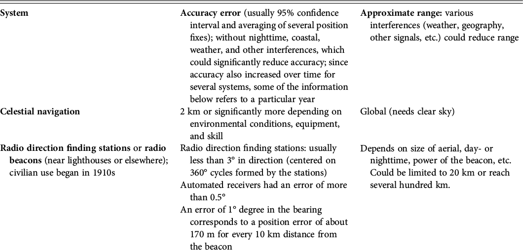
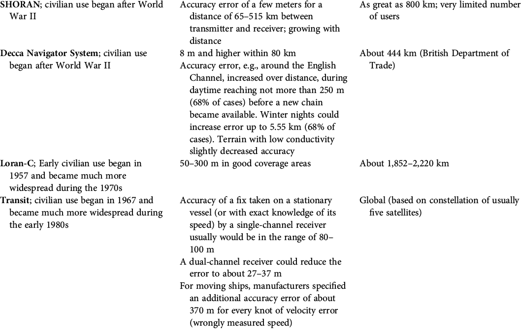
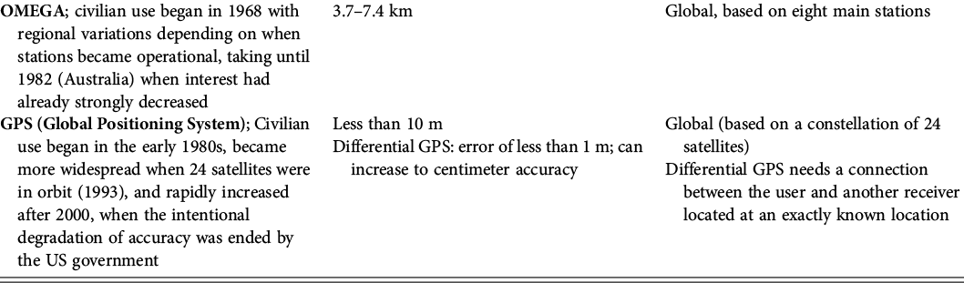
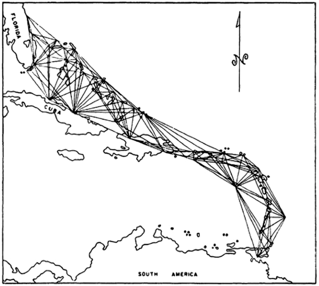
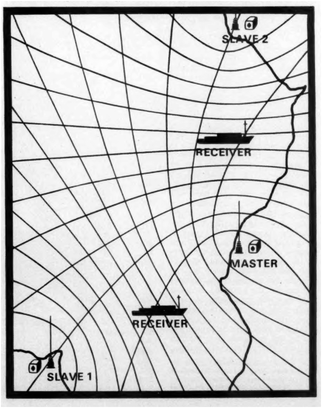
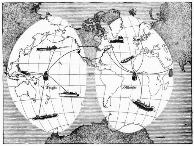
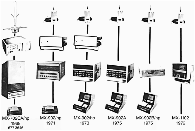


 Open access