Nature of the project
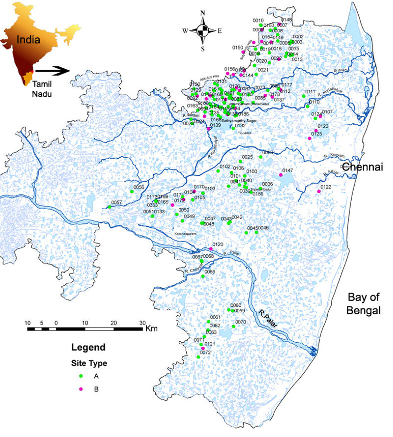
Northern Tamil Nadu along the south-east coast of India has evidence of long-term occupation from the Acheulean to the Late Palaeolithic and microlithic phases (Reference PappuPappu 2001). This provides an opportunity to investigate transitions through time and their implications in terms of hominin behaviour and dispersal across south Asia. In 1999, a project was initiated to investigate issues related to the nature and age of occupation of hominin populations in response to changing environments through excavations at the multicultural stratified open-air site of Attirampakkam (Reference Pappu, Gunnell, Taieb, Brugal, Anupama, Sukumar and AkhileshPappu et al. 2003, Reference Pappu, Gunnell, Taieb and Kumar2004; Reference Pappu, Kumar, Goren-Inbar and SharonPappu & Kumar 2006). Subsequently, an area of around 8000km2 (Figure 1) was investigated using satellite remote sensing, GIS, field surveys, excavations and palaeoenvironmental and geochronological studies. In addition to the goal of answering our research questions; a component of heritage management was included owing to the intensive destruction of sites. Differing resolutions of satellite images (IRS 1D LISS 3 of 23m, IRS 1D PAN + LISS 3 merged satellite data of 5.8m, IKONOS 1m) were used to generate thematic maps. These, along with GIS and spatial analysis techniques, aided in addressing research queries and were used for management purposes (Reference Pappu, Akhilesh, Ravindranath and RajPappu et al. 2009a, Reference Pappu, Akhilesh, Ravindranath and Raj2010).
The study region (12° 15′ 00″ to 13° 30′ 00″ N; 79° 30′ 00″ to 80° 22′ 00″ E), northern Tamil Nadu, showing distribution of prehistoric sites in relation to drainage. Site type: A) discovered by the team/previous scholars and revisited/restudied; B) site description based on existing literature.

Geology
The study area is a foothill zone linking the elevated topographic barrier formed by the Eastern Ghats in the hinterland to the Bay of Bengal coastal zone. The diverse environments and habitats across this narrow regional belt, which sits between quartzite hill ranges and the coast, and which is marked by riverine environments, would have accounted for the attractiveness of the region for hominin groups throughout the Pleistocene.
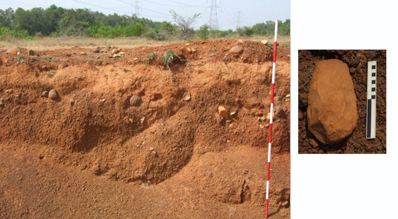
The region is characterised by the Cretaceous Satyavedu Formation of which the Allikulli and Satyavedu hill ranges in the north-west of the study region (200–380m asl; cobble-to-boulder size fanglomerates or palaeodeltas) constitute the main source of raw material for tool manufacture. The Cretaceous Sriperumbudur and Avadi formations occur in the low lying surrounding regions (Reference Muralidharan and KumarguruMuralidharan et al. 1993; Reference Kumaraguru, Rao and DimriKumaraguru & Trivikrama Rao 1994; Geological Survey of India 2006). These are capped by Cenozoic laterites and conglomerate beds. Sites of all phases occur on the surface of Cretaceous formations and on Cenozoic laterites. Sites also occur within ferruginous and ferricrete cobble to boulder beds, within a range of facies of Middle to Late Pleistocene ferricrete sediments, and in non-ferruginous/ferricrete fluvial gravels and argillaceous deposits (Figure 2). The site of Attirampakkam is in a unique context with Acheulean artefacts occurring in a laminated argillaceous deposit, underlying a thick sequence of sediments with stratified Late Acheulean and Middle Palaeolithic assemblages. A chronology of these deposits is being constructed using OSL, cosmogenic Be and palaeomagnetic measurements.
Acheulean artefacts within ferricrete gravels (the site is currently being destroyed by quarrying) and inset: close up of a biface.

The resource
A database of 197 sites and Quaternary sections was created consisting of 165 prehistoric sites in 138 complexes (the latter comprises several sections or smaller sites within a larger locality). Sites ranged from find spots to artefact clusters of varying densities and areas, some even extending over several square kilometres. The complexity of assemblages and evidence of transitional industries, led to their division into sub-phases based on stratigraphy and technology. Excavations at Attirampakkam provide a stratified Palaeolithic cultural sequence enabling correlation between diverse assemblages across the region.
The sequence so far
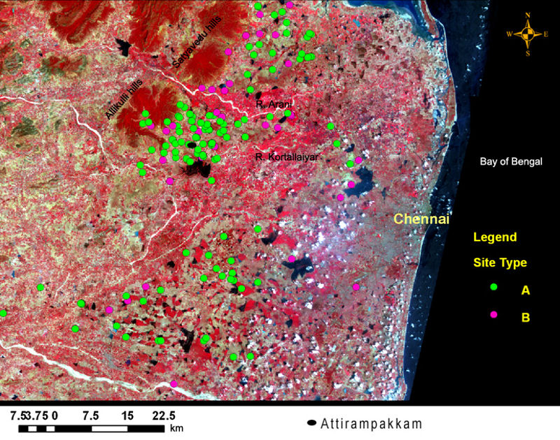
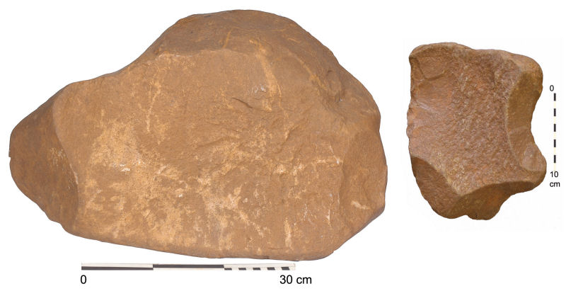
Acheulean occupation was predominantly clustered in the north-west and northern parts of the study region (95 sites within 82 complexes); primarily owing to the proximity of quartzite cobbles and boulders. A few scattered artefacts, however, are noted further south of the River Palar (Figure 3). This pattern is also conditioned by the distribution of exposures of Lower to Middle Pleistocene sediments. Acheulean 'quarry' sites were discovered, with very large to giant quartzite cores (Figure 4). In addition to multidirectional and bifacially flaked cores, prepared cores for detaching flakes for cleaver manufacture were also noted. The Kombewa technique was seen. At sites lacking raw material, Acheulean hominins transported large flakes and bifaces in various stages of reduction, across the landscape. This is clearly seen in excavations of the earliest Acheulean levels at Attirampakkam, pointing to a fragmented reduction sequence.
Satellite image showing close up of the northern part of the study region and distribution of prehistoric sites, including Attirampakkam.

Acheulean giant and large cores.

Transitional phases are marked by: a decrease in bifaces, increased adoption of Levallois techniques and an increase in the smaller flake tool component, which eventually characterised the Middle Palaeolithic. Evolution of strategies to detach flake-blades and blades can be traced from the Late Acheulean and early Middle Palaeolithic onwards.
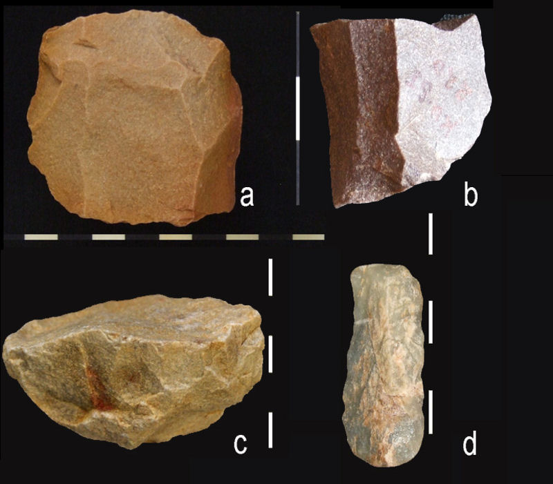
Middle Palaeolithic sites (133 sites within 119 complexes) occur over the entire study region; a greater range of raw material types including chert and chalcedony were exploited; and artefacts were transported across distances of over 40km (Figure 5). An evolution of technology for production of blades and flake-blades along with a microlithic component is noted from the Late Middle to early Late Palaeolithic onwards. Luminescence dates from one very late site yielded an age of c. 63 kya (Pappu et al. 2009b).
Middle Palaeolithic: a) Levallois core. Late Middle Palaeolithic artefacts: b) blade core; c) unidirectional single platform core for detaching elongated flakes/flake-blades & d) blade.

The number of Late Palaeolithic assemblages (having a greater blade component, lacking Levallois techniques and with a microlithic element) is lower, with only 43 such sites in 34 complexes. This decline is also seen in the sparse sites of this period which are truly microlithic. The Late Palaeolithic assemblages are scattered over the entire study region. The period has predominantly flake tools, but has a greater standardisation in blade technology and a microlithic component, with silicified wood also being used.
Specific sites were often occupied through time, in particular by both Acheulean and Middle Palaeolithic groups, while Late Palaeolithic populations largely preferred different ecological zones. Satellite remote sensing helped identify raw material sources, and field studies aided in studying the nature of clasts. These were useful in addressing issues related to site distribution and technological strategies followed.
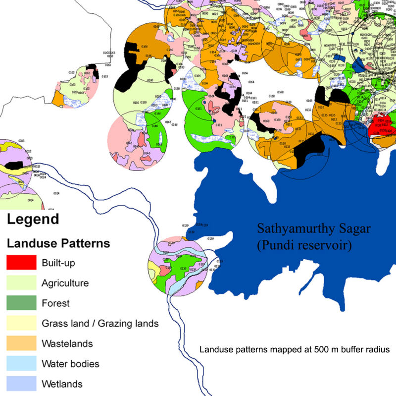
For purposes of heritage management, the nature, intensity and area of modern landuse patterns impacting sites were quantified using satellite images. This was done at several levels — at the exact site area, and within buffer radii of 50m, 500m and 1km around the site — to assess immediate and potential impacts. This was supplemented by field observations (Figure 6). Impact indices aided in the classification of sites based on their level of destruction. Overlays of georeferenced village cadastral maps on rectified high resolution IKONOS data provided exact landuse and ownership details, to suggest site-specific conservation strategies. A model to identify new areas where sites may be located was proposed and tested in the field, leading to the discovery of new sites. Ongoing research in this region supplemented by studies in southern Tamil Nadu will aid in a better understanding of the prehistory of this part of south India.
Modern land use patterns (500m buffer radius) affecting prehistoric sites around the Sathyamurthy Sagar reservoir.

Acknowledgements
This project was funded at various points in time by the ISRO-GBP program, Earthwatch Institute, Leakey Foundation, Homi Bhabha Fellowships Council and Sharma Centre for Heritage Education, for which we are very grateful. We thank the Archaeological Survey of India and the State Department of Archaeology, Government of Tamil Nadu.