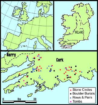
Monuments examined in the survey.

This is a brief summary of the results of the first comprehensive survey analysing optimal site placement of a defined geographical group of monuments in terms of the astronomical properties of the entire horizon profile. Ruggles has in the past (1983) commented that such an approach was potentially useful but at the cost of an enormous amount of fieldwork - he was correct on both counts. The findings have important consequences for our understanding of prehistoric north-west European societies and their use of landscape.
The primary survey was carried out on the Cork-Kerry Stone Circle Complex of monuments, which has been dated to c. 1650 - c. 800 BC, main types being Five Stone Circles, Multiple Stone Circles, Boulder-Burials, Short Stone Rows and Standing Stone Pairs. To date, 23 per cent of the known total have been surveyed. All conform to the patterns described below without exception.
In his study of indicated alignments, Reference ThomThom (1967) claimed that celestial phenomena were measured against the horizon and that the solar year had been split into 16 parts of about 23 days each. It can now be shown that he was correct but it was done by repeated halving of time intervals, with no attempt to modify the natural length of the periods as he suggested. Furthermore, it is now clear that monument axes are secondary indicators, the primary purpose of the monument being to mark a multi-directional observing position (Figure 2).
Sunset positions of the 16 part solar cycle: EQ = equinox. Ssol = summer solstice. SXQ = summer cross-quarter = half the EQ to Ssol time interval. SXQ/Ssol = half the SXQ to Ssol interval. EQ/SXQ = half the EQ to SXQ interval. EQ/WXQ = half the EQ to WXQ interval. WXQ = winter cross-quarter = halfway between EQ and the winter solstice (Wsol).

Note that the illustrated piece of horizon is only a part of that used and is not indicated by the monument axis, which is in fact lunar. Excavation of this site (Reference LynchLynch 1999) exposed features for which there is no orthodox explanation that are entirely consistent with the setting out work required to locate the row accurately in relation to the landscape (Wilson in prep).
The sun, for practical purposes, always has the same north and south limiting positions while those of the moon expand and contract in a predictable manner over an 18.6 year period. Reference ThomThom (1967) also claimed that these limits of the lunar node cycle, which he named the Major & Minor standstills, were observed. He was right again, but repeated recurrences of particular data values in this survey have consistently shown that the lunar cycle was, like the solar cycle, split into 16 parts (figure 3).
The Maughanasilly row could have been used again to illustrate this point but Scartbaun is a bit more spectacular and helps demonstrate that all sites are doing the same things. Note that in this case there are no markers for the sixteenths adjacent to the limiting positions, the difference there being only three-quarters of a lunar diameter. This is quite common but there are many sites that make it clear that the sixteenths adjacent to the limits were intended and some specialise in emphasising that small difference.
Setting positions for the most southerly moon of the month over the 18.6 year lunar node cycle: Max = Major standstill. Min = Minor standstill. Mid = midpoint = half the time interval between Max & Min, splits the cycle into four parts. Min8 = one eighth of the cycle on the minor side. Maj8 = one eighth of the cycle on the major side. 1/16 = a sixteenth of the cycle.

Axial indication of the sunset position marking the limits of a month centred on the Winter Solstice. The axial reverse direction indicates Max moonrise to the north-east.

Horizon for observing the most southerly moon of the month and relating it to the solar cycle: When moonset is in the zone around Min8, eclipses can only happen when the sun is between WXQ-15 & WXQ+15 (and SXQ-15 to SXQ+15). When it is on the lower hillslope around 1/16, eclipses can only happen when the sun is between Wsol+8 & WXQ-8 (and SXQ+8 to Ssol-8). When it is in the zone around Mid, eclipses can only happen in the month centred on the winter solstice, which is a small zone around Wsol+8 (and the month around Ssol).

Another unexpected set of data values repeatedly recurred, that appeared to mark days about one or two weeks from the major solar events. When this data was rationalised, it could be seen that each of the solar sixteenths had been bracketed by periods of half a month either side. The brackets for the major solar events have been labelled as +15 & -15 (days). e.g. EQ+15 & EQ-15 are the limits for a month centred on an equinox. Because the sun reverses direction at the solstices, the same marker defines both half a month before and after a solstice (figure 4).
As each sixteenth part of a year is nominally 23 days long, 15 days from one end is 8 from the other. For this reason, and to simplify the labelling system, the 15 day brackets for the sixteenths are labelled as 8 days from the adjacent equinox, solstice or cross-quarter (figure 5).
Why divide up the solar and lunar cycles in this way? Because it is a clever way of reconciling them with each other. Each of the 16 divisions so far discussed really represents the centre of a period and there is an inverse relationship between the two cycles thus: During the 1.16 (18.6 / 16) year period centred on the midpoint of the lunar cycle, visible eclipses can only occur during a synodic month centred on a solstice. During the period centred on either a major or a minor standstill (Max or Min) visible eclipses can only occur during a synodic month centred on an equinox. Likewise, the lunar eighths correspond with months centred on the solar eighths (cross-quarters) and the same for the sixteenths (figure 5).
This monument marks a site that has calendrically useful skylines in all four quadrants. A post-construction activity horizon has been dated to 2316-1784 cal BC 2-sigma.

More recently, a survey of four Wedge Tombs has shown that they too were all sited to meet the same criteria. The one at Altar has been excavated and a date obtained (O'Brien 1999: 131-135). Therefore, it is now possible to say that by 2000 BC, megalithic society in NW Europe was using a fully evolved system of horizon astronomy to map and measure the solar and lunar cycles for the purpose of eclipse prediction (figure 6).
Obviously, no horizons are perfect, and a certain amount of estimation and counting was involved. In general, the marked positions are precise to around 0.1 degree, i.e. at the limits of practical possibility. It is very unlikely (and demonstrably so) that such consistent relationships could have occurred at every surveyed site by chance. Formal statistical analysis is not simple and has yet to be attempted, but how could the data have been influenced to manufacture a method of eclipse prediction that was, prior to this study, both unknown and unsuspected?