

Introduction
Most of the High Arctic is a polar desert (Reference Serreze and BarrySerreze and Barry, 2005) where water is limited and the ecosystem is stressed by water scarcity during the summer. Life is concentrated in areas where water is available. Scattered on the landscape are semi-permanent snowpacks, which normally persist for decades or longer (e.g. Reference Young and LewkowiczYoung and Lewkowicz, 1990; Reference Brown and WardBrown and Ward, 1996). The snowpacks consist of late-lying snow that lingers on after the seasonal (winter) snow cover has disappeared from the general area. They are often missed by satellite imagery due to its coarse resolution and the frequent low cloud conditions in the High Arctic, which in combination limits their surveillance (Reference Fontana, Trishchenko, Luo, Khlopenkov, Nussbaumer and WunderleFontana and others, 2010). These snowpacks occupy only ~–5% of the Arctic land (Reference Serreze and BarrySerreze and Barry, 2005, p. 32) but comparable features are found in alpine zones of temperate latitudes (Reference Glazirin, Kodama and OhataGlazirin and others, 2004; Reference Fujita, Hiyama, Iida and AgetaFujita and others, 2010). Despite their limited size, these snowpacks are widely distributed, delivering meltwater throughout the summer to sustain both surface and subsurface flows, which become precarious after the spring freshet in the polar desert. Like little oases, areas around semi-permanent snow where runoff concentrates become focal points for vegetation growth, which provides principal habitats and food sources for insects, birds, rodents and even larger animals.
The extreme warm Arctic summers of 2011 and 2012 caused marked shrinkage and even the loss of many semipermanent snowpacks, a phenomenon that echoes the general pattern of drastic reduction in the extent of spring snow cover on a global scale, as reported by Derksen and Brown (2012). The demise of semi-permanent snowpacks places them in a precarious position that not only diminishes their runoff contribution to the dry environment, but also jeopardizes the health of the ecosystems adjacent to them. This paper examines the recent evolution of semi-permanent snow at several sites in the Canadian High Arctic, and the effects of its decline on the thermal condition of the active layer (i.e. the seasonally frozen and thawed zone atop the permafrost), the hydrological and ecological well-being of wetland patches frequently found dispersed on the arid land, and the water balance of headwater basins that normally retain late-lying snow. We draw upon examples from an intensely studied field site, together with additional observations and information reported from other parts of the Canadian Arctic Archipelago.
Study Area And Methods
Two forms of semi-permanent snow storage are common in the High Arctic: snow beds on topographic concavities of hillslopes, and snow banks held within stream valleys (for convenience of discussion, they are hereafter labeled separately as snow beds and valley snow banks). Detailed investigation of several semi-permanent snow sites was carried out near Resolute (Qausuittuq), Cornwallis Island, Nunavut, Canada, over a period of decades (Reference Woo and SauriolWoo and Sauriol, 1980; Reference WooWoo, 2012, p. 423–424) (Fig. 1). The distribution and configuration of valley snow banks in a 30 km2 area were observed by photographing the snow at a number of valley sites and by examining satellite images available in Google Earth (Fig. 2). A comparison of Figures 1 and 2 indicates the loss of late-lying snow. For one selected snow bed on a hillslope (studied since 1996; Reference Young and WooYoung and Woo, 2003) the snow depth was probed along several transects and the density of the end-of-winter snow on the ground was obtained using a Meteorological Service of Canada snow sampler. The snow-bed profile was surveyed repeatedly with a tape measure, Wild Level and stadia rod during several summers, either numerous times over the summer season and/or in early or late August prior to freeze-back. Seasonal and end-of-summer photographs were also taken to document shrinkage and expansion. In 2012, basal ice density (kg m–3) was determined. Five ice samples each ranging from 20 to 40 cm3 in volume were obtained with an ice pick and then weighed on an electronic scale (±0.1 g). The active layer thickness in the wetland area downslope of this snow bed, represented by maximum ground thaw attained at the end of summer (prior to freeze-back), was obtained by pushing a steel rod into the ground until penetration was halted by the permafrost. In total, between 25 and 30 frost table measurements were made over an area of 25 m × 200 m. Ground thaw was monitored near water wells lying along four transects extending from the snow bed to the edge of the wetland (Reference Young and WooYoung and Woo, 2003). The distance between water pipes was 20–25 m. Spatial analysis of maximum ground thaw was originally completed with Surfer-81 software, but was abandoned because of spurious patterns arising from outliers. Contours were eventually hand-drawn by visual inspection, an approach that drew upon our long-term field experience at this site. Changes in vegetation were recorded over a period of years following a stratified random approach (Reference Mueller-Dombois and EllenbergMueller-Dombois and Ellenberg, 1974). In 1999, percent plant cover was obtained here with a sampling vegetation quadrat (a wooden frame of known area) subdivided into smaller grids. In the wetland zone the quadrat size was 0.2 m × 0.5 m, with a sample size of n = 10. In the adjacent non-wetland area the quadrat was 0.5 m × 0.5 m in area and n = 10. A comparable method was used in 2012, except a 0.5 m × 0.5 m quadrat was used for both the wetland and non-wetland zones. For another patchy wetland in Resolute, located ~135 m to the northwest of this wetland (Fig. 2), the extent of late-summer flooding was estimated using ArcGIS, water-level data and the digital elevation map of the site. These flood patterns were also verified on the ground (Reference Woo and YoungWoo and others, 2006). The detailed digital elevation map was produced earlier from a topo-graphic survey of this wetland and its adjacent areas in 1997. Several perforated pipes (~35) were installed in the wetland to serve as groundwater wells spread across seven to eight transects. Manual measurements of the water table were made at approximately daily intervals over several summers (Reference Woo and YoungWoo and others, 2006). In late August 2012, near-surface flooding at this wetland was mapped from photographs and estimated using ©Adobe Photoshop (pixel count). At Polar Bear Pass, Bathurst Island, Nunavut, the water level of two tundra ponds was recorded with Hobo pressure transducers (±30 mm precision), and checked periodically with a metric ruler in summer 2007.
Aerial photograph of main study area in Resolute, Nunavut, Canada, dated 25 July 1958, with semi-permanent snow banks (white lines and patches) on hillslopes and in stream valleys in a polar desert setting (Air Photograph A1619A-112, National Air Photo Library, reproduced with permission from National Air Photo Library, Natural Resources Canada). The snow bed studied for multiple years is circled. Inset shows the Canadian Arctic Archipelago with locations mentioned in the text.


Ground observations and aerial surveys were also made on other islands of the Canadian Arctic Archipelago. Air temperature was taken from official weather stations of the Meteorological Service of Canada and obtained from our field site in Polar Bear Pass. Air temperature (at 2.5 m height) at Polar Bear Pass was measured with a Campbell Scientific probe (±0.2°C). Daily winter precipitation (September–May) was taken from an adjusted and homogenized Canadian climate dataset (AHCCD) available at http://www.ec.gc.ca/dccha-ahccd/ (Reference Mekis and VincentMekis and Vincent, 2011). Summer daily precipitation at Polar Bear Pass was measured with a Campbell Scientific tipping-bucket rain gauge (±0.25 mm) supplemented by manual gauges (±1 mm) (Reference Young and LabineYoung and Labine, 2010).
Evolution Of Semi-Permanent Snow Cover
The mass balance of a snow bank or snow bed governs its growth and decline. At the end of the summer of year t, the storage status (S) of a snow mass is related to the snow left from the previous year (t – 1), plus the net of annual snow accumulation (P) and ablation (M):
with S(t) ≥ 0.
Accumulation is achieved through winter precipitation and snowdrift deposition, and ablation occurs through melting, sublimation and mechanical erosion of the snow. With seasonal snow cover, S(t) always reaches 0 by mid- to late summer, and rebuilds every winter. For glaciers, S(t) is always positive, as the substantial storage of ice mass buffers against complete depletion, even for centuries. Semipermanent snow is subject to considerable interannual variations in S(t), and its persistence is between seasonal snow and glacier ice. In this regard, such snow may be considered to hold an intermediate position in the snow– glacier continuum (Reference Glazirin, Kodama and OhataGlazirin and others, 2004) and, where sheltered by topography, snow banks may be preserved or even form small glaciers (Reference DeBeer and SharpDeBeer and Sharp, 2009).
Blowing-snow events occur frequently across the treeless and windswept terrain during the long and intensely cold Arctic winters. Prevailing wind interacts with topography to produce a recurrent pattern of snow deposition. Topographic depressions, including slope concavities and incised valleys, are favourable positions where snowdrifts are deposited, with the snow sometimes thickened by the formation of cornices (Fig. 3). Where the snow is deep, it covers most ground irregularities to present a smooth or gently undulating surface, but snow depth can also vary within segments of a valley or hillslope to create snow ridges and troughs. The distribution pattern of snow deposition recurs every winter (Reference Woo and SauriolWoo and Sauriol, 1980; Reference Sturm and WagnerSturm and Wagner, 2010), but varies in magnitude between years, depending on winter precipitation and variability of high wind speed events. Thick snowdrifts are produced at the same sites, which become preferred locations for the formation of semipermanent snow.
When the accumulated winter snow melts in the spring, the percolated meltwater encounters intensely cold ground or a pre-existing bottom ice layer of subzero temperatures. Meltwater then refreezes to form basal ice (Reference Woo, Heron and MarshWoo and others, 1982). The formation of this ice is basically the same as that of superimposed ice on glaciers, which is common on polar ice caps (Reference KoernerKoerner, 1970). For the snowpacks, the term basal ice is preferred as it is found at the base of the seasonal snow cover rather than superimposed on the glacier ice surface. If not entirely melted in the summer, this basal ice is incorporated as a new layer within the snowpack, which then acquires semi-permanency (Fig. 4). The core of a snow bed is built up by multiple years of repeated basal ice growth and this ice can be rather old. For instance, Lewkowicz and Harry (1991) cored a semi-permanent snow bed near Ross Point on Melville Island and found the basal ice at 2 m depth predated 1957. When first formed, basal ice attains a density of ~750 kg m–3 (with a range of 645–803 kg m–3, based on five measurements made in 2012), whereas the overlying wind-compacted seasonal end-of-winter snow has an average density of 250–350 kg m–3 (Reference WooWoo and others, 1983).
Semi-permanent snow is subject to variations in accumulation and ablation depending on vagaries of climate. Snow beds are first melted from the surface, beginning with the seasonal snow, followed by the multi-year ice below. Radiation is the main energy source, and topography plays a key role in affecting the melt rate, which is much lower on north-facing aspects and in shaded areas. These zones therefore favour the preservation of late-lying snow. High air temperatures not only raise the longwave radiation input to the snow, but also increase the sensible heat flux. When bare ground is exposed after the loss of the seasonal snow cover, snow beds experience accelerated melting as heat is advected from their edges (Reference Young and LewkowiczYoung and Lewkowicz, 1990; Reference Neumann and MarshNeumann and Marsh, 1998). Thus, snowmelt increases in warm and long summers, especially when accompanied by diminished cloudiness to enhance radiation melt. In addition to melt events, surface erosion by snowmelt water and summer rainfall accelerates ablation of the snow, leaving its surface scalloped or carved by rills.
(a) Semi-permanent snow beds on hillslopes in southwestern Ellesmere Island, Canada. Snowmelt produces summer runoff on slopes, as seen below the snow bed at the front. (b) Semi-permanent snow banks remaining in a valley near Resolute at the end of a relatively cool summer (20 August 1978) when the valley was smeared with the first winter snow.

Compared with snow beds on slopes, semi-permanent snow in stream valleys is subject to additional agents of ablation, which include erosion by the streams and collapse of steep or overhanging snow masses (Fig. 3b). These processes are particularly active under high flow in the channels, a condition that prevails in the spring. After the freshet, most of the valley snow that is not removed is subject only to the same surface ablation processes as the late-lying snow beds on hillslopes. Ablation activities terminate at the end of summer, and new snow accumulates again on top of the residual snow to repeat the cycle of snow-bank evolution.
Cross section of a snow bed in Polar Bear Pass, Bathurst Island, Canada, showing basal ice formed by refreezing of snowmelt water at the bottom of winter snow cover. The exposed profile of the snow bed reveals layering in both the basal ice (0.15 m thick) and its overlying seasonal snow.

Results
Recent changes in semi-permanent snow
Field observations and satellite imagery suggest shrinkage or disappearance of semi-permanent snow in the High Arctic in recent years. Changes of a semi-permanent snow bed in Resolute are examined in conjunction with climatic records available at the nearby official weather station. Winter snowfall recorded at the station is used as an indicator of snow accumulation. The percentage coverage of snow beds on hillslopes at the beginning of each summer (i.e. after the seasonal snow is depleted from the general area) varies between years, reflecting the condition of winter snow that is added onto the residual snow left from the previous year. The rate of ablation also varies, producing late-summer snow profiles that differ between years (Fig. 5a). The temperature-index method is used widely to assess melt (Reference HockHock, 2003). While this approach is applicable to specific sites where temperature is measured, we use it here to indicate melt change in relative terms between different time periods and scales. Using winter snowfall data from Resolute weather station to approximate annual variations in snow accumulation, and positive degree-days (PDDs; the sum of daily air temperature >0°C) for June–August as an indicator of snow ablation on a seasonal scale, these climatic variables are compared with the percentage coverage of the study snow bed at the end of past summers (Fig. 5b).
(a) Late-summer profiles of a semi-permanent snow bed in Resolute; (b) PDDs and winter precipitation for Resolute weather station (1996–2012) and percentage snow coverage of the snow bed in late summer of several observation years; and (c) shrinkage of the snow bank in the course of several summers.
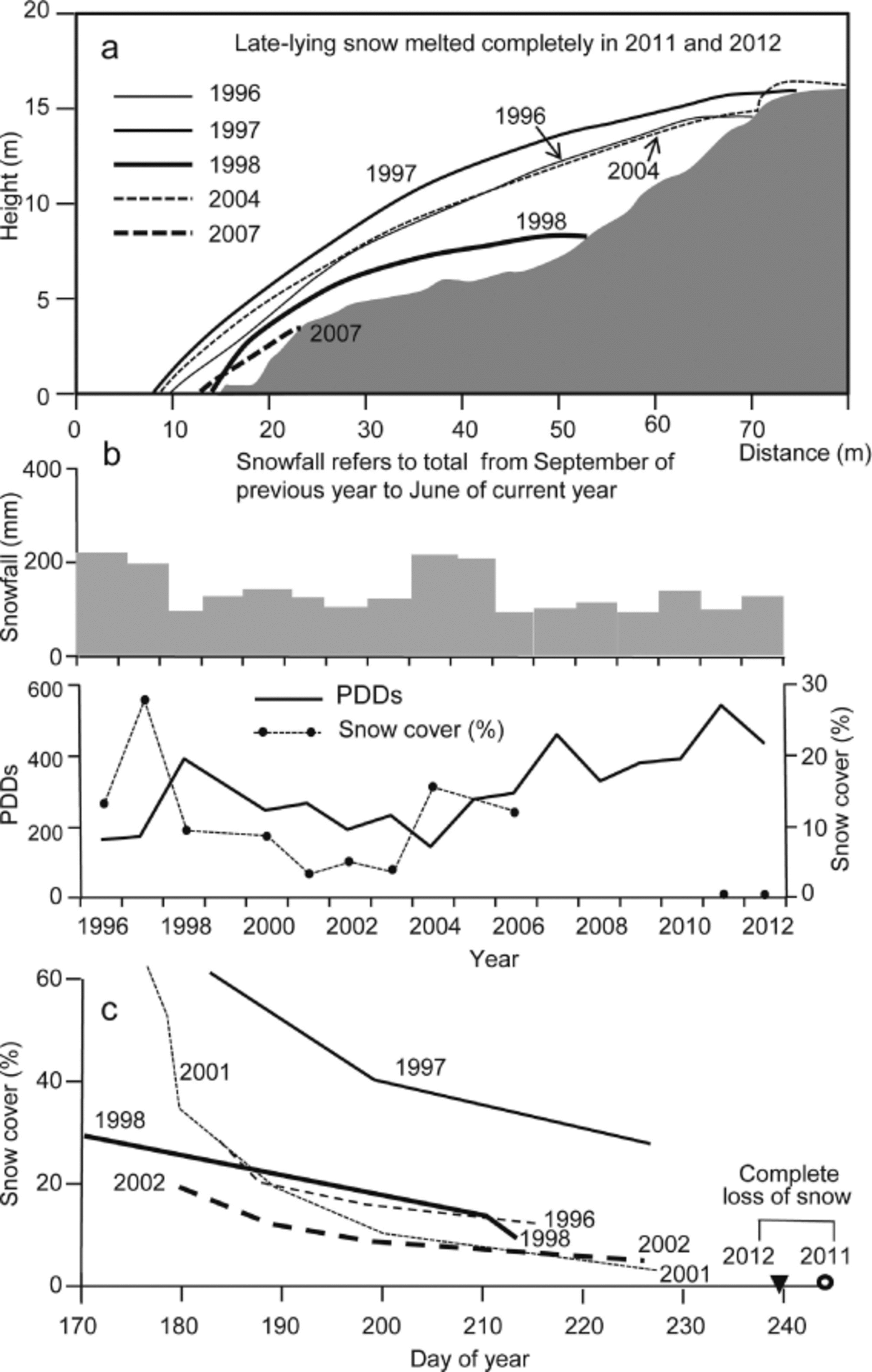
For almost all years since the 1950s, multi-year ice was largely preserved at the end of the summer. In years with a cool summer, there was ice growth for the snow bed. Notable increases occurred after winters with heavy snowfall, for example in 1997 when the snow bed with its winter snow layer initially occupied 61% of the slope surface. Melting then shrank it to 27% at the end of that cool summer (Fig. 5c). Low snowfall in the 1997/98 winter was followed by a warm summer in 1998, which experienced anomalously high temperatures accompanied by a long summer season across the Canadian Arctic (Reference AtkinsonAtkinson and others, 2006). Early melt in 1998 reduced the mid-June snow cover to 30%, followed by a dramatic contraction during the summer, leaving behind a residual snow-covered area of only 10% by the end of July (Reference Young and WooYoung and Woo, 2003). By 18 July, the snow bed was reduced by 2.4 m (1.1 m snow water equivalent (SWE)), a value that contrasts with the 1996 ablation amount of only 1.2 m (0.6 m SWE) on the same date. During summer 1998, not only did the seasonal snow melt completely, but part of the underlying pre-existing multi-year ice also underwent severe attrition, yet the snow bed survived due to the sizeable storage inherited from 1997.
Heavy winter precipitation (211 mm w.e. of snowfall) followed by a cold spring and cool summer (the second coldest since 1953) helped to rebuild the snow bed in 2004. However, it lacked the substantial base of multi-year ice that was mostly removed in 1998. A series of warm years followed, in a period when the spring snow-cover extent of North America experienced a steep decline and the Arctic Ocean witnessed the most unprecedented loss of multi-year and total sea-ice extent since satellite records began (Reference ComisoComiso, 2012; Reference Derksen and BrownDerksen and Brown, 2012). The June– August PDD at Resolute also increased, and the snow bed underwent continual degradation. In 2011, a record number of PDDs (540 compared with a 60 year mean of 256) completely melted the study snow bed, and its underlying ground topography emerged for the first time in at least half a century. All but a few patches of semi-permanent snow (both on hillslopes and in the valleys) in the Resolute area similarly disappeared and they were not re-established in 2012, which also had a high number of PDDs (430).
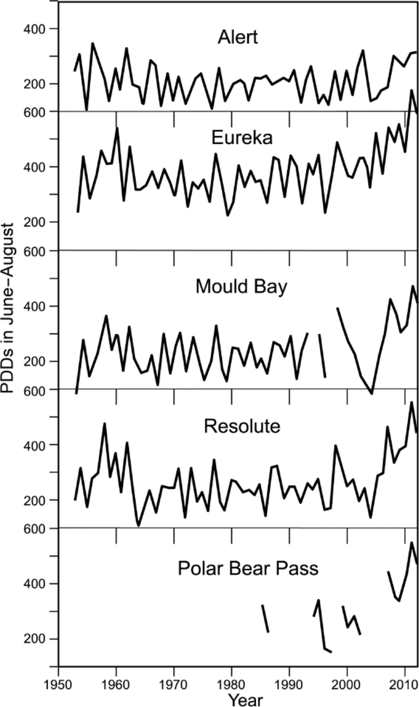
Summer warming has been a common occurence in the Canadian High Arctic in recent years, as demonstrated by the PDD records for weather stations (Fig. 6). Comparing 5 year averages for the periods 1978–82 and 2008–12, the number of PDDs for Resolute (74°43’ N, 94°58’ W) increased from 217 to 410, for Alert (82°31’ N, 62°17’ W) the increase was from 200 to 291, at Eureka (79°59’ N, 85°56’ W) PDDs increased from 318 to 553, and at Mould Bay (76°14’ N, 119°20’ W) the number of PDDs increased from 195 to 382. Our measurements made at Polar Bear Pass (75°40’ N, 98°30’ W) similarly showed an increase, from 276 (1985– 86 mean) to 424 (2007–12 mean) PDDs. Extensive warming in the High Arctic results in the disappearance of semipermanent snow, a tendency that is in agreement with intensified melt of glaciers in the Canadian Arctic islands (Reference FisherFisher and others, 2012; Reference Lenaerts, Van Angelen, Van den Broeke, Gardner, Wouters and Van MeijgaardLenaerts and others, 2013) including Penny Ice Cap, Baffin Island, Nunavut (Reference ZdanowiczZdanowicz and others, 2012), which experienced positive summer and winter air temperature anomalies that exceeded those of the late 1940s and early 1950s.
Effects on ground thaw and permafrost
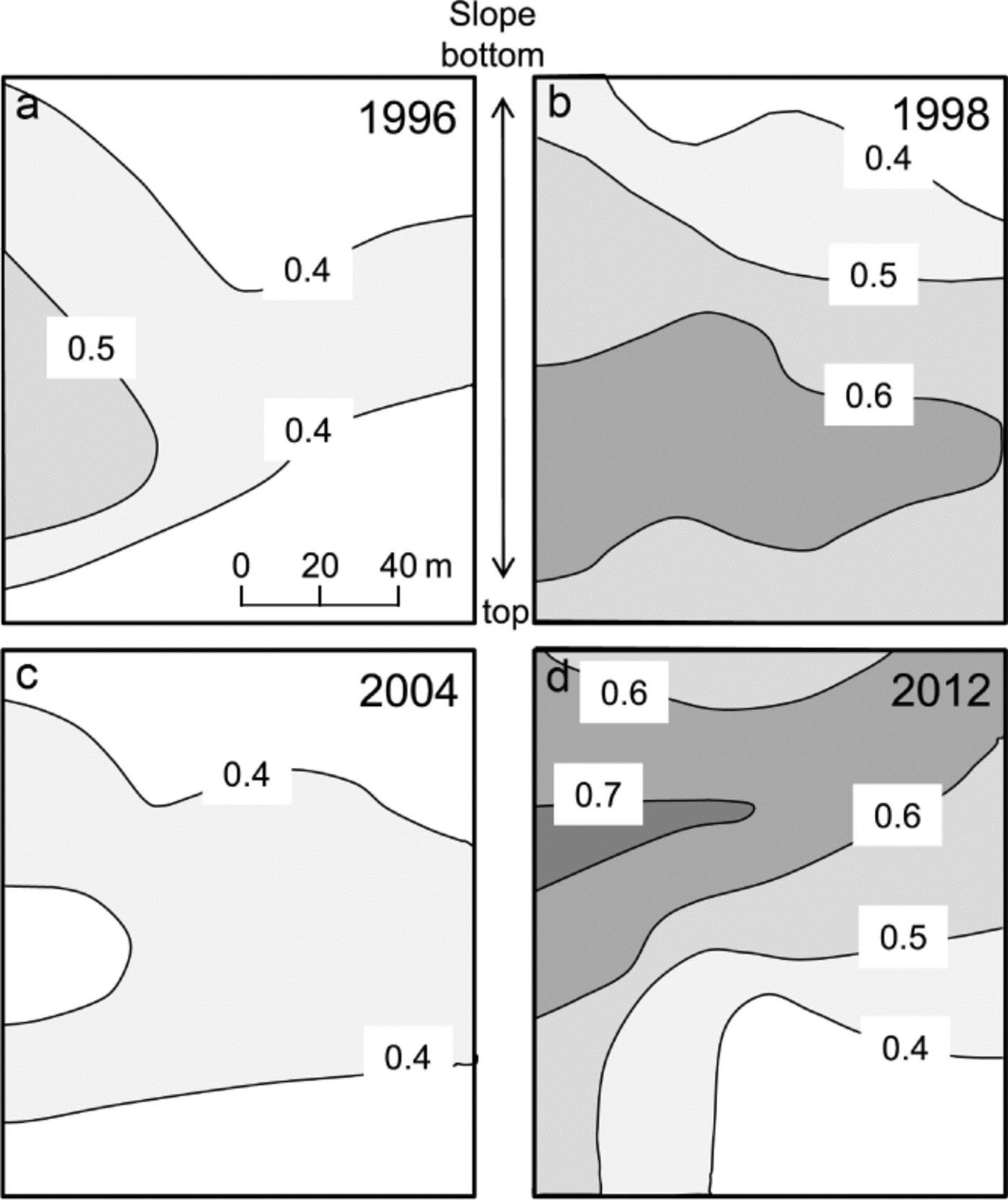
In permafrost regions, changes in the semi-permanent snowpacks affect both the ground thermal state and the hydrologic conditions of the sites they occupy, as well as the adjacent areas. The snow keeps the underlying ground at subzero temperatures. Where the snow becomes perennial, its underlying permafrost rises to the ground surface and the active layer (the seasonally thawed zone above the perma-frost) is absent. Otherwise, the thickness of seasonal ground thaw depends on (1) how long the snow lingers on the ground, (2) how warm the snow-free season is, (3) how much heat is conducted into the ground, which is a function of the thermal property of the soil, and (4) how much ground ice the soil contains, because for ground thaw to reach a particular depth, the latent heat demand is larger for an ice-rich than for an ice-poor soil. As the margins of a snowpack retreat during the summer, the exposed ground is warmed and the ground ice therein is subject to melting. The edges of a snowpack become snow-free for a longer period and receive more heat than its interior, and therefore they can potentially have greater thaw. In an exceptionally warm year with long exposure of the ground to summer heating, the thawing front penetrates deeper than normal and melts the subsurface ground ice that has formed over the past years.
These processes are illustrated by the developmental history of a study plot below a semi-permanent snow bed. Before 1998, the median active layer depth was 0.37– 0.42 m. At the end of the very warm summer of 1998 (with 388 PDDs), the median depth increased to 0.55 m (Fig. 7). An ice-cored mound measuring 24 m2 and rising 0.55 m above its surrounding ground surface underwent deeper than normal thaw. This mound collapsed as its ground ice melted, subsiding by 0.13 ± 0.07 m (Reference Young and WooYoung and Woo, 2003). The mound continued to decay in the following years as more ground ice melted. It disappeared completely by 2003 and has not re-established since. This phenomenon suggests a long-term effect that the concentration of ground ice, once eliminated, takes years to redevelop.
Hydrological effects
The presence of late-lying snow yields meltwater over the entire summer period, thereby sustaining runoff to the arid polar desert. Wetlands, ponds and streams benefit from the extended duration of water supply, an advantage that is diminished or lost as the semi-permanent snow cover shrinks or disappears.
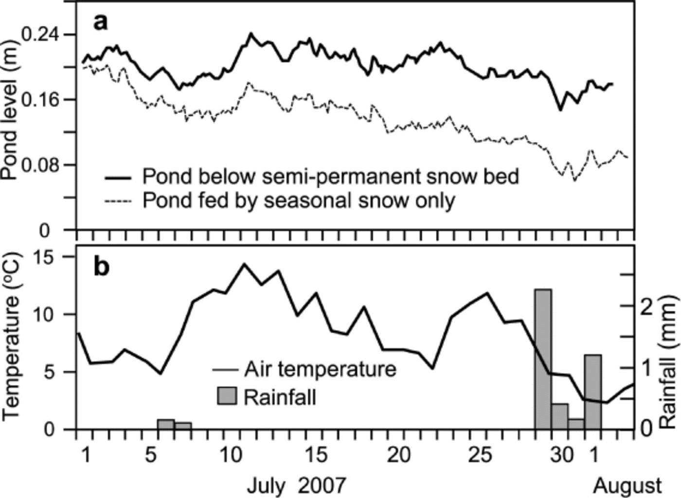
Most ponds and wetlands in the polar desert owe their existence to focused surface and groundwater discharge when the ground dries out after the spring freshet (Reference Woo and YoungWoo and Young, 2006). With limited summer rain, meltwater from late-lying snows is often the principal source of runoff. The role of this water source in support of tundra ponds is demonstrated by the fluctuations of water level of two tundra ponds located 20 km apart at Polar Bear Pass. One of the ponds is below a semi-permanent snow bed, which through snowmelt supplies surface and subsurface flows to the pond, while the other does not have such an advantage. Figure 8 shows the water level of these two ponds during summer 2007. Rainfall was low during that summer so, after the spring, evaporation was chiefly responsible for drawing down the level of the pond without replenishment from a late-lying snow bed, but the pond below the semi-permanent snow received continued lateral inflow of meltwater, which compensated for evaporation loss. The level of the latter pond remained steady throughout the summer.
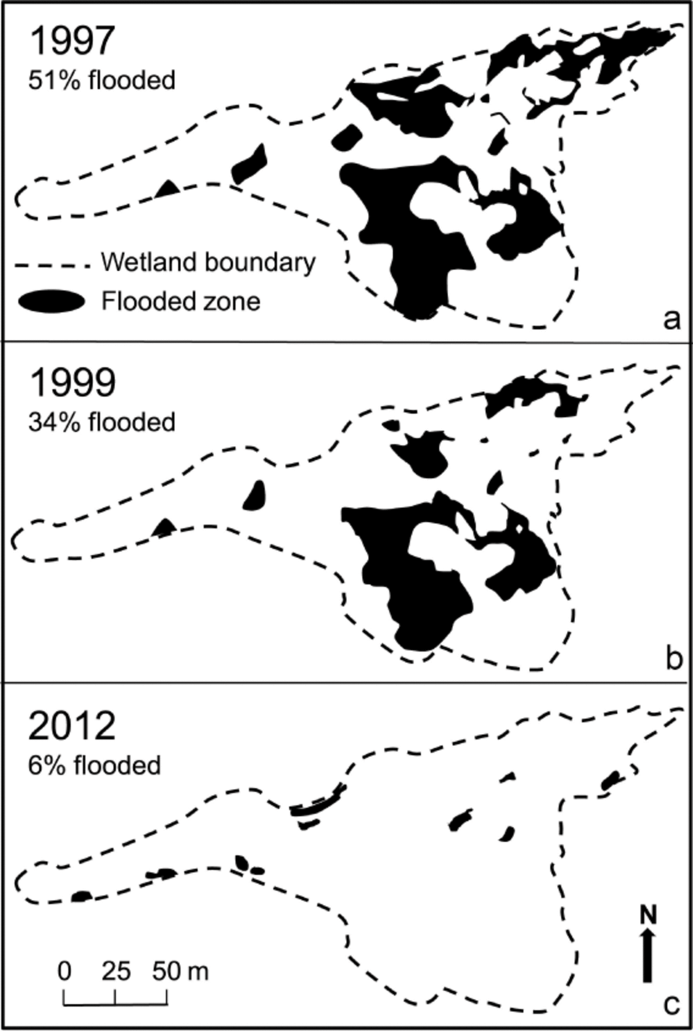
In addition to supporting surface flow, meltwater may seep into the thawed active layer and discharge lower downslope, re-emerging in some local depressions to support patchy wetlands. One groundwater-fed wetland in Resolute relies mostly on such groundwater discharge. A comparison of end-of-summer flooding conditions confirms the role of meltwater supply. Figure 9a shows the flood extent in 1997, a pattern that is commonly observed in most years. The following summer was exceptionally warm and there was considerable shrinkage of the snow bed feeding the wetland. However, the extent of flooding showed no noticeable change because the reduced snow bed was still able to yield enough meltwater to feed the wetland through the ground-water route. The drying effect became apparent in 1999 when the snow coverage was further reduced and could not provide sufficient water to maintain the usual flooding of the wetland (Fig. 9b). Conditions became more extreme in 2012 when, after the snow bed faced complete depletion for two summers, the loss of meltwater input to the groundwater led to notable desiccation of the wetland (Fig. 9c).
June–August PDDs during the period 1953–2012 for weather stations in the Canadian High Arctic.
For small drainage basins, semi-permanent snow is a form of storage that retains the precipitation from a high snowfall year to support basin runoff and evaporation losses in a low precipitation year. The water balance of McMaster River basin in Resolute for a 6 year period with a range of precipitation amounts (Table 1) can be cited as an example to demonstrate the interannual changes in storage (Reference Woo, Heron, Marsh and SteerWoo, 1983). During this period, there were years when basin storage was negative. In the absence of any other water source, semi-permanent snow banks are the only plausible provider of water that runoff and evaporation can draw upon to balance their excess over precipitation. Thus, a negative storage change such as in 1976/77 implies that water was withdrawn from semi-permanent snow banks to cover the deficit, whereas a positive change such as in 1977/78 indicates that an excessive amount of precipitation not used up by runoff and evaporation was accrued to the snow banks.
Maps showing maximum (end-of-summer) frost table depth (m) below a semi-permanent snow bank in Resolute for (a) 1996 (cool year), (b) 1998 (warm year), (c) 2004 (cool year) and (d) 2012 (warm year).
Vegetation change
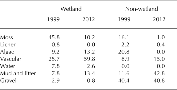
Diminished water supply associated with continual shrinkage of semi-permanent snow cover gradually causes the normally saturated sites to be deprived of the moisture necessary for the maintenance of their vegetation cover, leading to changes in the local eco-environment. The plant cover of the patchy wetland studied (Fig. 5) and its adjacent non-wetland site was documented over the period 1998– 2012 to quantify the changes (Table 2). In 1999, 1 year after an exceptionally warm and dry summer, changes began to occur in the composition of vegetation and the extent of wet areas. By 2012, after years of gradual deterioration of the semi-permanent snow bed that provided groundwater to feed the wetland, a reduction in flooded area (indicated by percentage of water) was accompanied by increases in mud and litter surfaces at both the wetland and non-wetland zones. Vascular plant percent cover increased, while algae coverage increased in the wetland but not in the non-wetland areas. Field observations in late August 2012 showed that grasses stood 0.41 m tall in comparison to sedges (0.23 m). It is surmised that with continued drier conditions the ecological status of these wetland patches could change.
(a) Water-level variation of two tundra ponds in Polar Bear Pass during summer 2007. One pond lies below a semi-permanent snow bed and received meltwater throughout the summer to compensate for evaporation loss. The other pond without this source of water supply declined gradually after the seasonal snow was depleted. (b) Daily temperature and precipitation in this period.
Annual water balance of McMaster River basin (area 33 km2). Storage change is calculated as P –(Q + E). All values in mm. After Woo (1983)

Changes in composition (%) of a patchy wetland and its adjacent non-wetland site between 1999 and 2012
A change in vegetation or plant cover implies: (1) an increase in the availability of nutrients provided by a deeper frost table (Reference Tape, Sturm and RacineTape and others, 2006); (2) a build-up of dry and decaying litter with the potential to enhance ground insulation; (3) alteration in wetland evaporation through shrinkage of open water surface but enhanced transpiration due to increase in vascular plants; and (4) more sluggish flow through the wetland as tall vegetation increases its surface roughness. Ultimately, plant succession in these small wetlands may have implications for the feeding patterns of migratory birds and small arctic animals.
Discussion And Conclusions
-
1. Seasonal snow cover, semi-permanent snowpacks and glaciers represent parts of a continuum of snow and ice storage. Seasonal snow disappears and rebuilds every year while glaciers have perennial ice storage. Semipermanent snow holds an intermediate position whereby one single warm and dry year may cause greater melt than normal but not necessarily eliminate it, until a series of warm summers totally depletes the snow storage and destroys its permanency. Accentuated fluctuations in destruction–restoration of this storage vehicle lead to the loss of a reliable water source for the scattered wetlands and ponds, and for small drainage basins that rely on meltwater from late-lying snow.
-
2. In recent years, it has been suggested that semipermanent snow in the Canadian High Arctic has deteriorated, and this is related to an increase in the number of PDDs as confirmed in the records of Arctic weather stations. These results are supported by others in terms of long-term trends of snow/ice loss in mountainous areas (Reference Fontana, Trishchenko, Luo, Khlopenkov, Nussbaumer and WunderleFontana and others, 2010; Reference FisherFisher and others, 2012) and point to the impact of only 1 or 2 years of significant warm years on snowpack storage in these semi-permanent features.
-
3. Interannual variations in the size and persistence of semipermanent snow cover increase fluctuations in seasonal thaw of the underlying ground. Long-term loss of semipermanent snow leads to deepening of the active layer and melting of the ground ice therein, which is another form of water storage that may not be readily restored.
-
4. Polar deserts do not have sufficient summer precipitation to replenish evaporative water loss. The demise of semipermanent snow removes a late-season water source that feeds patchy wetlands and ponds, and sustains summer flows and evaporation in the polar desert environment.
-
5. A change in the hydrologic regime with diminished water supply during most summers results in gradual shifts in the vegetation that relies upon meltwater from late-lying snow.
Extent of late-summer flooding of a patchy wetland fed mainly by groundwater derived from melting of a semi-permanent snow bed: (a) 1997 with conditions that are common to most years; (b) 1999 after the size of the snow bed has diminished significantly; (c) 2012 after the snow bed has lost its persistency for two consecutive summers.
In view of the general warming of the Arctic in recent years, there is an urgent need to recognize the diminishing semipermanent snow in the arid polar environment. Wide swings in the Arctic climate jeopardize the perennial nature of the snow, which critically influences the thermal and hydro-logical conditions of the zones downslope of the snow beds. Shrinkage of valley snow banks signifies reduced reliability of water supply for surface runoff and subsurface recharge during the usually dry summer period. All such changes in the thermal and moisture regimes are expected to have significant repercussions for the health and sustainability of High Arctic ecosystems.
Acknowledgements
We are grateful to two anonymous reviewers whose contributions improved the paper.


