


INTRODUCTION
The Roman town of Isurium Brigantum (Aldborough, North Yorkshire) lies in the middle of the Vale of York (fig 1). It played a pivotal role in Roman Britain, acting as the administrative centre of the civitas of the Brigantes.Footnote 1 Its archaeological importance has been appreciated since the late seventeenth century, with significant excavation taking place during the second quarter of the nineteenth century.Footnote 2 Aside from a campaign of research excavations in the 1930s,Footnote 3 comparatively little research was done on the Roman town through the twentieth century, although field survey in its vicinity was undertaken during the 1980s.Footnote 4 Since 2009, the Roman town has been the focus of a multidisciplinary research project led from the University of Cambridge. The Aldborough Roman Town Project aims to provide a better understanding of the development and character of the town, thereby enhancing understanding of the relationship between Rome and the local populations within the broader hinterland of Hadrian’s Wall.
Map showing the location of Aldborough in Roman Britain. Image: Rose Ferraby.

Research for the Aldborough Roman Town Project was initiated in two stages, with the first phase combining geophysical survey of the town and its immediate environs with the collation and assessment of all previous work on the town.Footnote 5 This has been followed since 2016 by a complementary campaign of excavation, primarily focusing on the re-examination of previously excavated areas.Footnote 6 Alongside these excavations we initiated further fieldwork in the hinterland of the Roman town in 2018 in order to better understand its local environment and context. This research comprised two strands: a further campaign of geophysical survey to map the environs, and a programme of geoarchaeological coring in the area between the town and the River Ure to investigate the local environment. Coring provided evidence of the development of the river system and identified a relict river channel, which preserved a pollen sequence that has allowed the vegetation history of the area from the Mesolithic to the post-medieval period to be reconstructed.Footnote 7 Furthermore, through chemical analysis of the upper fills of this channel it has been possible to assess the extent of metal production at Aldborough from the fourth to the seventeenth centuries.Footnote 8
The present paper presents the results of this geophysical survey with a particular focus on the nature and extent later Prehistoric and Roman-period settlement. Given the potential implications for our broader understanding of the character of Roman imperialism and its relationship with local societies, we are especially concerned with establishing the presence of any evidence for pre-Roman settlement centralisation.
The past decade has also seen a substantial amount of new housing development around Aldborough and Boroughbridge, resulting in significant developer-funded archaeological work comprising both geophysical survey and limited excavation.Footnote 9 Furthermore, other archaeological field research has also been independently initiated in the area c 3km south-east of Aldborough.Footnote 10 We have therefore integrated results from these sources to provide a more complete picture of the landscape setting of the Roman town.
GEOGRAPHICAL SETTING
Isurium Brigantum is located on the south-west side of the River Ure, about 2km upstream from its confluence with the River Swale. It occupies a terrace overlooking the river and extending up the slope of the ridge to the south. The river is navigable up to Boroughbridge, where rock outcrops create rapids. The landscape of the vale is the product of a complex geomorphological history following the Devensian glaciation. Clays and silts deposited in the lake that occupied the area at the end of that episode mask most of the solid geology, whilst fluvio-glacial gravels and morainic deposits lie along its fringes. These drift deposits vary in character and depth, although the underlying late Permian–mid-Triassic Sherwood Sandstone does occasionally outcrop along the slopes that fringe the south-west side of the valley, on which the southern part of the Roman town was built. The topography is undulating with some patches of wetland, but much of the area benefits from a deep, silty soft, brown topsoil that is agriculturally fertile. By contrast, the flood plain of the Ure is still prone to seasonal inundation and is covered with heavy fluvial clays. The lowlands of the vale provide easy access for north–south communications, although routes historically tend to follow its margins, keeping to dryer land. East–west routes from Aldborough connecting beyond the vale follow the Pennine valleys to the west and had easy access to the Vale of Pickering to the east; as such, its location was pivotal in the region.
Apart from the urban area of Boroughbridge, the landscape is now largely farmland with little woodland. Arable cultivation is widespread, but there remains extensive pasture. A recent synthesis of pollen and archaeobotanical evidence from the region confirms that a period of climatic stability starting around 600 bc saw an expansion of cereal cultivation, with the production of barley and spelt wheat becoming dominant. This crop regime continued until the early post-Roman period, when the production of spelt wheat declined to be replaced by a more diverse array of free-threshing cereals.Footnote 11 The pollen sequence from our project, taken from a core located c 500m north of the town defences, shows a comparable picture, but significantly demonstrates that arable cultivation continued through the immediate post-Roman period without significant abatement.Footnote 12 The same core also shows that the industrial scale metal-working attested in the recent excavationsFootnote 13 continued until the middle of the sixth century.Footnote 14
Despite the environmental evidence for agricultural activity in this part of the vale through the Iron Age and Roman periods, there is surprisingly little recorded rural settlement.Footnote 15 Indeed it is notable that, during recent work to widen the A1 road, only very sparse evidence for settlement from these periods was recorded along the 80km stretch northwards from Boroughbridge.Footnote 16 In the immediate vicinity of Aldborough, the only previously published Iron Age site is the hilltop enclosure at Grafton (fig 2) recorded in the 1950s, the pottery from which is dated to the early–middle Iron Age (although there is a little later material).Footnote 17 Another deposit of pottery dated also to the middle Iron Age was excavated from the ditch of a small rectangular enclosure c 800m to the east of the Grafton site in 2016 (fig 2).Footnote 18 By contrast, there are no published later Iron Age or Roman-period rural sites either in the vicinity of Aldborough or in this part of the Vale of York.Footnote 19
Map of the Aldborough region showing the location of the study areas. Image: Vicki Herring.

HISTORICAL BACKGROUND
Our previous evaluation showed that Roman-period settlement was established at Aldborough shortly after the annexation of the area in the ad 70s, with the planned town laid-out at the same time as the construction of the forum early in the second century ad. In contrast with previous accounts, which have assumed a military origin,Footnote 20 we suggested that Aldborough was probably created by a trading community connected with the exploitation of metal resources in the Pennines and Dales, populated by those from outside the region. It grew rapidly before taking the administrative role of civitas centre prior to the establishment of the planned town in c ad 120.Footnote 21 Central to this argument is the absence any major pre-Roman focus beneath the Roman town and the positioning of the earliest settlement at the point where the River Ure, only navigable up to this point, met the Roman road leading north-west from York. As such, we concluded that the town was an entirely new foundation, in contrast to many civitas centres in southern Britain.
Recent excavations at Stanwick,Footnote 22 Scotch CornerFootnote 23 and at CatterickFootnote 24 have also led to some re-evaluation of the well-known Classical texts on the history of the contact between Rome and the Brigantes (Tacitus Annals 12.36 and 12.40; Histories 3.45; Agricola 17). In summary, it is now generally agreed that the pre-Roman people known as the Brigantes had their principal centre of power at Stanwick in the Tees valley, c 50km north-west of Aldborough. The inhabitants of this comparatively long-established settlement were in close contact with the Roman world from the early first century ad, with interaction intensifying from ad 45/55 onwards. From this date until Rome’s annexation of the area around ad 70, Stanwick can be understood as the centre of a Roman client state, albeit one plagued by internal dissent.Footnote 25
In the context of our understanding of the development of Aldborough, it is very unlikely that the Brigantes formed a unified groupFootnote 26 – indeed, their name may be translated as meaning ‘the hill people’.Footnote 27 Hence, they may be best understood as an alliance of local septs or clans, perhaps being drawn to act collectively in the context of the external threat posed by the expansion of Roman imperial power.Footnote 28 As such, fragmentation and the in-fighting around the period of Rome’s military expansion into northern Britain probably reflects more fundamental divisions – especially given that the territory they are believed to have occupied covers an extremely large and diverse area. However, Roman approaches to the administration of conquered territories were built around the engagement of local leaders within a system of devolved administration. In Britain, communities whom the conquerors took to be coherent political units came to be treated as though they were city states, but this required some form of administrative centre to be in place.Footnote 29 In southern Britain, certain major pre-Roman centres comparable to that at Stanwick were thus transformed into urban centres for the Roman regime. This raises the question of why Aldborough, rather than Stanwick, became the centre of the civitas of the Brigantes in the absence of any pre-existing centre in its immediate vicinity.Footnote 30
RESEARCH CONTEXT
Although our survey and excavations of the Roman walled town and its environs had indicated that there was no pre-Roman settlement focus beneath, it remained uncertain whether such a nucleus might lie close-by. Furthermore, the apparent absence of pre-Roman Iron Age and Roman-period rural sites in the area needed to be tested through additional fieldwork. Fundamental to this task were the difficulties previously faced in identifying and mapping past landscapes in this part of the Vale of York. As noted above, the pollen evidence for arable cultivation contrasts with the apparent absence of Iron Age settlement sites in this area. In addition, the Yorkshire Quern Survey has mapped the extensive distribution of Iron Age querns across the region, implying the existence of associated settlements.Footnote 31 This evidence suggested to us that the lack of identified settlements was the result of challenges that make such sites difficult to detect.
The landscape in this part of the vale is generally not susceptible to aerial photographic survey, as parts are maintained as pasture and most areas of arable cultivation lie on soils that do not commonly develop crop marks. This is illustrated by published distribution maps, which show a lower density of identified crop marks of this period in comparison with adjacent regions. However, we may also note that this part of the Vale of York lies outside the areas covered by the National Mapping Programme, which has sought to comprehensively map features recorded on aerial photographs.Footnote 32 In limited areas of lighter soils, some crop marks have recently been recorded during exceptionally dry seasons, implying that the landscape might indeed have been much more heavily occupied than current maps suggest.
Previous attempts to map the landscape around Aldborough through field-walking have also met with limited success, with only low surface artefact densities identified.Footnote 33 This must be due in part to the very deep soils that characterise the area,Footnote 34 with the result that, for instance, even within the Roman town where excavations have produced enormous quantities of pottery, very little appears on the surface.Footnote 35 A particular issue concerns the identification of pre-Roman activity, as finds of Iron Age pottery in this area are scarce, perhaps suggesting a largely aceramic population prior to the Roman period. However, where later prehistoric pottery has been found in excavations, it is hand-made and low-fired, so highly prone to destruction by frost.Footnote 36 Furthermore, as hand-made fabrics remained a significant element in pottery assemblages throughout the Roman period, dating small sherds found on the surface can be problematic. Whatever the cause, the scarcity of Iron Age pottery makes the identification of pre-Roman sites especially challenging. It was against this background that we initiated further geophysical survey of the immediate hinterland of the Roman town. This work was inspired by the successful use of fluxgate gradiometry and its deployment to map the landscape of the Vale of Pickering, using the technique as a mode of prospection rather than for the mapping of known sites.Footnote 37
Our plan was to survey fields adjoining those covered in our previous work on the town whilst also encompassing areas that were field-walked in the 1980s–90s.Footnote 38 The areas targeted included all the land between the Roman town and the River Ure to the north-west, north and east as well as fields to its south and south-east for a distance of c 1km (fig 3). The aim, so far as possible, was to obtain continuous coverage. This was largely achieved, excepting areas obstructed by woodland and a few fields where the crop regime made access impossible. Much of the area on the western side of Aldborough is built over by housing around the periphery of Boroughbridge. Here our results are complemented by evidence from developer-funded work (below, OTHER SURVEY EVIDENCE).
Image showing the extent of the fluxgate gradiometry surveys completed by the Aldborough Roman Town Project and the location of areas of the 2020–23 survey described in the text. Image: Eleanor Maw on Google Earth background.

THE 2020–23 SURVEY
Methodology
Extensive coverage using high-resolution gradiometry survey was achieved in the survey undertaken by Eleanor Maw through the deployment of new data collection methods. Working in partnership with the Landscape Research Centre and its director, Dominic Powlesland, a collaborative project worked to renovate its existing gradiometry survey equipment to create a bespoke, quad probe cart system drawn by an all-terrain vehicle (henceforth ATV).Footnote 39 The advantages of the rig being towed by an ATV were twofold: first, it enables significantly larger areas than previously to be covered at higher speeds and at a higher resolution; second, the modifications to the software increased overall efficiency of both data collection and processing. The limits of the survey grid must, however, take into account the wide turning circle required by the ATV and cart (which have a combined length of over 6m). For ease, no less than 15m of open area was required at either end of the traverse to effectively reposition the cart before it re-entered the survey grid. This area must then be surveyed separately and the two datasets combined during the processing phase. Using this system, a single operator may cover c 8–12 hectares per day at a data point resolution of 10cm × 50cm.
Results
Fieldwork for the project was originally planned to be completed during 2020, but the Covid-19 pandemic and issues with access to some fields meant that work had to be continued in 2021. During 2020, the survey covered an area of 120ha with a further 50ha being completed in 2021. An additional a key area of 9ha that could not be accessed that year was surveyed by James Lyall in 2023.Footnote 40 This brought the total area covered in this project to 179ha, complementing the 100ha surveyed across the area of the Roman town itself.Footnote 41 The overall coverage is therefore on a scale commensurate with other landscape-scale uses of geophysical prospection.Footnote 42 The results of the gradiometry survey are summarised below by area, working from the north-west clockwise around the town, with the location of the areas discussed shown on fig 3. There is some overlap with the surveys of the town already published.Footnote 43 The description here does not discuss those areas, except where the current work extends the previously published interpretation.
Area 1
The landscape in this area lies largely on the floodplain (fig 4), with the land only rising to the south towards the modern road (which approximates to the route of the Roman road leading from the west gate of the town towards Roecliffe). All the fields show evidence for medieval ridge-and-furrow cultivation, which overlies an east–west palaeochannel of the river that runs across the largest of the fields surveyed. Further past drainage channels are also visible in the north-east part of the area. Our palaeoenvironmental coring shows that these channels originate in the Early Holocene, prior to 4500 bc, continuing as visible landscape features down to the early medieval period, but from c 1600 bc they were separated from the active river channel and only filled with water during periods of seasonal flooding.Footnote 44
Results of the Aldborough Roman Town Project fluxgate gradiometry survey in Area 1. For location, see fig 3. Image: Eleanor Maw on Google Earth background.

Flanking the south side of the main palaeochannel, the survey revealed a series of field boundaries with a group of rectilinear enclosures at their south-west. Their morphology is comparable with complex farmsteads identified by the Roman Rural Settlement Project.Footnote 45 Features within the eastern enclosure appear to represent round houses and the complex is best interpreted as an Iron Age–Romano-British enclosed farmstead [site A – SE399665] with attached fields. The location on the slightly higher ground between the Roman road and the floodplain of the river is notable. Very limited field-walking in this area provided no evidence that might be associated with this enclosure system.
Area 2
Between the northern defences of the Roman town and the river, extra-mural settlement was previously mapped flanking the Roman road (the Dere Street) leading north (fig 5).Footnote 46 This complex occupies a slight rise in the natural topography, which is followed by the road, this section of which was laid-out in the early second century ad. Most of the area to the east is masked by alluvial deposits, with the survey results showing that Roman-period field boundaries are covered by this in the area towards the river, suggesting that other contemporaneous features may be similarly buried. It is only in the southern part of this area that a gradual rise in the surface topography allows other features to be identified. Here there are two sets of geophysical anomalies. To the east of the modern track (Hall Arm Lane), there is a series of boundary ditches adjacent to a double ditched enclosure [site B – SE410667]. Like site A, the morphology suggests that it is an Iron Age–Romano-British enclosed farmstead, although, in the absence of evidence for its western side, this remains uncertain. A small amount of first/second-century pottery was found here during the field-walking, as well as three coins of late third-century date, supporting this interpretation.Footnote 47 In common with the settlement identified in Area 1, the location of this enclosure beside the river is notable.
Results of the Aldborough Roman Town Project fluxgate gradiometry survey in Area 2. For location, see fig 3. Image: Eleanor Maw on Google Earth background.

To the east of Hall Arm Lane, a series of curvilinear anomalies appear to represent fluvial features – most likely a braided river channel associated with a stream that now flows through Low Common Drain a little further to the east. These drainage features surround an area of marginally higher ground that lies just to the south of the present river channel. Although remains of the eighteenth-century quay survive in the riverbank immediately to the north of this raised ground, the geophysical survey shows no evidence for associated structures. On the western margin of this slightly higher land, the gradiometry survey revealed a circular feature [site C– SE405667], c 27m in diameter surrounded by a pair of ditches. Although perhaps a geological feature, its regularity and size suggest that it is more likely to be a funerary mound. In this context, we may note the presence of a tumulus c 37m in diameter at Duel Cross, 3.5km south of Aldborough beside the Roman road, which seems likely to be of Roman date (below, DISCUSSION AND CONCLUSIONS).Footnote 48
Area 3
Most of the area surveyed to the south-east of the town (figs 6 and 7), between the River Ure and the Roman road to York (which runs along the line of the present Dunsforth Road in this stretch), is flat and low-lying with few features showing in the results of the gradiometry, most likely because of masking by alluvial deposits (fig 3). A palaeochannel can be seen crossing the central part of this area beside the Low Common Drain. On the marginally higher ground between this and the River Ure, there is evidence for a sub-rectangular ditched enclosure [site D – SE418660]. It is undated, but its morphology is comparable with the simple enclosed farmsteads identified by the Roman Rural Settlement Project.Footnote 49 It is tentatively identified as another farmstead or perhaps part of a field system. Further to the north-west is a cluster of ten small, circular features defined by ditches, each c 4m in diameter [site E – SE417661]. Although possibly geomorphological, they seem more likely to be small burial mounds similar to those recorded in the Vale of Pickering.Footnote 50
Results of the Aldborough Roman Town Project fluxgate gradiometry survey in Area 3 (sites D, E and F). For location, see fig 3. Image: Eleanor Maw on Google Earth background.

Results of the Aldborough Roman Town Project fluxgate gradiometry survey in Area 3 (sites G and H). For location, see fig 3. Image: Eleanor Maw on Google Earth background.

To the north, field boundaries can be seen continuing towards the river from the backs of the funerary enclosures facing onto the Roman road.Footnote 51 At some distance from the Roman road there is an amorphous anomaly, possibly a sector of ditch [site F – SE413663]. This would not be of note were it not for the presence here of a small concentration of pottery from field-walking dating from the first–fourth centuries with associated ceramic building material,Footnote 52 which perhaps indicates a settlement – again close to the edge of a palaeochannel.
Towards the south of this area, a pair of ditches [site G – SE415653], c 18m apart, mark the route of the Roman road as it diverges from the modern lane. These align perfectly with a stretch of the same road c 220m further south-south-east previously investigated by the Roman Roads Research Association.Footnote 53 Slightly to the north, broadly aligned with the Roman road but set back from it, is a rectangular enclosure [site H – SE414654], c 48m wide (north-east–south-west) and at least 40m long (its north-west side not having been detected). This is on a marginally different alignment from the modern cultivation and, although morphologically distinctive, it may perhaps be a Roman funerary enclosure, continuing the pattern seen closer to the town.Footnote 54
At the west of this area, the land rises onto the higher ground along which runs the modern B6265 road. The fields beside the road show evidence of disturbance [site J – SE412652], most likely the result of quarrying – the date of which is uncertain.
Area 4
The results of the survey in Areas 4 and 5 add considerably to the evidence from the previously published survey of the town itself, overlapping with this work to the west, north and east.Footnote 55 This area (fig 8) lies on the sandstone ridge and slopes to the south-east away from the town wall and the amphitheatre on Studforth Hill. Where the ground flattens out to the east, the Roman road (on the line of the present Dunsforth Road) is lined with funerary monuments.Footnote 56
Results of the Aldborough Roman Town Project fluxgate gradiometry survey in Area 4. For location, see fig 4. Image: Eleanor Maw on Google Earth background.

The present survey enhances understanding of the previously identified field systemFootnote 57 and establishes its relationship with a complex of settlement enclosures [site K – SE409658], the margins of which had also previously been mapped.Footnote 58 Its morphology is comparable with sites mapped by the Roman Rural Settlement Project.Footnote 59 Elements of this settlement had also been noted on aerial photos taken by Dominic Powlesland in 2013.Footnote 60 The enclosure system is complex and shows clear evidence for several phases of development. It is now evident that the whole area was divided into a series of rectilinear enclosures defined by ditches and bounded to the north by D7.13 and to the east by D8.5, as recorded in the previous survey. Appended to the south side of the northern boundary there is an isolated enclosure [L], c 50m × 50m with an entrance to the east. The north-east corner of this and an adjacent stretch of D7.13 are cut by a series of quarry pits. Also attached to the south side of D7.13 is a similar enclosure c 40m to the east [M]. To the south, separated by a narrow trackway, is a further enclosure [N], c 50m × 50m, apparently part of the same system. To the west, separated by a further trackway, is a smaller, trapezoidal enclosure [O]. The western side of this enclosure continues to the south on a slight curve, forming the western side of the main enclosure complex [K], with an elongated enclosure [P] lying to its west. It seems most likely that enclosures L–P were for holding stock, as, with the exception of N, there is little evidence for internal features. By contrast, K, which seems to overlie some earlier boundaries, shows evidence of a series of internal divisions that are best understood as settlement features. In the absence of field-walking evidence from this complex, it is difficult to assess its date, although there are widespread parallels for such enclosure complexes across Roman Britain discussed by the Roman Rural Settlement Project – including some locally.Footnote 61
Area 5
This area (fig 9) lies on the top of the sandstone ridge to the south of the Roman town and has also provided evidence that complements the previous survey of the extra-mural area. In the eastern part of the area there is further evidence for a field system that is attached to the eastern side of the trackway that leads towards the south gate of the town.Footnote 62 The northern boundary of this field is continued to the west of the trackway, defining a further field there. The trackway itself can now be seen to broaden into a funnel shape that opens out to the south, suggesting a function for stock-control and perhaps indicating that the area to the south was used as open pasture.

To the west of the trackway there is an enclosure complex [site Q – SE 403657] separated from the fields to the north by a narrow trackway with similar feature apparently defining its south-western side. The enclosure is pentagonal in shape, with the continuation of a previously recognised linear boundary (D13.5)Footnote 63 that runs for c 380m on a north-north-east–south-south-west axis forming its north-west limit. This boundary seems to pre-date the field to the north and is aligned on the south gate of the town, perhaps parallel with the line of the Roman road approaching it, the course of which remains uncertain.
The enclosure complex [site Q] is morphologically similar to sites identified in the Roman Rural Settlement ProjectFootnote 64 and is subdivided to create a series of subsidiary spaces on its north, east and south sides, those to the south showing likely evidence for habitation. The field immediately to the south-west of the enclosure was field-walked, producing small amounts of ceramic building material and pottery (predominantly of the earlier Roman period) that is likely to have derived from this settlement.Footnote 65
OTHER SURVEY EVIDENCE
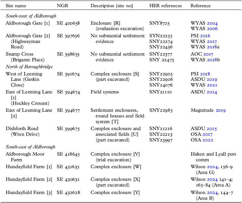
Important new evidence about the landscape in this area is provided by both recent developer-funded work and two independent research projects. As a result, fluxgate gradiometry has been deployed to map large areas in three broad zones. These are located immediately to the west of the Roman town, to the north of Boroughbridge on the opposite bank of the River Ure and about 3km to the south of our survey. These areas are discussed in turn below. As access to information about the results of these surveys has been variable, and analysis of evidence for some is still in progress, in the case of the developer-funded work, we have based our discussion on material deposited in the North Yorkshire Historic Environment Record (HER) and have not generally had access to the geophysical survey data itself. Hence, we provide only a high-level summary and simply map the extent of the surveys, allowing comparison with the results of our own work and forming a basis for the wider discussion that follows. The surveys discussed are summarised in table 1 with locations shown in fig 2.
Summary of sites found in developer-funded and other research projects.

South-west of Aldborough
In the area to the south-west of our surveys (fig 10), the land slopes gently to the north-west, with the lower ground towards the old A1 road now developed for housing. Here, three blocks have been surveyed, two of which are now built over. Adjacent to our Area 5 and our earlier survey of the suburbs of the Roman town,Footnote 66 work at Aldborough Gate [1] in 2004–5Footnote 67 provides further information that directly complements our surveys (fig 9). It revealed one corner of a settlement enclosure [site R] (with posthole structures within), defined by double ditches, which are dated by pottery to the third–fourth century ad.Footnote 68 The south-west side of this enclosure continues the line of our Ditch 13.3.Footnote 69
Map showing the extent of developer-funded geophysical surveys to the south-west of Aldborough. For location, see fig 2. Image: Vicki Herring.

Further to the west, more extensive gradiometry surveys and evaluation excavations were undertaken on lower lying, poorly drained land at both Aldborough Gate [2] and Stump Cross, but neither produced any evidence of Iron Age or Romano-British settlement sites. The Stump Cross evaluation did record a single Roman-period ditch as well as a scatter of pottery and ceramic building material.Footnote 70 The absence of settlement sites and field systems in this area seems real and perhaps indicates that this damp ground was used as open pasture.
North of Boroughbridge
To the north of the River Ure, four contiguous areas of survey in advance of planned housing development provide important new information about the landscape (fig 11). This area occupies a gentle south-facing slope that continues down to the bank of the river, which flows west–east in this stretch. The settlement of Langthorpe lies beside the Ure to the south-west of the new development, with the hamlet of Milby c 0.5km to its east, set back further from the river. At one limit of development, towards Langthorpe, to the west of Leeming Lane, an enclosure complex [site S] has been excavated following its discovery through survey and initial evaluation.Footnote 71 At the eastern extreme, off Dishforth Road, a similarly discovered enclosure complex [site U] has been partially explored in evaluation excavations.Footnote 72 Between these, an extensive system of rectilinear fields has been mapped in two adjacent surveys to the east of Leeming Lane,Footnote 73 with a linear complex running east–west and associated round houses mapped in the more northerly survey [site T].
Map showing the extent of developer-funded geophysical surveys to the north of Boroughbridge with a simplified plan of the Iron Age–Roman-period features revealed. For location, see fig 2. Image: Vicki Herring.

Enclosure complex [site S] is defined to the east by a north–south trackway with small enclosures flanking it, and a further track heading west through between enclosures. It appears from the low density of finds that the excavated area lies at the margin of a domestic settlement, the core of which is presumed to lie to the west or south. The ceramic evidence together with two radiocarbon dates indicate occupation in the late first century bc–mid-second century ad. Environmental sampling suggests that some agricultural activity took place, with arable crop processing and perhaps sheep rearing. The absence of any later pottery indicates abandonment early in the Roman period. Two ditchesFootnote 74 adjoining the eastern side of the main north–south trackway and integral with it, seem to form part of the field system that covers the area immediately to the east.
Further to the east, the other settlement investigated by excavation [site U] comprised parts of two adjacent enclosures, the more northerly of which revealed a sequence of round houses. Ceramics and radiocarbon dates show that occupation ran from the second/first century bc down to the second century ad, with evidence confirming domestic occupation. Environmental sampling provided limited information on crop husbandry and processing, with animal bones representing the disposal of domestic refuse. These enclosures continue to the east and, although they are not stratigraphically linked to the field system revealed by gradiometry in the same field, they appear to be broadly contemporaneous.
Between these two settlements, a large area to the east of Leeming Lane has been surveyed by gradiometry, but without excavation. There is very clear evidence for a field system, which was dated to the medieval period in the report on the more southerly area.Footnote 75 This conclusion was based on the suggestion that the boundaries post-date the ridge-and-furrow cultivation, yet are absent from the first edition Ordnance Survey map. A re-examination of the survey results, however, does not support the conclusion that the boundaries are later than the ridge-and-furrow cultivation, whilst truncation of the fields at the west by Leeming Lane – the medieval route of the Great North Road approaching the medieval bridge over the Ure – must imply an earlier date. This revised interpretation is supported by the apparent contemporaneity of two boundaries with the late Iron Age settlement to the west of Leeming Lane,Footnote 76 in addition to the more recent survey evidence from the area immediately to the north. Here, the field system is clearly integral with a series of smaller enclosures and round houses [site T] that are ranged east–west across the slope, forming a loosely linear arrangement similar to that seen in other parts of northern England.Footnote 77 On this basis, it seems most likely that these fields form part of the late Iron Age landscape, integral with the settlement enclosures [S and U] discussed above. The size and layout of the fields are comparable to other examples of the period, sometimes referred to as ‘Celtic’ field systems.Footnote 78 There are local parallels for similar fields a little further south,Footnote 79 but elsewhere in the vale they are scarce.Footnote 80 Two further observations can be made about these fields. First, they occupy good agricultural land on a south-facing slope and, second, they are quite close to the riverside. There may have been further settlements along the riverbank, as, in two places, the surveys have revealed what may be the backs of such enclosures.
South-east of Aldborough
Two research projects have recently provided new evidence for the Iron Age and Roman-period landscape to the south of Aldborough (fig 12), examining land on the slopes overlooking the river floodplain, close to the line of the Roman road that led south to York. In both areas gradiometry survey has been combined with limited excavation.
Map showing the extent of geophysical surveys at Aldborough Moor and Hundayfield Farm to the south-east of Aldborough showing the location of Iron Age–Roman-period settlement sites revealed in relation to earlier finds. For location, see fig 2. Image: Vicki Herring.

At Aldborough Moor Farm, c 2km south of the Roman town, survey of the course of the Roman road also revealed evidence of an enclosure complex that occupies a gentle north-east facing slope.Footnote 81 The settlement comprises a linear array of rectilinear enclosures on a north-west–south-east axis with associated trackways on the same alignment and evidence for connected field systems. The enclosure covered by the survey extends for c 175m and continues to the north-west. The pottery from the trial excavation on the enclosure dates from the late second to late fourth century ad.
At Hundayfield Farm, c 1.5km further south, a survey covering 73ha along with trial excavation was undertaken as part of Nick Wilson’s York University PhD research.Footnote 82 The area surveyed is on the higher ground overlooking the river and is characterised by an undulating landscape on sands and gravels that overlie the sandstone bedrock. The survey revealed a complex series of enclosures and associated field systems, with three main clusters of enclosures [sites W, X and Y] connected by trackways. One of these [site X] has been partially excavated, revealing a long sequence of settlement, with pottery evidence suggesting that it was occupied from the late Iron Age through to the late fourth century ad. These settlements lie close to two known burial monuments (below, DISCUSSION AND CONCLUSIONS) as well as the findspot of an inscribed milestone dated to the reign of Trajan Decius (ad 249–51) at Duel Cross.Footnote 83
DISCUSSION AND CONCLUSIONS
Survey evidence has fundamentally altered our understanding of late Iron Age and Roman-period settlement in this area, clearly demonstrating that the landscape was densely occupied with farms, a conclusion that is consistent with the pollen evidence,Footnote 84 although the overall density of settlement does vary. In our own survey, six possible farmstead sites were identified in an area of 179ha, c 3.35 sites per km2 (although this includes a large area of land on the flood plain). The other surveys recorded eight such settlements over 136ha, c 5.8 sites per km2, giving an overall value of 4.4 sites per km2. This indicates an exceptionally high density of settlement,Footnote 85 completely overturning previous understandings of the region.
These estimates, however, assume contemporaneity of occupation, which cannot be proven. Of the sites identified, five out of the eight from other projects have been dated by excavation, which contrasts with those from our survey where there has been no excavation, but for which we have surface survey evidence for three, meaning that some dating evidence exists for just over half the sites. Whilst both the forms of settlement and the available dating evidence support the idea that most are late Iron Age–Roman in date, there remains some uncertainty. However, if it were only half that estimated above, this would still represent a density comparable with other parts of Britain.Footnote 86 There is also some evidence that Roman annexation of the region had a differential impact, since the two excavated sites on the north bank of the Ure both seem to have been abandoned in the second century ad. This contrasts with the other dated sites, which show evidence for continuity of activity.
The surveys have also provided substantial new information about the nature of rural settlement in the vicinity of the Roman town, both in terms of types of settlement site and possible land use. The first point to note is the absence of evidence for villas in the area. In one sense this appears unsurprising as such sites are generally scarce in the region, with those noted mostly in the area to the east on and around the Wolds, although some others lie close to the line of the Roman road to the north of Aldborough.Footnote 87 This does, however, contrast with the observed trend for villas in Britain to be closely associated with those towns, like Aldborough, that had significant administrative functions. This is probably because those holding office as civitas magistrates had to fulfil a property qualification and so commonly held rural estates close to the towns where they served.Footnote 88 The only possible evidence for the presence of such elites outside Isurium itself (where there are substantial town houses) comes from the burials at Duel Cross close to Hundayfield Farm, c 3.5km to the south-east (fig 12). Here a tumulus, c 37m in diameter and c 5.4m tall, immediately to the west of the Roman road, was examined in the late eighteenth century, producing coins of the late first–early second century ad.Footnote 89 The mound is reported to have been quarried away by the mid-nineteenth century.Footnote 90 Geophysical survey has failed to provide any surviving evidence for the tumulus, probably because of a combination of the quarrying and its burial by an accumulation of soil resulting from downslope erosion.Footnote 91 Wilson assumes that the barrow is of prehistoric date with secondary Roman-period burials (and he has also identified a surviving Anglo-Saxon burial urn, presumably from such a secondary burial).Footnote 92 However, there are good parallels for Roman-period burial mounds of comparable size: on average they are c 6m in height, with a diameter of 25m – the largest diameter of those at Bartlow in Cambridgeshire being 43m.Footnote 93 Given the location of this tumulus right beside the Roman road at Duel Cross, it seems most likely to be Roman in date. Such a major burial monument beside the road would have remained a key landmark, providing a context for the third-century milestone found about 150m down the road to the south.Footnote 94 Furthermore, a burial in a lead coffin, excavated c 100m to the south-east of the tumulus in 2007,Footnote 95 perhaps indicates the presence of a larger cemetery. This coffin was contained within a stone cist and held the remains of a man aged 30–45 years, with isotope analysis suggesting that he originated in the Mediterranean.Footnote 96 The grave is undated, but parallels in York indicate a date in the later third century. As the excavator of the cist notes, the most likely context for such a burial is close to a villa, and on this basis it seems very likely that one was situated nearby. Since much of the area to the east has been surveyed by Wilson (above, OTHER SURVEY EVIDENCE, South-east of Aldborough), it perhaps lies on the slope above to the west, incidentally in the vicinity of the middle Iron Age hilltop enclosure at Grafton (above, GEOGRAPHICAL SETTING).
Second, the nature of the settlements located suggests a mixed pattern linked to the varied ecology of the area. A string of four smaller, simple enclosed sites (B, D and F) all lie on the flat lands close to the River Ure – each occupying positions close to the present river or to a palaeochannel. Whether these were primary settlements or fulfilled specialist functions is uncertain. By contrast, two sets of larger, complex enclosure systems have been identified. One lies on the north side of the River Ure opposite Boroughbridge (S and U) and is integrated with a field system. The others (A, K, Q, V, W, X and Y) are situated on higher land on the slopes overlooking the river. The morphology of two (K and Q) suggests economies involving the control of livestock. This interpretation is supported by the likely area of open pasture to the west of the town (above, OTHER SURVEY EVIDENCE, South-west of Aldborough). Others of these complex enclosures are associated with patchworks of smaller fields, paddocks and integrated trackways, indicating a mixed farming regime. The size of all these complexes suggests occupation by extended family groups.
These conclusions and the chronology of the sites clearly needs further testing with future archaeological work, but, for the time being, we are justified in concluding that survey work has transformed our understanding of this landscape, showing that it was much more intensively exploited in the Iron Age and Roman periods than previously assumed. This provides a new picture of the context of the Roman town.
Our gradiometry survey has provided no evidence for any substantial late pre-Roman Iron Age nucleated settlement in the immediate vicinity of the town, although, given the distribution of smaller but complex enclosure systems and the terrain occupied by the southern part of Isurium, it would be unsurprising if there was a similar settlement somewhere underlying it. A question remains about the nature of middle Iron Age activity in the area, with the quarried-away hilltop site at Grafton remaining poorly understood, but potentially having been focal.Footnote 97 Whatever its function at that period, there is nothing to suggest that it continued as a major centre into the late Iron Age. The lack of evidence for any pre-Roman nucleation adds weight to the conclusion that the town was founded de novo early in the Roman period.
The river crossing just upstream of Boroughbridge seems to be long-established, as the row megaliths known as the Devil’s Arrows (probably dating to the late Neolithic or Early Bronze Age)Footnote 98 is aligned on it. It may also account for the location of the very large but undated enclosure identified in the LiDAR data just to the north of the river.Footnote 99 This crossing, where the north–south route along the western edge of the vale intersects with that leading up into Wensleydale and the heart of the Pennines, seems to have determined the location of the invasion-period Roman fort to the south of the river at Roecliffe (fig 2).Footnote 100 Now that we have evidence of a densely occupied landscape at this period, it seems likely that this fort was located to oversee a large but dispersed population, a situation analogous to that of the contemporaneous fort at Hayton.Footnote 101 In the absence of evidence for Iron Age centralisation in this area, we would suggest that the dispersed pattern of settlement now revealed might imply that society in this area was heterarchical. This contrasts with the evidence further north from the Tees valley, where the major nucleus at Stanwick (and the textual sources) indicate that society was hierarchical. Such a distinction would support the suggestion that the Brigantes comprised an alliance of various septs or clans who had may have had varied social structures. The existence of a large resident population in this part of the Ure valley does, however, provide a context for understanding the focus of Roman power at this point and hence a context for the subsequent development of the Roman civitas centre here. Such a hypothesis needs further testing, but contributes to the debates about the origin of Roman urban and administrative systems in areas with heterarchical rather than hierarchical Iron Age societies.Footnote 102
ACKNOWLEDGEMENTS
We are extremely grateful to the Society of Antiquaries of London for a grant from the Jones Fund that supported this work. James Lyall kindly undertook some of the survey work for us in 2023. We would also like to thank the landowners and farmers who kindly gave us access to their land for survey: Andrew Lawson Tancred, Neil Bailes, Robert Bailes, Edward Craggs, Chris and Gillian Peacock and Tom Sanderson. Access to information about developer-funded work in the area was kindly provided by Peter Rowe (North Yorkshire County HER), Paul Johnson, FSA (Magnitude Surveys) and Peter Carne (Archaeological Services Durham University). Nick Wilson and Mike Haken very generously shared information about their research. The project received unstinting support and advice from Dominic Powlesland. Vicki Herring kindly helped with the illustrations.
ABBREVIATIONS AND BIBLIOGRAPHY
Abbreviations
- AGT
-
Archaeological Geophysics Toolbox
- ASDU
-
Archaeological Services Durham University
- HER
-
Historic Environment Record
- NGR
-
National Grid Reference
- NMP
-
National Mapping Programme
- OSA
-
On Site Archaeology Ltd
- PSI
-
Phase Site Investigations Ltd
- UTM
-
universal transverse mercator
- WYAS
-
West Yorkshire Archaeological Society


 Open access