Historical evidence
The presence of Hedones in the plain of Philippi is well document by Greek authors, including Herodotus, The Histories, VII.110, 114; Thucydides, History of the Peloponnesian War ड.58.2; II 99.4: “(…) the district of Mygdonia, between the Axius and the Strymon, being also added by the expulsion of the Edonians (…)”; IV.109; Strabo, VII.12: “As for the Thracians, the Pieres inhabited Pieria and the region about Olympus; the Paeones, the region on both sides of the Axius River, which on that account is called Amphaxitis; the Edoni and Bisaltae, the rest of the country as far as the Strymon”; Pausanias, Description of Greece, X.39.2; and Theocritus, Thalysia. Textual discordances as to their exact location are partly justified by the nomadic character of the Thracian tribes.
The rock art sites
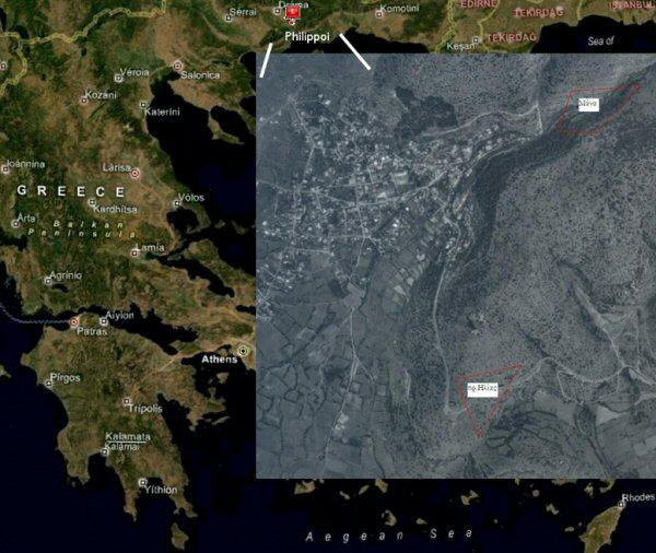
Rock art sites of Prophet Elias (πρ. ङλίαॢ Φ/ B.1-1α, 1β, B.2, B.3-Eiv) and Mana (तάνα Φ/B.1, B.2, B.3, B.4-Eiv) are located in the Municipality of Philippi , within the parish of Filippoi in Kavala Province (Figure 1). The GPS coordinates are: Prophet Elias (πρ.ङλίαॢ Φ/B.2): 41° 01'676'' N / 24° 01'822'' E / elevation: 189 +/- 7m. and Mana (तάνα Φ/B.1): 41°01'794'' N / 24°20'999'' E / elevation: 238 +/- 5m.
Satellite photograph of Greece. Inset: Philippi, aerial photograph. Red polygonal areas indicate respectively rock art sites: Prophet Elias (πρ. Ηλίας) and Mana (Μάνα). Satellite photograph: © NASA; inset: © Military Mapping Service, Greece.

Rock art has been produced by several ancient peoples all over the world and is frequent in Europe. However, in Greece, one of the places most studied by archaeologists, rock art has been ignored until recently. We report here about a project to study the rock engravings in the region of Philippi, which were probably carved by the Hedones (Edonians, Lat. Edoni), a Thracian tribe that occupied the lands stretching between the Strymon and Nestos rivers, and from Mt. Pangaion to the Rodopi mountain chain. Some engravings around the historic town of Philippi have already been reported, but no systematic study has so far been attempted, and the interest generally decreases with the distance from Philippi . Here are presented the engravings found just 2km from Philippi; some of them pre-date the Greek and Roman period. These engravings are of fundamental importance in terms of understanding the religious exchanges and influences between the Thracian populations and the urbanised settlers: they preserve evidence of the Thracian cultural substratum before and during the urban development of Philippi, and possible evidence of Greek, Roman and Byzantine influences on the rural populations.
Most of the archaeological evidence analysed so far refers to the transitional period between the Late Bronze and Early Iron Ages, when Thracian religious elements were being formed. Following an initial research (DRP) undertaken by George Dimitriadis (1998–2000), and financed by the Municipality of Philippi, a joint project of cooperation between HERAC-IISL-ALA was initiated in 2004 and the ‘Hellenic Rock Art Documentation Project’ (HRAD) began a full investigation of the rock art in the area of Philippi. The project has been approved by the Greek Ministry of Culture and is financed by the ‘Culture Enterprise’ office of the Municipality of Philippi and the Ministry of Macedonia/Thrace.
Context
Geomorphological Analysis
The area being investigated is located in eastern Macedonia . The geological substratum is composed of granite, syenite, diorite and marble. During the Holocene the Plain of Drama, or Plain of Philippi, was characterised by marshes and alluvial depositions. Since the seventh millennium BC, the climate in the region has remained stable, and pollen and pedological analyses prove that the area was covered by woodland (Davidson & Thomas 1986).
The HRAD research area is delimited by Mt. Phalakro (2111m) and Mt. Orvilos (1888m) to the north, Mt. Pangaion (1965m) and the Philippi Marshes (now drained) to the south-west, and Mt. Symbolo (694m) to the south-east.
The archaeological context
The territory was inhabited at least since the Neolithic (Reference RenfrewRenfrew 1971; Reference TodorovaTodorova 1978; Koukouli-Chryssanthaki & Romiopoulou 1992; Reference TreuilTreuil 1992; Reference DemouleDemoule 1994; Reference KalogirouKalogirou 1994), as the settlement of Dikili Tash ( c. 5000–3000 BC) proves, and the area remained settled also during the Bronze (3000–1050 BC) and Early Iron Ages (1050–700 BC), but periodic cycles of desertion and re-population have been recognised (Reference PapadopoulosPapadopoulos 2002).
Methodology of Documentation
Phase I (DRP)
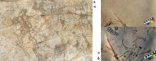
The fieldwork was undertaken over three years, focussing on the areas of Prophet Elias and Mana. A survey of the area was carried out to record essential environmental data and signs of ancient anthropic activity. Gallery mines, for the extraction of iron mineral, were in use until the eighteenth century, and were probably already in use in antiquity. Surface cleaning was conducted using the ‘neutral method’ (Reference AnatiAnati 1977) and the state of conservation of the engraved rocks determined. The engravings have been recorded by frottage technique (the pronounced roughness of the surfaces has caused unsatisfactory results) and tracing on PVC standard sheets (90 x 1.20cm). The engraving techniques are recognised as ‘hard pecking’ at Prophet Elias (Figure 2a) and ‘filiforme’ at Mana (Figure 2b).
a. ‘hard pecking’ engraving, πρ. Ηλίας Φ/ B .3 -Eiv, composed by horseman, weapon and other motifs. Figure 2b.‘filiforme’ engraving, Μάνα Φ, composed by horse rider, geometrical motives and anthropomorphic 'key' figure. Bottom: tracing of the same scene. © HERAC & G. Dimitriadis.

Three rocks were analysed:
-
• πρ. Ηλίας Φ/B.1 (1.85 x 1.75m in an excavated area of 6.10 x 5.20m). It is an emerging cliff in good state of conservation.
-
• πρ. Ηλίας Φ/ B .2 (13.50 x 6.50 m ). It is a flat slab in a good state of conservation. About 500m. from both rocks there is a water stream. Nearby there are two disused iron mines.
-
• πρ. Ηλίας Φ/ B .3 (7.70 x 5.00 m ). The rock is in fair state of conservation. At its base was found a small flake of the same rock now conserved within the archives of the Philippi Cultural Association.
Statistical analysis
Over 300 unique motifs have been recognised in the rocks of the Prophet Elias area. Initial calculations indicate that schematic figures and animals are commoner than Horsemen, which account for just 11 per cent (Table 1).

Phase II (HRAD)
In the second phase, the hypothesis proposed by Reference DimitriadisDimitriadis (1999) concerning the possibility that the Prophet Elias area was an open-air sanctuary of the Hedones has been tested. Exposing more of the known engraved rocks and completing the tracing of all the carved rocks on sheets has revealed more carvings.
New Discoveries
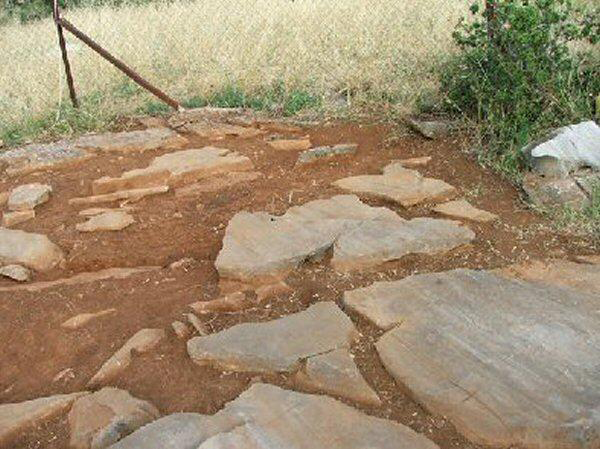
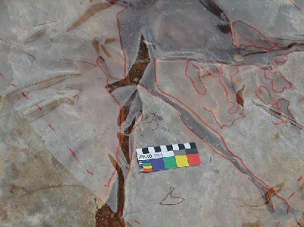
Prophet Elias area: During the thorough cleaning and stratigraphic exploration of area B1, a pit-hole full of darkish terrain was excavated. In the laboratory Carmelo Prestipino has determined the presence of charcoal in the terrain (Figure 3). Fragments of dark and red coarse ceramic vessels have been dated to the Late Bronze Age after optical examination by Andrea Vianello. These conclusions agree with the evaluation of the rock art style examined by George Dimitriadis. Preparation of photographs and drawings, as well as the cataloguing of potsherds, are being carried out by Ida Mailland and Andrea Vianello. Fernando Coimbra (in press) has discovered a new carving, labelled the Philippi Horse (Figure 4). It is a small horse, in naturalistic style, found during the opening of a new sector of rock at πρ. ङλίαॢ Φ/B.2, and studied by George Dimitriadis. The mounted figures are also being studied by George Iliades (HERAC).
πρ.Ηλίας Φ/ B.1-Eiv , Philippi. A pit hole containing dark ground is partly visible. © HERAC & G. Dimitriadis.

πρ.Ηλίας Φ/ B.2-Eiv, Philippi. Tracing of Philippi 'Horse', discovered by Dr Fernando Coimbra. © HERAC & G. Dimitriadis.

After considering the archaeo-astronomical annotations written by Adriano Gaspani (Astronomical Observatory of Brera-Milan), the authors believe that the carvings, the pit-hole, and the engraved horseman figure on rock B.1 may be linked. The shadow of a wooden pole, introduced into the pit hole, was projected onto the horseman during the summer solstice on Friday, 21 June 2006 .
Mana area: three new rocks (तάνα Φ/B.2, B.3, B.4-Eiv; Figure 2b) have been discovered after Mr Stelios Foustopoulos recognised engravings on a rock. Mana is located in a strategic position along old mountain passages that connect the small valley of Mesorema to the Plain of Philippi. The geomorphology of rock तάνα Φ/B.1 is under study by Daniela Cardoso (Museum Martins Sarmento-Portugal) so as to establish the future conservation work required. The तάνα Φ/B.1 panel contains quartzite inclusions, with clear signs of its removal around them. Rocks तάνα Φ/B.2, B.3 and B.4 have only been partly unearthed and sheet-tracing is therefore still on-going. The geomorphology of the rocky surfaces is quite different from the Prophet Elias area, and composed of grey marble and gneiss inclusions.
Photogrammetric survey of rock surfaces
During the 2006 fieldwork season, Andrea Vianello and Davide Delfino (IISL) attempted a photogrammetric and GIS survey of the rocks. GIS software packages were also used. A fixed frame (0.60 x 0.80m) was used as reference as it proved impossible to use specialist equipment because of the uneven nature of the terrain. Particular care was taken to maintain the carvings under adequate natural light; the photographs were therefore taken in batches over a period of seven days. The resulting photographs will require substantial post-processing, and are intended to become in their own right a research tool and aids to experimentation and further study of the carvings in their original context.
Brief Discussion/Conclusions
The investigation and study of the Late Bronze and Early Iron Age engravings are particularly important because of a significant lack of information from written sources. The study of nomadic tribes, such as the Hedones, is largely based on fieldwork – as that undertaken as part of the present project. In particular, the research project is advancing our knowledge of their religion and mythology, as well as of their economic and cultural development.
Our preliminary conclusions suggest that the area was used for open-air ritual activities, and that the horse and horsemen were the subjects most likely to have been celebrated. Preliminary interpretation of the rock art suggests that the symbols of the horse and the human were initially separate, although associated, and merged as a single symbol in later phases. The symbol representing horsemen remained in use and became a marker of the local cultural identity; in the Greek, and then Roman, town of Philippi numerous reliefs represent horsemen in ritual contexts, including ‘hero cults’ (Collart & Ducrey 1975; Reference AbrahamsenAbrahamsen 1988). Thus, understanding the origins and significance of this symbol will be important, not only to help ‘decipher’ rock art, but also for our comprehension of later periods.