

INTRODUCTION
In 2011, A Martindale, K Ames, K Supernant, and K Edinborough initiated an archaeological project in Prince Rupert Harbour (PRH) (Figure 1) on the northern British Columbia coast. PRH has an extraordinarily rich archaeological record relevant to Northern Tsimshian history and to a range of questions about Northwest Coast and hunter-gatherer-fisher social and economic evolution. In an area of approximately 180 km2, the Harbour contains 157 currently recorded shell middens, of which 66 are classified as villages (Ames and Martindale Reference Ames and Martindale2014) (Figure 1). Consequently, the Harbour has seen archaeological research spanning the last century. The various goals of the current project, jointly funded by the Social Science and Humanities Research Council of Canada (SSHRC) and the National Science Foundation (NSF) of the United States, required refining the Harbour’s settlement pattern history for the last 6000 yr. Achieving this goal necessitated establishing initial and terminal dates for a representative sample of the Harbour’s village sites, and midden formation chronologies for a subset of middens. Accomplishing this demanded a large number of radiocarbon dates. We currently have 262 new dates from a range of contexts, including 38 village sites, 205 of which are from marine shell.
Map of Prince Rupert Harbour region

Despite its problems, using shell for building chronologies has advantages. In the coastal areas of British Columbia, Canada, and Alaska, USA, shell-bearing sites are ubiquitous and reflect both the byproduct of food consumption and engineering efforts to construct level, well-drained habitation terraces in a highly crenulated coastal landscape dominated by bedrock outcrops and wetlands. While dedicated construction episodes are known in which massive anthropogenic landforms are built in short periods of time (see Martindale et al. Reference Martindale, Letham, McLaren, Archer, Burchell and Schöne2009), shell-bearing sites also capture recurring daily behaviors such that their lower and upper surfaces approximate the beginning and ending of occupation. Regional settlement patterns can be captured by large samples of dated basal and terminal components using ubiquitous marine shell, which is increasingly accessible via percussion coring (Cannon Reference Cannon2000; Martindale et al. Reference Martindale, Letham, McLaren, Archer, Burchell and Schöne2009; Pluckhahn et al. Reference Pluckhahn, Thompson and Cherkinsky2015). Thus, a study of settlement patterns in this region and other coastal contexts is improved via the dating of marine shell. Our goal is to develop useful, accurate, and precise ages for marine-based archaeological samples, to be consistently calculated for a like-for-like comparison. Such a value is often perceived as less critical in some geological contexts, such as the construction of relative sea-level curves (Shugar et al. Reference Shugar, Walker, Lian, Eamer, Neudorf, McLaren and Fedje2014), where chronological precision of fewer samples from longer time periods is valued over the accuracy of many samples from shorter intervals. Despite a history of 14C-based research, calculation of securely calibrated calendar ages from marine shell samples remains a large problem for archaeologists working in Prince Rupert Harbour and elsewhere on the Pacific Northwest coast, with variable effects from very deep water reservoirs, and other localized confounding geological processes, such as carbonate leaching (Hutchinson Reference Hutchinson2014; Reimer Reference Reimer2014). Although a global average surface water marine reservoir effect offset of approximately 400 yr is well known, no consensus has been reached concerning the best way to approach this problem regionally or at the scale of the study area in Prince Rupert Harbour.
To highlight this issue and to suggest a way forward, we focus on one particularly important site in Prince Rupert Harbour (Figure 2), Kitandach (GbTo-34), using what we consider to be the most robust methodology for ΔR calculation, as developed by the Scottish Universities Environmental Research Centre (SUERC) in Russell et al. (Reference Russell, Cook, Ascough, Scott and Dugmore2011) and Cook et al. (Reference Cook, Ascough, Bonsall, Hamilton, Russell, Sayle, Scott and Bownes2015). In a seminal paper, Stuiver et al. (Reference Stuiver, Pearson and Braziunas1986) defined the marine reservoir age as R(t), the difference in conventional (uncalibrated) 14C age between synchronous samples from atmospheric and marine environments. They derived a marine calibration curve to model this offset, using the atmospheric ∆14C data and incorporating time-dependent variability in R(t) (Stuiver et al. Reference Stuiver, Pearson and Braziunas1986). This curve has been repeatedly updated and now accounts for the last 50,000 calibrated years BP (Marine13; Reimer et al. Reference Reimer, Bard, Bayliss, Beck, Blackwell, Bronk Ramsey, Buck, Cheng, Edwards, Friedrich, Grootes, Guilderson, Haflidason, Hajdas, Hatté, Heaton, Hoffmann, Hogg, Hughen, Kaiser, Kromer, Manning, Niu, Reimer, Richards, Scott, Southon, Staff, Turney and van der Plicht2013). In addition to a temporally variable R(t), there are regional deviations from the contemporaneous global average R(t) value, which are a variable function of climate and oceanic circulation systems; these are expressed as ∆R values to be used in conjunction with the Marine13 curve. Derivation of a ∆R value for a specific region and time period can be calculated by a number of methods, but here we focus on one we consider to be particularly accurate. This method uses all statistical information contained within contemporaneous multiple paired marine and terrestrial samples obtained from discrete contexts formed over short time periods (Ascough et al. Reference Ascough, Cook, Dugmore, Barber, Higney and Scott2004, Reference Ascough, Cook and Dugmore2005). Following the latest SUERC research (Cook et al. Reference Cook, Ascough, Bonsall, Hamilton, Russell, Sayle, Scott and Bownes2015), the great advantage of taking multiple paired samples from a linked series of archaeological contexts is that the archaeological contexts and samples therein are not assumed to be coherent or correct, as outlying samples can be determined statistically using a simple chi-squared (χ2) test of the marine and terrestrial data, before they are calibrated. The disadvantage of this approach is that even given ideal 14C samples, the spatial-temporal range of suitable archaeological sites may be limited. We see this as an empirical problem as neighboring sites can be later compared. Perhaps more confounding are natural events such as tsunamis (McMillan and Hutchinson Reference McMillan and Hutchinson2002), which may completely disturb the integrity of the deposits and yield nothing chronologically useful to measure. On the other hand, if deposits in a particularly coherent archaeological unit are disturbed, but there is no evidence of tsunami deposits, it is quite possible that interesting anthropogenic activity may be causal, so an imprecise set of results may be more useful than initially thought.
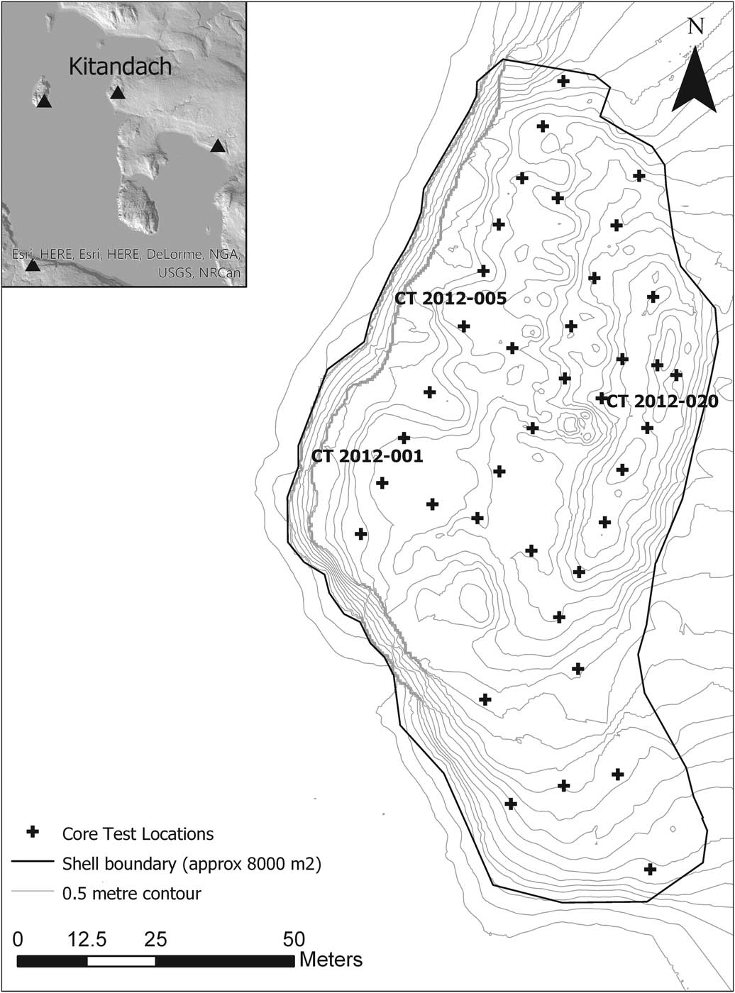
Map of the Kitandach (GbTo-34) site with the core test locations. Samples used in this study collected from labeled cores.
SAMPLE EXTRACTION AND SELECTION
Kitandach is a large shell-bearing site located in the Venn Pass/Metlakatla Pass area of PRH, spanning the period from about 5500 yr ago to the 19th century (Figure 2). The upper component of the site is consistent with a major Tsimshian village with at least 17 visible structural depressions. It is unclear how deep the stratigraphy of the latest village form extends, but it is likely that the subsurface contains earlier villages, likely with different house and perhaps village forms, and possibly earlier non-village components such as shell terraces for camping and resource collection (see Martindale et al. Reference Martindale, Letham, McLaren, Archer, Burchell and Schöne2009 for an example). Percussion coring was developed for the investigation of large shell-bearing sites (Cannon Reference Cannon2000; Martindale et al. Reference Martindale, Letham, McLaren, Archer, Burchell and Schöne2009). The technique is simple in principle: a hollow 92.5-cm (3-ft) long bit, 2.5 cm in diameter, containing a plastic liner, is hammered into the ground to retrieve samples of the subsurface. Extensions to the bit apparatus allow coring in 92.5-cm increments to depths of over 10 m. Each core is composed of a series of tubes representing the collection of subsurface material from the ground to below sterile geological parent material. Cultural components are highly visible (usually containing shell or charcoal), though compressed. Charcoal and shell can both present “old” problems that disassociate time of death from anthropogenic use. Unfortunately, the charcoal we could retrieve did not readily facilitate taxa identification. We mitigated this in Kitandach through sample selection of ubiquitous microscopic charcoal fragments and the selection of Mytilus sp. (likely Mytilus trossulus) for dating. Ubiquitous charcoal is more likely to derive from routine hearth use and thus is more likely to reflect regular harvesting of firewood. Mytilus sp. grows in rocky conditions and is harvested for consumption at maturity (4–5 yr) and brought to residential sites. Finally, we identified and removed potential “old” samples using a χ2 test after 14C analysis (cf. Burley et al. Reference Burley, Edinborough, Weisler and Zhao2015).
Within large village sites, multiple separate components are common, separated by potential paleosols of varying thicknesses, all of which are distinct from the basal geological parent material. At Kitandach (GbTo-34), we took 40 core tests at approximately 20-m intervals across the site (Figure 2). We selected four samples each of charcoal and marine shell from three stratigraphic components (basal, terminal, and a mid-component transition) for MRE estimation.
SAMPLE PRETREATMENT AND PROCESSING
All methods including sample pretreatment, CO2 generation and purification, graphitization, and accelerator mass spectrometry (AMS) measurement were as described in Dunbar et al. (Reference Dunbar, Cook, Naysmith, Tripney and Xu2016).
∆R Calculation
To calculate an accurate ∆R value for Kitandach, we followed the SUERC methodology (Ascough et al. Reference Ascough, Cook and Dugmore2005; Russell et al. Reference Russell, Cook, Ascough, Scott and Dugmore2011; Cook et al. Reference Cook, Ascough, Bonsall, Hamilton, Russell, Sayle, Scott and Bownes2015), and employed a multiple paired sample approach to ensure contemporaneity between groups of marine and terrestrial materials by statistically assessing for outliers using the χ2 test. We sampled the shell midden extensively and obtained 24 shell/charcoal pairs, with four pairs of samples from each of three, separate, stratigraphic components within the shell midden (see Table 1).
The samples, archaeological contexts, and 14C data discussed in the text.

RESULTS
Following the ∆R calculation method of Cook et al. (Reference Cook, Ascough, Bonsall, Hamilton, Russell, Sayle, Scott and Bownes2015), we performed χ2 tests on the samples to determine outliers and therefore potentially problematic contexts. Using samples that passed the test, we then calculated ΔR and error values for every possible terrestrial/marine pair for each viable context. From this, a weighted mean ΔR value was calculated for each context. The potential variability in the ΔR value was calculated as the standard error for predicted values. This equates to the square root of the sum of the squares on the standard deviation of the weighted mean ΔR value and the standard error. Only context 005 passed the χ2 test immediately (Table 1). This provided a ΔR value of 267±45. The four charcoal age measurements were combined to provide a weighted mean 14C age for this context of 4197±14 14C yr BP, which calibrates to 2885 to 2705 cal BC (95.4% probability). Context 001 returned results that were too variable to be of use. When one outlier sample was removed from each of the marine and terrestrial groups from context 020 (SUERC-44479 and SUERC-44480) (Table 1), the remaining shell samples passed the outlier test while the charcoal samples only marginally failed the test. We performed the ΔR calculations on the remaining samples. The ∆R based on three remaining marine and terrestrial pairs was 288±69. The weighted mean terrestrial age was 1675±30 14C yr BP, which calibrates to a calendar age range for this context of AD 265 to 425 (95.4% probability).
DISCUSSION AND CONCLUSIONS
We have derived two useful ∆R values for Kitandach, 267±45 14C yr for the period 2885–2705 BC and 288±69 for the period AD 265–425. In addition, using the 14CHRONO Marine Reservoir Database, held by Queen’s University, Belfast, we derived a third, average value based on five values from the immediate area of Prince Rupert Harbour, derived by McNeely et al. (Reference McNeely, Dyke and Southon2006). These five values gave a weighted mean of 265±88 for 19th century data, where the error calculation is the standard error for predicted values, for consistency with our own data. Taken together, these data begin to suggest the possibility that the MRE for the Prince Rupert Harbour area has been relatively constant over approximately the past 5000 yr. This is entirely in line with the conclusions of Southon and Fedje (Reference Southon and Fedje2003) for the wider British Columbia coast. They dated wood/shell pairs from natural beach deposits and archaeological midden sites and developed a record of reservoir ages extending back to ~11,000 BC. Other regional studies have also yielded similar values (Hutchinson Reference Hutchinson2014), but have not taken the multiple paired sample approach developed by SUERC, which leaves them more prone to inadvertent statistical error. On the other hand, ideal multiple paired samples from clearly identifiable contexts can be very difficult to find in these crucial midden contexts without the appropriate methodologies, so researchers have understandably calculated a pragmatic ∆R value whenever possible. ∆R results from more pragmatic single-paired studies (e.g. Eldridge et al. 2014) may vary simply because their smaller samples sizes are measured over longer periods of time without a robust test for statistical outliers (see Cook et al. Reference Cook, Ascough, Bonsall, Hamilton, Russell, Sayle, Scott and Bownes2015).
We propose that more studies use the multiple paired sample approach as we quickly identified outliers and potentially problematic contexts. On the basis of our results, it would appear that a ∆R value of 273±38 (weighted mean of our two values) is a good estimate for this research area, a conclusion supported by the McNeely derived weighted mean value of 265±88. The mixed context of 001 is suggestive of particularly intriguing anthropogenic activity that will be explored elsewhere.
ACKNOWLEDGMENTS
We wish to thank the following people and organizations: Lax Kw’alaams Indian Band, Metlakatla Indian Band, Susan Marsden, David Archer, Bryn Letham, Iain McKechnie, Ian Hutchinson, Eric Guiry, Steven Dennis, David Leask, and Phillipa Ascough. Also, SUERC staff are thanked for the 14C sample preparations and measurements. 14C dates were obtained through (US) National Science Foundation Grant Number 216847 awarded to Kenneth Ames as Principal Investigator. Samples for dating were collected through the Social Sciences and Humanities Research Council of Canada Grant Number 410-2011-0814 awarded to Andrew Martindale as Principal Investigator.


 Open access