Introduction
Outbursts of glacier-dammed lakes are well-known phenomena of the glacier landscape. Due to the rapid drainage process during such outbursts and the damage to cultivated areas known from recent and former outbursts, they are of great importance to glaciological research. The magnitude and frequency, of outbursts of glacier-dammed lakes are in close correlation to the oscillations of the damming ice masses (e.g. Reference LiestølLiestøl, 1956).
The aim of this paper is to show the effects of the retreat of Gåsbreen, southwest Spitsbergen, Svalbard, on the periodic outbursts of Goësvatnet. The retreat of the glacier during the 20th century has changed the geometry of the damming ice masses as well as the geometry of the lake, the lake volume and the tunnel system used for the outbursts. Using an empirical formula, the effect of the changed lake volume on the peak discharge of outbursts will be investigated, whereas the effects of the changed ice-dam geometry, lake geometry and outlet tunnel system will be shown by means of a physically based model (Reference ClarkeClarke, 1982). The retreat of Gåsbreen and the evolution of Goësvatnet since 1899 are well documented by various aerial photos, maps and field observations. It is also the aim of this study to show that a qualitative and quantitative description of historical outbursts of glacier-dammed lakes can be given without discharge measurements but by using a physically based model and careful interpretation of old maps, aerial photos and field observations.
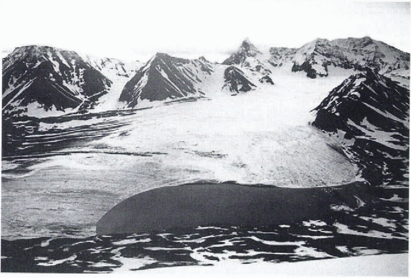
Goësvatnet is a marginal ice-dammed lake (Fig. 1), which in 1991 was 30 m deep and covered an area of about 0.5 km2. It is dammed by the active and stagnant ice of Gåsbreen, a temperate valley glacier (Fig. 1). A detailed description of the evolution of Gåsbreen and Goësvatnet since 1938 can be found in Reference SchönerSchöner and Schëner (1996). Outbursts of the lake have been presumed since 1938 (Reference PillewizerPillewizer, 1939) and have been known since 1956 (Reference Grzés and BanachGrzés and Banach, 1984). The first direct observation of a jökulhlaup of Goësvatnet was made by the authors of this study during an expedition in summer 1991.
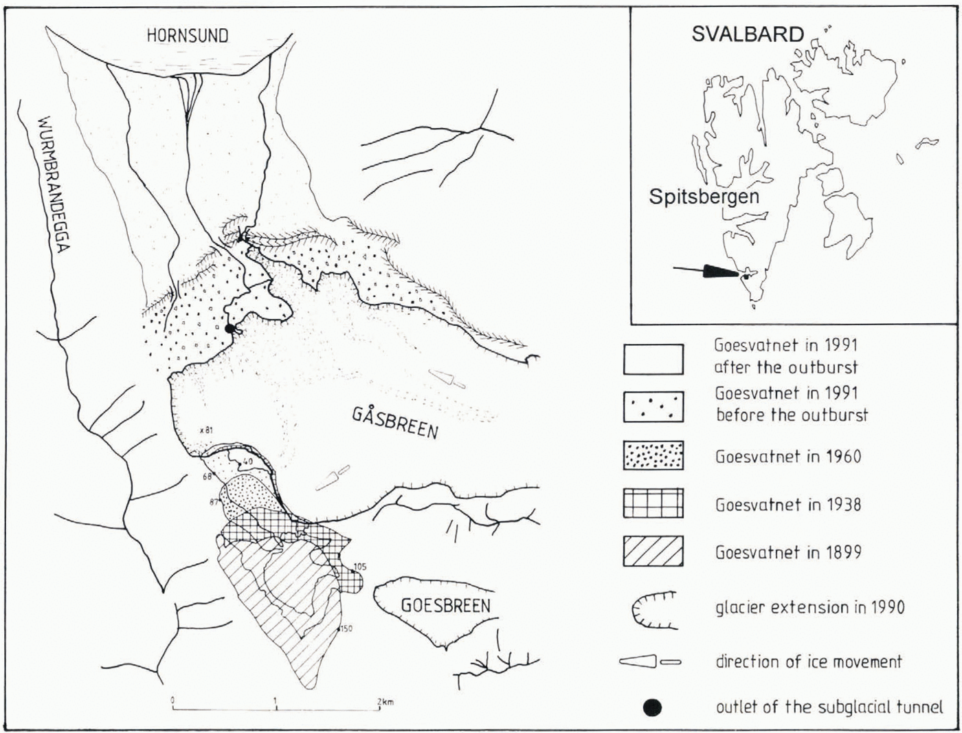
Map showing the location of Gåsbreen and the situation of the ice-dammed lake Goësuatnet in various years.

Evolution of Gåsbreen and Goësvatnet in the Period 1899-1991
The first evidence of the lake is in a map made by De Geer in 1899 (Reference De GeerDe Geer, 1925). At that time the lake was dammed by the ice masses of Goësbreen which formed a confluence with Gåsbreen in the area of the lake. Various maps (Reference De GeerDe Geer, 1925; Reference PillewizerPillewizer, 1939; Polska Akademia Nauk, 1987; Reference SchönerSchöner and Schöner, 1996) show that the ice dam was thinned by about 100 m between 1899 and 1990. Due to this fact and the lack of ice supply for the damming ice masses, the lake moved north and the maximum water level sank from about 150 to 68 m a.s.l. (Fig. 1).
The formation of these substantial damming iee masses in previous years can be explained by: (1) favourable climatic conditions in this period (Reference BrazdilBrazdil and others, 1988) permitting such an advanced state of the glacier: (2) a surge (or kinematic wave) of the glacier in an earlier time period (Reference BarauowskiBaranowski, 1977).
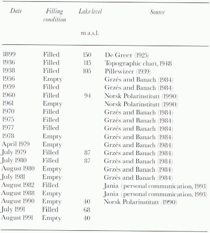
The evolution of Goësvatnet since 1899 documented by maps, aerial photos and field observations is compiled in Table 1. In most of the cases the field observations are, however, related only to the filling condition of the lake.
Information and observations about the condition of the ice-dammed lake Goësvatnet for the time period 1899-1991

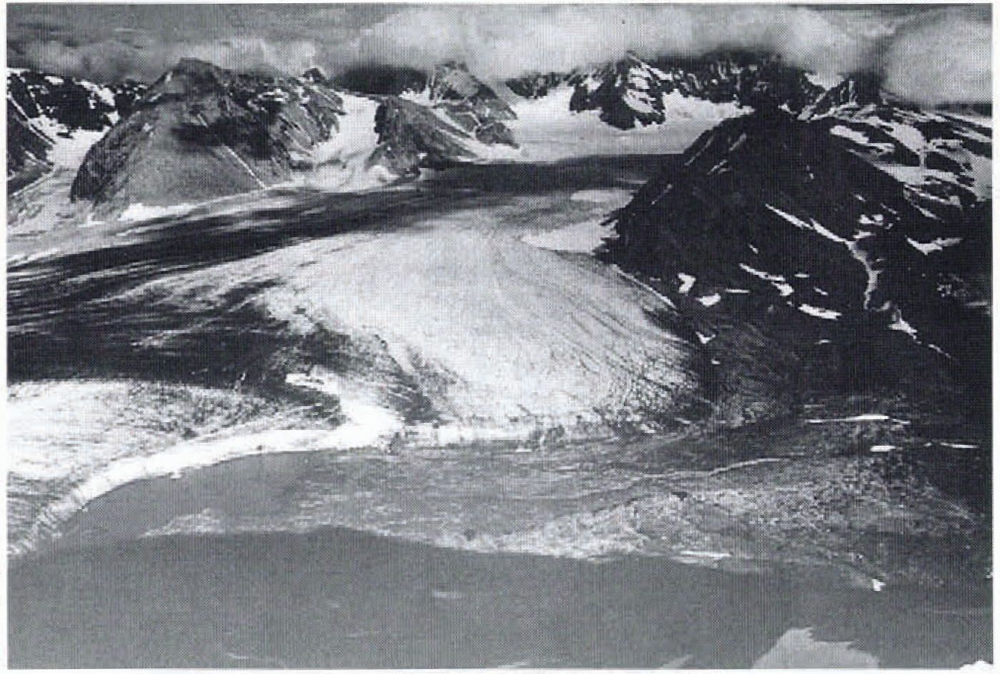
It can be seen from Table 1that on aerial photos laken in 1961 and 1990 the lake is visible in an empty state. Photo-grammetric interpretation of these aerial photos enables mapping of the bottom topography of the lake (Reference SchönerSchöner and Schöner, 1996). In a next step the volume of Goësvatnet can be computed for those years when the extension of the lake is shown on large-scale maps, namely, for 1938, 1961 and 1990.
For the purposes of investigating outburst floods of Goësvatnet, the maximum lake volume at the initial state of outbursts is of interest. For the outburst of Goësvatnet in 1991 the maximum lake level is known from direct observation, whereas the topography of the lake is taken from the 1990 map. An outburst in summer 1961 can be derived from an aerial photo taken in 1961 showing Goësvatnet in an empty state and the maximum extension of the lake in a very accurate way by the extension of mud. Based on this information the maximum lake volume in 1961 could be derived from the known lake topography and the extension of mud.
An outburst around 1938 is not known for certain, but it was presumed by Reference PillewizerPillewizer (1939). Indications for his assumption were field observations during an expedition in 1938. Due to flood events the sandur plain was free of vegetation, whereas terraces and moraines were vegetated. Moreover, the frontal moraines in the area of the damming ice masses of Gåsbreen showed a well-developed breach which was drained only by a very small river during the summer of 1938. The dimensions of the breach indicate, however, that is was sometimes drained by a much larger amount of water. Shorelines of Goësvatnet showed that the maximum lake level was not higher than about 130 m a.s.l. at this time (Reference PillewizerPillewizer, 1939). Using these observations, the map of 1938 (Pillewzer, 1939) and the lake topography derived from the map of 1990 an estimation of the maximum lake volume was possible.
There is no hint of outbursts of Goësvainet around 1899. Reference PillewizerPillewizer (1939)reports that the highest shoreline of Goësvatnet was found at 143 m a.s.l. which fits rather well with a lake level of 150 m a.s.l. shown in De Geer’s map in 1899 (Reference De GeerDe Geer, 1925). Furthermore, a great alluvial fan on the orographical lefthand side of the marginal zone in the area of the glacier’s frontal moraines can be seen from this map. This possibly indicates an episodic drainage of the lake through a channel in the marginal area of the damming ice masses of Gåsbreen for the period around 1899. Due to the lower accuracy of De Geer’s map the lake volume was not computed for 1899.
The computed lake volumes of Goësvatnet for individual years are shown in Table 2. The topography ofthe lake in 1938, 1961 and 1990 is shown in Figure 2and is also described in Table 2by means of a geometric function in the form of:

where h wtis lake elevation at time t, h 0is lake elevation at the start of the outburst, V tis lake volume at time t, V 0is lake volume at the start of the outburst, and Mis a geometric function.
Bottom topography of Goësvatnel in 1938, 1961 and 1991 derived interpretation of contour maps.
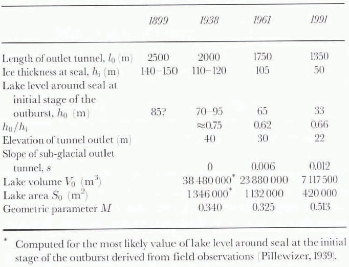
Topographic parameters derived from interpretation of aerial photos and maps for outbursts of Goësvatnet in various years. 1991 data are based on interpretation of aerial photos taken in 1990 and on field observations; 1961 data are based on interpretation of aerial photos taken in 1960 and 1961

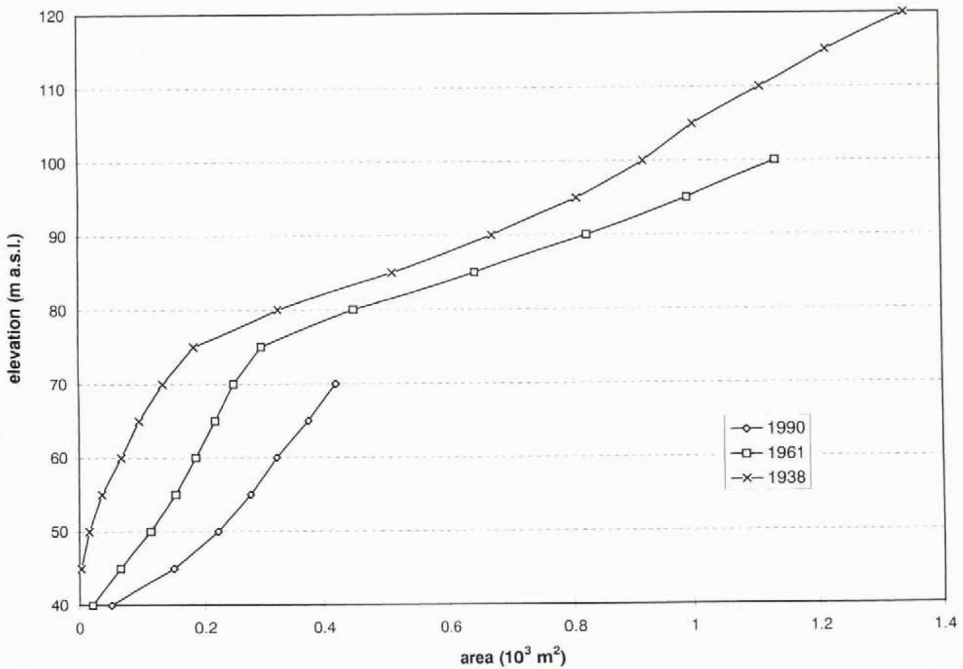
It can be seen from Table 2that Goësvatnet changed its geometry from a cone-shaped reservoir in 1938 and 1961 to a paraboloid-shaped reservoir in 1991. The agreement between the lake geometry computed by the geometric function and the geometry derived from a map is shown in Figure 3for 1938.
Lake volume of Goësvatnet in relation to the lake level in 1938 estimated by interpretation of a contour map and by means of a geometric function.
Table 2also includes values of ice thickness in the vicinity ofthe seal, and the lake level above the seal at the initial stage of outbursts. The relation between these two values is of interest in the investigation of the triggering mechanism of the outbursts. For 1938 the seal is assumed to be in the area of maximum ice thickness of the direct junction line between the moraine’s breach and the lake. The bottom topography of the glacier in 1938 is known from the map of 1990 showing this zone free of ice due to glacier retreat, whereas the glacier surface in 1938 is known from the 1938 map. For the outbursts in 1961 and 1991 the inlet and the outlet of the subglacial tunnel were bound to the border between the active and stagnant part of Gåsbreen marked by a medial moraine. The bottom topography of the glacier in 1961 and 1991 has been extrapolated from the region free of ice, and the glacier surfaces are known from the maps. So the seals in 1961 and 1991 were chosen in the area of maximum ice thickness of the medial moraine.
It can be seen from Table 2that the ratio of ice thickness to water height at the seal is much too high to make possible a flotation of the damming ice masses of Gåsbreen. This indicates another triggering mechanism for the outbursts of Goësvatnet. It is a well-known feature of jökulhlaups of marginal ice-dammed lakes that they start long before flotation is possible (e.g. Reference FisherFisher, 1973; Reference BjönssonBjörnsson. 1992).
The subglacial outlet tunnel used around 1938 and in 1961 and 1991 is characterised by the length and slope of the tunnel in Table 2. Due to the retreat of Gåsbreen the length of the tunnel was reduced by about 35% between 1938 and 1991. In the same period the slope of the outlet tunnel down-stream of the seal changed from about horizontal to 0.012 (Table 2).
It is also evident that the lowering of the ice dam has changed the local climatic conditions of the ice dam, as in general at lower altitudes the iee ablation will be increased. This leads to a feedback mechanism for the thinning of the damming ice masses.
Observed Outburst in 1991
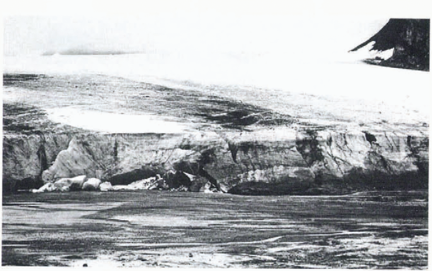
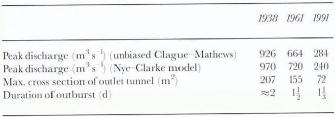
At the end of July 1990 the lake was nearly empty (aerial photo, 1990). Within 1 year the lake filled again and the water level rose to the height necessary for the beginning of an outburst (68 m a.s.l.) on 24 July 1991 (Fig. 4). Then the outburst started, and the lake lost 7117500 m3of water within 1.5 d. The lost lake volume was derived from an interpretation of the 1990 contour map. Goësvatnel lost its water through one tunnel between the active and the stagnant part of Gåsbreen (Fig. 5.). The inlet and the outlet of the tunnel were easy to identify during the fieldwork. The outburst of Goësvatnet led to an increased outflow of the main proglacial river but did not flood the sandur plain. Due to higher river discharge and sediment transport capacity, a large brown fan formed in the sea. After the outburst the situation was quite similar to the one in 1990 with a more or less empty lake (Fig. 6).
Goësvatnet before the outburst on 24 July 1991.
Outlet tunnel of the 1991 outburst of Goësvatnet at the border between the active and stagnant ice of Gåsbrren.

The outburst of Goësvatnet in 1991 started after a period of strong ablation due to high air temperature and intensive radiation. So in our opinion the initial stage of the outburst in 1991 was triggered by the pressure decrease during increased discharge in subglacial channels (Reference RöthlisbergerRöthlisberger, 1972) resulting from intensified ablation. Moreover, at the same time the amount of water stored in the lake was increased, causing higher water pressure in the vicinity of the seal.
Tools for Computation of Jökulhlaup Discharge
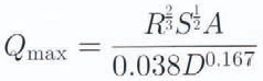
An effective tool for the estimation of peak discharge of jö is the empirical formula of Reference Clague and MathewsClague and Mathews (1973).
where Q maxis the maximum discharge in m3s−1and V 0is the initial volume ofthe lake in 106m3. This regression formula was reworked by several investigators, who included more data points for the relation. The form of the relation proposed by Reference Costa, Baker, Kochel and PattonCosta (1988)is
![]() (r 2= 80%; s.e = 0.42 log-log units).
(r 2= 80%; s.e = 0.42 log-log units).
Reference Desloges, Jones and RickerDesloges and others (1989)showed an unbiased form for this log-log relation:
In our investigation we excluded those data points of the relation where jökulhlaups were related to the “sudden break” of the ice dam, as suggested by Reference HaeberliHaeberli (1983). We also excluded data points of jökulhlaups which were not related to subglacial drainage. For this “progressive enlargement” relation which is also relevant for the outbursts of Goësvatnet we have found:
![]() (r 2= 93%: s.e. = 0.20 log-log units)
(r 2= 93%: s.e. = 0.20 log-log units)
and for the unbiased form:
(outburst discharge data extracted from Reference Clague and MathewsClague and Mathews (1973), Reference ClarkeClarke (1982), Reference HaeberliHaeberli (1983), Reference Costa, Baker, Kochel and PattonCosta (1988), Reference RussellRussell (1989)and Reference BjönssonBjörnsson (1992); number of cases = 17). This data set is more homogeneous and shows a higher coefficient of correlation between the lost lake volume and the peak discharge compared to the data set of Reference Costa, Baker, Kochel and PattonCosta (1988). One can see that the derived equation is very similar to the original Clague Mathews formula. Various field observations have shown that outburst floods of glacier-dammed lakes are very often related to progressive enlargement of subglaeial outlet tunnels. Due to this fact the similarity between our regression equation and the original Clague-Mathews formula explains why the unbiased formula has worked well in many cases.
An alternative method for estimating the peak discharge of the proglacial river is based on the continuity equation and the Manning-Stickler relation (slope-area method; Reference Desloges, Jones and RickerDesloges and others, 1989).
where Ris hydraulic radius (m), Sis bed slope for a 100 m channel reach, Ais cross-sectional area (m2), and Dis average intermediate axis (m) of the ten largest particles in the river-bed.
A third approach for discharge compulation of outburst floods is to use physically based models (e.g. Reference NyeNye, 1976; Reference Spring and HutterSpring and Hutter. 1981; Reference ClarkeClarke, 1982). Reference NyeNye (1976)and Reference ClarkeClarke (1982)developed a model based on tunnel geometry, continuity, energy conservation and beat transfer with:
where h iis ice thickness al the seal, z0is initial lake elevation above the tunnel outlet, L 0is drainage tunnel length, Q iis water inflow to the lake. n′ is Manning roughness coefficient. θ 1is lake water temperature, and V(h w) is lake volume distribution with depth.
Contrary to the empirical formula of Clague and Matthews the Nye-Clarke model enables the investigation of the effects of changed physical parameters like the lake geometry or a changed subglacial tunnel system on the discharge curve in addition to peak discharge compulations (Reference ClarkeClarke, 1982).
Effects of Glacier Retreat on Discharge During Outbursts of GoËsvatnet
Effects of glacier retreat on the outbursts of glaeier-dammed lakes have been discussed in the literature for a long time. Reference ThórarinssonThórarinsson (1939)described ice-dammed lakes of Iceland and their values as indicators of glacier oscillations in historical times. The effect of glacier oscillation on the stored lake volume and the magnitude of outbursts of a glacier-dammed lake was first discussed in detail for a Norwegian lake in a paper by Reference LiestølLiestøl (1956). Liestøl showed the evolution of an ice-dammed lake from the initial state of the lake to the first outbreak in 1941 and the almost annual flooding since then. This paper was followed by various descriptions of glacier oscillation and outbursts of ice-dammed lakes for other locations. Existing knowledge about the relation between climatic change (and the resulting glacier oscillation) and jökulhlaup activity was summarised in a paper by Reference Evans and ClagueEvans and Clague (1994). They showed a typical jökulhlaup activity of glacier-dammed lakes in western Canada which seems to agree with our observations and computations for the outbursts of Goësvatnet. At the beginning (in the 19th century and maybe earlier) the lake impounded by the glacier was stable and drained via a stable overflow channel. In the following time period (about the turn of the century) the lake overflowed along the margin of the glacier. Thereafter (about the beginning of the 20th century), sporadic or cyclic flooding started and the glacier retreated until it was no longer able to impound the lake.
Based on our slightly altered form of the Clague-Mathews formula, the peak discharge of jökulhlaups of Goësvatnet in 1991, 1961 and around 1938 was computed (Table 3). It can be seen that the 82% reduction of the lake volume resulting from the lowering of the damming ice masses is equivalent to about a 75% reduction of the peek discharge for the same time period 1938-91.
Results, of the computed discharge of the jökulhlaups of Goësvatnet in various years

A rough check on the computed peak discharge in 1991 was possible by estimating the peak discharge of the proglacial river 1 km downstream of the frontal moraines by means of the slope-area method. Our field observations showed that
From diese dala we computed a peak discharge of <270m3s−1which is in good agreement with that computed for the 1991 jökulhlaup by the unbiased Clague-Mathews formula. But one has to take into account that an agreement between the peak discharge of the subglacial channel and the peak discharge of the proglacial river is not really necessary as water can be stored bebind the frontal moraines of Gåsbreen.
The computed peak discharge of 970m3s−1for a jökulhlap around 1938 confirms the assumption of Reference PillewizerPillewizer (1939)that at that time the sandur plain was flooded during an outburst, as the maximum capacity of the proglacial rivet is less than about 400-500 m3s−1(computed by means of the slope-area method).
As mentioned in a previous section, the retreat of the damming ice masses also changed the length and elevation of the subglacial drainage tunnel used for the outbursts in the period 1938-91. Moreover, the lake geometry changed due to the “wandering” of the lake towards north and due to the lowering of the ice dam. The effects of these changed parameters on the peak discharge of the outbursts of Goësvatnet can be shown by means of the Nye-Clarke model. For the simulation of outbursts of Goësvatnet, data of lake geometry, ice thickness at seal, drainage tunnel length, and lake elevation above the seal are known for 1991, 1961 and 1938, whereas the values of lake temperature and the Manning roughness coefficient are unknown. All other physical parameters used for the model were chosen according to values common in the literature (see Reference ClarkeClarke, 1982). As Q iis very small compared to Qthis parameter was neglected.
For the outburst of Goësvatnet in 1991 a rough value of the duration of the outburst is known from direct observation (1.5 d). Based on this observation the values of lake temperature and Manning roughness were estimated by iterative derivation using the Nye-Clarke model. A value of n= 0.070m−1/3s and a lake temperature of 6°C leads to a duration of the outburst of 32 h, which agrees well with the observed one. The peak discharge of 240 m3s−1computed by the Nye-Clarke model is in good agreement with the peak discharge estimated by the Clague-Mathews formula. Since values of lake temperature and Manning roughness are unknown for any of the outburst years, the derived values mentioned above were used for further computations. These values are also in a range known from the literature (e.g. Reference ClarkeClarke, 1982; Reference BjönssonBjörnsson, 1992).
Based on these assumptions, Figure 7shows the discharge curves of outbursts of Goësvatnet in 1991, 1961 and around 1938. It can be seen that the modelled peak discharges agree well with the computed peak discharges according to the Clague-Mathews relation in Table 2. This agreement confirms our assumption for lake temperature and Manning roughness. Furthermore it can be seen from Figure 7that the computed duration of the outbursts has changed little since 1938 (from about 2 d to 1.3 d). The change of the lake geometry from a cone-shaped to a paraboloid-shaped topography is equivalent to a reduciion of peak discharge by about 10%, whereas the reduced outlet tunnel length and the changed slope are equivalent to an increase of peak discharge by 17% and 30%, respectively.
Goësvatnet after the 1991 outburst.

Modelled outbursts of Goësvatnet in 1938, 1961 and 1991.
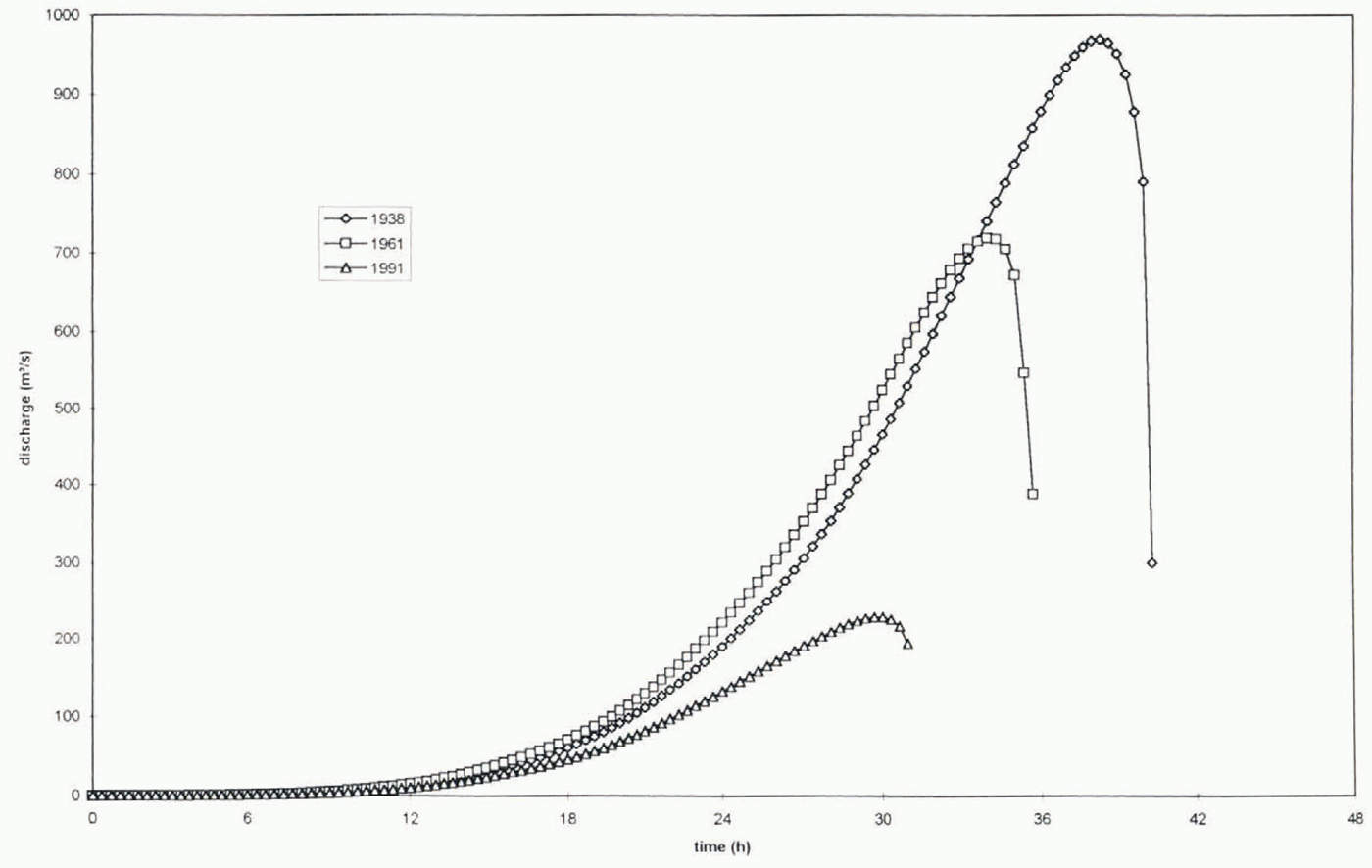
For the time period around 1991 a frequency of outbursts of about one per year is known from field observations. In 1991 the lake volume was reduced by 80% compared to 1938. This indicates that an outburst around 1938 happened about every 6 years whereas an outburst around 1961 happened about every 3 years.
Conclusions
To obtain the relation between the lost lake volume and the peak discharge during Outburst floods we computed an unbiased regression equation which is relevant for outbursts with progressive enlargement of subglacial tunnels (Q max= 72V 00.70). The derived equation is very similar to the original form of the Clague-Mathews formula. This similarity is the reason why the original Clague-Mathews formula worked well for many investigations.
Our investigation shows that outbursts of Goêsvatnet start long before flotation of the ice dam is possible (h i/h w≈ 0.6). The lowering of the damming ice masses of Gåsbreen reduced the water stored at the maximum stage in the lake of 80% and lowered peak discharge during out-bursts from about 1000 m3s−1to 240 m3s−1in the period 1938-91. The computed peak discharge of 970 m3s−1for an outburst around 1938 confirms the assumption of Reference PillewizerPillewizer (1939)that the sandur plain was flooded during an outburst at that time. Our field observations in 1991 and the computed peak discharge for 1991 show that during recent outbursts the sandur was not flooded. The change of the lake geometry from a cone-shaped to a paraboloid-shaped topography in the period 1938-91 is equivalent to a reduction of peak discharge by 10%. whereas the reduction of the drainage tunnel length and the increased slope increase peak discharge by 17% and 30%, respectively. The observations and computations of the outbursts of Goësvatnet fit well with the jökulhlaup activity shown by Reference Evans and ClagueEvans and Clague (1994)in western Canada.
Finally, our study shows that a careful interpretation of old maps, aerial photos and field observations enables not only a qualitative description of historical and recent outburst floods but also an estimation of the peak discharge and a rough computation of the discharge curves by means of a physically based model.
Acknowledgements
This work was funded by the Austrian Science Foundation (project P8332-GEO). We would like to thank J. Jania, T. Niedzuiezc the participants in the 1990-91 and 1991-92 Polish Spitsbergenexpedition and G. Vatne for their help with fieldwork and data acquisition. Comments by an anonymous referee made an important contribution to the aims of this paper.