


 Open access
Crossref Citations
This article has been cited by the following publications. This list is generated based on data provided by Crossref.
Minderhoud, Philip
Shirzaei, Manoochehr
and
Teatini, Pietro
2024.
Combatting Relative Sea-Level Rise at a Global Scale: Presenting the International Panel on Land Subsidence (IPLS).
Qeios,
Vol. 6,
Issue. 7,
Becker, M.
Seeger, K.
Paszkowski, A.
Marcos, M.
Papa, F.
Almar, R.
Bates, P.
France‐Lanord, C.
Hossain, Md S.
Khan, Md J. U.
Karegar, M. A.
Karpytchev, M.
Long, N.
Minderhoud, P. S. J.
Neal, J.
Nicholls, R. J.
and
Syvitski, J.
2024.
Coastal Flooding in Asian Megadeltas: Recent Advances, Persistent Challenges, and Call for Actions Amidst Local and Global Changes.
Reviews of Geophysics,
Vol. 62,
Issue. 4,
Wang, Ke
Chen, Jingyi
Valseth, Eirik
Wells, Gordon
Bettadpur, Srinivas
Jones, Cathleen E.
and
Dawson, Clint
2024.
Subtle Land Subsidence Elevates Future Storm Surge Risks Along the Gulf Coast of the United States.
Journal of Geophysical Research: Earth Surface,
Vol. 129,
Issue. 9,
Steckler, Michael S.
Jaman, Md. Hasnat
Grall, Céline Jo
Goodbred, Steven L.
Wilson, Carol A.
and
Oryan, Bar
2024.
Contribution of campaign GNSS toward parsing subsidence rates by time and depth in coastal Bangladesh.
Frontiers in Earth Science,
Vol. 12,
Issue. ,
Deng, Fanghui
2025.
Current Subsidence Rates of the Mississippi River Delta From Satellite Radar Interferometry: Onshore and Offshore.
Earth and Space Science,
Vol. 12,
Issue. 7,
2025.
The Ecology of Sandy Shores.
p.
697.
Govorcin, Marin
Bekaert, David P. S.
Hamlington, Benjamin D.
Sangha, Simran S.
and
Sweet, William
2025.
Variable vertical land motion and its impacts on sea level rise projections.
Science Advances,
Vol. 11,
Issue. 5,
Ng, Trina
Garner, Gregory
Weeks, Jennifer H.
Hogarth, Peter
Palmer, Matthew D.
Li, Tanghua
Moise, Aurel
and
Horton, Benjamin P.
2025.
Robust Sea‐Level Projections for Singapore by 2100 and 2150.
Journal of Geophysical Research: Oceans,
Vol. 130,
Issue. 5,
Minderhoud, P. S. J.
Shirzaei, M.
and
Teatini, P.
2025.
From InSAR‐Derived Subsidence to Relative Sea‐Level Rise—A Call for Rigor.
Earth's Future,
Vol. 13,
Issue. 1,
Defeo, Omar
and
McLachlan, Anton
2025.
The Ecology of Sandy Shores.
p.
561.
Dangendorf, Sönke
Oelsmann, Julius
Mitrovica, Jerry X.
Törnqvist, Torbjörn E.
Piecuch, Christopher G.
Creel, Roger
Coronel, William
Thompson, Philip R.
Ebinger, Cynthia
and
Wahl, Thomas
2026.
Variable contributions of vertical land motion to sea-level change inferred at tide gauges.
Nature Geoscience,
Shastri, Arpan
and
Ojha, Chandrakanta
2026.
Present-day coastal subsidence and inundation risk to socioeconomic exposure in Chennai City, India.
Scientific Reports,
Vol. 16,
Issue. 1,
Shirzaei, Manoochehr
Ohenhen, Leonard
Atkins, Carmen
Awasthi, Shubham
Carlson, Grace
Dasho, Oluwaseyi
Daud, Ntambila
Feng, Guangcai
Jiang, Hongbo
Khorrami, Mohammad
Lucy, Jonathan
Reshadati, Mahmoud
Sadhasivam, Nitheshnirmal
Sherpa, Sonam F.
Zhai, Guang
Zhong, Wen
Becker, Claire
Wise, Clayton
Etzler, William
Isiaka, Ibrahim O.
Kamaraj, Nivedita P.
Onyike, Florence
Oyedele, Esther O.
Wilson, Sarah
AghaKouchak, Amir
Bukvic, Anamaria
Bürgmann, Roland
Freymueller, Jeffrey
Heck, Nadine
Nicholls, Robert J.
Oelsmann, Julius
Narayan, Siddharth
Teatini, Pietro
Vahedifard, Farshid
Jaramillo, Michelle
and
Werth, Susanna
2026.
Vertical Land Motion and Coastal Cities: Bridging Global Science and Policy for Resilient Communities.
Annual Review of Earth and Planetary Sciences
,
Vol. 54,
Issue. 1,
p.
301.
Oelsmann, Julius
Nicholls, Robert J.
Lincke, Daniel
Marcos, Marta
Shirzaei, Manoochehr
Sánchez, Laura
Ohenhen, Leonard
Dettmering, Denise
Hinkel, Jochen
Horton, Benjamin P.
and
Seitz, Florian
2026.
Subsidence more than doubles sea-level rise today along densely populated coasts.
Nature Communications,
Vol. 17,
Issue. 1,
Li, Guandong
Törnqvist, Torbjörn E.
and
Chen, Jingyi
2026.
Evaluating InSAR-derived rates of surface-elevation change along the central U.S. Gulf Coast.
Earth Observation,
Vol. 1,
Issue. 1,
p.
1.
Impact statement
Coastal subsidence is increasingly recognized as a major threat for the rapidly growing populations in coastal lowlands worldwide. Monitoring and predicting coastal subsidence is challenging and requires a multitude of methods. As a result, researchers within this community have diverse backgrounds, which has resulted in differences in the conceptual framework for understanding this process, including differences in terminology and definitions. This paper proposes a unifying framework to understand coastal subsidence with the goal to enhance communication between these different research communities.
Land subsidence, defined herein as the downward motion of a specific reference horizon relative to a fixed datum, is a major compounding problem for low-elevation coastal zones that are feeling the effects of accelerating global sea-level rise, including some that host the world’s largest population centres. This “slow-motion disaster” is receiving rapidly increasing attention within the research community (Buffardi and Ruberti, Reference Buffardi and Ruberti2023) and is prevalent along depositional coastlines that are subject to long-term passive margin subsidence. Superimposed on this relatively steady (105 to 106 yr or more) and slow geologic process are non-steady components of vertical land motion (VLM), including glacial isostatic adjustment that affects every shoreline worldwide over shorter timescales (103 to 105 yr), plus compaction of recently deposited sediment as well as compaction due to fluid extraction that operate over timescales as short as 100 to 102 yr and exhibit large spatial variability but often dominate subsidence on local scales. Here we argue that the complexities of coastal subsidence are not always recognized and appreciated within the multidisciplinary subsidence research community, presenting an obstacle to subsidence projections and coastal policymaking. We therefore ask the simple question “What is coastal subsidence?”
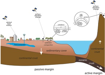
Shirzaei et al. (Reference Shirzaei, Freymueller, Törnqvist, Galloway, Dura and Minderhoud2021) argued that within the context of VLM, distinction must be made between static and dynamic coastal landscapes. We use these terms in a morphodynamic sense: in the former, deposition and erosion have been essentially halted, whereas in the latter (e.g., coastal wetlands), these processes operate relatively uninhibited. Morphodynamically “static” landscapes include urban as well as agricultural settings with minimal relief, which are common in low-elevation coastal zones and characterized by geomorphic processes that are sufficiently slow that they can be neglected over human-relevant timescales. The implications of this distinction for subsidence measurements are profound: in static landscapes, VLM can be directly observed by measurements of land surface displacement with remote sensing and geodetic techniques. Therefore, subsidence studies in static settings are often relatively straightforward. The situation is entirely different in dynamic landscapes, where such methods measure surface-elevation change (SEC) rather than VLM (Figure 1). These are fundamentally different things.
Schematic cross section of two continental margins subject to subsidence (passive margin) and uplift (active margin), respectively. Note that InSAR measurements provide rates of surface-elevation change, which can be directly interpreted as vertical land motion only in static landscapes (e.g., urban areas). Also note the difference between the two GNSS stations: #1 is set in exposed bedrock and measures rock uplift, whereas #2 measures subsidence but misses the shallow compaction component because the instrument rests on a foundation several meters below the wetland surface. Insets (circles) provide details of the key processes operating in erosive uplifting settings, versus subsiding coastal wetlands where deposition can drive shallow sediment compaction. In the latter, there is subsidence despite net surface-elevation gain.
To progress towards a common understanding, we consider VLM and SEC in subsiding, coastal depositional landscapes to be the mirror image of what occurs in uplifting, erosional landscapes, as outlined in the seminal paper of England and Molnar (Reference England and Molnar1990) where rock uplift was differentiated from surface uplift. Rock uplift is the upward VLM of a specific reference horizon relative to a fixed datum, whereas surface uplift equals rock uplift minus erosion (exhumation). Surface uplift is therefore one variant of SEC as used herein, but if there is no erosion, or no deposition for that matter, rock uplift equals SEC. Subsidence is the opposite of rock uplift and represents the downward VLM (a negative number) of a specific reference horizon relative to a fixed datum, and SEC equals the difference between VLM of the reference horizon and vertical accretion (or erosion) of sediment. SEC will be a positive number if vertical accretion exceeds subsidence, SEC will equal zero if vertical accretion balances subsidence, and SEC will be negative if subsidence exceeds vertical accretion. As such, subsidence is defined in a way that is consistent with its long-standing use in the stratigraphic literature, where subsidence measurements can be referred to any horizon in the subsurface regardless of depth or timescale (e.g., Paola, Reference Paola2000; Frederick et al., Reference Frederick, Blum, Fillon and Roberts2019).
Measuring SEC and/or VLM can be accomplished by a wide range of methods, some of which strictly determine changes at the land surface, whereas others explicitly monitor subsurface processes. Combining both is essential to disentangling driving mechanisms. Space-based methods like Interferometric Synthetic Aperture Radar (InSAR) have become some of the most powerful tools to obtain spatially continuous data on SEC and/or VLM (e.g., Jones et al., Reference Jones, An, Blom, Kent, Ivins and Bekaert2016). Global Navigation Satellite System (GNSS) data can provide point observations on VLM in coastal settings (e.g., Hammond et al., Reference Hammond, Blewitt, Kreemer and Nerem2021) and are often used to ground truth InSAR measurements. While InSAR is potentially invaluable, it cannot differentiate the drivers, or causal mechanisms, if multiple processes contribute to SEC. Most importantly, InSAR fundamentally measures SEC, which will be equivalent to VLM in static landscapes only (Figure 1). Even in such settings, care must be taken that reflectors measure change at the land surface, given that large buildings often rest on foundations that may be tens of metres deep. As a result, significant differences may exist between velocities obtained from reflectors associated with buildings that rest on deep pilings compared to adjacent urban infrastructure, where the latter often exhibits higher rates (De Wit et al., Reference De Wit, Lexmond, Stouthamer, Neussner, Dörr, Schenk and Minderhoud2021).
Despite this caveat, ground truthing of InSAR data with GNSS measurements is comparably straightforward in static landscapes (e.g., Fabris et al., Reference Fabris, Battaglia, Chen, Menin, Monego and Floris2022). In contrast, as discussed by Keogh and Törnqvist (Reference Keogh and Törnqvist2019), this may be more challenging in wetland environments where subsidence in the shallowest portion of the subsurface is typically not captured by GNSS instruments (Figure 1). As a result, understanding subsidence in such settings requires independent measurements of vertical accretion and/or erosion to complement time series on SEC from InSAR. (Separate from these considerations, it should be noted that the collection of InSAR data in wetlands is challenging – a topic beyond the scope of the present paper.) It is therefore imperative that vertical accretion not be used synonymously with SEC as has been the case in recent, widely cited papers (e.g., Crosby et al., Reference Crosby, Sax, Palmer, Booth, Deegan, Bertness and Leslie2016; FitzGerald and Hughes, Reference FitzGerald and Hughes2019). Along the same lines, InSAR measurements that encompass both static and dynamic landscapes (e.g., Ohenhen et al., Reference Ohenhen, Shirzaei, Ojha and Kirwan2023) measure SEC, which can only be equated with VLM in the static case.
A related, widespread source of confusion is associated with the interplay between deposition and subsidence. For example, studies of river delta vulnerability have implied that a reduction of sediment supply increases subsidence (e.g., Becker et al., Reference Becker, Papa, Karpytchev, Delebecque, Krien, Khan, Ballu, Durand, Le Cozannet, Islam, Calmant and Shum2020; Glover et al., Reference Glover, Ogston, Fricke, Nittrouer, Aung, Naing and Lahr2023). However, the opposite is true: vertical accretion and subsidence from compaction in the upper portion of the sediment column are closely coupled (Saintilan et al., Reference Saintilan, Kovalenko, Guntenspergen, Rogers, Lynch, Cahoon, Lovelock, Friess, Ashe, Krauss, Cormier, Spencer, Adams, Raw, Ibanez, Scarton, Temmerman, Meire, Maris, Thorne, Brazner, Chmura, Bowron, Gamage, Cressman, Endris, Marconi, Marcum, St Laurent, Reay, Raposa, Garwood and Khan2022) due to the effective stress exerted by newly accumulated sediment (Zoccarato and Da Lio, Reference Zoccarato and Da Lio2021). In other words, the addition, not the reduction of, sediment will therefore increase subsidence. Nevertheless, even though deposition typically enhances subsidence, it still often results in net surface-elevation gain (Chamberlain et al., Reference Chamberlain, Shen, Kim, McKinley, Anderson and Törnqvist2021; Saintilan et al., Reference Saintilan, Kovalenko, Guntenspergen, Rogers, Lynch, Cahoon, Lovelock, Friess, Ashe, Krauss, Cormier, Spencer, Adams, Raw, Ibanez, Scarton, Temmerman, Meire, Maris, Thorne, Brazner, Chmura, Bowron, Gamage, Cressman, Endris, Marconi, Marcum, St Laurent, Reay, Raposa, Garwood and Khan2022). Put differently, wetlands that lose elevation compared to rising sea level may still gain elevation with respect to a fixed geodetic datum, as long as vertical accretion outpaces subsidence (Figure 1).
Why is this important? We argue that not recognizing these nuances could hinder progress, not just scientifically but also in terms of the policy implications of coastal subsidence. For example, it is not uncommon for river deltas to exhibit positive SEC due to ongoing sediment deposition. Data presented by Jankowski et al. (Reference Jankowski, Törnqvist and Fernandes2017) show that the rate of SEC in coastal Louisiana is 0.7 ± 6.9 mm/yr. This is due to vertical accretion that largely offsets subsidence (58% of their monitoring sites exhibit values of zero or higher). However, none of this means that subsidence is not occurring throughout the shallow and deep subsurface; Nienhuis et al. (Reference Nienhuis, Törnqvist, Jankowski, Fernandes and Keogh2017) reported a subsidence rate averaging 9 mm/yr for this area. Put differently, conflating subsidence with SEC in a case like this would make it very challenging to effectively communicate the subsidence problem in this region to practitioners. Given the increasing need for predictive, process-based subsidence models (Allison et al., Reference Allison, Yuill, Törnqvist, Amelung, Dixon, Erkens, Stuurman, Jones, Milne, Steckler, Syvitski and Teatini2016; Shirzaei et al., Reference Shirzaei, Freymueller, Törnqvist, Galloway, Dura and Minderhoud2021), it is critical to separate between elevation loss due to downward VLM (i.e., subsidence) and elevation loss due to a lack of sediment deposition or erosion, in the same way that tectonic geomorphologists separate between rock uplift and surface uplift (e.g., Gasparini and Whipple, Reference Gasparini and Whipple2014; Yang et al., Reference Yang, Willett and Goren2015). We advocate a similar theoretical framework for the coastal subsidence community.
An important motivation for this contribution is the increasing recognition of coastal subsidence as an existential threat that adds to the risks posed by global sea-level rise for millions of people worldwide. In fact, along many deltaic coastlines the magnitude of coastal subsidence can equal or exceed current and projected rates of geocentric sea-level rise (Jelgersma, Reference Jelgersma, Milliman and Haq1996; and many subsequent studies). In this sense, coastal subsidence research has enjoyed rapid progress, not least due to a wide range of technological advances and an increasingly high spatial and temporal resolution in the detection of VLM at or near the Earth’s surface (e.g., Da Lio et al., Reference Da Lio, Teatini, Strozzi and Tosi2018; Steckler et al., Reference Steckler, Oryan, Wilson, Grall, Nooner, Mondal, Akhter, DeWolf and Goodbred2022; Zoccarato et al., Reference Zoccarato, Minderhoud, Zorzan, Tosi, Bergamasco, Girardi, Simonini, Cavallina, Cosma, Da Lio, Donnici and Teatini2022; Zumberge et al., Reference Zumberge, Xie, Wyatt, Steckler, Li, Hatfield, Elliott, Dixon, Bridgeman, Chamberlain, Allison and Törnqvist2022). However, as shown by the examples discussed above, new and/or increasingly sophisticated measurements have not always gone hand in hand with progress on our understanding of the relevant surface and subsurface processes: the vital question of “what exactly is being measured?” must never become an afterthought.
In closing, we note that increased concern about subsidence will be addressed by the recently established International Panel on Land Subsidence (IPLS; Minderhoud and Shirzaei, Reference Minderhoud and Shirzaei2022; https://sites.google.com/view/iplsubisdence/home). One of the key objectives of the IPLS will be to produce subsidence projections that can be combined with IPCC-style sea-level projections (Oppenheimer et al., Reference Oppenheimer, Glavovic, Hinkel, Van de Wal, Magnan, Abd-Elgawad, Cai, Cifuentes-Jara, DeConto, Ghosh, Hay, Isla, Marzeion, Meyssignac, Sebesvari, Pörtner, Roberts, Masson-Delmotte, Zhai, Tignor, Poloczanska, Mintenbeck, Alegría, Nicolai, Okem, Petzold, Rama and Weyer2019; Fox-Kemper et al., Reference Fox-Kemper, Hewitt, Xiao, Ađalgeirsdóttir, Drijfhout, Edwards, Golledge, Hemer, Kopp, Krinner, Mix, Notz, Nowicki, Nurhati, Ruiz, Sallée, Slangen, Yu, Masson-Delmotte, Zhai, Pirani, Connors, Péan, Berger, Caud, Chen, Goldfarb, Gomis, Huang, Leitzell, Lonnoy, Matthews, Maycock, Waterfield, Yelekçi, Yu and Zhou2021) to generate more powerful forecasts of relative sea-level change. A recent community paper on sea-level terminology (Gregory et al., Reference Gregory, Griffies, Hughes, Lowe, Church, Fukimori, Gomez, Kopp, Landerer, Le Cozannet, Ponte, Stammer, Tamisiea and Van de Wal2019) has reduced confusion on critically important concepts from this neighbouring field. In that spirit, we hope that this brief paper can be an initial contribution towards a more clearly defined conceptual framework for understanding and projecting subsidence in the coastal zone.
Open peer review
To view the open peer review materials for this article, please visit http://doi.org/10.1017/cft.2024.1.
Acknowledgements
Jaap Nienhuis and an anonymous reviewer provided numerous thoughtful comments that enabled us to clarify key elements of the subject matter, but we stress that the opinions expressed herein are our own. We also thank Philip Minderhoud and Nicole Gasparini for valuable feedback.
Competing interest
The authors declare none.