

Introduction
How borders are conceived, brought into being, maintained and regulated has long been a focus of cross-disciplinary research, much of which has struggled to break away from a Westphalian model that seeks direct links between territory, as bounded, cartographical space, and the state, as the dominant power bestowed with sovereignty over that territory (for critique, see Amilhat Szary & Giraut Reference Amilhat Szary and Giraut2015, 7; Fourny Reference Fourny2013; Konrad & Amilhat Szary Reference Konrad and Amilhat Szary2023; Paasi Reference Paasi1998; Popescu Reference Popescu2011). Anachronistic ‘lines on a map’ approaches to defining state territories with fixed borders have framed archaeological and Assyriological practice since their disciplinary inception, influenced no doubt by monumental historical constructions such as the Roman limes, the Great Wall of China (e.g. Glatz Reference Glatz2020, 119–23 for a recent discussion and critique), or, more geographically and chronologically relevant here, the so-called ‘Amorite Wall’ (‘MAR.TU–Mauer’, after Wilcke Reference Wilcke1969, 1), a network of fortifications ostensibly built by kings Shulgi (2094–2046 bce) and Shu-Sin (2037–2028 bce) to keep the Amorites out of Sumerian lands (see Michalowski Reference Michalowski2011, 122–9 for discussion).
Historical geographies regularly fix ancient borders to permanent and semi-permanent physical landscape features. The sprawling mosaic of mountain ranges, passes, intermontane plains and river valleys that make up the Zagros piedmont zone have regularly been tied to the imperial and localized borders of ancient political entities: Ur III, Ešnunna, Simurrum, Lullubum and Gutium (Altaweel et al. Reference Altaweel, Palmisano, Mühl, MacGinnis, Wicke and Greenfield2016 Reference Altaweel, Marsh and Mühl2012; Charpin Reference Charpin, Gonçalves and Michel2021; Eidem Reference Eidem1985, 98; Eidem & Laessøe Reference Eidem and Laessøe2001, nos 1 and 2; Frayne Reference Frayne, Young and Astour1997; Reference Frayne2011; Ziegler Reference Ziegler, Miglus and Mühl2011). Underpinning these discourses, however, is a one-directional story of division, whereby lowland Mesopotamian elites spun narratives of transitional and highland communities as uncivilized, unruly and, ultimately, subordinate (Glatz & Casana Reference Glatz and Casana2016). The Sirwan/DiyalaFootnote 1 (henceforth Sirwan) river valley figures prominently in this imagined geography, with the region shifting in and out of historical focus based on the rhetoric of domination and resource extraction projected by successive lowland kings, and ostensibly mimicked by local rulers through a series of rock reliefs in the Zagros front ranges dating to the late third and early second millennia bce.
This article focuses on the perceptions and practices that configured Middle Bronze Age borders. While bordering is the process of creating or reinforcing boundaries, be they physical, social, or political, debordering processes aim to reduce those boundaries, leading to permeability, unity and increased cross-border interaction (Amilhat Szary & Fourny Reference Amilhat Szary, Fourny, Amilhat Szary and Fourny2006; Jones Reference Jones2009). Scholarly research on ancient borders has increasingly been drawn into tense contemporary political debates, which seek to normalize modern boundaries or advance polarizing (de)bordering processes, and significant criticism has recently been levelled at archaeological approaches to borders for repeating, and inadvertently bringing into being, the top-down ‘state idea’ (Abrams Reference Abrams1988, 82; also Campbell Reference Campbell, D’Alfonso and Rubinson2021, 38; Paasi Reference Paasi1998).
Normative approaches to state territorialities infuse our understandings of and approaches to diverse archaeological materialities. ‘Plain’ pottery assemblages,Footnote 2 for instance, have assumed a prominent role in the archaeological imagination as a proxy for identifying the spatial-temporal reach of the early state and its assumed proto-capitalist economy (see Glatz Reference Glatz2020 for an Anatolian example; Green et al. Reference Green, Wilkinson, Wilkinson, Highcock and Leppard2023 for a general critique). During the later second millennium bce, it is the plain Middle Babylonian ceramic assemblages, also referred to as ‘Kassite’, whose distribution continues to be seen by many to be co-terminous with Kassite political control. Referring to changes observed in the ceramic assemblages of Tell Yelkhi in the Hamrin basin between the fifteenth and thirteenth centuries bce, Armstrong recently suggested that ‘although we know virtually nothing about the political, social and economic connections between Arrapha and the Hamrin it is probably not coincidental that sometime after Arrapha fell to the Assyrians in the mid-14th century the Babylonians expanded into the upper Diyala Basin and brought the Hamrin under Kassite political control. When they came in, their potters came with them.’ (Armstrong Reference Armstrong, Bartelmus and Sternitzke2017, 432; see also Armstrong & Gasche Reference Armstrong and Gasche2014, 102).
Both Tell Yelkhi’s ceramic connections to northern Mesopotamia, such as Tell Nuzi (Arrapha), and the subsequent changes in local pottery traditions, which point to connections to Babylonia (the Kassite heartland), are thought to have political origins. The presence of some Babylonian shapes at the Iranian site of Tepe Guran, too, are thought to evidence the presence of Babylonians at the site during the Kassite period (Armstrong Reference Armstrong, Bartelmus and Sternitzke2017, 433; Pons & Gasche Reference Pons, Gasche, Butterlin, Lebeau, Monchambert, Montero Fenóllos and Muller2006, 380). The geographical expansion of Middle Babylonian pottery suggests that ‘the Babylonians seem to have been pushing outward along the major trade routes… in order to get closer to the sources of raw materials and other trade goods’ (Armstrong Reference Armstrong, Bartelmus and Sternitzke2017, 434; Pons and Gasche Reference Pons, Gasche, Butterlin, Lebeau, Monchambert, Montero Fenóllos and Muller2006, 380). Fuchs (Reference Fuchs, Bartelmus and Sternitzke2017, 146) similarly points to the distribution of Kassite pottery to support the hypothesis—based on Neo-Assyrian texts, which date several centuries later—of Kassite political control over parts of western Iran. Ultimately, Armstrong and Gasche (Reference Armstrong and Gasche2014, 102), in their cornerstone study of second-millennium bce Mesopotamian pottery, conclude that ‘in the geographic distribution of Babylonian pottery, both in the heartland and along the periphery, we can begin to see reflections of the expansion and contraction of Babylonian political and economic power’.
Ceramic standardization and inter/intra-site similarity is equated with tight state control over a given territory, while stylistic differences are framed either spatially, as the product of rigid border divides, or temporally, as a signifier of large–scale shifts in centralized power. This is despite the fact that past territorialities have long been recognised as more web- or network-like than the more contiguous powers of (some) modern states (see Glatz Reference Glatz2020 for an extended discussion).
These explanatory frameworks sit at the heart of the survey methodologies dominant in the archaeology of Southwest Asia, which are based almost entirely in pottery seriation (Adams Reference Adams1965; Wilkinson Reference Wilkinson2003), with the identification of ‘type-fossils’ (after Jacobsen & Adams Reference Jacobsen and Adams1958, 1254) that become go-to proxies for political territoriality and temporality. Such essentializing political–typological approaches see pottery styles marching in lockstep with historically defined Mesopotamian states. Materialities on the borders are assumed to match those of the ‘core’ territory, while localized nuance is commonly overlooked as incidental noise (after Langer & Fernández-Götz Reference Langer and Fernández-Götz2020, 38). Temporality, too, remains a coarse construct, which, given the relative lack of radiocarbon dates generated from excavations in the region, also remains locked to these pottery type-fossils.
The contemporary relevance of border discussions places significant onus on archaeologists to develop socially relevant, empirically grounded and theoretically informed discourses about past socio-spatialities. To address this, Hanscam and Buchanan (Reference Hanscam and Buchanan2023) emphasize the importance of recent developments in critical border studies, which foreground the psychological dimensions of borders, conceptualizing them fundamentally as apparatus for regulating flows between internal and external, inclusion and exclusion (Foucault Reference Foucault2007). Emerging from postcolonial discourses is a view of borders as devices that distinguish communities based on values, customs and traditions (see Bravo Reference Bravo2022 for discussion), all of which are experienced and negotiated in moments of socio-spatial encounter. Common within this research are varied concepts of hybridity, in-betweenness, liminality (e.g. Fourny Reference Fourny2013; Krichker Reference Krichker2021; Parker & Vaughan-Williams Reference Parker and Vaughan-Williams2016), and the increasing prominence of ‘Third Space’ studies (after Bhabha Reference Bhabha, Hall and Du Gay1996; Reference Bhabha2004; Hamdy Reference Hamdy, Goebel and Schabio2010; Naum Reference Naum2010).
Amilhat Szary and Giraut (Reference Amilhat Szary and Giraut2015) conceptualize modern borders as ‘mobile’, in that they are disseminated in a relational manner rather than physically fixed and territorialized. To capture this fluidity, they develop a flexible concept of ‘borderities’, defined as ‘the multiple rules and experiences of what a border can be … not divided by lines whose visibility gives a sense of political balances, but structured by limits that are constantly being redefined’ (Amilhat Szary & Giraut Reference Amilhat Szary and Giraut2015, 3). Borderities, like ‘Third Space’, are multi-located and relational; they are ‘engaged, altered, produced, materialised, and removed in this dynamic border interaction of human society, politics and space’ (Konrad & Amilhat Szary Reference Konrad and Amilhat Szary2023, 22). Langer and Fernández-Götz (Reference Langer and Fernández-Götz2020, 41) therefore suggest a combined approach to the study of pre-modern borders, which emphasizes, on the one hand, the perspective of political thought drawn from texts and monumental constructions, and on the other, close material culture analysis that researches lived experiences—reinforcing the need for what Naum (Reference Naum2010, 105) has referred to as a ‘materiality-conscious archaeology’. Within and between these sources of evidence is where we might identify borderities, mediated through the carefully curated as well as non-discursive material practices that structured past socio-spatialities.
In this paper, we examine newly excavated Middle Bronze Age I (c. 2000–1800 bce) plain-ware pottery assemblages from two sites—Tepe Kalan and Kani Masi—located just 14 km apart on either side of the Sirwan river and separated by low-lying hill ranges. We begin with a critical discussion of the landscapes of the Sirwan river valley, their topographic boundaries and conduits, and how these may have influenced multi-directional power flows, in historical and archaeological perspective. We then introduce the two case study sites and their respective assemblages, analysed alongside contemporary evidence collected from the Sirwan survey region and set within their wider (inter-)regional context, addressing aspects of vessel style, production and commensal performance.
The Sirwan river valley
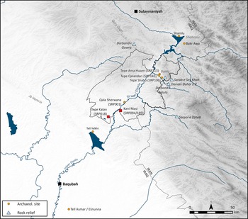
The Sirwan river valley is a highland–lowland transitional zone traversed by its eponymous river, which winds northeast–southwest, from the Zagros mountains to its confluence with the Tigris close to modern Baghdad (Fig. 1). On its journey, the Sirwan passes through a complex patchwork of mountain chains, intermontane plains, river valleys and passes, which variously act as inhibitors or enablers to settlement and movement. The most northerly of these zones consists of the hilly flanks and high fertile plateaus of the Zagros front ranges, such as the Shahrizor plain, a region enveloped to the south by the imposing edifice of the Qara Dagh mountain range. Several narrow passes descend through the Qara Dagh to reach rugged upland terraces, which are characterized by limited flat land suited to agricultural production, but hold abundant springs and tributary river valleys connecting to the Zagros.
Map of the Sirwan river valley, showing the SRP survey region and the main archaeological sites and locational features mentioned in the text. (Map: Francesca Chelazzi.)

Figure 1 Long description
The map of the Sirwan river valley highlights the SRP survey region and key archaeological sites and locational features. It includes various markers for archaeological sites such as Tepe Ama Husen, Tepe Qalandari, Tepe Shahu, Qala Sherwana, Tepe Kalan, Kani Masi, Tell Yelkhi, and Tell Asmar. The map also shows the locations of rock reliefs and other significant points like Darband-i Gawra, Darband-i Belula, and Sarpol-e Zahab. The map is detailed with rivers, boundaries, and topographical features, providing a comprehensive view of the region’s archaeological landscape.
Just north of the modern city of Kalar, the landscape opens onto a series of elongated alluvial basins, including the Bnkura and Qubba plains—the location of Kani Masi (SRP094) and Tepe Kalan (SRP018)—while further south is the Hamrin Basin. These relatively fertile plains are separated from one another by parallel northwest–southeast anticlinal ridges, the most prominent of which is the Jebel Hamrin, largely impassable other than at the bottleneck where the river punches through and its alluvial deposits merge with those of the Tigris, endowing the surrounding landscape with a flat steppe topography very similar to much of lower Mesopotamia (Adams Reference Adams1965, 4–5).
The Sirwan region has long held strategic value. While the river valley itself channels north–south movement between the Shahrizor high plateau and the lowland plains of southern Mesopotamia, the plains of the lower Sirwan were in various periods traversed by important east–west overland routes such as, in the Bronze Age, the so-called Elam–Kišma–Dēr–Diyala Road (Carter & Stolper Reference Carter and Stolper1984, 58–60). More northerly routes, via for example the Hawasan, Zahab, Qoratu and Alwand valleys, also connect the region with a broader inter-regional network, bringing local communities into regular contact with those of Babylonia, the Zagros highlands, Luristan, Elam and beyond.
According to diverse textual sources, including letters, royal correspondences, administrative documents and merchant texts, the MB I period (c. 2000–1800 bce) saw an acceleration of inter-regional cultural contact in this area, much of which centres on the city of Ešnunna (Tell Asmar) (De Graef Reference De Graef, Radner, Moeller and Potts2022). Starting early in Ibbi-Sin’s reign (c. 2028–2004 bce), Ešnunna claimed independence from the Third Dynasty of Ur. Other cities in the Diyala and Hamrin soon followed suit, resulting in a constellation of independent city-states and rulers (Charpin Reference Charpin, Charpin, Edzard and Stol2004, 388–90; Reference Charpin, Gonçalves and Michel2021, 11). Direct textual inscriptions bear the names of several local governors in the lower Sirwan, at Tutub (Khafajah), Nerēbtum (Ishchali), Šadduppǔm (Harmal) and Zaralulu (Dhiba’i), while local rulers’ names can also be associated with specific city-states, namely Arim Lim of Me Turan, which corresponds to the modern agglomeration of Tell Haddad/Tell es Sib, and Aiiabum of Batir, the ancient name for Tell SuleimahFootnote 3 (Frayne Reference Frayne1990, 688, 694–702; Greengus Reference Greengus1986, 185; Rashid Reference Rashid1984, 56; Saporetti Reference Saporetti2002, 167–82). The discovery of an archive of tablets at Tell Yelkhi (Level V), dated relatively through pottery styles to the early centuries of the second millennium bce, also includes the appellation of local ‘governor’, therefore pointing towards its own economic and political independence (Bergamini et al. Reference Bergamini, Saporetti, Costantini, Costantini Biasini, Masiero and Quarantelli1985, 57–8; Saporetti Reference Saporetti2002, 150–52).
This pattern of distributed influence broadly aligns with the fragmentation of authority in southern Mesopotamia, where the cities of Isin and Larsa took turns claiming power and territory (Oates Reference Oates1979, 49–59). However, when Ipiq-Adad II (c. 1862–1818 bce) ascended the throne of Ešnunna, the city’s power rapidly expanded, ostensibly to cover swathes of the lower Sirwan region (Charpin Reference Charpin, Gonçalves and Michel2021, 10–11) and well beyond into western Iran (Gentili Reference Gentili2021). Soon after (c. 1762 bce), Ešnunna, and perhaps larger areas northwards along the Sirwan, appear to have been progressively occupied by Ḫammurabi in an offensive that marked the end of Ešnunnan independence (Richardson Reference Richardson2005).
MB I rock reliefs located in the Zagros foothills speak to a complicated set of relationships and rivalries, internally between local and highland Zagros elites—Simurrum and Lullubum in particular—as well as externally with lowland Mesopotamia. Especially important here are debates surrounding the emergence of Simurrum in the late third and early second millennia bce, which scholarly consensus locates somewhere along the upper Sirwan, centred perhaps around the Shahrizor plain (Altaweel et al. Reference Altaweel, Marsh and Mühl2012; Frayne Reference Frayne2011) or the Bnkura plain where the prominent Qala Sherwana (SRP001) is located (Ahmed Reference Ahmed2012, 297–302; Frayne Reference Frayne, Young and Astour1997).
The inscription of Iddi(n)-Sîn, king of Simurrum, found at Bitwata near Ranya, for instance, portrays his northern campaigns between c. 2000 and 1900 bce. The king is depicted bare-chested, holding a bow in the left hand and a scimitar in the right, and trampling a fallen enemy in front of a goddess (Shaffer et al. Reference Shaffer, Wasserman and Seidl2003, 3). Altaweel et al. (Reference Altaweel, Marsh and Mühl2012, 11) believe this scene was deliberately emulated in rock reliefs at Darband-i Gawr (Strommenger Reference Strommenger1963), in the Qara Dagh to the south, as well as at a series of reliefs at Sarpol-e Zahab in western Iran, including the Anubanini relief (Frayne Reference Frayne1990, 4.18.1, fig.4; Niknami & Mirghaderi Reference Niknami and Mirghaderi2019). These reliefs share distinct iconographic similarities with traditional Mesopotamian artistic compositions, especially the victory stele of Naram-Sin of Akkad and the stele of Dāduša (Suter Reference Suter2018), with the use of Akkadian cuneiform in some examples representing localized interpretations of characteristic Mesopotamian aesthetics (Glatz Reference Glatz and Osborne2014, 128). A roughly worked relief, the Darband-i Belula (also known as Shaikhan), similarly depicting an unknown local ruler vanquishing an unknown local enemy, has been identified on a relatively inaccessible rocky platform close to the Bamu range (Glatz et al. Reference Glatz, Calderbank and Chelazzi2024, 174, fig. 5.19; Postgate & Roaf Reference Postgate and Roaf1997). The Darband-i Belula relief forms the westernmost of a recently identified group—Darvan Duhol 1–2 and Sarab-e Sey Khan stele—discovered further east along the Hawasan valley (Alibaigi & MacGinnis Reference Alibaigi and MacGinnis2023; Alibaigi et al. Reference Alibaigi, Aliyari, MacGinnis and Aminikhah2020; Biglari et al. Reference Biglari, Alibaigi and Beyranvand2018).
Alibaigi and MacGinnis (Reference Alibaigi and MacGinnis2023) suggest that Iddi(n)-Sîn of Simurrum launched a military campaign against several mounded sites lying on the western slopes of the Bamu range—Tepe Shaho (SRP106), Tepe Ama Husen (SRP113) and Tepe Qalandari (SRP143)—and that it is the ostensible victories over these communities that are commemorated in the rock reliefs situated along these strategic routes. These reliefs, they believe, mark the limits of Iddi(n)-Sîn’s military expeditions into the Zagros and delimit the borders of Simurrum, which Alibaigi et al. (Reference Alibaigi, Aliyari, MacGinnis and Aminikhah2020, 21) describe as ‘one of the oldest surviving political boundaries in the world’. This firm border is argued to exist despite fleeting recognition that the distribution of everyday material culture—predominantly Mesopotamian-style ceramics—clearly traversed it (Alibaigi et al. Reference Alibaigi, Aliyari, MacGinnis and Aminikhah2020, 37).
The historical reconstruction, supported by monumental rock reliefs, conveys an impressionistic account of high-level diplomatic and military activities that impacted the region during the MB I, projected by lowland and local elites aspiring to make manifest their various ideological claims to power and territory (after Richardson Reference Richardson2012). Analysis of these reliefs have acted in service of normative interpretations of spatial politics, when we might more fruitfully analyse these same monuments as a series of set-pieces, carefully curated borderities, which project rather than commemorate sovereignty over unruly and contested landscapes (Glatz Reference Glatz, Casana and Bendrey2014; Reference Glatz2020), and which can only be understood in relation to contemporary bottom-up processes expressed through everyday material encounters.
The Sirwan Regional Project: survey and excavation
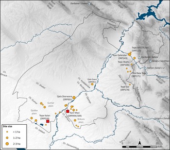
The SRP’s regional survey, which covers an area of c. 4000 sq. km along the course of the middle and lower Sirwan and its tributaries, has since 2013 identified 31 sites dating to the MB period (Glatz et al. Reference Glatz, Calderbank and Chelazzi2024, 151–80) (Fig. 2). Most of these sites are newly settled, appearing to accord with increased precipitation in the region, as demonstrated by the Kuna Ba speleothem sequence (Sinha et al. Reference Sinha, Kathayat and Weiss2019).
Map of the Sirwan Regional Project survey area, showing the location of Tepe Kalan, Kani Masi, other MB sites, and rock reliefs. (Map: Francesca Chelazzi.)
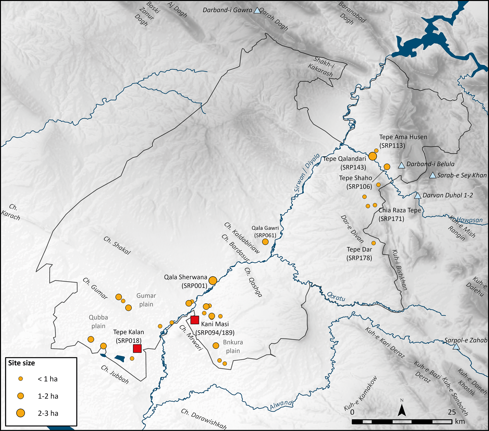
Figure 2 Long description
The map displays the Sirwan Regional Project survey area, highlighting the relative locations of Tepe Kalan, Kani Masi, and other Middle Bronze Age sites. It also marks the positions of rock reliefs. The map includes various geographic features such as rivers and plains, with site sizes indicated by different colored circles. Key locations include Tepe Kalan, Kani Masi, and other notable sites marked with specific identifiers.
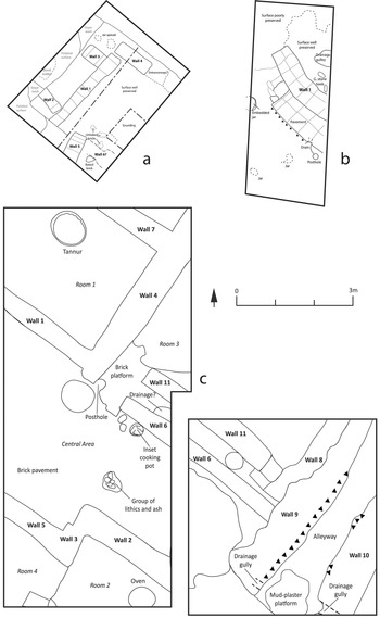
A differential settlement pattern has been observed at the line of the Gumar/Shakal and Mrwari hill-ranges, a geological bottleneck, where the Sirwan river forces its way through one of the westernmost low-lying ranges of the Zagros foothills. To the south of the Gumar/Shakal–Mrwari line, in the Qubba Plain, is a handful of larger sites, including Tepe Kalan (SRP018), which compare in size and spatial hierarchy with those in the Hamrin basin to the south. Tepe Kalan is one of the largest (c. 21 ha total), made up of a prominent 4.5 ha main mound, rising 25 m above the surrounding plain, and a sprawling lower mound to its north. Excavations in two areas of the lower mound revealed two main phases of occupation (Phases 1–2), consisting of a complex of domestic architecture and small-scale storage (Fig. 3a), as well as an outdoor multi-functional space bisected by a curved retaining wall (Calderbank et al. Reference Calderbankin review) (Fig. 3b). The 200 m separating these two excavated exposures, as well as the extensive surface spread of MB I vessel types from surface survey, speak to the significant size of Tepe Kalan during this period. Therefore, while both excavated areas represent everyday non-elite activity, it is not impossible that elite residences and institutions may also be present somewhere at the site.
Annotated plans of excavation areas at Tepe Kalan: (a) Trench A; (b) Trench B; and Kani Masi: (c) Trench K136.
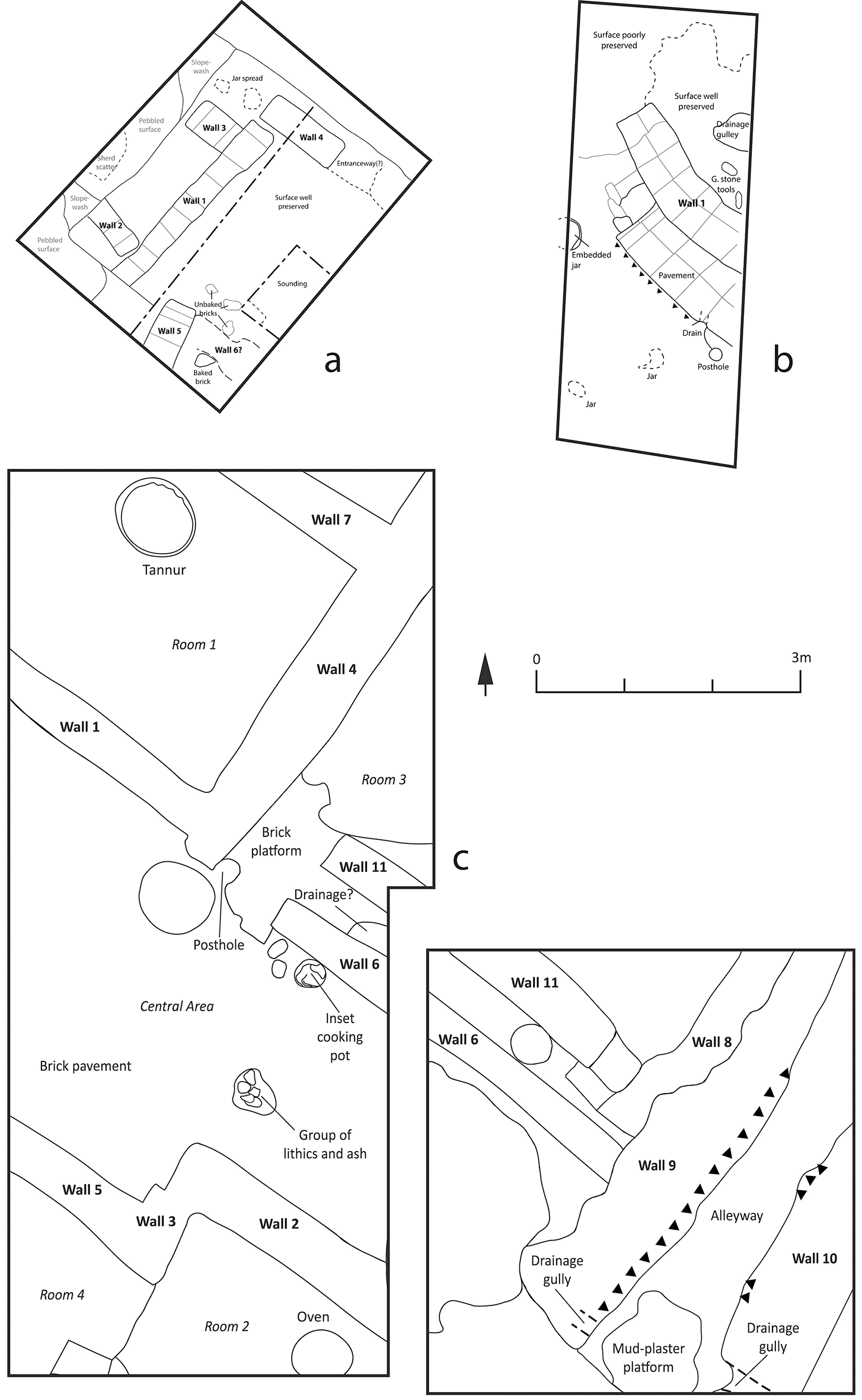
Figure 3 Long description
The image displays annotated plans of excavation areas at Tepe Kalan and Kani Masi. The plans are divided into three sections: (a) Trench A, (b) Trench B, and (c) Trench K136. Each section shows detailed layouts of walls, rooms, and various archaeological features such as postholes, drainage systems, and pavements. The plans include labels for different walls, rooms, and specific features like tannur, brick platform, and oven. The diagrams also indicate areas where surfaces are well or poorly preserved.
By contrast, the settlement pattern directly north of the Gumar/Shakal-Mrwari ranges, in the Bnkura plain, lacks clear site-size distinctions, with a scatter of small-scale agricultural settlements ranging up to 2 ha in size. One of these is Kani Masi (SRP094), part of the Kani Masi site cluster that includes the Late Bronze Age mound of the same name (SRP046).Footnote 4 Excavations at SRP094 revealed three phases (Phases 1–3) of domestic occupation, composed of several small architectural units surrounding a central space, which together produced assemblages associated closely with relatively low-status food production and consumption; an alleyway to the east was also used for material and organic discard (Glatz et al. Reference Glatz, Casana and Bendrey2019, 464–7; Reference Glatz, Calderbank and Chelazzi2024, 156–61) (Fig. 3c). An associated burial ground (SRP189), where two adult inhumations have been exposed, was also partially excavated on a low mound directly to the west (Glatz et al. Reference Glatz, Calderbank and Chelazzi2024, 161–4).
Beyond the Qubba and Bnkura plains, most sites located in the more northerly upland zones of the Sirwan, closest to the major rock reliefs of the Zagros front ranges, discussed earlier, are very small in size. Even the tallest mounds, such as Tepe Shaho (SRP106), cover only approximately 1 ha in size and there are no discernible signs of hierarchical spatial organization in the settlement record to date (Glatz et al. Reference Glatz, Calderbank and Chelazzi2024, 175–9). This suggests a very different socio-political organization to the sites of southern Mesopotamia, and encourages us to question the trust conventionally placed in lowland royal and administrative titles (for a summary of these, see e.g. Altaweel et al. Reference Altaweel, Marsh and Mühl2012, 9–11) to capture accurately the political landscapes of the uplands (Glatz et al. Reference Glatz, Calderbank and Chelazzi2024, 42, 177).
Tepe Kalan and Kani Masi: the assemblages
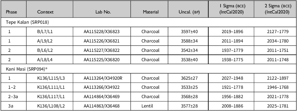
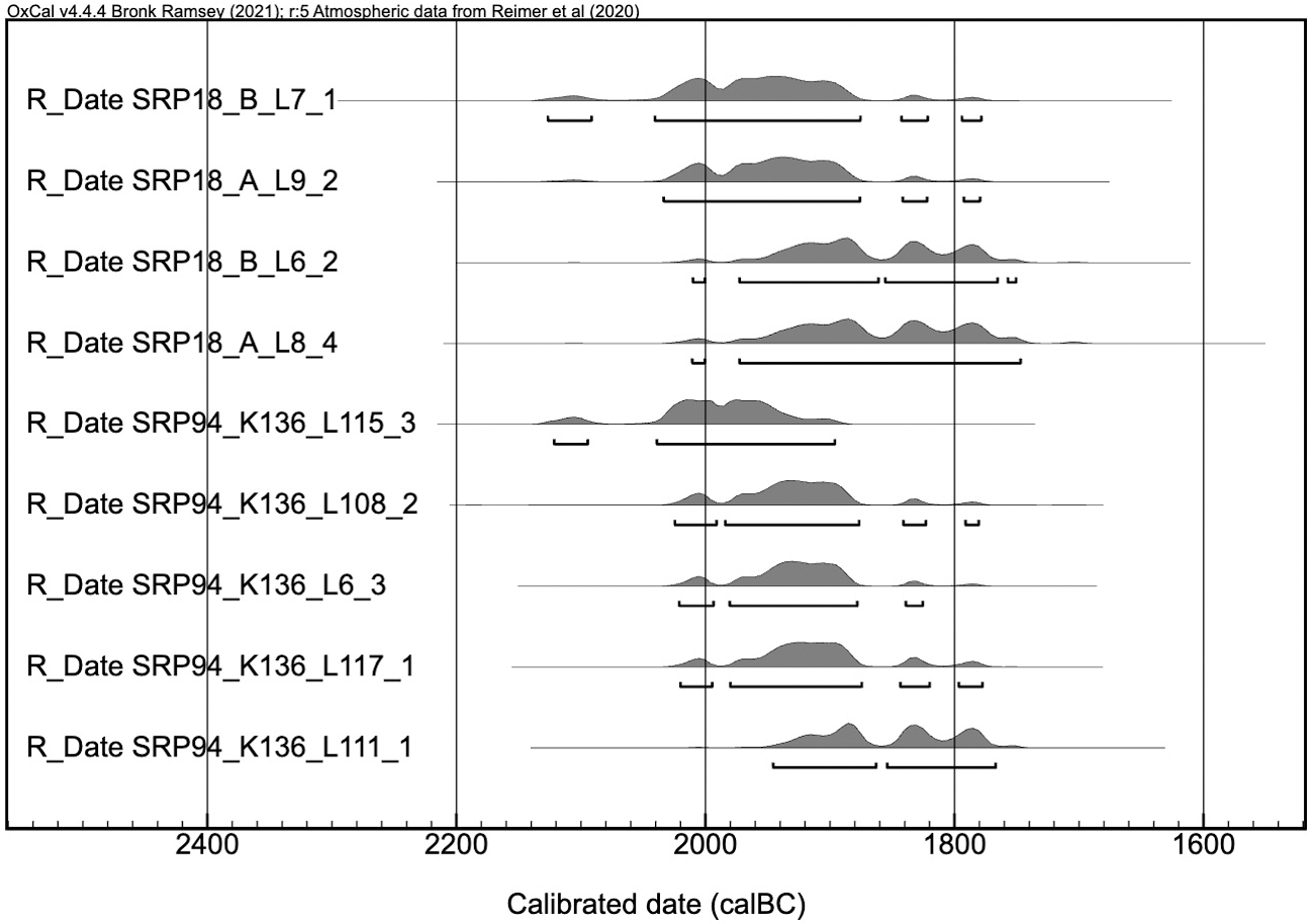
It is clear from nine radiocarbon dates—five from Kani Masi (SRP094) and four from Tepe Kalan (SRP018)—that these sites were almost certainly occupied simultaneously during the MB I, beginning sometime in the early twentieth century and continuing through to the early nineteenth century bce (Table 1; Fig. 4). Historically, this aligns with the period of localized governance and inter-city competition known further south in the Hamrin, Diyala and southern Mesopotamia, as well as with the more northerly manoeuvring of Iddi(n)-Sîn of Simurrum. Both Tepe Kalan and Kani Masi also appear to have been abandoned at approximately the same time, during the mid-nineteenth to early eighteenth century, the period during which Ešnunna’s military campaigns under Ipiq-Adad II and his successors (c. 1862–1780 bce) gathered pace, but before Ḫammurabi turned his attention to the Sirwan region (c. 1762 bce).
Phasing and associated calibrated mass spectrometry radiocarbon dates of charcoal and pulse samples from Tepe Kalan and Kani Masi.
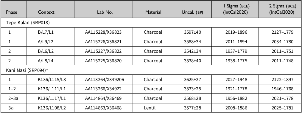
Table 1 Long description
The table presents radiocarbon dates from Tepe Kalan and Kani Masi sites, organized into phases and contexts. It includes columns for phase, context, lab number, material, uncalibrated BP, and calibrated dates at 1 and 2 sigma (BCE) using IntCal2020. The table has 9 rows and 7 columns. Row 1: Phase 1, Context B/L7/L1, Lab No. AA115228/X36823, Material Charcoal, Uncal. BP 3597±40, 1 Sigma (BCE) 2019-1896, 2 Sigma (BCE) 2127-1779. Row 2: Phase 1, Context A/L9/L2, Lab No. AA115226/X36821, Material Charcoal, Uncal. BP 3588±34, 1 Sigma (BCE) 2011-1894, 2 Sigma (BCE) 2034-1780. Row 3: Phase 2, Context B/L6/L2, Lab No. AA115227/X36822, Material Charcoal, Uncal. BP 3542±34, 1 Sigma (BCE) 1937-1779, 2 Sigma (BCE) 2011-1751. Row 4: Phase 2, Context A/L8/L4, Lab No. AA115225/X36820, Material Charcoal, Uncal. BP 3538±40, 1 Sigma (BCE) 1938-1775, 2 Sigma (BCE) 2011-1748. Row 5: Phase 1, Context K136/L115/L3, Lab No. AA113264/X34920R, Material Charcoal, Uncal. BP 3625±27, 1 Sigma (BCE) 2027-1948, 2 Sigma (BCE) 2122-1897. Row 6: Phase 1-2, Context K136/L111/L1, Lab No. AA113266/X34922, Material Charcoal, Uncal. BP 3533±25, 1 Sigma (BCE) 1921-1778, 2 Sigma (BCE) 1946-1768. Row 7: Phase 2-3a, Context K136/L117/L1, Lab No. AA114864/X36469, Material Charcoal, Uncal. BP 3568±28, 1 Sigma (BCE) 1956-1882, 2 Sigma (BCE) 2021-1778. Row 8: Phase 3a, Context K136/L108/L2, Lab No. AA114863/X36468, Material Lentil, Uncal. BP 3577±28, 1 Sigma (BCE) 2008-1886, 2 Sigma (BCE) 2025-1781.
*SRP094 dates previously published in Glatz et al. (Reference Glatz, Calderbank and Chelazzi2024, 153).
Multiplot of calibrated radiocarbon dates from Tepe Kalan and Kani Masi.
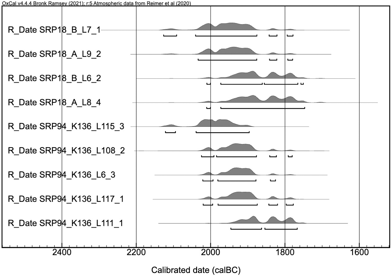
Figure 4 Long description
A line graph displays calibrated radiocarbon dates from Tepe Kalan and Kani Masi. The x-axis represents the calibrated date in calBC, ranging from 2400 to 1600. The y-axis lists different sample identifiers, including R_Date SRP18_B_L7_1, R_Date SRP18_A_L9_2, R_Date SRP18_B_L6_2, R_Date SRP18_A_L8_4, R_Date SRP94_K136_L115_3, R_Date SRP94_K136_L108_2, R_Date SRP94_K136_L6_3, R_Date SRP94_K136_L117_1, and R_Date SRP94_K136_L111_1. Each sample identifier is associated with a horizontal line and a shaded area representing the calibrated date range. The shaded areas vary in width, indicating the uncertainty or range of the calibrated dates. All values are approximated.
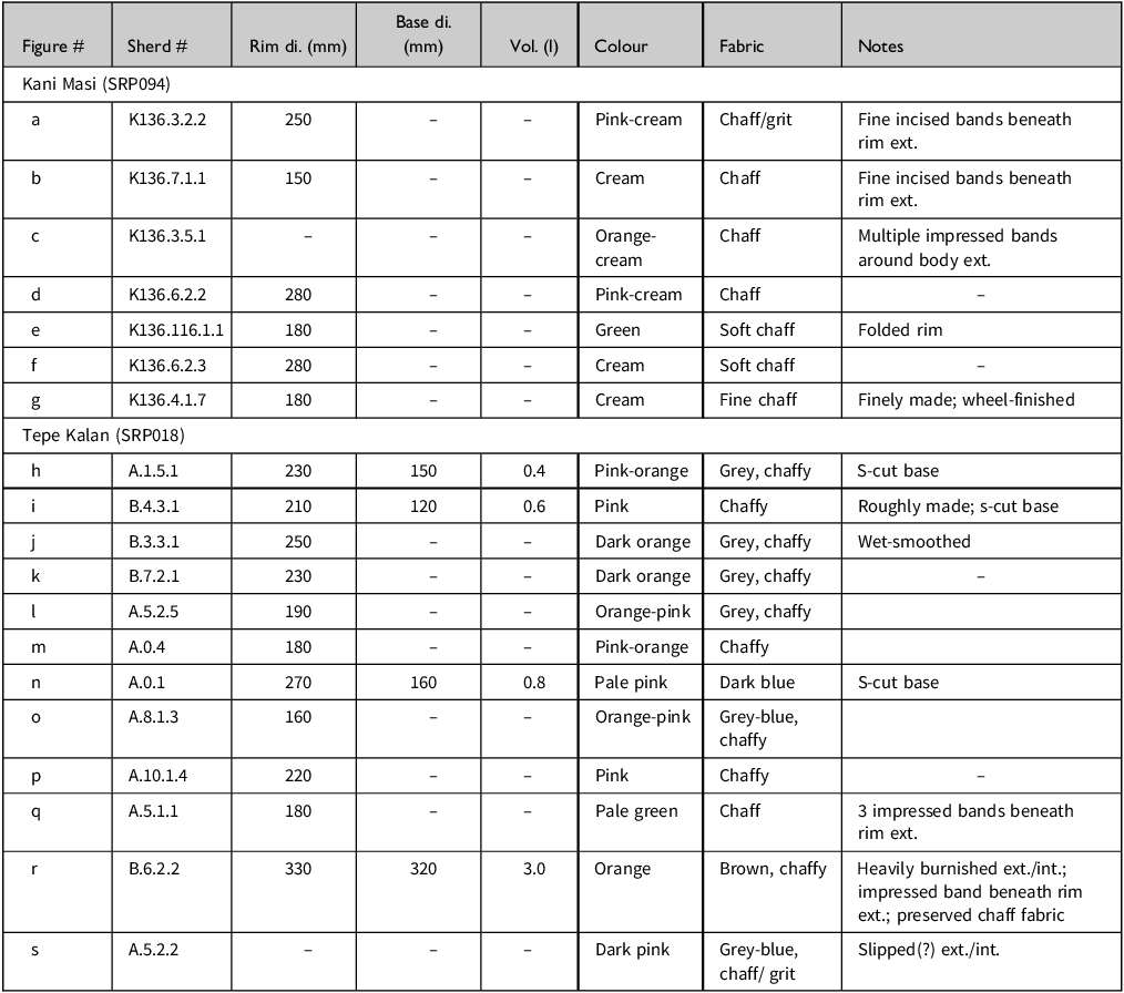
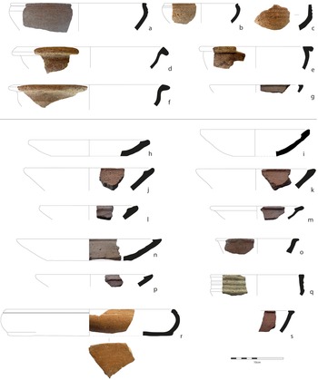
Underpinning these temporal and historical alignments at both sites are fundamental differences in their everyday material assemblages. While both sites demonstrate restricted and largely plain pottery assemblages, their styles, functionality and regional connections differ significantly. Kani Masi’s tableware assemblage consists of bowls and beakers, whose characteristics match well with types known from Late EB and MB I stratified assemblages across the wider region. Kani Masi’s bowls are varied in shape. Most common are hemispherical bowls with grooved upper bodies and simple rounded rims (Fig. 5a–c; Table 2), as well as medium-sized open bowls with ledge-rims or outwardly bevelled rims (Fig. 5d–f). Vessel sides vary, with curved, sinuous and sharply carinated examples all demonstrated. These vessels are made of various sizes, with hemispherical bowls yielding rim diameters of between 150 and 250 mm and ledge-rim/outwardly bevelled bowls slightly wider, between 180 and 280 mm. This hints at a potential functional difference between individual and communal eating, with the larger ledge-rim/outwardly bevelled bowl’s rim shapes designed for portability.
Information on sherds provided in Figure 5.
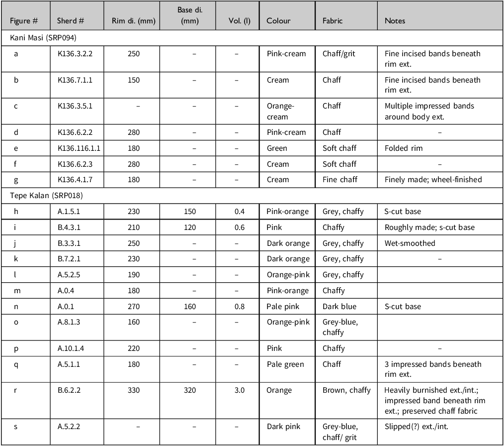
Table 2 Long description
The table compares pottery sherds from Kani Masi and Tepe Kalan sites, detailing their characteristics. It has 18 rows and 8 columns. The columns are labeled as Figure #, Sherd #, Rim di. (mm), Base di. (mm), Vol. (l), Colour, Fabric, and Notes. The rows are grouped under two headings: Kani Masi (SRP094) and Tepe Kalan (SRP018). Each row lists specific details about the sherds, including their figure number, sherd number, rim diameter, base diameter, volume, colour, fabric, and additional notes. For example, Row 1 under Kani Masi lists Figure a, Sherd K136.3.2.2, Rim di. 250 mm, Colour Pink-cream, Fabric Chaff/grit, and Notes Fine incised bands beneath rim ext.
Eating vessel types at Kani Masi (a–g) and Tepe Kalan (h–s).
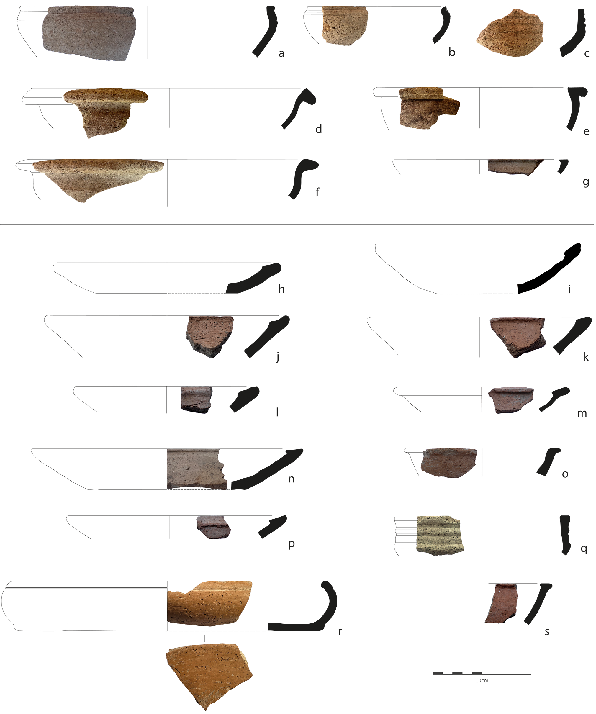
Figure 5 Long description
The image displays a variety of ancient eating vessels from two archaeological sites, Kani Masi and Tepe Kalan. Each vessel is labeled with letters from ‘a’ to ‘s’. The vessels vary in shape and size, including bowls, cups, and other ceramic containers. The image provides a comparative view of the different types of eating vessels used in these historical regions.
All bowls from Kani Masi have light pink-cream surface colours with finely cut chaff inclusions, are evenly fired and are produced by wheel-coiling, with some evidence for smoothing and finishing. Stylistically, Kani Masi’s bowls have fairly restricted parallels at Tell Yelkhi Levels 6–5 (Gabutti Reference Gabutti, Bergamini, Gabutti and Valtz2002–03, tav. 30.3–4, 34–8), Tell ed–Der (Armstrong & Gasche Reference Armstrong and Gasche2014, Family 15D, pl. 25), and Lagash (Renette Reference Renette2021, Type HF-17). Hemispherical bowls with grooved bodies and ledge-rim bowls have also been found elsewhere in the SRP survey region, at Chia Raza Tepe (SRP171), alongside a terracotta plaque with a nude goddess motif (Glatz et al. Reference Glatz, Calderbank and Chelazzi2024, fig. 15.8–15). Such plaques are typical of MB I Tell Asmar (Rossberger Reference Rossberger, Horejs, Schwall and Müller2018, 524), suggesting that at least some of Chia Raza Tepe’s inhabitants may have participated in Ešnunnan ritual or religious practices.
Just one fragmentary example of a hemispherical bowl was recovered from Tepe Kalan (Fig. 5q), found mixed in with the Phase 2 wall collapse. Dominant at Tepe Kalan instead are straight-sided bowls and platters with inwardly bevelled, usually thickened rims (Fig. 5h–n, p, and s). Vessel sides are almost always straight and flaring, but one example is vertical and incurving (Fig. 5r); bases, where preserved, are wide and flat. Platters tend to be squat in shape, with a range of rim diameters that compare well with the range also observed across Kani Masi’s types (range 180–330, avg. 231, n=10). Volumes are also varied, tending to be approximately 0.4–0.8 litres, and with one vessel reaching as much as 3 litres. Tepe Kalan’s platters find strong comparisons at Tell Yelkhi Levels 5–4 (Gabutti Reference Gabutti, Bergamini, Gabutti and Valtz2002–03, tav. 33.2 and 33.12), and at sites in the Trans-Tigris, such as Tell al-Rimah (Postgate et al. Reference Postgate, Oates and Oates1997, pls 50–51) and Kurd Qaburstan (Schwartz et al. Reference Schwartz, Creekmore, Smith, Weber and Webster2022, fig. 22.1–3). These platters were a well-integrated regional style across Babylonia too, becoming established in the northern alluvial plains in the mid-twentieth century bce, and in southern Mesopotamia seemingly only in the mid-eighteenth (Armstrong & Gasche Reference Armstrong and Gasche2014, 15–16, Family 5C & 10D, pls 3–6 & 16; Renette Reference Renette2021, 37–8, Type HB-6).
Interestingly, however, many of the platters recovered from Tepe Kalan have distinctive dark orange-pink fabrics, rough chaff and calcite inclusions and blue-grey cores indicative of low or reducing firing conditions (Fig. 5h–s; see also Calderbank et al. Reference Calderbankin review). They are hand-made and occasionally show signatures of extensive wet-smoothing, deliberate slipping, and even burnishing. This tradition of manufacture is very different to those used to produce the hemispherical and ledge-rim bowls from Kani Masi, and are instead far more typical of sites in the uplands to the north of the SRP survey area (Glatz et al. Reference Glatz, Calderbank and Chelazzi2024, fig. 5.18.26–32). An s-shaped bowl from Tepe Kalan (e.g. Fig. 5o) even demonstrates strong similarities with the broadly contemporary Shamlu ware found mainly in the Shahrizor. Just a handful of other Shamlu-style wares have been identified in the SRP survey region, at Tepe Dar (SRP178) and Tepe Shaho (SRP106) (Glatz et al. Reference Glatz, Calderbank and Chelazzi2024, 171–4). The latter site, which also has large platters of a similar style to Tepe Kalan (Glatz et al. Reference Glatz, Calderbank and Chelazzi2024, fig. 5.18.31), produced in local fabrics and by local techniques, is located in the centre of the Hawasan valley, midway between the Sirwan river and the Darband-i Belula ravine.
A single sherd of an in-turned bowl, similar to those from Tepe Kalan, was found at Kani Masi (Fig. 5g), recovered from the accumulated alleyway of Phases 2–3, a place of waste deposition associated with episodic, and perhaps sometimes inter-community, feasting (Glatz et al. Reference Glatz, Calderbank and Chelazzi2024, 156). The cream, fine-ware production of this vessel, however, is again very different to the manufacturing techniques used to produce these shapes at Tepe Kalan, therefore further accentuating the differences between the Kani Masi and Tepe Kalan tableware assemblages.
These stylistic inconsistencies point towards different dominant food cultures at Kani Masi and Tepe Kalan. The flat, open shapes of Tepe Kalan’s platters, often with stable bases, would have rendered them awkward to handle. This meant that these vessels would probably have been static during use, but that their contents were highly visible and easily accessible, with the shape well suited for holding bread or perhaps larger cuts of meat. Hemispherical and ledge-rim bowls, on the other hand, with their rounded bases, are less stable and seem instead designed to be held individually or passed around. These vessels are probably more suited to stews or broths, of the kind outlined in the broadly contemporary Yale Culinary Tablets (Bottéro Reference Bottéro2004). These different food habits may have contributed to the negotiation of power relations; responsibility for the carving of meat for instance, may have formed an expression of social hierarchy, while the sharing of meals in large bowls can embed aspects of social solidarity (Robin Reference Robin2020, 379).
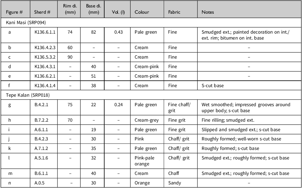
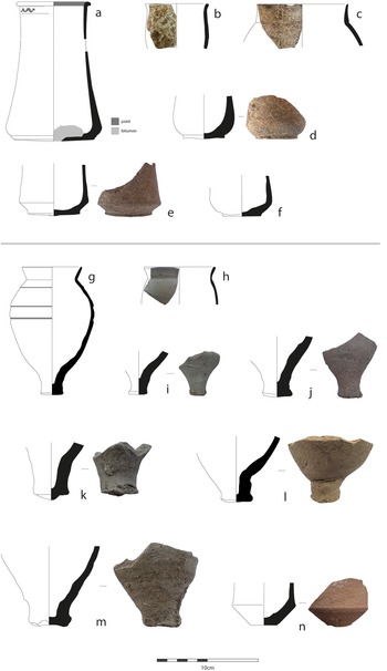
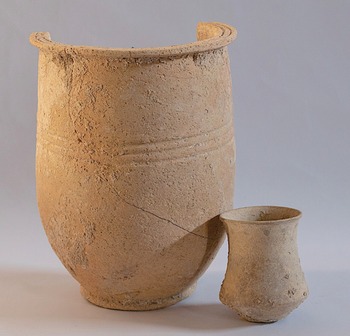
Drinking vessels at both sites demonstrate similarly complex patterns of stylistic overlap and difference. Present in significant numbers at Kani Masi are cylindrical beakers, with open mouths, concave-vertical sides and sharp carinations on the lower body directly above flat or slightly convex bases (Fig. 6a–b, d–f; Table 3). These are present at Kani Masi in a range of sizes; smaller versions are more numerous and finely made, with round or slightly thickened rims that sometimes exhibit a black painted band on the interior and/or exterior (e.g. Fig. 6a). A single volume has been measured for a small beaker of approximately 0.4 litres (Fig. 6a). Larger examples are also present in smaller numbers; these beakers have wide, flat ledge rims, usually with incised grooves, as well as grooved or impressed decoration around the body. One such vessel from a burial at Kani Masi (SRP189) has a capacity of approximately 3.6 litres (Fig. 7).
Information on sherds provided in Figure 6.
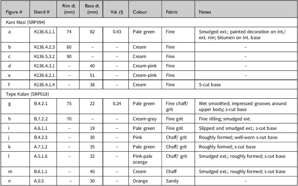
Table 3 Long description
The table presents detailed information about sherds from Kani Masi and Tepe Kalan. It includes columns for Figure number, Sherd number, Rim diameter, Base diameter, Volume, Colour, Fabric, and Notes. The table has 14 rows and 8 columns. Row 1: Figure a, Sherd K136.6.1.1, Rim di. 74 mm, Base di. 82 mm, Vol. 0.43 l, Colour Pale green, Fabric Fine, Notes Smudged ext.; painted decoration on int./ext. rim; bitumen on int. base. Row 2: Figure b, Sherd K136.4.2.3, Rim di. 60 mm, Base di. not provided, Vol. not provided, Colour Cream, Fabric Fine, Notes not provided. Row 3: Figure c, Sherd K136.5.3.2, Rim di. 90 mm, Base di. not provided, Vol. not provided, Colour Cream, Fabric Fine, Notes not provided. Row 4: Figure d, Sherd K136.4.3.1, Rim di. not provided, Base di. 40 mm, Vol. not provided, Colour Cream-pink, Fabric Fine, Notes not provided. Row 5: Figure e, Sherd K136.6.2.1, Rim di. not provided, Base di. 51 mm, Vol. not provided, Colour Cream-pink, Fabric Fine, Notes not provided. Row 6: Figure f, Sherd K136.4.1.4, Rim di. not provided, Base di. 38 mm, Vol. not provided, Colour Cream, Fabric Fine, Notes S-cut base. Row 7: Figure g, Sherd B.4.2.1, Rim di. 75 mm, Base di. 22 mm, Vol. 0.24 l, Colour Pale green, Fabric Fine chaff/grit, Notes Wet smoothed; impressed grooves around upper body; s-cut base. Row 8: Figure h, Sherd B.7.2.2, Rim di. 70 mm, Base di. not provided, Vol. not provided, Colour Cream-grey, Fabric Fine grit, Notes Fine rilling; smudged ext. Row 9: Figure i, Sherd A.6.1.1, Rim di. not provided, Base di. 19 mm, Vol. not provided, Colour Pale green, Fabric Fine grit, Notes Slipped and smudged ext.; s-cut base. Row 10: Figure j, Sherd B.4.2.3, Rim di. not provided, Base di. 30 mm, Vol. not provided, Colour Pink, Fabric Chaff/grit, Notes Roughly formed; well-worn s-cut base. Row 11: Figure k, Sherd A.7.1.2, Rim di. not provided, Base di. 35 mm, Vol. not provided, Colour Pale green, Fabric Chaff/grit, Notes Roughly formed; s-cut base. Row 12: Figure l, Sherd A.5.1.6, Rim di. not provided, Base di. 32 mm, Vol. not provided, Colour Pink-pale orange, Fabric Chaff/grit, Notes Smudged ext.; roughly formed; s-cut base. Row 13: Figure m, Sherd B.6.1.1, Rim di. not provided, Base di. 40 mm, Vol. not provided, Colour Cream, Fabric Chaff, Notes Smudged ext.; roughly formed; s-cut base. Row 14: Figure n, Sherd A.0.5, Rim di. not provided, Base di. 30 mm, Vol. not provided, Colour Orange, Fabric Sandy, Notes not provided.
Drinking vessel types at Kani Masi (a–f) and Tepe Kalan (g–n).
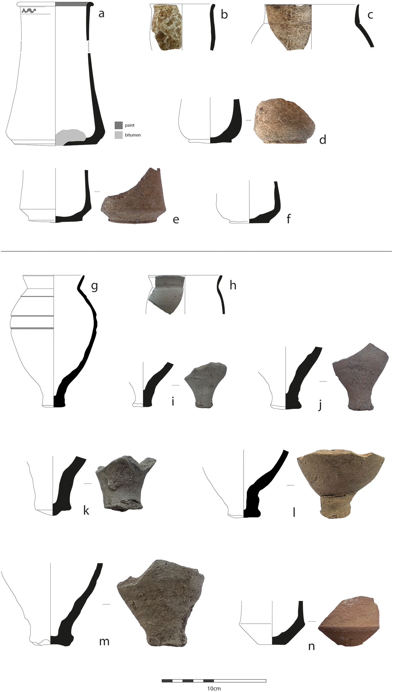
Figure 6 Long description
The illustration presents various types of drinking vessels discovered at the archaeological sites of Kani Masi and Tepe Kalan. The vessels are depicted in different shapes and fragments, with detailed annotations highlighting specific features such as paint and bitumen. Each vessel type is labeled with letters from ‘a’ to ‘n’, indicating distinct forms and styles. The illustration includes side views and cross-sections to provide a comprehensive understanding of the vessel structures. The vessels from Kani Masi are labeled ‘a’ to ‘’, while those from Tepe Kalan are labeled ‘g’ to ‘n’. The annotations specify areas with paint and bitumen, offering insights into the materials and construction techniques used in ancient times.‘, ’EDH‘: ’Drinking vessel types at Kani Masi (a–f) and Tepe Kalan (g–n)
Beakers from Burial SRP189.1.
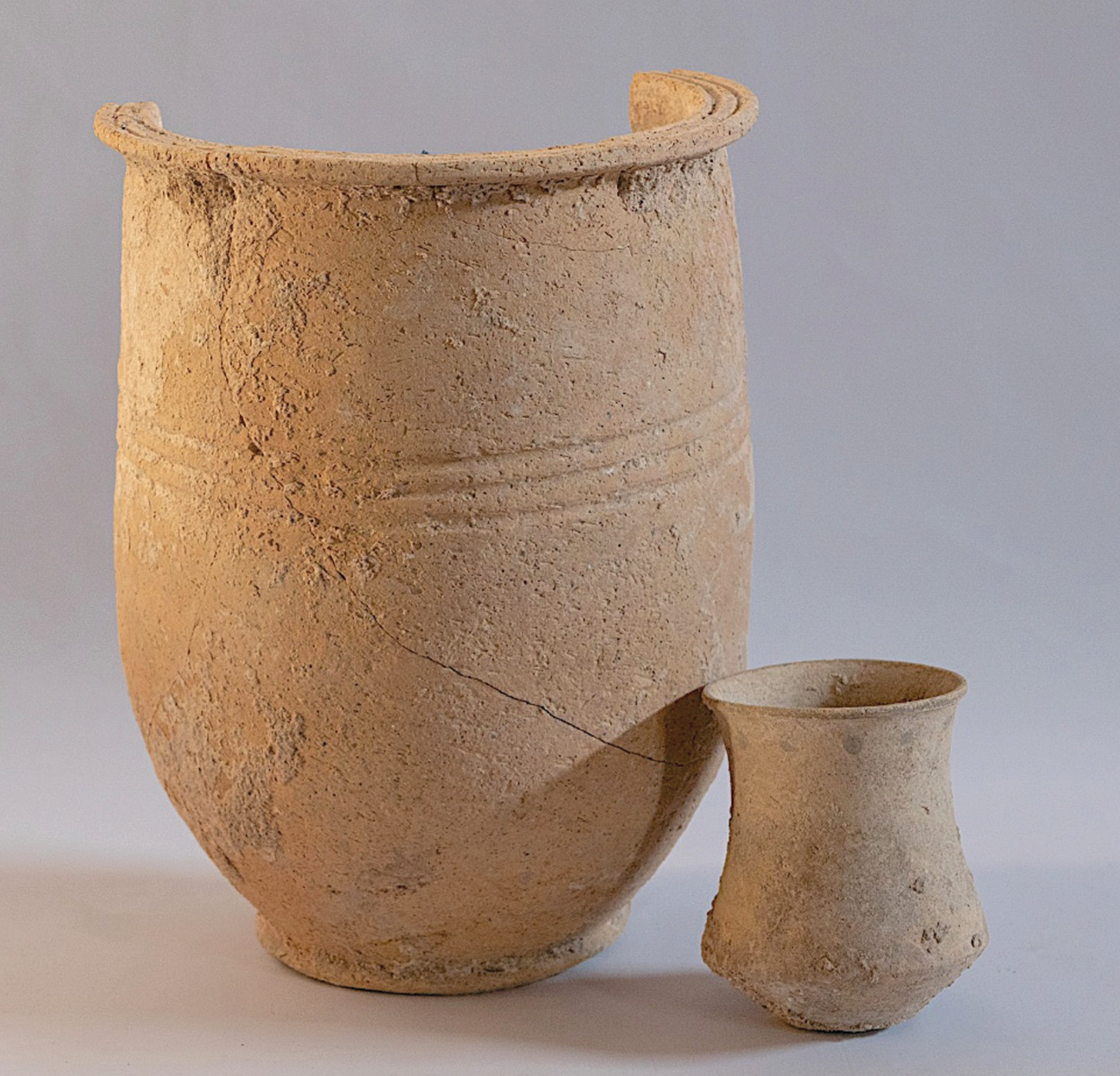
These variously sized beakers perhaps formed part of a drinking set, and are attested in domestic and funerary contexts, where they often appear in connection with larger straight-sided or narrow-necked jars (Glatz Reference Glatz, Glatz, Palmero Fernández, Richardson and Seymour2025); corroboratory sets have previously been identified in the Hamrin, at Tell Halawa (Yaseen Reference Yaseen1995, pl. 59–63, painted examples: pl. 62.44 and 62.48), Tell Yelkhi (Gabutti Reference Gabutti, Bergamini, Gabutti and Valtz2002–03, tav. 60–62 and 70), Tell Ahmed al-Mughir (Gibson Reference Gibson1981, 152–3), and the Diyala region, at Tell Asmar and Ischali (Delougaz Reference Delougaz1952, 120, pl. 153), as well as at Kish (Langdon Reference Langdon1924, pl. 32). That a particularly fine small beaker (volume: 0.18 litre) with painted dots located beneath the rim was deposited in Burial 189.1 at Kani Masi, placed inside a larger beaker with grooved ledge-rim (Fig. 7), further emphasizes the functional and symbolic associations between these vessels and their centrality to processes of identity creation. Individual examples of these vessels have been found further north in the SRP survey region, at Qala Gawri (SRP061) (Glatz et al. Reference Glatz, Calderbank and Chelazzi2024, fig. 5.18.1).
Metal versions of these distinctive beakers have also been found in MB graves in Lurestan (Begemann et al. Reference Begemann, Haerinck, Overlaet, Schmitt-Strecker and Tallon2008; Schmidt et al. Reference Schmidt, van Loon and Curvers1989, pls 124, 126–7), and at Godin Tepe (Henrickson Reference Henrickson, Gopnik and Rothman2011, fig. 6.16). Cylindrical beakers of various sizes and typical hemispherical bowls of precisely the same shapes found at Kani Masi were also produced at Godin Tepe (Phase III:2; c. 1900–1600 bce) of a local burnished grey ware, perhaps designed to imitate metals (Henrickson Reference Henrickson, Gopnik and Rothman2011, fig. 6.48). This evidence strongly points towards shared commensal practices between the transitional community of Kani Masi and surrounding highland communities, replicated in a range of materialities (see also Glatz Reference Glatz, Glatz, Palmero Fernández, Richardson and Seymour2025).
Such beakers show a far more mixed distribution in the lowland alluvial plains (Armstrong & Gasche Reference Armstrong and Gasche2014, Group 65, pls 52–54). According to Armstrong and Gasche (Reference Armstrong and Gasche2014, 34–5), these vessels probably entered northern Babylonia from the Sirwan river valley in the early nineteenth century, with examples recovered at Tell ed-Der, but only became established in southern Babylonia later in the mid-eighteenth century, at Nippur, Larsa and Uruk. Interestingly, some of the southern examples, including a vessel from Nippur (Armstrong & Gasche Reference Armstrong and Gasche2014, pl. 54.6), also exhibit a band of dark paint around the rim, the same as those from Kani Masi, albeit of a significantly later date.
These beaker shapes were not identified from stratified assemblages at Tepe Kalan, and only one example was recovered from extensive surface collections of the lower mound (Fig. 6n). Tepe Kalan’s drinking assemblage instead comprised small, closed cups. These cups have simple rounded rims, short defined necks, round-to-ovoid bodies and narrow stump feet (Fig. 6g–m). Similar vessels are known from Bakr Awa (Miglus et al. Reference Miglus, Bürger, Fetner, Mühl and Sollee2013, fig. 14a), Tell Yelkhi Levels 4–3 (Gabutti Reference Gabutti, Bergamini, Gabutti and Valtz2002–03, tav. 67–69.1–6), Tell Halawa (Yaseen Reference Yaseen1995, pl. 130-4), Tell Asmar, Ischali (Delougaz Reference Delougaz1952, pls 151 and 170) and Kurd Qaburstan (Schwartz et al. Reference Schwartz, Creekmore, Smith, Weber and Webster2022, 11, fig. 10.3). They are also very common at sites across the northern alluvial plains, and as far west along the Euphrates as Harrâdum, but only from the late nineteenth century onwards, as well as at Nippur and Isin in the mid-eighteenth (Armstrong & Gasche Reference Armstrong and Gasche2014, Group 170A, pl. 85). Just one probable neck and rim sherd of such a closed cup was found at Kani Masi Phase 3a (Fig. 6c), while further isolated examples have been recovered from SRP071, also in the Bnkura plain, and SRP113 in the upland terraces (Glatz et al. Reference Glatz, Calderbank and Chelazzi2024, figs 5.17.20 and 5.18.36).
Cups at Tepe Kalan have been recovered in two main sizes: small and unstable, with foot diameters tightly clustering around 20 mm (18–22 mm), and larger more stable examples with foot diameters of 30–40 mm. Rim diameters, where preserved, are 70–75 mm, while one volume of 0.24 litre is recorded for a smaller cup (Fig. 6g). While the larger variety tend to be quite roughly produced and finished, some the smaller vessels are finely produced and relatively carefully finished, with incised/impressed grooves positioned around the shoulder. Regardless of the quality of production, cups were built using the wheel-coiling technique, in traditional second-millennium bce style (e.g. Bürger Reference Bürger, Miglus and Mühl2011; Calderbank Reference Calderbank2021, 51–3). Vessel surfaces regularly demonstrate heavy wet-smoothing and smudging, typical of the combination of water with manual pressure to join coils. Feet are invariably string cut. Unlike Tepe Kalan’s bowls, the cups are produced almost exclusively of pale green-cream and evenly fired fabrics, thus indicating a divergent chaîne opératoire between these vessel families.
The stylistic differences between Kani Masi’s beakers and Tepe Kalan’s cups also assume performative significance. Both beakers and cups, where we can measure, seem to have fairly similar sizes and capacities (Table 3). Beakers, however, have an open shape, meaning that their contents would have been visible during consumption activities. Cups, on the other hand, have restricted necks, therefore concealing the contents and minimizing spillage. Furthermore, the instability of cups due to their narrow feet means that these vessels must have been held in the hand until the contents were drained, thus requiring either the quick consumption of drinks or else the passing of these vessels between individuals within a group.
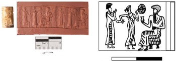
This practice echoes prevalent contemporary imagery circulating in the late third and early second millennium bce across Mesopotamia. The so-called ‘presentation scene’ on cylinder seals depicts a seated divinity or king holding a cup outstretched in one hand; before him stands a supplicant alongside an interceding goddess (Zajdowski Reference Zajdowski2013). The ubiquitous presence of the drinking vessel in these scenes is notable, and suggests that, when a vassal visited their sovereign, they were invited to drink, with this recursive gesture forming a core part of the physical language of political power (Michalowski Reference Michalowski and Milano1994, 36–7). These images increased dramatically in popularity at Ešnunna during the early second millennium bce (e.g. Al-Luhaibi Reference Al-Luhaibi2023), with similar cylinder seal iconography also being used to depict Iddi(n)-Sîn (Shaffer et al. Reference Shaffer, Wasserman and Seidl2003, 31–5, figs 4–5). While the vessels depicted tend to be highly stylized, they almost invariably have flaring necks, far more in line with Tepe Kalan’s cups than Kani Masi’s beakers (Fig. 8).
Cylinder seal with presentation scene from Tell Asmar (IM 192665) (Al-Luhaibi Reference Al-Luhaibi2023, fig. 16).
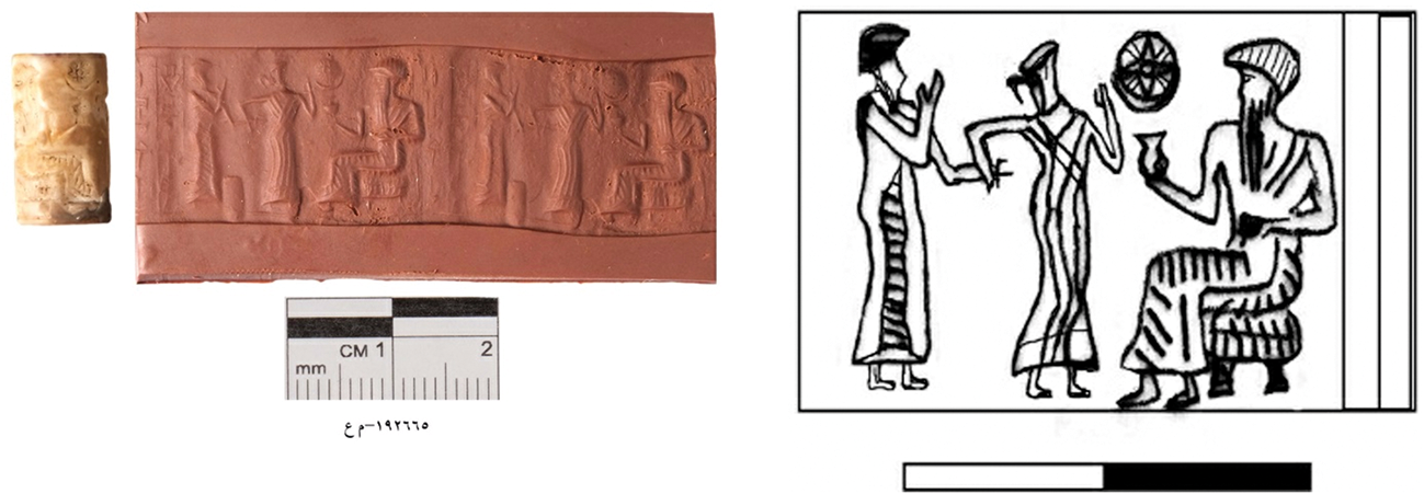
Figure 8 Long description
The image shows a cylinder seal with a detailed presentation scene from Tell Asmar. The seal features three figures: one seated figure in the center, flanked by two standing figures. The standing figure on the left is holding an object towards the seated figure, while the standing figure on the right is holding a circular object. The scene is intricately carved, showcasing the craftsmanship of the period. The seal is accompanied by a measurement scale indicating its size, with a length of approximately two centimeters.
Practised borderities in the Zagros Piedmont
A series of letters between Aradmu, an official of the royal court of Ur, and king Shulgi (2094–2046 bce) reveal the multiplicity of Middle Bronze Age borderland dynamics in the lands of Subir.Footnote 5 For example:
You have commissioned me to keep in good condition the expedition roads to the land of Subir, to stabilize the borders of your country, to make known the ways of the country.Footnote 6 (ArŠ1, trans. Kramer Reference Kramer1963, 331)
We see in these letters the ways in which semi-fixed built infrastructure, such as roads and earthworks, came together with values, customs and traditions, as well as displays of royal patronage, to construct ideational top-down geographies of power. Underlying this, we might also recognize the power of everyday actions—the ways of the country—in shaping political spatialities (e.g. Bauer & Kosiba Reference Bauer and Kosiba2016; Robin Reference Robin2020), as well as a consequent desire to impose standardized behaviours and, importantly, a tacit acceptance that these everyday encounters were not entirely within royal control (see Michalowski Reference Michalowski2011, 75, for similar arguments).
It is these points of encounter, negotiated through the material world, that archaeologists are uniquely positioned to identify. Yet archaeological practice has long been employed in the service of text-derived geographies of power, seeking to confirm the spatial and temporal reach of the state. The vibrant MB rock reliefs of the Zagros front ranges have been discussed almost entirely through the prism of state territorialities, interpreted as marking the extent of the military campaigns of Simurrum and thus delimiting its territorial borders (Alibaigi et al. Reference Alibaigi, Aliyari, MacGinnis and Aminikhah2020; Altaweel et al. Reference Altaweel, Marsh and Mühl2012, 11). We instead argue that these landscape monuments were a multi-locational network of curated borderities, that is spatially distributed materializations of ongoing multi-directional power dynamics by which individual rulers and/or subversive groups attempted to incorporate complex landscapes and their diverse inhabitants (e.g. Glatz Reference Glatz and Osborne2014; Reference Glatz2020, 152–74 for discussion of Hittite landscape monuments). Since rock reliefs were, by their nature, dependent on material affordances, such as the demands of a relatively flat workable rock face, their location must to an extent have been opportunistic; these were some of the only places in the region that they could have been carved. Rock reliefs and worked stele were therefore not the ‘jacket of territory’ but were ‘one of multiple knots in a complex weaving’ (after Amilhat Szary & Giraut Reference Amilhat Szary and Giraut2015, 9).
Pottery vessels formed another of these archaeologically identifiable ‘knots’. The production and consumption practices surrounding MB pottery provided regular arenas for the performance of identity and the consequent emergence of situated borderities. Close object-oriented analysis of the excavated pottery from non-elite contexts at Tepe Kalan and Kani Masi, located near to one another in the shadows of the contemporary rock reliefs, have identified assemblages that, while internally consistent, are stylistically very different from one another; local differences in commensal practice and sociality that go hand-in-hand with divergent settlement behaviours that suggest discrete forms of social organization (Glatz et al. Reference Glatz, Calderbank and Chelazzi2024, 176–7, 369–70).
A traditional political-typological approach, in the absence of radiocarbon dates, might interpret these differences as markers of a chronological and/or political transition between an ‘Isin-Larsa’ assemblage (c. 2004–1790 bce), characterized by cylindrical beakers with open mouths at Kani Masi, and an ‘Old Babylonian’ assemblage (c. 1790–1595 bce), typified by closed cups with flaring necks at Tepe Kalan. The tight alignment of radiocarbon dates from the two excavated sites, however, coupled with the infrequent presence of distinctive crossover vessel types, establishes the contemporaneity of these two communities during the MB I (c. 2000–1850 bce). A second traditional avenue of interpretation might therefore be spatial, with the material differences representing an imperial border fixed at the Sirwan river and/or at the line of the low-lying Gumar/Shakal-Mrwari ranges, separating the state-driven urban expansion of Ešnunna at Tepe Kalan (21 ha) from the non-state rural conservatism of Kani Masi (2 ha) to its northeast (for urban–rural critique, see Van Oyen Reference van Oyen2019). While we are dealing with settlements of different scales, the excavated evidence suggests communities of a comparative non-elite social status and inter-regional connectivity.
It is therefore clear that none of the above interpretations plausibly account for the patterns presented in this paper. Instead, the data from these two sites highlights the limitations of traditional archaeological modes of analysis, which draw neat binary patterns from empirical messiness and, in so doing, exaggerate asymmetries of power and close down localized complexity (see Pollock Reference Pollock, Bernbeck and McGuire2011 for similar arguments). Both Tepe Kalan and Kani Masi demonstrate extended, albeit divergent, inter-regional networks (Fig. 9). Kani Masi’s beakers and bowls show strong links with sites in the Hamrin and Diyala regions, as well as clear eastward connections stretching into the Zagros, where similarly shaped vessels were produced in metals and in distinctive localized grey wares (Glatz Reference Glatz, Glatz, Palmero Fernández, Richardson and Seymour2025). At Kani Masi, however, these vessels were produced by typical Babylonian techniques (van As & Jacobs Reference van As, Jacobs, Armstrong and Gasche2014), with strong internal consistency in colour and fabric composition. The care shown for these vessels is testified by the comparatively fine wares of almost all beakers, while their centrality to community identity is attested by their inclusion in burials at the adjacent funerary mound (SRP189).
Network map of sites sharing eating and drinking vessels of Tepe Kalan, Kani Masi and localized styles. (Map: Francesca Chelazzi.)
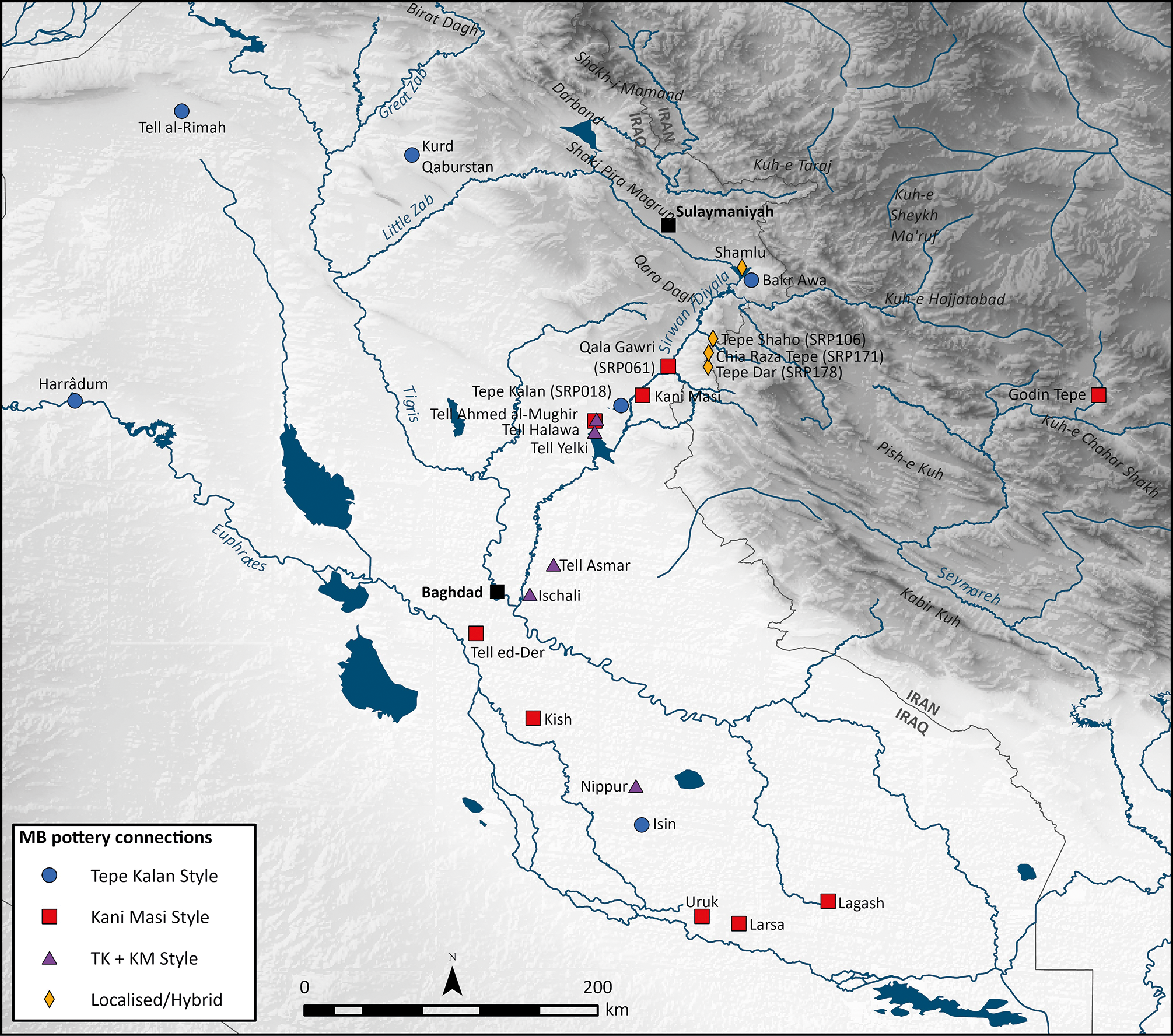
Figure 9 Long description
The map illustrates the Zagros piedmont zone, highlighting various mountain ranges, passes, intermontane plains, and river valleys. It marks ancient political entities such as Ur III, Enunna, Simurrum, Lullubum, and Gutium. The Sirwan river valley is prominently featured, indicating its historical significance. The map also shows sites sharing eating and drinking vessels of Tepe Kalan, Kani Masi, and localized styles, with different symbols representing these styles. Key locations include Tell al-Rimah, Kurd Qaburstan, Sulaymaniyah, Tepe Kalan, Kani Masi, Tell Asmar, Baghdad, Tell ed-Der, Kish, Nippur, Isin, Uruk, Lagash, Larsa, and Godin Tepe.
Tepe Kalan’s assemblage, on the other hand, was composed of two main commensal vessel types: stump-footed cups and platters. Both were common shapes in the Hamrin and Diyala region and were apparently introduced into the assemblages of the northern alluvial plains during the nineteenth century bce (Armstrong & Gasche Reference Armstrong and Gasche2014, 15–16, 53–4, Groups 5C, 10D and 170A–B). These two vessel families differ in their technological traditions. Cups were produced by typical Babylonian wheel-coiling techniques (Calderbank Reference Calderbank2021, 51–3); some were skilfully manufactured, with fine fabrics and carefully finished and slipped surfaces, while others were roughly manufactured and finished, suggesting diverse origins of production, with some perhaps arriving at the site from elsewhere.
Cups appear to have been integrated within a set of formalized drinking practices that had taken hold across the region, best demonstrated in elite iconography emanating from Ešnunna. Tepe Kalan’s community evidently bought into these emergent drinking customs. Tepe Kalan’s platters, on the other hand, were handmade of localized red-orange fabrics, more typical of those identified at surveyed sites in the upland terraces, closer to the monumental rock reliefs, which share technological similarities with the distinctive Shamlu tradition of the Shahrizor (Mühl Reference Mühl, Hofmann, Moetz and Müller2012, 89–90).
It is worth briefly reflecting on the social identities and organization of the communities of pottery producers servicing Tepe Kalan and Kani Masi. While it is generally accepted that MB I potters held a low social status (e.g. Wright Reference Wright, Costin and Wright1998), the nature of potting activities and their relationship with centralized institutions—as attached or independent specialists (after Brumfiel & Earle Reference Brumfiel, Earle, Brumfiel and Earle1987; Stein Reference Stein and Wailes1996), for example—is a subject of ongoing debate. Pottery, despite its archaeological abundance, is rarely mentioned in texts. Consequently, a small group of Ur III texts (c. 2050 bce), which tally a significant amount of labour still owed to the state apparatus of Umma from the previous year by two pottery workshops—totalling the equivalent of 33 workers operating for an entire year—have received excessive attention (Dahl Reference Dahl, Koslova, Loesov, Kogan and Tishcenko2010; Sallaberger Reference Sallaberger1996, 35; Steinkeller Reference Steinkeller1996; Waetzoldt Reference Waetzoldt1970/71). Two points in particular have been taken from these texts: firstly, that they testify to the scale of production at these pottery workshops; secondly, that this evidence alongside Old Babylonian (van de Mieroop Reference van de Mieroop1992, 104), Kassite (Sassmanhausen Reference Sassmanhausen2001, 96–7) and Middle Assyrian (Jakob Reference Jakob2003) ration lists suggests that Mesopotamian potters enjoyed the status of fully-fledged state dependents servicing elite institutions.
Yet this apparent dependency of potters on the central state serves to mask the everyday actions and interactions between potters and other craftspeople, known from various administrative texts, which assumed a much more independent form. We know, for example, that potters gathered their own raw materials (Steinkeller Reference Steinkeller1996, 242), passed their vessels to other specialists—brewers, millers, and oil pressers—to be filled with their respective products, and acquired various types of leather, hide and rope/cord for wrapping both empty and full vessels (Sallaberger Reference Sallaberger1996, 18–22; van de Mieroop Reference van de Mieroop1987, 38). This organization, Steinkeller (Reference Steinkeller1996, 251) refers to as ‘indirect oversight’ (for criticism, see Dahl Reference Dahl, Koslova, Loesov, Kogan and Tishcenko2010). And this is, of course, not taking into account the likely vast majority of entirely decentralized potting activities that left no textual record. A full picture of exactly how the potters of Tepe Kalan and Kani Masi were organized cannot be developed from the evidence presented here. Nevertheless, the diversity of co-existing technological traditions, within and between these sites, as well as variation in the care and skill of forming and finishing between individual vessels of the same shape type, strongly points towards decentralized and diverse communities of craft practice.
It seems implausible that the communities of Tepe Kalan and Kani Masi would not have been well aware of each other’s material and cultural practices. The conscious and repeated decisions not to integrate within the same technological and commensal networks are where borderities, those community relations and segmentations present psychologically, became materialized through the taskscape, the sum total of practices and actions performed by the inhabitants of the two sites, which in turn shaped their physical and conceptual landscapes (after Ingold Reference Ingold2000, 196). Curiously, the material differences between these two sites also endures through time. Once both sites were resettled several hundred years later in the latter half of the second millennium bce, while Tepe Kalan’s pottery assemblage demonstrates a meeting of Late Bronze Age cultural influences, with a mixture of Kassite- and Middle Assyrian-style wares (Calderbank et al. Reference Calderbankin review), Kani Masi’s (SRP046) assemblage was remarkably homogenous, with almost no pottery types beyond its limited Kassite-style repertoire (Glatz et al. Reference Glatz, Calderbank and Chelazzi2024, 272–4).
Similarly complex relationships were at play along the length of the Sirwan river valley. Looking to the Shahrizor plain, the sites of Bakr Awa and Gird-i Shamlu, located just 10 km apart, demonstrate starkly divergent Babylonian- and Shamlu-style pottery traditions (e.g. Al-Husaini Reference Al-Husaini1962; Al-Janabi Reference Al-Janabi1961). Furthermore, the surface assemblages from sites in the upland terraces of the Sirwan—Tepe Shaho (SRP106) and Chia Raza Tepe (SRP171)—exhibit mixed, hybrid materialities. Here, Babylonian-style shapes produced using hand-made, chaff-tempered and slipped/burnished wares of a local style, sit alongside more straightforwardly Babylonian-style cups and bowls, as well as lowland-style figurative art (Glatz et al. Reference Glatz, Calderbank and Chelazzi2024, 171–4). Further south in the Hamrin, Tell Yelkhi has yielded vessels of both the Kani Masi and Tepe Kalan types merged within its Level 6–3 assemblages (Gabutti Reference Gabutti, Bergamini, Gabutti and Valtz2002–03; Oselini Reference Oselini, D’Andrea, Micale, Nadali, Pizzimenti and Vacca2019), a complex assemblage which has puzzled researchers of Mesopotamian pottery (e.g. Armstrong & Gasche Reference Armstrong and Gasche2014, 11–12). These complicated connections and divergences are typical of multi-layered borderities, both between and within communities occupying the same landscapes.
Conclusions
The Sirwan river traverses multiple contemporary borders as it meanders from its source in the Zagros highlands in Iran through the intermontane plains of the Kurdistan Region of Iraq, to reach its confluence with the Tigris in Iraq. Like many of the landscapes of Southwest Asia, this region has been deeply incised by colonial lines-on-a-map approaches to national borders (Jüde Reference Jüde2017; Khalidi Reference Khalidi2016). Geopolitically charged public-facing bordering and de-bordering agendas have long been common across the region, into which the archaeological record has inevitably, selectively and uncritically been drawn, with interpretations seeking to align historical geographies with these modern boundaries. These practices fall into the tautological trap that Roderick Campbell (Reference Campbell, D’Alfonso and Rubinson2021, 38) articulately summarizes: ‘the spatial imaginations of nation-state dwellers project lines onto maps of ancient polities and then go looking for them in texts, potsherds and monuments’.
Contemporary critical border studies have confronted these normative approaches to state territorialities, conceiving of modern borders as mobile and continually emergent rather than fixed, physical and enduring. Amilhat Szary (Reference Amilhat Szary2023, 1026) has recently challenged archaeologists to ‘read the past in search of complex definitions of limits and interfaces’. A raft of scholars, drawing on archaeological contexts spanning the globe, have already taken up this challenge (e.g. Campbell Reference Campbell, D’Alfonso and Rubinson2021; Frangipane Reference Frangipane, D’Alfonso and Rubinson2021; Glatz Reference Glatz2020; Grosby Reference Grosby and Snell2020, 235–8; Langer & Fernández-Götz Reference Langer and Fernández-Götz2020; Lightfoot & Martinez Reference Lightfoot and Martinez1995; McCarthy Reference McCarthy, David and Thomas2008; Mullin Reference Mullin2011; Naum Reference Naum2010; Parker Reference Parker2006; Smith Reference Smith2005; van Dommelen Reference van Dommelen, Tilley, Keane, Küchler, Rowlands and Spyer2006); their case studies exhibit a variety of nuanced royal/elite-tinted views of territoriality and approaches to territorial subjugation, all of which are distinct from the bounded nation-state model, although often sharing aspects of its ideational aspirations; furthermore, these top-down territorial projections regularly clash with the spatial distribution of material cultures in their associated borderlands. Clearly expressed within all of these studies are the diverse ways in which socio-spatial identities emerge in the archaeological record, not only in colonial contexts, but also in more organically constituted socio-political encounters (e.g. Naum Reference Naum2010).
This paper has focused on MB communities living along the Sirwan river valley, analysed through recently excavated pottery assemblages from the sites of Tepe Kalan and Kani Masi in the lower Sirwan, as well as survey data from across the region. The borders we have observed archaeologically in the Sirwan river valley were mobile. They existed largely in in the socio-spatial realm, as borderities, defined here as the multiple experiences of what a border can be. Their emergences were therefore diverse and multi–locational. Borderities could materialize as curated landscape monuments, positioned in opportunistic places, making sense only in relation to the material affordances of those locales (e.g. Ingold Reference Ingold2000, 192–3), or they could be made manifest through everyday recursive activities. These activities had the potential to unite, building bridges between individuals and communities across vast, disseminated space, but, conversely, had the power to segment across more immediate physical proximities, as was the case in the 14 km dividing Tepe Kalan from Kani Masi.
Tepe Kalan and Kani Masi’s communities participated in diverse long-distance and none-contiguously distributed communities of practice, constituted by a range of pottery production techniques and commensal performances that were in various ways competing, contrasting and overlapping. These diverse material and cultural flows, while undoubtedly enabled and constrained by landscape features, such as rivers, valleys and mountain chains, were certainly not determined by them. They also do not map at all neatly with the historically defined geographies and imagined frontiers—of Ešnunna, Simurrum and Lullubum, for instance—that were largely projected by lowland kings and local elites.
These findings, moreover, challenge the embedded archaeological concept that borders—as political constructs in the sovereign mind—are easily identifiable through clear divisions in the presence and/or absence of characteristic everyday material culture. What this paper explores instead are how diverse materialities, such as rock reliefs and pottery vessels, operated as relational points of encounter. Identifying the diverse emergences of these borderities allows archaeologists to escape the grip of state territorialities as their definitive ordering constructs and, in their place, encourages a reimagining of multi-locational and multi-directional constellations of community interaction, participation and rejection, as central to the continuous negotiation of imagined geographies.
Acknowledgements
This research has been funded by the G.A. Wainwright Fund of the University of Oxford, the British Institute for the Study of Iraq, The Royal Society of Edinburgh, the British Academy and the National Science Foundation. We are grateful to Kaify Mustafa Ali, Director General of Antiquities for the Kurdistan Region, and his team for their support and assistance, and to Salah Mohammed Sameen, the Director of Antiquities of Garmian, for many years of fruitful collaboration, along with Nawzad Abdullatif, Mohammed Ali, Sarwat Hamdan, Hoshiar Hasan, Jamal Mohammmed, Ahmed Ismael and Imad Ismael, who acted as our representatives on site.


 Open access

