Introduction
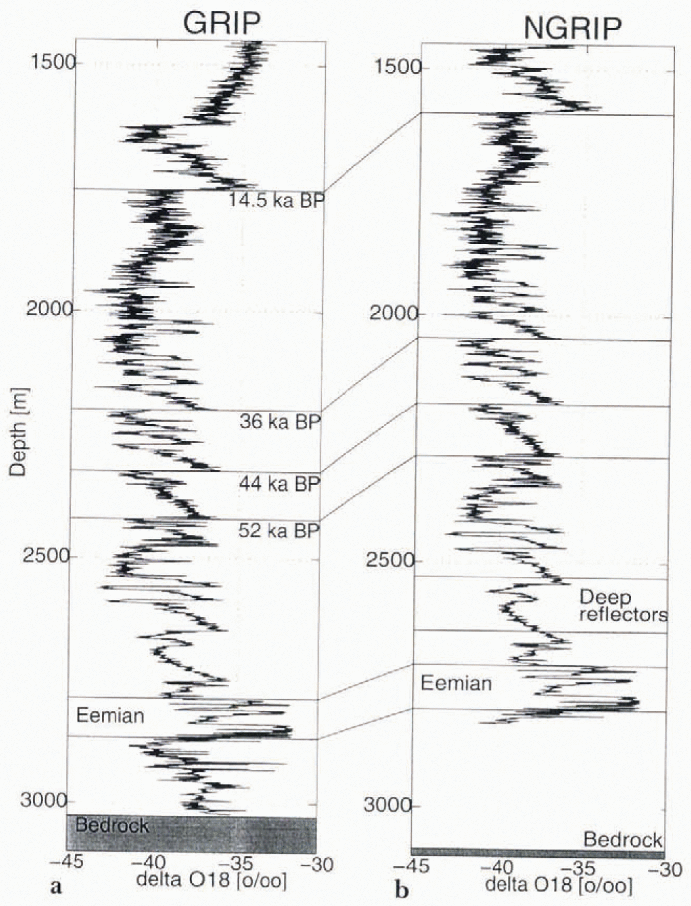
In 1992-93, two deep ice cores were completed in central Greenland; the European GRIP ice core was located on the summitpoint of the ice sheet (72.60° N, 37.62° W, elevation 3232 m; Johnson and others, 1992) and the American GISP2 ice core was drilled 28 km west of the summit (72.6° N, 38.5° W, elevation 3200 m; Reference TaylorTaylor and others,1993). These two deep ice cores provide paleoclimate information covering the last glacial period 11.5–115 ka BP (calendar years before present) with greater detail than previously obtained from any ice core. The stable-isotope records from the two ice cores agree in the top 90% of both cores, even for small-scale features (Reference DansgaardDansgaard and others, 1993:Reference Fujita and МаеGrootos and others, 1993; Reference TaylorTaylor and others, 1993; Reference Alley, Gow, Johnsen, Kipfstuhl and MeeseAlley and Others, 1995). Below depths of 2700 m, however, spanningthe Eemian (Sangamonian) interglacial period and the previous glacial, there are significant differences between the tworecords. These differences are attributed to the disturbance of the simple ice-layer stratigraphy by flow patterns uniqueto the basal zone of the ice sheet, such as folding (Reference Alley, Gow, Meese, Fitzpatrick, Waddington and BolzanAlley and others, in press; Reference Thorsteinsson, Kipfstuhl and MillerThorsteinsson and others, in press).
Even though most of the visible disturbances seem to be located below the Eemian ice in the GRIP core, the fact that these two cores show different records raises doubts about the integrity of the stratigraphic records through the Eemianinterglacial.
Ice cores do provide the best opportunity to produce a high-resolution Eemian record, so we should drill in a location where the Eemian ice is as far above bedrock as possible on the Greenland ice sheet.
An ice core drilled on the Greenland ice sheet in a region where the surface accumulation rate is lower than those atGRIP and GISP2 would produce an ice core where the location of the older ice is further from bedrock. Too low accumulation rates, however, would cause basal temperatures to reach the melting point during the glacial, and should be avoided.In this study the observations and modeling that have led to the selection of a favorable drill site in north Greenland, the North GRIP (NGRIP) site, meeting the specific criteria described above, will be discussed.
Surface, Bedrock Topography and Accumulation Rates in North Greenland
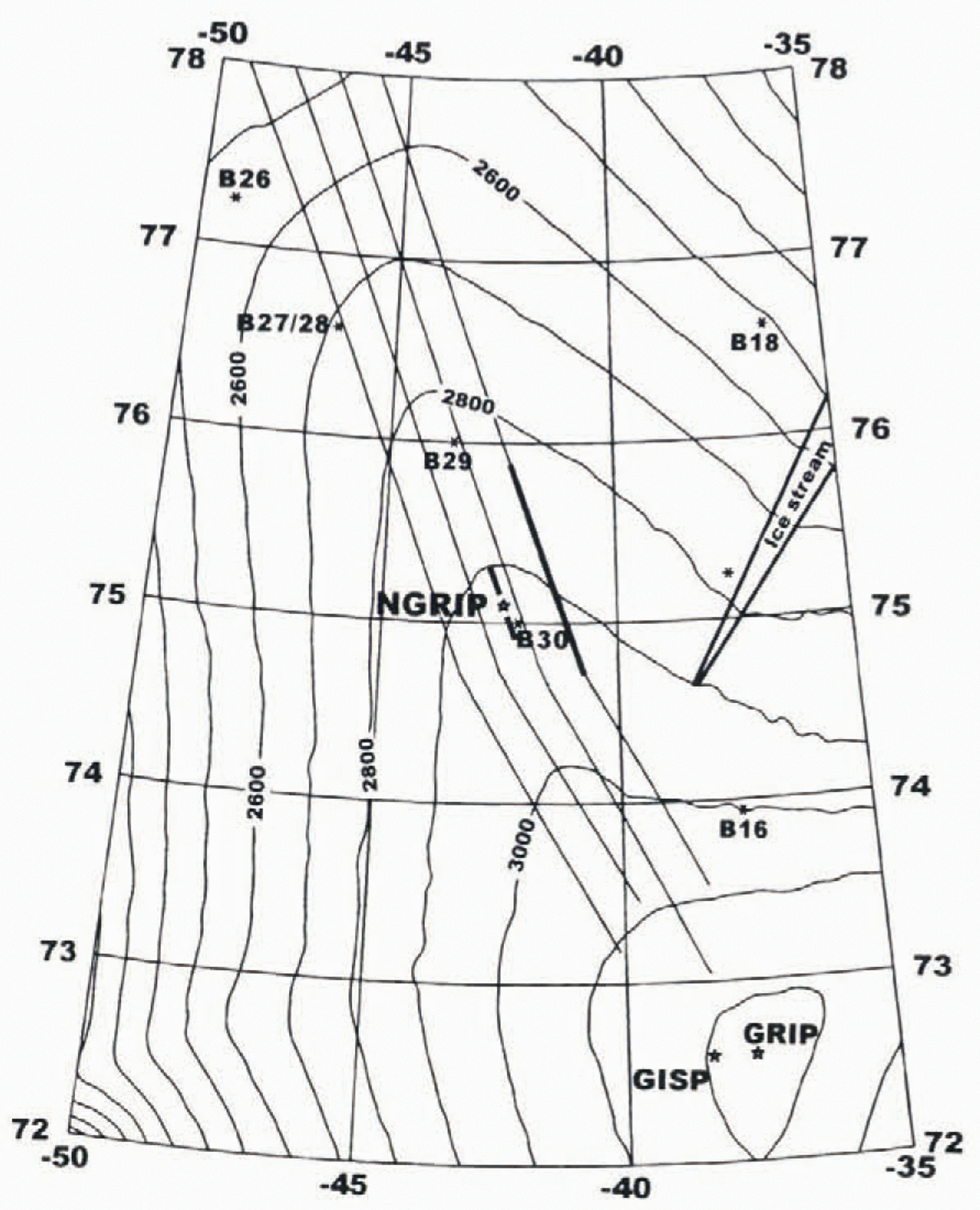
The surface contour map of north Greenland based on Geosat and ERS-1 satellite data, airborne radar altimetry and airborne laser altimetry (Reference Ekholm, Forsberg and BrozenaEkholm and others, 1995; Reference EkholmEkholm, 1996) provides the most detailed surface topography available covering north Greenland. From the summit of the ice sheet a north-northwest-(NNW)- trending ice ridge is seen to Continue550 km before it bifurcates (Fig. 1). A second northeast-trending ice ridge also leaves the summit. Results from the ERS-1 synthetic aperture radar imagery (Reference Fahnestock, Bindschadler, Kwok and JezekFahnestock and others, 1993) show an ice stream extending from the Summit region tothe north-northeast section of the Greenland ice sheet. The ice that has encountered ice-stream flow is not suitable forthe ice-core site, meeting the criteria of the studies, because the temperature near the bed is close to the melting point. The oldest ice can be melted away and may have been subject to high shear stresses.
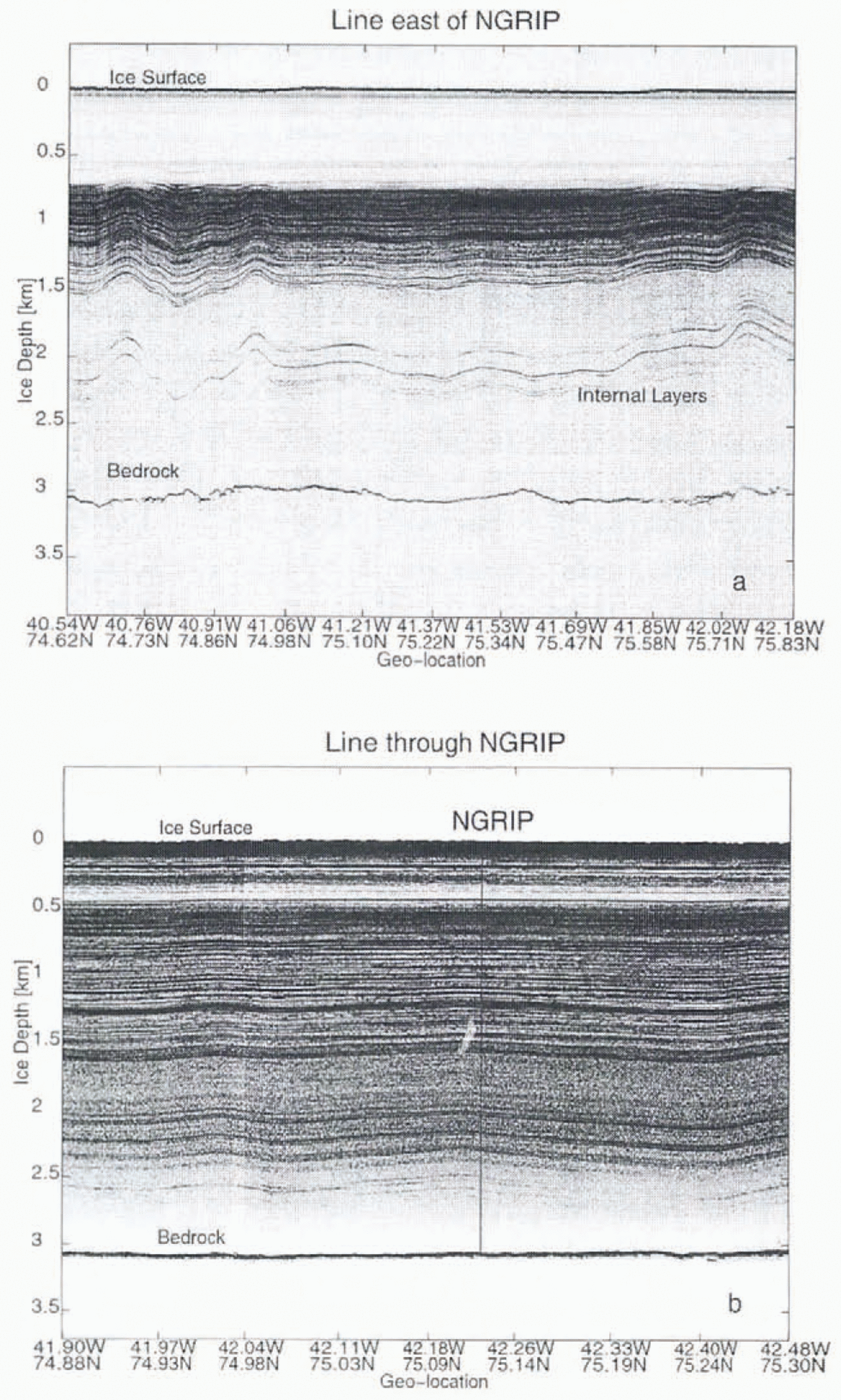
Map of north Greenland, showing surface contours, and the locations of GRIP, GISP2, NGRIP and the ice stream suggested by Reference Fahnestock, Bindschadler, Kwok and JezekFahnestock and others (1993). Locations where shallow ice cores were drilled in 1994–95 are marked B16-B30. The four parallel lines are the airborne radio-echo lines measured in 1995 by NASA and University of Kansas (Reference Chuah, Gogineni and WohletzChuah and others, 1996). The 100 km long thick line east of the NGRIP site is the part of this profile shown in Figure 5a, and the other 50 km long thick line over. NGRIP measured in 1996 is shown in Figure 5b.
From the surface contour map, the preferred drill site is on the NNW-trending ice ridge. The ice here originally fellas snow on ihe surface not far from the drill site. This simplifies the interpretation. At the ice ridge the amount of shear stress on the ice is reduced, which will help preserve the stratigraphic layering near the bedrock. A further restriction of the acceptable area arises from the criterion that the central part of the ice sheet has undergone the smallest ice-thickness changes under the past glacial. As the Eemian interglacial period had a warmer climate than at present, the size of the ice sheet may have been considerably smaller (Reference Letréguilly, Reeh and HuybrechtsLetréguilly and others, 1991a, Reference Letréguilly, Huybrechts and Reehb; Reference Fabre, Ritz and MangencyFabre and others,1995). This will introduce large ice-thickness changes, especially at sites far from the central part of the ice sheet.
A minimum of bedrock topographic relief should further reduce the risk of bottom layer disturbance. We used the bedrock topography of Reference Letréguilly, Reeh and HuybrechtsLetréguilly and others (1991a, Reference Letréguilly, Huybrechts and Reehb)together with more recent radar measurements of the bed-rock in the Summit region (Reference Hodge, Wright, Jacobel, Skou and VaughnHodge and others, 1990; Reference Jacobel and HodgeJacobel and Hodge, 1995) and along the NNW ice ridge (Reference Chuah, Gogineni and WohletzChuah and others, 1996). In general the bedrock has undulations of up to 200 m along the NNW-trending ice ridge (Fig. 2), whereas the region 170–430 km NNW of the summit has undulations smaller than 100 m.
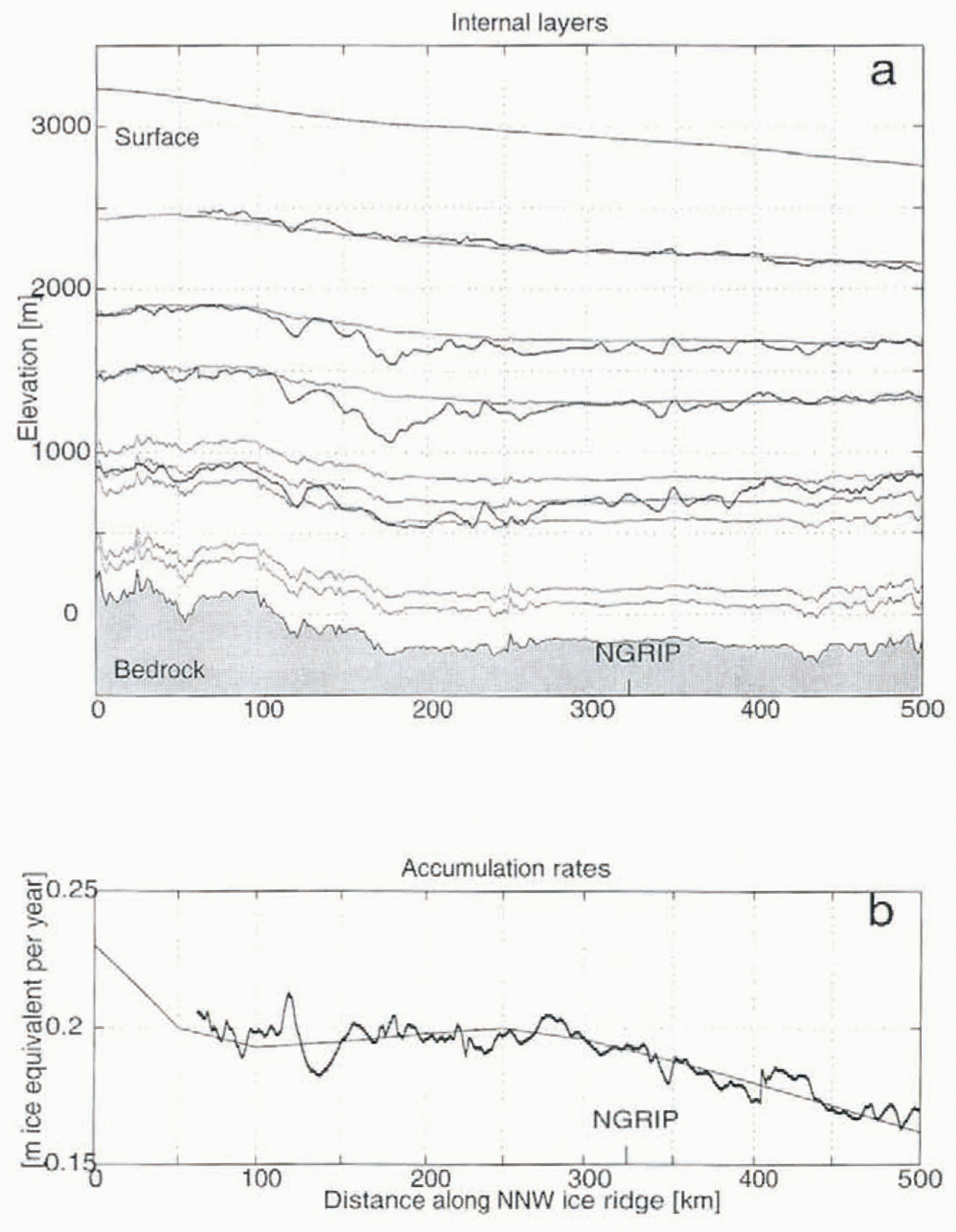
Surface and bedrock contours and observed radio-echo layers (thick black curves) along the ice ridgetrending NNW from GRIP from which distances me measured. The modeled internal layers (gray) have the ages 4, 8.6, 14.5, 36, 44, 52, 115 and 130 ka BP (calender years). (b) Surface accumulation rates (m ice equivalent year−1) used in the flow model along the NNW-trending ice ridge starting at GRIP (thin black curve). The accumulation rates are based on the observed accumulation rates from shallow ice cores in the region (Reference Clausen, Gundestrup, Bindschadler and ZwallyClausen and others, 1988; Reference Ohmura and ReehOhmura and Reeh, 1991; Reference Bolzan and StrobelBolzan and Stroebel, 1994; Reference Friedmann, Moore, Thorsteinsson, Kipfstuhl and FischerFriedmann and others, 1995; personal communication from S. Kipfstuhl, 1996). The thick black curve shows the accumulation rates reconstructed from the upper observed isochrone (4033years BP) in Figure 2a. The good agreement between the two curves shows that the accumulation rates have persisted for several thousand years.

The most crucial parameter, the surface accumulation rate, is poorly known in north Greenland. The available data have been compiled by Reference Ohmura and ReehOhmura and Reeh (1991). Data from the Summit region (Reference Clausen, Gundestrup, Bindschadler and ZwallyClausen and others, 1988; Reference Bolzan and StrobelBolzan and Stroebel, 1994; Reference Friedmann, Moore, Thorsteinsson, Kipfstuhl and FischerFriedmann and others, 1995) and from S. Kipfstuhl (personal communication, 1996), have been used to improve our knowledge of the accumulation rates along the NNW-trending ice ridge (Fig. 2b). There is a decrease in accumulation rates just north of the summit (GRIP site); after this drop the accumulation rate stays relatively constant. Accumulation ratesvary significantly across the NNW-trending ice ridge, with a decreasing gradient of 0.07 m ice equivalent year−1per 100 km toward the northeast.
Modeling of Internal Layers Along the Nnw-Trending Ice Ridge
To calculate the depth of layers of equal age (isochrones) along the NNW-trending ice ridge starting at the GRIP drill site, we use a model similar to that used to date the GRIP ice core. We calculate the ice flow using a modified Dansgaard-Johnsen (DJ) model (Reference DansgaardDansgaard and others, 1993) where the vertical strain rate is assumed to be constant from the surface S(x)to a height above bedrock h(x).It then decreases linearly to 0 at the bedrock B(x).Theinput to the model is a 150 ka accumulation-rate history calculated from the δ18O measured in the GRIPice core (Reference Dahl-Jensen, Johnsen, Hammer, Clausen, Jouzel and PeltierDahl-Jensen and others, 1993; Reference Johnsen, Dansgaard and GundestrupJohnsen and others, 1995b). The flow model is used along the NNW ice ridge, and the GRIF accumulation history is used along the ridge scaled by the ratio of the present accumulation rates at the site to those at GRIP. Transverse horizontal velocities are assumed to be zero along the line. The ice-divide ridge has a mean slope of 1 × 10⁻³along its 500 km length north of GRlP. The horizontal velocities parallel to the sloping ice ridge are believed to be related to the surface slope. Simple calculations show that over the 150 ka considered here, the horizontal ice movement along the ice ridge was no more than 10 km, which does not affect the projected location of the isochrones shown in Figures 2aand 3a. The horizontal ice movement along the ridge is thus ignored.
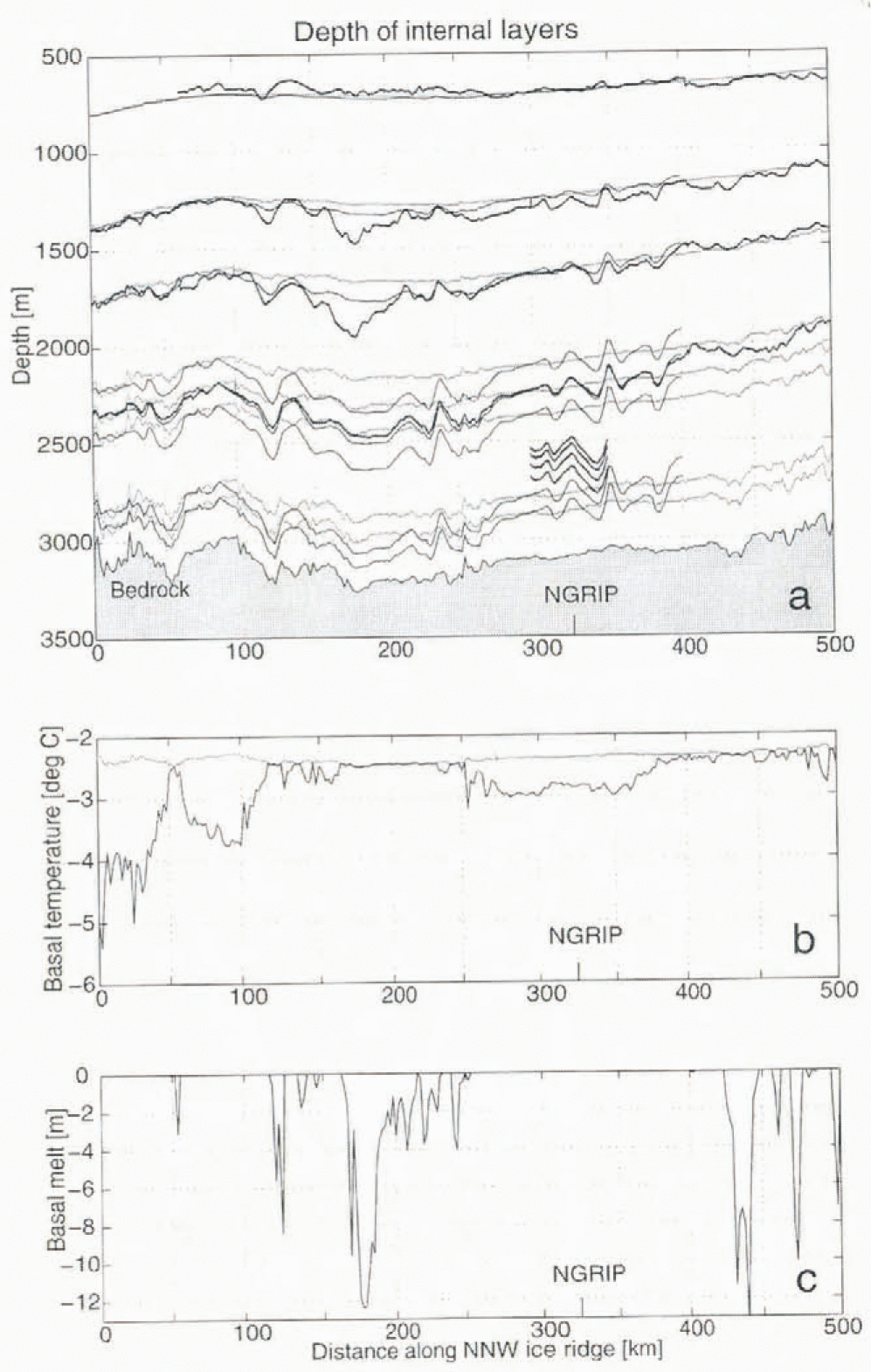
Ice depths along NNW ridge from GRIP. The depths of the modeled (gray) and oberved (thick black) internal layers also shown in Figure 2aare included. In order to explain the dips between the observed and modeled layers(shaded areas), a refined model simulation of the internal layers has been included as thin black curves, (b) The modeledmaximum basal temperatures (gray) reached during the last 150 ka along the ice ridge, compared with the pressure-meltingtemperatures (black). When the basal temperatures have reached the melting point during the glacial, basal melting has occurred. (c) Estimated amount of total basal melt during the last 150 ka; the curve is seen to match the dips.

The isochrones in Figure 2ahave been modeled so that the upper one is aged 4033 years BP (2045 BC), the next two areaged 8596 years BP (6608 BC) and 14.5 ka BP (the transition between the glacial period and the onset of the BØlling–AllerØd period), then follow three layers at GRIP depths of 2200, 2324 and 2421 m, corresponding to ages of 30, 44 and 52 ka BP, which coincide with three very prominent transitions in the interstadials (Reference JohnsenJohnsen and others,in press). The two deepest modelled isochrones, at 115 and 130 ka BP, are chosen because they represent the top and bottom of the Eemian ice, as seen in the GRIP ice core (Reference DansgaardDansgaard and others, 1993).
From Figure 2ait can be seen that the upper modeled isochrones follow the surface with depths influenced by the changing surface accumulation rates as shown in Figure 2b. The deeper isochrones are seen to follow the bedrock elevations, but they are influenced by surface accumulation rates and ice thickness as shown in Figure 3a.
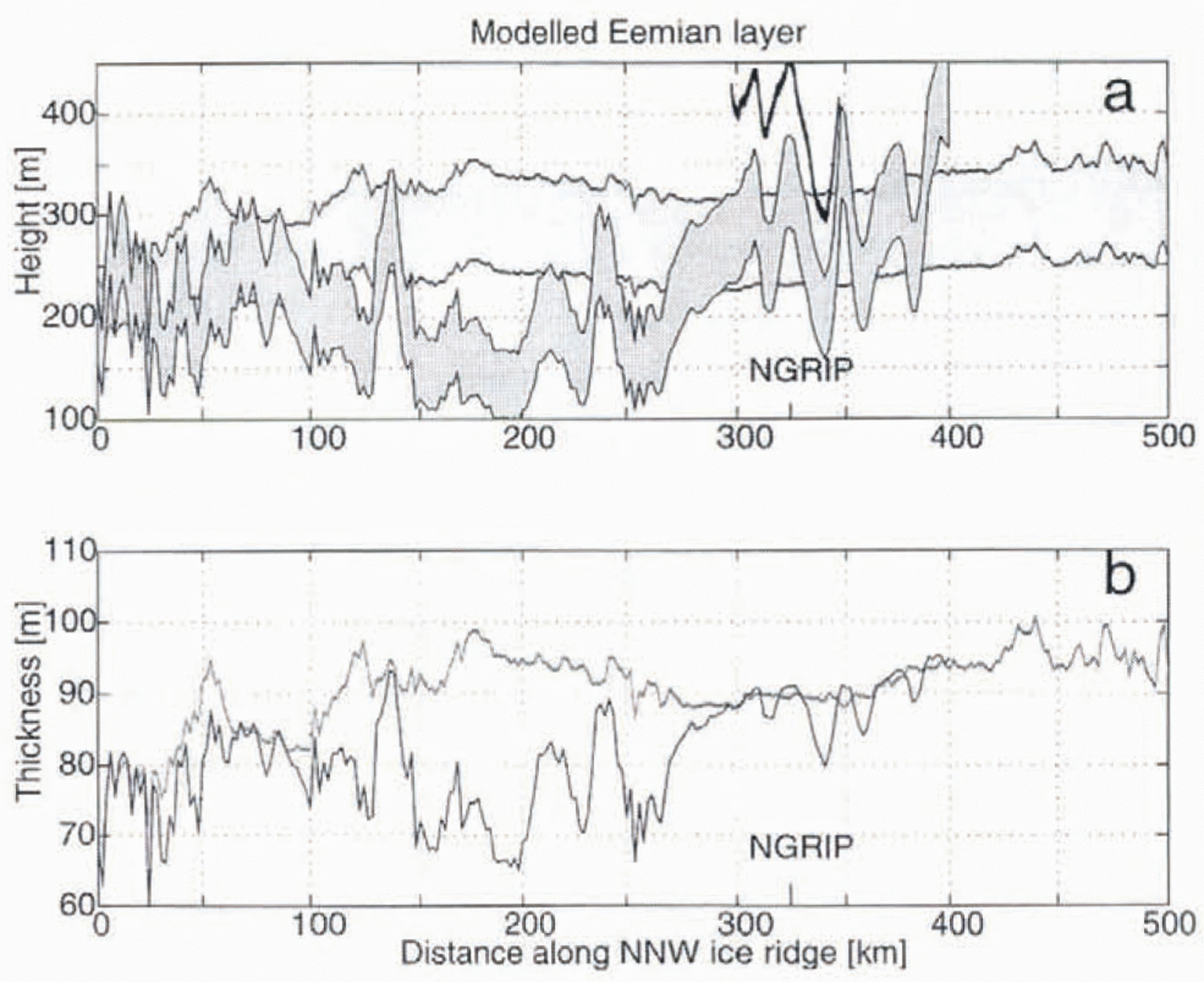
Figure 3ashows the depths of the isochrones and the ice thickness along the ridge. The depth of the 14.5 ka BP isochrone is seen to decrease from 1750 m at GRIP to 1650 m 100 km north of GRIP, because there is a drop in the surface accumulation rate from 0.23 to 0.19 m ice equivalent year−1. From 100 to 350 km the depth of the modeled isochrone is approximately constant. The elevation above bedrock of the isochrones defining the top and bootom of the Eemian layer and the thickness of the layer are shown as gray curves in Figure 4aand b. The decreasing surface accumulation rate increases both the height and the thickness of the Eemian layer over the first 100 km, after which it Stays nearly unchanged over the following 400 km.
Internal Radio-Echo Sounding Reflectors
Away to improve our knowledge on the expected location of ice in the ice sheet is to track internal layers observed from radio-echo sounding imagery over the Greenland ice sheet. Several sets of radio-echo data have been collected from north Greenland (Reference Grootes, Stuiver, White, Johnsen and JouzelGudmandsen, 1975; Reference Hempel and ThyssenHempel and Thyssen, 1993; Reference Jacobel and HodgeJacobel and Hodge, 1995; Reference Chuah, Gogineni and WohletzChuah and others, 1996), and all clearly show internal layering. The internal layers are recognized as internal reflecting surfaces of the same age (i.e. isochrones). The cause of the reflections has been discussed by several researchers (Reference HammerHammer, 1980; Reference MooreMoore, 1988: Reference Hempel and ThyssenHempel and Thyssen, 1993; Reference Fujita and МаеFujita and Mae, 1994), who conclude that changes in ice conductivity are responsible for the dielectric contrast producing these reflections and that acidic fallout from volcanic eruptions and changes in impurity concentrations, that accompany the sudden climatic transitions, are the most likely source of these changes. In most of the radio-echo records, some general structures can be identified that can be traced over large distances.
The modeled location of the Eemian layer is shown by (a) the distance above bedrock of ice aged 115–30 ka BP, and (b) the thickness of this layer along the ice ridge from GRIP trending NNW. The gray curves enclosing light shading represent the basic model results, while the black curves enclosing dark shading show the refined modelresults. In (a) the lowest-lying internal radio-echo sounding reflector is included as a thick black curve in the regionclose to the NGRIP site. 316 km from GRIP. The 115 ka top boundary of the Eemian layer traces this reflector well, whichgives us confidence in the model predictions.

Figure 5aand b show examples of the radio-echo sounding profiles collected in 1995 and 1996 by NASA and Kansas University (Reference Chuah, Gogineni and WohletzChuah and others, 1996) along the flight-lines shown in Figure 1. The profile in Figure 5ais along a line 50 km east of the NNW ridge from 74.62° N, 40.54° W to 75.83° N, 42.19° W, which is approximately 200–400 km from GRIP. The profile in Figure 5bis a 50 km long line along the NNW ridge from 74.88° N, 41.90° W to 75.30° N, 42.48° W that passes just 2 km east of the NGRIP site.
100 km section of the radio-echo imagery collected in 1995 with the 150 MHz CARDs system (Reference Chuah, Gogineni and WohletzChuah and others, 1996) along a profile 50 km east of the NNW ridge (long thick line in Fig. 1). Here the accumulation rate is reduced to 0.18 m ice eqnivalent year−1, and large oscillations of the internal layers are observed because the basal temperatures approached the melting point during the glacial period. (b) A 50 km profile collected in 1996 with the same system. The profile passes 2 km east of the NGRIP site (short thick line in Fig. 1). The reflectors сan be dated by tracing them to the dated GRIP ice core. In this way, the internal reflectors date the ice in north Greenland at the depths where the internal layers are observed.

The depth interval 100–700 m has been blocked in data processing to obtain the maximum possible resolution of the deep-lying reflectors. The shallowest reflector identified occurs at a depth of 700 m on most of the images and can be recognized in the GRIP ice core as a volcanic horizon 4033 years BP (Reference Clausen, Hammer, Hvidberg, Dahl-Jensen, Steffensen and LegrandClausen and others, in press). Another very prominent reflector is found at a depth of 1300 m and is believed to be a strong volcanic horizon 8596 years BP. A gap is observed beginning at a depth of 1600 m. The transition between the more prominent internal reflectors and the gap coincides with the onset of the BØlling-AllerØd 14.5 ka BP (Reference HammerHammer, 1980; Reference Hempel and ThyssenHempel and Thyssen, 1993). The gap withweak or no reflectors thus coincides with ice from the cold Last Glacial Maximum. Three layers can be identified clearly700–1100 m above bedrock. These have been discussed in Reference Grootes, Stuiver, White, Johnsen and JouzelGudmandsen (1975)and Reference Jacobel and HodgeJacobel and Hodge (1995)and can be tracked in most of the radio-echo data from North Greenland (Reference RishØjgaardRishØjgaard, 1989). Reference Grootes, Stuiver, White, Johnsen and JouzelGudmandsen (1975)and Reference Hempel and ThyssenHempel andThyssen (1993)suggest that the reflectors are sharp transitions associated with the interstadials. The radio-echo sounding reflectors can be traced back to the GRIP site, where the ice core has been dated. In Figure 5bsome very weak reflectors are observed 300–500 m from the bedrock. These can be seen only on the radio-echo profiles from 1996, so they cannot be tracked back to the GRIP site.
Comparison of Observed and Modeled Internal Layers
In Figure 5athe oscillations of the elevations of the three deep-lying reflectors 700–1000m above bedrock areunexpected. These oscillations are not generated by bedrock undulations, as the bed is quite smooth here and no surface undulations support the internal oscillations. In addition, the oscillations are less pronounced in shallower layers. The oscillations could be caused by variations of the surface accumulation rates or by variations of the dynamic velocity fields along the ridge.
Variations of the surface accumulation rates could be caused by movement in the east-west direction of the NNW-going ice ridge back in time. The flow model described earlier is used to model the flow along the line shown in Figure 5a, 50km east of the NNW ice ridge. The surface accumulation rate is known to be 0.18 m ice equivalent year−1in this region, and the model results reveal that the accumulation rate must vary between 0.14 and 0.19 m ice equivalent year−1along the line in order to generate oscillations of the observed magnitude 700–800 m above bedrock. This seems unlikely as the surface contours and the accumulation pattern are so smooth in this region, and it would be difficult for ice-ridge movements to produce this pattern.
To explore the possibility of variations in the velocity fleld along the ridge, we have calculated a 150 ka history basal temperature using a thermodynamic ice-flow model (Reference Dahl-Jensen, Johnsen, Hammer, Clausen, Jouzel and PeltierDahl-Jensen and others, 1993; Reference Johnsen, Clausen, Dansgaard, Gundestrup, Hammer and TauberJohnsen and others, 1995a) driven by the surface temperature and accumulation-rate histories generated from the GRIP stable-isotope record (Reference Johnsen, Clausen, Dansgaard, Gundestrup, Hammer and TauberJohnsen and others, 1995a). Since the present surface accumulation rate decreases towards the north, the accumulation-rate history fromGRIP is scaled at each site by the present accumulation rate between that site and GRIP. The present surface temperatureis nearly constant in this considered region of north Greenland, so the GRIP surface temperature history can be used over the entire flowline. The modeled basal temperature increases as the surface accumulation rates decrease, because less cold snow moves down into the ice sheet. Where the present surface accumulation rate is less than 0.18 m ice equivalent year−1, the basal ice reaches the pressure-melting point during the glacial for an ice thickness of 3000 m. Increasing ice thickness increases the basal temperature by approximately 2° C per 100 m. The warmest basaltemperatures are reached during the glacial and are roughly 2.5° C warmer than the present basal temperatures. The radio-echo sounding profile shown in Figure 5ais in a region where the present surface accumulation rate is 0.18 m ice equivalent year−1and the ice thickness is fairly constant. Basal melting thus could have occurred during the glacial.
When the basal ice is close to the pressure-melting point, both bottom sliding and basal melting can occur. Both processes drag the internal layers downward. Basal sliding allows layer thinning right down to the bedrock, and basal melting moves the layers right down to the bedrock. We can match the observed oscillating internal layers by varying h(x),the height above which the vertical strain rate is assumed to be constant in the DJ model, between 400 and 2000m andallowing 10–70% of the horizontal velocity to be basal sliding and simulating sliding and non-sliding conditions.Non-sliding is believed to have occurred where the internal layers are located furthest from bedrock, while sliding is believed to have dragged the layers downwards in the remaining regions.
Sliding does not appear to have taken place everywhere along the profile in Figure 5a. When the ice is close to the pressure-melting point, small spatial variations in geo-thermal heat flux could create the spatially variable sliding pattern. Geothermal flux would be expected to vary with bedrock geology.
We conclude that the second explanation of the internal oscillations, as being a result of varying velocity fields, is preferred. The first explanation is rejected because we would have to assume unreasonably large variations in the surface accumulation rate. Also the internal oscillations generated by sliding/non-sliding conditions will increase with depth, while the oscillations generated by variations of the surface accumulation rate will decrease when bed-rock is approached. For the selection of a drill site whose prime objective is to study the deep-lying ice, it is very important to avoid the zones where basal temperatures approach the pressure-melting point.
The observed internal layers along the NNW-trending ice ridge are included in Figures 2a and 3a as thick black lines.The upper reflector at 700 m depth (4033 years BP) can be used to determine if reasonable accumulation-rate values have been used in the calculations, as this layer is nearly unaffected by the bedrock and possible variations of the velocityfields. The reconstructed surface accumulation rate from the upper internal layer is shown in Figure 2bas a thick blackcurve. This curve, which represents the accumulation during the last 4000 years, is seen to agree reasonably with the accumulation-rate profile used in the calculations. This confirms that the significant drop of the accumulation rate 50 kmnorth of GRIP as reported by Reference Bolzan and StrobelBolzan and Stroebel (1994), who used 20 m deep shallow ice cores containing firn from 50 years’ accumulation, has persisted for a long time.
The age of the modeled isochrones shown in Figures 2a and 3a (thick gray curves) has been chosen so they have the same age as the observed radio-echo sounding reflectors between the GRIP and the NGRIP drill sites. The reflectors are seento compare Well with the modeled isochrones except at 100–270 km from GRIP along the NNW-trending ice ridge. Hereall the reflectors clip simultaneously up to several hundred meters. The surface accumulation rate is 0.19 m ice equivalent year−1here, but the ice thickness can be seen to increase to 3250 m 175 km from GRIP where the greatest dip is found. This ice-thickness increase will result in basal temperatures reaching the pressure-melting point during the glacial period. Figure 3bcompares the maximum basal temperatures, which are reached during the glacial, with the ice-thickness-related pressure-melting point. In regions where basal temperatures reach the melting point the amountof ice that has been melted during the last glacial is shown in Figure 3c. Basal melt occurs in regions where the reflectors are seen to dip, and the amount of predicted basal ice melted shown in figure 3c has the same shape as the dips (shaded areas in Figure 3a). The internal layers may be dragged down here due to changes of the velocity fields caused by basal melting conditions, as discussed earlier, for the line lying 50 km to the east (Fig. 5a).
A refined modeling of the Observed radio-echo reflectors has been attempted by adjusting the dynamic velocity fields to sliding and non-sliding conditions along the line, as discussed earlier. The refined modeled layers are shown as thinblack curves in Figure 3a. They are seen to match the oscillations of the internal layers at all depths except 150–200 km, where the layers dip most. Around the NGRIP site, 316 km from GRIP, the refined model layers can be compared with the deep reflectors (depths 2500–2750 m) from Figure 5b. The refined model dates these reflectors to 80–100 ka BP. The toр and bottom of the modelled Eemian layers are shown as thin black curves in Figure 3a. The amplitude of the small oscillations of the thin black curves is seen to agree well with that from the observed deep reflectors, which gives confidence in the predicted location of the Eemian layer in the NGRIP ice core.
Discussion
We are searching for an ice-core site in Greenland where a reduced accumulation rate raises and thickens the Eemian ice layer while avoiding basal melting. The region upstream of the site should have flat bedrock to reduce oscillations of the internal layers. The site should be on an ice ridge to ensure minimum horizontal velocity and in the center part of the ice sheet to reduce possible ice-thickness changes back in time.
Calculations with a thermomechanical flow model indicate that when the surface accumulation rate drops below 0.18 m ice equivalent year−1, the pressure-melting point is reached for an ice thickness similar to that foundat GRlP (3027 m). The ice thickness also affects the basal temperature, so an increase of 100 m results in a 2°C warming of the basal ice.
Taken together, it is clear that we restrict favorable coring sites to a very small region. A poor selection could result in a site where the ice from the Eemian period has been dragged down to the bedrock and the oldest ice is melted away instead of being elevated.
The modeled prediction of the height and thickness of the Eemian layer (115–130 ka BP) along the NNW-trending ice ridge Starting at GRIP is shown in Figure 4a and b as gray curves. The major elevation and increase of thickness happens during the first 50 km because the surface accumulation rate decreases from 0.23 to 0.19 m ice equivalent year−1. From 50 to 400 km there are small changes in the location of the Eemian layer. There is a region 50–250 km from GRIP where the observed reflectors dip up to 200 m when compared to their modeled positions. In this region the ice thickness increases to 3250 m, causing the basal temperature to approach the pressure-melting point. Between275 and 390 km north of GRIP the ice thickness decreases and the modeled and observed internal layers agree again. Further north the accumulation rate drops, so basal ice again can be expected to reach the pressure-melting point. A refined modeling of the position of the Eemian layer (black curves in Figure 4a and b) allows us to match the observed reflectors except between 150 and 200 km. where the dip is greatest. The Eemian layer is first seen to rise at 275 km distance from GRIP north of the region where basal melting probably has occurred. The deepest observed radio-echo sounding reflector is included as a thick black curve in Figure 4a because it demonstrates the reliability of the refined modeling of theposition of the Eemian layer around NGRIP.
The age-depth profile for the NGRIP site, modeled by the refined model, is shown in Figure 6b. Here the stable-isotope profile, δ18O, measured and dated on the GRIP ice core (Fig. 6a), has been transferred to the NGRIP site. The radio-echo layers discussed in the previous sections are also shown. The transition from Holocene to glacial ice is predicted to be found at a depth of 1460 m. For ice younger than 40 ka, layer thicknesses at NGRIP are thinner than at GRIP; the situation is reversed for older ice.
Simulations of the expected time-scale at NGRIP with the refined model. The δ18O profile measured on the GRIP ice core is plotted on the NGRIP time-scale. The NGRlP “climate curve” (Fig. 6b) is compared to the GRIP “climate curve” (Fig. 6a). The internal radio -echo reflectors that have been traced between the GRIP and the NGRIP site (14.5, 36, 44 and 52 ka BP) ensure that the predicted depth-age profile at NGRIP is correct down to 2300 m depth. The depth interval where the deep reflectors are observed on the radio-echo imagery from 1996 (Fig. 5b) demonstrates that the ice is still layered at depths just above the Eemian ice at NGRIP.

Conclusions
We suggest that a drill site should be localed 275–375 km from GRIP along the NNW-trending ice ridge. The NGRIP ice core is now being drilled in the region 75.120° N, 42.350° W (316 km from GRIP along the NNW-trending ice ridge) where the surface elevation is 2919 m, ice thickness is 3085 m and the surface accumulation rate is 0.190 ± 0.005 m ice equivalent year−1. The bedrock is smooth in this region (Fig. 5b).
The deepest layer that can be traced to GRIP is found 700 m above the bedrock at the NGRIP site, and has an age of 52ka. Because our modeled ages for all the traceable layers agree well with the dates at GRIP, we can confidently use the flow model to date the deeper reflectors (Figs 5b and 3a) at 500–300 m above bedrock to 80–100 ka, respectively.
Using these layers dated by the GRIP core, we have produced a depth-age scale for the NGRIP core that is well constrained by data to 52 ka, and confidently dated to 100 ka by flow modeling (Fig. 6). The layers confirm that the ice 300 m above the bed has not been significantly disturbed.
The ice from the Eemian period 115–135 ka BP should be found at depths of 2750–2850 m at NGRIP. The sequence is 20 m (25%) thicker than the Eemian sequence at GRIP. The onset of the Eemian period (135 ka BP) should be found235 m above bedrock at NGRIP; this is 120 m higher above the bed than the Eemian ice at GRIP. Therefore, we expect the NGRIP site to offer a significantly better opportunity to recover an undisturbed Eemian sequence than the Summit region (GRIP and GISP2), and possibly the best opportunity anywhere in the Greenland ice sheet. The NGRIP drilling commenced in 1996, and reached a depth of 354 m. When then bedrock is reached, we will know!
Acknowledgements
Funding of the NGRIP program by the Danish Science Foundation has made this work possible. The U.S. National Seicute Foundation-Office of Polar Programs grant 9123660 supported E. Waddington’s contribution to the research and allowed D. Dahl-Jensen to visit Scattle Over several periods to work on the paper. Suggestions from D. MacAyeal have improved the paper. The NASA flights along the ice ridge in 1995 and 1996, where the radio-echo sounding profiles were collected, were most valuable for the selection of the NGRIP drill site, for which we thank NASA and the University of Kansas.