

Introduction
Melting sea ice and technological advances hold the potential to open the Arctic Ocean to new resource development and scientific discovery. It is believed that the Arctic holds significant hydrocarbon resources, along with deposits of critical minerals, including rare earth elements. This makes the question of “who owns the Arctic” of considerable importance economically and strategically.
While no state can lawfully claim sovereignty over the Arctic Ocean, nearly all of its seabed falls under the jurisdiction of one or more coastal states. This is due to a combination of legal and geographic factors. As a legal matter, international law recognizes that a coastal state has jurisdiction over its continental shelf—the submerged extension of its landmass—with rules for determining continental shelf limits provided for in the 1982 UN Convention on the Law of the Sea (Convention). As a geographic matter, the Arctic Ocean is ringed by five coastal states—Canada, Denmark (Greenland), Norway, Russia, and the United States—each of which projects its continental shelf entitlement toward the central Arctic, in most cases based on large undersea ridges and other elevations that extend from the landmasses of these coastal states. As discussed in this essay, the interplay of these factors yields not only large continental shelf areas, but also a complex and still-evolving picture of the Arctic seabed.
The continental shelf differs in important ways from other maritime zones, such as the territorial sea (which extends a maximum 12 nautical miles from the coast) and the exclusive economic zone (EEZ, which extends from 12 to 200 nautical miles from the coast).Footnote 1 Unlike the territorial sea and the EEZ, the continental shelf pertains only to the seabed and subsoil. And, unlike the EEZ, the continental shelf can extend beyond 200 nautical miles from the coast, provided that the relevant criteria in the Convention are satisfied. Beyond the continental shelf limits of all states is the international seabed “Area” which, along with its mineral resources, is what the Convention characterizes as the “common heritage of mankind.”Footnote 2 Figure 1 presents a simplified diagram of maritime zones under the international law of the sea, as reflected in the Convention. Although the Convention does not assign a moniker to the continental shelf beyond 200 nautical miles, for convenience, it is often referred to as “extended continental shelf.”
Simplified diagram of maritime zones under the international law of the sea (Source: U.S. ECS Project).

The continental shelf matters to states primarily because of resources and science. International law affords a coastal state exclusive “sovereign rights” to natural resources of its shelf and “jurisdiction” over scientific research, as well as other rights.Footnote 3 While continental shelf rights are exclusive to the coastal state, this characterization merits a caveat in the case of the Arctic, where continental shelf entitlements of Arctic coastal states overlap with one another to a greater degree than most other maritime areas. In the coming years, Arctic coastal states will need to undertake extensive maritime delimitation efforts to establish mutually agreed boundaries in areas of continental shelf overlap.
The Continental Shelf in International Law
From a scientific perspective, the continental shelf is a physical feature of the world’s oceans, namely the shallow seabed areas (typically less than 200 meters depth) that extend seaward from the coast to where depths increase markedly.Footnote 4 If the legal definition were to follow the scientific one, the continental shelf would be more modest in size in the Arctic and elsewhere. The more capacious modern legal definition, set forth in Article 76 of the Convention, includes the scientific “shelf” described above, as well as the rest of the “continental margin,” namely the continental slope and rise.Footnote 5 It also includes any area of seabed between 12 and 200 nautical miles of the coast, regardless of the physical characteristics of the seabed.
Where a coastal state’s continental margin extends beyond 200 nautical miles from the coast, Article 76 of the Convention provides formulas for determining the exact outer limits of the extended continental shelf. The rules are based on the physical properties of the seabed and subsoil, including the location of the “foot of the continental slope,” the “thickness of sedimentary rocks,” and the “2500 meter isobath,” which is a line connecting 2,500 meter depths. The complex rules in Article 76, which were the product of extensive negotiations during the 1970s, are widely respected as a matter of both treaty law and customary international law.Footnote 6
Applying the rules in Article 76 requires the collection and analysis of marine geophysical data, such as bathymetric mapping that measures the depth and shape of the seabed and seismic data that measure sediment thickness. The United States, for instance, has undertaken ten data collection missions in the Arctic Ocean, six of which were done cooperatively with Canada, for the purpose of determining extended continental shelf limits.Footnote 7 Other Arctic coastal states have undertaken efforts of a similar scale to obtain the necessary bathymetric and seismic data.
The Convention also establishes an expert body and a procedure to assist coastal states with determining their extended continental shelf limits and help avoid disputes over such limits. Specifically, Article 76 requires coastal states to submit “[i]nformation on the limits of the continental shelf beyond 200 nautical miles” to the Commission on the Limits of the Continental Shelf (CLCS).Footnote 8 This body of twenty-one scientific experts is charged with reviewing data and other materials submitted by a coastal state concerning its continental shelf limits and, based on that review, making “recommendations” to coastal states. The rationale for the CLCS’s existence is apparent in light of the scientific and technical complexity of the rules in Article 76.
The CLCS does not “determine” extended continental shelf entitlement or limits. It is long established that continental shelf rights exist ipso facto and ab initio and, as the International Tribunal for the Law of the Sea (ITLOS) has affirmed, the Convention’s requirements with respect to the CLCS do “not imply that entitlement to the continental shelf depends on any procedural requirements.”Footnote 9 The CLCS’s recommendations nevertheless carry considerable weight, particularly when the coastal state and the CLCS agree on the location of the limits. If the coastal state establishes its limits “on the basis of” the CLCS’s recommendations, Article 76 provides that those limits are “final and binding.”Footnote 10 Alternatively, if a coastal state disagrees with the CLCS’s recommendations, it must “make a revised or new submission” to the CLCS.Footnote 11 Continental shelf limits established by a coastal state that are not founded on CLCS recommendations would not be “final and binding,” leaving it up to other states to evaluate the credibility of such limits.
At the time of writing, seventy-five different coastal states have made ninety-eight continental shelf submissions to the CLCS, and the CLCS has made thirty-seven recommendations to coastal states.Footnote 12 The considerable disconnect between the number of submissions filed and the number of recommendations issued by the CLCS reflects the long backlog of submissions awaiting review, including several filed by Arctic coastal states.
Continental Shelf in the Arctic Ocean
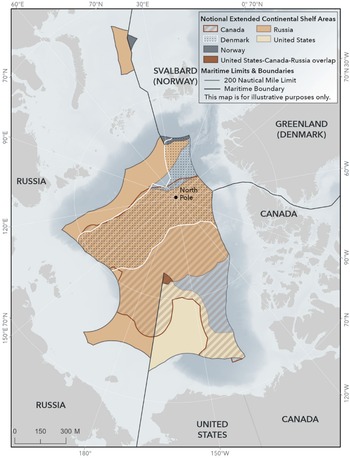
This section summarizes the extended continental shelf areas in the Arctic asserted by Russia, Norway, Denmark (Greenland), Canada, and the United States, as well as the recommendations issued by the CLCS pertaining to those areas. The present picture of extended continental shelf areas asserted in the Arctic Ocean, including the areas of considerable overlap, is provided in Figure 2. Figure 2 also shows a small window in the Arctic where no country has asserted an extended continental shelf area.
Continental shelf areas asserted by coastal states in the Arctic. The figure depicts only continental shelf beyond 200 nautical miles from the coast, commonly referred to as extended continental shelf (Source: U.S. ECS Project).

A country-by-country discussion of extended continental shelf is best prefaced by a cross-cutting issue common to multiple Arctic coastal states, namely, seafloor elevations. As noted earlier, the sizable continental shelf areas in the Arctic Ocean are explained by large ridges and other seafloor elevations. The Lomonosov Ridge spans the Arctic Ocean, joining the margin of Russia (East Siberian Shelf) with the margins of Canada and Greenland (Lincoln Shelf). The Alpha-Mendeleev Ridge complex similarly spans the central Arctic Ocean. A third seafloor elevation, the Chukchi Borderland, extends north from the U.S. state of Alaska. The Chukchi Borderland, in turn, is connected to the Alpha-Mendeleev Ridge complex. There is little doubt that the aforementioned seabed elevations form part of the continental margins of one or more Arctic coastal states. A fourth Arctic seafloor elevation, Gakkel Ridge, is a seafloor spreading ridge, and its status as continental shelf is in doubt.
Russia was the first country to assert its extended continental shelf limits in the Arctic and elsewhere. It has also asserted the largest shelf in the Arctic. Russia filed submissions with the CLCS (including revised and amended submissions) pertaining to the Arctic in 2001, 2015, 2021, plus two additional submissions in 2023.Footnote 13 In successive submissions, Russia has asserted limits that encompass progressively larger areas of the continental shelf in the Arctic. The CLCS issued initial recommendations to Russia in 2002, followed by two additional sets of more substantive recommendations in 2023. Taken together, these recommendations are largely favorable to Russia, with the exception of Russia’s continental shelf assertion in the vicinity of Gakkel Ridge. The CLCS has not acceded to Russia’s view, as presented in its most recent 2023 submission, that this seafloor spreading ridge is part of its continental margin.
Norway submitted its continental shelf limits to the CLCS in 2006 and received favorable recommendations in 2009.Footnote 14 Norway’s continental shelf appears to be the smallest of the Arctic coastal states. However, Norway has not yet formally established its continental shelf limits on the basis of the CLCS’s recommendations. Accordingly, it retains the option, as do other Arctic coastal states, of filing a new or revised submission to the CLCS.
Denmark, together with Greenland, made a submission to the CLCS in 2014 pertaining to the Arctic north of Greenland.Footnote 15 Like the continental shelf of Russia, Denmark asserts a continental shelf that extends across the Arctic Ocean. Canada likewise asserted a large continental shelf in the Arctic in its 2019 and 2022 submissions to the CLCS—larger than Denmark’s and nearly as large as Russia’s.Footnote 16 At the time of writing, the CLCS has not yet reviewed either the Canadian or Danish/Greenlandic submissions. However, there is little doubt that both countries have considerable continental shelf entitlements in the Arctic, due to the Lomonosov Ridge and Alpha-Mendeleev Ridge complex, described above.
Finally, the United States asserted its continental shelf limits in 2023, including in the Arctic region.Footnote 17 These limits encompass the Chukchi Borderland and surrounding areas, north of Alaska. Like other Arctic coastal states, the U.S. continental shelf limits are based on the application of the rules in Article 76 of the Convention. However, while other Arctic coastal states asserted their continental shelf limits via a submission to the CLCS, the United States did not. The U.S. continental shelf limits were instead announced by the U.S. Department of State, along with supporting information. The announcement stated that the United States would file a submission upon joining the Convention and that it is open to filing a submission as a non-party to the Convention.Footnote 18
Maritime Boundary Delimitation
When the maritime zones of neighboring states overlap, boundaries are needed to divide those overlaps. Article 83 of the Convention provides that the delimitation of the continental shelf “shall be effected by agreement on the basis of international law … in order to achieve an equitable solution.” In the absence of reaching an agreement, states may establish their maritime boundaries by resorting to third party dispute settlement, such as with ITLOS or the International Court of Justice. Thus far, there are three agreed continental shelf boundaries in the Arctic Ocean, each concluded by agreement (Figure 2).
The first continental shelf boundary in the Arctic was concluded between the United States and Russia in 1990.Footnote 19 Although the entry into force of this 1990 treaty is still pending Russian ratification, the agreement has proven durable, as the two countries have provisionally applied it since its date of signature. The 1990 treaty establishes a maritime boundary between the two states that extends into the central Arctic along a defined meridian, but without specifying a precise northern terminus. Instead, it provides that the maritime boundary between the United States and Russia “extends … into the Arctic Ocean as far as permitted under international law.” This ensures that the boundary will continue to have effect, so long as the two states have abutting continental shelf areas that require separation.
Russia and the United States have delineated their extended continental shelf limits in the Arctic in a manner largely consistent with the 1990 Agreement. The U.S.-Russia boundary forms the western limit of the U.S. continental shelf area and, conversely, the eastern limit of Russia’s continental shelf. The limits asserted by Russia, however, do cross the boundary where the interests of a third state (Canada) come into play, as shown on Figure 2.
The second continental shelf boundary in the Arctic is between Norway and Russia, agreed in 2010 and in force since 2011.Footnote 20 This boundary commences just seaward of the Norway-Russia land boundary in the Barents Sea and extends into the Arctic Ocean, north of (and between) Svalbard (Norway) and Franz Josef Land (Russia). Like the U.S.-Russia boundary treaty, the Norway-Russia treaty does not establish an exact boundary terminus. In practical terms, the treaty establishes a boundary that ends where the continental shelf of Norway ceases to overlap with that of Russia.
The third and most recent maritime boundary in the Arctic is between Canada and Denmark (together with Greenland), agreed in 2022.Footnote 21 This boundary, however, does not delimit the extended continental shelf in the Arctic Ocean. Rather, it stops at the 200 nautical mile EEZ limit of the two countries, leaving the Canada-Denmark extended continental shelf boundary in the central Arctic Ocean for future negotiation.
The remaining boundary delimitation tasks in the Arctic are formidable. Four boundary “pairs” are particularly important. First, the United States and Canada must divide their areas of overlapping continental shelf in the Beaufort Sea and central Arctic. The two governments formed a task force to negotiate the boundary in September 2024.Footnote 22 However, both countries experienced a change in government in 2025, and no subsequent developments have been announced.
The second, third, and fourth boundary pairs concern Canada-Russia, Canada-Denmark, and Denmark-Russia. The three countries have massive overlapping extended continental shelf areas in the central Arctic, including at the symbolic North Pole. It remains to be seen whether these boundaries are negotiated bilaterally or trilaterally. It likewise remains to be seen what method of boundary delimitation the countries use, as well as whether these Arctic coastal states wish to await further recommendations of the CLCS prior to undertaking boundary negotiations. As noted above, however, irrespective of any future CLCS recommendations, there is no doubt that the three countries have large overlapping continental shelf areas in the central Arctic.
Conclusion
Arctic coastal states have significant interests in securing their sovereign rights and jurisdiction over their extended continental shelves. In the Arctic, as in other regions, law and science determine continental shelf limits of coastal states. However, given the enormous continental shelf areas and overlaps in the Arctic, the conclusion of maritime boundary agreements would enable countries to exercise the full extent of their continental shelf rights and jurisdiction without controversy. The map shown in Figure 2 is a snapshot in time. That map looked different a decade ago, and it will likewise evolve in the coming years, depending on revisions that coastal states may make to their continental shelf limits and bilateral or trilateral boundary treaties concluded among them.


 Open access