
Measuring two miles long and one mile wide, Pitcairn is a very small place. For most of its history, the island had fewer than a hundred inhabitants, almost all descendants of a handful of British sailors and Tahitian women who settled there in the aftermath of the famous mutiny on His Majesty’s Armed Vessel (HMAV) Bounty. Pitcairn is also extremely remote. Sitting some five hundred miles from any other inhabited island and far from major trade routes, it has an unprotected anchorage that has hindered regular commerce. With scant arable land and few natural resources, the island has been heavily dependent on passing ships for material support.
These conditions make Pitcairn an unlikely place to test the nature and reach of British imperial sovereignty. Yet questions about when Pitcairn became British have drawn extensive commentary and heated disagreement. Such controversies have prompted serial attempts to set the record straight. The most recent pronouncement on Pitcairn’s legal status came in 2006, when the court of final appeal for British Overseas Territories and Crown Dependencies affirmed British criminal jurisdiction on the island. Responding to a final challenge brought by a group of Pitcairn men convicted in a case that commenced in 2004, the Judicial Committee of the Privy Council declared that for “over a hundred years Pitcairn has been administered by the Crown as a British possession.”Footnote 1
The court’s pronouncement did little, however, to settle ongoing controversies about the island’s past status. Scholars have offered contrasting views on when Pitcairn became British, and an expansive and unusually detailed archive provides ample opportunities for cherry-picking in support of favored interpretations. The British public was fascinated by the romantic story of an English speaking, Anglo-Tahitian Christian community subsisting on a tiny speck of land in the South Pacific. Faced with an insatiable appetite for descriptions of the island and its population, Pitcairn’s residents obliged with self-serving narratives depicting an island paradise, and navy captains penned their own detailed accounts, many of which were rapidly published. Pitcairn also attracted a handful of adventurers and would-be island leaders who created their own documentary trails.
This article offers a new narrative of Pitcairn’s history. Rejecting accounts that emphasize the island’s exoticism and isolation, and questioning assumptions about imperial annexation and its timing, we expose the inner workings of a regime of naval oversight and of local power struggles that together ordered island-imperial relations. Our account overturns commonly repeated claims that Britain settled or took possession of Pitcairn as a matter of policy. We also aim to refute competing arguments that British captains engineered the creation of an independent polity with its own constitution. Instead, we trace how repeated reconfigurations of island-imperial connections worked to prevent Pitcairn from being enfolded into the empire or being established as an independent entity. Legal maneuvering on all sides served to perpetuate sovereign indeterminacy.
The significance of this narrative extends far beyond one small island. Using a microhistorical study of Pitcairn to illuminate broader processes of interpolity ordering, we locate the origins of sovereign indeterminacy in what we call the “legal circuitry” of nineteenth-century empire. Legal practices that were less structured than institutions and more systemic than ad hoc interventions delivered oscillating imperial power to Pitcairn, as they did to other Pacific places on or beyond the edges of empire.Footnote 2 Formative practices included naval patrols, quasi-legislative actions, and fitful patronage arrangements. Together, they delivered a weak current of imperial administration while sustaining both a measure of local autonomy and the possibility of sudden interference.
This perspective aims to merge and refine several disparate approaches to Pacific and imperial history.Footnote 3 Historians have long recognized that even as European powers engaged in intensified competition for influence and commerce in the Pacific world of the long nineteenth century, they sought to avoid the costs of administration, opting instead in many places for “control without responsibility,” a phenomenon that some have labeled “informal empire.”Footnote 4 Other studies have tracked how settler colonies around the region developed invasive forms of governance that amounted to a “legal assault” on Indigenous communities.Footnote 5 A recent turn toward recovering the legal strategies of Indigenous peoples in the region has revealed that they were not passive victims of these imperial projects.Footnote 6
Historians’ efforts to bring the legal practices of imperial agents, settlers, and Indigenous peoples into a single analytical frame have centered on analyses of legal pluralism and cross-cultural encounters.Footnote 7 We build on this perspective while also highlighting some of its limitations. Although very different from direct rule, imperial legal administration in the Pacific was not informal. With government endorsement, imperial agents cycled through the South Pacific on navy patrols and to take up serial administrative positions. Their actions projected improvisational power and cast a thin, uneven skein of imperial jurisdiction across land and sea.Footnote 8 Local populations were essential participants in making and monitoring this regime, acting neither exclusively as adjuncts to imperial power—as some histories of informal empire suggest—nor as consistent advocates of island autonomy. Various local factions, their numbers bolstered by a string of self-serving interlopers, manipulated imperial agents and guided legal politics toward their own objectives. On tiny Pitcairn and in many other places, the results veered away from practices that historians often reflexively associate with settler colonialism, informal empire, or Indigenous worldmaking. Rather than hurrying to resolve ambiguities of imperial belonging, different actors and factions worked to create and sustain a legal circuitry that preserved political uncertainty. The process activated jurisdictional jockeying without producing clear designs of plural legal order.Footnote 9 Against the backdrop of underdeveloped and vague international legal doctrines, empires cast power across pluri-political regions using an array of judicial repertoires, administrative routines, and jurisdictional gambits.Footnote 10
Our analysis also challenges a misplaced emphasis on claims of possession in histories of Pacific colonialism.Footnote 11 Pitcairn’s history illustrates the limitations of this approach, and we offer a new interpretation of the politics of possession on the island. Much of the focus has been on providing a definitive interpretation of the actions of one British navy captain, Russell Eliott, on a single day in 1838. We contradict such certainties, showing instead that Eliott’s actions fit within a system of standing authorization of captains’ discretionary judgments. Even as he intervened to aid a local faction, Eliott was careful to conform to the navy’s expectations about limited authority and to refrain from committing the empire to actual governance. This interpretation fits the realities of an open-ended, performative process of possession, one that favored the accumulation of evidence for conjectural claims and projected imperial annexation into the indefinite future. Although this “horizon of expectation”Footnote 12 was a hazy one, legal routines conjured a dreamworld in which Pacific communities were potential imperial possessions.Footnote 13
Our account of legal politics on Pitcairn begins by sketching the mutiny and its aftermath—an origin story with significant later political implications. We then analyze two closely interconnected processes: practices within navy governance-on-patrol and jockeying among inhabitants and visitors over island rule. Here we present a new account of Pitcairn power struggles and their impact on island-empire relations before turning with a critical eye to the events of 1838, so often interpreted as clear evidence of British possession. A microhistory of the legal politics of this very small place opens a window onto broader processes of imperial power and its limits in the nineteenth-century Pacific world.
Seeing Like a Mutiny
For almost two centuries, Pitcairn and its tiny population have been the subject of intense interest and disagreement about the island’s legal standing within the British Empire. Pitcairn’s origins in mutiny affected these debates and colored the way the island’s history has been written. The main events of the 1789 mutiny on the Bounty are not in dispute. While the ship was sailing away from Tahiti after a long stay to collect breadfruit plants—part of a project to produce new food sources for enslaved people in the British West Indies—mutineers led by the Bounty’s charismatic master’s mate, Fletcher Christian, took command of the ship. They set the captain, William Bligh, and eighteen loyal crew members adrift in the Pacific.Footnote 14 After islanders on Tubuai repelled the mutineers’ designs to settle there, the Bounty returned to Tahiti, where sixteen mariners chose to remain and take their chances with British justice.Footnote 15 Nine others, including Christian, left on the Bounty in search of a place where they might elude capture and near-certain hanging. Twelve Tahitian women, six Tahitian men, and a young girl—some willing, some clearly coerced—were also aboard. In 1790, after Captain Bligh managed to navigate his small craft to safety and returned to London to fan the flames of official outrage, the Admiralty dispatched HMS Pandora to Tahiti to hunt for the offenders. Those who had stayed on the island were arrested and carried back to London to stand trial, but the Pandora could find no trace of the Bounty or its skeleton crew.
Nautical chart of Pitcairn Island in 1825, by Captain F. W. Beechey, RN FRS
Source: Frederick William Beechey and J. D. Potter, Pitcairn Island, 1825 (London: Hydrographical Office of the Admiralty, 1829; corrections 1872), http://nla.gov.au/nla.obj-231287530.
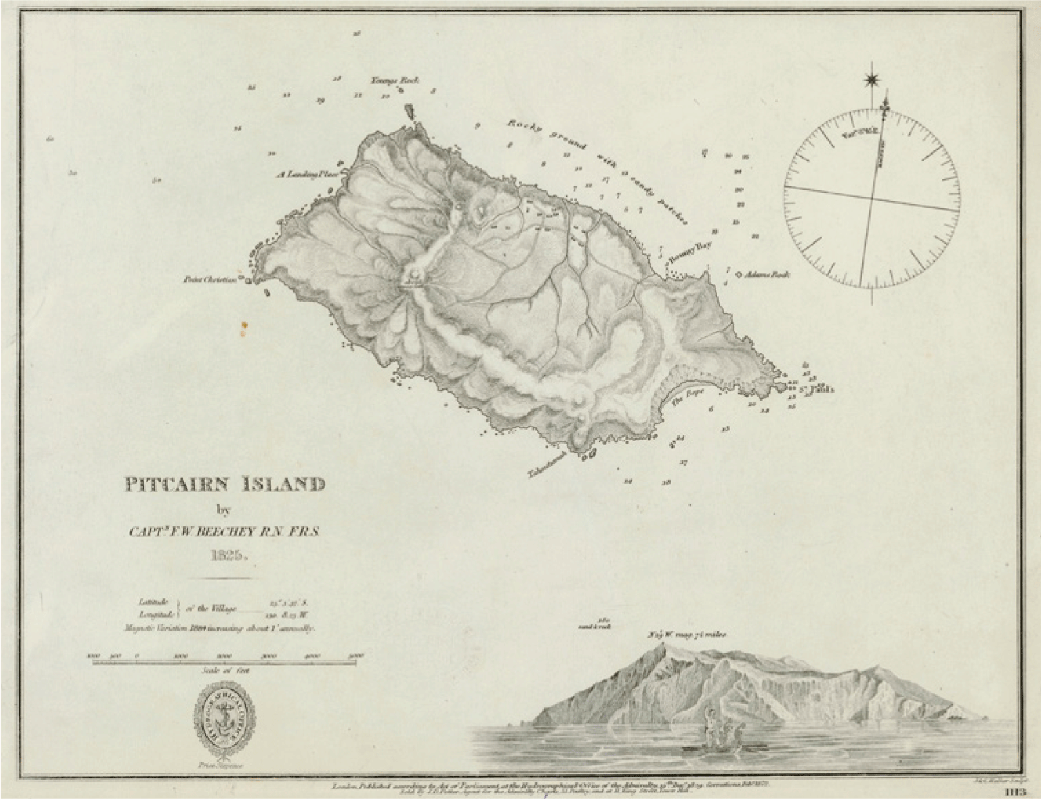
It took nearly two decades for news of the mutineers’ whereabouts to surface (fig. 1). In 1808, an American whaling vessel under the command of Matthew Folger stopped at Pitcairn and encountered a small settlement comprised of survivors of the Bounty’s last voyage and their descendants. Folger, like most subsequent early visitors to the island, marveled at the discovery of a seemingly devout Christian community of English speakers in such an isolated place. Details emerged only gradually about the intervening years of brutal struggle. Just three years after landing on Pitcairn, the Tahitian men, who had been subjected to regular abuse, rose up and killed five of the mutineers, including Fletcher Christian. In reprisal, all six Tahitian men were murdered. Following the suicide of another mutineer, two of the remaining Britons—John Adams and Edward Young—attacked and killed the third, a sailor named Matthew Quintal, in a last spasm of violence. By 1800, Adams, the last survivor of the Bounty’s crew, emerged as the undisputed head of a small but growing population. The American whaler’s crew found him ruling the settlement as a quasi-king, presiding over a community that Andrew Lewis describes as a “Biblical monarchy.”Footnote 16
Overlooking signs that Pitcairn was anything less than idyllic, the British public devoured publications about the island. Commentators celebrated the arc of redemption from faithless mutineers to pious Christians living in apparent “innocence, harmony, and peace” on their island paradise.Footnote 17 The attention brought a flood of material support in its wake. Royal Navy ships delivered supplies and supervised a brief, failed relocation of Pitcairn’s residents to Tahiti. Captains on patrol adjudicated island conflicts, evaluated threats to order, and shored up the political power of one or another aspiring island ruler. But there were no instructions from London to claim the island and no attempts by navy captains to plant the flag.
The situation seemed to change decisively in November 1838 when Captain Russell Eliott arrived on a routine visit aboard HMS Fly. Acting on a request from a group of islanders, the captain established a process to elect a “Magistrate and Chief Ruler” and issued a basic set of laws. The newly created office was filled by one Edward Quintal, who swore to “keep a Register of my proceedings, and hold myself accountable for the due exercise of my Office, to Her Majesty the Queen of Great Britain or her representative.”Footnote 18 Eliott did not declare the island to be a British colony, but his acts implied the possibility of British jurisdiction. The interpretation gathered strength over time and inspired later claims by historians, popular writers, and the British government that the captain had taken possession of Pitcairn for the Crown.
In London, despite such assertions, colonial administrators continued to treat Pitcairn’s status as unsettled. Writing in 1846, James Stephen, the influential permanent undersecretary of state for the colonies, mused that a remote island in the “midst of the Pacific” was of no “use to the Nation at large.” Stephen noted that the British navy regularly intervened in the lives of residents, “making them Presents, sending Ships to visit them, permitting Naval Officers to make a sort of code for their Government, & to appoint rulers over them.”Footnote 19 He urged a resolution to the contradictory impulses that paired continual meddling with official indifference, proposing that the British government convey the islanders to “the nearest British Colony” as a means of placing them squarely under Crown authority.
A century later and even after a series of legislative interventions, Stephen’s successors continued to harbor doubts about whether Pitcairn was British. In 1955, a thin file circulated in the British Foreign and Commonwealth Office following a request from the secretary of state for the colonies, Alan Lennox-Boyd, for clarification on the constitutional status of Pitcairn.Footnote 20 Since 1898, the file noted, the island had been administered by the Western Pacific High Commission, based in Fiji and overseen by a governor who doubled as commissioner and official in charge of a sprawling maritime domain. Two subsequent letters patent for Fiji, also cited in the file, described Pitcairn as a “dependency.”Footnote 21
Responding to the query about Pitcairn’s status, one official penned a note in the file suggesting that the British government might be “obliged to admit” that the island was a dependency, even though it appeared nowhere on the government’s list of territories with that status. Below that remark, a second official scribbled the word “awkward” and requested further clarification. A third, more confident official explained that “dependency” was a term with “no particular meaning or connotation in constitutional law.” The label was irrelevant, he added, since Pitcairn was not subordinate to Fiji and the island groups merely shared a governor. Well before Pitcairn was administratively linked to Fiji, he continued, it had acquired the status of a British settlement “within the meaning of the British Settlements Act, 1887.” The act extended Crown rule to places settled by British subjects that had “no civilised government” and had “become or may hereafter become possessions of Her Majesty.”Footnote 22 In 1898, the government had expanded the act to include Pitcairn.Footnote 23 Nothing had changed since then, the bureaucrats concluded; Pitcairn was clearly British.
Despite such confident assertions, doubts about Pitcairn’s status resurfaced in the case that came before the Judicial Committee of the Privy Council in 2006.Footnote 24 The appellants were six Pitcairn men who had been convicted of sexual assault and rape—charges stemming from a police investigation that had uncovered evidence of long-term, widespread sexual abuse of Pitcairn women and girls, including young children. Lawyers for the men asserted that Britain had no jurisdiction to try the case. The appeal, although ultimately rejected by the court, raised an intriguing set of arguments.Footnote 25 Highlighting the mutiny’s legal and political significance, the appellants argued that the Bounty mutineers had renounced national allegiance, becoming stateless pirates when they seized the ship. The ensuing violence, the lawyers pointed out, decimated the mutineers’ numbers, leaving a majority of “Tahitian women and their children,” who were clearly not British subjects, in possession of the island. Further, they argued, for nearly a century there had been no effort to “take possession by a ratification and acceptance of an unauthorized settlement.” By this logic, the appellants could not be prosecuted under British law. Lord Hoffmann disagreed, and in a terse judgment the committee cited as proof of British sovereignty the “executive statement [from the government] affirming [Pitcairn] to be part of the territory of the Crown.” Arguments to the contrary, the court declared, were “unthinkable.”Footnote 26
Historians have contributed to the long-running disputes about Pitcairn’s status. They have paid closest attention to the decades between first contact with the community in 1808 and its inclusion within the British Settlements Act at the end of the nineteenth century. Marshaling evidence for contrasting positions and injecting their own interpretations, most have emphasized the dramas (and dramatic personae) of shipboard discipline, mutiny, and intra-island power struggles.Footnote 27 The works that analyze interactions between the navy and the islanders often do so clumsily, imbuing both captains’ actions and islanders’ power grabs with more intentionality and greater effect than they in fact had, while missing their wider context. Some historians focus narrowly on the actions and personality of Joshua W. Hill, a dictatorial figure conventionally portrayed as a mad tyrant with an addiction to self-serving fabrication. Others interpret the actions of Captain Eliott as marking a moment when Britain seized possession or the islanders asserted their own constitution.
These events take on new meaning when we consider their role in suspending the island on the threshold of empire without resolving its status. The mutiny itself, the origin point for Pitcairn’s settlement, established a template for island power struggles. As the historian Greg Dening showed, the mutiny on the Bounty was an extended performance about defining legitimate and illegitimate authority.Footnote 28 In the mutiny’s aftermath, island actors continued to jockey for position in relation to local and imperial power. In an important 2018 study, Tillman Nechtman argues that Hill arrived on Pitcairn in October 1832 with a clear “sense of how to reform and refortify British imperialism around the globe” and ended up leading his own “mutiny and treason” by orchestrating an “illicit and unauthorized seizure of a British colony by a British subject from the British crown.”Footnote 29 But this story is too neat. Mutinies are as much about modifying power as they are about seizing it. As Hill tilted against British authority and acted as a petty despot, he was recalibrating empire-island relations, not severing them. Like other interlopers, he was also entering a crowded field in which imperial agents and locals confidently stated and frequently amended assertions of authority. The main effects of the process were ambiguity and irresolution.
The routine workings of the region’s interpolity legal order sustained the instabilities of rule on Pitcairn, and vice versa. Our interpretations of Hill’s play for power and Captain Eliott’s legal actions will reveal how they and other actors tweaked imperial legal circuits rather than trying to rupture or radically transform them. The project of extending archipelagic British power through periodic naval visits, together with islanders’ creative responses to these patrols, placed and kept Pitcairn in a position of uncertain sovereignty.
Projecting British Law in the South Pacific
The jerry-rigged British legal administration in the South Pacific conditioned legal politics on Pitcairn. The founding of a penal colony at Botany Bay in 1787 fueled demand for resources from nearby islands and spilled a motley, unpredictable assortment of merchants, whalers, ex-convicts, and missionaries across Pacific archipelagos. Their ventures chipped away at the East India Company’s monopoly over trade and commerce, defined in the company’s charter as stretching from the Cape of Good Hope to the Strait of Magellan.Footnote 30 Anticipating the need for a more effective legal mechanism, the British government’s 1787 instructions awarded Arthur Phillip, the first governor of New South Wales, limited jurisdiction in “all the islands, adjacent in the Pacific Ocean.”Footnote 31 There was uncertainty about whether this jurisdiction covered just British subjects or extended to others, and whether it applied only in places where the British could plausibly claim rights of discovery and possession.Footnote 32
Attempts to clarify the reach of British legal authority introduced new uncertainties. In a series of acts, Parliament sought to extend Admiralty jurisdiction over crimes committed beyond British territories. An 1806 act removed the requirement of sending to England for trial those accused of committing crimes on the seas or “in Places very remote.” Commissioners could be appointed to preside over trials for offenses committed in any “Haven, River, Creek, or Place where the Admiral or Admirals have Power, Authority, or Jurisdiction.”Footnote 33 In 1817, Parliament specified that British jurisdiction extended to murder or manslaughter committed by former or current crew members on British ships in Honduras, New Zealand, Tahiti, or “within any other islands, countries, or places not within his Majesty’s dominions, nor subject to any European state or power, nor within the territory of the United States of America.”Footnote 34 Officials in New South Wales had no clear idea how this jurisdiction worked. In 1796, the second governor, John Hunter, wrote to London that although he possessed a commission as vice admiral of the colony, he was “yet at a loss to know how a court of Vice-Admiralty is to be convened here for the trial of offences committed on the high seas.”Footnote 35 Further efforts at clarification included the New South Wales Act in 1823 and the Australian Courts Act in 1828, giving courts in New South Wales and Van Diemen’s Land authority to try British subjects accused of crimes on other islands. A handful of consuls were appointed and their authority extended to other territories and islands, some clearly specified and some not.Footnote 36 Overall, the greatest consistency in the jurisdictional setup was confusion.
In practice, this situation left the exercise of British legal authority across a wide swath of islands in the hands of navy captains. Most captains carried instructions to protect British subjects, and they were authorized to make on-the-spot assessments about whether limited interventions, including the use of force, were warranted. Technically, these actions were not judicial, but the captains were undoubtedly operating—some more enthusiastically and assiduously than others—as agents of law. They carried out investigations, convened ad hoc hearings, and delivered acts of reprisal and punishment. Required to report their actions to superiors, many captains became adept at using legal language to justify interventions, both to avoid reprimands from the Admiralty for sparking unrest and to advance their careers by burnishing reputations for skillful diplomacy and restraint.Footnote 37
In a parallel policy, the British government sent navy captains in search of local sovereigns. In bits and pieces, a vision was emerging of a regional order in which multiple sovereigns would administer law in ways that would favor British interests.Footnote 38 The project was hardly opaque to local rulers. They played European empires against one another by demanding protection from European navies and home governments when it suited them and by adopting strategies to postpone or oppose annexation. In some cases, sovereigns granted rights and territory to ambitious outsiders. For example, the Sultan of Borneo allowed the British trader Alexander Hare and his associate, John Clunies-Ross, to preside over Hare’s own micropolity at Banjarmasin; the men convinced British officials to ship convicts from Java to support their fledgling imperium in imperio.Footnote 39 A decade later, James Brooke turned an alliance with the Sultan of Brunei into a right to rule Sarawak. He then arranged a British appointment as governor of Labuan and used his recognition as agent to negotiate a treaty—never ratified by Britain—with the Sultan of Sulu.Footnote 40 Improvisational diplomacy held advantages for everyone. The British government could endorse acts by imperial agents but also disapprove if those agents had overstepped, or as conditions shifted. And regional sovereigns could appeal to the British government for protection without ceding sovereignty. These two dynamics—the empowerment of navy captains and the search for local sovereigns—would infuse politics on Pitcairn.
The first news about the settlement on Pitcairn came from American captains, but British officials soon dispatched navy ships to the island. In 1814, Thomas Staines (HMS Briton) and Philip Pipon (HMS Tagus) became the first British captains to reach Pitcairn. Impressed by Adams’ piety, they credited him with preserving Christianity and island order. Without Adams’ guidance and influence, Pipon wrote, “the Settlement in all probability [would be] exterminated.”Footnote 41 Such a positive response was by no means guaranteed. Adams was, after all, a mutineer, and Pipon and Staines might have arrested the island leader and taken him to London to stand trial.Footnote 42 Instead, the captains worked to buttress Adams’ authority. Their support stemmed in part from a wider fascination with this small community apparently living in harmony, free of the sins of their forebears. But Pipon and Staines’ actions also fit easily within the navy’s wider modus operandi in the region. In propping up Adams’ position, they followed a pattern of naval oversight without clear responsibilities.
Scholars have struggled to describe the parameters of the navy’s relationship with the island, suggesting that the Admiralty regarded Pitcairn as its “particular ward” or “particular charge,” or that captains became its unofficial “protectors and stewards.”Footnote 43 Such descriptions miss the wider context of multiform imperial legal oversight and intervention in the region. They also assemble a jumble of navy captains’ visits into something resembling consistent policy. If individual captains did not specify their relationship to the Pitcairn community, it was partly because they were extending the imperial circuitry already traced through navy patrolling and intermittent intervention.
“We Are English”
At their most basic level, the actions of successive British captains flowed from the view that Pitcairners were, in some clear way, culturally British. They pointed to the islanders’ knowledge of English, the prevalence of English surnames in the community, their practice of an idiosyncratic Christianity, and the presence of a white man as their ruler. Such perceptions were underpinned by the islanders’ aggressive self-presentation as British. When the American whaling captain Matthew Folger asked, “Who are you?” on arriving at Pitcairn in 1808, the islanders replied, “We are English.” Folger pressed: “How then are you Englishmen, if you were born on that island, which the English do not own, and have never possessed?” They responded by invoking patrilineal descent: “We are Englishmen because our father was an Englishman.”Footnote 44 Later captains remarked that Adams peppered religious services with declarations of loyalty to the Crown and that the islanders “prayed for their sovereign and all the royal family with much apparent loyalty and sincerity.”Footnote 45 Other observers picked up this thread, reporting that the Pitcairners “consider the King of England as their sovereign.”Footnote 46
The islanders’ active assertion of Britishness was accompanied by an equally forceful denial that they were Tahitian. Although the members of the small community were—with the single exception of Adams—either Tahitian or Anglo-Tahitian and preserved a mix of Tahitian and British cultural practices, they “vigorously contested any categorization of themselves as ‘black.’”Footnote 47 This posture was evident from the moment of the community’s rediscovery, when the islanders resisted putting on cultural displays for visitors with Tahitian themes. When one captain requested a performance of Tahitian dancing by the adult women, the islanders showed a striking reticence: “With great difficulty and much entreaty, the visitors prevailed on three grown-up ladies to stand up to perform the Otaheitan dance, which they consented to with a reluctance that showed it was done only to oblige them.”Footnote 48
Visitors delighted in finding signs of the cultural resilience—and therefore superiority—of Britishness in the community. On meeting Fletcher Christian’s son in 1814, Captain Pipon observed that the crew were “very glad to trace in his benevolent countenance all the features of an honest English face.” Marks of Englishness prompted in Pipon “feelings of tenderness and compassion.”Footnote 49 Staines described the community “as a very fine race of young men women & children” who deserved religious instruction.Footnote 50 The islanders’ familiarity became a frequent theme for visitors. In 1833, one visiting captain wrote that the islanders who arrived in canoes to greet his ship “were all well-dressed, and in every respect had the appearance of Englishmen.”Footnote 51
It is tempting to read such accounts as a prelude to British possession. But testimony about the Britishness of the islanders coexisted with a marked reluctance to assume administrative control. Here, as on many other islands across circuits of British patrolling, the main conduits of imperial policy were navy captains who stopped briefly and exercised impromptu legal authority. Charged with protecting British subjects and authorized to make on-the-spot decisions about the use of force—so long as they did not start a major war with islanders or other Europeans—navy captains on patrol projected British influence through ad hoc actions spanning investigation, judgment, and population management.
Map of the Pacific Ocean showing the location of Pitcairn
Source: John Arrowsmith, “Pacific Ocean,” in The London Atlas of Universal Geography, Exhibiting the Physical and Political Divisions of the Various Countries of the World, Constructed from Original Materials […] (London: J. Arrowsmith, 1842). Reproduced with kind permission of the David Rumsey Historical Map Collection, https://www.davidrumsey.com/maps860.html
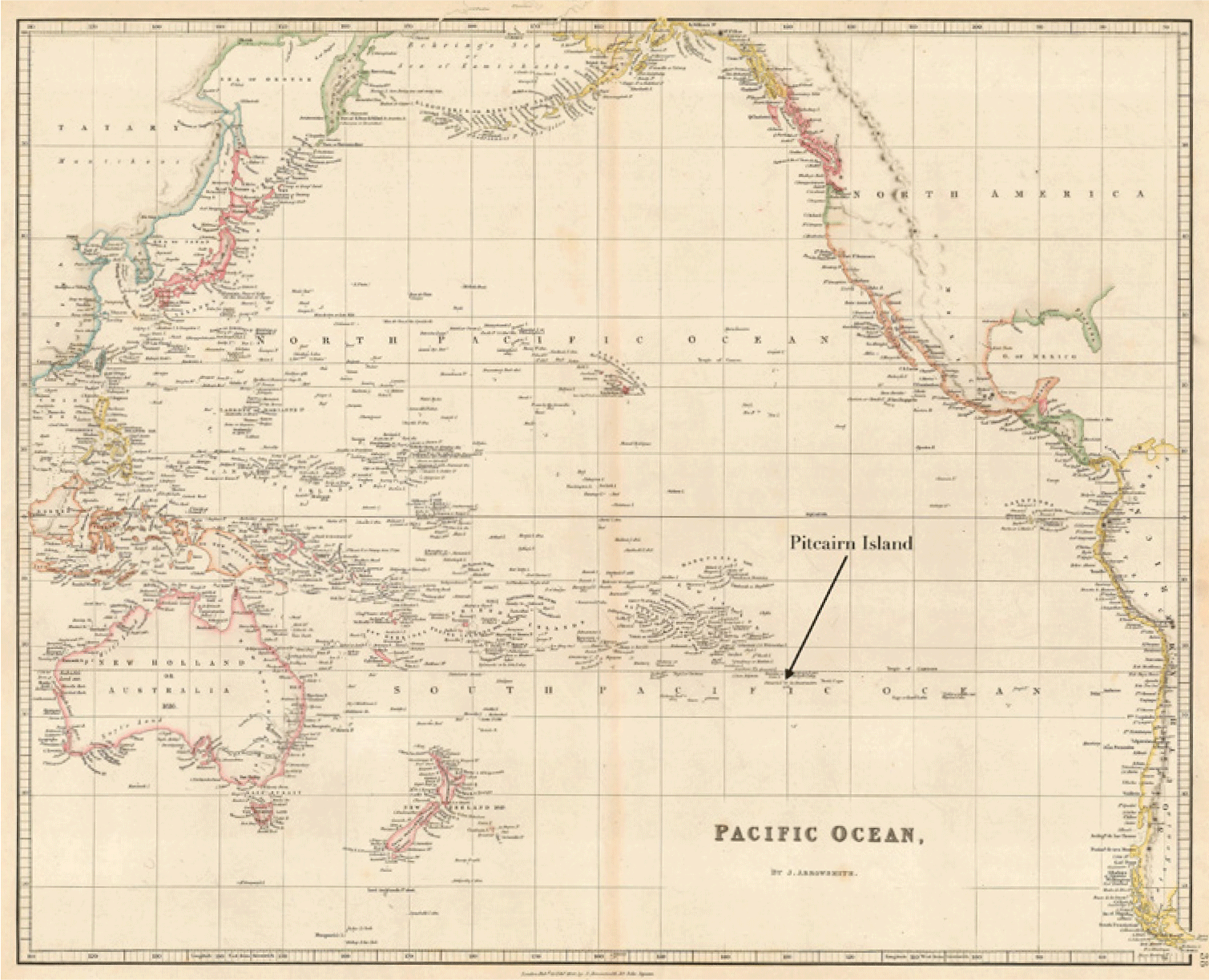
The clearest example of this sort of intervention occurred in 1831, when the Admiralty, acting on a request made several years earlier by Adams, organized the resettlement of the Pitcairners to Tahiti (fig. 2). By the time the Admiralty was able to arrange transport, Adams had died, and many of the inhabitants were reluctant to leave their island home. Yet the operation moved forward. In February 1831, Captain Alexander Sandilands was dispatched with HMS Comet alongside a colonial government barque, the Lucy Ann, to remove the islanders. The Admiralty never doubted its authority to resettle the population, even as it did not assume responsibility for them as British subjects. Instead, British officials pressured the monarch of Tahiti, first Pōmare III and later Pōmare IV, to take the islanders in and provide them with land and sustenance—and to accept them as Tahitians. Eager to secure British protection, the Tahitian government cooperated, but the move proved short-lived. Almost as soon as they arrived, the islanders balked at the idea of becoming Tahitian subjects and maneuvered to return home. Only a month after their arrival on Tahiti, a first contingent returned to Pitcairn aboard a schooner, and the remainder made the return voyage five months later.
The costly and unsuccessful resettlement depended on the navy’s assertion of legal authority, without actual claims of jurisdiction. For their part, islanders worked to retain their connections to the Admiralty, persistently appealing to captains for continued support while rejecting incorporation as subjects in Tahiti. Such tactics proved successful. Shouldering the burden of the costly, aborted move to Tahiti without protest, the British government showed no signs of abandoning the islanders after their return.Footnote 52
Island Rule, Island Law
It is impossible to detail the shifting relationship between Pitcairn and the British Empire without tracing the twisting path of intra-island rivalries and the strategies of leaders—some born on Pitcairn, some arriving later—who attempted to use British power to secure local power. Despite its image as a harmonious island Eden, Pitcairn was dominated by ferocious internal conflicts that sometimes shaded into violence. Interacting with islanders on periodic stops at Pitcairn, British captains entered into local politics, supporting competing bids for authority or reinforcing the legitimacy of one or another faction. Island rule required cultivating captains’ support, and island law took shape through an intricately managed but ad hoc process of limited intervention.
One focal point of controversy was the appointment of an island leader. On his deathbed in 1829, Adams had pleaded with the islanders to name a chief, but they could not settle on a single figure.Footnote 53 After his death, shifting alliances formed and reformed among the so-called native families, all with mutineer surnames: the Christians, Adams, Youngs, Quintals, McCoys, and Mills. Conflicts intensified under the influence of three British interlopers, John Buffett, John Evans, and George Hunn Nobbs, who arrived in the 1820s. Starting off as outsiders, these men became key players in the island’s sharp disputes, with Buffett and Nobbs targeting control of the school, the one institution to which all residents were required to contribute.
The interlopers began by forging connections to local families. Arriving in 1823, Buffett and Evans quickly secured their access to land by marrying Pitcairn women. Buffett married Dorothy Young, a member of one of the ruling families, and became the island’s schoolteacher, seizing leadership of the school and the public support that came with the position. In 1828, Nobbs arrived after stints in the British and Chilean navies. Better educated than either Buffett or Evans and clearly more ambitious, Nobbs rapidly emerged as a powerful figure. He married Sarah Christian, Fletcher Christian’s granddaughter, in 1829, effectively allying himself with the island’s most consistently influential dynasty. Evans, for his part, married Rachel Adams.
The new aspirants to power quickly identified the position of schoolmaster as one that carried significant authority. Unable to oust Buffett from the position, Nobbs established his own school, and the rival institutions, one with sixteen students, the other with eight, competed for influence. By 1830, Nobbs’ power was in clear ascendance as he claimed the title of “pastor, registrar, and schoolmaster.”Footnote 54 One visiting captain observed, “Nobbs claims exemption from labour as pastor; by law he is to be maintained by the community. His information is superior to the natives, therefore he wishes to become the chief.”Footnote 55 Nobbs’ position ensured support: the islanders were required to pay the schoolmaster one shilling per month regardless of whether their children were enrolled or not.Footnote 56
Nobbs’ rise triggered fresh alliances among rival families. A key competitor emerged in the figure of Edward Quintal. Traditional power structures on the island had been dominated by the members of families claiming links with three mutineers: Christian, Adams, and Young.Footnote 57 Quintal had a less exalted background. His father, Matthew, was an able seaman who had been murdered by Adams and Young in the final phase of violent struggle on Pitcairn in 1799. But the younger Quintal was ambitious and politically savvy, and by 1830 one visiting naval captain, William Waldegrave, confidently predicted that “Edward Quintal … will be chief.”Footnote 58 The challenge for Quintal was to displace firmly rooted habits of deference to a few families. The solution appeared in the form of yet another interloper, Joshua Hill, an aging English adventurer, captain, and self-declared philanthropist. Hill’s sojourn on Pitcairn was relatively brief but it activated new patterns of naval intervention and laid down a template that would be used by later aspirants to island rule.
Hill was in some ways typical of an ill-defined group of Pacific sojourners who came to the region aboard whalers and merchant ships or through transportation and desertion. Searching for opportunity, and after an extended stay on Tahiti, he landed on Pitcairn in October 1832.Footnote 59 Hill quickly began to rearrange the political landscape of the island, creating a new power structure formed of elders, sub-elders, and cadets with himself at the top as “pastor, teacher, and general superintendent and director of the natives.”Footnote 60 Although there were pockets of resistance, the bulk of the island’s residents fell into line with Hill’s new ruling structure. For decades, historians and popular writers insisted that Hill was a “mentally unbalanced” dictator who had succeeded only by deceiving an innocent community.Footnote 61 In his persuasive study, however, Nechtman dispels the image of Hill as a crazed figure with an unsteady grip on reality. As Nechtman shows, Hill introduced a string of reforms that were connected to wider “colonial concerns” and found consistent support among some native families.Footnote 62 He profited directly, too, from the system of quasi-rule by naval circuit as he courted and won the approval of navy captains at key moments in his contest over local rule.
Hill implemented a three-part strategy with each component energetically supported by Quintal, his most important ally and “right-hand man.”Footnote 63 First, Hill moved to empower local families against the interlopers, whom he derided as “profligate foreigners.”Footnote 64 Although Evans, Buffett, and Nobbs had married into local families and fathered multiple children on the island, Hill presented the men as opportunistic outsiders with no claim to authority and no rights to land. Petitions orchestrated by Hill and Quintal described the triumvirate as “three worthless fellows (runaway English sailors, whom, alas! we allowed to stop on the island).”Footnote 65 Drawing up new laws, Hill moved to endow local families with special status and exclude the interlopers and their children from land rights.Footnote 66 He also banned further marriages between local families and anyone connected with Evans, Buffett, and Nobbs, including their children. Hill compelled “genuine natives” as young as seven years old to sign a pledge stating they would never marry foreigners.Footnote 67
Hill’s second key strategy was to establish himself as a representative of the British government. His campaign contained an obvious contradiction. Even as he criticized the interlopers as outsiders with no legitimate authority over local families, Hill, a recent arrival himself, insisted that he was a different and more deserving object of navy support. In a letter addressed to the colonial secretary in December 1832, just a few months after his arrival in Pitcairn, Hill wrote to inquire whether “His Majesty’s government would not be pleased to nominate me its agent for good here.”Footnote 68 He assured the Colonial Office that his assuming this role “with the sanction and assistance of your Lordship” would “make of these natives one of the most happy people whatever.”Footnote 69 The choice of “agent” as his desired official role was telling. Hill wanted recognition from the government but not incorporation in the empire.
This strategy proved effective precisely because it fit the regional regime in which imperial agents acted in varied capacities for the British without being employed by the British government. Whenever navy captains arrived on the island, Hill repeated his demand for some sort of written recognition of his public authority. As Hill worked to pull Pitcairn more clearly into a British-dominated zone on the fringes of the empire, he angled for an exclusive, London-sanctioned position of authority for himself in which he would retain considerable autonomy. Such a move would have preserved Pitcairn’s ambiguous legal status while giving Hill clear authority over the island.Footnote 70
In a third crucial maneuver, Hill leveraged British naval power in his favor and angled to remove navy support from his rivals. He made authoritative-sounding claims about his influence with the British government, threatening islanders that if they opposed him, “he would cause a military governor to be sent out from England, with a party of soldiers, who would take their land from them and treat them as slaves.”Footnote 71 Hill also took concrete steps to shore up his authority by taking advantage of regular naval visits. He worked to cut off contact between the interlopers and arriving captains. When a vessel anchored at the island, Evans recounted, “two confidential men were despatched on board to forbid the captain and officers holding any communication with foreigners on shore; and we were prohibited, under pains and penalties, from going on board.”Footnote 72 In addition to restricting communications, Hill repeatedly invoked the threat of British naval power against those who challenged his leadership. According to Buffett, Hill told the residents that “if they did not obey him he would write to government and a ship of war would be sent to chastise them.”Footnote 73 He attempted to make good on these threats by moving aggressively to persuade individual captains to act on his behalf when they arrived at the island.
Hill’s strategy of empowering select local families, inserting himself in imperial hierarchies, and mobilizing British naval power could not be accomplished without support. He relied on a durable alliance with the Quintal family. Of the three Pitcairn elders who endorsed Hill’s rise, two, Arthur and Edward, were Quintals. They enthusiastically embraced Hill’s message that the island’s resources belonged exclusively to local families and not to the (other) interlopers. Edward Quintal wrote a flattering public petition begging Hill to stay on Pitcairn and imploring him “to accept our most sincere gratitude for all which you have done for us.”Footnote 74 Hill responded by heaping praise on Quintal as a “native of Pitcairns, the only one of veracity upon it left.”Footnote 75 For his part, Quintal clearly believed that he would receive British approval to succeed Hill in his position as de facto ruler of the island. According to observers, Quintal followed Hill “not from any love for him, but from his … promises of making Edward Quintal his successor.”Footnote 76
These swirling bids for influence by self-interested British sojourners and their allies presented new challenges for the system of glancing oversight by navy captains. Instructions called for the protection of British subjects—but which subjects? Were sojourner-subjects entitled to more support than Pitcairners of ambiguous status? How was a warship captain to decide which aspirants to power he should back? Even if captains could make informed, principled judgments about the best course of action, they possessed no clear pathway to the exercise of British jurisdiction beyond those measures judged on the spot to be necessary to island order. Clearly, none of these naval visitors regarded Hill’s rise to power as a mutiny. They treated his actions as fully consistent with the regime of improvised interventions that composed the legal circuitry of British naval power.
Jurisdictional Puzzles
If jockeying for local power depended on naval endorsement, it also activated a change in the navy’s role. Captain Charles Fremantle was the first to confront Hill’s new regime. He arrived aboard HMS Challenger in January 1833, just a few months after Hill had installed himself on Pitcairn, discovering this latest interloper and his allies pitted against Nobbs, Buffett, and their supporters. The result was a collision between factional politics and the navy’s modus operandi of limited intervention.
In a terse letter to his superiors reporting what had happened, Fremantle insisted that he had “arranged their little disputes to the best of my abilities” while also pointing—like so many other visitors—to the impossibility of obtaining the truth about events on Pitcairn.Footnote 77 Fremantle began his intervention by calling together the island’s residents and staging a public investigation.Footnote 78 As the process unfolded, he criticized Nobbs and Buffett for their supposedly pernicious influence on the island, including the seduction of young girls and the manufacture of spirits in improvised stills. Fremantle’s fiercest critique was directed at Nobbs, who was informed that he could no longer occupy the position of schoolmaster. By contrast, Fremantle praised Hill for having created a temperance society for islanders and for “restoring them to some kind of order.”Footnote 79
Such actions conformed to navy captains’ style of ad hoc legal intervention elsewhere in the region. But Hill lobbied Fremantle to go further. He wanted the captain to arrest Nobbs, Buffett, and Evans and transport them off the island. In letters written after the Challenger departed, Hill suggested that Fremantle had in fact taken this step. According to Hill, Fremantle had “sentenced these three men (three runaway common English sailors) to leave the island as early as possible; but, unfortunately for us, Capt. F. forgot to leave a line in regard to his orders.”Footnote 80 In his letters to the Colonial Office, Hill was more cautious and admitted that Fremantle did “not feel himself authorised to take off the three Englishmen.”Footnote 81 Fremantle knew not to be drawn into an exercise of jurisdiction that his superiors might not support. In his own dispatch, he explained that “he had recommended” that Nobbs “quit the island” but had taken no further action.
The limits to British interventionism were vague but real. While willing to intervene legally to protect subjects or preserve order, Fremantle was under instructions—like all British navy captains in the region—to avoid unilateral actions that would result in the acquisition of new colonies or trigger wider conflicts. There was some precedent for transporting British troublemakers off vulnerable islands, and captains on Pacific patrols had been cautioned about the “great numbers of worthless characters calling themselves Englishmen” who seemed so numerous in the Pacific.Footnote 82 In 1830 Captain Waldegrave of HMS Seringapatam had successfully arrested five Englishmen during a cruise through the Pacific, but such actions could quickly backfire. When Sandilands on the Comet made similar arrests in 1831, he had found his actions vigorously challenged in a court in New South Wales.Footnote 83 Captains carried no clear authority to sentence British subjects to transportation or exile.
The situation on Pitcairn offered fresh complexities, too. Nobbs might have been reprimanded as a drunkard imbibing home-brewed spirits, but he was also the island’s pastor and schoolmaster with his own web of supporters. And he was a British subject. Despite Hill’s relentless pressure, Fremantle was wary about overstepping boundaries. Although he concluded that Nobbs, Buffett, and Evans were sources of disorder, he refrained from punishing them.
Fremantle’s hesitation extended to political appointments. Hill insisted that he needed “written authority” or “public authority” to confirm his position on Pitcairn.Footnote 84 Although he did not use the word “agent” as he had done in his correspondence with the Colonial Office, Hill implied that he required some similar title so that he might properly protect islanders from contaminating influences. Fremantle accepted Hill’s logic that local families were in danger but had no intention of furnishing Hill with a formal title.
The factional conflict did not subside, even after Nobbs, Buffett, and Evans departed Pitcairn aboard a passing British whaler in March 1833. Writing from exile on Tahiti, they lobbied the British naval establishment in a relentless campaign of letters, while Hill and his allies responded with their own appeals for support.Footnote 85 The result was a war of petitions in which both sides claimed that naval authorities needed to intervene more aggressively to provide protection to the islanders in the face of rising danger. The recipients of these entreaties were two senior naval officials based in South America, Lord James Townshend and Rear Admiral Sir Michael Seymour, the commander-in-chief of the Pacific squadron headquartered at Valparaíso in Chile.
The competing claims that underpinned these petitions reveal a great deal about the imagined position of Pitcairn in relation to the British Empire. Nobbs, Buffett, and Evans complained that Hill was an impostor who falsely insisted that he was on a mission for the British government. According to Nobbs, “Mr. Hill had succeeded, by villainous misrepresentations, atrocious falsehoods, and magnificent promises of presents, to be obtained through his influence from the British Government and several British of Mr. Hill’s acquaintance, in ejecting your petitioner from his house.”Footnote 86 The men argued that Hill, who had seized all the firearms on the island, was a source of disorder in an otherwise peaceful community. Buffett lamented his own treatment at Hill’s hands and argued that the lives of not only “the English residents, but some of the natives, have been in danger from the malicious temper of Mr. J. Hill.”Footnote 87 British authorities must intervene, the men urged, to protect everyone against Hill’s nefarious influence, and from his violence.
Hill and his supporters were just as strident in calling for the navy to intercede and shelter them from harm. Hill wrote to Townshend requesting the navy’s “protection, in relation to certain evil designs which immediately concern [the inhabitants’] interest and welfare upon this island.”Footnote 88 In 1834, Hill’s key ally, Edward Quintal, sent a petition supposedly written on behalf of the “Principal Native Inhabitants of Pitcairn’s Island.” It demanded an official response to threats by Nobbs and his faction and described Quintal and other Pitcairners as British subjects in need of protection: “Your Lordship’s petitioners most humbly beseech and entreat your Lordship’s benevolence, thus protecting us all here under the British flag, as loyal subjects.”Footnote 89 The discourse of community danger was both convenient and flexible.
In the inter-imperial Pacific, it was always possible to point to threats posed by rival empire-states. According to Quintal, Nobbs and his allies had somehow arranged “an American brig with fifty-five men on board” in Tahiti for the express purpose of “coming to destroy” Pitcairn.Footnote 90 There is no evidence that such a threat was real, but it was effective enough that Quintal would recycle a variant in later years, claiming imminent danger from American whalers.
The conflict between Hill and the interlopers disoriented the British naval establishment. No one was sure whether Hill in fact held a position approved by the British government. John White, the acting consul general in Valparaíso, wrote to Rear Admiral Seymour expressing his uncertainty: “Whether Mr. Joshua Hill has any authority from His Majesty’s Government to interfere with the affairs of the island, I am not informed; but, knowing that His Majesty’s Government takes a warm interest in the welfare of these people of Pitcairn’s Island, I submit His request to your Lordship’s consideration, presuming that you have the power to exercise your authority in this particular case.” Seymour, also unsure how to respond, requested more instructions from Whitehall.Footnote 91
In the midst of this uncertainty, another visit by a navy captain marked a shift in support. On January 12, 1837, Edward Russell arrived in command of HMS Actaeon. He reported finding a divided island, split between Hill, with a diminishing group of supporters, and Nobbs, who had recently returned, together with his allies among the local families. Russell discovered “a great deal of animosity and bad feeling … existing between the two parties” and after an investigation concluded “that Mr. Hill had been the principal cause of all their dissensions.” In his report, Russell explained that “the majority of the people complained bitterly of [Hill’s] tyrannical conduct, and after I had undeceived them as to the authority he had assumed coming from the British Government, they all, with the exception of two Men, were anxious that he should be removed from the Island, and that Mr. Nobbs should remain as their Teacher and Schoolmaster.”Footnote 92 These final two allies were unnamed, but one was certainly Edward Quintal, who had consistently supported Hill.
Following the prevailing pattern of incomplete control and limited intervention, Russell held back from asserting jurisdiction. He agreed that Nobbs should stay on the island, although he expressed no great confidence in the former schoolmaster. But like Fremantle in 1833, Russell balked at passing judgment or ordering the removal of offenders. Instead, he encouraged Hill to leave voluntarily. As he later wrote, “I remonstrated with Mr. Hill upon his tyrannical conduct to these poor people, and desired him to give up his Church and School, and not to interfere with them again in any way: this he consented to, and promised to leave the Island, by the first opportunity.”Footnote 93 Russell opposed Hill, but he was clearly unwilling to arrest him or force him into exile. Eventually Hill departed as a free man aboard HMS Imogene in December 1837. Edward Quintal supported his ally to the very end, but he also learned from these events and used this knowledge in approaching the next British captain to arrive after Hill’s departure.
The politics surrounding Hill’s tenure on the island had exposed the circuits linking island and empire—and their limitations as instruments of power. The British government evidently had no intention of appointing a governor, an agent, or any other official with equivalent authority on Pitcairn. In keeping with their practice in the wider region, British captains were prepared to intervene in various ways but not to oversee criminal cases or order inhabitants into exile. It was also clear that—even within these limits—the navy’s interventions could be deeply consequential, especially for aspirants to local power. Captains’ actions were, by their nature, inconsistent and improvised. “Commodore justice” is perhaps too exalted a term for this practice of legal action on patrol and its frequent contradictions.Footnote 94 In an effort to protect the islanders from dangerous outsiders, Fremantle had condemned Nobbs and supported Hill in 1833. In 1837, just four years later and with the same basic goal, Russell had condemned Hill and supported Nobbs. It was clear to Quintal that the next intervention must be more carefully engineered, with appeals for protection from sharper threats and with pleas for more specific commitments.
Possession by Degrees
It was under these strained conditions that a British navy captain supposedly tipped the balance by incorporating Pitcairn into the empire. Historians have identified the actions of Captain Russell Eliott of HMS Fly, a small sloop mounting eighteen guns, on November 29, 1838, as marking a turning point in the history of island sovereignty. The visit began like any other: Locals skilled at maneuvering through the hazardous anchorage transported Captain Eliott and some members of his crew to the island. Then, after meeting with some of the islanders, Eliott took an unusual step and promulgated the brief “Laws and Regulations of Pitcairn’s Island.” These regulations, which Eliott pointedly did not describe as a “constitution,” included two components: a process for electing a magistrate and a code of laws with ten provisions related primarily to daily life and resources on the island.Footnote 95
While scholars, government officials, and legal practitioners agree on these facts, they differ widely in characterizing the significance of Eliott’s actions. Some state definitively that Eliott took possession of the island, which was “formally incorporated as a colony.”Footnote 96 In later years, British government officials would echo this interpretation. By the mid-1970s, the government would state categorically to the United Nations that Pitcairn “was annexed as a British colony” in 1838.Footnote 97 Other historians have described what happened very differently, portraying Captain Eliott’s lawmaking as a constitutional beginning for an independent people. For Linda Colley, the islanders were vulnerable “people with brown skin” who acquired “their own written constitution, and their own acting chief executive and democratic process”—all handed down by a benevolent and enlightened British naval officer.Footnote 98 A third group has argued that the islanders ceded their territory to Britain. Paul Dacre, the public defender in the Pitcairn case that reached the Judicial Committee in 2006, followed this view when he argued that Eliott had presided over the formal cession of an independent Pitcairn to the Crown.Footnote 99
What these approaches have in common is their analysis of Eliott’s visit outside the context of the fluid system of naval oversight. Besides the protection of imperial subjects and interests, captains were routinely instructed to accumulate evidence that might serve to support future claims of possession. Only on rare occasions were they dispatched to formally annex territories. Confident statements about Eliott’s annexation ignore the way that British captains supported inchoate claims to possession.
References to possession in European empires reflected the influence of Roman writings on the acquisition of private property. One Roman legal concept, occupatio, or occupation, indicated a means of establishing ownership over wild beasts and other things that had no owners. Occupation could lead to secure title, but its proofs were varied and open-ended. European imperial agents engaged in flag planting, mapping, founding settlements, staging acts of jurisdiction, and other symbolic acts as they amassed evidence in support of such claims. Although occupation stood in the background as a framework for acquiring territory, the notion that land could fall within the category of res nullius (things without owners) was slow to develop.Footnote 100 Occupation and possession were related but distinct modalities of acquiring property in Roman law. On one level, possession was like occupation in that it also required evidence, and the array of proofs was similar and could include founding settlements, building fortifications, making maps, and related symbolic acts. On another level, possession differed from occupation in that it conveyed rights based on a set of proofs merely superior to those presented by others. The bar was lower to establish territorial claims in this way because possession did not convey title; it merely recognized a better-supported bid for control.Footnote 101
Histories of the Pacific have often referred to claiming possession without recognizing the performative, cumulative nature of the process. Stuart Banner, for example, analyzes possession not as a broad legal discourse and practice but as a label for imperial control of land. This approach leads him to focus on how possession unfolded in different ways in diverse parts of the Pacific and on how local contests over land generated variable outcomes and timelines with regard to Indigenous dispossession.Footnote 102 But his emphasis on diverging trajectories shifts attention from the shared discourse of possession. Across the Pacific region, European imperial agents deployed symbolic acts to burnish claims to possession that empires might make in the future. Admiralty officials were acutely aware that the process was one of accretion—proofs of possession had to be collected, with no certain end—and they therefore instructed navy captains, including commanders of scientific expeditions, to seize opportunities to perform ceremonies of possession and to amass other relevant evidence when they could.Footnote 103 Officers who were seeking to cast their own actions in the most favorable light needed little convincing to collect signs supportive of possession. The flexibility of the process gave captains considerable room for maneuver, and they improvised accordingly. Their reports translated chaotic interactions in the Pacific region into an idiom of metropolitan aspirations. Possession talk was part and parcel of future-conditional empire.
Agreements about protection were another elemental part of the interpolity order of the nineteenth-century Pacific. Whether powerful or weak, polities had long found advantage in defining their relationships in terms of protection. Offering protection to a weaker political community did not necessarily equate to claiming authority or sovereignty over it. In fact, small or militarily weak polities also gravitated toward the language of protection because it left open, at least in theory, the possibility of altering the terms of the interpolitical relationship in the future, including withdrawing or shifting to the protection of another power. Although hardly new—protection arrangements were so ubiquitous that we can regard them as an element of the early modern global order—“protection talk” was especially salient in the diplomacy of the nineteenth century. European empires preferred offering protection to assuming the costs and responsibilities of new colonies, and political communities buffeted by powerful imperial rivals sought protectors as a way of preserving their autonomy.Footnote 104 Alongside these trends, commercial expansion prompted calls for the protection of merchants and merged references to imperial subjects and imperial interests.Footnote 105
Possession as a flexible, open-ended discourse and protection as a recurring touchstone for security arrangements—these repertoires were available and useful to Eliott on Pitcairn in 1838. He did not at any point state that he was writing a constitution or annexing Pitcairn. Instead, he activated symbols of possession without pronouncing it, and he affirmed British protection of Pitcairn Islanders without making a commitment to extending British administration or rule. Like other navy captains, Eliott was wary of overstepping his authority and worried that his superiors might find that he had engaged in overreaching. With these calculations in mind, he explained his actions as urgent and necessary responses to danger.
Eliott improvised, but his actions were consistently guided by the islanders themselves. When Eliott arrived, the residents of Pitcairn—now with ample experience of the vagaries of naval intervention—steered him toward their desired goals. At the center of the negotiation was Edward Quintal, who stood to benefit most directly from this latest intervention. Local leaders demanded that the captain take immediate action to counter what they presented as a serious threat. They informed Eliott of the danger posed by unruly crews of whaling ships and recounted one especially dangerous episode in which “half the ruffian crew of a Whale Ship were on shore for a fortnight.” The rowdy mariners “offered every insult to the inhabitants and threatened to violate any woman whose protectors they could overcome by force.” The desperate local men had to abandon the care of their crops to stand guard over women and children. Not satisfied, the American whalers had reportedly launched a political attack, deriding Pitcairn as a place with “no laws, no country, no authority” and mocking the claim that islanders were under the “protection of Great Britain, as [they] had neither colours, or written authority.”Footnote 106
The tale was dramatic and compelling, but there was no evidence to support it. Whaling crews did sometimes wreak havoc on isolated islands, but there is no record of such attacks on Pitcairn and far more evidence that the story was invented. Investigating the allegations three years after Eliott’s visit, the Admiralty found no sign of such a threat. In 1841, Captain Jenkin Jones of HMS Curaçao wrote to Rear Admiral Charles B. H. Ross, “I am pleased to be able to contradict the rumour of the Inhabitants of Pitcairn’s having been in any way molested, or ill treated by the Crews of Ships landing there. The assembled Inhabitants assured me that so far from such being the case they had been fairly, honestly, considerately, and kindly dealt with by all the Vessels.”Footnote 107 Records kept on the island are also silent about an attack. The Pitcairn Island Register, which detailed the arrival of each incoming vessel, makes no mention of such a dramatic episode, and there is no reference in any other contemporary source.Footnote 108 Two years later, after the Colonial Office had arranged to provide some weapons, the captain of the vessel carrying the muskets and shot reported that the islanders “expressed great surprise at its ever having been rumoured that Arms were required for their protection.”Footnote 109
Indeed, the only account of the whalers’ attack appears to have been the one presented to Eliott. Supported by this thin reed, generations of writers on Pitcairn’s history have accepted the tale of the marauding whalers as fact. Colley notes, for example, the threat of “predatory visitors,” and other historians uncritically repeat the unverified story told to Eliott.Footnote 110 Donald McLoughlin describes the “depredations of American whaling crews who were visiting the Island in rapidly increasing numbers.”Footnote 111 These accounts overlook the framework of navy-islander relations surrounding Eliott’s visit. That context makes it plausible—indeed, likely—that Quintal’s faction concocted the story of violence by American whalers to stir Eliott to action. It would not have been the first time that the islanders had used deception to present themselves as uniquely deserving of help.Footnote 112 Nor did telling tales to Eliott, as we have shown, mark the first time that a faction bidding for local power had sought to enlist the support of a navy captain to further their aims.
Taking islander tales at face value, historians have also failed to recognize Eliott’s interest in establishing his reputation as a competent, careful agent of British power. Writing to Rear Admiral Ross about his actions on Pitcairn, Eliott sought to reassure his superiors that he had not overstepped his authority or acted carelessly when, in a single day, he had presided over the election of Edward Quintal, sworn the latter in as community chief, and given the islanders a Union Jack.Footnote 113 His report is laced with subtle qualifications about these actions. He described the elected leader as a “Magistrate or Elder” and specified that he would be “answerable for his proceedings to Her Majesty’s Government for whose information he is to keep a Journal.” This reference to the mundane act of keeping of a journal appears intended to counteract the notion that the phrase “answerable … to Her Majesty’s Government” was the same as a claim of jurisdiction. Eliott sought to color the magistrate as more clerk than judge and remarked that his own measures on the island had amounted to nothing more than “a few hasty regulations.”Footnote 114 Eliott noted, too, that the island was already flying a Merchant Union Jack procured from a trading vessel; in his telling, he had simply given Pitcairners a better version of the flag. A skilled writer and able self-promoter, Eliott was cutting his actions down to size, fitting them to routines that Admiralty officials would recognize as business as usual on patrols. The idea was to support British geopolitical interests without changing the map, and Eliott knew better than anyone that he had carried no authorization to conduct a ceremony of possession on Pitcairn.
An even more crucial part of Eliott’s bid to burnish his reputation was the claim that he was extending protection. The captain himself embellished the story of the dangerous whalers, explaining that his goal on Pitcairn had been to adopt measures that would “best afford protection to these people, and least involve my Government.” The Pitcairners had represented the “immediate necessity for [there] being some chief or head to their increasing community … for their internal regulations and government, but more especially to meet the difficulties and dangers which they had already experienced and been again threatened with by lawless strangers in Whale Ships.” After describing the two-week assault by the “ruffian crew” and the ongoing threat implied by the whalers’ alleged taunt that the Pitcairners lacked proof of any ties to Britain, Eliott added, “I trust, Sir, you will consider my assumption of the power to confer this Authority was warranted by the Urgency of circumstances.” The captain was not asserting that Pitcairn Islanders were British. Rather he was using the logic of security to bring them under the (possibly temporary) protection of the Admiralty. Neither he nor Rear Admiral Ross would have doubted that the government could take the mantle of protection away as readily as he had extended it.Footnote 115
We are rather far from finding in Eliott’s actions either a ceremony of possession or the gift of a constitution.Footnote 116 On all counts, Eliott’s visit to Pitcairn fit (and perhaps slightly adjusted) the empire’s legal circuitry. A powerful faction with an ambitious leader manipulated a visiting captain to take sides in local politics and endorse one person’s authority on the island. It was a familiar pattern. The captain, meanwhile, drew on standard legal repertoires to push the boundaries of British influence without committing the government to rule or even guaranteeing security on a permanent basis. While this kind of cultivated ambiguity served nearly everyone’s purpose, implementing Eliott’s measures introduced some novel arrangements of power that were also, ultimately, amenable to the navy’s loose regime of oversight. The arrangements for political participation endorsed by Eliott did not upend the status quo, nor did they completely exclude outsiders. Although only native-born inhabitants could hold the position of community chief, anyone who had resided on the island for more than five years could vote to elect the magistrate. Not surprisingly given Quintal’s pivotal role, the system closely paralleled the political structures developed by Hill.Footnote 117 The magistrate would hear, rule on, and record complaints, while holding any suspects accused of a “grave offence or serious crime” and reporting them to “the Captain of any British Ship of War arriving” at the island.Footnote 118 The fact that the magistrate had to swear an oath to the queen and present a record of proceedings was the basis for later claims that Eliott had brought Pitcairn into the empire. But the oversight provided for in the code was gossamer thin—confined to an unpredictable annual visit that might stretch from a few hours to a few days and was readily open to manipulation. Although the magistrate was required to keep a “Journal or Register” recording all decisions, there was no specificity about the legal significance of that document—and there is no evidence that such a journal was ever kept.Footnote 119
After Eliott’s visit, some matters continued to be referred to visiting captains, who adjudicated a “few trifling quarrels.”Footnote 120 But other conflicts, including anything that might damage Pitcairn’s reputation as an island Eden and imperil the benefits of British protection, were kept under wraps by islanders. One perceptive ship’s doctor who arrived aboard HMS Curaçao close to three years after Eliott’s visit wrote: “We ascertained that some strifes and dissentions had sprung up and crimes appeared amongst them, although they were anxious to conceal the facts from us.”Footnote 121 It was of course perfectly rational for locals to conceal evidence of serious offenses to preserve the steady stream of gifts and provisions that in turn depended on maintaining their reputation for piety and simplicity. English captains reinforced the perception of risk, thundering that if Pitcairn Islanders “did not uphold this character, the English government and people would instantly cease to take any further interest in them.”Footnote 122
Back in London, government policy also perpetuated the status quo. James Stephen, the permanent undersecretary of state for the colonies, did not conclude that Eliott had established a stable framework for imperial law on the island. Believing the tales of aggressive acts carried out by American whalers, Stephen added his comments to Eliott’s report, noting that there was no obvious mechanism to provide more robust protection. Dismissing any notion that Eliott had in fact claimed Pitcairn, he advised his superiors that Pitcairn could not be incorporated as a colony, nor could an independent government be established there: “I confess I know not how anything can be done for the inhabitants of Pitcairns Island. It is impossible to establish an independent Govt. or Colony there, nor do I know how the Island could with any propriety be annexed to the Govt. of New South Wales, which has no sort of connection with it. Yet if neither of these measures be practicable, we are I believe at the end of all our resources.”Footnote 123 The island was too remote to be of any use to Britain. Stephen complained, “I cannot but think that this matter of Pitcairn’s Isle has been practically dealt with too much with reference to the Romantic and the Picturesque. Here are 119 persons living on a small Island in the midst of the Pacific, of no more use to the Nation at large, than if they were settled in the Interior of Africa.” Yet despite its isolation and poverty, Pitcairn was the subject of frequent intervention by the navy. In Stephen’s view, the “Settlement has been nursed as a kind of pet or favourite—an amusement in which a Nation can hardly indulge itself for any length of time without doing much [unmixed] harm.”Footnote 124 Pitcairn was not a colony, he fretted, and yet it was continually treated as a territory that might eventually be regarded as one. Stephen had expressed with precision the legal circuitry and its effect of fixing Pitcairn at the threshold of the empire.
On the island, meanwhile, control had shifted back to the native families and especially the Quintals. Edward Quintal passed the position of magistrate to his brother in 1839 but died unexpectedly in 1841, just as he had reached a high point of influence.Footnote 125 As the magistrate emerged as the fulcrum of island power, Nobbs’ influence receded. A naval visitor arriving in 1844 recorded that Nobbs’ school had been discontinued for at least a year; it no longer enrolled pupils and had fallen into disrepair. Nobbs retained neither “authorised authority” nor “moral authority” over the islanders.Footnote 126 The role of magistrate continued to give its holder significant authority in dealing with visiting captains, who still formed the island’s lifeline. One observer described the “constant communication and traffic with the Crews of English, French and American Whalers.”Footnote 127 When a ship arrived, it was now the magistrate who visited first and assumed control of any gifts or presents intended for the islanders.Footnote 128 The regime combined light oversight with local despotism and, as it later became clear, sustained an undercurrent of pervasive sexual violence. As Edward Quintal supposedly asserted a few years before becoming magistrate, “We are our own masters; we shall do as we like; no one shall control us.”Footnote 129 The navy did not exercise control; it traced and retraced conduits of power.
The routines preserving the possibility of imperial intervention alongside local rule proved surprisingly durable. Visiting British captains occasionally wrote to their superiors encouraging the government to do something to push the island into a clearer status. In 1844, Lieutenant Commander Henry S. Hunt of the ketch Basilisk was insistent that the government must intervene to provide a clearer political structure. He wrote to Rear Admiral Richard D. Thomas to “recommend strongly to Her Majesty’s Government that a Governor should be sent to the Island.”Footnote 130 The Colonial Office dismissed this suggestion out of hand, with William Gladstone, the future prime minister, critiquing Hunt’s suggestion as a “proposal to found a new Colony.”Footnote 131
In the 1850s, a project backed by supporters in Britain took shape to move the entire population of Pitcairn to the British colony on Norfolk Island. Endorsed by Nobbs, who had gained an influential patron in the form of Rear Admiral Fairfax Moresby, many islanders relocated. But once again, the government’s schemes were sabotaged when a contingent opted to return to Pitcairn and reestablish the community there. Unresolved questions about the political and legal status of Pitcairn Islanders traveled back with them.
Pitcairn Island law was a study in uncertainties. The legal framework that developed mirrored the navy’s conflicting imperatives: to provide protection, advance proofs of possession against other empires’ claims, and refrain from creating new colonial responsibilities. Eliott had gestured toward a legal code but stopped short, very deliberately, of asserting British sovereignty. British legal authority hovered between weak assertions of jurisdiction and the selective shoring up of one or another candidate’s bids for local authority. Eliott’s intervention was balanced so delicately between these options that it gave rise to an array of persistent, contradictory misinterpretations. Not just for decades but for centuries after an American whaler found the tiny, isolated community of Pitcairn, the island’s residents remained partly inside and partly outside the empire.Footnote 132
Pitcairn’s history has conventionally been told through the careers of a few larger-than-life characters—Adams, Hill, and Eliott in the early years—and a handful of morality tales: wicked mutineers who became pious Christians, a tyrant who hoodwinked a community, and an enlightened British commander who either pulled the island into the empire or engineered its birth as an independent, constitutional state. Looking closely at the island’s history reveals a less glamorous story, one that unfolded through the multiform legal politics of islander maneuvering and the uneven circuits of British naval oversight. The regime differed sharply from models of interstate relations, handbooks on imperial power, or projects of worldmaking. The label of “informal empire” captures something of the official reticence about taking control, but it obscures the decidedly formal nature of navy legal oversight. It also shifts attention away from islanders’ periodic insistence on imperial protection.
The history of this very small place reveals the workings of an uneven legal order built on circuits of law of flickering intensity. Navy captains and Admiralty officials performed imperial authority in intermittent engagements and amassed an inconclusive record of reports and correspondence about island politics. Inhabitants with their own jurisdictional aspirations and their own interests guided this system while cultivating other centers of authority. The imperial legal circuitry preserved sovereign indeterminacy, and subsequent efforts to find turning points of imperial incorporation distort the historical record.
The regime required improvisation and ex post facto bureaucratic rationalization. People living alongside and in the way of navy patrols grasped these requirements clearly. They expertly manipulated captains and maneuvered to extract support for local legal authority. The process has sometimes been missed because it did not generate a mappable matrix of local-global articulation. Multiform circuits involved impromptu arrangements of protection, incomplete claims to possession, experiments in jurisdiction, and inventive gambits for grabbing local authority.
We can locate imperial legal circuits and their influence in strikingly different political settings across the Pacific. In New South Wales and New Zealand, settlers used violence and an array of legal strategies to extend their authority, while also deploying imperial discourses of possession and protection.Footnote 133 Sharpening gender and racial divisions, together with jurisdictional conflicts, crossed different sites and forms of imperial governance, from the Indigénat regime in New Caledonia to the Anglo-French condominium in Vanuatu (New Hebrides) and the United States’ colonization of Hawaiʻi.Footnote 134 Inter-imperial competition intensified reliance on naval patrolling as a medium of imperial power, while Indigenous inter-island strategies guided political trajectories and decolonization into the next century.Footnote 135
In this “empire of variations,” uncertainties of sovereignty proved both influential and resilient.Footnote 136 The metaphor of “circuits” captures key dimensions of this uneven, incomplete, and improvisational pattern of imperial power and its projection in a regime extending well beyond Pitcairn. In parallel to islanders’ engagement in the constitution and reconstitution of island order and their manipulation of imperial sponsors, representatives of empire constructed regional legal authority through the movement of ships and the interactions of officials with islanders, subjects, and sojourners. Captains’ vague instructions, the circulation of flexible discourses of international law, and the transposition of ill-fitting administrative models from elsewhere—these conditions only heightened uncertainties and troubled institutional transitions. The history of one small community, born in mutiny and thrust into communication and conflict with outsiders, exposes the unsteady currents of imperial power and the global imprint of sovereign indeterminacy.


