Since its discovery more than a hundred years ago, the Río Bec region has been famous for its elaborate architecture, their finely cut-stone veneers, and their richly decorated façades. As many of them are still standing and in relatively good condition, the monumental groups they form has attracted the attention of mayanists since the earliest times, all of whom have been struck by the characteristics that make this area unique in the Classic period Maya lowlands (Adams Reference Adams and Ashmore1981; Merwin Reference Merwin1913; Ruppert and Denison Reference Ruppert and Denison1943; Ruz Lhuillier Reference Ruz Lhuillier1945; Thompson Reference Thompson1945). In the region shown at an intermediate scale in Figure 1, the triangular symbol typically used to signal an archaeological site actually corresponds to a rather small cluster of large buildings, here termed a “monumental group” (formerly “groups” or “architectural groups”), mainly to set it apart from clusters of minor house mounds (Nondédéo Reference Nondédéo2004, Reference Nondédéo2005). Conspicuous, elaborate architecture and relative building size do not entail that such groups formed settlements larger than minor house mound clusters. Each of them generally consists of fewer than 10 structures, most often multiroom, range-type buildings that are not necessarily arranged around patios or public spaces, a fact that invites us to discard the “courtyard group” term (Adams and Jones Reference Adams and Jones1981). Not sufficiently nucleated together to form a settlement of some size, they do not appear to be associated in space with differing, diversified buildings as is the case in “minor centers” (Fry Reference Fry and Sabloff2001; Haviland Reference Haviland and Ashmore1981; Taschek and Ball Reference Taschek and Ball2003). Scattered over extensive areas and relatively distant from one another (350 m on average), none of them qualifies as larger in terms of clustering, surface, or building volume to occupy the top of a local hierarchy with public and political prerogatives.
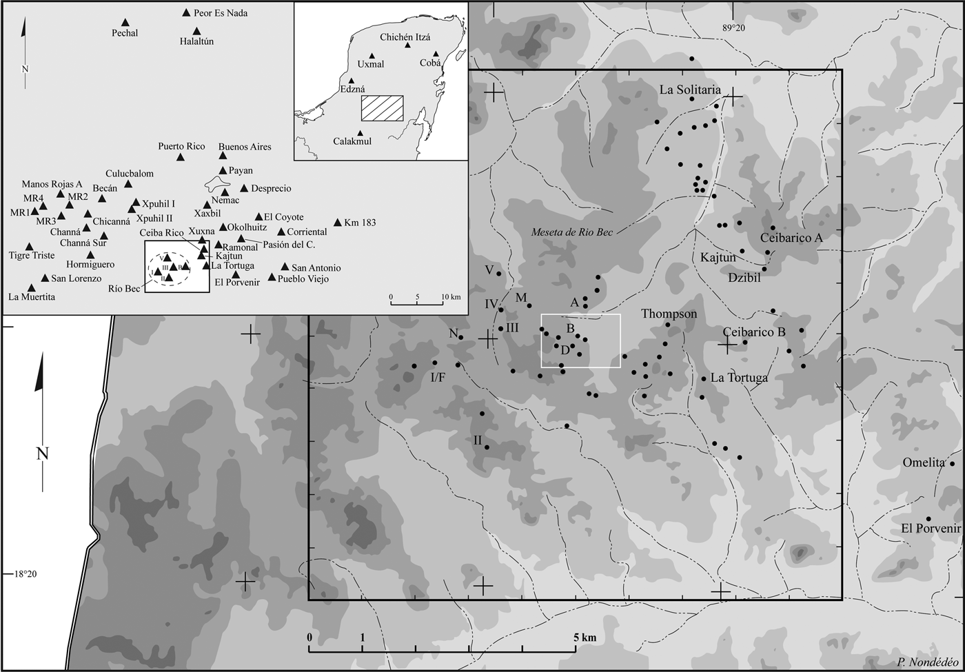
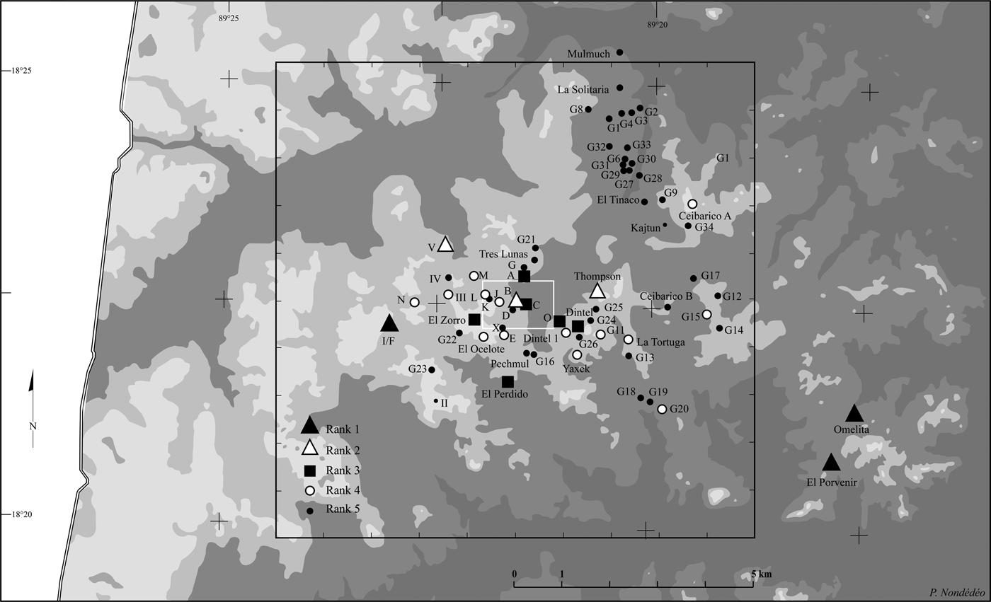
The Río Bec micro-region, covering 100 km² (black outline), and the 159 ha nuclear zone (white outline), with locations of the 73 monumental groups. The selected contour lines highlight the Río Bec Plateau (dark shade, 250 m asl), where most of the groups are located, contrasts with the unoccupied drainage zones (light shade, 200 m asl). Map by Philippe Nondédéo.

Even important groups such as Xpujil I and Hormiguero, which boast enormous buildings profusely decorated with truly massive components, are far from resembling a true “site” like we see at Becan, located on the northern fringe of the region (Figure 1). Becan was a complex settlement featuring a nucleated, well-delimited concentration of buildings of many styles, types, and functions (Potter Reference Potter1977). The site has also been considered as distinct due to its moat (Webster Reference Webster1976), its long sequence with an early occupation (Ball Reference Ball1977; Bueno Cano Reference Bueno Cano1999; Campaña Valenzuela Reference Campaña Valenzuela2005), and its unique location in a still largely unknown geopolitical context, possibly located at an early crossroad (Ball Reference Ball1977; Ball and Andrews Reference Ball and Andrews1978; Nondédéo et al. Reference Nondédéo, Patrois, Lacadena, Arnauld, Taladoire and Michelet2011). With the exception of Becan, however, the entire region shows no spatial concentration of either buildings or house mound zones reflecting a centralized power. All present clusters are small compared to other lowland Maya cities said to be organized in “groups,” including sites such as Uaxactun, Coba, or even Dzibanche, where the components are much larger and reflect multiple functions as suggested by pyramidal or administrative buildings and ball courts arranged around vast public plazas (Folan et al. Reference Folan, Kintz and Fletcher1983; Nalda Reference Nalda and Nalda2004; Valdés and Fahsen Reference Valdés and Fahsen1995). In contrast to the Río Bec groups, these multiple groups may have become epicenters and the seat of a ruling dynasty, performing either in temporal sequence (Uaxactun, Coba) or simultaneously with differing, specialized functions (Dzibanche) (Nalda and Campaña Valenzuela Reference Nalda, Valenzuela and Trejo1998).
Narrowing focus to the Río Bec groups proper, Adams (Reference Adams and Ashmore1981), following Merwin (Reference Merwin1913), questioned the nature of local settlement, which he saw as relatively different from those at other Maya centers for the same reasons outlined above. At that time, the groups' distribution in their environment and in the overall settlement pattern was poorly understood. By the 1980s, the “site” of Río Bec, an extended area of roughly 25 km², included two dozen monumental groups—a total that the Río Bec project has now increased to 73. It has little to do with the pattern of either Becan or of centralized cities like Calakmul or Oxpemul, located not far away to the west (Domínguez Carrasco et al. Reference Domínguez Carrasco, Tejero and Folan2010; Fletcher and Gann Reference Fletcher, Gann and Folan1994; Thomas Reference Thomas1981). Nowhere at Río Bec has a true concentration of large political and religious structures around vast public spaces been discovered, nor a true periphery or boundary marked by a decrease in the density of remains that would indicate a change from an “urban” to a “rural” context (Nondédéo Reference Nondédéo2005). Like their counterparts at the regional scale, the Río Bec monumental groups include few buildings, most of them with residential functions, scattered fairly regularly over several dozen square kilometers. Between them, minor residential units spaced at regular intervals are composed of a few mounds clustered to form a patio, and are more often than not informally arranged. The main differences between minor units and monumental groups are that the former have smaller built volumes and lesser complexity in the morphology of their mounds, while the latter boast relatively large multi-range and decorated buildings. Otherwise, all appear equivalent in layout, number of structures, and basic functions, as if the bigger units had grown in situ out of the smaller ones.
The original features of the Rio Bec settlement can be summarized as: (1) a dispersal over large areas of small clusters of buildings, in other words, an absence of nucleation among settlement units, (2) a limited variation in structure functional types within and between those units, (3) an absence of epicenter, that is, public and political spaces and buildings reflecting a centralized power, and (4) a marked hierarchy among groups and smaller units, yet only in morphology (style, size and elaborateness). The fact that some process of transformation did not accompany the growth of minor units into large monumental groups with elaborate architecture, such as diversifying functions and clustering built spaces, raises many puzzling questions. In this contribution, the main goal is to analyze the Río Bec settlement pattern in order to understand why nucleation processes did not occur around monumental groups, with lesser units agglomerating, new types of buildings being added, and complexity growing in internal/external ranking. Although Becan may have played a key role in the birth of the Río Bec phenomenon and architectural style, more diverse interactions with neighboring centers, including Becan, Calakmul, Oxpemul, Dzibanche, and El Palmar, have also been considered in the search for the origins of Río Bec settlement, but chronology has now led us to discard this line of inquiry (Arnauld and Nondédéo Reference Arnauld, Nondédéo, Van Broekhoven, Valencia, Vis and Sachse2010; Nondédéo et al. Reference Nondédéo, Patrois, Lacadena, Arnauld, Taladoire and Michelet2011). Instead, the Río Bec groups themselves must be analyzed diachronically, the large and the small units, in terms of structure types, internal layout, and hierarchy, in order to reconstruct some of the mechanisms that probably hindered the development of urbanization processes at Río Bec. Although difficult to build with an appropriate resolution (Taladoire et al. Reference Taladoire, Dzul, Nondédéo and Forné2013), diachronic development is the primary dimension of our analytical approach, as intra-settlement sociopolitical structures can be assessed archaeologically only if changes reflected in architecture are carefully controlled in time and space (Tourtellot Reference Tourtellot1988a, Reference Tourtellot, Wilk and Ashmore1988b).
The study of the peculiar Río Bec settlement pattern can shed new light on the social and political organization, not only of this atypical region, but also of the lowland Maya cities by the end of the Classic period. Nucleation—for example, emergent forms of urbanization out of small settlements that become increasingly dense over time and across space—is often postulated on the basis of local demographic growth, elite appropriation of commoner labor for construction, and rising socioeconomic interaction with neighboring centers (see Drennan Reference Drennan, Wilk and Ashmore1988; Dunham et al. Reference Dunham, Jamison, Leventhal, McAnany and Isaac1989; Feinman and Nicholas Reference Feinman, Nicholas, Arnauld, Manzanilla and Smith2012). Río Bec settlement patterns directly question these premises, and by the same token provide the opportunity to search for more detailed, practice-laden processes involved in Classic Maya social dynamics at a local scale. This can be said to be part of the general research on “rural complexity” (Iannone and Connel Reference Iannone and Connell2003). Moreover, if proper scales are used, settlement archaeology helps to contextualize the ruins in a specific environment, approaching some of its emic landscape features.
Two Río Bec settlement surveys were combined with extensive and intensive excavations at a multi-scalar level. Work spaces and scales of the Río Bec Project encompass first the “micro-region,” a 10 × 10 km2 area (Figure 1) in which the geometric center generally corresponds to the first discovered groups: Group A by Sapper and Group B by Merwin. This 100 km2 area was selected in order to study, in a larger context, what was called “Río Bec” at the end of the 1990s, corresponding at the time to two vaguely defined concentrations of monumental groups: one to the east including Groups A and B, and the other to the west including Group I, located roughly 2.5 km away (Carrasco Vargas et al. Reference Carrasco Vargas, Boucher and Peña Castillo1986). Second, in order to carry out a more intensive and in-depth study of general settlement patterns in an adequate space, we defined a smaller analysis unit, called the “nuclear zone,” centered on Group B, and covering 159 ha.
The micro-region scale is adequate to evaluate the evidence concerning political nucleation and internal organization. At what level can we detect local, emergent political powers, and did any of the monumental groups undergo an incipient nucleation process that would have leaded to centralized power? In turn, the scale of the nuclear zone provides the convenient window to reconstruct the basic social units composing monumental groups, and the lesser units as well. Adams (Reference Adams and Ashmore1981) observed that the Río Bec monumental groups must have represented multi-family households, but only in general terms. It remains to be established as to whether and to what degree the monumental groups structured regional settlement patterns by concentrating lesser units around themselves. In other words, as it had been stated in other regions (Puuc [Carmean Reference Carmean1991], Copan [Abrams Reference Abrams and Schiffer1989], and Mesoamerica [Hirth Reference Hirth, MacEachern, Archer and Garvin1989]), does architecture in Río Bec reflect the socioeconomic capacity of local groups to attract and mobilize the workforce of neighboring lesser units? We attempt, thus, to provide and discuss a series of data bearing on the issue of nucleation—politically on one hand, and socially on the other—while keeping in mind that separating both aspects is an arbitrary choice justified only by the geographical and spatial scales of the preliminary analyses performed (for discussion of different scales and perspectives see Arnauld et al. [Reference Arnauld, Michelet and Nondédéo2013] and Michelet et al. [Reference Michelet, Nondédéo, Patrois, Gillot and González G2013]).
Broadly stated, our methodology consists of analyzing the spatial distribution of settlement in relation to its internal hierarchy, while assessing as precisely as possible its evolution through time. The study was carried out at the two mentioned scales of analysis and the results are first presented at the scale of the micro-region (100 km2), and then at the scale of the nuclear zone (159 ha). Our contribution examines the groups' internal organization and composition, the role of the main buildings as the primary and critical expression of ancient groupings to be understood as “social houses” (see Arnauld et al. Reference Arnauld, Michelet and Nondédéo2013), and the evolution of their functions through time. At the 100 km2 scale, centrifugal forces were continuously operating across what is defined as the settlement periphery, yet effective nucleating trends can be detected late in Classic period times on this same periphery; at El Porvenir-Omelita to the east and at Group I to the west. At the 159 ha scale, the many scattered groups that shared a tightly managed agrarian landscape competed for space and social power, with a few high-ranking houses forming allied pairs that helped stabilize social and agrarian rivalries, relegating new stem groups to areas beyond the margins. These differing processes—nucleation, centrifugal forces, alliances, and intermittent splitting—basically structured the settlement at large during the Late and Terminal Classic periods.
BACKGROUND: RÍO BEC AS SEEN BEFORE 2002
At the beginning of the 1970s, Adams and his colleagues (Reference Adams and Adams1975, Reference Adams and Adams1977; see also Eaton Reference Eaton1972, Reference Eaton1975; Thomas Reference Thomas1981; Turner Reference Turner1983) undertook the Río Bec Ecological Project, just before Seuffert (Reference Seuffert1974) relocated Group B. Like Ruppert and Denison (Reference Ruppert and Denison1943:5) had done previously, Adams (Reference Adams and Ashmore1981:220) observed the “looseness of organization” of the largest groups. In addition, he (Adams Reference Adams and Ashmore1981:227–230) remarked on “the great numbers of ruins […] between the recorded groups.” At the time, however, access to, and survey of, the region was difficult, and it was still possible to believe that the largest Río Bec groups belonged to a nucleated center not yet discovered. More interesting is Adams' (Reference Adams and Ashmore1981:217) reflection on the monumental courtyard group[s] that he recognized as “natural or emic unit[s] within Maya ceremonial centers,” of the same nature as the “small rural and house-mound groups.” This led him to distinguish two hierarchical categories: the “smaller groups, built by private means for private domestic purposes,” and the “monumental groups built for private use by the ruling classes, and for public community purposes, using community resources.” It was therefore implied that the groups with standing architecture included private buildings and public, or community buildings. Even though we doubted the existence of a center in the Río Bec micro-region when we began our own research project in 2002 (Nondédéo Reference Nondédéo2003), we shared Adams's sense of mixed, private/public functions for the largest buildings. But, as Thomas readily acknowledged after his 1976 excavations of the famous building in Group B (Thomas and Campbell Reference Thomas and Campbell2008), even the largest structures proved to have basically residential functions. After eight fieldwork seasons (2002–2009), we are still skeptical about the existence of true public functions in the largest groups after the Early Classic period (except perhaps in Group V). Differentiating private from private-public functions and buildings had other important implications, as Adams (Reference Adams and Ashmore1981) conceptually extended the divide to include construction techniques, adducing that private-public buildings in large courtyard groups are those “which would require formal architectural skills, a mass of manpower beyond the extended family level, and access to material mass beyond that needed for minimal housing purposes.” Adams (Reference Adams and Ashmore1981:227; Adams and Jones Reference Adams and Jones1981:313–314) also believed that some temporal factor was involved. To summarize, Adams articulated a functional, as well as technical and temporal perspective to reach the conclusion that large private-public buildings integrated some kind of community center and were built by many people in a relatively short time when compared against the Peten site sequences. The research results obtained by the Río Bec project tend to show that large private residential units were built each by an autonomous small group of people in a time span longer than a small patio unit, and that no public center ever formed locally from the time that the Río Bec phenomenon was established (a.d. 550–1000).
MICRO-REGIONAL AND ZONAL SURVEYS: A DUAL-SCALE APPROACH
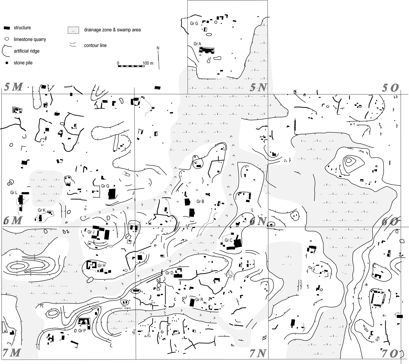
In order to characterize the Río Bec settlement patterns at two complementary scales of analysis—the “nuclear zone” of 159 ha and the micro-region of 100 km2—specific methods of data acquisition were employed. At the nuclear scale, an image as complete as possible of the occupation was sought by way of a systematic survey carried out in a rectangle 1,500 m east-west by 1,000 m north-south centered on Group B, and later extended 300 × 300 m to include Groups A and G (Figure 2). The survey consisted of footpaths along brechas, spaced 15 m apart over a grid made up of 100 m north-south brechas (staked every 50 m) cut into the forest. This allowed for the identification and mapping of anthropogenic features within each hectare unit, including a majority of those linked to ancient agriculture. A total of 501 mounds were recorded, 333 of which were identified as remains of dwelling structures, most of them clustered in small residential units. The remaining features were functionally mixed—the result of domestic activities, construction, and/or farming (see Lemonnier and Vannière Reference Lemonnier and Vannière2013).
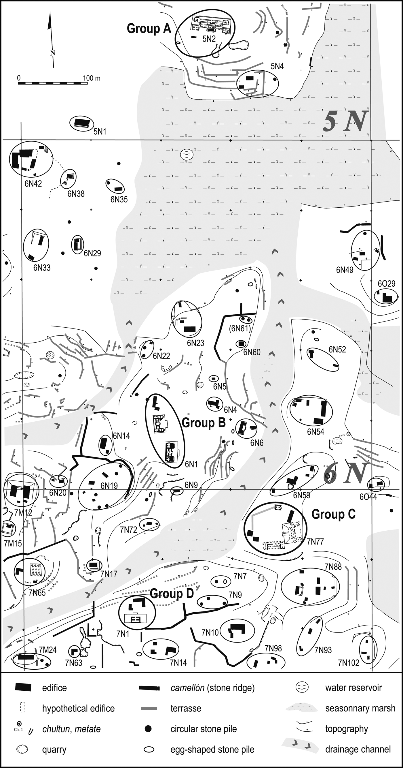
Map of the 159 ha nuclear zone centered on Group B, a 1 × 1.5 km rectangular survey zone with a 9 ha northern extension. Settlement units are distributed on the “interfluves” delimited by seasonally drained channels. To enhance visibility, terraces have been excluded; see close-up in Figure 7 for a detailed map including terraces. Map by Philippe Nondédéo, Dominique Michelet, and Eva Lemonnier.
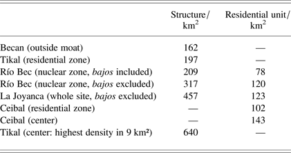
The image obtained is that of a dispersed settlement, with a regular density of residential units and isolated structures distributed among the monumental groups. The Río Bec settlement patterns can be classified as “rural” due to the absence of a monumental epicenter, but also, and above all, because of its agricultural infield system organized around each unit or group (Lemonnier and Vannière Reference Lemonnier and Vannière2013). The landscape appears to determine the location of units, with the main constraints identified at this scale being drainage channels and flooded zones (bajos) that circumscribe interfluves or relatively level and slightly elevated “peninsulas” that were occupied, whereas steeply sloped hills and rocky outcroppings were not (Nondédéo and Michelet Reference Nondédéo, Michelet, Berger, Bertoncello, Braemer, Davtian and Gazenbeek2005). Across this landscape, the 333 recorded residential structures represent an average density of 209 structures/km2, a relatively low figure if one considers that the nuclear zone exhibits the highest settlement density in the micro-region (see below). This figure increases to 317 structures/km2 if we exclude the sectors deemed unsuitable for settlement (58.87 ha; including areas of drainiage chanels, flooded zones, steep hills, rocky outcroppings, etc.). These results are average compared to high densities recorded in other lowland sites (see Table 1). To summarize, the nuclear zone settlement density is intermediate, that is, far lower than at major centers, but higher than the residential zones at those same sites.
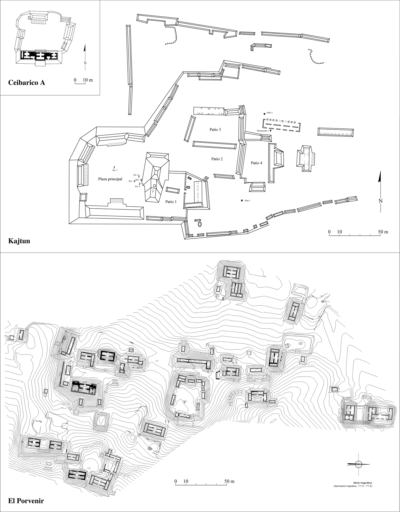
Ground plans of a patio group (Ceibarico A); a site with a plaza (Kajtun); and an informal group (El Porvenir). Plans by Philippe Nondédéo and Céline Gillot.
Comparison of structure and residential unit densities per square kilometer across lowland sites. Sites include: Becan (Thomas Reference Thomas1981); Ceibal (Tourtellot Reference Tourtellot1988a:22); La Joyanca (Breuil et al. Reference Breuil-Martinez, Lemonnier, Arnauld and Ponciano2004:74; Lemonnier Reference Lemonnier2009:189); Río Bec: the Río Bec project; and, Tikal (Carr and Hazard Reference Carr and Hazard1961:10; Puleston Reference Puleston and Hammond1974:308; Reference Puleston1983).
At the micro-regional scale, survey and analyses concentrated on monumental groups considered to be likely places of power, as our research goal was to reconstruct the sociopolitical organization of Río Bec society. Once these groups were located, their composition, internal spatial organization, and relative rank were determined to provide a broader context for interpretation of the nuclear zone. Additionally, we sought to locate the potential limits of the settlement identifying a significant decrease of monumental group densities. A semi-systematic survey combining local informants' information with a series of additional exploratory transects controlled by global positioning satellite (GPS) was undertaken (Nondédéo Reference Nondédéo2004). Approximately 60% of the micro-region was satisfactorily covered, except for the southern fringe and the northwest quadrant, both major drainage zones periodically flooded where construction must have been limited, and where potential discoveries would not significantly alter the overarching settlement scheme. Also, through a major program of stratigraphic test pitting in sampled groups, an architectural and stylistic sequence was established on the basis of collected chrono-ceramic data (Nondédéo and Dzul Reference Nondédéo, Dzul, Castillo and Vargas2010; Nondédéo and Patrois Reference Nondédéo, Patrois, Monod-Becquelin, Breton and Ruz2010; Taladoire et al. Reference Taladoire, Dzul, Nondédéo and Forné2013).
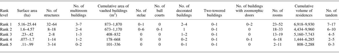
According to the survey results, the micro-region includes 73 monumental groups, of which 25 had previously been recorded (Carrasco Vargas et al. Reference Carrasco Vargas, Boucher and Peña Castillo1986; Merwin Reference Merwin1913; Périgny Reference Périgny1908; Ruppert and Denison Reference Ruppert and Denison1943; Sapper Reference Sapper1897; Schmidt Reference Schmidt1981; Sulak Reference Sulak2001; Thompson Reference Thompson1936). The majority of these 25 “historical” groups had never been correctly located on a map and include Merwin's Groups A–G, Ruppert and Denison's Group I–V, and Carrasco Vargas' Groups H–N and R, along with five of Merwin and Thompson's attributed “sites,” including La Tortuga, El Porvenir, Yaxek-Las Escobas, and Ceibarico A and B. These latter five sites were originally distinguished from Río Bec because of their distinct labeling and supposedly more distant location, yet once relocated, they fit within, or close to, the limits of the micro-region, and form part of what is now called the Río Bec archaeological zone. Of the 73 groups, 38 were mapped in detail, whereas field sketches were made for other 17. To define their construction and occupation sequence, or at least that of their main residences, 35 groups were sampled in the test pit program (88 test pits in total) (see Taladoire et al. Reference Taladoire, Dzul, Nondédéo and Forné2013). One of the salient results of the survey is that among the 52 recorded buildings with standing architecture, 10 include towers, seven have roof combs, and 28 exhibit decoration on their façades (Nondédéo and Patrois Reference Nondédéo, Patrois and Benavides2007, Reference Nondédéo, Patrois, Monod-Becquelin, Breton and Ruz2010).
SPATIAL PATTERNS AT THE MICRO-REGIONAL SCALE (100 KM2)
The location of the monumental groups on the landscape, including their layout and internal composition, are analyzed in order to qualify their spatial distribution before tackling the rank-ordering task. The Río Bec micro-region consists of a large plateau, which is oriented southwest-northeast and is deeply dissected by several valleys created by rainfall runoff (Figure 1). On this plateau, at an average altitude of 250 m asl, a series of hills culminate at 280 m asl. This contrasting landscape, though with only moderate altitude changes between hilltops, middle slopes, and low flooded zones, was preferentially settled at mid-height on the plateau (46 out of 73 groups). On the periphery of Becan, Thomas (Reference Thomas1981:5–6) also noted a preference for flat or gently sloping areas for occupation. A second location type (27 out of 73 groups) corresponds to low-lying zones along the course of seasonal waterways, but in slightly raised sectors protected from flooding. Generally speaking, while proximity to aguadas does not seem to play a role one way or another, a position on the edge of the plateau or along a seasonal arroyo seems to have been preferred. What was probably at stake was easy access to bajo zones, a rich ecosystem with a variety of resources, including wet edges well adapted to growing crops as we still see in modern times. As suggested by Peterson and Drennan (Reference Peterson and Drennan2005:6–7), proximity to good soil patches must have been an important factor in determining the location of dwelling units.
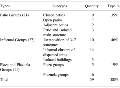
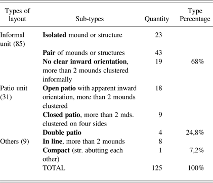
Each group includes a limited number of monumental buildings, associated or not with lesser structures, altogether forming residential units. Although the number of structures per group varies from 1 to 64, 73% (43 out of 59 well-documented cases) are made up of less than 10 structures each, all of which are considered small-sized monumental groups. Medium-sized groups (11 of 59; 19%) have from 10 to 20 structures, while the few larger-sized groups (five; 8%) contain more than 20 structures each. Monumental groups also vary in their spatial configuration (Figure 3). Table 2 shows that all patio groups together represent only 35% of the sample, whereas a few groups (19%) are organized around a central or open space larger than a patio, which confers them a public (plaza) or semipublic (plazuela) aspect. Distinguishing plaza groups from plazuela groups in the sample under study is mainly based on the calculation of the surface area of open constructed spaces in each group: patio groups have a shared space covering 156–604 m2, plazuela groups 1,250–1,517 m2, and plaza groups 3,444–5,175 m2 (for comparison with the Becan periphery see Thomas [Reference Thomas1981:108], and with the upper Belize Valley see Ball and Taschek [Reference Ball and Taschek1991:157]). But the most frequent type of layout (46%), which is probably characteristic of that region, is the informal one. It consists of either an isolated building, a few contiguous structures (three to seven) with no particular organization, or an informal cluster of dispersed residential units (up to 64 structures). The latter subtype can also be described as a scattering of patio groups or informal residential units close to one another and repeated over large areas which, in this case, makes the Río Bec settlement a paradigmatic example of fractal growth (Brown and Witschey Reference Brown and Witschey2003:1623–1624). In contrast with many central lowland sites, the informal type does not include only low-status residences (for example, groups of two-to-four low house mounds or platforms) (see Becker Reference Becker and Sabloff2001:263; Liendo Stuardo Reference Liendo Stuardo and Stuardo2008; Tourtellot Reference Tourtellot1988a), but also contains large concentrations of structures including major buildings, so that formal/informal layouts do not appear correlated with the number of grouped structures, or with the buildings architectural and decorative elaboration. For example, the five largest groups (more than 20 structures each) with the widest extent (5–25 ha) are not plaza groups, but rather informal clusters of dispersed residential units, such as Group I, Omelita, Porvenir, and El Zorro, all of which include very elaborate buildings. The only exception is Kajtun (63 structures, with several quite large), that is organized around a large plaza with adjoining patios, yet founded in the Middle Preclassic period with a florescence in the Late Preclassic and Early Classic periods—an early and long occupation period that would likely explain the presence of this unusual configuration in the micro-region (Nondédéo and Lacadena Reference Nondédéo and Lacadena2004). In contrast, the frequency of informal layouts among Río Bec clusters probably resulted from much shorter periods of development during Late Classic times, when trends toward division and dispersion must have been dominant. This also suggests that earlier occupation (see Taladoire et al. Reference Taladoire, Dzul, Nondédéo and Forné2013) seems to have been as sparse as it was scattered, thus hindering further development into a nucleated settlement pattern.
Types of spatial layouts among Río Bec monumental groups (100 km2, all periods)
Indeed, analysis of the micro-region's monumental groups must consider chronology. The phenomenon of Río Bec architecture and the residential system takes off around a.d. 550 (Nondédéo and Dzul Reference Nondédéo, Dzul, Castillo and Vargas2010; Taladoire et al. Reference Taladoire, Dzul, Nondédéo and Forné2013). Regionally, it succeeds an earlier pattern related to the central lowland tradition as defined by large central plazas, politico-religious buildings, and erection of stelae (Nondédéo Reference Nondédéo2003, Reference Nondédéo2005). Dominant during early periods in the Río Bec region as a whole (from the Middle Preclassic through Early Classic periods), the central lowland tradition is locally well illustrated by Kajtun and Group II, both of which are organized around a central plaza bordered by temple-pyramids. Around a.d. 550, however, Río Bec society adopts new modes of spatial organization and new types of buildings in response to new political, social, and cultural conceptions, while simultaneously discontinuing the older tradition. It is thus necessary to clearly distinguish pre-Río Bec settlement forms (600 b.c.–a.d. 550) from those at the apogee (a.d. 550–950), which is the reason why Kajtun and Group II are excluded from the present analysis—they pertain only to the earlier central lowland tradition. Additionally, both were, in great part, abandoned by the time of the florescence of the Río Bec groups, or were subject to brief reoccupation episodes that are still poorly defined.
All monumental groups have at least one “main building;” a large, generally multiroomed house that would have lodged several families under the same roof, with tandem rooms that would have allowed for the reception of visitors in the front room (see Arnauld et al. Reference Arnauld, Michelet and Nondédéo2013; Michelet et al. Reference Michelet, Nondédéo, Patrois, Gillot and González G2013). As both residence and seat of power of the local elite, and involving both residential and political functions, each of these buildings probably developed ritual functions that were previously reserved for temples, as expressed by the frequency and omnipresence of cosmic monster iconography on the buildings (Nondédéo and Patrois Reference Nondédéo, Patrois and Benavides2007, Reference Nondédéo, Patrois, Monod-Becquelin, Breton and Ruz2010). They were likely envisioned and/or considered as “noble houses” (emically and etically) (see Arnauld et al. Reference Arnauld, Michelet and Nondédéo2013). Notwithstanding their social importance in the group, they did not necessarily occupy a central position within them, as some were situated on the margins as if pushed out from the patios, or even semi-isolated. This would suggest that the great houses were not the focus of a centralizing process at the local level. They did not play the same structuring role in settlements as “main residences” did elsewhere in the central lowlands patio groups (Ashmore Reference Ashmore and Ashmore1981; Haviland Reference Haviland and Sabloff2001; Hendon Reference Hendon1991). A centrifugal trend is thus apparent even at the micro-local scale of the group. At the greatest extreme, Groups A, M, and La Tortuga have only one large, multiroom building (from 7–13 rooms) with towers, likely representing the highest rank in the hierarchy. In such large residences several families would have been concentrated after having previously been lodged in smaller houses located close by. This solution of concentrating kin or neighbors appears to differ radically from the “natural” growth process in dwellings successively built around one patio, as interpreted elsewhere in the Maya area (Haviland Reference Haviland and Ashmore1981, Reference Haviland, Wilk and Ashmore1988). This is a fundamental and unique aspect of the Río Bec phenomenon—that is, a social concentration in one single building often constructed out of the patio or on the edge.
The great houses vary in size and morphology (Figure 4). Rather simple (from 1 to 3–4 rooms) in the early phase of the Río Bec tradition (Kanlol phase a.d. 550–700), they contain increasingly more rooms through time, with up to 10–12 rooms in the second half of the Late Classic and into the Terminal Classic period (Makan [a.d. 700–850] and Xpuhuk [a.d. 850–950/1000] phases). They take on new functions at this time, such as hosting meetings (for example, Group O and the Thompson Group) that required the creation of new spaces within (Nondédéo and Patrois Reference Nondédéo, Patrois, Monod-Becquelin, Breton and Ruz2010). In a dozen of the most important groups, from two to seven large houses are present within one group (two to three on average). The increase can be explained in different ways: for example, according to the ceramic seriation, at Yaxek-Las Escobas, the three great houses (Structures 1, 4, and 5) spaced approximately 30 m apart, were used in sequence (Taladoire et al. Reference Taladoire, Dzul, Nondédéo and Forné2013): Structure 1, a tandem building in a private patio, was occupied from a.d. 550–650, followed by Structure 5, with three adjacent rooms and one transverse room on each side, being occupied from a.d. 620–690; and, finally, Structure 4, a tandem building with an integral zoomorphic doorway on its east façade, was inhabited from a.d. 760 until abandonment at roughly a.d. 820. In the three buildings, the relatively short occupational sequences with nearly no overlap suggests a succession in space and time of the seat of power moving from one residence to another. We reiterate here that, despite the investment of material and labor in their construction, each building had been occupied briefly. Interestingly, Group V offers a similar case where, in the early Terminal Classic period, a Late Classic period multi-range building, Structure 4 (well-known for its graffiti), was replaced by a new palace, Structure 5, and largely covered by a massive pyramidal substructure that was never finished.
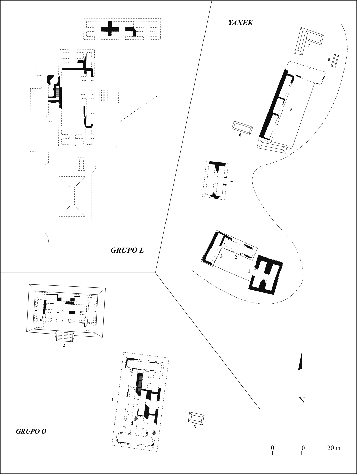
Some examples of the association between multiroom buildings sharing distinct functions in Group L, Yaxek-Las Escobas, and Group O. Drawing by Philippe Nondédéo.
Other multiroom buildings functioned in pairs, a typically late configuration by which residential and political, semi-public functions previously combined in one single house were then shared between two buildings—seen, for example, in Group L, Group B, and the Dintel Group. In other cases (Group O and Thompson Group), residential and ritual functions on the one hand, and meeting functions on the other were separated, the latter signaled by the addition of a hall, or open gallery, with pillars between multiple doorways in the façade (Arnauld et al. Reference Arnauld, Michelet and Nondédéo2013; Nondédéo and Patrois Reference Nondédéo, Patrois, Monod-Becquelin, Breton and Ruz2010). Clusters of semi-dispersed residential units illustrate a more frequent layout with several large houses sharing the same space and, thus, probably allied (Groups I, Omelita, El Porvenir). It appears to reflect a late trend toward settlement nucleation previously unknown. All these transformations provide clues to changes in the social organization of the groups, and a plausible evolution in the exercise of powers previously held by one family chief, then shared by several leaders in allied families. The change suggests shifts in the status and role played by the social houses over time that should be better understood.
Analyzing the spatial distribution of the 73 groups over the 100 km2 micro-region enables us to approach the internal political organization of Río Bec. Adams, followed shortly thereafter by Carrasco Vargas and colleagues, were the first to ponder the issue. Adams (Reference Adams and Ashmore1981:230–231) considered Río Bec to be a single, coherent site despite its “unintegrated” aspects, which he correlated with Rank I of his site hierarchy, placing the site on the same organizational level as Uaxactun or Ceibal, and higher than Becan, which he considered a Rank II site (Adams and Jones Reference Adams and Jones1981:305). In contrast, Carrasco Vargas and colleagues (Reference Carrasco Vargas, Boucher and Peña Castillo1986) defined Río Bec as consisting of two distinct clusters/sites—one focused around Group B and the other around Group I—and resting 2.5 km apart, exactly as Becan and Chicanna do. Our own work instead suggests that at the peak of the Río Bec development, no clearly nucleated center can be identified in the micro-region. None of the 73 groups stands out for its size, morphology, or its buildings, nor does any show significant nucleation at its periphery. This does not mean that there were not attempts by some groups to assert themselves as superior and to attract a resettled population, but they all seem to have “failed.” As mentioned, Group V acquired a true public plaza with carved stelae erected at the beginning of the Terminal Classic period, yet such a public statement of rulership does not seem to have fostered the growth of surrounding groups, nor attracted a population to resettle locally. The emergence of Group V does not coincide in the micro-region with any abandonment or decrease in the activities of other contemporaneous groups, which in fact reached their highest number at the end of the Late Classic (Taladoire et al. Reference Taladoire, Dzul, Nondédéo and Forné2013).
The average distance separating the monumental groups is approximately 350 m, but ranges vary from 150 m to slightly more than 1,000 m. The proximity of groups suggests face-to-face interaction among the families occupying them. At the same time, this proximity must have favored architectural emulation, or even competition amongst the most important social houses (Arnauld et al. Reference Arnauld, Michelet, Vannière, Nondédéo, Lemonnier, Arnauld, Manzanilla and Smith2012). At the micro-regional scale, a statistical nearest-neighbor analysis indicates the existence of two concentrations of groups—one central, the other eastern—stretched along a northwest-southeast axis (Figure 1) and separated by an empty area approximately 1,000 m wide corresponding to a drainage zone. In each concentration, sectors definitely present a higher density of groups: roughly six groups/km2, most apparent around Groups B, C, and D, the Thompson and Dintel Groups, and Groups G27–G33 situated to the north of El Tinaco. Yet, neither those sectors, nor the two concentrations can be assigned any political significance. Greater density of groups and topographic unity would qualify the central concentration as a sort of epicenter, but no gradual decrease in groups' density and in structure elaboration appears to delimit this supposed epicenter, as elsewhere in most other central lowland cities (Fletcher et al. Reference Fletcher, Hau, Folan and Folan1987; Fry Reference Fry and Sabloff2001). Where the spatial distribution of the Río Bec groups show a break (to the northwest, west, and the south), topography alone appears to be the primary limiting or prohibiting factor to human settlement in those areas. In contrast, the settlement is continuous to the north/northeast of the micro-region, connecting with another cluster of groups that formed the core zone of El Ramonal, and to the southeast joining the large groups of El Porvenir and Omelita. The latter belong to yet another cluster, the core of which would be located well beyond the limits of the micro-region.
HIERARCHY OF RÍO BEC GROUPS AT THE MICRO-REGION SCALE (100 KM2)
Here we demonstrate that the groups' hierarchy built for the micro-region supports the assertion that there was no true spatial and functional “epicenter” or “central place,” yet, plotting the rank ordered groups on a map allows a “settlement core” to be defined. This “core” is located at the heart of the central concentration identified above. The rank ordering is based on 12 criteria applied first to the 30 groups with the most complete information, and excluding those pre-Río Bec components (Groups II and Kajtun). In a subsequent but separate procedure, 32 additional groups were ranked on the basis of available data.
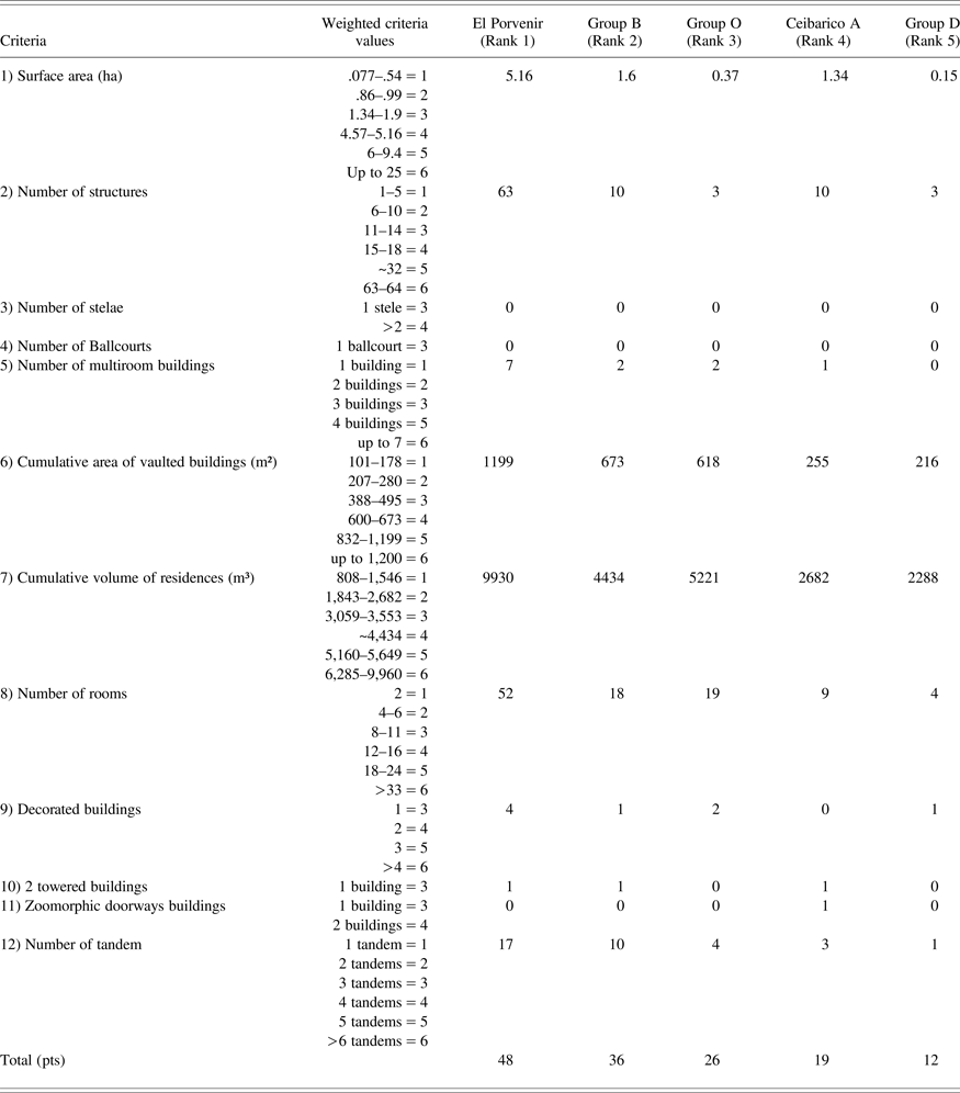
After evaluating Adams' method of rank ordering of the Río Bec monumental groups (Adams and Adams Reference Adams and Adams2003; Adams and Jones Reference Adams and Jones1981; see also Brown and Whitschey Reference Brown and Witschey2003:1623), we selected four criteria for assessing the sociopolitical relevance of each group; surface area and total number of structures measure the capacity to attract a large population, while the presence of stelae and ballcourts have political significance. Eight additional criteria reflect more specifically the characteristics of the Río Bec dwelling system, including quantitative assessments directly related to the inhabitants' socioeconomic power. These criteria include the number of multiroom buildings, the cumulative area of vaulted buildings, total number of rooms (excluding kitchens and storage rooms), and cumulative volume of residences. Also included were criteria more qualitative in nature and exclusive to the Río Bec region such as the presence of towers on buildings, zoomorphic doorways, and the number of decorated buildings present. By their theatrical nature, the latter emphasize the high social and political status of the families dwelling in such residences (Arnauld and Michelet Reference Arnauld, Michelet, Monod-Becquelin, Breton and Ruz2010; Arnauld et al. Reference Arnauld, Michelet and Nondédéo2013; Nondédéo and Patrois Reference Nondédéo, Patrois, Monod-Becquelin, Breton and Ruz2010). A final criterion, the total number of rooms organized in tandem within a group, measures the dwellers' ability to receive visitors, with the front room being adapted for reception.
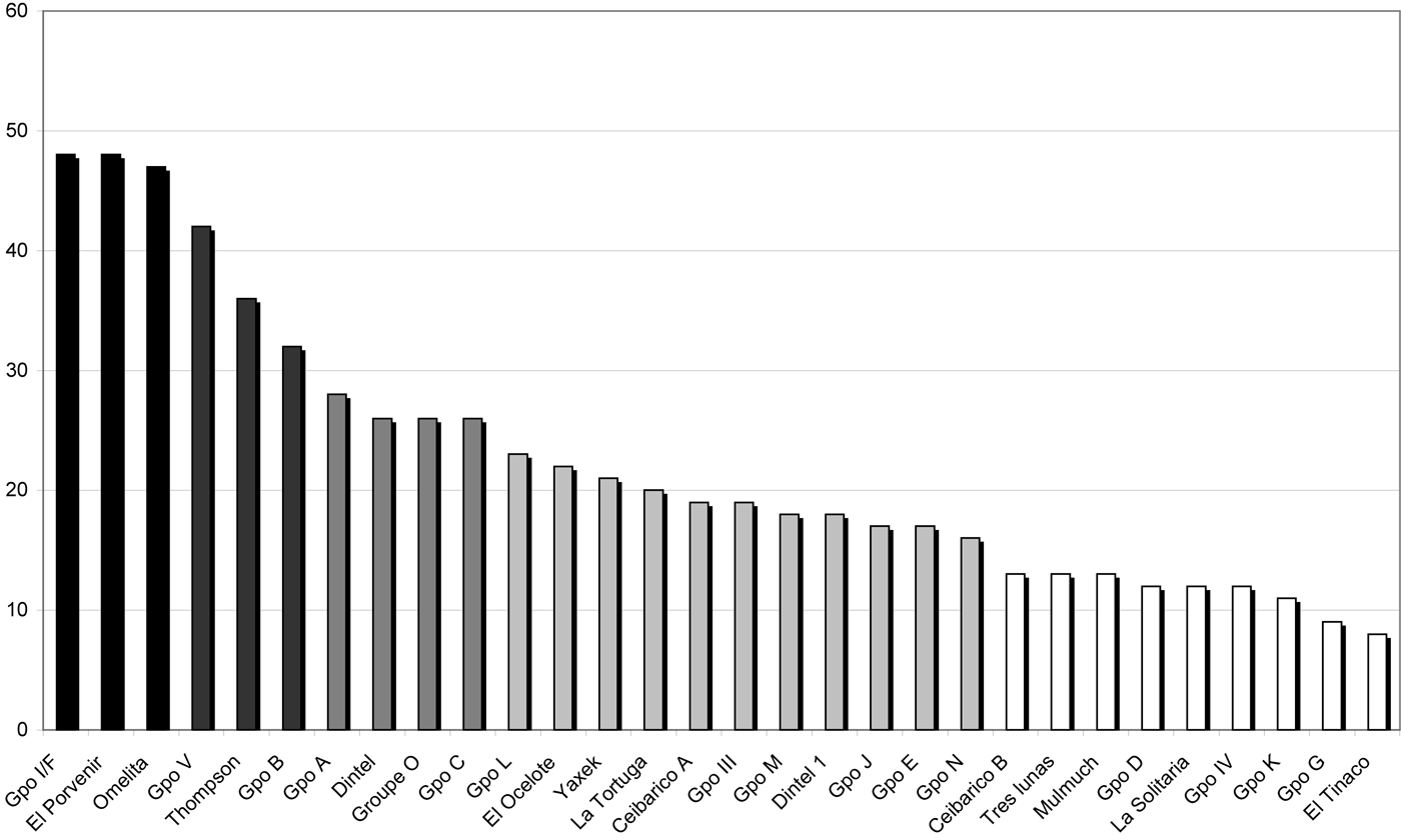
Table 3 provides examples of total scores attained by a sample of low- and high-ranking groups. The histogram in Figure 5 illustrates the rank ordering of the selected groups according to their individual score, devised through summation of the 12 criteria discussed above. This allows us to distinguish five ranks, clearly defining three distinct groups together in Rank I and three groups in Rank II, with the latter exhibiting more heterogeneous characteristics. Ranks III, IV, and V are less clearly discriminated (with four, eleven, and nine groups, respectively). In Table 4, when looking for the traits most effective for discriminating ranks, we see that the criteria “building with towers” or “zoomorphic doorways” are less significant than “number of multiroom buildings,” “cumulative area of vaulted buildings,” and “number of tandems.” Group surface area and total structures exhibit values that, overall, decrease from one rank to the next, though anomalies are present due to the priority given to building quality (over surface or structures total) in a group. For example, with only three structures—among which two are decorated multi-roomed buildings on high platforms—Group O (Rank III) occupies approximately .37 ha, yet it ranks higher than Group G (Rank V) with 14 structures covering almost 1 ha , but featuring a main undecorated house with only two rooms on a low basal platform. This is in agreement with the Río Bec settlement system, which tends to concentrate coresidents under the same roof in large houses (Group O) instead of several contiguous small dwellings (Group G). Otherwise, as expected, and in spite of their political relevance, stelae and ballcourts do not distinguish top-ranking groups. For example, Group V ranks second with six stelae (all dated from the Río Bec apogee) and a ballcourt. As mentioned, however, it also lacks a significant concentration of population, suggesting that local attempts to build up effective rulership “failed.”
Rank-order of 32 selected groups in the 100 km2 micro-region. Chart by Philippe Nondédéo.
Weighted criteria (first two columns on the left) and value of scores per criterion for five representative monumental groups per rank in the Río Bec micro-region (100 km2)
Variation range of criteria by rank among 32 Río Bec groups
Chronologically, although all groups occupied throughout the Río Bec phenomenon (a.d. 550–950) were taken into account, the established hierarchy is valid only for the site apogee (approximately a.d. 850)—that is, the transition from Late to Terminal Classic phases (Makan 2-Xpuhuk 1). We know that the three highest-ranked groups—Group I, Omelita, and El Porvenir—developed strongly towards the end of the Makan phase (a.d. 800–850) and peaked in the first part of the Xpuhuk phase (a.d. 850–900). In the general evolution of Río Bec settlement patterns, a new process of population concentration within a few groups that emerge without any apparent precedent defines the ninth century. Founded late in a vacant space with no earlier structures or occupations detected, these three groups are clearly bounded by a periphery totally devoid of structures. This is in sharp contrast with (among other sectors) the nuclear zone, where all monumental groups are scattered amidst a regular continuum of minor units. The rapid increase in monumental architecture shown by the ninth-century groups, multiplying great houses built on higher basal platforms, certainly required more abundant labor than most groups had in previous times (Nondédéo and Patrois Reference Nondédéo, Patrois, Monod-Becquelin, Breton and Ruz2010). Among the latter, only three groups (B, V, and Thompson—the latest founded in the Kanlol phase) developed continuously through the end of the Late Classic period, a long process that elevated these groups to Rank II, but not quite to the top rank. Among them, Group V, although insufficiently documented, tends to rank statistically closer to the Rank I groups, whereas Group B, although intensively excavated and known in detail, appears closer to Rank III.
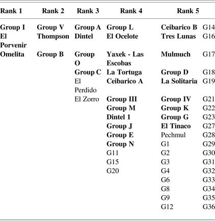
Once the ranking criteria was applied to the 30 best-documented groups and validated, 32 additional groups were also ranked following the same classificatory procedure. Rank ordering of the 62 groups is presented in Table 5 which, in turn, serves as the basis for the distribution map shown in Figure 6. The highest-ranking groups are located neither in the central concentration, nor in the eastern one, but somewhat far away to the east and the west on the margins of the Río Bec plateau where they were founded late in the chronological sequence and in extant, semi-vacant sectors/locations (see above). At the micro-regional scale, this reflects an extraordinary centrifugal tendency operating across the entire settlement. The three Rank II groups distributed equidistantly from one another were founded earlier and they in fact illustrate an earlier hierarchy dating to just before the peak of the Rank I groups. The groups in Rank III, morphologically more diversified, have a distribution on the Río Bec plateau that clusters within a circle 2.5 km in diameter, a pattern that can be identified as a “core in the settlement.” These late-founded groups were likely subject to strong competition as a result of being located so close to the zone of highest settlement density, which may have severely limited opportunity for growth. With regard to the Rank IV groups, their location further reinforces the identified core zone (except for Ceibarico A, G15, and G20, which reflect centrifugal forces). Like their Rank III counterparts, Rank IV groups present much variation in their morphology, and many of them were founded late: Groups N, III, and M to the west, E and El Ocelote to the south, and La Tortuga to the east, while many others developed along the edge of the central sector, as if this marginalization was the only way for them to grow far from the powerful houses settled earlier. This relative distancing perhaps explains why four of these groups (N, M, La Tortuga, and Ceibarico A) were able to construct their own buildings with towers, while the Rank III groups (save Group A) did not, although they rank higher.
Spatial distribution of 62 ranked groups in the 100 km2 micro-region. Map by Philippe Nondédéo.
Hierarchy in 62 monumental groups, with the best-documented groups (n = 30) shown in bold, and additional groups (n = 32) below
Rank V includes the lesser monumental groups. Not all of these are positioned as satellites of a higher-ranked group, a pattern that can be detected in a few cases—G close to A, D close to B, or K close to L. Interestingly, Rank V groups are well distributed in the northeast quadrant of the micro-region (between El Tinaco and La Solitaria) in the absence of high-ranked groups, suggesting that, at the edge of the identified Río Bec core, a periphery may have existed where the monumental groups seem sociopolitically and economically inferior to those at the heart of the plateau. Their peripheral character lies thus more in the intrinsic quality of the groups (reflected by their rank) than in a lower occupational density.
POLITICAL ORGANIZATION AT THE MICRO-REGIONAL SCALE (100 KM2)
Iconography and epigraphy reveal elements generally interpreted as reflecting the existence of a governing dynasty in three of the important groups: Groups II, V, and Kajtun. On seven of the 18 stelae recorded, most of them carved, epigraphic dates span from a.d. 475–869, and six of these have dedication dates coinciding with the Río Bec phenomenon. Iconographic motifs date several others to this same time span (Nondédéo and Patrois Reference Nondédéo, Patrois and Benavides2007). On undated monuments from each of the three above mentioned groups, Lacadena (Reference Lacadena2007) detects the presence of eroded blocks with a structure similar to an emblem-glyph, read “bolonil ahaw.” The same emblem-glyph would have been shared by the three Río Bec monuments, and would therefore refer to the entire Río Bec entity that we define here as the micro-region. This probable emblem glyph is problematic as it lacks the famous “k'uhul” prefix observed at other sites (Houston Reference Houston1986). According to the political hierarchy established by Grube (Reference Grube2005), this would suggest that the Río Bec ruler was subordinate to an overlord.
The archaeological data set recovered from Group II and Katjun provide a different perspective because during the period when the stelae were erected (in a.d. 672, 731, and 795), these places were abandoned and unoccupied. It is thus difficult to envision that a ruling family was living in any of these groups. Nevertheless, based on data from test excavations, we know that Group V had a significant occupation during the Makan and Xpuhuk phases that encompassed the dedication dates of Stelae 6 and 2 (a.d. 790 and 869, respectively). But, as argued above, if there was an attempt to install a royal court at Group V, and to simultaneously mark a subordinate territory by erecting stelae in old centers that were vacant but still symbolically powerful (such as Kajtun to the northeast and Group II to the south), this attempt would have “failed,” as indicated by the lack of a local concentration of great social houses gathered from earlier monumental groups.
The defining characteristic of the micro-regional political organization is its fragmentation into a small number of social houses that formed landed estates. Although some of these social entities were more powerful than others, they all headed relatively modest social groupings and controlled estates limited to a few hectares (see Lemonnier and Vannière Reference Lemonnier and Vannière2013). They competed with one another to develop and attract new residential members, but simultaneously they would have sought to form alliances. In the absence of local production of prestige goods and participation in large-scale systems of long-distance exchange (Nondédéo et al. Reference Nondédéo, Patrois, Lacadena, Arnauld, Taladoire and Michelet2011), the attractive capacity of such noble houses rested primarily on the quality of their large residences and the richness of the decoration of their façades (Michelet et al. Reference Michelet, Arnauld, Lacadena, Vannière, Andrieu, Nondédéo and Patrois2008). In sum, all efforts to increase the social group were invested in residential architecture (Arnauld et al. Reference Arnauld, Michelet, Vannière, Nondédéo, Lemonnier, Arnauld, Manzanilla and Smith2012).
One cannot deny that all the micro-region monumental groups developed a common identity based, above all, on architecture, iconography, and associated rituals (Michelet et al. Reference Michelet, Nondédéo, Pereira, Patrois, Arnauld, Lacadena, Ruiz, León and Cuerva2010). But this should not be interpreted as having resulted from the control of a superior power located either within or outside the 100 km2 micro-region (particularly Becan). Instead, evidence indicates that competition was strongest among a few groups that succeeded in imposing their leadership over the geopolitical landscape for very brief periods of time. Save for the main houses in Group B and Thompson occupied over 260–300 years, the chrono-ceramic data from the 39 large residences we tested indicate that, on average, they were occupied for a few generations at most (115 years), thus confirming Adams' (Reference Adams and Ashmore1981:227) earlier intuitions (see Taladoire et al. Reference Taladoire, Dzul, Nondédéo and Forné2013:Figure 8). The geopolitical landscape seems to have been unstable with a frequent turnover among dominant social houses in each phase.
FROM POLITICAL TO SOCIAL REALITIES: SPATIAL PATTERNS AT THE NUCLEAR ZONE SCALE (159 HA)
The “nuclear zone” corresponds largely to the settlement core identified at the heart of the central concentration on the Río Bec plateau (see above). At this scale, the study component concentrates on social relations among residential units. The goal was to reconstruct settlement dynamics with regard to strategies of growth in order to understand broader trends toward dispersion and fluctuating hierarchy apparent at the larger micro-regional scale. In the nuclear zone, the analytical unit is not the monumental group and its cluster of surrounding mounds, but rather the residential unit, which corresponds to the household (monumental groups consisting of one or more residential units). With this exception, the approach is the same as the one applied to the micro-region, that is, spatially and quantitatively analyzing spatial dispersion and ranking of all recorded units with a control on time. But we must clarify that analyses at both scales were carried out independently.
Systematic survey of the 159 ha nuclear zone (Figure 2) allowed us to locate 501 anthropogenic features, including 153 stone piles with combined domestic and agrarian functions (see below), but excluding terraces, ridges, and other strictly agrarian features. The first analytical step was to evaluate the range of variation in dwelling categories, thus establishing a typology. This was done after completing excavations in Groups A, B, D, and Units 7N63 and 5N4—representing nine dwelling units in total—and also after testing agricultural features. The typology is presented in Table 6. Every defined class of house (M9–M3) was excavated, including M4 that was interpreted as a class of unfinished substructures. Notably, the frequency of vaulted ceilings is likely underestimated, which likely reduces the number of M9–M6 types in relation to M5–M3 examples. The most monumental houses (M9 type) are Structures 6N1 in Group B and Structure 5N2 in Group A, as well as structures in Groups O and L (Figure 4). At the other end of the spectrum, modest dwellings (M3) are represented by small mounds not easily distinguished on the surface from stone piles (TP1 and TP2 types), which resulted from mixed residential, domestic, construction, and agrarian activities.
Typology of structures and mounds present in the surveyed nuclear zone (159 ha)
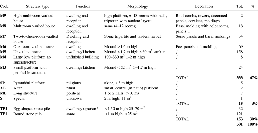
A great deal of morphological variability exists, but there is little functional diversity. While 67% of all surface remains can be firmly identified as ruined residences (M9–M3; n = 333), only 3% include small pyramidal foundations, small altars, and/or a few long structures (none excavated). No more than five mounds (coded SP) can be interpreted as domestic shrines of the type well known in eastern Peten and Belize patio groups (see Becker Reference Becker2004). Our complete exposure excavations in nine dwelling units tend to confirm this negative evidence, with the exception of the pyramid-temple abutting the southern façade of Building A (see Michelet et al. Reference Michelet, Nondédéo, Patrois, Gillot and González G2013). Stone piles represent 30% of all identified domestic remains, a proportion inferior to that noted by Thomas (Reference Thomas1981; see also Carrasco Vargas et al. Reference Carrasco Vargas, Boucher and Peña Castillo1986:23–24; Eaton Reference Eaton1975; Turner Reference Turner1983) around Becan (roughly 1,100 of 1,900 mounds;), likely due to poor survey visibility conditions in the Río Bec forest. The TP1 and TP2 types are probably underrepresented in the nuclear zone. A sample of six TP2 piles was tested, among which three were found to have covered stone wall remains, possibly from earlier dwellings built on a paleosol, or bedrock. In contrast, 10 TP1 piles tested did not cover any such vestige. Instead, they represent small, eroded platforms stripped out of much of their material by later constructional and agrarian activities (see Lemonnier and Vannière Reference Lemonnier and Vannière2013). Not taking into account late superficial stone covers (TP2 types), all the tested piles predate the Río Bec phenomenon with the three latest ones assigned to the Kanlol phase (a.d. 550–700). These two types of remains may then provide significant evidence for a dwelling system built with unworked stone and perishable materials, largely abandoned by the beginning of the Late Classic period (at the latest), and partially replaced by the Río Bec settlement system of M9–M6 masonry houses (see Taladoire et al. Reference Taladoire, Dzul, Nondédéo and Forné2013). In summary, the quantitative importance of this earlier system, itself disrupted by later agricultural modifications, is likely underestimated in the Río Bec systematic survey.
Elementary residential units were defined in a further analytical step through a systematic comparison of all surveyed structure clusters, based on relative distance to nearest neighbor, and the types of structures present within the clusters. While taking into account former classifications from other sites (Lemonnier Reference Lemonnier2009; Palka Reference Palka1997; Thomas Reference Thomas1981), the definition of units at Río Bec is adapted to local evidence, in particular to the data series obtained in the nine units that were entirely cleared. The discriminating distance between units is 25–30 m, so that structures or mounds less than 25 m apart pertain to the same unit. Two neighboring units more than 30 m distant each contain one structure of the M5 or M3 type that, in all likelihood, was used as a kitchen separate from adjacent dwellings. This is in agreement with the fact that in excavated household units, a separate kitchen is the type of discriminating structure (Déodat and Arnauld Reference Déodat, Arnauld, Nondédéo and Breton2012). Originally known only for its famous two-towered building (Structure 6N1), Group B is treated as a monumental group at the scale of the 100 km² micro-region but, when excavated, it was actually found to be made up of five units (see also Arnauld et al. 2013:Figure 5) (Figure 7), four of which include a separate kitchen (the fifth one being an isolated dwelling). The 6N1 towered structure is the main residence of the unit labeled B-6N1, with a second residence of the same exterior dimensions (Structure 6N2), two smaller houses (Structures 6N3N and 6N3S), and a kitchen (Structure 6N8). The four additional residential units in Group B (Units 6N4, 6N5, 6N6, and 6N9) are made up of only one to three structures each. These five units have differing construction sequences, but their vaulted structures (Units 6N1, 6N2, 6N3, 6N4, and 6N6) were occupied simultaneously throughout the Late and Terminal Classic period. Among other monumental groups in the 159 ha zone, only Groups G, P, and R also contain three to four distinct units (where the rare exceptions to the distance rule are found). In contrast, excavations of Groups A and D showed that each corresponds to a single unit: Unit A contains the large residential Structure 5N2, a kitchen and a small (unexcavated) mound, while the neighboring (excavated) Unit 5N4 is located 60 m away. As for Unit D-7N1, it contains four residences and one kitchen organized around a patio, with Unit 7N63 (also excavated) located 80 m away. Distance analysis and distribution of structure types both indicate that all remaining monumental groups form one single residential unit each, confirming the weak trend toward clustering, even though some of these units are unusually large and could lodge many nuclear families, in accordance with the Río Bec dwelling system.
Residential units identified in the central sector of the nuclear zone. Drawing by Philippe Nondédéo, Dominique Michelet, and Eva Lemonnier.
In the 159 ha zone, the 125 distinct residential units identified include 70% of the surveyed structures, along with some clusters of stone piles TP1-TP2 associated with mounds M6, M5, or M3 (isolated stone piles were not counted as units). The density of the settlement in the nuclear zone is .78 units/ha. The density is even lower (56 units/ha) if units occupied before and after the Late-Terminal Classic period Makan 2-Xpuhuk 1 sub-phases (a.d. 800–950) are excluded (including 37 earlier and later units; see below). On average, the land extent available to each unit would have been 1.8 ha around dwellings (including channels and bajos), which represents a significant area for an intensive infield agricultural system (Lemonnier and Vannière Reference Lemonnier and Vannière2013).
Characterizing the layout of all 125 units contributes to a reevaluation of the general category of “patio groups” or “courtyard groups” in the Maya lowlands (Adams Reference Adams and Ashmore1981; Lemonnier Reference Lemonnier2011; Rice Reference Rice, Wilk and Ashmore1988; Schwarz Reference Schwarz2009; Tourtellot Reference Tourtellot, Wilk and Ashmore1988b). Confirming similar observations made at the micro-regional scale, Table 7 shows that only 24.8% correspond to patio units, while 68% present an informal layout with no more than one or two structures each in most cases (23 and 43 units, respectively). The degree of clustering is weak, even if an unknown number of apparently isolated mounds may cover two or three structures (as demonstrated by excavation in several cases). Only four units contained a double patio. Limited clustering—probably even more so than in the micro-region—indicates that units did not grow because of the frequent splitting of households. There are few examples of neighboring units that would qualify as a “clustering of clusters” (Brown and Witschey Reference Brown and Witschey2003; Nondédéo and Michelet Reference Nondédéo, Michelet, Berger, Bertoncello, Braemer, Davtian and Gazenbeek2005; Peterson and Drennan Reference Peterson and Drennan2005). As will be discussed below, the clustering parameter has little pertinence in rank-ordering the dwelling units. The Río Bec architecture and dwelling system stimulated the formation of large, multi-family residences instead of many small houses grouped together.
Types of spatial layouts among dwelling units of the Río Bec nuclear zone (159 ha)
A SOCIETY OF RANKS: HIERARCHY OF RÍO BEC DWELLING UNITS AT THE NUCLEAR ZONE SCALE (159 ha)
Results of the complete-exposure excavations in Groups A, B, and D, as well as in a few neighboring units, largely guided the selection of criteria for the ranking analysis. Room count (see Table 6) provides a reasonably good and simple assessment for architectural geometric volumes and elaborateness (vault connections), as well as dwelling capacity and complexity (Blanton Reference Blanton1994). At the level of each dwelling unit, the total room counts for all houses, separate kitchens, and supposed storage rooms were selected as criterion for establishing economic and social relevancy. As for qualitative criteria (for example, façade and roof elaboration), they are more difficult to assess as the nuclear zone survey did not give priority to standing architecture, and another more inclusive proxy had to be devised.
Some clues from excavated structures suggest that Río Bec houses should not be seen through our etic archaeological and architectural categories reifying the preserved ruins, but should rather be considered as emic intentions, or “works in progress” that were interrupted by the Terminal Classic period abandonment. Decorated façades are not exclusive to large structures; some one-room (M6 type) structures show inset panels and even carved doorjambs (observed, for example, in Group D). Details excavated in a decorated two-room residence (Structure 7N1 in Group D) (Arnauld et al. Reference Arnauld, Michelet and Nondédéo2013) demonstrate that this M7 building was a project in progress, and even make clear what the intended concept was, although it was never completed. In the nuclear zone, the analysis of room counts and ground plans also reveals a few cases of structures lacking one wing in a tripartite layout, while several façades have parts left without veneer stone. The notion of projects in progress complicates matters as it results in an intricate distribution of decorative and elaborate features across most house ranks, partly determined by builders' intention through time.
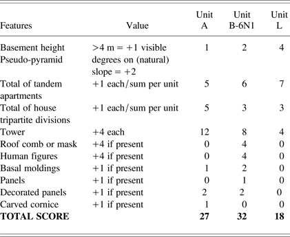
We also sought to devise a method to rank order Río Bec units reflecting the degree of completeness of a project at the level of the unit for a given time period (see below). Units with several “finished structures” showing completed ground plans with tripartite layout (core and two wings), several tandem rooms, as well as façade and roof decoration should reach higher scores. Furthermore, our premise is not only that these buildings displayed a prestigious appearance, but also smaller ones gave the outside visitor the impression of residences either achieved or in progress (what Blanton [Reference Blanton1994] calls “house canonical communication”), with their chief occupant seated in the central room framed by façades, each with a number of specific messages delivered by decorative details, or their absence (Blanton's [Reference Blanton1994] “indexical communication”). This “reception setting” (see Arnauld et al. Reference Arnauld, Michelet and Nondédéo2013), or “what the outsider can see on his path inward along the line of travel […] passing through the formal entrance” (Blanton Reference Blanton1994:11), had both a social and political value that must be taken into account as much as the volumetric and technical dimensions of each household unit. Thus, following Turner and colleagues (Reference Turner, Turner, Adams and Ashmore1981) and Blanton (Reference Blanton1994:115–148), we created a simple “index of reception settings” (RSI). At the unit scale, for all vaulted houses, the RSI sums the scores derived for foundation height, components of ground plan, and decorations, if present. As most of the structures coded for these variables were unexcavated, items located on parts generally hidden under rubble were assigned low values. Table 8 provides the total RSI value calculation for three of the most monumental units in the nuclear zone: Unit A (three structures), Unit B-6N1 (five), and Unit L (four). The RSI value is not redundant with the dwelling capacity value or total room count per unit, but it partly co-varies with the main house type. Finally, the last criterion scored independently was the number of long halls (>10 m) present within houses, as a measure of the unit capacity for meeting and, possibly, feasting.
Reception Setting Index (RSI) values calculated for three dwelling units with standing architecture in the Río Bec nuclear zone (159 ha)
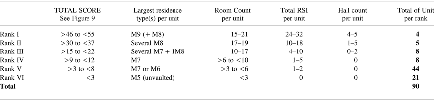
Only Late-to-Terminal Classic period units—those contemporaneous with the Río Bec apogee—were rank-ordered. Thirty-seven units were excluded, either dated to the pre-Makan 2 (17 units total based on test pit results) or post-Xpuhuk 1 (20 units total based on test pit results and morphology; for example, isolated small mounds). This left 88 units, to which were added two large units, Structures O and E, located close to the nuclear zone boundary that must have had some impact on settlement patterns within the zone. These 90 units were rank-ordered according to their individual score summing three variables: total RSI per unit, total number of rooms per unit (including kitchen and storage rooms), and total number of long halls. The type of the main residence (M9–M5) also provided a rank ordering roughly consistent with the above hierarchy.
As shown in Figure 8, this method distinguishes among five ranks, with the lowest two being poorly defined. Splitting Rank V, according to the presence/absence of vaulted structures, can create an additional Rank VI category. The adopted criteria are not adapted to simple domestic architecture. The quantitative hierarchy of criteria and subsequent distribution of all 90 units among ranks are summarized in Table 9. As expected, considering the broad spatial distribution of vaulted structures, the lowest rank is not disproportionately abundant (23.3%), yet the proportion is high (72.2%) for units totaling less than six rooms each. The Rank I category includes Units B-6N1, O, C, and A (respectively, as they appear in the hierarchy established for the micro-region) (see Table 5, where they appear clustered in Ranks II and III), while Unit C has likely been underestimated (see below). Rank II contains Groups L, J, E, H, and K. Minor discrepancies are due to some errors in room count assessment during surface survey, and to some components underscored in the RSI count for unexcavated units. It is important to recall that towers are present on large residences in Units A, B-6N1, and L only. Several high-ranked units include large houses probably in progress that were left unfinished in their early stages of construction (Units 7M45, L and H) (Arnauld and Gillot Reference Arnauld and Gillot2009). Along with the fact that Ranks II, III, and IV include almost equivalent numbers of units (5, 8, and 8), these findings suggest that most households were engaged in a strong competition and that advances in some architectural projects could have shifted positions in a few years.
Rank-order of 90 dwelling units dated to the Late-Terminal Classic period (a.d. 800–850) in the nuclear zone. Twenty five units are represented individually, while the remaining units are clustered according to their scores. Chart by M. Charlotte Arnauld.

Quantitative hierarchy of criteria for 90 Late-Terminal Classic dwelling units (Río Bec nuclear zone)
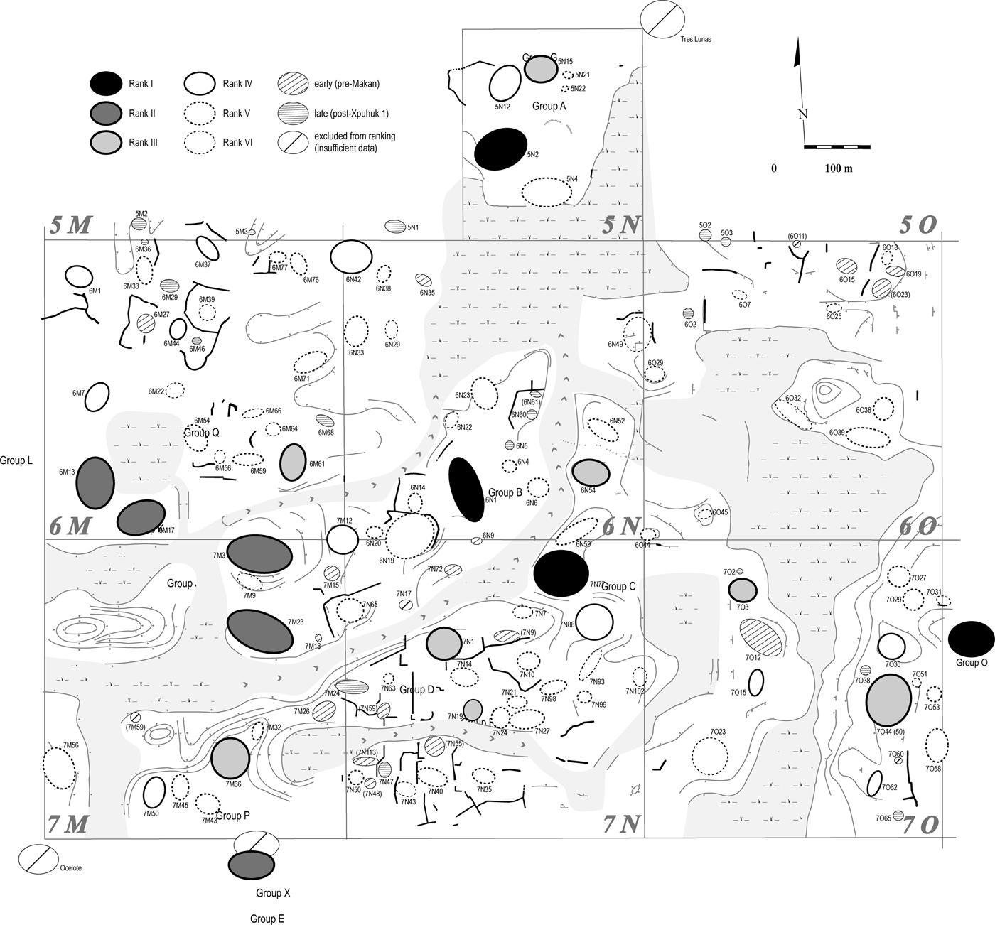
The spatial distribution of rank-ordered residential units is given in Figure 9. The distance among the units in Rank I varies from 600–800 m, except in the case of Units B-6N1 and C that are only 125 m apart, and separated by a natural, relatively shallow drainage channel. Settled almost side by side, these two powerful units are located roughly at the core of the central concentration on the Río Bec plateau. Paradoxically, while the micro-regional (100 km2) spatial distribution of ranked groups shows the highest-ranking ones located on the margins of the micro-region (Omelita, El Porvenir, Group I) (see Figure 6), at the scale of the 159 ha zone, the two most powerful units, Structures B-6N1 and C, are found at the very geometric center. This calls for several comments. First, and undeniably, the perception of Río Bec settlement as being centered around the famous “Structure B” (6N1) since its initial discovery was not entirely mistaken. In the second residence of the same unit (Structure 6N2), our first excavations in 2003 uncovered, rather than a stela, three painted polychrome benches with glyphic inscriptions (Arnauld and Lacadena Reference Arnauld and Lacadena2004; Arnauld et al. Reference Arnauld, Michelet and Nondédéo2013).
Spatial distribution of 90 ranked residential units in the 159 ha nuclear zone. The oval symbols delineate the spatial extent of each residential unit. Note the tendancy of Rank I–III units (those with the most elaborate residences) to cluster in pairs. Map by M. Charlotte Arnauld.
Second, the apparent centripetal character of organization in the 159 ha zone, when compared with the clearly centrifugal trends in the 100 km2 micro-region, is in good part an effect of scale, as we initially delimitated our small-scale study zone within the central concentration of the settlement core where the monumental groups' density is highest. Groups of lower rank (Ranks III and IV) do cluster around Units B-6N1 and C suggesting that the presence of these two units affected their growth, whereas Rank II groups that tended to reach the top are located at a good distance from Structures B-6N1 and C. Not surprisingly, the highest-ranking units (A and O) are found farther away on the 159 ha north and east margins, indicating that centrifugal trends can be discerned also at this scale.
Third, the two units (B-6N1 and C) could have formed a pair and thus be tentatively compared with the top-ranked groups of the micro-region (Groups I, Omelita, El Porvenir) defined as clusters of contemporaneous residential units in which several allied, large noble houses coexisted (see above). The latter, however, are not divided by any natural boundary as Units B-6N1 and C are, and those two groups do not show the same sequence of occupation. Almost certainly founded earlier, Unit C was never surpassed by Unit B-6N1, having reached a total of 10 structures bordering a “plazuela” (approximately 1,200 m2). It shows a late evolution over a short period (a.d. 800–950), with the construction of a decorated building (Structure 7N75), and two large structures with long halls on high platforms also morphologically late in time. This development is contemporaneous with the apogee of Unit B-6N1, when both units together concentrated almost a dozen lesser units within a radius of 130 m (Figure 7). Of all units supposedly involved in this entity, Group C is, unfortunately, the least documented (five test pits). Although extremely demanding in excavation, its detailed sequence of construction-occupation compared to that of Structure B-6N1 would certainly reveal an interesting succession of competitive and cooperative phases. Regardless, the late coexistence of those two powerful groups over 150 years indicates a (final) period of stable alliance, probably through marriages that repeated generation after generation (Arnauld et al. Reference Arnauld, Michelet and Nondédéo2013).
Long-term continuity and stability, likely through alliance, is confirmed by further evidence in the distribution of ranked groups. Like the pairing of Units B-6N1 and C, some Rank I units have Rank II units among their nearest neighbors, and similarly Units L and K form a Rank II pair (60 m apart), as do Units J and H. These pairings among relative “equals” contrast with more “unequal” pairings reflected by the proximity of Rank III units to high-ranking units occupied during the same time span (for example, Groups A and G that are separated by only 120 m). Nevertheless, cases of high-ranked units absorbing neighboring lesser units are also known (Taladoire et al. Reference Taladoire, Dzul, Nondédéo and Forné2013; see also Michelet et al. Reference Michelet, Nondédéo, Patrois, Gillot and González G2013). These dynamics may have determined the emergence of neighborhoods on peninsulas circumscribed by drainage channels (Arnauld et al. Reference Arnauld, Michelet, Vannière, Nondédéo, Lemonnier, Arnauld, Manzanilla and Smith2012). Agrarian factors had a strong impact as those distinct processes of neighborhood formation and lesser units absorption led to the emergence of a few landed estates larger than the average land extent available elevated to each dwelling unit (see Lemonnier and Vannière Reference Lemonnier and Vannière2013).
CONCLUSION
What the study of Río Bec settlement patterns at two distinct scales (100 km² and 159 ha) reveals is a complex combination of political and social dynamics throughout the Classic period and into the Late-to-Terminal Classic apogee. In a settlement fragmented by a multitude of small-sized monumental groups composed of a few residential units, no true center, epicenter, or central place ever emerged to which these many groups could have been politically subordinated. Even Group V, which appears to have proclaimed royal status for a period of time, well defined by its stelae inscriptions and dates, does not qualify archaeologically as a center attracting large social groups and stimulating nucleation. In any case, resettlement and nucleation trends remained weak everywhere. On the plateau, however, a relative spatial concentration of groups can be shown to have existed from Kanlol 2 to Makan 1 sub-phases (a.d. 620–800), along an arc joining Groups B and O to the Thompson Group, and this is properly “the Río Bec settlement core.” But a short time later, the powerful Group I, followed by the equally powerful Group V, emerged to the west, as did El Porvenir and Omelita to the east, on the margins of this original core. These late-founded groups were settled in vacant areas allowing them to enjoy social and demographic growth without suffering from rivalries among powerful neighboring houses and land availability constraints. To the north of the plateau, low-ranking groups in high densities define a kind of core periphery. In other words, the very presence of a central concentration during Late Classic phases would have generated centrifugal trends, as emerging social groupings preferred to risk resettlement on margins (colonization) rather than seeing their growth thwarted within the core. Considering the number of people concentrated in the newly founded groups and contemporaneous dynamism of the core zone, one wonders whether, during Terminal Classic period, if the micro-region had not received external populations bringing additional labor, probably from the south, as an early effect of the collapse of the southern lowlands (see Demarest et al. [Reference Demarest, Rice and Rice2004] for a discussion of Terminal Classic period migration). This would have been of great benefit to the Río Bec noble houses, allowing them to prolong their apogee.
Higher-resolution analyses of spatio-temporal dynamics at the 159 ha scale confirm, and to some extent explain, the weakness of nucleation trends by simultaneous processes: frequent splitting in lesser households, and house growth (socially and architecturally) in more powerful groups, the latter seeking to lodge as many nuclear families as possible under the vaulted roof of one large multiroom residence, a specificity of the Río Bec architecture. Those who succeeded in mobilizing several neighboring households were able to invest resources to launch relatively long-term architectural projects (over one to three or more generations). During their formation as both social houses and landed estates, the monumental groups played a structuring role in the Río Bec settlement core. A local process of long-term stable alliances linking pairs of neighboring groups is evidenced through our analyses of the dispersion, hierarchy, and spatial distribution of rank-ordered groups dated to the Late-to-Terminal Classic period. Yet, while long-term proximity suggests regular cooperation, episodes of emulation and strong competition must have obligated more than one household to try its luck farther away, provoking a centrifugal resettlement that distanced the latest groups toward the periphery—a trend visible at both the 100 km2 and 159 ha scales. Incipient collective action, apparently often restricted to two allied groups, alternated between rivalry and exclusion (Blanton et al. Reference Blanton, Feinman, Kowalewski and Peregrine1996; see also Bazy et al. Reference Bazy, Valdés, Arnauld, Ruiz, de León and Cuerva2010).
As thoroughly discussed by Arnauld and colleagues (Reference Arnauld, Michelet and Nondédéo2013), the model of house societies defined by Lévi-Strauss (Reference Lévi-Strauss and Modelski1982) best elucidates the complex dynamics of ancient Río Bec society. Locally dominant houses possessed their own system of representation in which writing (embedded in domestic architecture) was anecdotal, and where the springs and spirits of divine kingship had ceased to structure all social relations. Their hierarchy was relatively unstable, as ranks changed through the development of many architectural projects, the absorption of neighboring households and the expulsion of stem groups, probably reflecting complex growth and alliance strategies. All this confirms how much the Río Bec phenomenon differed from other Late Classic central lowland societies defined by divine kingship. But the measure of this dissimilarity is a question of scale across time and space.
Limited to a relatively small territory, the short-lived Río Bec apogee, and its translation into an architectural horizon that spread far beyond its original area (Arnauld and Nondédéo Reference Arnauld, Nondédéo, Van Broekhoven, Valencia, Vis and Sachse2010; Nondédéo Reference Nondédéo2003; Nondédéo et al. Reference Nondédéo, Patrois, Lacadena, Arnauld, Taladoire and Michelet2011), might be paradigmatic of only one specific moment in the sequences of many lowland cities. Generally, in the latter, the trend toward settlement nucleation and formation of “royal cities” operated among a limited number of noble houses emerging early from local peasant societies, and the process accelerated through the impact of the emerging royal dynasty upon the clustered houses. When and where the latter did not occur or was temporarily weak, part of the nucleating force was lost, especially where some demographic pressure on land availability made resettlement on vacant sectors a necessary enterprise, even if it was a risky one. Furthermore, the Río Bec evolutionary pattern suggests that local Early-to-Late Classic economic prosperity was totally invested in agricultural intensification along with residential architecture, without much input from either interregional trade or local craft production (Andrieu Reference Andrieu2013; Nondédéo et al. Reference Nondédéo, Patrois, Lacadena, Arnauld, Taladoire and Michelet2011). Added to the weakness of local rulers, the lack of trade and craft prosperity would have, in turn, debilitated the attraction capacity of local houses. We surmise that, when agrarian factors weighed more heavily than trade and craft factors in the Classic period prosperity of lowland Maya societies, dispersal trends are more efficient than nucleating forces, with the former being reinforced by noble houses seeking external alliances with groups located far away from their ancestral base. Río Bec centrifugal forces may well be the paradigm of the Terminal Classic period Maya lowlands.
RESUMEN
Desde los trabajos pioneros de Merwin, Ruppert y Denison y, más recientemente de Adams, los grupos monumentales de Río Bec llamaron la atención al ser diferentes de los modelos de organización espacial y social, y de urbanismo de las ciudades mayas en las tierras bajas centrales. Para estudiar el patrón de asentamiento local, se requirió un análisis a doble escala: se delimitó primero “la micro-región” de Río Bec, un cuadro de 10 × 10 km, para contextualizar lo que, en 2002, hemos definido como la “zona nuclear” de Río Bec, una ventana de estudio de 159 ha centrada en los Grupos A y B, la cual corresponde al sector con la densidad más elevada de grupos monumentales presentando la típica arquitectura Río Bec. A ambas escalas, el objetivo del presente estudio es analizar el patrón de asentamiento para esclarecer las razones por las que los procesos de nucleación no se llevaron a cabo localmente a diferencia de lo ocurrido en los demás centros mayas. Ya que los datos acumulados permiten descartar una respuesta estrictamente cronológica, la pregunta tiene una dimensión social a escala de la zona nuclear, y otra, más bien, política a escala de la micro-región. Nuestro enfoque consiste en analizar la dispersión espacial del asentamiento relacionándola con su jerarquía interna y tomando en cuenta su evolución temporal.
Desde su descubrimiento el “sitio” de Río Bec ha sido difícil de reconocer e interpretar, y se creía que los pocos grupos monumentales entonces conocidos formaban parte de un amplio sitio cuyo epicentro quedaba por descubrir. Aún así, Adams entendió que cada grupo monumental correspondía a una unidad social similar a las unidades pequeñas de montículos con funciones privadas. Pero su tamaño y su arquitectura le conferían una función pública al suponer que su construcción se asociaba a alguna comunidad. Las investigaciones realizadas por el Proyecto Río Bec (2002–2010) llegaron a una conclusión bastante distinta.
En la zona nuclear, una prospección sistemática e integral registró un total de 501 montículos, incluyendo 333 estructuras residenciales además de vestigios mixtos (domésticos, agrarios y restos de construcción). Los sistemas de drenaje natural de las aguas en dirección de los bajos definen unidades de paisaje cuyas partes elevadas contienen la mayoría de los vestigios antrópicos. La densidad de estructuras es de 317 por km2 (deduciendo pantanos y drenaje), superior a la de zonas residenciales de otros sitios, pero inferior a la de sus epicentros. En la micro-región, la prospección fue semi-sistemática con informantes y brechas de exploración, registrando un total de 73 grupos, de los cuales 25 se conocían desde antes del proyecto. Se hicieron sondeos en 35 grupos y se mapearon 38 de ellos.
En la micro-región, después del preclásico-clásico temprano en que dominaba la tradición petenera de las tierras bajas centrales perceptible a través, entre otros, de la organización en plazas públicas como en Kajtun o en el Grupo II, se desarrolló, a partir de 550 d.C., un patrón de asentamiento distinto, organizado en pequeño grupos monumentales muy dispersos sobre vastas áreas que muestran los rasgos arquitectónicos Río Bec. Cada grupo contiene pocas estructuras (73% con menos de 10) dispuestas a menudo de modo informal (sólo 35% con patio), en grupos tanto monumentales como modestos. Los análisis sugieren marcadas tendencias a la división a través del tiempo y a la dispersión centrífuga a varias escalas. Con el desarrollo del estilo Río Bec las residencias principales adquieren más capacidad de alojamiento en cuartos. Sin embargo, ninguno de estos grupos alcanzó a ser un centro nucleado y acaparar el poder a nivel local, ni siquiera el Grupo V a pesar de su plaza central con estelas fechadas del clásico tardío-terminal. El análisis de distancia entre vecinos (350 m en promedio, hasta 1,000 m) determina una concentración central de grupos, otra oriental, ambas separadas por 1,000 m. La jerarquía interna, de cinco rangos, establecida sobre una muestra de 62 grupos con base en 12 criterios reflejando su relativa importancia sociopolítica es válida para el momento de apogeo de la micro-región (hacia 850 d.C.). Los tres grupos que ocupan la cúspide de la jerarquía conocieron un desarrollo bastante tardío (hacia el final del clásico tardío) y se localizan en los márgenes oeste y este de la micro-región, confirmando una tendencia centrífuga. La interpretación política del patrón espacio-temporal reconstruido indica que dicha micro-región fue fragmentada en una serie de casas nobles que formaron pequeños dominios y no lograron concentrar la población ni centralizar el poder.
Situada en la concentración central, la zona nuclear ofrece datos adecuados para el análisis de las dinámicas sociales. Se definió una tipología de viviendas (nueve tipos), que llevó a delimitar 125 unidades habitacionales con base a asociaciones de tipos y análisis de distancias. Su configuración (escasos patios, bajo grado de nucleación) confirma las tendencias a la división. La jerarquía (establecida para 800–850 d.C.) de dichas unidades definió seis rangos a partir de tres criterios compuestos que reflejan el grado de elaboración de los proyectos arquitectónicos en cada unidad. En la distribución espacial en el área de 159 ha destaca cuatro unidades de mayor rango, de las cuales dos (Grupos B y C), localizadas en el centro de la zona, podrían haber formado en momentos de su historia una alianza estable. Enfatizando este proceso de alianzas, también en la zona se observan otros pares de unidades de alto rango o de diferentes rangos. La distancia observada en los demás grupos de rango I (Grupos A y O) confirma la tendencia centrífuga detectada a escala micro-regional, generada por la relativa densidad de casas poderosas en la zona nuclear y la estabilidad de sus alianzas.
Acknowledgments
We thank all the project members, whose work, data, and interaction have greatly contributed to our understanding of the residential system at Río Bec. We also thank the Peabody Museum of Harvard University for allowing us to study materials from the Carnegie Institution Archives. Our gratitude also goes to the three anonymous reviewers for their helpful comments and suggestions, all of which enriched the paper. Finally, we gratefully acknowledge the essential support of local authorities and ejidatarios of Veinte de Noviembre without whom this project could not have been possible.