
Introduction
This article examines archaeological evidence to argue that Christian sacred spaces built along the Roman frontiers during the fourth and fifth centuries offered worshippers spatial experiences of worship, ritual and commemoration similar to those afforded by the Constantinian monumental churches of Rome and the Holy Land.Footnote 1 Previous research has focused on individual frontier sacred spaces from this period. A study of how their architecture influenced worshippers’ spatial experiences and the extent to which these were shaped by metropolitan ecclesiastical centres remains a potentially impactful and largely unexplored area.
For this article, ‘spatial experience’ is defined as the way in which the architectural elements of churches – such as entrances, exits, processional routeways and screening – together with the creation of funerary or cemeterial churches and external baptisteries, were perceived and engaged with by those gathered for worship, ritual or commemoration. It argues that these architectural features were important factors in how these sacred spaces were experienced, and that these elements of the Constantinian church-building programme influenced Christian worship practices across the Roman empire, including its frontiers. Furthermore, it will show that while Christian sacred spaces in frontier regions generally conformed to Constantinian architectural trends, they were also subject to local adaptations, demonstrating an interplay between sacred architecture, worship practices and cultural contexts.
Christian Sacred Space prior to Constantine
As the church detached itself from temple and synagogue worship, early Christian communities gathered for worship in domestic settings, most probably in the triniculum (dining room).Footnote 2 They also met in rooms above shops, in tenements, apartments above baths, or other commercial spaces, with no particular setting being dominant.Footnote 3 Although these house churches were unrenovated rooms, much as they would have been in any private house, this did not negate a sacred connotation, and even though Christian worship spaces were materially unaltered from their day-to-day uses, they acquired temporary sacrality through ritual performance.Footnote 4
Since the 1960s, the significance of a perceived intermediate architectural stage in the development of early Christian sacred space, believed to have emerged in the mid-third century, has been debated. This development, known as domus ecclesiae (‘house of the church’), involved modifying domestic houses to accommodate evolving ritual practices.Footnote 5 The earliest known example was excavated in the 1930s at Dura-Europos (near modern-day Dayr al-Zawr in eastern Syria), a much-contested city in the border region between the Roman and Persian (Sassanian) empires, and dates to c.240, when a private residence was converted into a Christian assembly space, with a large meeting hall and a baptistery decorated with Christian murals.Footnote 6 However, the broader existence of the domus ecclesiae as a pre-Constantinian phenomenon is increasingly challenged. Critics argue that Dura-Europos was probably a unique local adaptation rather than a widespread trend.Footnote 7 Similarly, the tituli,Footnote 8 the local variation of the domus ecclesiae in Rome, purportedly renovated from private residences, lack solid literary or archaeological evidence from before the fourth century.Footnote 9 However, while debates continue around the evolution of Christian sacred spaces before Constantine (r. 306–37), this article focuses on the development of purpose-built Christian sacred spaces in the fourth and fifth centuries.
The Constantinian Church-Building Programme
In 313, the co-emperors Constantine and Licinius issued the Edict of Milan, legalizing Christianity. Christians were given the freedom to practise their faith openly without the threat of persecution, and Christianity was afforded the same legal status as other religions throughout the empire. This edict signalled the beginning of the so-called ‘peace of the Church’, a new era of church polity.Footnote 10 Under Constantine’s reign, the church’s position and organization became closely associated with the emperor’s authority.Footnote 11 Constantine encouraged bishops to restore older churches and construct new ones; at the same time, he initiated a church-building programme. Although Constantine initially ruled only the West, upon gaining control of the East in 323, he urged Eastern bishops to undertake similar efforts, with materials to be supplied through the provincial governments.Footnote 12
Constantine chose the basilica as the primary architectural form for his new churches, repurposing a structure rooted in secular Roman architecture to suit legalized Christianity. The basilica had undergone centuries of secular development, adopting various functions and architectural types, including as extensions to Roman fora and other public buildings, as places for commerce and the administration of justice, and as audience halls in imperial palace complexes.Footnote 13 The reasons for its selection are widely debated, but key theories include: the need for an architectural form untainted by the traditional temple architecture of the Greco-Roman world and Constantine’s desire to draw upon the architecture of the imperial court (Ward Perkins); the basilicas’ suitability to serve as ‘meeting halls for congregations … or meeting halls for burial and funeral rites’ and as ‘audience halls of the Lord’ (Krautheimer); their large, well-lit spaces, capable of extension and with a sense of movement along the longitudinal axis toward the apse, were well-suited for processions (Armstrong); the way in which basilicas (specifically the Lateran) ‘thematized vision and (in)visibility’ and highlighted such themes as magnificence, exclusiveness and power, highlighting the lordship of Christ (Dale); and that basilicas conveyed ‘royal splendor rather than imperial ideology’ (Stewart).Footnote 14
Constantinian church ritual required significant ‘concerted movement’ by its participants.Footnote 15 The multi-aisled basilica was well-suited for processions within the eucharistic liturgy. Even in frontier areas with smaller Christian communities, such processions were probably an important ritual experience. Processions were more than a practical means of movement from one place to another. They also created an atmosphere of celebration and solemnity for both participants and observers.Footnote 16 Literary evidence of processions within the liturgy is found in the writings of the late-fourth-century pilgrim Egeria, who described the liturgies she witnessed in the Holy Sepulchre and elsewhere in Jerusalem, in which worshippers moved in procession while singing psalms and hymns.Footnote 17 Egeria’s account offers insights into how Christian sacred space was experienced ritually.
Archaeological evidence from the Lateran Basilica in Rome (often referred to in the scholarship as the Constantinian Basilica), probably the first built under Constantine’s patronage, reveals how architectural elements were utilized to enhance spatial and ritual experience.Footnote 18 The fastigium, an ornate pediment adorned with silver statues of Christ and the apostles and supported by four bronze columns, separated the nave from the presbyterium (sanctuary).Footnote 19 The solea, a corridor-like fence, extended down the central aisle of the nave, forming a processional corridor for the entrance of the clergy.Footnote 20 Together, these elements influenced the spatial dynamics of experience within the basilica. The fastigium partially obscured the view of the apsidal presbyterium from the nave, drawing the laity’s attention towards the solea. However, only those in the front rows, on either side of the solea, would have had a clear view of the procession, suggesting that those who secured a vantage point near it would have enjoyed a more participative experience in the liturgy, including a full view of the liturgical procession of the clergy, and a partial view of the altar and the ceremonies occurring beyond the fastigium. Footnote 21
The basilica was to become the dominant form of church architecture across the empire, although Constantine’s churches varied in style. Notable examples include old St Peter’s in Rome, the Holy Sepulchre in Jerusalem and the Church of the Nativity in Bethlehem. These churches marked the emergence of architectural structures known as martyria, designed to commemorate significant biblical events and the veneration of the relics of the saints.Footnote 22 Innovations at St Peter’s were the incorporation of an atrium and a transverse hall (transept) separating the nave and the apse, immediately in front of which was a baldachino (a free-standing canopy) over the altar, above the shrine believed to mark St Peter’s grave.Footnote 23 St Peter’s was laid out on a grander scale than the Lateran Basilica and was richly embellished.Footnote 24 Understanding the archaeology of Constantine’s original Holy Sepulchre complex in Jerusalem is challenging, as much of it lies beneath or is incorporated into the present building. Constantine built a five-aisled basilica, the Martyrion, accessed via a triple-entranced atrium with a colonnaded courtyard to the east of the Aedicule (an ornate structure covering the tomb of Christ) and possibly a baptistery south of the church.Footnote 25 The Church of the Nativity in Bethlehem, like the Holy Sepulchre, drew upon St Peter’s basilical architecture, featuring five aisles and an atrium, but focused on an octagonal chamber memorializing Christ’s birthplace, instead of an apse.Footnote 26
Between the fourth and the sixth centuries, octagonal churches became popular for martyria, often incorporating the basilica’s rectangular shape to create grand, domed churches.Footnote 27 This innovation distinguished the martyria from rectangular basilicas, such as the Lateran Basilica, which were associated with regular worship and assembly.Footnote 28 Another development was the construction of cemeterial basilicas outside the walls of Rome, including the Basilica Apostolorum (San Sebastiano) on the Via Appia, and the Basilica Sant’Agnese on the Via Nomentana.Footnote 29 These were associated with the Christian catacombs, whose origins can be traced to the early third century.Footnote 30 By the late fourth century, the catacombs were increasingly linked to the cult of martyrs, leading to a growing desire for burials ad sanctos (‘near the saints’).Footnote 31
Monumental baptisteries also emerged in the fourth century, some as freestanding structures, and others as an intrinsic but distinct part of a church building. This separation emphasized the foundational nature of baptism as the entry point into the Church, and maintained the distinction between the baptized and those preparing for baptism (catechumens).Footnote 32 Typically, the baptismal font was placed at the centre of the baptistery, which could take a square, circular or polygonal shape, with a central, often octagonal, plan being common in many baptisteries in Italy and the East. The earliest documented central plan baptistery is the octagonal Lateran baptistery built next to the Lateran Basilica late in Constantine’s reign.Footnote 33 Its octagonal design probably influenced that of the baptistery of St Giovanni alle fonti at St Thecla’s Church, Milan, built c.350 by St Ambrose (c.339–97) and other baptisteries constructed in northern Italy in the fourth and fifth centuries.Footnote 34 The significance of the octagonal design is debated: traditionally, the number eight symbolized the renewal and resurrection, new beginnings and rebirth associated with baptism, but the popularity of octagonal halls in the fourth century suggests that caution is necessary in assuming a purely theological motivation.Footnote 35
Constantine’s church-building programme was marked by experimentation and creativity, producing diverse architectural forms, including multi-aisled basilicas, with or without apses, ambulatories and atria; centrally planned churches; and polygonal structures like martyria and baptisteries. Constantinian church architecture established a wide variety of church designs, and it was only in the fifth century that more stable regional norms and distinct building types began to emerge. Consequently, it is unsurprising that a significant degree of diversity and innovation can be also observed in the Christian sacred spaces of the frontier regions alongside continuity with and reinterpretation of those of Rome and the Holy Land. The case studies that follow will examine the implications of how these trends influenced the spatial experiences of sacred spaces on the Roman frontiers.
Case Studies
Methodology
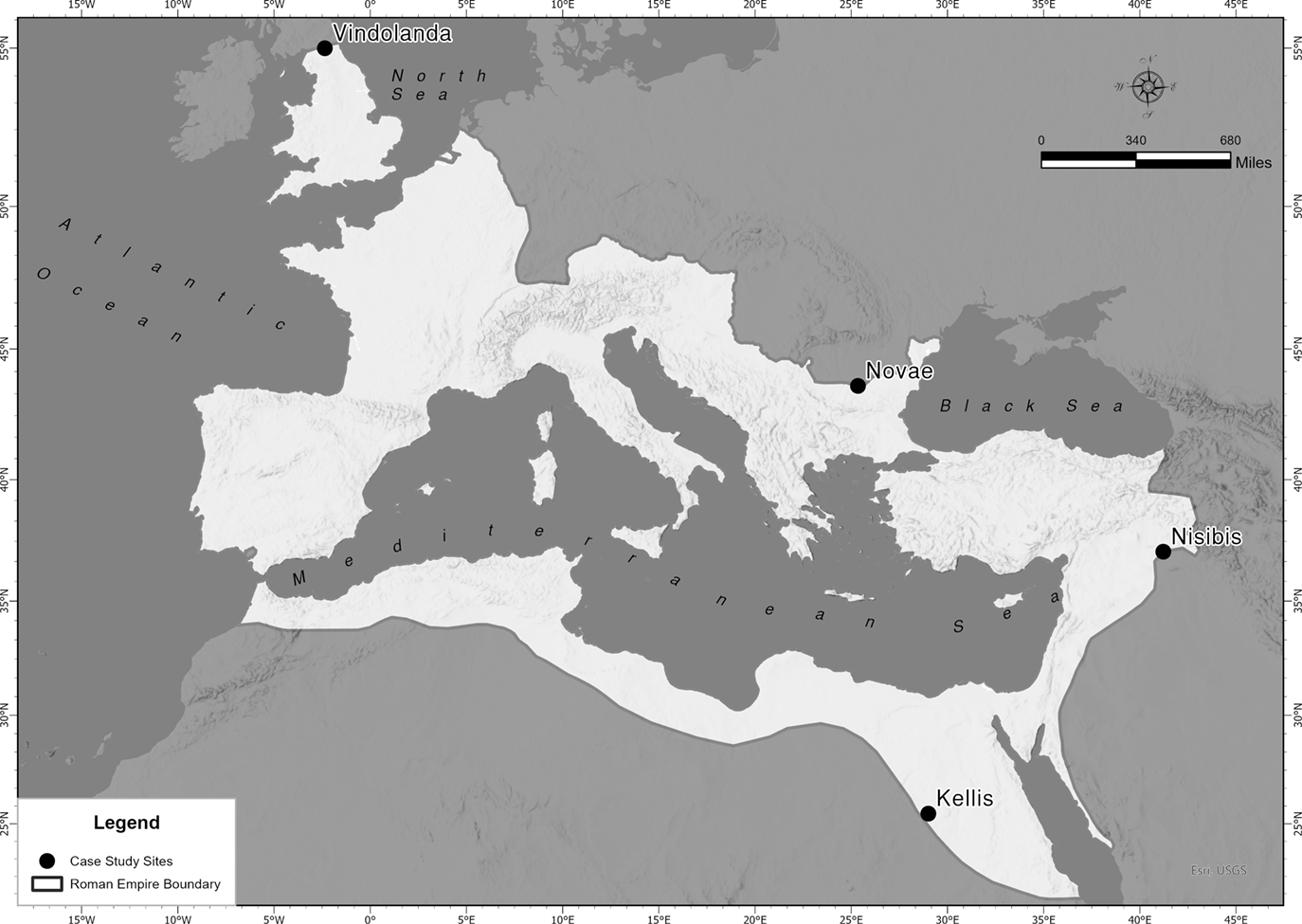
Four case studies have been selected from frontier sites: Kellis, in Egypt’s Dakhleh Oasis; Nisibis, near the border with the Persian empire; Novae, on the Danube frontier; and Vindolanda, on the northern frontier of Britain (Figure 1). These sites were chosen due to the presence of archaeological evidence of two or more Christian sacred spaces from the fourth or fifth centuries, and the availability of modern archaeological research associated with recent excavation of the sites. An additional incentive for selecting these sites is their archaeological complexity, which makes them fascinating and compelling research material. The lack of comprehensive modern archaeological research on Christian sacred spaces on other frontiers, such as the Rhine and Roman North Africa, limited the range and number of suitable case studies. However, the selected sites offer a robust dataset for investigating the spatial experience of Christian practice and worship on the Roman frontiers during this period.
Map of Roman Empire in the Fourth Century CE, showing the proximate locations of the four case study sites. Figure design: Dr. Ayoub Lahlouh, Abdelmalek Essaâdi University, Tetouan, Morocco.

Case Study 1: Kellis, The Dakhleh Oasis, Egypt
The Dakhleh Oasis, one of seven in Egypt’s Western Desert, was perceived as a ‘border-like’ environment in the fourth century despite not being a formal Roman frontier.Footnote 36 Seven churches in the Dakhleh Oasis are securely dated to the fourth century, with two more tentatively so.Footnote 37 Kellis (modern-day Ismant el-Kharab) was chosen as a case study due to the early date of its churches and the proximity and interrelationship between its small and large east churches.Footnote 38 Furthermore, the West Church Complex, a funerary church, offers a fascinating insight into how Christian sacred space was possibly used for the commemoration of the dead. There is no known literary or archaeological evidence for Christianity in the oasis much before the fourth century, when a robust Christian community is attested at Kellis. In addition to the surviving archaeology, textual sources, including fragments of a liturgical codex, papyrus and wooden boards bearing Christian prayers, epistles, personal letters and references to various bishops and priests, confirm the presence of a Christian community at Kellis by the early fourth century.Footnote 39
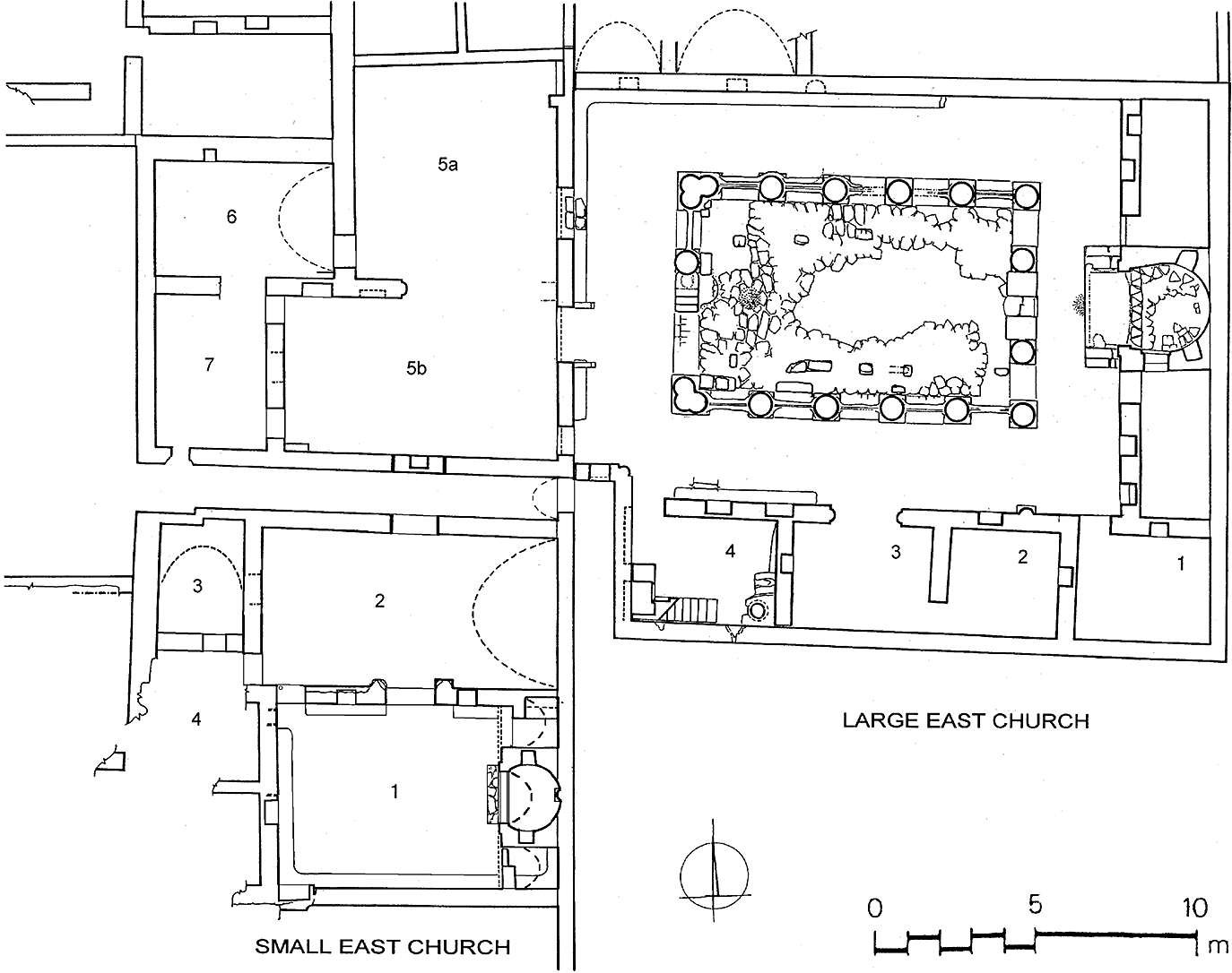
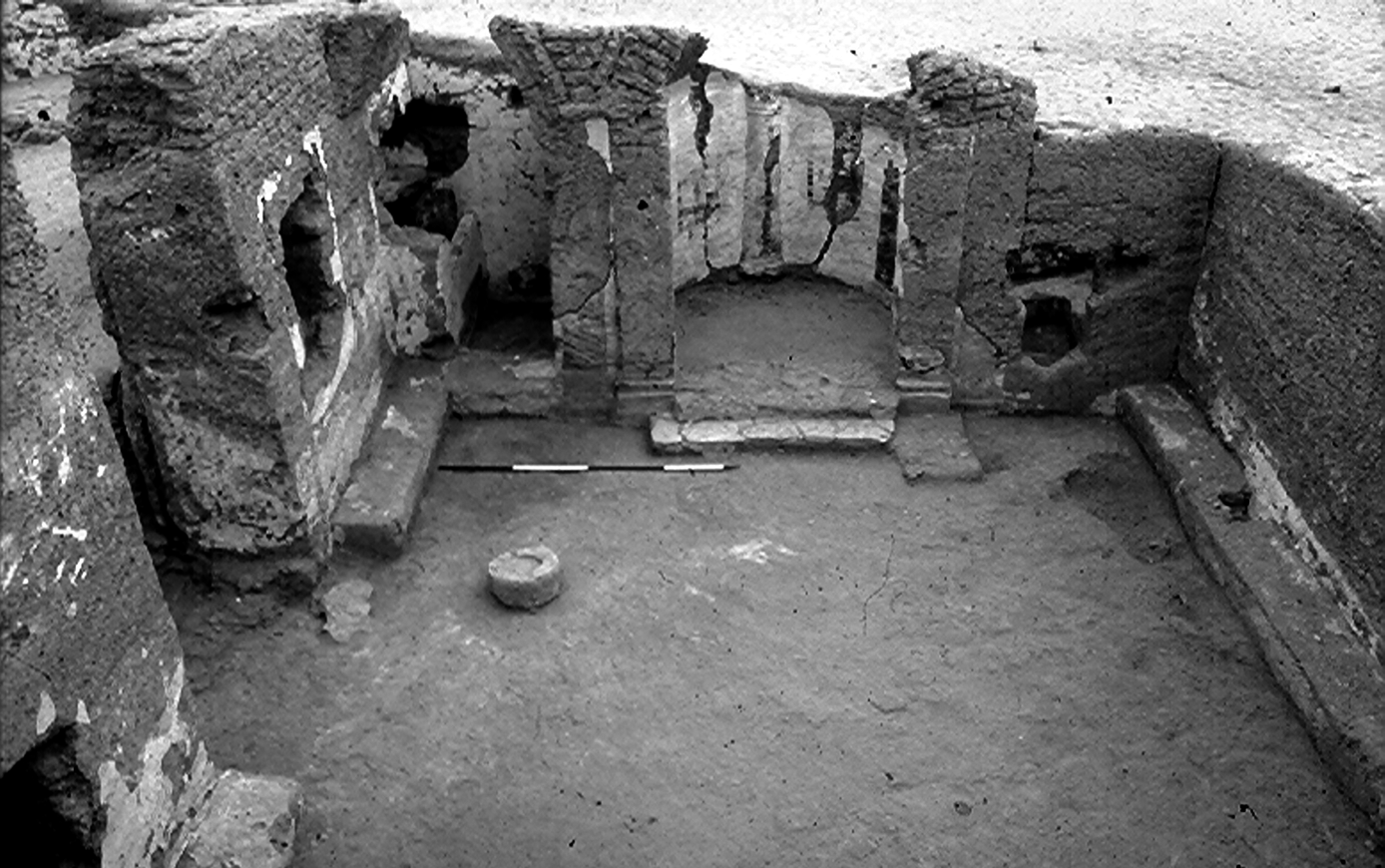
The Small East Church (20 m x 5.5 m) (Figures 2 and 3) consists of two rooms, with the church to the south (Room 1) and an adjoining room (Room 2) to the north.Footnote 40 Ceramic and numismatic evidence suggests a terminus post quem of 306–12 for the building’s modification.Footnote 41 Room 1 was transformed from a simple room lined with brick benches into a church, probably serving a public function before its adaptation. The excavators conclude that it may have initially been a domus ecclesiae that evolved over time to meet the community’s needs.Footnote 42
Kellis, Plan showing the relation of the Large East Church to the Small East Church; from Gillian Bowen, ‘The Christian Monuments of Kellis’, 66 (figure II.1). Copyright: Colin A. Hope and Dakhleh Oasis Project. Drawings: J. Knudstead, J. Dobrowolski and B. Rowney, modified by B. Parr.

Kellis, Room 1 of the Small East Church: the nave, following its conversion for Christian worship, looking east; in Gillian Bowen, ‘The Christian Monuments of Kellis’, 17 (plate I.2). Copyright: Colin A. Hope and Dakhleh Oasis Project. Photo: Colin A. Hope.

The main alteration involved the construction of a raised sanctuary with an apse and vaulted side chambers (pastophoria) for storage.Footnote 43 Access to the church was through Room 2, with a double door probably serving as the clergy’s processional route, while the congregation probably used the western door.Footnote 44 The rapid conversion of the building, including the creation of a nave and distinct sanctuary within an apsidal area, probably indicates a deliberate effort to create a more distinctive space for the celebration of the eucharistic liturgy. Such enhancements would have allowed for a visually richer spatial experience of worship beyond what the simpler space of a domus ecclesiae could offer. The transition of the Small East Church from a domus ecclesiae to a more formal ecclesiastical structure illustrates an early intentional enhancement of worship space. This transition, marked by the introduction of a raised sanctuary and defined processional routes, reflects a sophisticated approach to spatial organization designed to create a more immersive and orderly environment for worship.
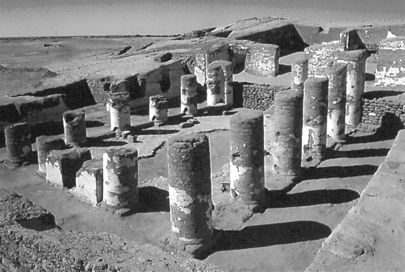
The intention to enhance the spatial experience is even more evident in the construction of the Large East Church (20 m x 17 m) (Figures 2 and 4). Numismatic evidence suggests this purpose-built basilica, the earliest known in Egypt, was founded before Constantine died in 337.Footnote 45 The church has three doors – two double and one single – and the central doors probably served as the clergy’s processional route.Footnote 46
The Large East Church: the nave and north aisle, looking south-west; from Gillian Bowen, ‘The Christian Monuments of Kellis’, 84 (plate II.27). Copyright: Colin A Hope and Dakhleh Oasis Project. Photo: Colin A. Hope.

The Large East Church features a four-sided ambulatory defined by a four-sided mudbrick colonnade. While Egyptian churches followed the same basic ground plan as three or five-aisled basilicas elsewhere, they also incorporated a complete ambulatory. This ambulatory, formed by lateral aisles joined to transverse aisles, created a distinctive walkway encircling the nave.Footnote 47 Ambulatories are a recognized feature of the traditional Roman basilica forensic, or a forum-style basilica, a form that appears to have been adopted in church construction in several parts of Egypt.Footnote 48
The church was accessed via a short flight of steps leading down to the return aisle, a feature that may have held liturgical significance (perhaps related to processions) by the fourth century.Footnote 49 Mudbrick bases and gouges in the columns suggest that wooden screens, at least one metre high, partitioned the lateral ambulatory aisles and the northern section of the return aisle (Figure 4).Footnote 50 These screens predate the previously known earliest examples from the Eastern empire and North Africa by 125 years.Footnote 51 There is no substantial evidence that fourth-century congregations were confined to the lateral aisles, suggesting that these screens perhaps served a decorative purpose, rather than dividing the room.Footnote 52 A screen of undetermined height once stood across the apse’s entrance, identifiable now only by its emplacement. Like the fastigium of the Lateran Basilica in Rome, it potentially restricted the congregation’s view of the sanctuary and, consequently, their experience of the eucharistic action.Footnote 53 The screening in the Large East Church was clearly an intentional and significant factor of its design. The division of space created by this screening, aesthetic or otherwise, will inevitably have restricted access and sightlines and, consequentially, influenced the spatial experience of worship. Screening might have created a sense of mystery within the eucharistic liturgy, but it might equally have created a sense of spatial exclusion or detachment for the laity in the nave.
An ambo or chancel, a raised platform for reading and preaching, stands in front of the main doorway, built against the western colonnade’s single column. Although only an outline remains, a semi-circular component of the ambo that projected into the nave suggests this was originally an elaborate structure (Figure 5).Footnote 54 Oriented towards the nave, this feature would have enhanced the spatial experience of the laity by making the proclamation of Scripture and preaching more directly accessible and audible to those assembled in the nave.Footnote 55 The addition of an ambo suggests an attempt to make aspects of the eucharistic liturgy more accessible, which might be interpreted as reflecting a balance between maintaining sacred boundaries and ensuring a level of inclusivity in worship.
Kellis, The Large East Church: column 2A and the chancel (ambo); from Gillian Bowen, ‘The Christian Monuments of Kellis’, 85 (plate II.29). Copyright: Colin A. Hope and Dakhleh Oasis Project. Photo: Colin A. Hope.

A pair of mudbrick pedestals at the eastern end of the nave, covered with oil residue and positioned directly in front of the bema (a raised platform associated with the sanctuary area), suggests a ceremonial function, though their precise purpose is uncertain.Footnote 56 These pedestals may have served as tables for the laity’s offerings to be selected and blessed for the eucharist.Footnote 57 Given the central location of these pedestals at the nave’s eastern end, directly in front of the bema, they possibly played a role in the laity’s experience of the eucharistic liturgy. We know regrettably little about the laity’s expectations regarding their ability or inability to view the ritual performed in the sanctuary, but if the screen obstructed the laity’s view of the sanctuary, these pedestals may have been one of the few significant points for the laity’s interaction with the liturgical action of the eucharist, bridging the division, both real and perceived, between the laity and the sanctuary.
The eastern transverse aisle, combined with the placement of two stone steps on either side of the platform, influenced the processional approach to the apse. Instead of accessing the apse from the front, it was approached via these steps on either side of a platform projecting into the transverse aisle. Access from the west end remained possible through the eastern end of the nave, which lacked a screen. However, the placement of these steps suggests the possibility that the lateral and transverse aisles forming the ambulatory might have served a processional function. The incorporation of an ambulatory at Kellis, as well as elsewhere in the Dakhleh Oasis and other parts of Egypt, suggests the possibility of a localized adaptation of the processional liturgy associated with the Constantinian basilicas.
Rooms 5a and 5b may have served as the church’s narthex, or vestibule, where catechumens usually received instruction before baptism. Catechumens probably used the double-doored entrance from the courtyard, while the entrances in Room 5b may have been reserved for the clergy and the baptized.Footnote 58 The Large East Church appears to have incorporated specific areas, access points and routeways intended for different echelons of the community. Entrances appear to have been designated according to the ecclesial status of clergy, laity and catechumens. Entrances reserved for clergy will also have emphasized ecclesiastical hierarchy. How, where and when one entered a Christian sacred space had experiential implications for every worshipper. The design and positioning of entrances and the division of sacred space based on ecclesial status and ritual considerations were clearly as significant considerations at the frontiers as they were in major ecclesiastical centres. While individual reactions to this are challenging to discern or interpret, the very presence of distinct entrances probably impacted a person’s sense of status within the community, creating a variety of spatial experiences of worship, not least those of inclusion or exclusion.
No evidence indicates the presence of a baptistery at Kellis or elsewhere in the Dakhleh and Kharga Oases. Although bishops had traditionally reserved the celebration of baptism to themselves, from the fourth century onwards, there is evidence that priests increasingly conducted baptisms, leading to the construction of baptisteries in both rural and urban settings, albeit not usually as separate buildings.Footnote 59 Fourth-century wooden tablets from Kellis mention a bishop (episkopos), but it is unclear whether a bishop resided there.Footnote 60 Given the absence of unexcavated structures near the east churches that could have served as a baptistery and a complete lack of evidence for baptisteries throughout the villages and small settlements of the oases, it is more plausible that the bishop resided in Mothis (modern-day Mut al-Kharab) and that catechumens from Kellis and other Dakhleh settlements travelled there for baptism.Footnote 61 As the capital of the oasis during the fourth century, Mothis was an episcopal see and had at least one church serving its dependent villages and settlements.Footnote 62
The mudbrick West Church Complex (7.4 m x 5.3 m), located on the edge of the settlement, comprises a church, a western outer room and six additional rooms integrated as a unit (Figure 6). Numismatic evidence indicates that the church’s construction dates to the mid-fourth century, with a possible terminus post quem before 340.Footnote 63
Kellis, The West Church Complex, looking south-east; from Gillian Bowen, ‘The Christian Monuments of Kellis’, 268 (plate III.1). Copyright: Colin A. Hope and Dakhleh Oasis Project. Photo: Colin A. Hope.

The sanctuary area features an apse flanked by two pastophoria. The bema, positioned at the front of the nave and in front of the centre of the apse, was accessed from the west by two steps, with additional steps on either side of the bema leading to the sanctuary. There is no evidence that the sanctuary was screened.Footnote 64 In the nave, two pit graves, probably fourth century, were discovered near the sanctuary, suggesting that the church served a funerary purpose.Footnote 65 This theory is supported by the presence of a small Christian cemetery with nine graves within an enclosure to the east.Footnote 66 All the graves were simple pit burials aligned with Christian east-west orientation, with the head aligned to the east.Footnote 67 The cemetery enclosure also incorporated two tombs in classical style, with one, West Tomb One, reused for eleven secondary burials, all oriented in the Christian east-west alignment. This reuse suggests that the Christian community at Kellis regarded these individuals as Christians, possibly even attributing to them a particular sanctity. Consequently, burial in proximity to these tombs may have been believed to confer an element of sanctity or protection.Footnote 68
The graves in the West Church were identified as those of a male and an infant.Footnote 69 The only other known funerary church in the Dakhleh Oasis is at Trimithis (modern-day Amheida), also from the fourth century, which contained eight burials.Footnote 70 Understanding the spatial experiences of worshippers and mourners in this space is challenging because a specific Christian burial liturgy did not exist before the seventh or eighth centuries.Footnote 71 However, the presence of pit graves within the church and in the nearby cemetery enclosure suggests a community engaged in honouring their dead, possibly attributing special sanctity to this site.
The West Church Complex may have initially served as a private chapel for the celebration of the eucharistic liturgy, where intercessory prayer for the dead would have been an element. It may have only later accommodated burials and memorial meals (refrigeria) associated with the dead.Footnote 72 Regardless of its precise functions, its existence as a funerary church, with its dual role as a place of worship and burial, reinforces the significance of Christian burial sites and the commemoration of the dead, paralleling the practices associated with cemeterial churches elsewhere in the empire, not least in the cemeterial churches above the Roman catacombs.
The churches of Kellis offer valuable insights into the spatial experience of early Christian worship, ritual and commemoration at this periphery of the Roman empire. The architectural evolution of these churches reveals a refinement of sacred space that shaped the experience of space and worship. The spatial developments observable in the Kellis churches provide insights into how early Christians in the Dakhleh Oasis adapted and refined their sacred spaces to enhance the experience of space, worship, ritual and commemoration. These appear to have been as significant on the empire’s boundaries as in its metropolitan cities.
Case Study 2: Nisibis, Mesopotamia
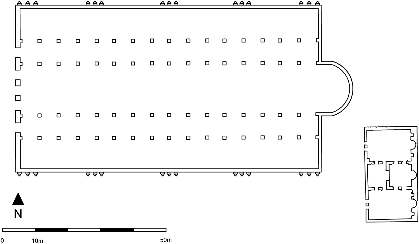
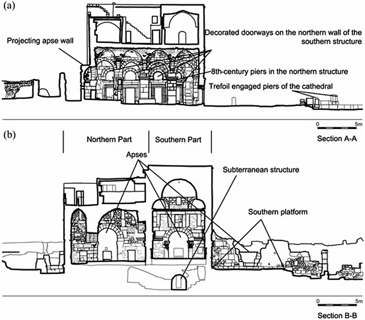
Nisibis (modern-day Nusaybin in Turkey) was a key military and commercial hub on the Roman-Sassanian (Persian) border. Epigraphic evidence indicates the presence of Christians at Nisibis by the early third century.Footnote 73 Bishop Jacob (Mar Yaqub) of Nisibis is traditionally credited with building a cathedral between 313 and 320, but it is likely that his successor, Volagesos, built the cathedral discussed here c.359, on the site of Jacob’s earlier church. The Byzantine monk and ascetical writer John Moschos (c.550–619) described the cathedral as having five doorways in a portico, suggesting a five-aisled structure with a courtyard.Footnote 74 Though excavation of the basilica is incomplete, and its precise date and full extent are unknown, partial excavation has revealed the foundations of a five-aisled building approximately 90 m x 50 m, a genuinely monumental church given its early date (Figure 7).Footnote 75
Nisibis, Reconstruction of the Cathedral as a five-aisled basilica and the Baptistery as a three-hall structure; from Elif Keser-Kayaalp and Nihat Erdoğan, ‘The Cathedral Complex at Nisibis’, 142 (figure 7). Copyright: Elif Keser-Kayaalp and Nihat Erdoğan. Plan credit: Elif Keser-Kayaalp.

Despite uncertainties in its architectural details, it is clear that the cathedral was designed on a scale resembling that of the Constantinian basilicas in Rome and the Holy Land. Its five-aisled basilical hall would have provided an impressive experiential ‘theatre’ for both the participants and observers of the processional liturgies for which such a massive building was so well-suited. The cathedral’s monumental scale suggests a well-established Christian community situated on a key route for both pilgrimage and trade. When Egeria visited Edessa, she wrote that she was within ‘five staging posts’ of Nisibis. During periods of peace, it is probable that large numbers of Christians from Sasanian Persia passed through the city.Footnote 76
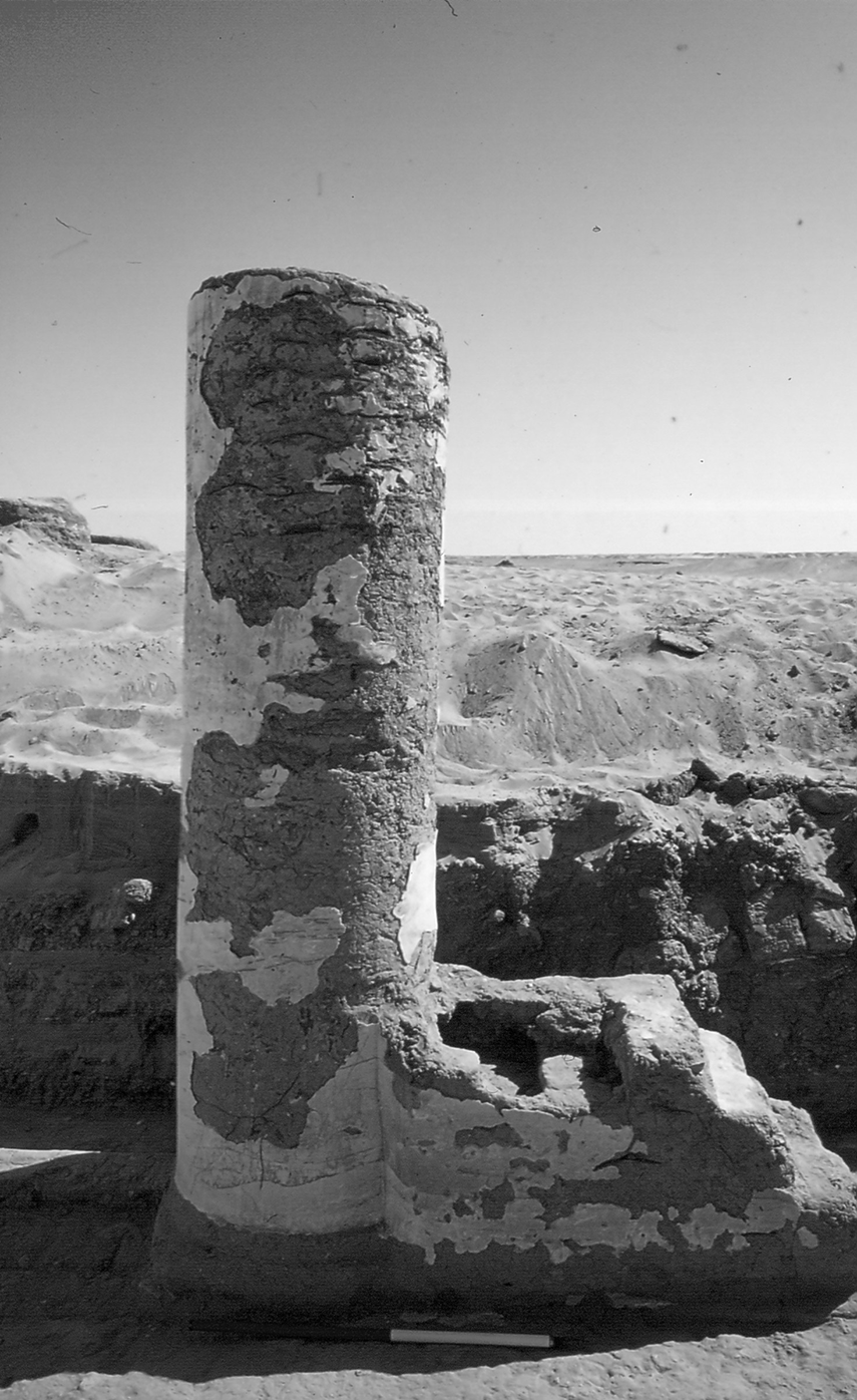
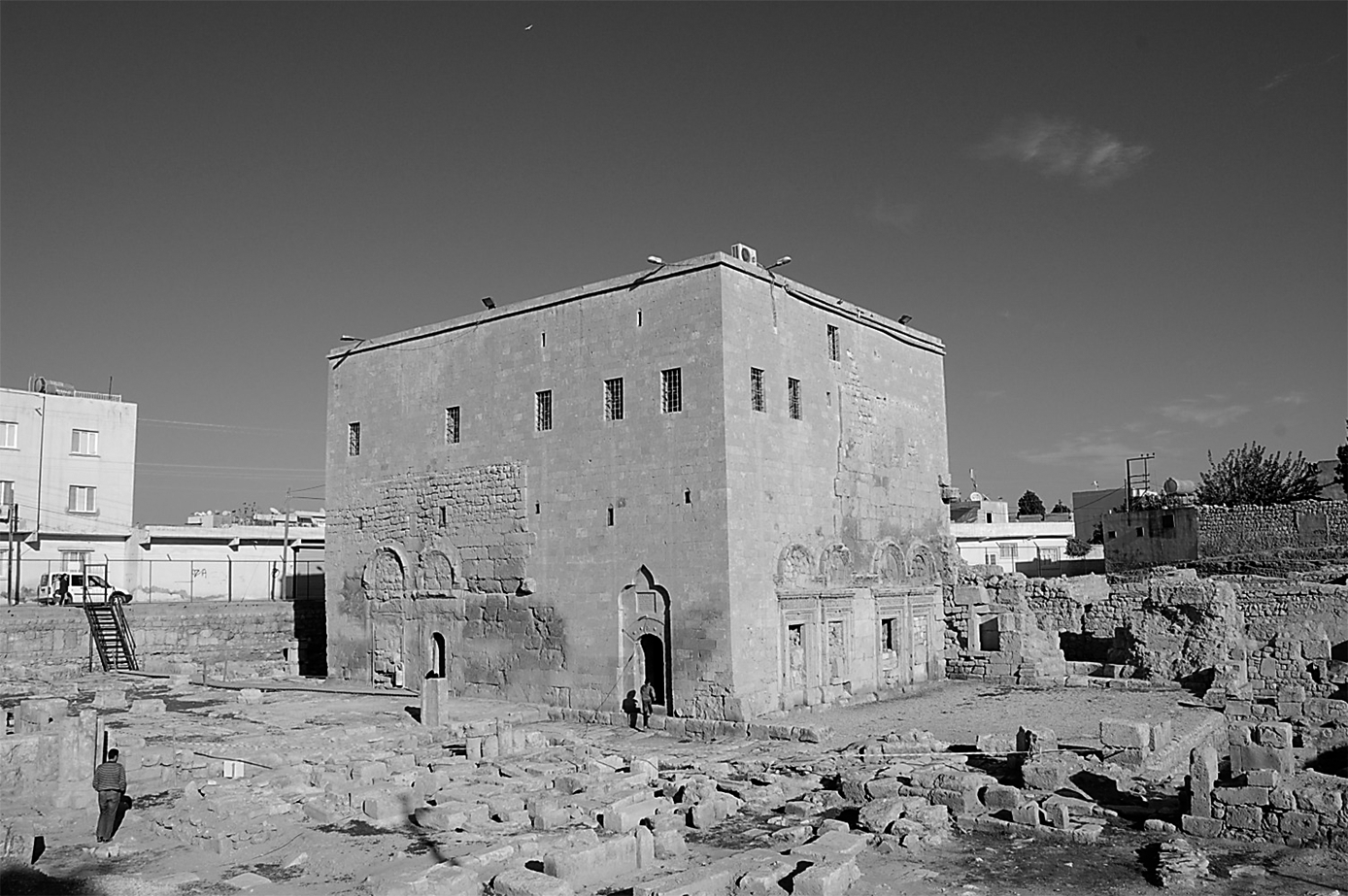
Today, although only the cathedral’s foundations remain, the nearby so-called Church of St Jacob is contemporaneous with the basilica (Figures 8 and 9).Footnote 77 Originally a triple-hall building, it now comprises only the northern and central sections. An in situ inscription from 359 identifies this edifice as a baptistery.Footnote 78 The central section was probably the actual baptistery, with the northern and southern spaces serving as integrated spaces with direct access to the baptistery.Footnote 79 These areas may have been used for elements of the baptismal rites, such as the administering of the pre-baptismal oil of catechumens and the provision of a space for catechumens to disrobe before baptism. As with other baptisteries, the exact arrangement and function of each room remain uncertain.Footnote 80 Beneath the eastern part of the original central structure (now the southern section) is a cistern-like crypt now containing Bishop Jacob’s sarcophagus, possibly relocated here after the cathedral’s destruction.Footnote 81 It has been proposed that catechumens may have descended into and ascended from this crypt during the baptismal ceremonies in a ritual representing the baptismal theology of dying and rising, and the womb of rebirth.Footnote 82
Nisibis, the Western and Southern Facades of the standing of the Church of St Jacob (Mor Yakub); from Elif Keser-Kayaalp and Nihat Erdoğan, ‘The Cathedral Complex at Nisibis’, 143 (figure 8). Copyright: Elif Keser-Kayaalp and Nihat Erdoğan. Photograph credit: Elif Keser-Kayaalp.

Nisibis, the Church of St Jacob (Baptistery): sections of the two storeys (the upper floor is a modern addition); from Elif Keser-Kayaalp and Nihat Erdoğan, ‘The Cathedral Complex at Nisibis’, 145 (figure 7). Copyright: Elif Keser-Kayaalp and Nihat Erdoğan. Plan credit: Elif Keser-Kayaalp.

An often-overlooked aspect of the baptismal ritual was the post-baptismal procession from the place of baptism to the basilica, where the neophytes would for the first time join the congregation to partake in the eucharist. Before baptism, catechumens were excluded from the eucharistic liturgy, making their post-baptismal entry into the cathedral particularly significant. Egeria’s account of the Easter vigil in Jerusalem vividly captures the power of this transitional moment, describing how the newly baptized were ceremoniously led by the bishop from the baptistery to the site of Christ’s tomb in the Holy Sepulchre, prior to returning to the martyrion basilica to participate in the eucharist.Footnote 83 This processional movement was probably a key element of the post-baptismal ritual in Nisibis as well, reflecting how sacred space could be ritually utilized.Footnote 84 In what would have been the grand, candlelit, colonnaded basilica of Nisibis, the experience for the neophytes in white baptismal robes processing to receive the eucharist for the first time must have been equally powerful, highlighting the potential of monumental sacred space to enhance the experience of ritual.
The Christian sacred spaces at Nisibis reveal a connection between architectural design and spatial experience. The monumental basilica, with its expansive five-aisled layout, would have enhanced the ritual experience by creating a grand setting for processions. As in the Kellis Large East Church, this grandeur was probably both aesthetic and functional. However, unlike at Kellis or the Lateran Basilica in Rome, no record or archaeological evidence for the church’s interior furnishings has been discovered which could shed light on how this vast space might have been further partitioned and decorated, limiting a further consideration of the possible impact of other elements of the architecture and decoration on the spatial experience of the basilica’s interior. The baptistery, with its distinctive architectural features, illustrates the increasing importance given to baptismal ritual from the fourth century onward. The potential ritualistic use of the crypt demonstrates how physical spaces could symbolize important theological concepts. Both the basilica and the baptistery in Nisibis show how early Christian communities used architecture to enrich their expressions of worship and theology. These spatial elements transformed architecture into an active participant in the experience of sacred space, shaping and reflecting the community’s experience of the sacred.
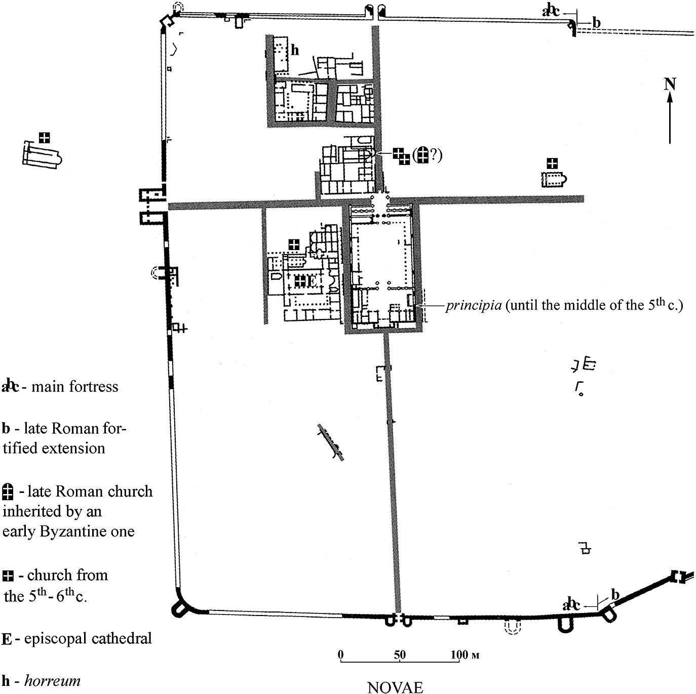
Case Study 3: Novae, Moesia Secunda
The legionary fortress and late antique town of Novae, located near Svištov on the Danube in north-western Bulgaria, offers some of the earliest reliable evidence for Christianity’s expansion along the Lower Danube, dating from the second half of the third century and the beginning of the fourth. Novae is believed to have been a site of persecution, with the martyrdom of St Luppos at Novae probably taking place as a result of the Diocletian edicts of 303–4.Footnote 85 The Byzantine historiographer Theophylact Simocatta (d. c.640) confirms that the commemoration of Luppos was important in late antique Novae. Simocatta recounts how Peter, the brother of Emperor Maurice (r. 582–602), was urged by the citizens of Novae to stay in the town for the celebration of the martyr’s festival.Footnote 86
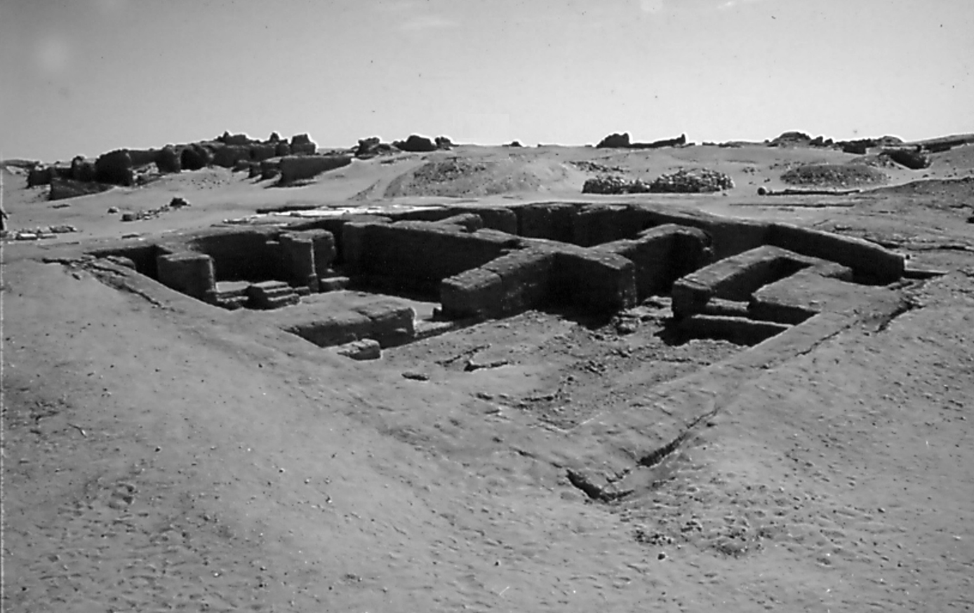
Excavations at Novae have revealed four late-fourth- or fifth-century churches inside the town walls and one cemeterial church just outside them (Figure 10). Basilica One (25.5 m x 15 m), the earliest, is a single-apse, three-aisled church with a narthex.Footnote 87 Basilicas Two (26 m x 15.6 m) and Three (31 m x 15.6 m), constructed one on top of the other, are also single-apse, three-aisled churches with a narthex, the latter being the larger and later. Their similar architectural features suggest a construction date in the mid-fourth to early fifth century.Footnote 88 The spatial distribution of the basilicas around the town may imply a parochial function, serving the town’s local communities.Footnote 89 A detailed analysis of these three basilicas is challenging since the archaeological reports have not been published.Footnote 90
Novae, Plan of Late-Antique Novae, showing the location of the fifth and sixth-century churches; from Ventzislav Dintchev, ‘Town and Church in Late Antiquity: Architectural and Urbanistic Dimensions’, in Lyudmil Vagalinski et al., eds, Proceedings of the First International Roman and Late Antique Thrace Conference ‘Cities, Territories and Identities’ (Sofia, 2018), 357–70, at 362 (figure 7). Copyright: Ventzislav Dintchev. Drawing credit: Ventzislav Dintchev.

North-west of Novae, a fifth-century three-aisled, single-apse basilica (20.8 m x 13.3 m), with a narthex probably added in the sixth century, is associated with a Christian necropolis containing over sixty graves and reminiscent of the West Church Complex at Kellis.Footnote 91 Evidence from the late fourth and early fifth centuries elsewhere in the empire suggests that by then some communities were holding funerary rituals for prominent individuals inside church buildings. Gregory of Nyssa (c.335–c.394), in his account of the funeral of his sister, Macrina, recounts how the church vestibule could not accommodate the gathered crowd. He describes the community’s overnight vigil, during which they sang hymns and psalms around her body.Footnote 92 It is notable that the church served as the space for these rituals, which were choreographed by Gregory as the bishop.Footnote 93 The cemeterial basilica at Novae may have also served a commemorative function, potentially housing the relics of St Luppos in a tomb in the apse. It is possible that in the early fourth century Luppos was initially buried in the necropolis, with a martyrium subsequently built over his grave. The potential development of Christian worship in Novae, centred around the necropolis and its cemeterial church, seems to parallel the practice and experience of worship and commemoration as well as the tradition of ad sanctus burials observed in the suburban cemeterial basilicas and catacombs outside Rome.
In the fifth century, the simple martyrium may have been replaced by the cemeterial basilica, with the altar situated above Luppos’s tomb. The relics of St Luppos may have been transferred to a martyrial chapel within the episcopal basilica in the late fifth or early sixth centuries.Footnote 94 Prior to the late fifth century, burials within churches inside the walls of towns and cities were largely forbidden, and although the observance of this ban became somewhat more flexible, the practice remained unusual.Footnote 95 Accordingly, if Luppos’ body were indeed transferred to the episcopal basilica, this would have been a rare and exceptional event, significantly elevating the sanctity of the episcopal basilica and establishing it as a place of veneration and pilgrimage. While the saint’s relics were not the primary focal point of the basilica, their translation may have shaped ritual practices, especially on the saint’s feast day, when a procession to the martyrial chapel could have formed an important element of the celebrations.Footnote 96 The significance attached to the relics of St Luppos and their possible translation to the episcopal basilica highlights how the cult of saints played a role in the articulation and shaping of sacred space.Footnote 97
Novae’s episcopal basilica (40.26 m x 22.32 m), a three-aisled church with a single apse and a narthex, ranks among the largest basilicas on the middle and lower Danube dating to this period.Footnote 98 Archaeological evidence indicates that it was constructed and modified in phases from the late fourth to late sixth century.Footnote 99 Besides the possible martyrial tomb for St Luppos, the discovery of another burial vault within the basilica provides evidence for intra-ecclesial burial in funerary churches in this period, reminiscent of the situation observed at West Church Complex in Kellis.Footnote 100
In the atrium of the episcopal basilica was a freestanding baptistery (7.4 m x 5.05 m), probably added in the last quarter of the fifth century.Footnote 101 The baptistery featured a baptismal basin or tank, accessible by dual stone steps on its east and west sides, and was adorned with marble slabs. The tank is rectangular in shape, inscribed within a circle with an internal diameter of 1.65 meters. As a result, the overall layout of the tank complex has a hexagonal floor plan. The hexagon may have symbolized Christ’s death on the sixth day, while the circle may have represented the womb of new birth, reflecting the baptismal theology of dying and rising.Footnote 102 However, the cautionary caveat offered in the discussion of the Nisibis baptistery concerning the theological interpretation of the shape of baptisteries should be kept in mind.Footnote 103
Positioned in the atrium, the baptistery offered a direct route for catechumens arriving from the west and facilitated their processional movement to the basilica after baptism. Two of the three doorways may have been designated for catechumens and neophytes, marking their entry and exit, while the third was perhaps reserved for the bishop and clergy.Footnote 104 The possible creation of entrances and exits for specific echelons of the community to be used at specific ritual moments highlights the significance of the spatial experience of sacred space, similar to the Large East Church at Kellis, and probably reinforced ecclesiastical status and precedence. As at Nisibis, the spatial transition from the baptistery to the basilica at Novae was probably an important element of the baptismal experience. The neophytes’ ascent from the baptismal basin symbolized their spiritual rebirth. Passing through designated doorways – perhaps one designated specifically for their exit from the baptistery and entry into the main basilica – ritually and symbolically reinforced their transition from catechumens to full members of the Church. The strategic placement of the baptistery relative to the basilica demonstrates how sacred spaces were adapted to enhance the sanctity of worship and reinforce hierarchical, ecclesial and communal identities.
As at Kellis and Nisibis, the spatial arrangement and architectural features of Novae’s basilicas and the external baptistery reflect the Christian community’s evolving ritual and commemorative practices. Novae’s sacred architecture not only facilitated but actively shaped the practices of worship, ritual and commemoration of its Christian community, reflecting broader trends in early Christian worship across the empire.
Case Study 4: Vindolanda, Britannia Secunda
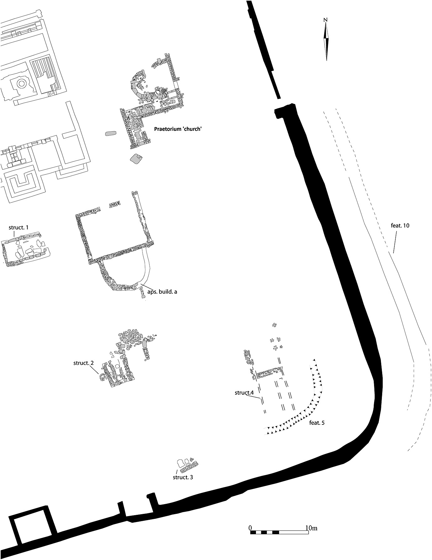
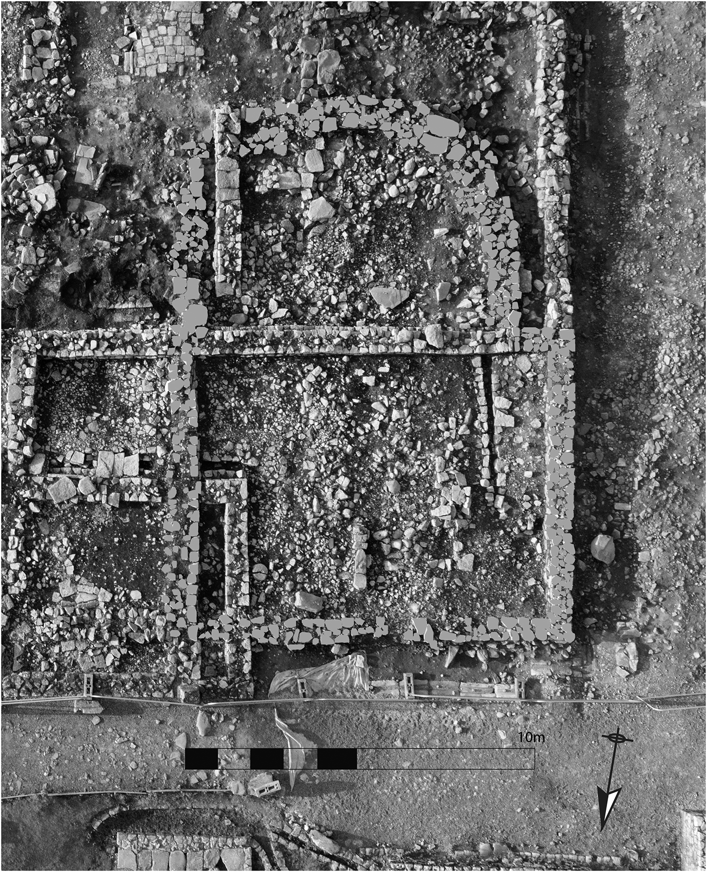
On the frontier in Britannia Secunda, northern England, along Hadrian’s Wall, potential churches have been identified at the forts at South Shields, Housesteads and Birdoswald.Footnote 105 Most notably, at Vindolanda, the apsidal design and dating of several structures from the sub-Roman (409–600) and post-Roman (600–800) periods indicate the possibility of up to five early Christian churches (Figure 11). However, as Andrew Birley and Marta Alberti observe in their report of the excavation, the evidence is ‘extremely fragmentary in nature and much debated’.Footnote 106
Vindolanda Fort, the sub-Roman buildings in the south-eastern quadrant as they would have appeared in period IXA (the sub-Roman period), c.409–600 CE; after Andrew Birley and Marta Alberti, Vindolanda Excavation Research Report, 40 (figure 23). Copyright: Vindolanda Trust. Plan credit: Marta Alberti for the Vindolanda Trust.

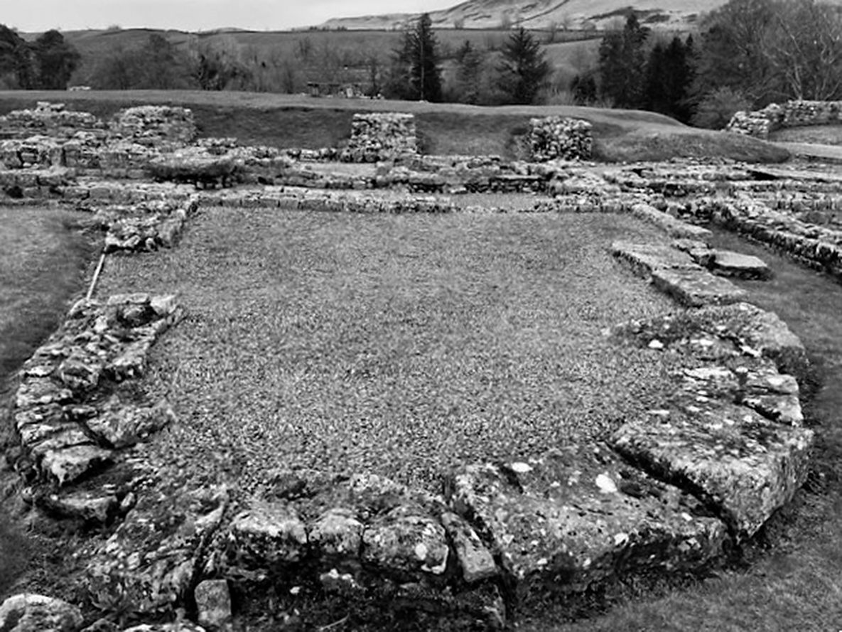
Excavations have revealed that the demolition of three of the four wings of the praetorium (commanding officer’s house) around the 360s or 370s would probably have rendered it uninhabitable, with the commanding officer and his family perhaps taking up residence in the principia (headquarters building). In the southern part of the praetorium courtyard and the remains of the east wing, a ‘church-like’ structure with an apse was built (Figure 12).Footnote 107 Stratigraphic evidence indicates that this structure was erected some time after the alterations undertaken c.360–70. The date of construction of the praetorium ‘church’ (6.5 m x 3 m nave, with a 5 m diameter apse) remains uncertain, but can be estimated at c.400 or shortly thereafter.Footnote 108 There is debate regarding the nature and purpose of the alterations to the praetorium. One recent counter-argument to the ‘church’ theory is that the apsidal structure could have served as an extension of the eastern wing of the praetorium into the courtyard, perhaps functioning as a reception room, and compensating for lost rooms due to deterioration elsewhere in the praetorium. Footnote 109
Vindolanda, the praetorium ‘church’. © The author.

The praetorium ‘church’, like other sub-Roman structures at Vindolanda, generally adhered to the pre-existing layout.Footnote 110 Only a single course of masonry remains, leaving the nature of the upper structure, whether timber or stone, uncertain. The excavators currently consider a part-stone, part-timber construction more probable.Footnote 111 Just inside the building’s entrance, an altar dedicated to Jupiter and the genius of the praetorium was repurposed as a paving stone. With its inscribed side facing downward, it perhaps represented a deliberate religious and ceremonial act symbolizing the triumph of Christianity. The praetorium ‘church’ probably remained in use throughout the sub-Roman period.Footnote 112
Another apsidal building, referred to as ‘Apsidal Building A’ (8.7 m x 11 m nave-like space, with a 9.3 m diameter apse), was discovered within a fourth-century cavalry barracks (Figures 11 and 13). This structure, also interpreted as a possible church, features a semi-circular apse and a square nave, with numismatic evidence providing a terminus post quem for the laying of the apse’s foundation of c.364–78. Like the praetorium ‘church’, there is no evidence of subsequent modifications, suggesting that it may have been abandoned only at the end of the post-Roman period.Footnote 113
Vindolanda, the stone-by-stone plan of the foundations of Apsidal Building A (shaded in grey), overlaid with an aerial photo by Aerial Cam. © The Vindolanda Trust. Photo credit: Marta Alberti for the Vindolanda Trust.

Significant parallels exist between Apsidal Building A and the praetorium ‘church’, particularly in their incorporation of pre-existing fourth-century masonry to transform square rooms into nave-like spaces. In addition, their foundations rest directly above demolished fourth-century contexts; the apse walls are constructed of facing stones; and the apses are set slightly off-centre with the naves to create a basilical-type layout.Footnote 114 These similarities suggest a consistent construction pattern and a level of continuity in architectural development at Vindolanda in the sub-Roman period.Footnote 115
The spatial experiences for worship and ritual in these two modest buildings would inevitably have been simpler than the sacred spaces of Kellis, Nisibis and Novae. The diminutive size of the Vindolanda structures would have limited the potential for spatial division and distinct entrances and routeways. Nevertheless, the attempt to replicate the basilical shape of Christian sacred space, even on a modest scale, is significant, perhaps reflecting a desire by the Vindolanda community to incorporate elements of Christian architecture and the rituals associated with it, as known from other regions.
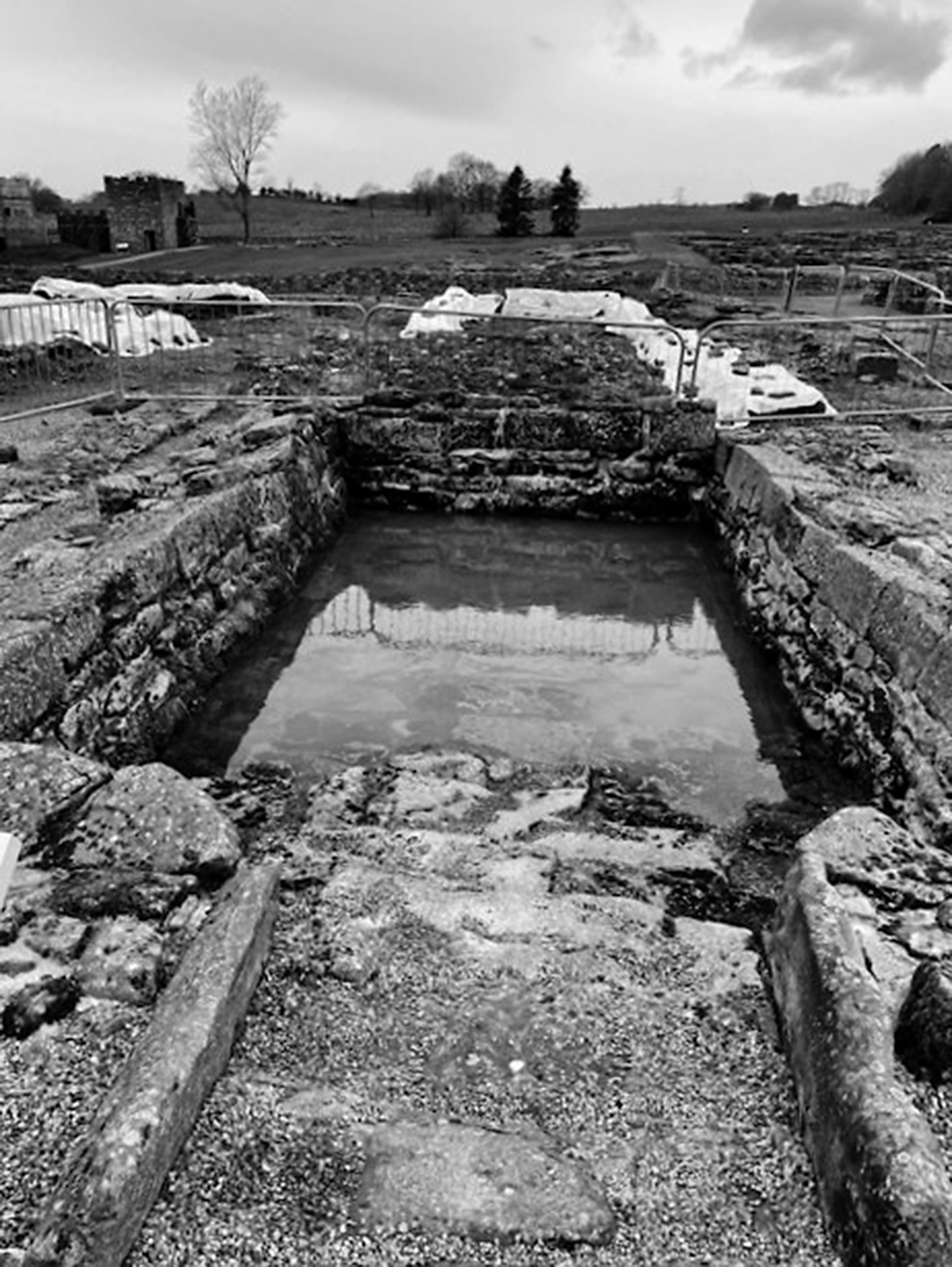
Nearby, an originally third-century rectangular building was demolished in the fourth century, and part of its outer wall was repurposed into a rectangular water tank clad with well-cut, reused ashlar sandstone blocks (Figure 14). A smaller flagstone-floored space in front of the main tank extended into the street, forming an access point for drawing water.Footnote 116 By the end of the fourth century, the tank seems to have been converted into a roofed building with numismatic evidence suggesting a terminus post quem of 321–23 for its construction.Footnote 117 This modification may have corresponded with the creation of a walk-in water tank capable of both practical and ritual use, with access to the water enhanced by levelling the eastern wall and adding a step. This tank would have been contemporaneous with the praetorium ‘church’ and possibly the Apsidal Building A.Footnote 118
Vindolanda, the water tank was possibly converted into a baptismal tank/font and was perhaps associated with the praetorium ‘church’ and Apsidal Building A. © The author.

The interpretation of the water tank as a baptismal tank or font is speculative, but plausible. As at Kellis, catechumens at Vindolanda possibly went elsewhere for baptism. However, despite its much simpler design compared to the ornate baptisteries at Nisibis and Novae, the tank’s enclosed structure, convenient stepped access, and its proximity to both the praetorium church and Apsidal Building A suggest that it could have served as a site for the baptismal rituals. Such an arrangement would have also allowed for the possibility of a short post-baptismal procession to either of the adjacent proposed churches.
Interpreting the water tank as a potential baptismal font raises the question of who might have performed baptisms at Vindolanda. As noted above in relation to the absence of a baptistery at Kellis, evidence from the fourth century onwards suggests an increase in baptisms performed by priests and the construction of small, though usually not separate, baptisteries in rural areas.Footnote 119 This trend may inform our understanding of the water tank at Vindolanda, suggesting its potential for functioning as a place for the celebration of baptism.
At the beginning of this case study, it was noted that evidence for ecclesiastical structures at Vindolanda is both fragmentary and debated. While the praetorium ‘church’ and Apsidal Building A cannot be definitively confirmed as churches, evidence from post-Roman buildings and material culture supports the interpretation that they were. Although Vindolanda’s Christian context may not be as clear-cut as sites such as Kellis, Nisibis or Novae, the cumulative evidence makes a compelling case for a Christian presence.
Two further structures – Apsidal Buildings B and C – deserve mention, even though they fall outside the chronological scope of this article. Stylistic analysis suggests that these buildings belong to the post-Roman period, and they may represent a new type of church-like structure with an elongated, ‘rocket-shaped’ apse and rectangular nave.Footnote 120 If this identification is correct, it indicates a significant new phase in the development of Christian sacred spaces within the fort, supporting the continuation of an already established Christian environment.
In addition to the excavated buildings, numerous artefacts excavated at Vindolanda strengthen the Christian interpretation of the site. These include stone carvings with Christian motifs, a portable altar stone incised with a chi-rho cross, and a copper alloy nail-cleaning strap-end decorated with a possible depiction of a figure in the orans position of prayer. This last artefact was found near Apsidal Building A. Additionally, a remarkable lead vessel covered inside and out with Christian symbols was excavated within Apsidal Building B.Footnote 121
Examining the architectural and spatial experiences of potential early Christian structures at Vindolanda reveals a complex and debated picture of religious transformation. Despite the fragmentary nature of the evidence, it suggests intriguing possibilities for the presence of Christian sacred spaces in this frontier community. Although alternative interpretations are possible due to the incomplete evidence and ongoing debates, these buildings, especially when considered alongside the Christian artefacts found on the site and the architectural continuity, suggest that they were structures which might well reflect an evolving experience of Christian sacred space at Vindolanda in the sub-Roman and post-Roman periods.
Conclusion
The study of fourth- and fifth-century spatial experiences associated with worship, ritual and commemoration in frontier settlements like Kellis, Nisibis, Novae and Vindolanda reveals the intricate relationship between architecture and religious practice. Constantine’s basilicas in Rome and the Holy Land marked a shift towards the centralization and monumentalizing of Christian worship, creating a template that influenced Christian sacred architecture, worship and ritual practice throughout the empire. At the frontiers, Christian sacred spaces followed trends from Rome and the Holy Land, whilst remaining adaptable to local innovations. Features such as basilical church layouts, cemeterial and funerary churches, designated entrances, processional routeways, screening and freestanding baptisteries illustrate how architectural innovations were tailored to fit local contexts. These sacred spaces integrated diverse worship, ritual and commemorative practices, demonstrating that flexibility in sacred architecture was as evident at the empire’s peripheries as at its core. The case studies highlight the dynamic relationship between sacred architecture and religious practice at the Roman frontiers, showing that the foundational model provided by the monumental basilicas of Rome and the Holy Land was dynamically reinterpreted rather than rigidly adopted, balancing continuity and innovation.
Future research would benefit from a more comprehensive, interdisciplinary approach to the study of the spatial experience of Christian sacred spaces and worship, ritual and commemoration, especially in frontier contexts. Further study of both similarities and divergences in the creation and experience of these spaces has the potential to yield further insights into how frontier Christian communities engaged with and experienced their sacred spaces. This is a field of Roman frontier studies that merits more attention.