
In 1891, the Utrecht pedagogue Evert Nijland (1854–1909) published a magnificent missionary map of the Dutch East Indies.Footnote 1 A school director of the Utrecht Dutch Reformed School as well as member of the board of Utrecht Missionary Society, Nijland was a keen amateur geographer and ethnologist and also produced a series of school plates with depictions of everyday life in the Dutch East Indies.Footnote 2 The map showed the Dutch East Indies archipelago and marked the activities of missionary societies as well as the administrative centres of the colonial government. Believing the map to be of ‘general Dutch interest’, Nijland solicited the Dutch government to adopt and rework the map to become ‘the schoolmap of the Indies’.Footnote 3
Nijland's colonial and missionary map is a fine example of how in the nineteenth century mission and empire were perceived to be symbiotic, and as such supports a long-standing view prevalent in postcolonial scholarship.Footnote 4 Over the last decade, however, in British revisionist historiography a more complex picture has emerged about their relationship. Many missionaries saw empire as a divine opportunity to spread the Gospel, but precisely for this reason they could be critical of empire when it hindered rather than facilitated the spread of the Gospel.Footnote 5 For the goal of mission was not to establish empire but to extend the kingdom of God. Although the colonial government recognised the uses of mission, it initially rather impeded and later regulated missionary efforts. Revisionism invites historians to refocus the debate and question the paradigm of mission as a function of empire. As Andrew Porter has stated with regard to nineteenth-century British mission, ‘Although missions could not avoid empire, they were determined to put it in its place.’Footnote 6 This ties in with the historiography on the cultural impact of empire, the central point in the Porter-MacKenzie debate. Bernard Porter argued that the British Victorian public was largely unacquainted with empire, whereas historians such as Catherine Hall and John MacKenzie, contrariwise, argued that British society and culture were saturated with empire.Footnote 7 To what extent did ordinary people identify or concern themselves with empire?
In The Netherlands the historiographical debate about the tangled relationship between empire and mission has simply not yet taken place. Indeed, in a historiographical overview of the Dutch debate on empire in 1998, Maarten Kuitenbrouwer ignored mission altogether. In his monumental 1998 overview of the Dutch East Indies, J. de Jong only fleetingly remarked on mission, and the same holds true for Jur van Goor's 1994 overview of the history of the Dutch colonies.Footnote 8 In 2013 Remco Raben, in a historiographical survey of Dutch colonial historiography, observed that ‘little work has been done on philanthropic and missionary societies in the Netherlands’.Footnote 9 In 2021, Maaike Derksen still noted that unlike in British historiography, ‘the role of Christian missions in the Dutch colonial past has hardly been acknowledged and the connection between missionary activity and colonialism has never been systematically and thoroughly problematized or researched’.Footnote 10
Even so, Dutch historiography yields a range of fragmented images of the relationship between mission and empire. Jur van Goor emphasised the somewhat paradoxical relationship between mission and the colonial government, but had relatively little to say about Protestant mission.Footnote 11 Robert Woodberry stressed the obedient attitude of Dutch missionaries in relation to their British counterparts.Footnote 12 However, Sita Thamar van Bemmelen emphasised how German missionaries were trailblazers of the Dutch empire in North Sumatra.Footnote 13 Maaike Derksen believed that Catholic missionaries were essential in the cultural colonisation of the Dutch East Indies.Footnote 14 No coherent picture arises from these observations, but perhaps Wim van den Doel's tentative conclusion comes closest to some sort of consensus. In his view, the relationship between the colonial government and Protestant missionaries was strained in the early nineteenth century but became more harmonious towards the late nineteenth and early twentieth centuries.Footnote 15 The paradox of the complex relationship between mission and empire is further clarified by Thom van den End, who argued that Dutch missionaries criticised aspects of colonial government but not so much colonialism or its civilising mission as such.Footnote 16 This view is congruent with the recent study of Matthijs Kuipers about popular imperialism in The Netherlands.Footnote 17
Since missionaries reported at length to the Dutch home front about their efforts, Van den End argued that ‘Mission was an important channel in The Netherlands for information about the Dutch East-Indies.’Footnote 18 In a programmatic historiographical survey in 2013 Remco Raben also believed that ‘In many ways, [missionaries] have been instrumental in informing a wider public in The Netherlands of the situation in the colonies, and instilling them with an emotional involvement with the situation overseas.’ In short, he proposed that missionaries ‘enhanced the imperial awareness in The Netherlands’.Footnote 19
The purpose of this article is to test Raben's proposition through the lens of missionary maps. The central question is: ‘Did missionary cartography support the extension of the Kingdom of God or the Dutch empire?’ As the Nijland map example shows, missionary maps are an excellent resource to study the relationship between mission and empire. Although missionary cartography is well-known to historians, a systematic study of this phenomenon is still lacking. In 1993 Ruth Kark pointed to this ‘reservoir of cartographical sources’ that remained unexplored.Footnote 20 Since then some research into missionary maps has taken place, but it has not led to an overview or deeper understanding of the phenomenon. In the context of the nineteenth and early twentieth centuries, these maps provide a window on European attitudes on the extra-European world and the relationship between mission and empire. As the Nijland map shows, missionary territorial claims could match colonial claims, suggesting a symbiotic relationship between empire and mission. At the same time, as Andrew Porter has stated, missionaries did not set out to establish an empire but to extend a kingdom. Recently Alec Ryrie and David Trim have argued that ‘missionaries and empires needed, exploited and manipulated each other. Their purposes might sometimes be aligned but were rarely very similar’.Footnote 21 A study of missionary cartography can help to understand this inherent tension in the missionary movement.
In order to operationalise the research question, the toolbox of ‘critical cartography’, which emphasises the nexus between maps and power, will be applied. At its core is the observation by the British geographer John Brian Harley that ‘maps are part of a visual language by which specific interests, doctrines and even world views were communicated’.Footnote 22 They represent the world in the light of specific interests. As David Storey has argued, ‘Mapping of territory itself functions so as to enhance power sending out messages signifying control over portions of geographic space.’Footnote 23 Denis Wood, in his ground-breaking Rethinking the power of maps, takes the argument even further, arguing that maps represent nothing but themselves: they are self-referential ‘systems of propositions’ about the world, a visual creation of symbols and figures that signify argument rather than place. A map has social power to the extent that ‘social assent [is] given to the propositions it embodies’.Footnote 24
The central question of this article will be tackled by a twofold analysis of both the ‘propositions’ of Dutch missionary maps and the ‘social assent’ these enjoyed. Dutch missionary societies started to produce missionary maps from about the middle of the nineteenth century, both world maps and maps of the colonial possessions (mainly the Dutch East Indies). This article follows the chronology of Van den End, who stated that the missionary movement gained critical mass around 1850 but changed direction in 1940 with the Second World War and the subsequent loss of the Dutch East Indies.Footnote 25 This article explores the social power of missionary maps in three parts. The first provides a bird's-eye view of missionary cartography in general and the Dutch missionary movement and maps in particular. The second tries to tackle the first issue, the ‘propositions’ of missionary maps. It is based on a selection of six popular Dutch missionary wall maps published between about 1850 and 1940. Such a longitudinal analysis may serve to nuance any monolithic conclusions and takes stock of Van den Doel's two-phase model of the entanglement between mission and empire. The third part deals with the second issue, the extent of ‘social assent’ attributed to these maps. This section draws from comments on the usage and perceptions of these maps found in missionary bulletins and magazines.
The unknown history of Protestant missionary maps
Although interest in historical cartography is currently booming, research on missionary maps has only recently gained traction and remains unsystematic.Footnote 26 There is currently no overview of the historical development of Protestant missionary maps. What follows is a tentative survey.
The emergence of the modern Protestant missionary movement in the last decade of the eighteenth century was invigorated with maps, visual embodiments of the focus and reach of global mission. Missionary maps started to appear with the advent of the modern missionary movement in the 1790s. A very early example are the maps reproduced in a missionary voyage of exploration, A missionary voyage to the Southern Pacific Ocean, performed in the years 1796, 1797, 1798, in the ship Duff, commanded by captain James Wilson. Footnote 27 By the mid-nineteenth century maps were maturing. The invention of chromolithography in 1837 facilitated the production of attractive full-colour maps. An exquisite example is The pictorial missionary map of the world by John Gilbert, published in 1861, a world map with colours indicating the world religions and cartouches with ethnological images.Footnote 28 Gilbert's map was echoed in the German Missions Welt Karte, a fairly similar design published by the Basler Mission in 1891.Footnote 29 The largest specimen was the mammoth linen map (1878) by the New York-based map-making firm J. H. Colton.Footnote 30
Missionary maps were part of the discipline of missionary geography, a term that was coined around 1825 and gained currency in the 1840s.Footnote 31 It was developed in the context of the rise of the science of geography as well as the ascendancy of European imperialism in the early nineteenth century with the establishment of the Société de Géographie in Paris (1821), the Gesellschaft für Erdkunde zu Berlin (1828), the Royal Geographical Society in London (1830) and the Koninklijk Nederlands Aardrijkskundig Genootschap in Amsterdam in 1873. Cartography played a part in the emerging curricula in schools, but also helped to consolidate the spatial features of the nation state.Footnote 32 Missionary maps informed the home front about the missionary enterprise, but also educated people about geography more generally. The Revd Daniel Crosby used a missionary world map in one of his lectures in Boston, but found that ‘Mercator's projection [was] not being easily apprehended by the people in general.’Footnote 33
There is as yet no set classification of missionary maps. Heuristically, it makes sense to make a distinction between wall maps, printed maps in books and periodicals and missionary atlases. Wall maps were primarily used on the lecture circuit. Travelling missionaries or preachers gave public presentations in town halls and churches in order to inform audiences and they needed large wall maps. For this purpose, Joseph Tracey's map of the world was published in 1843, ‘especially adapted for the use oe [sic] schools, geographical & historical lectures and missionary meetings’.Footnote 34 In 1842 the American Board of Commissioners for Foreign Missions (ABCFM) issued a favourable report ‘on the use of missionary maps’ in monthly gatherings, with an eye to inform and inspire the home front.Footnote 35 In 1846, the ABCFM stated that ‘The extensive use of these maps in lectures on missions and at the monthly concert of prayer, is doing much to diffuse definite information as to the condition and wants of the unevangelized world and the progress of evangelical missions, and to promote effort and prayer for the universal promulgation of the gospel.’Footnote 36
Wall maps were also used in schools and Sunday schools. The production of tailor-made maps for classrooms took off somewhere before the middle of the nineteenth century. Teachers were concerned with educating children about mission, but also about geography in general. The maps had different levels of sophistication, being fit for either primary or secondary schools or higher education.Footnote 37 A famous example is the massive missionary map of the world, made by the sons of the New York-based mapmaker Joseph Colton in 1878, printed on linen and based on a design Colton had made in 1845. That map was intended for Sunday schools, lectures and geography classes in school, and more generally to promote ‘the universal promulgation of the gospel’.Footnote 38
Maps were also folded and published in missionary bulletins and periodicals established to keep the support base of missionary societies informed. An early example is A map shewing the missionary stations throughout the world (1825), a simple black-and-white world map providing a listed overview of missionary stations worldwide. The map was folded into a book on world mission by a pastor from Vermont, Walter Chapin.Footnote 39 The educational function of such maps is evident from the children's missionary map published by James Nisbet in the Children's Missionary Magazine in 1843, a black-and-white map flanked by illustrations of the exotic animals of the world and ships carrying the Gospel.Footnote 40
Missionary atlases were suitable for the study room. These were sometimes commissioned by missionary societies, but quite often they were produced by independent scholars or ministers. One of the first atlases was published in 1839 by James Wyld.Footnote 41 The genre matured into an academic discipline through the work of the German missionary Peter Reinhold Grundemann (1836–1924) who produced several high-quality missionary atlases.Footnote 42 It reached a new level of thoroughness with the statistics-driven Missionary world atlas, published in the wake of the World Missionary Conference in Edinburgh in 1910.Footnote 43
The Dutch missionary movement and cartography
The modern Protestant missionary movement in The Netherlands emerged in the final decade of the eighteenth century in the wake of the establishment of the London Missionary Society in 1795. The first Dutch society, the Nederlandsch Zendelings Genootschap (NZG), was founded in Rotterdam in 1797. Because of the French occupation and the Napoleonic wars, the society was more or less inactive until 1814. With exceptions, until the early twentieth century the vast majority of Dutch Protestant missionaries were active in the Dutch East Indies. Dutch mission was not very successful on Java, but on the outer islands missionaries made some progress. Initially the colonial government was far from open to mission. The governor of Java curtailed mission in 1823, fearing that it would upset Islamic sensitivities. By the middle of the nineteenth century the colonial government had adjusted its position, seeing how missionaries sometimes were trailblazers for empire in the territories outside the central island of Java. In 1854 the Dutch government implemented article 123, which allowed both Protestant and Catholic missionaries to do their work, but only after receiving formal permission from the governor-general. The result was that each missionary society was allotted a territory in which it would neither encounter the dominant Muslim authorities nor compete with other missionaries. In the 1850s several missionary societies were established to spread out over the Dutch East Indies, but even so, as Wim van den Doel observes, ‘the resistance of Dutch governmental administrators was remarkable and their achievements small’. As a result some missionaries ventured out into territories in which the colonial government had not established a presence, such as on New Guinea. They encountered grave problems and asked the colonial government to expand and so ensure protection.Footnote 44
The monopoly of the NZG was broken in 1858 with the establishment of the Nederlandse Zendings Vereniging, which was dissatisfied with the liberal theological developments within the NZG. In 1859 the Utrechtse Zendings Vereniging followed, as well as a number of smaller societies. Some of these were also active outside of the Dutch colonies, such as in China and South America, thus colonialism and mission never completely overlapped.Footnote 45 Moreover, non-Dutch missions also entered the fray, such as the Rheinische Mission Gesellschaft (1869) and American Methodists (1904) on Sumatra, the Basel Mission Gesellschaft on Borneo, and the American Christian and Missionary Alliance in 1929.
In their quest for support and funding, missionary societies organised festivals which in The Netherlands attracted up to 15,000 people. They also established some 150 missionary periodicals between 1850 and 1940, with a total readership of about 50,000–100,000 at any one time.Footnote 46 It is a significant detail that the very first issue of Het Zendelingsblad voor de Jeugd [The missionary magazine for youth] had a simple missionary world map by Theodorus Looman as the frontispiece.Footnote 47 Next to such folded maps, wall maps started to appear in the 1850s. One of these was made in 1853 by Cornelis Elisa van Koetsveld (1807–93), a minister in the Dutch Reformed Church, author of religious books and court preacher to William iii from 1878. One year later a Christian missionary map of the world was made by J. A. Groen, consisting of eight separate coloured sheets.Footnote 48 The most sophisticated missionary map of the Dutch colonies was produced by Evert Nijland in 1891, the Missionary map of the East and West Indies.Footnote 49 For schools, the simplified maps of the Dutch East Indies made by Luijtjen Kupérus, secretary of the missionary Java Committee in 1911, and the Utrecht theologian Annéus Brouwer in 1930 were much more popular.Footnote 50 Brouwer's design in particular was simpler, including basic geographical references and dominated by coloured zones rather than underlined names, each representing the influence of missionary organisations. There were also denominational maps, such as the Missionary map of Soerakarta published by the Reformed Churches in Delft.Footnote 51 Missionary cartography appears to have been an international phenomenon in this period, witness the circulation of several translated or copied maps. For instance, the design of the Basel Missions Welt Karte is similar to a Dutch 1857 map.Footnote 52 The celebrated Missions-Weltkarte zur Übersicht sämmtlicher evangelischen Missions-Gebiete by Grundemann, published in Leipzig in 1862, was translated into Dutch.Footnote 53 Gilbert's magnificent Pictorial missionary map was also translated into Dutch by P. W. M. Trap (see Figure A/1) and accompanied by a booklet.Footnote 54 Moreover, Dutch missionary cartographers such as Koetsveld and Groen explicitly drew geographical and missionary information from English and German missionary maps.Footnote 55
P. W. M. Trap, Een nieuwe zendingskaart [?], 1863? (section). This copy Ottema Kingma Stichting, NO 14887. Reproduced by kind permission of Ottema Kingma Stichting.

Dutch missionary maps: six chronological case studies
In this section six well-known wall maps will be analysed for their ‘propositions’. Because the focus is on Dutch views on colonies, translated foreign maps will be excluded. This limits the selection to six maps produced between 1846 and 1930, roughly within Van den End's time frame: the maps by the NZG (1846), Koetsveld (1853), Groen (1854), Nijland (1891), Kupérus (1911) and Brouwer (1930). These maps are frequently mentioned in missionary bulletins and seem to have enjoyed a certain popularity.
The methodology is drawn from the work of several critical cartographers, such as Piers Fotiadis, Peter Crampton and Denis Wood.Footnote 56 Maps will be studied by selecting five elements and analysing the ways in which these contain ‘propositions’ about the world. The first element is colour, an obvious attribute of most maps. What colours are used and what cultural connotations do they have? For instance, blue has positive connotations in Western culture, whereas red is associated with danger. How do these colours play a role in the narrative of the map? The second element is selection. Each map is framed, excluding surrounding territory for a purpose, but cartographers must also select which aspects to include or leave out of their map. In the process of selection, bias shows. Brian Harley stated the importance of ‘cartographic silence’: the map's discourse is also determined by what is marginalised or not mentioned. For instance, many missionary maps of the Dutch East Indies do not refer to Islam at all. The third element is text. Which language is used, what roles do mottos play in framing the meaning of the use of a text? The fourth element is symbols on the map. These could be the Christian cross, indications of cities and infrastructure or natural phenomena. The fifth and final element for analysis is the illustrations and cartouches included on the map that support the map's visual narrative.
The General map of Christian missionary stations (see Figure B) was published by the NZG in 1846 with an accompanying booklet.Footnote 57 The map used simple colour to great effect: ‘blue for the sea, black for the heathen, grey for the Mohammedan and white for the Christian lands’.Footnote 58 Although it is possible that the colour scheme has racist connotations, the accompanying booklet suggests that white stands for light and black for darkness. The Dutch colonies are not marked by any specific colours. The Dutch East Indies are grey with specks of white whereas the Cape and Surinam are marked in white. The accompanying booklet provides a very detailed overview of missionary stations, marked as white circles in grey or dark areas, and mentions a multitude of missionary posts in the Dutch East Indies, such as Ambon, Batavia and parts of Borneo. The implicit ‘proposition’ of the map is therefore that Christianity is territorial rather than spiritual: its progress can be gleaned geographically on the map. Another proposition is that spaces are homogenous: the map is either marked in black, grey or white, without any reference to religious diversity. The tripartite scheme negates variety within the ‘heathen’ world. As on most maps in this era, Hinduism and Buddhism are not yet regarded as separate religions. Selection does not play a significant role in the world map: the colonies do not receive specific treatment or emphasis. The texts tell a different story, however. The level of detail in European colonies is much greater than in other parts of the world. For instance, whereas China is simply referred to as ‘Chinese empire’, the archipelago of the Dutch East Indies has about ten designations referring to islands, which indicates that the colonies are of more interest.Footnote 59 The symbolism of the map is most explicit: European (though not necessarily) maritime routes are marked by dotted lines and images of European ships. Missionary posts are marked as white circles. The cartouches show ethnographic, clichéd exotic images of America, Lapland, Africa and China that are obviously inspired by Western preconceptions but do not directly point to colonialism. The exception is the figure of the black man in the centre, an obvious echo of Wedgwood's famous anti-slavery image. Indeed, the symbol of the globe with the cross and the central motto of the map supports a clear narrative of world evangelisation. The motto, Matthew xxviii.18–20, is a crucial one in missionary discourse, and relates the parting words of Jesus to his disciples which contain the ‘Great Commission(v. 18)’:
[v.18] Then Jesus came to them and said, ‘All authority in heaven and on earth has been given to me. [v. 19] Therefore go and make disciples of all nations, baptising them in the name of the Father and of the Son and of the Holy Spirit. [v.20] and teaching them to obey everything I have commanded you. And surely I am with you always, to the very end of the age.’
It would be hard to conclude that this world missionary map, with its cliched imagery of non-Western civilisation and its emphasis on Christian missionary posts in European overseas colonies, does not contain colonial imagery or emphasis. At the same time it is not an obvious colonial map to the average Dutch beholder, but rather a map that visualises the ideal of global evangelisation.
The same was true for the 1853 Religious and missionary map of the recent era (see Figure C) by Cornelis Elisa van Koetsveld (1807–93), a rural minister in the Dutch Reformed Church and author of religious books.Footnote 60 His Dickensian Sketches from the Mastland parish (1843) was reprinted eight times and translated into English in 1860.Footnote 61 In 1878 he became court preacher to William iii at Het Loo palace in Apeldoorn. To support his religious lessons for children he produced several maps of the early Christian world (1846), ancient Israel (1854) and Christianity during the Middle Ages (1851).Footnote 62 His Religious and missionary map was produced in 1853. There are very few copies left of the map, probably because it was fragile and printed on ‘poor quality paper’, so that the map ‘can only be unfolded without tearing it through the greatest care and patience’.Footnote 63 As such, the 45 x 68.5 cm map was less suitable for wall display but could be used for small group teaching.Footnote 64 Koetsveld drew inspiration for his maps from the work of German cartographers, most notably the historical church atlas prepared by J. E. T. Wiltsch in 1843.Footnote 65 In 1854 all four maps were republished jointly as Four maps for the biblical and ecclesiastical history of the expansion of Christendom.Footnote 66 The maps cost fifty cents each, with the exception of the missionary map which was double the size and price.Footnote 67 The four maps together ‘formed a most sufficient course in the geography of biblical and ecclesiastical history’.Footnote 68
Unusually for Dutch world maps, it presents the world with the Pacific Ocean in the centre, with inset maps of the Cape, British India and the Dutch East Indies. Quite possibly that was intentional: the map highlights in this fashion the vast unchristianised masses of Asia, Oceania and Africa, and almost centralises the Dutch colonial possessions in the Far East. Colour is used effectively, with yellow for Protestantism, red for Catholicism, orange for Greek and Russian Orthodoxy, green for Islam and grey for heathendom.Footnote 69 Fat lines indicate homogeneity of religion, such as in Latin America, thus making room for indicating religious diversity elsewhere. The colour proposition of this map is more nuanced than on the General map, for the multitude of colours tell a less straightforward story about the expansion of Christianity. The Koetsveld map is more explicit in illustrating Dutch colonialism, by using the inset maps of the Cape Colony and the Dutch East Indies. The inset map of the Dutch East Indies has itself two inset maps focusing on the far north part of Celebes and the Ambon island in order to detail a number of Dutch (‘our’) missionary stations in this area, whereas in some parts non-Dutch missionary stations receive no mention. Especially the map of the East Indies is extremely detailed with a dense textual network of places, indicating a particular focus on the colony as a missionary field. Whereas, for instance, the Christian communities in the Middle East receive no detailed reference, the missionary posts in the Dutch East Indies in particular receive excessive attention. According to one reviewer, some locations have been ‘marked on the map with no other purpose in mind than to connect those to the mission stations in these places’.Footnote 70 Symbolically, the map also tells a more complex story. Protestant missionary posts are indicated by the Greek letters α (American), β (Dutch), γ (French), δ (German) and ε (English); Catholic stations are referred to with an † and mission among Jews with the Hebrew character shin (ש). The symbolical diversity and nuance present a more fragmented story about the progress of Christianity, whereas the absence of a central motto or Christian imagery also is relevant. In sum, whereas the General map presents a simplified story of world evangelisation with little reference to colonisation, the Koetsveld map is less firm on world evangelisation and more explicit on the colonial dimension.
In 1854 the massive Christian missionary map (see Figure D/2) of the world was made by J. A. Groen, consisting of eight separate coloured sheets that combined measured about 250 x 150 cm.Footnote 71 Not much is known about Groen, other than that he is associated with the Reveil and published a translation of the abolitionist Narrative of the life of Frederick Douglass in 1845.Footnote 72 Whereas Koetsveld seemed to have designed his map himself, Groen meticulously followed the 1848 Planiglob der Erde made by Heinrich Kiepert of the Weimar Geographisches Institut. The missionary information was derived from the 1846 Protestant missionary map of the world and several others.Footnote 73 Groen's thorough approach shows from the roughly five-hundred-page accompanying guide to the map.Footnote 74 In a review of Groen's map, Petrus Koppius stated that the map may have been unique in the Protestant world for its size and simplicity, which he believed greatly facilitated the visualisation of missionary geography for a larger audience.Footnote 75
J. A. Groen, Christelijke zendingskaart, Leiden 1854 (section). This copy is held at the Allard Pierson Collection, Universiteit van Amsterdam, OTM: HB–KZL 107.23.06A–D, and reproduced with their permission.
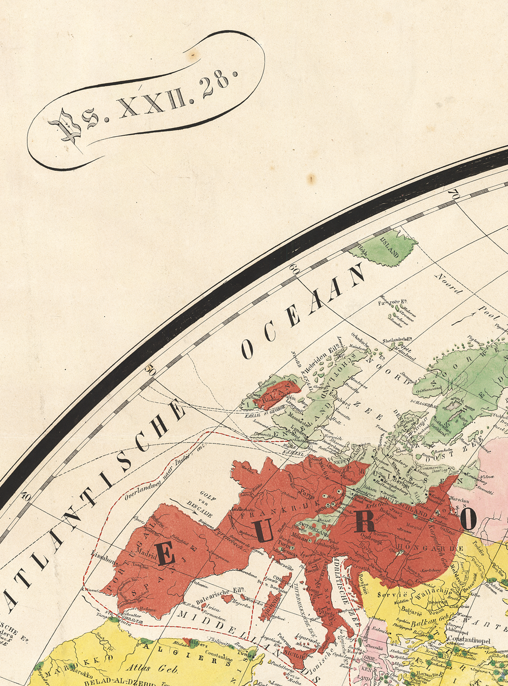
Groen's colour scheme is very much like Koetsveld's, although the colours are brighter: green (Protestantism), red (Catholicism), pink (Russian and Greek Orthodoxy), yellow (Islam), blue (Eastern Christianity) and black (heathendom). Black could be associated with racism, but we must keep in mind that other maps used white or scales of grey for heathendom, and Groen was a fierce opponent of slavery. In most missionary books, dark is associated with the absence of the light of the Gospel or indeed the slave trade.Footnote 76 Groen's choice of brown for ‘empty’ lands, such as the Sahara desert, is unusual. Like the Koetsveld map, the colour scheme suggests a more diverse global Christianity with no obvious focus on the Dutch colonies. Groen published a simplified world map in 1851 that has inset maps of West Africa, the Cape and India, but not of the Dutch East Indies.Footnote 77 The accompanying text of the larger map does not pay particular attention to the Dutch colonies, but Koppius in his review remarked: ‘With the Indian Archipelago the Dutch will be familiar.’Footnote 78 The map has two mottos, from Psalm xxii.28 (referring to the kingship of God) and Acts xiii.47, containing a command to spread the Gospel. Eight ethnographic images accompany the map, exotic figures such as an Inuit, a Native American, an Arab and an Indonesian native. Published almost simultaneously with the Koetsveld map, the Groen map tells a more complex story about world evangelisation with relatively little attention to the Dutch colonies.
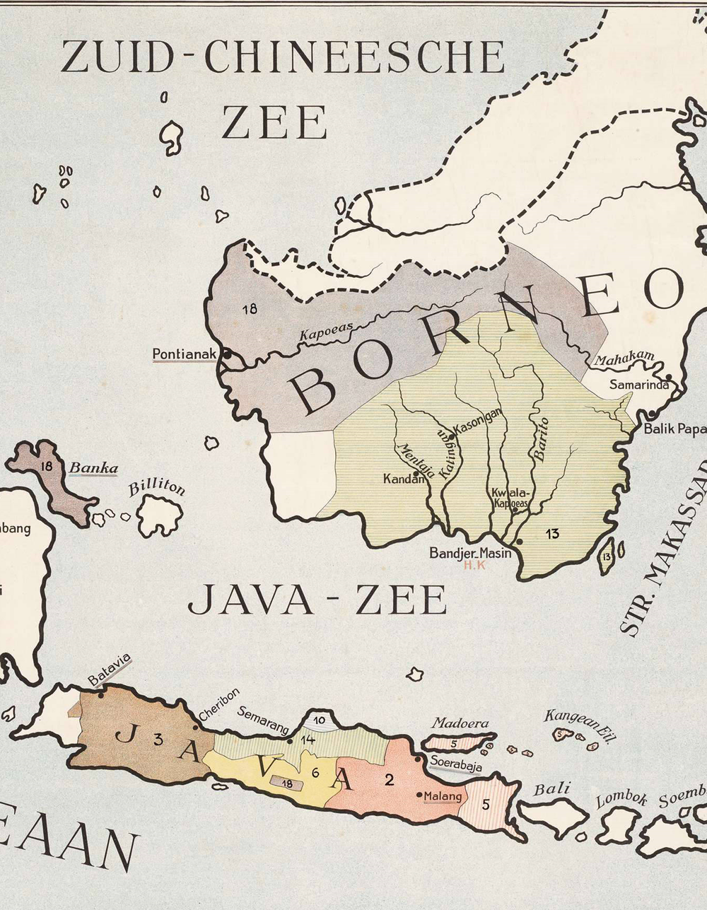
In the second half of the nineteenth century Dutch missionary cartography dried up and towards the end of the century preachers complained that there were no world maps of mission available in Dutch at all. It is testimony to the success and suitability of the Groen and Koetsveld maps, and of the international translated maps, but perhaps also of a shift in attention which the Nijland map, mentioned in the introduction, exemplifies. Evert Nijland's map, the Missionary map of the East and West Dutch Indies (see Figure E/3) was an extraordinary work of craftmanship due to its eye for detail and precision.Footnote 79 There were several versions. A large version (118 x 190 cm in four pieces) was published in 1891, followed by a cheaper and smaller (68 x 101 cm) one in 1894.Footnote 80 It enjoyed some reputation, because copies are still available at various Dutch university libraries, but also in Berlin, Yale, Paris and London. The map was available together with an explanatory booklet.Footnote 81
Evert Nijland, Zendingskaart van Oost- en West-Indië, Utrecht 1891 (section). This copy is held at the Department of Special Collections, Universiteit Utrecht, MAZ 155, and reproduced with their permission.

The map is entitled a missionary map and shows a variety of stations of various missionary societies. Its main feature is an overview of the Dutch East Indies archipelago, with smaller inset maps of the island of Java, the colonial capital Batavia and Surinam, the Dutch colony in South America. The maps are detailed and show the stations of various missionary societies, including those of the Moravian brothers, the German Rheinische Mission and even Catholic societies. Names of towns hosting either European missionaries or schools for ‘native assistants’ (‘inlandsche helpers’) are underscored. There is also a list of colonial administrative units, making this a fairly obvious example of the intertwining of empire and mission. Obvious too was the exclusive focus on Dutch colonial possessions: Dutch mission and Dutch empire overlapped.Footnote 82
The map showed the Indonesian archipelago as a Dutch possession. Coloured territories are part of the Dutch East Indies, whereas white areas are not; thus the colour schema of this missionary map is actually a colonial indicator. Colours are also used to indicate specific missionary societies that were active on the islands. Unlike in the mid-nineteenth century, other religions such as Islam are completely ignored on this map, and as such the colours underscore control and stability rather than the progress of Christianity. The selected frame of the map supports the view that this is really a colonial map: it cuts off sharply at the colonial borders, such as at New Guinea.Footnote 83 The map, moreover, is very neatly circumscribed so that the Dutch East Indies are in a vacuum; the viewer does not get a sense of where they are located nor is there any frame of reference pointing out that they are close to the mainland of South East Asia, nor to Australia. Only a very thin stretch of land on New Guinea shows that the eastern parts (then controlled by Britain and Germany) are not part of the colony. Dotted lines indicate oceanic routes of the Koninklijke Pakketvaart Maatschappij, the Dutch steamer company that serviced the archipelago. There are no sea routes indicated outside of the archipelago. In effect, the map presents the Dutch East Indies as a closed-off archipelago, well connected internally, and under Dutch administrative and infrastructural control.
The Nijland map marks a major shift in Dutch missionary cartography. Whereas the mid nineteenth-century world maps hinted at colonialism but also clung to the ideal of global mission, Nijland's 1891 map embodies an almost complete interplay between colonisation and mission. It synchronises with the Aceh War (1873–1904) which led to the consolidation of Dutch rule in Indonesia. It also marks the focus and direction of a multitude of Dutch missionary societies on Dutch colonies alone.
Because the detailed Nijland map was less suitable for schools, in 1911 a simpler map appeared entitled The East Indies, adjusted for mission (see Figure F).Footnote 84 This wall map, 101 x 119 cm, was produced by Luijtjen Kupérus, secretary to the (missionary) Java Committee and author of a children's book on mission.Footnote 85 The map has much in common with the Nijland map but is less complex and uses colour more proficiently. The map shows the Indonesian archipelago, with a very large inset map of Java (of obvious interest to Kupérus), several smaller islands and Batavia (but no West Indies colonies). Colours are used to distinguish the Dutch colony from other territories (in white), and to designate the activities of specific missionary societies. It is the first map that attributes full colour fields to missionary societies, and the homogenous colours negate the existence of alternative religions or beliefs. The colonial focus is obvious through the frame of the map, but also textually and symbolically indicated by listing the names of the residenties (colonial administrative units) divided by dotted lines. Like the Nijland map, the map does not have a missionary motto, illustrations or the obvious religious symbolism that was used in mid nineteenth-century maps. Arguably, Nijland's map was essentially a colonial map paying detailed attention to mission, whereas the Kupérus map rather focuses on mission within the obvious context of colonialism.
The Missionary map of the Dutch East Indies and Surinam (see Figure G/4) is in line with this development.Footnote 86 Annéus Marinus Brouwer (1875–1948) was a biblical scholar at Utrecht University and published his map in 1930. The map's design was significantly less complex than the Nijland and even Kupérus maps, with basic geographical references and dominated by coloured zones rather than underlined names, each representing the influence of missionary organisations. It included the stations of American and German missionaries, as well as references to Catholic influence. Like the Nijland and Kupérus maps, it limited itself to Dutch colonies of the East Indies and Surinam. Colours indicated the activities of missionary societies. The full colour reversal is stunning: whereas the mid nineteenth-century maps used grey or black for heathen territories to indicate spiritual darkness, the Brouwer map used white. Unlike in the Nijland and Kupérus maps there are no specific markers or symbols to indicate colonialism except for the dotted borders of the residenties.
Annéus Marinus Brouwer, Zendingskaart van Ned. Oost-Indië en Suriname, Groningen 1930 (section). This copy in held at the Universiteitsbibliotheek Vrije Universiteit Amsterdam, LL.03763gk, and reproduced with their permission.
Reviewing these six maps, several conclusions can be drawn about the propositions of Dutch missionary cartography. It is obvious that all of these maps have dual narratives, referring both to the extension of the kingdom of God as well as of the Dutch Empire. It is also clear that mid nineteenth-century maps were very different from later ones. What can be styled ‘first generation maps’ (c. 1845–55) were world maps, using biblical mottos and indicating the spread of Christianity but with increasing attention to internal diversity. Colonialism was either virtually ignored (Groen) or marginally referred to (Koetsveld and NZG) but not central in the visual narrative of the maps. The ‘second generation maps’ (c. 1890–1930) show a very different picture. World maps became unfashionable by the late nineteenth century and made way for more specialised maps of the Dutch East Indies. Here the entanglement between mission and colonialism was obvious. Some maps were missionary maps with a very strong focus on colonialism (Kupérus and Brouwer), but the Nijland map became quintessential for the symbiotic relation between these two. The Nijland map is the only map to use colour not to indicate religion but rather colonial territoriality. All other maps indicate that Christianity is expanding and ‘occupying’ territory, but whereas first generation missionary maps see mission stations as dots in a heathen landscape, second generation missionary maps are much more confident in claiming heathen lands for Christ. Another interesting feature is that earlier maps distinguish between religions, but later maps have a distinctly denominational character, listing different Churches or missionary societies. What later maps also have in common is that they ‘silence’ other religions. The focus on the Dutch East Indies as a frame for Dutch mission is understandable given the weight of that colony, but it would have been conceivable for Dutch missionary cartography to adapt a wider frame. For although the emphasis of Dutch mission was on the Dutch East Indies, there were also missionaries active in other parts of the world: Dutch Pentecostals worked in China (1910–24) and Congo (1914–18) through the Pentecostal Missionary Union, there were Dutch missionaries in Egypt between 1898 and 1955 and in Brazil, Peru and Argentina.Footnote 87
Use of Dutch missionary maps
Having established the propositions of Dutch missionary cartography, this section endeavours to gauge the social power of maps by analysing the ‘social assent’ given to these maps. This can be reconstructed by researching the ways in which these maps were used in public spaces and the manner in which the public responded to these maps. What follows is the harvest of an extensive search in primary sources, mainly missionary bulletins, book catalogues, newspapers and journals that are full-text available in the Delpher database system.Footnote 88 The focus of the analysis was on direct responses of audiences and reviewers to missionary maps, whether in lecture halls, Sunday schools or church meetings.
Before it can be established how maps were interpreted, it is important to know more about their material dimension, for maps are not just images but physical objects as well, having proportions and form and production costs. In order for a map to be effective, it must be available, affordable and suitable.
Availability was a sometimes a problem. In the early twentieth century, many teachers complained that they were not able to afford or find a suitable missionary map. A guide for teachers in 1900 complained that there was no Dutch missionary atlas or world map for mission available, since most maps were limited to the Dutch East Indies only. It referred to the German 1886 Grundemann missionary atlas for reference.Footnote 89 Indeed, the first Dutch missionary atlases seem to stem from the 1920s.Footnote 90 In line with the chronology of this article about first and second generation maps, world maps seemed increasingly difficult to find towards the late nineteenth century. One author in 1895 stated that he made use of a translated version of the German Grundemann Missionsweltkarte of 1862.Footnote 91 The Dutch increasingly relied on translations of missionary world maps, witness the missionary guide for preachers and teachers of 1900 that stated: ‘In Dutch there is no atlas or missionary map of the whole world which is up to date.’Footnote 92 According to the instructions of a weekly periodical for Christian education in 1911, teachers were required ‘to try to acquire a missionary map, either by buying one or drawing one himself’ on the blackboard. The 1911 Kupérus school map of the East Indies was recommended.Footnote 93 The Teachers Committee for Mission, concerned about the status of mission education in schools, issued a survey among 2,000 Christian schools in 1938, and received 750 replies. The survey revealed that only fifty-four schools were in possession of a missionary map (‘mostly the one by Prof. Brouwer’), and only five held a missionary atlas. Five schools were in possession of ‘Livingstone-plates’.Footnote 94
Affordability was also a concern. The Nijland map was popular but expensive: it sold for just under 8 guilders in 1895 and apparently for 13.50 in 1900, probably because by that time it was difficult to obtain a copy. The large version of the map was deemed suitable for schools, while the small version for study-room use cost only f 2.50 (or f 3.50 when attached to cotton).Footnote 95 The brightly coloured, purpose-made simple school map of the Dutch East and West Indies by Brouwer was advertised in 1935 for four guilders for a cheap version or ten for a large luxury one. The linen version for ten guilders featured wooden sticks and varnish, especially suitable for school classes. The size was 75 by 135 cm.Footnote 96 The smaller versions were specifically advertised for the study room, the larger ones for schools.Footnote 97 In 1892 the Revd G. A. van der Brugghen from Beets near Amsterdam bought his own world map to accompany his mission education for twenty guilders, and complained how expensive it was.Footnote 98
Suitability may have been the most difficult problem to solve. In 1854, the Revd Petrus Koppius believed that the Koetsveld map was suited for catechism and secondary schools.Footnote 99 Later generations complained about the complexity of certain maps. Van der Brugghen bought an ordinary world map in 1892 and complained that ‘it is unheard of that there is no large suitable missionary world map’.Footnote 100 The Dutch missionary yearbook of 1910 complained that although Nijland's map displayed excellent craftsmanship, it was too complex for a missionary school map.Footnote 101 For schools the problem remained until the Kupérus and Brouwer maps were published in 1911 and 1930. There was also a concern that teachers were not up to the task.Footnote 102 Even in 1938 one teacher complained about a ‘missionary map, which is far too complex, which needs voluminous textbooks that are difficult to use for preparation’. I need, he concluded, ‘an ordinary wall map’.Footnote 103 The simplified coloured map by Professor Brouwer was much more suitable for schools and was praised when it appeared in 1930: ‘There are many missionary maps being used at school, of course, but they are now dated, there is need for a newer map that gives an overview, and does so clearly.’Footnote 104
The usefulness of missionary cartography was widely acknowledged. In a 1939 survey about the knowledge of teenagers about mission, ‘several ministers pointed to the great importance of missionary maps’ for Sunday schools.Footnote 105 Teachers were receptive; as one anonymous teacher suggested, the importance of mission should not be impressed upon school children through an overdose of speech, but in a playful manner, with maps on the wall.Footnote 106 The use of missionary maps also required geographical knowledge. Van der Brugghen observed in 1892 that ‘Folk usually know the places in their immediate surroundings, with bridges, canals and roads, but of the earth's globe they have little knowledge.’ His concern was illustrated by one young man attending his lecture who believed ‘that I was to send him to the land of Canaan, when I actually spoke of Canada’.Footnote 107 A 1938 survey among Dutch school teachers evoked one response from a teacher who believed that missionary history should not be a separate subject, but a subdiscipline of ‘Christian geography’ as part of his geography lessons.Footnote 108 The intertwining of mission and geography was stressed in 1856 by the Petrus Koppius who underscored the importance of ‘missionary geography’ (‘zendings-geographie’): ‘Geography should be regarded as one of the most useful servants of Christendom. It can and must be a precursor to the Gospel, because it points to the places where a door is open to receive the servant of the Lord.’Footnote 109
Missionary geography was thus well established in The Netherlands, but what was its impact? In 1928, the Revd Mr Wildt reminisced about a German colleague who had a missionary map hanging on the wall above his desk. Every time he was in despair about indifference to and enmity towards the Gospel, he looked at the map and cried out loud: ‘and yet it marches on’.Footnote 110 The story resonates with an anecdote about William Carey, who reportedly, as a young minister, had ‘hanging up against the wall a very large map, consisting of several sheets of paper pasted together by himself, on which he had drawn, with a pen, a place for every nation in the known world … The substance of this was afterwards published in his Enquiry’.Footnote 111 The anecdote was referred to by a Dutch author in 1904, in a pamphlet on ‘The calling of the church’, speaking of ‘a shoemaker … who with his self-made missionary map in front of him … awoke the Christian world with a loud voice: “it is the will of God”’.Footnote 112 Whether apocryphal or historical, the story conveys a clear message about the role of a map as foundational for the emergence of the modern missionary movement.
This evocative power of the missionary map was widely recognised. One space in which the map was able to exert social power was the lecture hall. Missionaries and preachers travelled around to visit churches, youth clubs and societies and speak about mission. Large maps circulated for this purpose. The Groen map of 1854 was about 1.50 x 2.50 metres, whereas the Colton linen map of 1878 was a whopping 2.00 x 3.60 metres in size. The Revd Anthony Brummelkamp described a meeting in 1859 in the town of Ermelo in which the 1854 Groen map was on display. ‘After I left the stagecoach at half past 10 in the morning’, he met ‘the friends who had assembled to labour for the gentiles – in prayer’. They then crowded around the missionary map to listen to a lecture.Footnote 113 The theologian Philip Hoedemaker described a Sunday evening meeting of a youth society in 1875. ‘A bowl of coffee is poured and biscuits are presented – you are free to bring your own pipe.’ A missionary tells a story, and after the lecture two missionary maps are shown, ‘an English and a Dutch one … They are so attractive that the audience yearns for an explanation’.Footnote 114 The description makes it clear that the maps were the English and Dutch versions of Gilbert's 1861 Pictorial missonary map. Half a century later, the practice of using maps for lectures was still current, witness a report from 1927. The Revd Mr Scharten gave a public lecture in an orphanage in Nijmegen, ‘by using a large missionary wall map of the missionary work of the Moravian brothers’. He did it in such a way ‘that we all were imbued with a sense of our Christian duty to support the missionary effort as much as possible’.Footnote 115
Another context in which missionary maps played an important role was the classroom of schools and Sunday schools. Missionary maps were useful for instructing adults, but children were particularly addressed. Dutch school maps for wall display appeared first around 1820 but really took off in the 1840s. The first map of the Indies was probably published in 1843.Footnote 116 They were soon recognised as a useful tool for teaching, if appropriate for the age group. Missionary school maps seem to have become a regular feature by the late nineteenth century: witness the testimony of the Revd Lodewijk Schuller tot Peursum, who reminisced about his youth in the 1860s, and remembered ‘watching the missionary map with dark coloured heathen lands, hanging in the Sunday school room on the Kromme Nieuwegracht’ in Utrecht.Footnote 117 There is some tension between this statement and Bernard Porter's suggestion that coloured classroom maps of the British Empire were rare before the 1880s.Footnote 118
The evocative power of missionary maps increased by using them in conjunction with other media, for instance in fiction. Authors like Adolf Hoogenbirk and Aletta Hoogh were prolific writers of children's books that are now all but forgotten, but were widely read in the late nineteenth and early twentieth centuries in The Netherlands. In 1916 Hoogenbirk, an avid student of foreign languages and cultures, published The way of the Lord, a short story. The story opens with the main character, a young boy, Frederik, entering a bookstore and noticing a strange map of the world that did not so much point to cities or states, but was coloured in patterns unfamiliar to him. The seller, ‘a God-fearing man’, was ‘eager to speak of such things’, and explained that sky blue (in Dutch: hemelsblauw: heavenly blue) stood for Protestant territories, red for Catholic, yellow for ‘Mahometan’ and black for heathendom. ‘Do you think, sir, you will live to see the whole world sky blue?’, Frederik asked. Back home he expressed a strong desire to his mother to become a missionary and convert the heathen. Growing up, Frederik became a school teacher in an insignificant rural village, frustrated by his inability to become a missionary in far-off regions. But one day he received a letter from one of his former pupils, who turned out to have become a missionary on New Guinea, inspired by the godly teaching of Frederik.Footnote 119 Luijten Kupérus, as well, wrote a short story for children, He who seeks will find – a missionary story, published by the Dutch Sunday School Society in 1901. The story is set in India and opens with a description of the subcontinent, its features, its culture and its religion. Illustrations of a missionary with a map and of Indian gods accompany the story, that ends with the missionary map of India.Footnote 120 In both stories, the missionary map was the visual trigger for missionary activity.
A fascinating lens of the performative power of maps is their usage in combination with spiritual activities, most notably song and prayer. Daniel Crosby's 1827 map lecture in Boston, for instance, was accompanied by ‘three prayers’ and ‘singing’.Footnote 121 In an instruction for Dutch Christian teachers of 1911, they were advised to teach the children several Psalms and hymns that help ‘develop the missionary ideal. In his prayer and thanksgiving he can express our call for mission’. The instruction then moves on with advice on suitable missionary maps.Footnote 122 The Revd Anthony Brummelkamp, in his 1859 meeting in the town of Ermelo, stated: ‘The large missionary map of G. Groen was on the wall. We sang, we read a word in Scripture and laid ourselves down for the Lord in prayer.’Footnote 123 Van der Brugghen, who described a meeting for which he used a missionary map, lamented that he was not in possession of an organ, ‘for I am unable myself to lead the congregation in singing’.Footnote 124 Another speaker in 1850 elaborated on the use of the ‘visual presentations of the missionary labour by the well known missionary map … more than once the existing choir company came to my aid’.Footnote 125 Philip Hoedemaker, in his description of his meeting in 1875, during which the Pictorial missionary map was shown, reported that the meeting started with song, followed by prayer, and then by the lecture on the map. For J. J. van Oosterzee the very act of singing itself was territorial: hymns filled the ‘deadly silence’ of the ‘endless forests of Mississippi and Missouri’.Footnote 126
Prayer in particular was not only deemed effective; it was also able to transport one to the very places one saw on the map. Brummelkamp described a lecture on mission accompanied by the missionary map. ‘In prayer we accompanied the teacher to Java, Sumatra, Africa.’Footnote 127 Praying in front of a missionary map made one an actual participant in the missionary enterprise. The song Hoedemaker mentioned was highly appropriate for the occasion: ‘All the pagans, brought forth by your hands in all the lands, will come to you Lord.’Footnote 128 The missionary map thus became the visual focus for the singing, inspiring the believers to participate in the missionary effort. Song was not just ‘festive’, as the 1850 speaker observed, but also ‘added more glory … to the occasion’.Footnote 129 Indeed, song had performative power; the singers marched towards victory in a war that the map visualised. Prayer was even more powerful. The youths attending Hoedemaker's meeting had all set themselves to prayer in the morning.Footnote 130 Anyone who looks at this world missionary map, Groen stated in the guidebook accompanying his 1854 map, ‘should feel incited to pray and support’.Footnote 131
The social power of maps was thus such that they were able to educate, inspire, galvanise and even transport the onlooker to the very territories on the map. But to what purpose? What seems striking is that earlier generations had a much more global vision of mission. J. J. van Oosterzee, in his 1855 annual lecture for the Nederlandsch Zendelings Genootschap, painted a worldwide image of mission, ranging from Greenland in the ‘nebulous North’ to South America, from Celebes to India and the ‘islands of the South Sea and Australia’. Java and Libya are mentioned in one sentence.Footnote 132 In 1859, Brummelkamp described a lecture in which ‘Java, Sumatra, Africa’ are conflated in a single context.Footnote 133 In later eras this global paradigm shifted. One anonymous teacher in 1938 stated: ‘I have a need for a method for my geography lessons about the Dutch Indies, in which missionary material can be used.’Footnote 134
There was always a territorial dimension to mission. One American pastor in 1842 stated that the map was an important vehicle of education for those ‘interested in the political aspects of the nations’, to make them understand ‘our views of the great fact that this world belongs to Christ’.Footnote 135 In 1850 Johannes Sonstral, a Lutheran minister in Den Helder, reflected upon the General map of Christian missionary stations: we will send
our armed forces to alien regions, without hesitation … for our King has been given all power in heaven and upon earth. We will clasp each other's hands. We will conquer Java, not to oppress them as slaves, but with the blessing of freedom, equality and fraternity … the Lord will be with us and hand us over the land.Footnote 136
The primary purpose of mission was conversion in order to establish the Kingdom of God. But the spiritual battle took place in the real world. Just like ‘the walls of Jericho … collapsed through the trumpet sound of faith’, so heathen lands were conquered.Footnote 137 The reference to Java was telling in the light of the fairly recent Java War (1825–30) and continuous unrest during the remainder of the nineteenth century. In a similar vein, Koppius argued that the English colony of Aden ‘should earn its place’ on missionary maps, even if it held no missionary post.Footnote 138
It is in Nijland's map that the conflation of imperial territory and mission is almost complete.Footnote 139 Indeed, the Dutch missionary yearbook of 1910 praised Nijland's meticulous map, ‘for which he received the support of both the government and the Committee of the Dutch missionary conferences’. According to the author, Nijland was right to consider the map of ‘general Dutch interest’, and he lamented the fact that Nijland had been unsuccessful in tirelessly soliciting the Dutch government to adopt and rework the map to become ‘the schoolmap of the Indies’.Footnote 140 This desire was also expressed in the Teachers Missionary Committee of 1938:
Our pupils will learn more about our colonies precisely as a result of the interest raised by missionary education. The people at large have no apparent direct interest in our overseas possessions and care as much for the [Dutch] East and West Indies as for Japan. If, however, missionary education will spark concern for our colonies, there is a chance it will be enduring.Footnote 141
Although it is true that Dutch missionaries operated within the confines of the Dutch Empire and experienced its gravitational pull, they were also deeply aware that theirs was a kingdom that was spiritual rather than political. The missionary map will be cleared of white spots, Ms Cremer wrote in an eschatological column in 1939. ‘The hour will certainly come, for we have a Saviour, who proceeds along the roads as a victorious King with conquering glory.’Footnote 142 Philip Hoedemaker in a 1903 sermon warned precisely about the conflation of mission and empire, and partly blamed the missionary map for instilling this connection. ‘We colour our missionary maps black where the Church of Christ has not yet been established, and in this way we say that the realm of darkness exerts unlimited power here. There is undoubtedly an element of truth in this. But Scripture has a different point of view and teaches us a more humble truth.’ Satan is present everywhere there is sin.Footnote 143 To Hoedemaker, the Dutch missionary map, precisely because of its tendency to merge with the map of the empire, did not adequately represent the true purpose of mission.
The period between about 1850 and 1940 saw the ascendancy of the missionary map in the missionary movements of Protestant countries like Britain, Germany, the United States and The Netherlands. The map became a regular ingredient in the efforts of missionaries, teachers and preachers to convey information about mission and to galvanise adherents to support the cause. Despite the ubiquitous presence of missionary maps, sustained historical research remains sparse. This article functions as a pilot study to investigate the range of maps available, to understand their narratives and analyse how they were used. The social power of maps in The Netherlands between about 1850 and 1940 was such that they educated children and adults about the missionary enterprise and inspired them to support or even join the cause. Maps were used in classrooms, Sunday schools and lecture halls, and seemed to have been effective in capturing and directing the imagination of the audience, especially combined with song and prayer. They exerted an extraordinary power to visualise and connect with the missionary effort. Whereas explicit references to the intertwining of colonial possessions and missionary purpose were relatively rare, the context of Dutch mission within the colonies and the focus of many Dutch missionary maps on the Dutch East Indies made that connection not just obvious but also tangible by visualising it. Indeed, it is precisely for this reason that at least one minister complained that missionary maps diverted the attention of the spectator from the real purpose of mission, conversion. The article has validated and illustrated Remco Raben's view that missionaries increased an awareness of the empire among Dutch people.
This ‘awareness’, however, needs some qualification, for missionaries did not set out to establish empire but to evangelise the world. In what were styled ‘first generation maps’ (around 1850), Dutch missionary cartographers visualised global mission as a joint Protestant effort, with reference to but no emphasis on Dutch colonialism. ‘Second generation maps’ (1890–1930) show a very different picture. Whereas some maps paid primary attention to mission, others were essentially colonial maps, and none really escaped the colonial paradigm. This neatly fits the chronological view of Wim van den Doel, who suggested that the relationship between mission and empire was loose or even antagonistic in the early nineteenth century, but tightened towards the end of that century. There was marginal criticism of the territoriality of Dutch missionary cartography, but the majority of mission supporters favoured the conflation of mission and empire. For Nijland colonialism and mission were symbiotic, but for others the Dutch colonies happened to be the place where mission was taking place, whereas for early generation missionary cartographers the whole globe was the playing field of mission. Even so, the increasing concentration on the Dutch colonies certainly provided an optic image in which the progress of mission aligned with the territoriality of empire. The purpose of the missionaries was global conversion and the establishment of the kingdom of God and not the empire, but in Dutch missionary cartography the two became increasingly entangled.
This article has also validated the conclusions of Alec Ryrie and David Trim that the purpose of mission aligned with empire but was not necessarily similar. This historicised and dynamic perspective is important because it prevents the historian from drawing essentialising conclusions about the connection between mission and empire, and also raises questions about the nature of missionary cartography in the postcolonial period.Footnote 144


 Open access