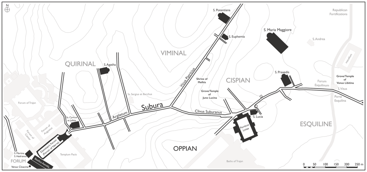
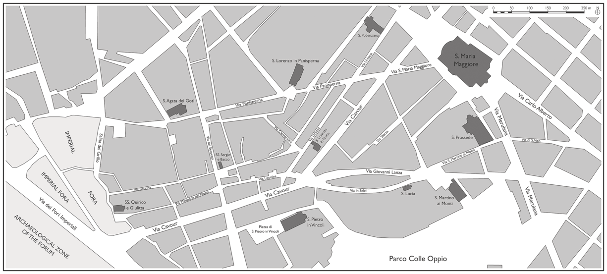
On January 9, 2013, Cesare Esposito was not happy. The sixty-five-year-old artist, a longtime resident of Rome’s Monti district, had just been evicted from his residence. The heart of Monti essentially covers Rome’s eastern hills (Quirinal, Viminal, Cispian, Esquiline, and Oppian) and the valleys formed between them as the landscape stretches downhill and westward toward the ancient Forum (Plate 0.1; Map 0.1). Esposito’s family had lived here for generations, and he had thrived in the neighborhood that had been one of the areas of Rome most associated with artists and artisans of all sorts for centuries. But Esposito’s connection to Monti has meaning beyond his family history there. He is the artist in charge of one of the highest-profile ceremonies in Monti’s annual calendar: the celebration of the Miracle of Madonna della Neve at the papal basilica of S. Maria Maggiore, which looms over the central part of Monti from the top of the Cispian hill. Every year on August 4, the ceremony recalled the miraculous snowfall that occurred on that same date in 352 CE, when a rich patrician was directed by the Virgin Mary in his dream to construct a basilica where fresh snow had fallen that morning. The bishop Liberius, upon being informed of this dream, said that he had had the same one, so he marked out a floor plan for the basilica on the ground of the Cispian where snow – somehow in the heat of the late summer – had indeed fallen. Esposito directs the annual reenactment of this snowfall, which entails blasting artificial snowflakes from the roof of the basilica, and he has devoted his artistic efforts from time to time to numerous other church or civic celebrations across the city for decades. But now, Esposito said, he sleeps in the archaeological ruins of the ancient imperial fora that enclosed the lowest part of Monti, forced to look upon Monti and his former residence from the street. Esposito had been fighting the city to keep his apartment and studio since 2006, but he had now suffered the final defeat. Only by selling all of his belongings could he afford to get it back.Footnote 1
The modern neighborhood of Monti, corresponding to the ancient Subura valley.
Esposito is apparently not the only person who has thought to sleep amid the ruins of the imperial fora. In October 2014, the art magazine Artribune reported on a displaced person who had set up a makeshift shelter within the ruins of the Porticus Absidata and Forum of Nerva, mere yards from the apartment from which Esposito had been evicted the year before. A reader disgusted by the alleged inaction and incompetence of the Soprintendenza, which was meant to protect Rome’s cultural heritage from such violations, had tipped the magazine off.Footnote 2 This incident and Esposito’s case are only two small parts of a process of both social and physical transformation in contemporary Rome in which the government has been unable to manage the consequences of its own policies. Monti, with its historically working-class residency, has felt the impact especially hard: gentrification; rising real estate values; the shuttering of small businesses; and the displacement of families and individuals who have been economically, socially, and culturally invested in the neighborhood community by tourists or part-time residents from outside Rome who are less so.
Monti was, and still is, changing below Esposito’s very feet. It is change one can feel on a day-to-day level. But the artist also appreciates that the processes by which his neighborhood was turning upside down ran much deeper, with driving factors that extended well beyond his corner of Monti. In his 2009 work Evicted from Eternity: The Restructuring of Modern Rome, anthropologist Michael Herzfeld painstakingly documented this change, which has been underway at least since the last quarter of the twentieth century.Footnote 3 Much of what Herzfeld traced is the impact of institutional policies – municipal, national, and ecclesiastical – on local, neighborhood dynamics. How well can once-tight social bonds and loyalty to the locale withstand the changes that political institutionalization and, moreover, cultural and economic globalization have brought? Not very, it turns out. Modern Monti is a clash of old and new, memories and modernizations, a sort of war of values in which locally oriented residents fight against the interests of those who have less personal attachment to the area but are keen to capitalize on the memories of “old Rome” that it offers. Traditional neighborhood bonds formed across centuries of community organization dissolve amid new forms of municipal civic engagement and a new economic system that displaces the highly diverse types of independent artisans who have inhabited the neighborhood for millennia. And the neighborhood’s new investors – municipal and state government, the Church, real estate dealers – have built a new physical landscape that has preserved the old urban fabric in some places but destroyed it in others. With that destruction naturally comes the loss of visual and spatial social memory, which is encoded into any physical space. The transformation of Monti is insidious, the result of multiple processes at work both externally and internally, and the impact has been felt in nearly every aspect of life there.Footnote 4
Herzfeld’s study essentially elucidates top-down and bottom-up (or generative) processes of urbanism, those driven by institutions and their actors on the one hand and popular agency – either deliberate or unintentional – on the other. Top-down processes have preoccupied urbanists, especially historical ones, for centuries. Studies on aspects of state-sponsored monumentalization, infrastructural development, and religious and economic spaces vastly outnumber those of, for example, neighborhoods or private economic or religious activity. The imbalance has misrepresented how urban change works, as urban development and transformation are in reality products of both top-down and bottom-up factors.Footnote 5 At any given time, both processes are at work, even if one prevails over the other. Haussmann’s Paris ca. 1860 is a famous example of top-down urbanism, whereas generative urbanism can be seen in the very winding medieval streets and warrens that Haussmann sought to eliminate. Nineteenth-century Paris is an admittedly extreme example, but Rome and Monti experienced much the same not too long afterwards during the area’s redevelopment as Roma capitale in the final decades of the same century.Footnote 6 Most cities experience developmental pull from both directions, and the balance between them is in constant flux.
Monti’s recent dynamism could certainly be seen as a radical rupture with its past, but the present changes are really only one phase in a long history of development and transformation in this neighborhood of Rome. In this sense, Monti’s continued adaptation within the contexts of much broader societal change attests to its health as a vital urban district. Cities and their constituent spaces are more than just collections of monuments surrounded by static space and a passive population navigating between them. They are, rather, social products constantly undergoing (re)generation and change. The city’s image is never fixed. Many critical theorists and urban sociologists have argued that urban dwellers have great agency in determining the shape of the city around them, but the shape of the city, as made by both its natural and artificial landscapes, also transforms popular and institutional behaviors in turn.Footnote 7 The relationships that develop recursively between a city and the humans that occupy it are therefore the very drivers of both urban and social transformation, and they necessarily include both institutional and socially contrived spaces in this cycle of urban development. Such ideas accord nicely with Anthony Gidden’s theory of structuration that posits a continual relationship between institutional power-holders and individual agents that is mutually constitutive and embedded in a spatial context that is itself changing as a result of societal change.Footnote 8
Taking cues from Monti’s transformations of both space and society and the dynamic relationship between top-down and bottom-up developmental forces that they entail, this book presents an urban history and archaeology of the ancient Monti, the area of ancient Rome known as the Subura. It encompasses nearly the first two millennia of the area’s occupation and development, ca. 850 BCE to 850 CE, from the Iron Age to the Early Middle Ages. The ancient Subura probably resembled pregentrification and preindustrialization Monti fairly well: a mostly, though not exclusively, lower-class region dominated by small-scale commercial and productive activity with some sprawling elite houses amid a sea of low-value housing stock. Unlike in the case of modern Monti, one cannot write an ethnography of social and cultural change in the historical Subura for reasons that are more or less obvious, but it is hoped that by studying a combination of physical, social, and cultural evidence over the longue durée, we can see the co-constitutive relationship between large-scale social change and the transformation of physical urban space (i.e. how the meaning of the Subura’s landscape on both the micro and macro scales was redefined and valued through time).Footnote 9
Top-down processes have been well-covered in archaeological studies of ancient Rome. Not only were institutional structures such as civic monuments and temples the most well-built and therefore the most enduring in the archaeological record, but archaeological studies themselves have historically developed in tandem with disciplines such as ancient history and topography that tend to focus on institutional history. What is more, archaeological activity in Rome has so often originated from modern political regimes and been intended to serve ideological purposes that were at odds with or even undermined by bottom-up, organic urban development. Much evidence for the physical city up until the last quarter of the twentieth century resulted from large-scale excavations that were themselves significant moments of top-down urban transformation: Vatican excavations in the eighteenth and nineteenth centuries, Napoleonic projects in the Forum and imperial fora in the early nineteenth century, the massive urban redevelopment associated with the construction of Roma capitale later that same century, and Mussolini’s imperialist projects throughout the city in the early twentieth century. Archaeology in pre-1980 Rome was for the most part politically contingent. The monumental fabric emerged from these excavations because of the political and ideological meanings it bore for each government at the time.
The 1980s, however, saw a picture of a more mundane ancient Rome emerge with the rise of post-processualist approaches. Work at the Crypta Balbi in particular caused a phase shift in the archaeological mindset of the subsequent generation, and much more attention is now being paid to the everyday city and its own processes of change apart from the monumental fabric.Footnote 10 The Crypta Balbi excavations also advocated a more diachronic archaeological perspective that not only includes but also extends beyond the period of Rome’s imperial apogee. Many subsequent excavations, such as those at the imperial fora, have followed suit.Footnote 11 This work has led to greater interest in Rome’s transformation over time, and numerous studies of the protracted lives of various monuments or discrete areas have been produced over the course of the last two decades.Footnote 12 Indeed, the entire history of Rome as a city from Late Antiquity through the medieval period has recently been revisited since R. Krautheimer’s study of the period in 1980.Footnote 13 These contributions have importantly fleshed out generative processes of transformation that took place in pockets of ancient Rome’s landscape, and they have shed critical light on how the monumental and the residential fabrics related in certain locations of the historical city.
This study of the Subura combines the interest in Rome’s longue durée archaeology that these previous studies have embraced and an interest in the dynamic relationship between generative and institutional urban development that is still playing out in Monti today. The situation in the ancient Subura was complex, and the neighborhood lends itself to a nuanced understanding of how cities transform and how the relationship between different types of structures and spaces can shift. Over nearly two millennia, the relationship between bottom-up and top-down development transformed over and over again, at times radically, depending on the overarching political and cultural context. If institutional agency prevailed in one period (e.g. the early empire or the early medieval period), popular agency predominated in another (e.g. the Republic or Late Antiquity). Sometimes the two processes operated harmoniously; at other times they undermined each other. The Subura’s ancient urban development complicates often linear narratives of historical urban transformation, reveals broader social agencies in this transformation, and shows how different aspects of urban development inevitably affect others in turn.
Defining the Subura
What was the Subura, exactly? The extents of the area have actually been disputed since antiquity. Varro named a regio Suburana as one of the four original regions of the city, and he applied it to an area covering the Caelian hill, the Colosseum valley, the Carinae, and the extended valley between the Argiletum and the Esquiline hill.Footnote 14 The Subura proper, however – the area that gave its name to the larger regio Suburana – occupied only this last area.Footnote 15 In general, the Subura stretched from the Argiletum, in the area where the imperial fora later rose, to the foot of the Cispian hill, then it ran up the valley between the Cispian and Oppian hills along the Clivus Suburanus (Via in Selci) and further to the head of the valley around the modern Piazza S. Martino ai Monti (Map 0.2).Footnote 16 Whether the toponym Subura extended farther east, all the way to the Porta Esquilina and the Servian wall, is debated depending on how the extension of the Clivus Suburanus in this area is understood to have been called, but the ultimate lack of any evidence for the nomenclature of this area leaves the question unresolvable.Footnote 17
The terrain and primary thoroughfares of the Subura.
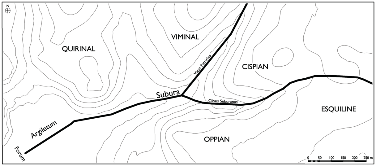
Our sources indicate that the valley was sometimes mentally divided along its length. Martial and Juvenal both mention a Subura prima and a Subura media, while an inscription mentions a Subura maior, implying the existence also of a Subura minor.Footnote 18 Topographers have puzzled over these divisions for centuries, but current consensus identifies Subura prima as the lower Subura, adjacent to the Argiletum, while Subura media was the area centered on the junction of the Clivus Suburanus and the Vicus Patricius (Via Urbana). In the epigraphic evidence, Subura maior is taken to mean the lower, more commercial half of the valley, while the assumed Subura minor would have referred to the upper half.Footnote 19 The boundary between the Subura prima/maior and the quarter of the Argiletum has been debated, but it is generally located at the eastern limits of the imperial fora.Footnote 20 In reality, these divisions would have been abstract – ever shifting, difficult to pin down, and varying according to individual perceptions. Such is typically the case for most neighborhoods or districts, where boundaries shift based on what events unfold within them and the changing mental understanding of its own residents.Footnote 21 Indeed, over time, the area included within the extents of Subura widened when surrounding areas lost their original points of topographical reference and the city’s early medieval urban fabric thinned out. Like most neighborhoods, the Subura was therefore somewhat amorphous, especially in the longue durée, but it is nonetheless clear that the entire valley was conceived of as a single geographical and topographical unit. For the sake of clarity, I use “lower Subura valley” to indicate the Argiletum, lower Subura, Quirinal and Oppian slopes, and the central Subura and “upper Subura valley” for the upper Subura and the southern Viminal and Cispian hills, but it is important to conceptualize the entire valley as a whole, where developments in one area had effects on the others.
Doing so has implications for understanding how the Subura functioned beyond its nomenclature. The shape of its terrain as a compressed valley running downhill into the forum drove movement that connected all of the Subura’s parts. Unlike the city’s hilltops, no part of the Subura could function in isolation, as each one constantly saw people and goods moving through it. This movement had a tremendous effect on the Subura’s development, driving the commercial development that dominates our impression of the area from both the literary and epigraphic sources. The Subura was by nature prescribed by the kinds of raucous activity associated with this commercial activity: the loud shopkeepers and customers, noisy workers doing dirty work, barking dogs, and prostitutes. The valley, which functioned as a discrete and cohesive topographical unit, was therefore fundamental to the Subura’s development beyond the physical aspects of movement and space; the very nature of the district – its economic, social, and ideological characters – was conditioned by it.
Given the Subura’s natural connectivity, it became clear early on that the Cispian hill and the valley between it and the Viminal hill that was lined by the Vicus Patricius (the modern Via Urbana) also needed to be included in this study. The Cispian hill, commonly overshadowed by the city’s other promontories, was actually the highest point within intramural Rome, and it loomed over the lower Subura valley. As such, it featured prominently in a system of meaning created and modified by both institutional and neighborhood actors over the period of examination. What happened in the Subura was very much determined by what happened on the Cispian, as the two zones were intimately connected by important urban paths. The Vicus Patricius was also just as much a natural feeder to the lower Subura as the Clivus Suburanus. It topographically mirrored the Clivus Suburanus, likewise encouraged east–west movement, and significantly contributed to the character and meaning of the entire Subura valley. The fortunes of the two valleys usually mirrored each other, but periods in which they diverged are instructive for the dynamics of the area as a whole. The major thoroughfares of the Argiletum, Clivus Suburanus, and Vicus Patricius were the primary paths of movement between the Forum and the eastern extents of the city. They directly linked the eastern hills with the functional and symbolic heart of Rome, and everyday operations in the city depended on continuous movement along them from top to bottom. The unity of the valley and this movement require that we respect its physical integrity and treat each part as connected in order to fully consider how occupational or physical changes in one part of the valley impacted areas in the rest of it.
Evidence
The Subura is not an easy area of ancient Rome to study. The evidence, whether textual or material, can be problematic and difficult to work with. First, there is the weight of its own reputation. The actual number of references and sources we have for the Subura is quite small. It is named only twenty-nine times, excluding lists of regions, and most of these mentions are brief and inconsequential. The remainder are descriptions from poets – namely, Martial, Juvenal, and Propertius – who dwell on the area’s reputation for noise, crowds, and prostitutes. For them, no area of ancient Rome evoked the everyday sights, sounds, and smells of the city more than the Subura. It was dismal and seething, with barking dogs, noisy butchers, and shoddy buildings prone to fire or collapse. Its narrow, crowded streets lined with small shops were wet and dark, thronged with indigents, petty crooks, and prostitutes. It was a miserable place, home to the “thousand dangers of the savage city,” as Juvenal put it.Footnote 22 This impression from the ancient literary sources is remarkably consistent, and the descriptions are so vivid that the neighborhood has come to define the “other side” of Rome in both the popular and scholarly imagination.Footnote 23 These portrayals may speak to the Subura of the high imperial period – if we can put any faith in them at all – but they have overshadowed any knowledge we may have of the place from both different time periods and different types of evidence. A combination of archaeological and textual evidence, for example, shows that the Subura was a rather posh residential area already during the Republic, if not even earlier, and a similar picture has emerged from mostly archaeological evidence for the later periods as well. Clearly the picture was more complicated than the literary sources suggest, even in the period to which our poets belonged.
But the archaeological evidence is not unimpeachable either. The eastern and western extremes (i.e. the Esquiline and the Argiletum/Imperial fora) have witnessed extensive clearance excavation that has destroyed large quantities of archaeological evidence with very little documentation. At the eastern end, the Esquiline and Cispian hills were occupied mostly by a series of expansive urban villas since the early modern period, but after Rome became the capital city of a newly unified Italy in 1871, these were uprooted, and the surrounding landscape was subjected to massive clearance excavations carried out as part of a large-scale campaign of urban development.Footnote 24 With this came the razing of large swaths of Monti to expand roads and reroute traffic to ease movement between the center and the Esquiline.Footnote 25 This period could be seen as an extreme example of the tension between governmental and popular interests that the Subura and Rome at large have experienced over its history. During the demolition, archaeological finds were frequent, but they often received only cursory study or publication, as the newly formed archaeological commissions and bureaus were understaffed and overwhelmed by the quantity of the material.Footnote 26 Moreover, since most of the structures found were domus or shops, they rarely received the kind of detailed analysis that was reserved for larger civic monuments. The finds were usually briefly reported in the Notizie degli Scavi upon their discovery, while the most notable and sizable ones were also included on R. Lanciani’s Forma Urbis Romae (hereafter FUR), a map that combined the nineteenth-century plan of the city, the anticipated additions or changes to the urban fabric to accommodate an expanded bureaucracy, and archaeological finds made during demolition for the new buildings.Footnote 27
In the lowest part of the Subura valley, the Forum of Nerva and subsequent development in it were similarly excavated under the hurried conditions of large-scale urbanization. In the 1920s and 1930s, Mussolini razed most of the medieval and modern structures and streets here for the construction of the via dell’Impero (now via dei Fori Imperiali).Footnote 28 As a project ideologically linked to the buildings of Rome’s emperors, these clearance excavations aimed simply to expose monuments built by ancient emperors, from whom Mussolini and his Fascist colleagues drew such great inspiration. The very act of eliminating part of the Subura’s workaday urban fabric for the sake of constructing (or, in this case, revealing) an ideologically charged imperial monument harkened back to the activity of Augustus and other emperors here some two millennia prior.Footnote 29 Very little of the removed archaeological material, especially that from Late Antique and medieval levels, was published.Footnote 30 Only in the late twentieth century did academic archaeologists become much more interested in trying to reconstruct the lost data and in documenting and interpreting in careful detail the stratigraphy of the fora, especially the pre- and post-imperial periods, through new excavations.Footnote 31
In the heart of the Subura between the Argiletum and Esquiline, much of the ancient fabric has been destroyed or concealed not by redevelopment programs, but by the two millennia of continuous occupation that the zone has enjoyed. Rescue excavations or chance finds made during the construction of or repairs to buildings, plumbing, or gas lines therefore predominate in the evidence. Each find is documented to a different extent, if at all, and that documentation is scattered across a number of archives in the city. Very few scholarly excavations have taken place here. An invaluable resource both for this area and for the valley as a whole is therefore the now publicly accessible SITAR database and Geographic Information System (GIS; Sistema Informativo Territoriale Archeologico di Roma: www.archeositarproject.it/en). This project collects every piece of archaeological evidence for the city and presents documentation and bibliography for each site that the project has so far recorded. Complementing this database is a recent doctoral thesis from La Sapienza University of Rome that collected the archival records for all known archaeological finds on the Cispian, which date mostly to the late nineteenth century.Footnote 32 Unfortunately, most of the archaeological material is undatable or its function is unknown, but at least some of the buildings can be ascribed to a certain period.
If zones of continuous occupation can be problematic for the survival of ancient structures in Rome, the opposite tends to be true for the sites of churches within the city, since these often preserve pre-Christian Roman structures that have been interpreted as relevant and significant to the church above them. The Subura is fortunate to have many churches within its confines. These structures have traditionally been the domain of early Christian archaeologists, who applied an admirable level of archaeological scrutiny during the first half of the twentieth century, but whose interpretation of the remains was typically heavily influenced by hagiographical tradition. Since the mid-twentieth century, however, more Roman archaeologists have worked on early Christian sites, while early Christian archaeologists have become much more critical and dubious of later textual sources.Footnote 33 As the study of Late Antiquity has emerged as a field unto itself, a much clearer and more robust dialogue between Christian and Roman scholars has benefited the study of Rome – especially the Subura – tremendously.
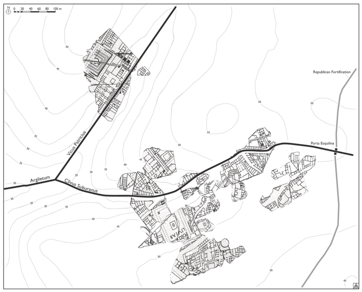
Epigraphic evidence for the Subura is not voluminous by any means, but what we have provides historical detail that is otherwise absent from the archaeological record, especially the names of building owners or patrons of certain shrines that are otherwise unattested. Stamped fistulae are particularly abundant in the imperial period, attesting to a large number of property holders even when the structures of the actual properties themselves are absent. Fistulae require due caution, however, since many were stamped several times along the length of the pipe leading from the main water source to the house – a distance that may have exceeded a kilometer – so the location of the stamp can only suggest the proximity of the property, not give an exact location.Footnote 34 Perhaps most valuable, are the preserved fragments of the third-century FUR, the colossal marble plan of the city installed in the Templum Pacis during the Severan period.Footnote 35 The systematic publication of all known fragments in 1961 and the ongoing efforts to match fragments have not only allowed more of the city’s monuments to be identified but also revealed the configuration of the city’s non-monumental streets and neighborhoods. The essential features of the Roman townscape that are unattested or poorly attested through archaeology in Rome, such as tabernae, small local bath complexes, and headquarters for collegia, have all been identified on various fragments.Footnote 36 The Stanford Digital Forma Urbis Romae Project, which has digitized and analyzed all extant fragments of the plan, is indispensable for its study.Footnote 37 By sheer luck, a large section of the Clivus Suburanus, southern Cispian, and Vicus Patricius has been identified on extant fragments of the FUR, thus providing insights into at least the form of the streets and city blocks there in the Severan period (Fig. 0.1).Footnote 38
Fragments of the Severan FUR depicting the area of the Subura valley.
Last comes the documentary evidence. The so-called Regionary Catalogues of the fourth century provide lists of the major features of each of the city’s fourteen Augustan regions, such as monuments or local landmarks, as well as the quantities for a standard set of buildings, such as baths, brothels, shrines, warehouses, bakeries, and more. The absolute accuracy of the numbers given is somewhat dubious, but they are generally accepted as useful for comparative purposes among the regions. The extent of the Subura valley under study here was split between Regions III, IV, and V, so it is difficult to use these region numbers in this study, but what landmarks are pointed out in the catalogs are nonetheless instructive for our image of the area in the fourth century. A similar document, the so-called Einsiedeln Itineraries, dating to ca. 800 CE, provides lists of monuments that one would see on the left and right of a total of ten paths across different parts of the city. Several of these paths traversed the Subura, which, when compared to the Regionary Catalogues, gives us insights into what local landmarks survived in the urban fabric over the course of the 500-year discrepancy between them.
There are also Christian documentary sources, which are of an entirely different nature and not without their own problems. The primary source for church construction and dedications is the Liber Pontificalis (LP), a collection of biographies of the bishops of Rome compiled in multiple versions in the early sixth century and then updated thereafter through the ninth century. Though an extremely valuable source of information for church foundations, endowments, and gifts that would otherwise be unknown, the text, particularly for the centuries before its compilation, is notoriously inaccurate and incomplete, as well as clearly partisan and selective when dealing with historical events, such as disputed elections or political developments.Footnote 39 It is therefore critical to consider other accounts, although no less partisan and incomplete, such as the Collectio Avellana and the Liberian Catalogue, especially for the history of the fourth and fifth centuries, when conflict between papal factions was particularly pronounced.Footnote 40 More problematic to this study is that church foundations in the LP, though sometimes straightforward, are inconsistently described using a small number of verbs (e.g. fecit, dedicavit, renovavit, etc.) that do not necessarily reflect any differences in the scope of the projects undertaken, so it is often difficult to draw more detailed conclusions about what kind of work was undertaken by a certain pope in a certain church.Footnote 41 Extant fragments from liturgical books are extremely useful for recording what rituals took place in different churches and when. Each order of the ministry had its own book of instructions for masses, and various examples of these books have survived. Those that describe processions carried out through the city are highly relevant to this study of urban space, but since these sources come from both different periods and places, it is sometimes difficult to reach conclusions about the Roman liturgy at any given time.Footnote 42 Finally, hagiographical evidence provides different kinds of information about texts the Subura’s churches. Written mostly in the fifth and sixth centuries, these describe the martyrdoms of many of the Church’s saints. The accounts were largely fictitious, however, written many years after the fact and full of historical, topographical, and chronological inconsistencies. Although of limited utility when trying to glean historical facts from them, the narratives can nonetheless reveal the self-image and values that a certain congregation wished to promulgate to its audience.
The evidence for the history of occupation in the Subura is extremely diverse. It spans archaeology, history, philology, art history, and religious history, and it includes material ranging from mass graves and marble monuments to silver hoards, mosaics, and Christian welfare centers. Some sites were excavated in 1614, others in 2014; some have more than a dozen monographs devoted to them, others fewer than a dozen words. But patchy though the evidence may be for any given location at any given time, the cumulative picture of it yields rather clearly the broad trends of the Subura’s physical development and transformation across a period of nearly two millennia.
Previous Scholarship
Despite the array of evidence presented by the Subura, an elite bias in scholarship on ancient Rome has left the city’s lower classes and mundane urban fabric, which are less represented in both the textual and material evidence, unexplored. The only synthetic treatments of the area have been entries found in topographical dictionaries, such as those by Platner and Ashby and L. Richardson, or the Lexicon Topographicum Urbis Romae (hereafter LTUR).Footnote 43 The LTUR entry is the longest synthetic treatment that the Subura has received. The author, K. Welch, provided a historical focus and summarized the existing debates, but there was considerable speculation where gaps in our knowledge exist. D. Palombi addressed the Subura throughout his historical study on the area of the imperial fora before their construction, but these scattered treatments were mostly secondary to discussions of the area farther west.Footnote 44 F. Coarelli has also provided a brief overview of the area, focusing mostly on several notable houses of late Republican and early imperial date.Footnote 45
More specialized interest in the Subura generally falls into two categories: topography and infrastructure. Topographical interests have dominated what attention the Subura has enjoyed, especially during the last quarter of the twentieth century. Many of these have been preoccupied with Varro and the place of the Subura in the early city, especially the apparent discrepancy between the Subura as it was known in the imperial period and still today and the much wider reported extents of the Republican regio Suburana. Varro lists the four original regions and their coverage, and he extends the regio Suburana as far to the southwest as the Caelian. This has puzzled some scholars, who have consequently tried to make sense of it by investigating the origins of the early toponym.Footnote 46 Related to this problem is a section of Festus that lists the Subura among the locations of sacrifices during the Septimontium festival, adding a valley among the festival of hills and an eighth item to a list that should contain only seven. Several studies have tried to resolve this oddity but with no real success.Footnote 47 The Subura’s relationship with the Esquiline in early Rome has also occupied topographical inquiries.Footnote 48
Other interest in the Subura has focused on the area’s infrastructure. Most significantly, there has been a sustained effort to investigate the Cloaca Maxima, Rome’s great drain, which channeled waters from the eastern hills under the Argiletum and Forum to the Tiber. These have largely emerged from the ongoing Linea C subway project, but they build on a few notable earlier studies, most notably that of H. Bauer, which was the principal study until the 2000s.Footnote 49 During the Metro construction, investigations became more sustained and technical, with work led mostly by L. Antognoli and E. Bianchi. As part of this, new explorations were made of the course of the drain as it moved east into the Subura, resulting in the discovery that the Cloaca itself ran under the northern Oppian slopes, while the base of the Subura valley was drained by a smaller channel that forked off it and ran under via Madonna dei Monti.Footnote 50 The new findings have sparked broader interest in the drain from more historical or cultural points of view, especially in the tract preserved below the Forum of Nerva. D. Palombi has written a general treatment of its archaeological and topographical significance, while others have called attention to its historical and religious importance.Footnote 51
Above the drains, the Subura’s streets and movement along them have also attracted some attention, most notably the long-standing interest of E. Rodríguez Almeida, who was drawn to them via their depiction on numerous preserved fragments of the FUR. Rodríguez Almeida’s painstaking reconstructions of the fragments and the resulting topographical interpretations of the buildings and neighborhoods of the upper Subura were based on both literary and archaeological evidence, and they remain fundamental to any study of the area.Footnote 52 More recently, S. Malmberg, along with colleagues at the Swedish Institute of Rome, has studied movement along the Subura’s streets from the perspective of urban landscape archaeology, which borrows from the traditional questions of landscape archaeology to ask how certain nodes in the urban fabric were connected and how those networks of connectivity changed over time.Footnote 53 The diachronic and network aspects of their work align closely with the approach of this more detailed study of the Subura, which has indeed found significant inspiration from them.
On the whole, scholarship on the Subura has been somewhat patchy, despite the area’s centrality in Rome’s physical landscape and urban life. This study aims to fill this gap and provide a better understanding not only of an important portion of Rome and its longue durée development, but also of how different actors competed for space in ancient cities, and of how ancient urban spaces change in form and function over time. The wide variety of spaces found within the Subura valley’s extents created opportunities for its residents to shape the physical area around them and to respond to it with an equally wide variety of reactions, thus engaging in a cycle of interaction between a city and its residents that continued over the duration of this study and beyond, as Sr. Esposito reminds us.
Argument
This book examines all datable archaeological evidence for the urban development of the Subura valley in order to reconstruct its physical development, the social character of its diachronic occupation, and how these two aspects combined to shape the landscape over nearly 1,700 years of occupation. It reveals how the built environment of the Subura, as well as its meaning for Rome’s residents, was socially constructed within different ideological contexts over time, and how it assumed a significance that both its residents and the city’s institutional agents formed. It ultimately argues that the Subura had a deep and complex history as the primary locus for an ideological discourse on female morality in Rome. A network of religious sites inscribed an ideology of feminine virtue throughout the Subura in both the Roman and Christian periods (Fig. 0.2). These structures and their relationships with each other and the surrounding residential landscape reveal how this ideology remained conceptually unchanged between the two periods, but that the relationship between the Subura’s residents and the different institutional power-holders changed dramatically in the recursive process of shaping it over time. The Subura illustrates not only the flexibility of an urban fabric within various historical and cultural contexts, but also the persistence of deep-rooted social and religious ideologies in the landscape over the longue durée.
Map of the Subura showing all Roman and Christian monuments of feminine virtue dating to the period of study.

Chapter 1 examines the origins of occupation and movement along the Subura valley, which was primarily associated with the connection it provided between the settlement in the Forum and a principal cemetery on the Esquiline hill in the Iron Age, and the subsequent establishment of an ideology focused on the virtuous woman. There is some evidence for occupation in the Regal period and Early Republic, especially with respect to the Equus October festival, but the Middle Republic yields the most compelling evidence for how the Subura’s residents consciously crafted a place for the valley in the narrative of Rome’s origins. This legendary role became the basis for a social ideology focused on the ideal woman that would remain appreciable in the valley’s built landscape throughout the period of study (and arguably beyond). The Subura gained significance for its role in the so-called Rape of the Sabines, where these figures showed courage in making peace and producing heirs for their Roman husbands. During the ensuing war between the Romans and the Sabines, a stream flowing down the valley separated the enemy camps, but it later became the place where the two tribes united. The women then received Juno’s gift of fertility to produce heirs and future Romans at a grove dedicated to Juno Lucina, which later anchored a network of cult sites built by the Subura’s own residents that allegedly dated back to the kings, thus evoking the legendary origin narrative throughout the valley. Consistent with the narrative’s focus on the acts of the Sabine women, these shrines all had a religious significance associated with fertility and various points in the female life cycle. Connection to preurban natural features was an important aspect of each of these shrines, conveying the connection between nature and female fertility and emphasizing both their origins in and preservation of Rome’s primordial natural landscape. The Sabine narrative that united these sacred sites was likely created and promulgated by residents of the Subura itself, such as the gens Papiria and possibly M. Curius Dentatus, who gave validation to the Subura as an important area of the city at a time when many of its residents were competing for elite social status and expanding residential development within the valley.
Chapter 2 examines, first, the relationship between the ideologically cohesive network of religious shrines that was crafted during the Middle Republic and a boom in residential development in the second and first centuries BCE and, second, Augustus’ subsequent efforts to mitigate declining urban conditions in at least the lower Subura. The rapid growth and concomitant commercial expansion in the Late Republic encroached on the ancient religious landscape, and it is at this time that the reputation of the Subura for rampant prostitution first appears in literary sources. This activity is likely attributable to the increasingly crowded urban fabric and especially the growth in commercial spaces and traffic. Augustus aimed to mitigate both this muddling of the ancient religious ideology and, in his eyes, a worsening situation on the ground. The construction of the Porticus Liviae in the middle of the Subura revived the ideology of female virtue focused on Juno Lucina and the Sabine women and reimposed it upon the Subura’s landscape. The monument echoed Augustus’ own social legislation in many ways, particularly its focus on the behavior of women and their role in preserving marital and family unity. The Porticus Liviae prompted other Augustan renovations in the upper Subura that improved life for its mostly elite residents. His interventions reflect a top-down intervention of an imperial ideology in the Subura that focused on the proper behavior of women among a thriving and socially mixed community that seemed either ignorant, apathetic, or resistant to such social ideals.
Chapter 3 details later imperial efforts to maintain the ideology of female virtue in the Subura as the population density continued to rise. Material and textual evidence attests to Nero’s regulations to widen the streets and construct porticos, as well as Vespasian’s construction of the Templum Pacis above the Republican Macellum, but the most significant change was brought by Domitian, who revived, expanded, and doggedly enforced Augustus’ earlier moral legislation. It was during his imperial tenure that the notoriety of the Subura for prostitution among Roman authors, especially Martial and Juvenal, became most pronounced. An archaeological and art historical analysis of Domitian’s imperial forum (i.e. the Forum of Nerva/Forum Transitorium) occupies much of this chapter, and I argue that this was a concrete attempt to “clean up” the Subura and keep its residents away from the Forum. It physically replaced the lowest portion of the area and displayed visual imagery of feminine ideals aimed at countering the activity outside of it. The forum represents Domitian’s perspectives on how women should be dutiful and responsible at both the domestic level, through weaving and producing children, and abroad, by maintaining peace and forging social bonds. Domitian’s forum tied seamlessly – spatially and ideologically – into the Subura’s original and Augustan moralizing landscapes. As in the Augustan age, the Flavian period witnessed overt institutional efforts to intervene in the course of residential and commercial development, as well as the activities that took place within it. Generative and institutional interests conflicted, which had significant impacts on the Subura’s urban fabric.
Chapter 4 provides a sort of general snapshot of the Subura’s landscape in the imperial period, particularly the second and third centuries. It conveys the heterogeneous nature of occupancy within the Subura at this time and demonstrates the rapid intensification of residential and commercial development, such as the spread of insulae, that the area witnessed in the later imperial period. Epigraphic and numismatic evidence shows that Juno Lucina remained a focus of the imperial household, particularly within dynasties relying on hereditary succession, but other archaeological evidence reveals that, as elsewhere in the city, popular religion became much more varied, with a greater diversity of religious activity beyond state cults. Mystery and foreign cults frequently appear in residential contexts at this time. The Subura had a large Jewish presence during this period, hosting possibly the largest synagogue in the city, and perhaps a second one as well. The later imperial period marks a time of disconnect between state and popular attitudes toward the Subura’s traditional religious landscape. This was a time when popular urban development and activity again diverged from institutional interests, but with much less imperial interest in correcting it than in the earlier imperial period.
Chapter 5 focuses on the rather substantial changes to the Subura’s landscape, social history, and religious activity in the fourth century. Most apparent in the archaeology is a large investment in expansive houses with novel architectural features, sometimes at the expense of other smaller ones and even of public property. These houses were typically occupied by the senatorial elite, who, after the administrative capital moved to Constantinople, enjoyed greater power, wealth, and influence within the city. The Subura contained quite a few such houses, showing its popularity among the city’s most influential residents, especially those associated with the nearby urban prefecture. These houses often contain evidence of persistent pagan cultic activity in private settings when, subsequent to Constantine’s legalization of Christianity in 313 with the Edict of Milan, legislation against traditional Roman cults grew increasingly restrictive across the fourth century, culminating in Theodosius’ total ban in 391. Most of the Roman monuments that reflected earlier Roman religious traditions and the Subura’s historical ideology remained very much in operation, if no longer functional as cult settings, and the commercial sector continued to thrive, supported even by imperial investment. But against this background of continued, if reduced, pagan activity and monumentality was the emergence of an early Christian topography, as previously clandestine communities began to operate overtly. The known early Christian communities of the Subura operated out of mostly non-monumental settings for decades after the Edict of Milan, until the ecclesia pudentiana on the Vicus Patricius converted its insula into a monumental apsidal basilica at the end of the century. By then, there was a papal presence on the Cispian hill in the Liberian basilica, which granted the hill an institutional importance it had never experienced previously. In the fourth century, the groundwork was laid for a more monumental Christian presence in the future. Importantly, its distinct Christian landscape was constructed from within the residential fabric and indeed through the agency of the Subura’s own residents.
Chapter 6 examines the fifth century, when the city experienced several invasions and attempts at such, notably those of the Goths in 410 and the Vandals in 455. The physical effects of these are debated, but archaeological evidence shows a contraction of residential spaces, suggesting a demographic downturn and at least some level of flight from the city. The stress that neighborhoods experienced, however, brought new opportunities for elites to define different nodes and types of interaction within the urban fabric, namely churches. Many unwanted houses, or houses residents could no longer afford, were donated to the church as titular churches, or churches stemming from an endowed donation that commemorated the private founder by including their name in the name of the church itself (e.g. the titulus Praxedis, which was founded on the Clivus Suburanus at some point in the fifth century). Meanwhile, Praxedis’ sister, Potentiana, began to replace her father, Pudens, as the primary figure of worship at the ecclesia pudentiana on the Vicus Patricius, creating two sister churches on the Cispian, representing the beginnings of a virginal landscape driven by popular agency that emerged more clearly in subsequent centuries. Other churches were founded by powerful Germanic and Gothic residents. In addition to the Subura’s Jews, these churches suggest larger communities of foreigners and an ethnic diversity to the Subura during the fifth century, largely as a result of the ongoing invasions. The early foundation of these churches represents an important contribution by the Subura’s residents to the newly emerging Christian landscape here and the generative beginnings of a Christian significance focused on women.
By far the most important development in the fifth-century Subura came with the papal construction of the basilica of S. Maria (Maior/Maggiore) dedicated on the Cispian hill by Sixtus III (432–440) in the 430s, following the confirmation of Mary as the mother of a divine Christ made at the Council of Ephesus in 431. Mary, however, had already been a figure of widespread popular devotion by this time. The basilica’s construction completely reversed both the spatial and ideological focus of the Subura away from the Roman Forum in the lower portion of the valley and toward the eastern hills. While the basilica can be seen as a statement of papal orthodoxy after the Council of Ephesus, the building and its imagery would have also had specific local meanings. The imagery of the basilica bore a strong anti-Jewish message, perhaps aimed at the area’s large Jewish population, that leveraged Mary as a figure of contention between Christians and Jews. However, a similar message was already present in the nearby ecclesia pudentiana, suggesting that the papal building program at least in part followed preexisting popular sentiment. At the same time, the depiction of Mary spinning during the Annunciation at S. Maria mirrored the depiction of weavers in the frieze of Domitian’s forum down the hill and connected the basilica to the Subura’s earlier religious ideology centered on the dutiful and virtuous woman. The basilica stood out from its surrounding area, high above the city on the Cispian, but Sixtus integrated it into the local environment and linked it with several long-standing ideological and popular themes of the Subura.
Chapter 7 assesses the changes to the Subura’s religious landscape in the sixth and seventh centuries, mostly during the Byzantine occupation of Rome, which is traditionally seen as a time for which we know much less about the city. The residential fabric, now interspersed with burials, continued to contract, but some level of life continued along the eastern hills and in the Subura. New, albeit smaller churches emerged, typically dedicated to eastern saints, while the memory of Lucina in the landscape may have been preserved in locally produced, popular hagiographical texts. Truly transformative were two citywide, seven-form processions led by Gregory the Great (590–604) to S. Maria that were probably inspired by practices in Constantinople. These processions and later papal processions established on the four annual Marian holidays layered institutional agency on top of popular agency to more deeply inscribe the Subura with a Marian sanctity focused on her role as an intercessor in times of personal and civic need. The higher profile of S. Maria inspired additional papal church foundations throughout the valley and, ultimately, the construction of a veritable virginal landscape across the Subura, which had a marked density of dedications to virginal female saints. Papal activity in the valley consolidated the focus of the Subura onto the Clivus Suburanus at the expense of the other streets that had formerly contributed to the vitality of the valley.
Chapter 8 presents the full restoration of urban importance to the Subura and a now fully formed Marian landscape that cohered in the Early Middle Ages (i.e. the eighth and ninth centuries). The Forum was populated by many churches by the eighth century, giving it a renewed importance in the city, and the Subura’s connection to it was reestablished by means of the four Marian processions that began there, wound up the Clivus Suburanus, and ended at S. Maria. During the early medieval period, these increased in their ceremony and emphasis on Mary as intercessor. Most importantly, they often included the Subura’s residents as participants. In addition to the regular processions, ad hoc processions along the same path were held in times of acute civic need. The impact of this processional landscape on the amount of popular traffic can be seen in a number of ways, such as the quantity of welfare institutions established along its path and the frequency with which pilgrims’ routes passed through the Subura. The toponym Subura was also expanded to neighboring regions that had since lost their own points of topographical reference. Paschal I (817–824), in his efforts to protect martyrs’ remains, translated over 2,000 saints from the catacombs and installed them in a newly restored church of S. Praxedis on the Clivus Suburanus, which was spectacularly decorated with mosaics and frescoes celebrating Praxedis with Potentiana, whose church on the Vicus Patricius he also updated. In rebuilding S. Praxedis and installing the relics, Paschal replicated the acts of the sisters, who, like the Christian Lucina, were known for their care of the dead. Paschal implicated S. Maria in his work on the Cispian as well, renovating the presbytery to shield it from the prying ears of the women standing in their designated place nearby. His work at S. Praxedis, S. Potentiana, and S. Maria shows a recognition that the three churches functioned as a symmetrical, ideological triad, and it leveraged these structures in an overriding concern for the proper conduct of Christian women.
In the lower Subura, another transformational process was unfolding, one also dependent on the increased attention that the Argiletum and Clivus Suburanus gained from a more elaborate papal processional habit. Domitian’s forum, although abandoned, had remained well-preserved across the centuries, largely escaping the lime kiln. Extraordinary archaeological remains show that, at roughly the same time when Paschal was operating on the Cispian, large and architecturally complex aristocratic houses were built on either side of the Argiletum within the forum. Probably occupied by members of the papal court, these houses provided their owners with front-row seats to the papal spectacles. Their owners clearly capitalized on the location along one of Rome’s most important streets and restored to the area the residential function it had had in Rome’s earlier history. Around the houses, the reliefs of the Forum conveyed the message of female rectitude through weaving, which was easily understood by early medieval viewers, mirrored as it was at the top of the Subura in the Annunciation scene at S. Maria and elsewhere. The Roman monument and its ideology was absorbed into the Christian topography, which built upon the memory of earlier structures and characters from the Roman past. From top to bottom, the Subura now presented a cohesive landscape composed of many monuments that conveyed a virginal ideal and integrated past with present.
This study examines the Subura valley and Cispian hill as an integral topographical unit within Rome’s natural landscape and traces the development of both its monumental and everyday fabric over the course of nearly two millennia. Only by considering written, material, and visual evidence together can the full complexity of the Subura’s physical and ideological landscape be appreciated. Throughout its history, the Subura and the Cispian hill were imbued with the concept of feminine virtue as both a civic and domestic value. Originating in the legendary history of the city and the role that the Subura and Cispian played in Rome’s earliest days, this concept was continually reinforced throughout the Republican period, reemphasized in the monuments of the imperial period, and recast within a Christian framework centered on the figure of Mary in Late Antiquity and thereafter. In each of these periods, both the everyday residents and the city’s institutional agents (i.e. its emperors and popes) shaped and contributed to the development of the area in varying relationships with each other so that, over the course of centuries, the Roman value of the female figure as a wife and mother who directly contributes to the continuity of both the family and state was transformed into Christian devotion to and emulation of the Virgin Mary as the mother of Christ the Savior, the savior of mankind.
The Subura was a zone where local and institutional interests often collided, resulting in social and physical landscapes that could be seen as incongruous, just as in modern Monti. Some periods were marked by harmony between the two, when the pull between the expansion of the Subura’s monumental and residential fabrics was not so strong. In most phases, however, state actors actively sought to imbue the Subura’s landscape with the prevailing ideology of the virtuous woman, and the question of how it was received among its local residents arises again and again. At the same time, the Subura experienced its own course of local development independent of institutional intervention, and the question of how this jibed with institutional interests is equally present. Studying an area as large as the Subura and for so long a period of time offers advantages that studies that are more restricted geographically or chronologically can miss. The Subura makes a strong case for eschewing traditional tendencies to see ancient cities as collections of discrete monuments in fixed form. Rather, they were complex, recursive systems of socially constructed space: monumental, residential, religious, commercial, and natural. The relationships among these spaces were in constant flux, as was their meaning and the social processes that defined them. The longue durée history of the Subura therefore illustrates not only the mutability of a superficial urban fabric within shifting political, social, and religious contexts, but also – and more importantly – the permanence in the landscape that the social values imparted to its buildings and features can have.