


Introduction
Environmental changes at the transition between the Last Glacial Maximum (LGM) and the Holocene were pulsatile and rapid, leaving a detailed record in marine and terrestrial sediments (Fletcher et al. Reference Fletcher, Sanchez-Goñi, Allen, Cheddadi, Combourieu Nebout, Huntley, Lawson, Londeix, Magri, Margari, Müller, Naughton, Novenko, Roucoux and Tzedakis2010; Tzedakis et al. Reference Tzedakis, Andrieu, de Beaulieu, Crowhurst, Follieri, Hooghiemstra, Magri, Reille, Sadori, Shackleton and Wijmstra1997). While some lacustrine sediments offer exceptionally high temporal resolution, comparable to the Greenland ice core record, these reconstructions primarily reflect short-term climatic oscillations on the order of 100–200 calendar years (Crombé et al. Reference Crombé, Bos, Cruz and Verhegge2020; Mirosław-Grabowska et al. Reference Mirosław-Grabowska, Obremska, Zawisza, Stańczak, Słowiński and Mulczyk2020; Rasmussen et al. Reference Rasmussen, Bigler, Blockley, Blunier, Buchardt, Clausen, Cvijanovic, Dahl-Jensen, Johnsen, Fischer, Gkinis, Guillevic, Hoek, Lowe, Pedro, Popp, Seierstad, Steffensen, Svensson, Vallelonga, Vinther, Walker, Wheatley and Winstrup2014). In contrast, fluvial and aeolian environments, which were equally widespread in Europe, provide a broader understanding of depositional dynamics under shifting climatic conditions (Starkel et al. Reference Starkel, Michczyńska, Gębica, Kiss, Panin and Persoiu2015; Vandenberghe and Sidorchuk Reference Vandenberghe and Sidorchuk2020). Their deposits complement lacustrine records by capturing the geomorphic processes shaping postglacial landscapes.
The European Sand Belt (ESB) is a particularly important region for understanding aeolian processes during the Late Glacial and Early Holocene. Characterized by extensive aeolian sand covers and dunes, the ESB reflects a dynamic interplay between sand supply, wind action, and vegetation cover, influenced by climate oscillations and local conditions (Zeeberg Reference Zeeberg1998). While dune fields dominate ice-marginal valleys in the LGM foreland, dispersed smaller dunes are typical of areas beyond glacial limits (Hilgers Reference Hilgers2007; Koster Reference Koster and Dulias2009; Łopuch et al. Reference Łopuch, Sokołowski and Jary2023a; Nowaczyk Reference Nowaczyk1986). These variations likely affected dune sensitivity to short-term climate fluctuations, with smaller dunes responding more readily to changes in wind strength or vegetation cover (Łopuch et al. Reference Łopuch, Zieliński and Jary2023b; Moska et al. Reference Moska, Sokołowski, Zieliński, Mroczek, Piotrowska, Jary, Raczyk, Szymak, Wojtalak, Poręba, Łopuch, Skurzyński, Krawczyk, Tudyka, Ustrzycka and Hrynowiecka2023b). Periods of vegetation degradation were favorable for aeolian activity and dune formation, whereas vegetation recovery was contributing to stabilization of dunes limiting sediment mobility (Nowaczyk Reference Nowaczyk, Chojnicki and Parysek2000; Manikowska Reference Manikowska1985, Reference Manikowska1995; Moska et al. Reference Moska, Sokołowski, Zieliński, Jary, Raczyk, Mroczek, Szymak, Krawczyk, Skurzyński, Poręba, Łopuch and Tudyka2023a).
Recent research highlights the complexity of these aeolian-organic cycles (AOCs), revealing that they may occur several times within a single profile (Moska et al. Reference Moska, Sokołowski, Zieliński, Mroczek, Piotrowska, Jary, Raczyk, Szymak, Wojtalak, Poręba, Łopuch, Skurzyński, Krawczyk, Tudyka, Ustrzycka and Hrynowiecka2023b). Charcoal-rich post-fire horizons and buried soils offer excellent material for radiocarbon dating, enabling precise chronological reconstructions and providing an independent validation of optically stimulated luminescence (OSL) ages. This high-resolution approach helps reveal local environmental changes and shows how important fire is in shaping wind-blown (aeolian) landscapes—factors that are often overlooked when focusing only on global climate change in studies of past aeolian environments (Manikowska Reference Manikowska1985; Moska et al. Reference Moska, Sokołowski, Jary, Zieliński, Raczyk, Szymak, Krawczyk, Skurzyński, Poręba, Łopuch and Tudyka2022; Nowaczyk Reference Nowaczyk1986; Schirmer Reference Schirmer and Schirmer1999). However, questions remain about the extent and timing of dune-forming phases within the ESB, particularly the interactions between climatic, ecological, and geomorphic processes.
The application of cross-checking the accuracies of sediment age dating by OSL and radiocarbon methods has the potential to generate a significantly more precise temporal pattern of processes than can be achieved by employing only one of these methods (Miao et al. Reference Miao, Wang, Hanson, Mason and Liu2016). This is especially evident in the case of sediments, where the nature of depositional processes results in an overlay of mineral sediments dated using the OSL method and organic sediments dated by the radiocarbon method. Recent studies that have employed such a combination of methods for dating the age of sediments have indicated their considerable potential. This assertion pertains to both fluvial and lacustrine sediments (Bishop et al. Reference Bishop, Sanderson and Stark2004; Lee et al. Reference Lee, Lee, Lim, Lee, Choi and Yoon2011; Shen et al. Reference Shen, Yu, Zhang, Zhao and Lai2015). A substantial body of research has yielded particularly positive results concerning sediments of eolian origin, specifically in the context of loess covers and eolian dunes exhibiting fossil soil horizons (Kaiser et al. Reference Kaiser, Schneider, Küster, Dietze, Fülling, Heinrich, Kappler, Nelle, Schult, Theuerkauf, Vogel, de Boer, Börner, Preusser, Schwabel, Ulrich, Wirner and Vogel2020; Kappler et al. Reference Kappler, Kaiser, Küster, Nicolay, Fülling, Bens and Raab2019; Moska et al. Reference Moska, Jary, Adamiec and Bluszcz2019; Vandenberghe et al. Reference Vandenberghe, Derese, Kasse and Van den Haute2013).
The Łaskarzew site, located within the central part of the ESB, offers an exceptional opportunity to investigate these questions. The studied dune preserves 13 AOCs with abundant charcoal-rich layers directly at the top of the Saalian (Warta; MIS 6) till, making it an ideal location for studying the interplay of aeolian and fire-related processes. This study aims to: (i) establish the chronology of sediment deposition in Łaskarzew site; (ii) characterize fire episodes and their role in shaping the aeolian deposition; (iii) assess the role of a hard, impermeable substrate in AOC preservation; and (iv) distinguish between periods of dune formation and transformation.
Study area and geological setting
The Łaskarzew site (eastern Poland) is located on a moraine upland formed during the Warta glaciation (Saalian; MIS 6; Sarnacka Reference Sarnacka1987). The dune lies directly on the several meters thick glacial till. The area surrounding the dune under study is composed of fluvioglacial sands and gravels, as well as varved clays and silts that were deposited during the recession of the Warta glaciation ice sheet. The study site is located approximately 3.5 km to the west of the edge of the middle Vistula River valley, while 1.5 km to the south is the valley of the Promnik River, a right-bank tributary of the Vistula (Figure 1B). The lowest point of the Vistula River is situated at an altitude of 98–99 m above sea level (a.s.l.). The topographical profile of the Vistula River valley terraces is characterized by an elevation range of 100 to 115 m above sea level. A comprehensive analysis of the terrain reveals the presence of two distinct dune formations: simple parabolic dunes and compound parabolic dunes. The former are observed to attain a maximum height of approximately 20 m, while the latter display a more complex dune morphology, with heights reaching up to 20 m. These dunes are found to be interspersed with adjacent moraine uplands, contributing to a diverse and intricate landscape of geological interest.
Łaskarzew site: (A) location within the European Sand Belt (yellow area, extent after Zeeberg, Reference Zeeberg1998); (B) digital elevation model; (C) simplified geological map of the Łaskarzew site after Sarnacka (Reference Sarnacka1979, Reference Sarnacka1987, Reference Sarnacka1990) with modifications; (D) simplified geological cross-section.

The thickness of Quaternary sediments varies from about 30 m in the direct vicinity of the Łaskarzew site to 130 m in the subglacial tunnel situated to the east (Sarnacka Reference Sarnacka1987). Below the Quaternary series there are clays and sands with interbedding of lignites of Miocene age (Figure 1D). The thickness of Quaternary sediments in the Vistula River valley exhibits a range from 30 to over 50 m, predominantly comprising fluvial sands and gravels. The Vistula Valley is composed of multiple fluvial terraces, which materialized as a consequence of downward erosion subsequent to the conclusion of the last glaciation. It is hypothesized that these sand deposits were the primary source for the formation of dunes during the Late Glacial period, as evidenced by studies conducted by Zieliński et al. (Reference Zieliński, Sokołowski, Jankowski, Standzikowski and Fedorowicz2019) and Łopuch and Jary (Reference Łopuch and Jary2023). The terrace levels were formed in the Late Pleistocene and Holocene epochs following the recession of the Wartanian glaciation ice sheet (Pożaryski et al. Reference Pożaryski, Maruszczak and Lindner1999; Starkel et al. Reference Starkel, Michczyńska, Gębica, Kiss, Panin and Persoiu2015). As demonstrated in the relevant literature, including the works of Sarnacka (Reference Sarnacka1990) and Mroczek et al. (Reference Mroczek, Andersen, Stachowicz-Rybka, Poska, Żarski, Nitychoruk, Suchora, Kultys, Pidek and Bober2025), organic-rich sediments have been identified in the area. These include Holocene peatlands and Eemian deposits that have been buried beneath a maximum of two meters of soil.
The Łaskarzew site is located within a compound parabolic dune, which in its frontal zone reaches a height of 20 m and a width of 800 m. The dune orientation indicates the predominance of the W-WNW wind during its development. The northern arm, oriented along the NW-SE axis, extends 1.8 km, while the southern arm, with a length of 1.1 km and a height of 15 m, follows a latitudinal orientation. The span between the arms is 1.8 km. At the back of the dune’s head lies a system of residual dune ridges with alignments similar to the dune front and its southern arm. These ridges range in height from 0.5 to 1.2 m, with spacing between them varying from 20 to 35 m. The investigated outcrop is located in the southern arm on the lee slope of the dune (Figure 1). The thickness of the studied aeolian sediments with a complex of palaeosols and charcoal interbeds is 8.5 m. A total of 13 organic interbeds were found within aeolian sediments (Figure 2).
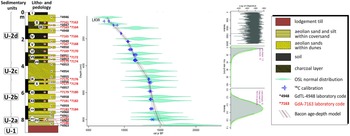
Litho- and paedology with chronology of the aeolian-soil sequence at the Łaskarzew site and Bacon age-depth model based on OSL and radiocarbon (14C) dating results. The Roman numbers from I to XV indicate organic horizons.

Material and methods
Lithological and pedological analyses
The description of sand and fossil soil profiles on dunes followed international standards outlined in the Soil Description Manual (2006), providing a structured framework for characterizing soil profiles based on their parent material and formation processes. Sands were assessed for their textural properties, sorting, and stratification, with particular attention to aeolian or fluvioglacial origins, using a systematic, horizon-by-horizon approach. Geological descriptions, lithofacial analyses, and palaeosol examinations complemented soil analyses, with depositional units classified according to Zieliński and Issmer’s methodology (Reference Zieliński and Issmer2008) and the FAO-WRB system (IUSS Working Group WRB 2015). Detailed measurements, including soil thickness, color, and diagnostic horizons (e.g., humic, eluvial, podzolic), were conducted, highlighting pedogenic processes through indicators such as carbonates or iron oxides. Biological activity, root abundance, and soil consistency were also evaluated to infer past environmental conditions. Fieldwork involved cleaning profiles to expose fresh horizons and systematically collecting samples for laboratory analyses, facilitating a comprehensive understanding of soil stratigraphy and the processes shaping the soils and dunes.
Grain size and heavy minerals analysis
The research incorporated heavy mineral and grain size analyses to enhance understanding of the sedimentary characteristics, formation processes, paleoenvironment, and paleogeographic history of the aeolian sediments. A total of 18 sand fraction samples (0.125–0.25 mm) were selected for heavy mineral analysis, with minerals separated using sodium polytungstate (density 2.85 g/cm3) and identified following Mange and Maurer (Reference Mange and Maurer1992). A total of at least 300 transparent minerals were identified in each sample, including both non-resistant minerals (e.g. amphibole, pyroxene, biotite) and resistant minerals (e.g. garnet, zircon, rutile). Three statistical coefficients were calculated: NR/R (non-resistant to resistant minerals) and G/R (garnets to resistant minerals). Grain size analyses were conducted on samples collected from the same locations as the heavy mineral and OSL samples. A Malvern Mastersizer 2000 laser diffraction particle size analyzer was employed for this purpose. The procedure entailed a series of chemical treatments aimed at removing organic matter and carbonates. This was followed by a dispersion process, the purpose of which was to prevent aggregation. Statistical parameters such as mean grain size, sorting, skewness, and kurtosis were calculated using Gradistat 9.1 software (Blott and Pye Reference Blott and Pye2001), following Folk and Ward’s methodology (Reference Folk and Ward1957). The visualization of grain size subfractions was achieved through the use of heatmaps, which displayed particle size distributions across 100 classes with a color gradient to enhance clarity. The integrated approach yielded comprehensive insights into the composition of the sediments and the depositional processes involved.
Spectrophotometry
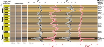
In the field, samples were collected directly from the exposure at 4 cm intervals as bulk samples. In the laboratory, dried material and powdered sediment samples were analyzed with a 3ColorSFX50 spectrophotometer (10° observation angle, D65 standard light) to capture lightness (L∗), green-red (a∗), and blue-yellow (b∗) values, which reflect pigment composition and chromaticity (c.f. Sprafke et al. Reference Sprafke, Schulte, Meyer-Heintze, Händel, Einwögerer, Ulrich, Peticzka, Schäfer, Lehmkuhl and Terhorst2020). The L∗ parameter indicates brightness, with lower values linked to dark particles such as charcoal or organic-rich A-horizons, while a∗ and b∗ reveal variations in iron oxide content and post-depositional processes. The b*/a* ratio highlights the balance between yellow and red hues, offering insights into soil composition, weathering, and pigment distribution. RGB tuning (fourth step, max) was applied as per Sprafke et al. (Reference Sprafke, Schulte, Meyer-Heintze, Händel, Einwögerer, Ulrich, Peticzka, Schäfer, Lehmkuhl and Terhorst2020), and colors were converted into the Munsell Colour System (2° observation angle, C light type) for standardized coding. In the Munsell system, Hue (H) represents the dominant wavelength, Value (V) denotes brightness, and Chroma (C) indicates color intensity (Munsell Color 2009). Data processing with Colour QC software (version 2.79.0.0; 3Color, 2017) enabled a comprehensive characterization of sediment color properties, facilitating interpretations of depositional and post-depositional conditions, including environmental and diagenetic influences on pigment dynamics.
Radiocarbon dating procedures
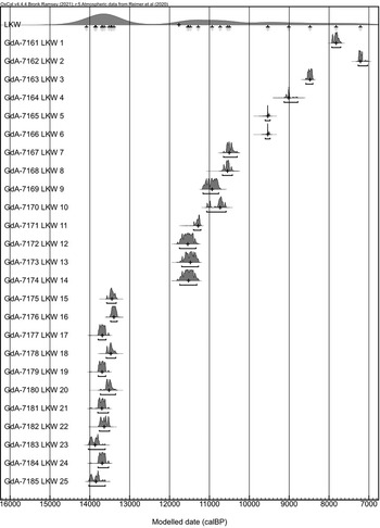
Charcoal is widely regarded as an excellent medium for radiocarbon dating due to its relative inertness (Preston and Schmidt Reference Preston and Schmidt2006; Schmidt and Noack Reference Schmidt and Noack2000), which helps to avoid many of the challenges associated with dating other forms of soil organic carbon that decompose over time (Matthews Reference Matthews, Richards, Arnett and Ellis1985). The preservation of buried charcoal-rich horizons in dune formations demonstrates that charcoal can endure over Holocene timescales. To ensure the reliability of the results, and account for possible inhomogeneity of charcoal ages, two independent samples were collected from each layer containing charcoal or organic material within the fossil soils. For identifying the age of the studied sediments, 26 charcoal samples were collected from fossil soils and charcoal layers (2 samples from each organic layer) for the radiocarbon method.
The chemical pretreatment samples for 14C dating focused on retrieving a measurable amount of carbon from generally low-carbon-content material, utilizing the fraction which would yield reliable radiocarbon ages. Before material collection all sediment samples were analyzed using an optical microscope with attached high-quality digital camera to carry out a preliminary characterization of the organic material contained in the sample. From all samples charcoal fragments ranging from 1 to 2 mm in diameter were hand-picked for further analysis. Selected charcoal was treated using ABA (acid-base-acid) protocol to remove potential contaminants like carbonates and humic compounds (0.5M HCl, 0.1 M NaOH and 0.5M HCl, 85 °C for 1 hr respectively). After rinsing with demineralized water to a neutral pH, the samples were dried. Subsamples of the extracted material were packed into tin capsules, combusted in a Vario Micro Cube Elementar™ elemental analyzer, and then graphitized using an AGE-3 system (Němec et al. Reference Němec, Wacker and Gäggeler2010; Wacker et al. Reference Wacker, Němec and Bourquin2010a). In the graphitization process, 1 mg of carbon was obtained for each sample. Before measurement, each graphite sample was pressed into a cathode. The radiocarbon concentration in the graphitized samples was then measured using the MICADAS accelerator mass spectrometer at the Gliwice Radiocarbon Laboratory (Synal et al. Reference Synal, Stocker and Suter2007; Ustrzycka et al. Reference Ustrzycka, Piotrowska, Kłusek, Pawełczyk, Michczyńska, Michczyński, Kozioł and Jędrzejowski2025). This modern, small device (3.2 m × 2.6 m) has a magazine that can hold up to 40 graphite targets. Oxalic Acid II (NIST SRM4990C) was used as a modern reference material, and Phthalic Anhydride (Sigma-Aldrich) was used as a background material. In addition to samples of unknown radiocarbon age, background and standard samples, secondary IAEA (International Atomic Energy Agency) standards were measured to control the accuracy of the measurements and analyzed as unknown samples (Ustrzycka et al. Reference Ustrzycka, Piotrowska, Kłusek, Pawełczyk, Michczyńska, Michczyński, Kozioł and Jędrzejowski2025). The radiocarbon age and their uncertainty were calculated using BATS software (Wacker et al. Reference Wacker, Christl and Synal2010b). All 14C results were calibrated using the OxCal program (Bronk Ramsey Reference Bronk Ramsey2009) and the IntCal20 calibration curve (Reimer et al. Reference Reimer, Austin, Bard, Bayliss, Blackwell, Bronk Ramsey, Butzin, Cheng, Edwards, Friedrich, Grootes, Guilderson, Hajdas, Heaton, Hogg, Hughen, Kromer, Manning, Muscheler, Palmer, Pearson, Van Der Plicht, Reimer, Richards, Scott, Southon, Turney, Wacker, Adolphi, Büntgen, Capano, Fahrni, Fogtmann-Schulz, Friedrich, Köhler, Kudsk, Miyake, Olsen, Reinig, Sakamoto, Sookdeo and Talamo2020). The results are presented in Table 1. Hereafter for simplicity and clarity the median of calibrated age range is used, and sigma as a measure of the uncertainty.
Radiocarbon dating results (conventional and calibrated ages) for the Łaskarzew profile.

In addition, to present our chronology on a depth scale, age-depth modelling was applied, combining all radiocarbon and OSL dates in Bacon software (Blaauw and Christen Reference Blaauw and Christen2011). The calculations were performed in R (“rbacon” version 3.5.2). The deposit was divided into 162 5-cm thick sections, and 20k iterations were used to obtain satisfactory model performance. The model plot is presented in Figure 2, and the details in Supplement 2.
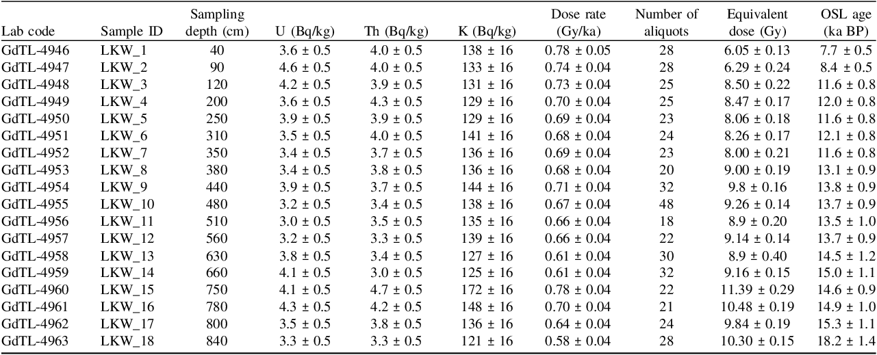
OSL dating: Analytical procedures and dose rate calibration
All eighteen samples were analyzed in the Gliwice Luminescence Laboratory using standard procedures (Moska et al. Reference Moska, Bluszcz, Poręba, Tudyka, Adamiec, Szymak and Przybyła2021) and OSL method (optically stimulated luminescence). For OSL measurements, grains of quartz were extracted from the sediment samples by treatment with 20% hydrochloric acid (HCl) and 20% hydrogen peroxide (H2O2) to remove carbonates and organic matter form the samples. The quartz grains were separated using density separation with the application of sodium polytungstate solutions leaving grains of densities between 2.62 g/cm3 and 2.75 g/cm3. The grains were sieved, before etching with concentrated hydrofluoric acid (HF). For equivalent dose measurements grains with diameter from 125 µm to 200 µm were used.
For the determination of dose rates, high-resolution gamma spectrometry was employed, utilizing an HPGe detector manufactured by Canberra (25% rel. efficiency) and using new counting beakers (γBeaker, Poręba et al. Reference Poręba, Tudyka, Walencik-Łata and Kolarczyk2020) filled with 100–150 g of sample. The HPGe detector was placed in a 747 lead shield produced by Canberra. The measurement took at least 160 ks, calibrated with International Atomic Energy Agency reference materials RGTh-1, RGU-1, and RGK-1. This approach determined the U, Th, and K content in the samples following the laboratory protocol (Moska et al. Reference Moska, Bluszcz, Poręba, Tudyka, Adamiec, Szymak and Przybyła2021). Dose rates were computed through an online dose rate calculator (Tudyka et al. Reference Tudyka, Koruszowic, Osadnik, Adamiec, Moska, Szymak, Bluszcz, Zhang, Kolb and Poręba2023), which incorporates the latest conversion factors. We assumed that the average water content was (7±3)%, only for the deepest sample water content was increased to (12±3)% because this sample is placed only 20–30 cm above the glacial till which practically does not allow water to pass through. All necessary data for dose rate calculations are presented in Table 2.
Key parameters and results of luminescence dating.

All OSL measurements were performed using automated luminescence readers fitted with a calibrated 90Sr/90Y beta source, and a 6 mm Hoya U-340 filter was mounted during OSL measurements. Equivalent doses were determined using the single-aliquot regenerative-dose (SAR) protocol (Murray and Wintle, Reference Murray and Wintle2000). Final equivalent dose (D e ) values were calculated for all samples using the Central Age Model (CAM) or Minimum Age Model (MAM) (Galbraith et al. Reference Galbraith, Roberts, Laslett, Yoshida and Olley1999) using R package ‘Luminescence’ (Kreutzer et al. Reference Kreutzer, Burow, Dietze, Fuchs, Schmidt, Fischer, Friedrich, Riedesel, Autzen and Mittelstrass2020). The equivalent dose distributions are presented as relative probability density functions (Berger Reference Berger2010). An overdispersion parameter was calculated for all samples. For three samples (GdTL-4946, GdTL-4947, GdTL-4958) dose distributions are not unimodal, and for these samples the MAM model was applied for final equivalent doses calculation. For these samples the tested material can be assumed to represent groups of partially bleached quartz (Moska et al. Reference Moska, Jary, Adamiec and Bluszcz2019).
Much more challenging was obtaining the correct dose rate for the samples. This difficulty arose due to very low natural radionuclide activity, which, for this site, is lower compared to other locations on Polish dunes where similar measurements have been conducted in the past (Kruczkowska et al. Reference Kruczkowska, Błaszkiewicz, Jonczak, Uzarowicz, Moska, Brauer, Bonk and Słowiński2020; Moska et al. Reference Moska, Jary, Sokołowski, Poręba, Raczyk, Krawczyk, Skurzyński, Zieliński, Michczyński, Tudyka, Adamiec, Piotrowska, Pawełczyk, Łopuch, Szymak and Ryzner2020, Reference Moska, Sokołowski, Jary, Zieliński, Raczyk, Szymak, Krawczyk, Skurzyński, Poręba, Łopuch and Tudyka2022; Rychel et al. Reference Rychel, Woronko, Błaszkiewicz and Karasiewicz2018). Due to the very low count values for the analyzed dune sand samples, a detailed analysis of the detector’s background variability was conducted. This was particularly important, because, given the low activity levels of the sediment samples under study, even slight fluctuations in background counts could have a significant impact on the final value. For this purpose, a statistical analysis of the radioactive background for individual gamma lines was performed, revealing a high variance in background count numbers. A chi-square test was used to assess consistency, based on which the background fluctuations were determined. The calculated background overdispersion was incorporated into the final uncertainty calculations of the activity of individual radioisotopes, as presented in Table 2. Such an advanced approach to determining the correct dose rate values for the analyzed radioisotopes was necessary due to significant challenges in interpreting the results using standard measurement procedures.
Results
Lithology, pedogenesis, and charcoal horizons
In the studied 9-metre thick profile, two primary depositional units were identified (Figures 2 and 3). The lower unit, extending to 0.5 m, consists of brown sandy till with its basal boundary not exposed. The upper unit, 8.5 m thick, contains four distinct subunits. The lower subunit (U-2a), 0.8 m thick, is composed of sand with horizontal bedding and silty wavy lamination, within which a soil horizon has formed. This subunit is separated from the overlying deposits by a deflation surface 10 cm above the soil horizon. The upper part (U-2b, U-2c, U-2d) consists of high-angle inclined sand, interbedded with palaeosols and charcoal-rich horizons. All components of the upper unit dip toward the south (Figure 3).
Sedimentological analysis results in Łaskarzew site: (A) litho- and pedological characteristic; (B) grain size variability and indicators according to Folk and Ward (Reference Folk and Ward1957); the background of the grain size curves includes a heatmap reflecting the percentage distribution of particles divided into 100 size classes. The heatmap provides a detailed visualization of the proportions of individual grain size fractions: C – clay, Si – silt, S – sand, as well as subfractions: f – fine, m – medium, and c – coarse; (C) heavy mineral distribution, along with NR/R (non-resistant to resistant) and G/R (garnets to resistant) indices; (D–F) analyzed sand-palaeosol sequence. Lithological codes: Si – sand with hight-angle inclined stratification, Sh – sand with horizontal stratification, Fw – silt with wavy lamination. For explanations of litho- and pedological symbols, see Figure 2.

The sediment profile at the Łaskarzew site comprises two buried soil units, which exhibit a typical A-E-B-C sequence structure. The A horizon is distinguished by a dark grey coloration and a fine-grained structure, indicative of a high organic matter content, with numerous charcoal fragments. Its thickness varies between 5 and 15 cm. The eluvial E horizon is distinguished by its vivid, nearly white hue and loose texture, which are indicative of vigorous podzolization processes involving soluble components. The thickness of this horizon varies between 3 and 10 cm, and subtle podzolic streaks, which contrast sharply with the surrounding sediments, are observed within it. The B horizon, which is also referred to as the enrichment horizon, is characterized by brown pigmentation. Its thickness varies between 5 and 20 cm, exhibiting secondary ferruginous laminations, as well as small fragments of charcoal distributed evenly in thin lenses. The base of the profile consists of sands, which form the parent material (C horizon) for these soils. The analysis of the soil units revealed indications of post-pedogenic disturbance, characterized by deflation, colluviation, and bioturbation.
The profile contains eleven independent charcoal-rich horizons associated with fire episodes, marked by distinct grey-black strata or lenses ranging from a few to several centimeters in thickness, and containing well-preserved charcoal particles measuring 1 to 2 mm in diameter. The exceptional preservation of the charcoal material ensures its clear visibility and distinct identification within the profile sections. However, in some locations, these horizons are modified by intensive bioturbation caused by fauna and flora, such as tree roots, earthworms, or small mammals, as evidenced by numerous burrows ranging from 1 to 3 mm in diameter, which indicate soil fauna activity during periods of surface stabilization.
Grain size distribution and heavy minerals analysis
The sediments are characterized by a medium grain size, with a mean of 372.4 µm and a range from 344.5 to 902.1 µm (Figure 3; Supplement 1). Moderate sorting (average: 1.54) suggests a consistent transport mechanism, likely wind-driven aeolian processes typical of dune environments, although some variability is evident (range: 1.39 to 1.79). The symmetrical skewness (mean: –0.03, ranging from –0.19 to +0.02) indicates a balanced sediment distribution, with no significant dominance of either fine or coarse material. Meanwhile, the mesokurtic kurtosis (mean: 0.94, ranging from 0.92 to 1.11) reflects a moderate concentration of grain sizes around the mean, supporting the interpretation of relatively uniform depositional energy conditions.
Most of the samples are dominated by medium sand fractions, which typically constitute over 50% of the total sediment composition (Figure 3B). Fine sand fractions are consistently present, although in lower percentages, suggesting a secondary role in the overall sediment distribution. oarse sand fractions are rare; however, unit U-2a stands out with a mean grain size of 902.1 µm, distinctly classifying it as coarse sand and reflecting unique depositional conditions. Heatmaps for each sample display unimodal distributions, further emphasizing the dominance of medium sand fractions across most of the profile. The mean grain size shows minor variability, ranging from 344.5 µm to 415.1 µm within the medium sand class, except lower part of subunit U-2b. Sorting is relatively stable throughout the profile, with most samples categorized as moderately well sorted, although some transitions to moderately sorted are observed (e.g., units U-2a and U-2c). Skewness generally indicates symmetrical distributions, but finer skewness is noted in the lower profile, particularly in unit U-2a. Kurtosis values are predominantly mesokurtic across the profile, with minor variations such as leptokurtic tendencies in unit U-2a.
The morphology, surface micro-textures, and low mineral maturity of the heavy minerals in the aeolian sediments retain evidence of past sub-aquatic environments and localized aeolian transport. Analysis of the heavy minerals indicates a high levelling of their composition (Figure 3C; Supplement 1). The dominant minerals are garnets (GAR), whose content varies from 37% in the lower part of the profile to 56-59% in the upper part of the profile. The second group of minerals in terms of frequency are amphiboles (AMF—7.3% to 25%), epidote minerals (EPI—5.8% to 14%) and staurolite (STA—6.3% to 13%). The content of other minerals does not exceed a few percent.
Spectrophotometric analysis
The L* values range from 45.73 to 70.09 (Figure 4; Supplement 1), indicating moderate to high brightness, with an average of 61.53. The a* values range between 0.2 and 5.68, averaging 3.51, while b* varies from 1.8 to 20.78, with an average of 14.23. The b*/a* ratio spans from 3.20 to 9.00, averaging 4.32, demonstrating moderate chromaticity variations. The analysis of H (Hue) parameters reveals a dominance of yellowish-brown shades, with “10YR” hues prevalent in 54.7% of samples, characterized by a yellowish-brown color, and “2Y” hues present in 23.1%, displaying a more intense yellow tone indicative of moderate iron oxide content. Less frequent hues, such as “7YR” and “6YR” (9.5% combined), show brownish tones, while “R” (Red) and “RP” (Red-Purple) hues, representing 5.5% and 4.2% of the samples, respectively, are associated with reddish and reddish-purple tones, likely reflecting variations in organic content or specific mineral inclusions. The V (Value) parameter correlates with H, with “10YR” hues exhibiting brighter tones and darker shades observed in less common hues like “7YR,” “6YR,” “R,” and “RP.” The C (Chroma) parameter indicates higher color intensity in the less common hues, with “7YR,” “6YR,” “R,” and “RP” hues showing greater vividness compared to the dominant yellowish hues.
Spectrophotometric parameters shown against the maximum RGB tuning stage. The figure illustrates four stages of RGB tuning, highlighting the variability of spectrophotometric data within the stratigraphic context. Munsell colors, provided only for selected samples and rounded to whole values, are detailed in Supplement 1. For explanations of lithological and pedological symbols, see Figure 2.

The above description allows for a more precise characterization of the colors of the soil horizons, which reflect the activity of pedogenic processes: dark grey and black for A horizons, grey to white for E horizons, and reddish-brown for B horizons. The sands are characterized by a yellow hue. Well-developed charcoal-rich layers exhibit black, and in some cases, reddish or reddish-purple colors (units XII and XIII).
Radiocarbon results
The details of sample preparation, radiocarbon results and calibration are included in Supplement 2. As presented in figures 3A and 5, the ages of the charcoal layers and palaeosol horizons are generally in chronological order. The differences in radiocarbon dates between levels are within the range of uncertainty of the results. Mostly pairs of dates obtained from the same layer are very close to each other. The first charcoal horizon (XIII) was presumably formed 13,800–13,700 ± 80 cal BP. The older date in this horizon (LKW-23, 13,868 ± 91 cal BP) is identical to the result from sample LKW-25 (13,844 ± 102 cal BP), which allows us to assume that this is redeposited material from the palaeosol below (horizon XIV). The other charcoal and palaeosol layers are separated by a difference of 180 to 70 calendar years. However, the recurrence of the same radiocarbon dates (ranging from 13,700 to 13,400 cal BP) in the different layers from XII to IX should be highlighted. This may indicate redeposition of charcoals from one layer to another.
Calibrated radiocarbon ages of charcoal from Łaskarzew dune profile.

Radiocarbon ages from sub-unit U-2d are arranged chronologically but with evidence of charcoal redeposition from older levels. This is particularly pronounced for horizons VIII and VII (LKW-12, 11,544 ± 112 cal BP) as well as VI and V (LKW-8, 10,547 ± 61 cal BP). The onset of fire events was 1,1544± 112 cal (LKW-12 BP), followed by 11,477 ± 111 cal BP (LKW-13) and 11,282 ± 55 cal BP (LKW-11). Further fire episodes occurred at 10,934 ± 112 cal BP (LKW-9) and 10,547 ± 61 cal BP (LKW-8). Very similar result from the horizon V (LKW-7, 10,501 ± 68 cal BP) leads us to believe that they represent the same fire event, as their uncertainty ranges overlap. The end of the soil process activity of horizon IV is well documented, where both samples yielded identical results (LKW-5 and 6, 9536 ± 29 cal BP). The two uppermost charcoal layers (II and III) indicate presumably four fire episodes. These occurred at 9010 ± 78 cal BP, 8472 ± 41 cal BP, 7822 ± 55 cal BP and 7212 ± 55 cal BP (Figure 3A).
Luminescence results
In order to accurately determine the luminescence age of the studied sediments, it is crucial to establish two fundamental values: dose rate and equivalent dose. Equivalent doses are represented by dose distribution graphs (Figure 6), in the case of the current study, these results are of high quality and generally straightforward to interpret. Usually more than 20 aliquots were measured for each sample and for each aliquot luminescence parameters like recuperation and recycling ratios were checked during SAR procedure.
Distribution of the relative probability density function for luminescence dating results of all investigated samples.

Small variations in the annual dose (see Table 2), ranging from 0.60 to 0.78 Gy/ka, indicate that there was no significant accumulation of grains originating from distant sources at this site. Such grains often exhibit markedly different luminescence properties, as commonly observed in fluvio-aeolian or fluvial deposits, where changes in annual dose measurements can exceed 100% (Szymak et al. Reference Szymak, Moska, Sokołowski, Poręba and Tudyka2024).
From a measurement standpoint, it was crucial to closely monitor background fluctuations in the measurement devices. This is because the actual counts in semiconductor spectrometers for certain measurement channels are only marginally higher than the background levels at such low activities. Statistical analysis of the radioactive background across individual gamma lines proved invaluable, revealing substantial variability in background counts over time.
The luminescence dates are generally in chronological order within the profile (Figure 3A). Relatively insignificant date inversions relative to the above- and below-mentioned samples apply to the results of GdTL-4951 (12.1 ± 0.8 ka BP) and GdTL-4959 (15.0 ± 1.1 ka BP). However, these results are within the dating uncertainties and within the trend curve (Figure 2). In relation to the radiocarbon dates, the average OSL dating values are mostly slightly older but overlap within their uncertainty limits. This allows us to assume that the OSL dating is coherent with the radiocarbon dating results. Due to their much larger uncertainty range, they have an auxiliary and control character in relation to radiocarbon dating. In our view, if we encounter a situation akin to the Łaskarzew profile, where equivalent dose distributions appear satisfactory, the issue likely resides in accurately determining the annual dose. However, identifying specific elements for improvement in our calculations lacks a straightforward explanation.
Discussion
Aeolian sediment dynamics
The shape of the studied dune suggests that it migrated in the past, despite the stabilization of its arms by vegetation (Figure 1B). The migration of the dune’s nose is delineated by the reach of its arms and the position of residual dune ridges. This spatial configuration indicates that the nose has advanced by approximately 2 km. Considering the present-day migration rates of parabolic dunes under similar environmental conditions—such as those reported in Canada—they range from 2.2 m/year (David et al. Reference David, Wolfe, Huntley and Lemmen1999) to 3.4 m/year (Hugenholtz et al. Reference Hugenholtz, Wolfe and Moorman2008; Yan and Baas Reference Yan and Baas2015). Based on these values, the Łaskarzew dune would have required between ca. 600 and 900 years to traverse the observed distance, excluding periods of stabilization during which vegetation colonized the surface and soil development occurred.
The final stabilization of the dune was forced by an increase in the soil moisture as documented by residual dune ridges (Lindhorst and Reimann Reference Lindhorst and Reimann2021). Additionally, these secondary forms suggest a shift in the direction of dune migration. Initially, the dune was migrating towards SE for a distance of 2 km and finally turned to ESE and moved about 700 m. The sedimentary profile located in the southern arm records deposits that document the development of the dune, most likely starting from the point when the migration direction of the dune front changed.
The differentiation of aeolian subunits indicates their deposition under different environmental conditions. Sand with horizontal stratification (U-2a) results from the deposition of material from near-surface suspension, whereas silt with wavy lamination is formed by deposition on a moist surface when the wind’s carrying capacity significantly decreases. Such conditions are typical for the formation of aeolian covers (Koster Reference Koster1988; Lea Reference Lea1990; Schwan Reference Schwan1986). Recent findings from the Moravian Sahara dunes (Czech Republic) suggest that episodic aeolian activity occurred under influence of katabatic winds originating from the Scandinavian Ice Sheet (SIS). These dynamics are consistent with observations in Central Europe, where alternating wind regimes controlled sediment deposition (Holuša et al. Reference Holuša, Nývlt, Woronko, Matějka and Stuchlík2022, Reference Holuša, Moska, Nývlt and Woronko2024). In contrast, sand with high-angle cross-stratification (subunits U-2b-d) was formed by the avalanching of sand packages on the lee slope of the dune (Lancaster Reference Lancaster1995; Lea Reference Lea1990). Interbedded layers of charcoal are a result of the same process; however, it is also possible that they were deposited by backflow currents (Matthews and Seppälä Reference Matthews and Seppälä2014; Moska et al. Reference Moska, Sokołowski, Zieliński, Mroczek, Piotrowska, Jary, Raczyk, Szymak, Wojtalak, Poręba, Łopuch, Skurzyński, Krawczyk, Tudyka, Ustrzycka and Hrynowiecka2023b).
These stratigraphic variations reveal the interplay between deposition under stable conditions and episodic disruptions linked to short-term environmental changes. Investigations of aeolian series in Poland suggest such episodic nature, where significant aeolian activity occurred during the Late Glacial and Holocene, influenced by climatic ameliorations and vegetation cover (Moska et al. Reference Moska, Sokołowski, Jary, Zieliński, Raczyk, Szymak, Krawczyk, Skurzyński, Poręba, Łopuch and Tudyka2022). The predominance of medium sand fractions throughout the profile, interrupted by episodic shifts in grain size, highlights the sensitivity of the aeolian system to short-term variations in energy conditions, likely driven by climatic oscillations or local environmental factors. The episodic presence of coarse sand fractions (LKW_15 with a mean grain size of 902.1 µm), reflects high-energy depositional events. These events are interpreted as resulting from sudden increases in wind velocity that led to the deposition of coarser material at the leeward slope of the dune (Łapcik et al. Reference Łapcik, Ninard and Uchman2021). This highlights periods of environmental instability within the dune system, which are in contrast to the generally stable conditions under which most of the dune was formed.
The composition of heavy minerals in the Łaskarzew site is remarkably homogeneous, suggesting a single primary source; however, some variability in mineral proportions indicates potential differences in local depositional conditions or source material contributions. The dominance of garnets (averaging 49%) and the significant presence of amphiboles and pyroxenes indicate that the primary source of these sediments was Quaternary deposits, specifically meltwater sands, gravels, associated with the SIS. These Quaternary sediments are known for their high content of non-resistant minerals, such as amphiboles and pyroxenes (Marcinkowski Reference Marcinkowski2007; Pisarska-Jamroży et al. Reference Pisarska-Jamroży, van Loon and Woronko2015). Following their initial deposition, these sediments underwent repeated fluvial redeposition, leading to a gradual depletion of non-resistant minerals (Weckwerth and Chabowski Reference Weckwerth and Chabowski2013).
The NR/R ratio, consistently low throughout the profile (0.11–0.43), underlines the dominance of highly resistant minerals such as garnets and staurolite, indicative of long-term transport and sorting under high-energy aeolian conditions that removed non-resistant components. In contrast, the A/G (amphiboles to garnets) ratio exhibits greater variability (0.12–0.69), with higher values in samples like LKW-15 and LKW-16 reflecting a relatively higher proportion of less resistant amphiboles (Figure 3C). Similar mineralogical studies from other regions of the European Sand Belt reveal consistent patterns of heavy mineral composition, indicating comparable sediment sources and aeolian transport dynamics across Central Europe (Moska et al. Reference Moska, Sokołowski, Jary, Zieliński, Raczyk, Szymak, Krawczyk, Skurzyński, Poręba, Łopuch and Tudyka2022).
The apparent enrichment of garnets in the upper parts of the Holocene profile suggests that these layers predominantly consist of redeposited aeolian sediments. This phenomenon likely reflects a substantial reduction in external sediment supply, possibly driven by the establishment of dense vegetation cover in the surrounding area during the Holocene. However, differences in the ratios of non-resistant to resistant minerals (NR/R) and amphiboles to garnets (A/G) indicate localized shifts in the balance of sediment sources and depositional processes during certain phases. Analysis of the surficial geological structure and relief of the studied area together with the dominant direction of transport of aeolian sediments during the Late Glacial (Łopuch et al. Reference Łopuch, Sokołowski and Jary2023a; Zieliński Reference Zieliński2016) indicates that the most probable sources of sediment building the dune at the Łaskarzew site were the accumulation terraces of the Vistula River and the alluvial fan of the Promnik River (Figure 1). These sediments are located about 4-5 km to the west of the studied dune. The results of the analysis of heavy minerals allow to assume that potential other sources of sediment for the dune (glacial till and glacifluvial sands) were of negligible importance. The dominant role of fluvial terraces in sand supply was widely reported within and beyond the ESB (Holuša et al. Reference Holuša, Moska, Nývlt and Woronko2024; Kasse et al. Reference Kasse, Vanderberghe, De Corte and Van Den Haute2007, Reference Kasse, Woolderink, Kloos and Hoek2020; Łopuch and Jary Reference Łopuch and Jary2023; Marković et al. Reference Marković, Perić, Gavrilov, Marković, Vandenberghe, Schaetzl, Obreht, Bartyik, Radaković, Radiovojević, Marjanović, Lukić and Sipos2024).
OSL and 14C chronology of the dune development
The relatively numerous organic and aeolian interbeds allowed detailed stratigraphic research interpretations. As a result, four main phases of AOC formation were distinguished: Late Pleniglacial, Bølling-Allerød, Younger Dryas and Holocene. The main events during these phases of dune development and their relation to environmental and climate change are presented in Figure 7.
Main events of the Łaskarzew dune record in the context of NGRIP stratigraphy (Rasmussen et al. Reference Rasmussen, Bigler, Blockley, Blunier, Buchardt, Clausen, Cvijanovic, Dahl-Jensen, Johnsen, Fischer, Gkinis, Guillevic, Hoek, Lowe, Pedro, Popp, Seierstad, Steffensen, Svensson, Vallelonga, Vinther, Walker, Wheatley and Winstrup2014).

Phase I—Late Pleniglacial
The onset of depositional processes is marked by the presence of aeolian sand covers beneath the sediments of the dune’s distal slope. These were deposited by variable winds, as indicated by the thin silty overlays within the sands. The balance of sediment was controlled by wind strength, combined with the absence of vegetation cover (Pye and Tsoar Reference Pye and Tsoar2009; Courrech du Pont et al. Reference Courrech du Pont, Rubin, Narteau, Lapôtre, Day, Claudin, Livingstone, Telfer, Radebaugh, Gadal, Gunn, Hesp, Carpy, Bristow, Baas, Ewing and Wiggs2024). This resulted in low persistence of deposited sediments and their systematic redeposition. The OSL age (18.2 ± 1.4 ka BP) obtained indicate that these processes were still occurring during the Late Pleniglacial, a period when periglacial conditions prevailed. The presence of permafrost reduced the amount of available sediment; hence, conditions were not conducive to the formation of thicker aeolian deposits (Goździk Reference Goździk1991; Kasse Reference Kasse2002). Deposition of aeolian and fluvio-aeolian covers is characteristic of the end of the last glaciation (Vandenberghe et al. Reference Vandenberghe, Derese, Kasse and Van den Haute2013; Zielinski et al. Reference Zieliński, Sokołowski, Woronko, Jankowski, Fedorowicz, Zaleski, Molodkov and Weckwerth2015). Recent studies suggest that climatic disturbances, such as those triggered by volcanic activity, may have temporarily intensified aeolian processes during this period. The eruption of the Laacher See volcano, dated to approximately 12.9 ka BP, introduced significant amounts of tephra into the environment, altering sedimentary dynamics and influencing the availability of fine-grained material for aeolian transport in Central Europe (Warken et al. Reference Warken, Cheng, Edwards, Spötl and Breitenbach2025).
The results obtained at the Łaskarzew site support the thesis that prior to the Late Glacial, conditions were not favorable to an adequate supply of sandy sediment to form dunes. This casts doubt on earlier assumptions that dunes could have developed in the central part of the ESB during the so-called Oldest Dryas (Dylikowa Reference Dylikowa and Galon1969; Konecka-Betley Reference Konecka-Betley2012). The onset of accumulation at Łaskarzew occurred no earlier than the Bølling interstadial.
Phase II—Bølling-Allerød interstadial
A shift in environmental conditions and significant warming from the subarctic to boreal climate at the beginning of the Bølling period initiated gradual changes in the studied area. Aeolian deposits began to be colonized by lichens and pioneer plants, which triggered the onset of soil-forming processes and led to the development of thin arctic soils (Konecka-Betley Reference Konecka-Betley2012). These initial plant covers were subsequently overlain by layers of aeolian sands, which were later recolonized by vegetation. This cycle resulted in the formation of thin but relatively well-developed soil profiles, exhibiting a typical A-E-B-C sequence structure. The enrichment horizon (B) is particularly well-preserved, clearly visible through its reddish coloration, which unequivocally indicates its character as a zone of material accumulation. Radiocarbon ages from the lowest soil assemblage suggest that its development occurred by the end of the Bølling period (14,084 ± 96 cal BP) and possibly into the beginning of the Allerød period (13,844 ± 102 cal BP). The humus layers contain only trace amounts of charcoal, suggesting a relatively minor role of wildfires in shaping the aeolian environment. This can likely be attributed to the vegetation cover, which comprised open grass communities interspersed with clumps of Betula and the gradual encroachment of Pinus sylvestris. Additionally, there was a significant presence of pioneer deciduous trees such as Salix and Populus tremula (Wacnik Reference Wacnik2009; Lewandowska et al. Reference Lewandowska, Milecka, Niedzielski, Czerwinski and Gałka2023).
The OSL dates from the dune base (14.6 ± 0.9 ka BP and 15.0 ± 1.1 ka BP) appear older than the radiocarbon dates from both the fossil soil below the dune base and the charcoal-rich horizon at the bottom of the dune (13,868 ± 91 cal BP and 13,689 ± 66 cal BP). This relatively small difference between radiocarbon and OSL dating results persists throughout almost the entire profile (Figure 7). Hence, the stratigraphic pattern of sedimentary and organic succession at the Łaskarzew site is based primarily on radiocarbon dates. An important question is when the main dune mass was formed. In this regard, it is imperative to acknowledge that the sediment exposure is situated on the distal side of the southern arm of the dune. This suggests that the primary component of the dune arm manifests at the lower end of the exposure, being obscured by a succession of AOCs that merely modify an existing form. On the basis of this assumption, it can be inferred that the dune front appeared at this location during the middle part of the Allerød period and has since migrated a further 300 m to the east. This does not exclude the possibility that the studied dune started to form in the Bølling interstadial and migrated until stabilization in the Allerød. Aeolian activity and deposition of coversands in the early part of the Late Glacial is reported from the western part of the ESB and related to slow expansion of plants caused by limited availability of nutrients (Kasse et al. Reference Kasse, Vanderberghe, De Corte and Van Den Haute2007).
The most characteristic feature in the Bølling-Allerød interstadial succession in the Łaskarzew site is the overlying aeolian sands and charcoal-rich palaeosol horizons (AOCs). A total of seven such pairs were found (Figure 3D–F). The charcoal-rich horizons are characterized by varying degrees of bioturbation up to the development of soil processes. The charcoals are remnants of the wildfires that occurred at the time (Figure 7). The results of radiocarbon dating indicate that the fires occurred mainly in the lower and middle Allerød interstadial (13,868 ± 91 cal BP–13,445 ± 55 cal BP). The periods between fires lasted 70–280 calendar years (Figure 7). The main material among the charcoal are most probably Pinus sylvestris fragments, which is typical of the Allerød in the central part of the ESB (Moska et al. Reference Moska, Sokołowski, Zieliński, Mroczek, Piotrowska, Jary, Raczyk, Szymak, Wojtalak, Poręba, Łopuch, Skurzyński, Krawczyk, Tudyka, Ustrzycka and Hrynowiecka2023b). The charcoals are characterized by sizes up to 2 mm and a relatively good degree of preservation. Charcoals from the lower horizons were presumably sometimes redeposited by local deflation of earlier deposited material and mixed with younger material. This is indicated by the distribution of radiocarbon dates in the Łaskarzew profile. Processes of this type may have occurred as a result of periodically changing wind directions, as well as insufficient sand supply to cover the already existing AOC with a thicker layer. Periods of dune stabilization by vegetation cover were interrupted by remobilization of sand by wildfires, something that appears to be a characteristic of dune areas operating under boreal climate conditions (Seppälä Reference Seppälä1981, Reference Seppälä1995; Filion Reference Filion1984). An example of such functioning ecosystems can be found in the boreal forests covering dunes in northern Finland, where the record of fires fueled by conifers (Pinus sylvestris and Picea abies) is well recognized (Matthews and Seppälä Reference Matthews and Seppälä2014; Remy et al. Reference Remy, Fouquemberg, Asselin, Andrieux, Magnan, Brossier, Grondin, Bergeron, Talon, Girardin, Blarquez, Bajolle and Ali2018). As in contemporary boreal areas, a clear correlation between the expansion of Pinus sylvestris and the frequency of fire episodes is evident during the Allerød period. Relatively frequent fires were more characteristic of the cool and wet periods, while less frequent but stronger fires predominated during the warm and dry climatic conditions (Remy et al. Reference Remy, Magne, Stivrins, Aakala, Asselin, Seppä, Luoto, Jasiunas and Ali2023). A comparison of the frequency of surviving evidence of wildfires in the U-2b and U-2d subunits shows a similar pattern, as the early Holocene was clearly warmer than the Bølling-Allerød interstadial (Płóciennik et al. Reference Płóciennik, Mroczkowska, Pawłowski, Kruk, Wieckowska-Lüth, Kurzawska, Rzodkiewicz, Okupny, Szmańda, Mazurkevich, Dolbunova, Luoto, Kotrys, Nazarova, Syrykh, Krąpiec and Kittel2022).
The presence and preservation of AOCs on the distal slope of the dune can be explained by the aerodynamic conditions during this period. The predominant wind direction at the time was from W-NW, which caused currents on the southern arm of the dune to sweep in and lift light charcoal fragments up the dune’s depositional slope. This raises the question of whether the dune at the Łaskarzew site was covered with trees during the Allerød. This possibility may be supported by the results of palynological analyses of reservoir sediments from central and northeastern Poland (Bałaga et al. Reference Bałaga, Goslar, Kuc, Ralska-Jasiewiczowa, Goslar, Madeyska and Starkel1998; Rychel et al. Reference Rychel, Sokołowski, Sieradz, Hrynowiecka, Mirosław-Grabowska, Sienkiewicz, Niska, Szymanek, Zbucki, Ciołko and Rogoż-Matyszczak2023). However, the good state of preservation of charcoals, the absence of evidence for soil material movement (colluvial soils), as well as absence of root structures typical of an area overgrown by Pinus sylvestris, suggest that the dune at Allerød was not covered by trees. This is also indicated by palynological analyses of palaeosols from similar locations in dunes in the central part of the ESB (Konecka-Betley and Janowska Reference Konecka-Betley and Janowska2005; Sokołowski et al. Reference Sokołowski, Mroczek, Piotrowska, Zieliński, Hrynowiecka, Łopuch, Krawczyk, Skurzyński, Jary, Raczyk, Szymak, Poręba, Tudyka, Ustrzycka, Moska, Margielewski and Stachowicz-Rybka2024). Presumably, the dune at Łaskarzew was covered only by herbaceous vegetation and grasses, and trees (mainly pine) grew in the direct vicinity of the dune. Pinus sylvestris, due to its flammability, was the primary fuel for fires, at least some of which were recorded in the aforementioned aeolian sediments studied (Bazelmans et al. Reference Bazelmans, Van Balen, Bos, Brinkkemper, Colenberg, Doeve, van Geel, Hakbijl, van Hateren, Hoek, Huisman, Jansma, Kasse, van Os, van der Plicht, Schokker, Van der Putten and van der Woude2021).
Phase III—Younger Dryas
The significant deterioration of climatic conditions in the Northern Hemisphere (Brauer et al. Reference Brauer, Haug, Dulski, Sigman and Negendank2008; Isarin and Renssen Reference Isarin and Renssen1999; Renssen et al. Reference Renssen, Mairesse, Goosse, Mathiot, Heiri, Roche, Nisancioglu and Valdes2015), which occurred during the Younger Dryas, was also marked in the above-mentioned study area. This period is recorded by the deposition of an almost 1.5 m thick unit of aeolian sands, depleted in organic material. This makes it possible to assume that it was formed as a result of the systematic overburdening of sandy sediments on the distal slope of the dune arm. The absence of charcoal evidence correlates well with the rapid change in vegetation cover that took place at the beginning of the Younger Dryas in Central Europe. Pine and birch forests were replaced by open plant communities, where Juniperus thrived on the sandy substrate at the beginning of this period (Fiłoc et al. Reference Fiłoc, Kupryjanowicz, Suchora, Luoto and Nevalainen2024; Mirosław-Grabowska et al. Reference Mirosław-Grabowska, Obremska, Zawisza, Stańczak, Słowiński and Mulczyk2020).
Only OSL dates (13.8 ± 0.9 ka BP–13.1 ± 0.9 ka BP) come directly from sediments correlated with the younger Dryas, which are more indicative of Allerød as the time of their deposition (Figure 3). A different pattern is shown by radiocarbon dates from charcoals below (13,445 ± 55 cal BP) and above (11,544 ± 112 cal BP) the thick sandy layer. This set of dates allows its correlation with the Younger Dryas. Maximum aeolian activity in the Younger Dryas is recorded mainly from the western part of the ESB and the NE part of Germany within the range of the Last Glacial Maximum (LGM) (Kasse Reference Kasse1997; Kasse and Aalbersberg Reference Kasse and Aalbersberg2019). As Warken et al. (Reference Warken, Cheng, Edwards, Spötl and Breitenbach2025) argue, such changes in aeolian activity may also reflect the impact of distal volcanic events, which influence atmospheric circulation and regional sediment transport dynamics. In the Polish part of the ESB, aeolian activity in the Late Glacial is more complex. Dunes located in the LGM range were thought to have formed mainly in the Younger Dryas (Nowaczyk Reference Nowaczyk1986, Reference Nowaczyk, Chojnicki and Parysek2000). In contrast, dunes from the extraglacial zone were interpreted as having been formed mainly during the Older Dryas (Manikowska Reference Manikowska1985, Reference Manikowska1995). More recent results indicate that dunes in the LGM range may have formed throughout virtually the entire Late Glacial, especially in the case of large dune fields (Łopuch and Jary Reference Łopuch and Jary2023; Łopuch et al. Reference Łopuch, Sokołowski and Jary2023a). Recent research results on dunes from the extraglacial zone suggest that their formation was strongly influenced by local factors and took place mainly in the Bølling-Allerød interstadial (Moska et al. Reference Moska, Sokołowski, Jary, Zieliński, Raczyk, Szymak, Krawczyk, Skurzyński, Poręba, Łopuch and Tudyka2022, Reference Moska, Sokołowski, Zieliński, Jary, Raczyk, Mroczek, Szymak, Krawczyk, Skurzyński, Poręba, Łopuch and Tudyka2023a). In the Younger Dryas, it was mainly the transformation of dunes or their superstructure by successive sediment packages. In contrast, dunes hardly migrated anymore during this period. Presumably this is the situation in the Łaskarzew site.
The decline of forest communities and the dominance of herbaceous plants and grasses had serious consequences for the evolution of the dune at the Łaskarzew site. Firstly, the disappearance of Pinus sylvestris resulted in an absence of vegetative stability, which likely reduced the availability of fuel for extensive fires that impacted the environment during the Allerød period (Bazelmans et al. Reference Bazelmans, Van Balen, Bos, Brinkkemper, Colenberg, Doeve, van Geel, Hakbijl, van Hateren, Hoek, Huisman, Jansma, Kasse, van Os, van der Plicht, Schokker, Van der Putten and van der Woude2021). Secondly, for habitats as difficult to colonize by plants as inland dunes, this meant that the surface of these dunes was exposed and thus deflation processes intensified. It is difficult to assess, in the case of this particular dune, whether aeolian processes only caused a larger package of aeolian sediments to be deposited, or whether they caused the whole dune face to migrate again. However, the latter possibility cannot be ruled out, given that such scenarios have been discussed in relation to the increased susceptibility of open landscapes to aeolian dynamics during climatic transitions in both the central (Kaiser et al. Reference Kaiser, Hilgers, Schlaak, Jankowski, Kühn, Bussemer and Przegiętka2009; Manikowska Reference Manikowska1991; Tolksdorf and Kaiser Reference Tolksdorf and Kaiser2012) and western parts of the ESB (Kasse et al. Reference Kasse, Woolderink, Kloos and Hoek2020; Vandenberghe et al. Reference Vandenberghe, Derese, Kasse and Van den Haute2013).
Phase IV—Holocene
Aeolian and soil-forming processes persisted into the Holocene, as evidenced by the exceptionally abundant assemblage of layers, including fire-related and palaeosol horizons, interbedded with aeolian sands (Figure 4). These findings indicate that aeolian activity occurred periodically during the Holocene, despite the generally more favorable climatic conditions of this epoch (Moska et al. Reference Moska, Sokołowski, Jary, Zieliński, Raczyk, Szymak, Krawczyk, Skurzyński, Poręba, Łopuch and Tudyka2022; Ninard et al. Reference Ninard, Stolarczyk, Łapcik and Uchman2023; Sevink et al. Reference Sevink, Wallinga, Reimann, van Geel, Brinkkemper, Jansen, Romar and Bakels2023; Tolksdorf and Kaiser Reference Tolksdorf and Kaiser2012).
The charcoals contained in the Holocene organic layers are finer compared to material from the Allerød interstadial. This allows us to assume that they are redeposited from the higher part of the dune arm as a result of colluvial processes on the slope. If this is the case, it means that the charcoal-rich horizons and the buried soils functioned over the entire dune surface. These soils exhibit initial stages of podzolization in their very thin E horizons, which are clearly discernible in their coloration. Consequently, unlike during the Late Glacial period, the dune at the Łaskarzew site was entirely covered by trees.
The aeolian deposition processes on the distal slope were of a limited nature, involving the proving of successive portions of sediment after the local exposure of the central and possibly also the proximal part of the dune. Results of textural analyses, especially of heavy minerals indicate redeposition of material only from the dune without significant delivery from its hinterland (Figure 4C). This suggests that, despite the fires still occurring, the vegetation cover around the dune regenerated quickly enough to inhibit the deflation of material from outside the dune.
Increased aeolian activity during the early Holocene was also recorded in other parts of the European Sand Belt (ESB). This is particularly evident for the period between 11.7 and 10.0 ka BP, including areas beyond it, such as Sweden (Alexanderson and Bernhardson Reference Alexanderson and Bernhardson2019; Kaiser et al. Reference Kaiser, Schneider, Küster, Dietze, Fülling, Heinrich, Kappler, Nelle, Schult, Theuerkauf, Vogel, de Boer, Börner, Preusser, Schwabel, Ulrich, Wirner and Vogel2020; Kappler et al. Reference Kappler, Kaiser, Küster, Nicolay, Fülling, Bens and Raab2019). In its western sector, Holocene aeolian activity has been linked to human presence and land use (Küster et al. Reference Küster, Fülling, Kaiser and Ulrich2014; Lungerhausen et al. Reference Lungershausen, Larsen, Bork and Duttmann2018; Sevink et al. Reference Sevink, van Geel, Jansen and Wallinga2018). At the Łaskarzew site, there is no direct evidence that human activity played a major role in early Holocene dune dynamics, although this possibility cannot be entirely excluded. However, recent interdisciplinary studies conducted along the southern margin of the Polish section demonstrate the presence of stable early farming settlements during the Early Neolithic, along with clear evidence of long-term landscape transformation (Szeliga et al. Reference Szeliga, Mroczek, Dobrowolski, Chodorowski, Lityńska-Zając, Moskal-del Hoyo, Pidek, Makowiecki, Furmanek, Plak, Barga-Więcławska and Zagorski2023). Climatic instability and episodes of cooling emerging during this time may also have been key drivers of aeolian processes in the region (Rasmussen et al. Reference Rasmussen, Bigler, Blockley, Blunier, Buchardt, Clausen, Cvijanovic, Dahl-Jensen, Johnsen, Fischer, Gkinis, Guillevic, Hoek, Lowe, Pedro, Popp, Seierstad, Steffensen, Svensson, Vallelonga, Vinther, Walker, Wheatley and Winstrup2014; Wanner et al. Reference Wanner, Solomina, Grosjean, Ritz and Jetel2011). In addition, archaeological and genetic evidence confirms the presence of Neolithic farming communities in central Poland already in the fifth millennium BC (Lorkiewicz et al. Reference Lorkiewicz, Płoszaj, Jędrychowska-Dańska, Żądzińska, Strapagiel, Haduch, Szczepanek, Grygiel and Witas2015). Human impact on inland dunes becomes more apparent in the late Holocene (Hsieh et al. Reference Hsieh, Ninard, Uchman, Łaska and Łapcik2023). Analysis of fire events in Holocene sediments indicates that wildfires occurred less frequently than during the Allerød. The time intervals between recorded fires ranged from 400 to almost 1000 calendar years (Figure 7). The high similarity in grain size distribution between subunit U2-d and older parts of the profile, along with the slightly higher content of resistant minerals, indicates that only redeposition of previously deposited aeolian sediments within the dune took place. It was presumably the top of the dune that was eroded due to extreme drying and exposure to deflation (Pye and Tsoar Reference Pye and Tsoar2009).
Conclusions
The study at the Łaskarzew site provides a detailed reconstruction of dune depositional processes through cross-analysis of radiocarbon and OSL dating, supported by DEM analysis, sedimentological, and soil studies. These investigations highlight the dynamics of aeolian processes and the role of fires in dune formation in relation to climatic and environmental factors. Key findings include:
-
1. The complementary application of radiocarbon and OSL dating established a precise and robust chronological framework for reconstructing the dune’s evolution. Radiocarbon dating provided highly resolved insights into short-term processes tied to organic materials, while OSL dating delivered crucial evidence of long-term sedimentary changes, capturing the broader temporal dynamics of aeolian activity. This synergy underscores the strength of integrating both methods to reveal distinct phases of aeolian activity and periods of stabilization.
-
2. Four phases of aeolian activity were distinguished:
-
o Late Pleniglacial: Sandy deposition dominated under sediment-deficient conditions caused by permafrost. Climate played a critical role in shaping the initial dune development, highlighting the direct influence of environmental factors on sediment availability and deposition.
-
o Bølling-Allerød: The main body of the dune formed, with material sourced primarily from the Vistula River terraces. Radiocarbon and OSL dating clarified the timing of stabilization processes in the middle Allerød.
-
o Younger Dryas: Aeolian processes intensified, reshaping the dune under sparse vegetation conditions, as pine-birch forests declined. This phase marks a dynamic period of dune expansion and reactivation of aeolian processes.
-
o Early-Middle Holocene: Dense vegetation stabilized the dune, with fire episodes linked to climatic cooling events temporarily altering the cover. Radiocarbon and OSL dating confirmed the cessation of significant aeolian deposition by approximately 7 ka BP.
-
-
3. The stratigraphy reveals buried soils, reflecting periods of stabilization driven by increased humidity or reduced aeolian activity. These soils, identified through sedimentological and chronological analyses, mark critical transitions in environmental conditions and vegetation development.
-
4. Charcoal-rich layers underscore the significant role of vegetation fires in shaping the dune’s landscape. Fires, likely triggered by climatic factors, reactivated aeolian processes, influencing both geomorphology and sediment composition. The chronological evidence ties these fire episodes to key climatic shifts, emphasizing their environmental impact.
This study demonstrates the interplay between climatic variability, aeolian dynamics, vegetation development, and fire activity in shaping the Łaskarzew dune. The integrated use of radiocarbon and OSL dating emerges as pivotal in providing valuable insights into the environmental history of aeolian landscapes and understanding the temporal complexities of dune evolution.
Supplementary material
To view supplementary material for this article, please visit https://doi.org/10.1017/RDC.2026.10213
Acknowledgments
The publication is supported under the rector’s professorial grant as part of the Excellence Initiative – Research University program. Silesian University of Technology No. 14/020/SDU/10-07-02 and scientific project financed by the National Science Centre, Poland – No. 2018/30/E/ST10/00616. The open access is supported by EU funds FSD – 10.25: Development of higher education focused on the needs of the green economy, European Funds for Silesia 2021-2027: The modern methods of the monitoring of the level and isotopic composition of atmospheric CO2 (project no. FESL.10.25-IZ.01-06C9/23-00).


 Open access