Introduction
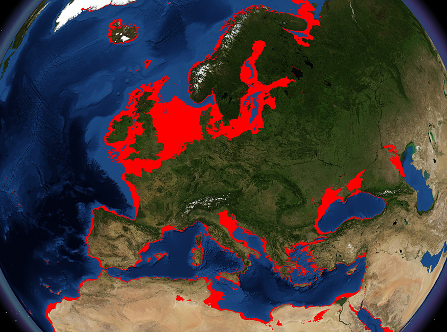
For most of human history on this planetabout 90 per cent of the timesea levels have been substantially lower than at present, exposing large tracts of territory for human settlement. Europe alone would have had a land area increased by 40 per cent at the maximum sea level regression (Figure 1). Although this has been recognised for many decades, archaeologists have resisted embracing its full implications, barely accepting that most evidence of Palaeolithic marine exploitation must by definition be invisible, believing that nothing has survived or can be found on the seabed, and preferring instead to emphasise the opportunities afforded by lower sea level for improved terrestrial dispersal across land bridges and narrowed sea channels.
Map of Europe and the Mediterranean, showing the extent of the continental shelf exposed at maximum sea level regression (shown in red) at the Last Glacial Maximum. Courtesy of Simon Fitch and Ben Geary, University of Birmingham. Image is derived from USGS NED and ETOPO2.

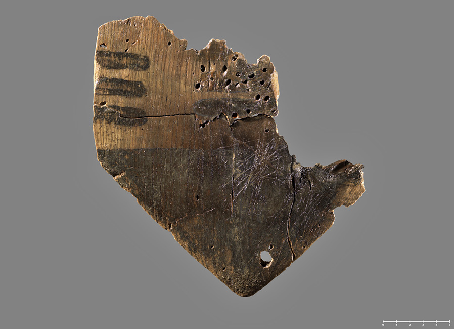
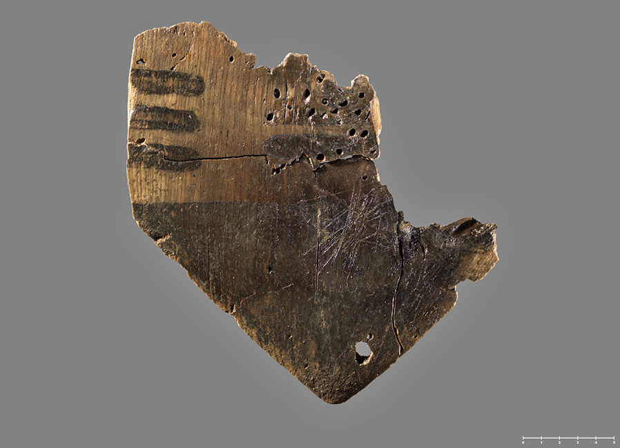
In the past decade, opinions have begun to change in response to a number of factors: evidence that marine exploitation and seafaring have a much deeper history in the Pleistocene than previously recognised; the steady accumulation of new underwater Stone Age sites and materials, amounting now to over 3000 in Europe, and often with unusual and spectacular conditions of preservation (Figure 2); availability of new technologies and research strategies for underwater exploration; and the growth of targeted underwater research (Reference ErlandsonErlandson 2001; Reference BaileyBailey & Milner 2002; Anderson et al. 2010; Benjamin et al. 2011).
Part of a wooden paddle from a submerged Ertebølle site off the island of Hjarnø in Horsens Bay, Denmark, showing detail of working and decoration. Scale in centimetres. Photograph by Derrick Butler, courtesy of Claus Skriver.
Above all, it has become ever clearer that coastal regions generally support larger concentrations of population than hinterlands, with greater ecological diversity, better groundwater supplies, more equable climatic conditions, more productive conditions for plant and animal life on land, and the availability of marine resources. Since most of the great transformations of world prehistory took place when the sea level was lower than at presentincluding the global dispersal of archaic and anatomically modern humans, the origins of fishing and seafaring, the origins and dispersal of early farming economies, and the roots of the earliest civilisations such as those of Mesopotamia and the Aegeanit follows that existing syntheses of world prehistory are likely to be seriously incomplete.
SPLASHCOS and Deukalion
These circumstances provide the stimulus for SPLASHCOS, a research network (20092013) funded by the European Union's COST scheme (Cooperation in Science and Technology) to coordinate and promote research on the underwater landscapes and archaeology of the continental shelf drowned by the sea level rise at the end of the Last Glacial. It began with a proposal in 2008 by Nic Flemming and Dimitris Sakellariou to convene a European group to seek funds for a large-scale international projectthe Deukalion Projectfrom the EU's Framework Programme. The complexities of such an undertaking led rapidly to an expansion of the network and the birth of SPLASHCOS.
COST Actions are inter-governmental coalitions, rather than centrally directed projects. Each participating government nominates two members to a Management Committee, which oversees a work programme set out in a publicly available Memorandum of Understanding, and which can recruit additional members for specific tasks. COST does not support salaried researchers or new primary research, but funds meetings to coordinate and plan new research, publications and training of early stage researchers.
SPLASHCOS is a trans-domain Action which has grown to include over 100 regular members from over 60 institutions in 26 European States, and a wider corresponding membership. It is inter-disciplinary as well as international, including archaeologists, cultural heritage managers and marine geoscientists. It has four Working Groups (WGs), concerned with coordinating existing knowledge and research planning on Submerged Archaeology (WG1), Submerged Landscapes, including the taphonomy of underwater preservation (WG2), Technology and Training (WG3) and Public Outreach and Commercial Collaboration (WG4). Meetings twice a year in different European centres promote the work of the Action, and the original Deukalion group continues to work within the SPLASHCOS framework on long-term strategy and funding.
Preliminary results
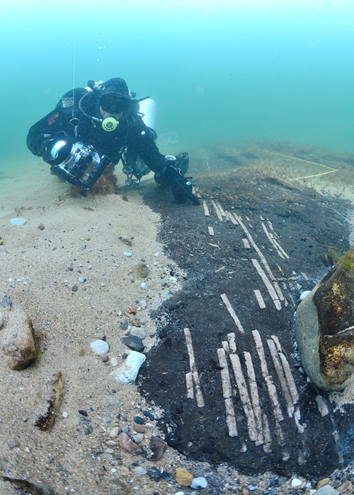
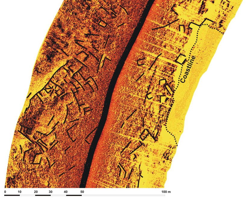
It is clear that new finds are being made in increasing numbers, not only in Denmark and Israel, where the earliest discoveries were pioneered (e.g. Galili et al. 1993; Reference FischerFischer 1995; Reference SkaarupSkaarup & Grøn 2004), but in all the major European sea basins, and these include not only sites and artefacts but reconstructions of submerged landscapes (Figures 35). As the evidence base expands, so new intellectual problems are coming into focus, such as the impact of sea level change on past human societies and the nature of their response.
Remains of a wooden fish trap exposed on the seabed at the site of Havang in southern Sweden. Photograph courtesy of Arne Sjöström.

Reconstructed street plan at the submerged Bronze Age town of Pavlopetri, Greece, based on sidescan acoustic survey. Image provided by Dimitris Sakellariou.

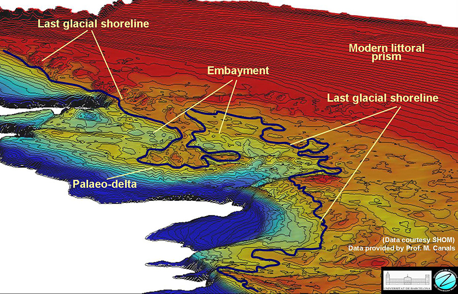
Reconstruction of the coastline of the Golfe du Lion on the Mediterranean coast of France at the Last Glacial Maximum, showing a river delta and other features. Courtesy of Miquel Canals.

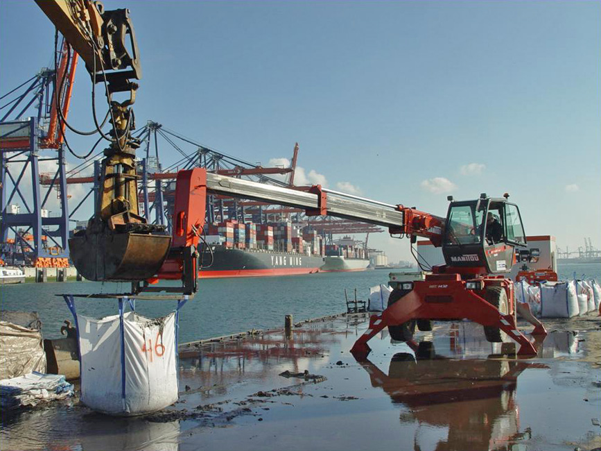
The involvement of geoscientists in the Action, who are familiar with the demands of offshore work, is stimulating new survey work using existing seismic, acoustic and coring techniques, remotely operated vehicles and submersibles and the development of new ones. The costs and difficulties of underwater research should not be underestimated. However, a variety of strategies are being employed to minimise these, including collaboration with scientists conducting offshore ecological and geological research, and with industrial companies engaged in trawler fishing, gravel extraction, oil and gas exploration, and construction of offshore windfarms and other industrial facilities (e.g. Gaffney et al. 2007, 2009; Tizzard et al. 2011; Hafeez et al. 2012; Weerts et al. 2012), work that has involved many tens of millions of Euros that would not otherwise have been available for archaeological research (68).
Excavations in progress in the Yangtze harbour in Rotterdam, Netherlands. The sediment grabber is located on a pontoon. It is specially designed to close horizontally, scrapes about 20cm of sediment off the surface, and deposits it in large bags whose entire contents are sieved on the quayside through a 10mm and 2mm mesh. Photograph by D.E.A. Schiltmans, courtesy of Port of Rotterdam and City of Rotterdam Archaeological Service.

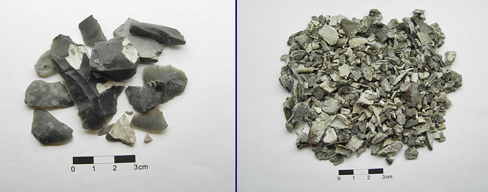
Examples of worked flints and bone fragments recovered from the Yangtze harbour in Rotterdam. Photograph by D.E.A. Schiltmans, courtesy of Port of Rotterdam and City of Rotterdam Archaeological Service.

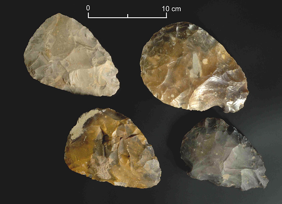
Group of Lower Palaeolithic handaxes recovered during gravel extraction from Area A240, 11km off the coast of eastern England in the North Sea. Subsequent acoustic survey and sediment sampling in the area of the handaxe finds has demonstrated the presence of channel fills including fine sediments and palaeoenvironmental data, showing that high resolution data can survive several cycles of inundation and exposure by sea level change. Photograph courtesy of Rijksmuseum van Oudheden (RMO)/National Museum of Antiquities, Leiden.

These examples also underline the policy-relevant nature of continental shelf research. Geoscientists are interested in making common cause with archaeologists in obtaining more precisely dated and located palaeoshorelines that feed into improved models of sea-level change and prediction; and commercial companies are increasingly bound by legislation to protect the underwater heritage and to undertake impact assessments and mitigation work.
SPLASHCOS itself has stimulated new national, bi-lateral and international projects with 14 million of funding, including underwater exploration, outreach work, and participation in pan-European initiatives to develop common standards of seabed mapping; a further 6 million was made available in 2011 to develop new technology for the investigation and management of submerged archaeology and the underwater heritage including Stone Age settlements. SPLASHCOS members have contributed to 14 international conferences during the past year, including dedicated sessions in 2012 in Brisbane, Australia, and Helsinki, Finland, both of which will be published (Fischer et al. in press; Harff et al. in prep.). The Action is also supporting edited publications summarising the work of WG1 and WG2 (Bailey et al. in prep.), a website with information on techniques and technology, and training schools for a new generation of archaeologists and geoscientists keen to explore this new discipline. The 2013 meetings include a workshop with the North Sea offshore industry in Esbjerg (1415 March) and the final conference of the Action, which will be open to all, at the University of Szczecin, Poland (2327 September).
Above all, SPLASHCOS is generating momentum in developing what is in effect a new discipline, drawing on the expertise of a wide range of specialists and a younger generation of enthusiasts to focus on the human dimension and relevance of the continental shelf, out of scientific and intellectual curiosity in its own right, as a contribution to work of high policy relevance to modern society, and as a topic that attracts wide public interest. Arguments that underwater research is not worth pursuing because the evidence has been destroyed, or is too difficult and expensive to recover, and that in any case the funding would be better invested in new research on land, still linger as the rearguard defence of an outdated archaeological mindset. This is rapidly being superseded by a new generation of research, and a growing body of new evidence and results.
Acknowledgements
SPLASHCOS is COST Action TD0902, and we thank COST (http://www.cost.eu) for funding and continued support of our activities. We thank all our members for their enthusiasm and hard work, our rapporteurs, Daniela Koleva (St Kliment Ohridski University of Sofia, Bulgaria) and Ipek Erzi (Scientific and Technological Research Council of Turkey, Tübitak) for their support and advice, and Cynthianne DeBono Spiteri the Grant Holder and Administrative Secretary of the Action for her unfailing patience in negotiating its financial and bureaucratic complexities. Members of the Management Committee are listed at http://www.cost.eu/domains_actions/isch/Actions/TD0902?management, and the full list of active members (including additional members of Working Groups and Early Stage Researchers) is on the SPLASHCOS website (http://www.splashcos.org/)
Collaborators
The following have played key roles in SPLASCHOS activities as organisers of major meetings (MM), Training Schools (TS), Chairs of Working Groups WG) and members of the Deukalion Planning Group (DPG).
Pablo Arias (DPG) Instituto Internacional de Investigaciones Prehistoricas de Cantabria, Universidad de Cantabria, Santander, Spain
Miquel Canals (TS) CRG Geociencies Marines, Facultat de Geologia, Universitat de Barcelona, Spain
Francesco Latino Chiocci (DPG and MM) Department of Earth Sciences, University of Rome "La Sapienza", Italy
Katerina Dellaporta (DPG) 2nd Ephorate of Byzantine Antiquities, Ministry of Culture, Athens, Greece
Justin Dix (DPG) and Nic Flemming (Founding Chairman of DPG) National Oceanography Centre, Southampton, UK
Anders Fischer (DPG and Chair of WG1) Heritage Agency of Denmark, Copenhagen, Denmark
Vince Gaffney (DPG) Institute of Archaeology and Antiquity, University of Birmingham, UK
Ehud Galili (TS) Israel Antiquities Authority, Atlit, Israel
Timmy Gambin (TS) Archaeology Centre, University of Malta, Malta
Ole Grøn (DPG) and Thijs Maarleveld (MM) Centre for Maritime and Regional Studies, University of Southern Denmark, Esbjerg, Denmark
Jostein Gundersen (DPG and Training Manager) Directorate for Cultural Heritage (Riksantikvaren), Oslo, Norway
Jan Harff (DPG and Chair of WG2) Leibniz-Institute for Baltic Sea Research, Rostock, Germany
Hauke Joens (DPG) Lower Saxony Institute for Historical Coastal Research, Wilhelmshaven, Germany
Gilles Lericolais (DPG) Direction for European and International Affairs, IFREMER, Issy-les-Moulineaux, France
Friedrich Lüth (DPG and MM) Deutsches Archäologisches Institut, Berlin, Germany
Tine Missiaen (Chair of WG3) Department of Geology and Soil Science, RCMG, Ghent University, Belgium
Garry Momber (DPG) and Julie Satchell (Chair of WG4) Hampshire and Wight Trust for Maritime Archaeology, National Oceanography Centre, Southampton, UK
Hans Peeters (DPG) Groningen Institute of Archaeology, Netherlands
Irena Radic Rossi (MM) University of Zadar, Croatia
Alar Rosentau (TS) Department of Geology, University of Tartu, Estonia
Henk Weerts (MM) Cultural Heritage Agency, Amersfoort, Netherlands
Andrzej Witkowski (MM) Faculty of Geosciences, University of Szczecin, Poland