

In the early seventh century, Sui dynasty emperor Yangdi dispatched two overseas missions to investigate a rumored land. Sailing east from the southern Chinese coast, the explorers made brief contact and recorded the name of the land as Liuqiu 流求 and the people that inhabited it “Liuqiu people” (流求人). Over the next 700 years Chinese records made scattered references to Liuqiu as a distant land in the sea east of China. Then, in the late fourteenth century, the Ming dynasty established official relations and received regular tribute by the Liuqiu kingdom (琉球國). Generations of Chinese authors in the Ming and Qing understood the geographical position of this land to correspond to the Ryūkyū kingdom, within what is today’s Okinawa prefecture, Japan. Indeed, Ryūkyū is the Japanese pronunciation of the Chinese characters Liuqiu.Footnote 1
This understanding suddenly shifted in the twentieth century. In 1919, a new official Chinese dynastic history associated the textual toponym Liuqiu with the geographical space of Taiwan. Reflecting on the Sui historical record and early maritime history the editor Ke Shaomin 柯劭忞 wrote, “The historian [i.e. Ke, referring to himself] says that this Liuqiu is today’s Taiwan. Today’s Ryūkyū had contact with China beginning in the Ming.”Footnote 2 Rejecting centuries of uncontested records and geographical knowledge, Ke wrote into Chinese history an entirely novel reading: the Liuqiu of the Sui referred to Taiwan and not Ryūkyū. This statement quickly became the accepted interpretation and stands as what I call the Liuqiu–Taiwan thesis. Much subsequent work on Taiwan or Chinese maritime history up to the present day has repeated the rendering.Footnote 3 The voluminous scholarly works on Taiwan’s modern political history and cross-Strait relations also repeat the Liuqiu–Taiwan thesis to reference the origins of Taiwan.Footnote 4 The Chinese Communist Party elevated the thesis to an overt political position in its 1993 White Paper on Taiwan, and subsequent pronouncements (including speeches from the Party’s highest officials) have continued to use this historical interpretation to claim sovereignty over Taiwan.Footnote 5
How did this happen? How did an unalloyed understanding of Chinese history, evidenced in the records of Chinese cartographers, explorers, seafarers, merchants, diplomats, scholars, and even court historians become something other than it always had been? How did the history of China and Taiwan get rewritten to turn references of Liuqiu from the space of Ryūkyū to the place of Taiwan?Footnote 6 The unpacking of this puzzle reveals incongruent pieces spread across the modern world as European and Asian actors engaged in producing and transmitting new knowledge on the origins of Taiwan. The following pages show that the Liuqiu–Taiwan thesis began with a French Sinologist in 1874 and was quickly disseminated throughout Europe. Japanese scholars adopted the thesis shortly after Japan’s annexation of Taiwan in 1895 and further developed it as imperial knowledge. Influenced by Japanese Sinologists, Chinese scholars took up the thesis in defining China’s historical borders in the Republic of China. By the second decade of the twentieth century, the Liuqiu–Taiwan thesis was so well circulated and accepted that it had become the standard interpretation.
Given the widespread employment of the thesis it is not surprising that contemporary scholars have taken a critical interest. While some have outlined the transnational historiography, the bulk of scholarly efforts are reserved for investigations on the veracity of the claims to determine if the Liuqiu referenced in the Sui was actually Taiwan or not. In this latter endeavor some have worked to further validate the thesis and show that Liuqiu was indeed Taiwan, while others have spared no effort in re-examining the quoted texts and uncovering new evidence to find fault in the thesis and to return the understanding of Sui Liuqiu to what it was before the late nineteenth century, Ryūkyū. Often these sides talk past each other to arrive no closer at a common understanding of the matter. Here truth seems to elude historical inquiry.Footnote 7
To date, however, little work has been done on the emergence, transmission, and proliferation of the Liuqiu–Taiwan thesis itself. While historians are not unaware of the actors in Europe, Japan, Taiwan, and China that developed and pushed the thesis, how this piece of knowledge was produced and passed on remains unexplored and thus unexplained.Footnote 8 Indeed, why was the claim made in the first place and how was it transmitted around the world to become not just widely accepted but the standard interpretation on the matter? The most astonishing thing about the initial thesis was that it disregarded centuries of Chinese records and writings on the matter. Latter scholars flushed it out, to be sure, and worked in textual evidence for Liuqiu as Taiwan, but why did they take up the claims at all? Why choose to devote intellectual energies to such a thesis, and a rather obscure one at that? This is all the more puzzling given that throughout Chinese history references to Liuqiu were unambiguous and uncontested; yet modern scholars largely ignored their Chinese predecessors.
This article begins from the premise that Ming and Qing scholars were not wrong in their understanding of Liuqiu as Ryūkyū. I do not dwell there, however, for my inquiry is not whether the historic Liuqiu was or was not Taiwan, but rather why the claim was first made and then unquestionably and uncritically taken up by scholars in Europe, Japan, Taiwan, and China: I am less concerned with what is the “truth” and proving it to be so, and more with how a particular truth-claim was produced. I ask not about the evidence of a particular claim—for others seem to have exhausted this line of inquiry—but rather about the social and political contexts that the particular claim was circulated and validated.Footnote 9 How was it that Ke Shaomin could uncritically and without evidence or argument write in his official history of China that Liuqiu was Taiwan?
The following pages argue that the thesis was produced and transmitted as new knowledge through the work of three separate but interrelated forces: scientific methodology, imperialism, and nationalism.Footnote 10 Methodologically, an emergent “scientific” inquiry rooted in the European Enlightenment guided a new generation of Sinologists to produce knowledge in a particular language formulation; the practice was appropriated by modern Asian actors over their own traditions. Simultaneously, political actors began to draw boundaries and organize the world in terms of national territory. The intensification of competition among expanding and emerging powers sparked inquiry into political borders, which led scholars, nationalists, and administrators to produce territorial claims. In East Asia, European powers carved out interests and an emergent Japan asserted itself both regionally and internationally. Chinese nationalists, meanwhile, sought to determine the territorial jurisdiction of the Republic of China and the historical areas of Chinese civilization. What the Liuqiu–Taiwan thesis did for actors in this context was help transform the ambiguous territorial governance of the Qing empire into the modern borders of the Chinese nation.
Telling the story of how Taiwan came onto the modern Chinese map furthers an understanding of how the modern Chinese nation was formed. In recent decades, scholars have shown that the contemporary borders of the Chinese nation-state are not timeless, as often held, but rather a late invention. Manchu rule and Qing territorial expansion and incorporation of non-Han peoples forced the question of the nation on late nineteenth- and early twentieth-century Chinese revolutionaries: Would frontier regions like Xinjiang and Tibet be considered part of a Chinese republic, and if so would non-Han ethnicities be considered Chinese? Republicans settled on the most inclusive definition of the Chinese nation and people, incorporating nearly all territory and ethnicities claimed by the Qing (even nominally) in their Chinese state, and drawing the borders of the Republic of China as large and encompassing as possible.Footnote 11 The Chinese Communist Party, by contrast, initially encouraged the liberation and self-determination of peoples of the Qing borderlands and the creation of independent communist parties and republics. By the time of the Chinese Communist revolution in 1949, however, the CCP position had shifted closer to that of the Republicans, and in the 1950s the People’s Liberation Army occupied the frontier regions, assuring that nearly all of the territory of the former Qing empire was under PRC control.Footnote 12
Although Taiwan was equally ambiguous territorially, it was not part of Chinese nationalists’ immediate concerns and has not attracted the same scholarly attention. The island came under Qing jurisdiction in 1683 but emperors were constantly wary to devote administrative resources to governing and taxing the migrant population. In fact, Qing policy constantly vacillated between allowing migration with the opening new land and banning it outright. Over the course of the eighteenth and nineteenth centuries, parts of the island gradually came under direct Qing control as increasing migration and population growth challenged governance. In 1885, Taiwan as a whole was designated a province with an appointed provincial governor who undertook administrative and infrastructure projects. The ceding of Taiwan to Japan in 1895, however, relieved late-nineteenth century revolutionaries and nationalists of the question of where and how the Taiwan frontier fit on the map of the Chinese nation. Indeed, Taiwan had become part of the Japanese empire.Footnote 13
The question of Taiwan did not disappear, of course. Early twentieth-century Chinese thinkers and nationalists—especially those Chinese living on Taiwan under Japanese rule—grappled with Taiwan’s history and how to define it on the new Chinese map. As the following pages show, those debates often revolved around the Liuqiu–Taiwan thesis and situated Taiwan historically and geographically within the Chinese nation, even if the island had been ceded in perpetuity. Although Taiwan as a Chinese frontier was less relevant for a revolutionary like Sun Yat-sen, who was more concerned with the land and ethnicities of the northern and western regions of the Qing empire, Taiwan was part of a larger national question for Ke Shaomin, and one of dire immediacy for Lian Heng 連橫 and other Chinese nationalists on Taiwan. Through their efforts—as part of a final chapter of the convoluted story of the Liuqiu–Taiwan thesis—Taiwan was written into the Chinese nation.
Taiwan’s pre-history and the Liuqiu–China maritime route in Chinese records
Prior to an 1874 French article, no one in any language had ever made such a direct association of Taiwan with the historical Liuqiu.Footnote 14 For most Qing authors, Taiwan lacked a pre-history: it was a distant land that lay beyond the pale, inhabited by head-hunting savages without written language. They found no prior records about Taiwan, and found China had no contact with the land or people. The historical Liuqiu, by contrast, appeared numerous times in the Chinese records, from as early as the Sui and continuously through the Qing. Geographers, seafarers, ambassadors, and literati knew of Liuqiu and often traveled there by way of maritime markers—other islands in the sea used to guide sailors. Centuries of recordings of the maritime route from China to Liuqiu-cum-Ryūkyū offers the most convincing case that the Liuqiu of the pre-Ming texts refers to Ryūkyū and not Taiwan.
Taiwan’s pre-history in Qing writings
The name Taiwan appears relatively late in the Chinese historical record. Ocean currents and local headhunting practices kept Chinese seafarers from early contact with Taiwan. Only after official relations with the Ryūkyūs had been established in the Ming did Chinese boats make sightings of Taiwan. In the early fifteenth century some ships of maritime explorer Zheng He’s fleet got blown off course and supposedly came to rest in the bays of Taiwan. Because the captain thought himself near the Ryūkyūs (i.e. Liuqiu) he called the place Xiao Liuqiu 小琉球, or little Ryūkyū.Footnote 15 Taiwan was thus often referred to as Xiao Liuqiu through the end of the Ming. In the seventeenth century, as the Chinese population increased on the island, Fujian migrants began to refer to their new home as either dayuan 大圓/大員 (great round) or mai-yuan 埋怨 (unjust death), pronounced daiwan in southern dialect, which was picked up by the Dutch during their brief colonial project on the island. The Qing transcribed it as Taiwan 臺灣.Footnote 16
Qing writings about Taiwan nearly always portrayed the island with an unknown past. The typical explanation by Qing officials or literati writing about Taiwan’s history was that it was a foreign land in the eastern sea that was occupied by the Dutch in the late Ming and then the Zheng regime before being pacified by Kangxi. Prior to these developments, authors noted, Taiwan had little contact with China: it was wilderness, situated on the outermost periphery of the known world.Footnote 17 “Previous generations had no contact with China, nor did the Chinese even know of this place,” wrote Literatus Yu Yonghe 郁永和 in his late seventeenth-century account of Taiwan. “All of the maps and references speak of barbarian places but never mention Taiwan.”Footnote 18 Similarly, the eighteenth-century Zhuluo county gazetteer (諸羅縣志) noted, “Zhuluo county was formerly called Taiwan. It is a desolate frontier far off in the sea that no one knew about.”Footnote 19 Even the official geographical text of the Qing empire, the Da Qing yitongzhi 大清一統志, which provides detailed descriptions and histories of every province and prefecture, emphasized these points: “Since ancient times it was a far-off land and had no contact with China.” The entry goes on to begin its recount of known history with Dutch and Zheng occupations before Kangxi established Taiwan Fu in 1684.Footnote 20 An abridged version compiled a half century later said simply, Taiwan was “originally a barbarian land to the east.”Footnote 21
The Liuqiu–China maritime route in Chinese records
No Qing texts or writings associate Taiwan with Liuqiu. Indeed, Qing authors do not even mention Liuqiu when writing about Taiwan. This is because Qing actors understood Liuqiu as Ryūkyū. For over a millennium, from at least the seventh century through the eighteenth, Chinese merchants and seafarers sailed to and from a place they called Liuqiu. They established a well-traveled maritime route, marked by other islands in the sea to guide them to their destination. This route provides the most convincing indication of the geographical location of the historical Liuqiu. With at least forty-eight written references and four maps extant in Chinese texts across centuries in sources as diverse as the official Yuan history to the writings of envoys and ambassadors in the Ming and Qing, recordings of the Liuqiu maritime route show the same route being traveled throughout time.Footnote 22 As one modern-day scholar of Chinese maritime history puts it, “From the seventh century through the seventeenth, the Ryūkyū-China maritime route was well established. The Ming used this route as did the Sui.”Footnote 23 Through an examination of these records it becomes clear that the same route took travelers to Liuqiu in the Sui and to Ryūkyū in the Ming.Footnote 24
The earliest written references to Liuqiu appear in records from China’s middle period and recount an established maritime route. The dynastic history of the Sui, published in 636, records, “The country of Liuqiu is set in the sea surrounded by islands. It is reached by sailing east for five days from Fuzhou … first to Gaohuayu islet [高花嶼], then east another two days to Jubiyu islet [䵶鼊嶼], then another day to arrive at Liuqiu [流求].”Footnote 25 The mention of these islets serves as maritime route markers and were descriptively named—they were small points of land or rocks protruding from the sea pointing sailors on their way to a destination.Footnote 26 Similarly, the dynastic history of the Tang, composed nearly three centuries later notes a similar route: “From [Quan]zhou, travel directly east on the sea two days to Gaohuayu; another two days to Jubiyu; another day to Liuqiu-guo.”Footnote 27
This route continued to be used throughout the Song and Yuan. At least three original, non-copied references and one map from the Song note this maritime route, as does at least one reference and one map from the Yuan.Footnote 28 An early twelfth-century text, for example, says this about the Liuqiu maritime route: “Sailing east on a junk from Quanzhou 130 li into the sea, without terrible wind or great waves one will reach Gaohuayu in two days … another two days to reach Jubiyu, which is shaped like a tortoise shell. Another day to arrive at Liuqiu-guo. This country has accommodations near the sea for Chinese travelers.”Footnote 29 Likewise, Southern Song literatus Zhu Mu 祝穆 wrote at length about Fujian and maritime routes, noting the same markers enroute to Liuqiu.Footnote 30 This route is also visually depicted on the Northern Song map, Tangshidao tu 唐十道圖 (see Figure 1).
Tang shidao tu 唐十道圖 from the eleventh century. The Liuqiu maritime route is marked in the bottom right corner with Gaohuayu, Jubiyu, and Liuqiu in tandem to the east.

By the late imperial period the maritime route had been well established with consistent reference to the islet-markers guiding travelers to Liuqiu. The route was the same route that sailors and embassies in the Ming and Qing traveled. In 1372 the Ming court established official relations with Liuqiu, changing the written characters from the cruder water radical 流求 to the more literary jade radical 琉球, or Ryūkyū in Japanese. The Ming sent an ambassador to the islands, educated Ryūkyūan students in the Chinese classics, and received a Ryūkyūan mission in the Ming court every two years.Footnote 31 At least seventeen references from Ming and Qing records discuss the route from China to the Ryūkyūs, all of which chart Gaohuayu and Jubiyu enroute to Liuqiu.Footnote 32 For example, Ming ambassador Chen Kan 陳侃 wrote about traveling back from the islands to China in 1534, noting, “Jubiyu is to the west one day, Gaohuayu is to the west three days.”Footnote 33 Two decades later Zheng Ruozeng 鄭若曾 produced a map with the Ryūkyūs in the center and Jubiyu and Gaohuayu in tandem to the west (Figure 2). Jubiyu is marked on the map as “one day’s journey” from Liuqiu and Gaohuayu “three day’s journey.” Taiwan sits in the bottom left corner.Footnote 34
Liuqiu-guo tu 琉球國圖 from the mid-sixteenth century showing the maritime routes and distances traveling out of Liuqiu, or the Ryūkyūs. Liuqiu is in the center of the map; Gaohuayu and Jubiyu extend off to the upper left. Taiwan is labeled as Xiao Liuqiu in the bottom left. Zheng Ruozeng, Zheng kaiyang zazhu, liuqiu-guo-tu, juan 7:1.

From both maritime navigational records and contemporary Qing geographical writings it appears that Chinese chroniclers understood Liuqiu as the Ryūkyūs and distinguished it from Taiwan. Early records show an established maritime route that ran from southern China to Liuqiu by way of two stable route markers, Gaohuayu and Jubiyu; this same maritime route was used since at least the Sui and continued through the Qing. Qing authors likewise understood Chinese contact with Taiwan to be very recent. In short, Chinese writings spread over a millennium express an understanding of the historical Liuqiu as the Ryūkyūs and China to have had no contact with Taiwan prior to the Ming.
D’Hervey de Saint-Denys and the origins of the Liuqiu–Taiwan thesis
If generations of scholars and chroniclers had no doubt about the identity of Liuqiu, how and why did their modern heirs shift the association from Ryūkyū to Taiwan? This section locates the origins of the Liuqiu–Taiwan thesis in an 1874 article by the French Sinologist Leon d’Hervey Saint-Denys.Footnote 35 D’Hervey’s thesis was foremost the product of an emergent methodology of the Enlightenment that was quickly transforming Sinology from textual quotation to scientific analysis. Rejecting the work of previous scholars on maritime history and looking beyond the conclusions of traditional texts, d’Hervey initiated a new inquiry into the origins of Taiwan. This inquiry, while born from a particular methodological language, was also as part of the political context of Western penetration into East Asia and the move to assign sovereignty to Taiwan. D’Hervey’s research worked to attach Taiwan to China historically. He argued that contrary to the traditional Chinese assumption that Taiwan lacked a history, Taiwan was known historically not as Taiwan but as Liuqiu. “The discovery of a rather curious geographic mistake,” he said, refuted the common knowledge of the day and of centuries past.Footnote 36
In the August–September 1874 issue of Journal asiatique, d’Hervey published his “discovery.” The drive of the article was to investigate what the Chinese called Taiwan prior to calling it Taiwan; he relied on deduction to focus his inquiry, and projecting a tone of scientific objectivity, placed himself as a disinterested inquirer in relation to the received wisdom of the matter. “When encountering a fact that appears in formal contradiction with all that is commonly seen,” he began, “whether in history or any other branch of human knowledge, one would not go as far as to reject it a priori as an error. Still, one feels distrust, which leads to giving it special attention so as not to accept it without close examination.”Footnote 37 The contradiction of fact was the lack of Taiwan in the historical record, which seemed impossible to d’Hervey, for records show “Chinese vessels furrowing the Japanese and Chinese seas in the first centuries of our era.” Citing Han Wudi’s maritime attack on Korea in the first century BCE, d’Hervey asked, “Do these facts make it possible to believe, as several authors do, that until the year 1430 the existence of Formosa was unknown to the Chinese?”Footnote 38
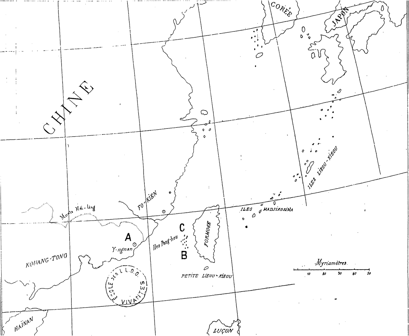
For d’Hervey it did not, and he built his argument on a close reading of a single Yuan dynasty text, which he mistakenly believed to contain the earliest references to Liuqiu. The text, Ma Duanlin’s 馬端臨 Wenxian tongkao 文獻通考, is an administrative history of known governments and political activity from antiquity to the Southern Song, and contains among other things chapters on geography, most of which were copied from earlier sources. “To my eyes,” d’Hervey wrote, “the question should limit itself to discover what name Ma-touan-lin called Formosa.”Footnote 39 He believed that by posing this question he could show that the Liuqiu mentioned in Ma’s history referred to Taiwan, “its actual name, which is of much posterior origin from the time of Ma.”Footnote 40 Drawing on the text’s Liuqiu chapter d’Hervey recreated the journey of the Sui mission and argued that it led to Taiwan, not the Ryūkyūs. Charting the five-day course of the Sui mission from Fujian to Gaohuayu and Jubiyu islets and then Liuqiu, D’Hervey claimed that the islets were part of the Penghu cluster and that it would be impossible to travel from Penghu to Ryūkyūs in a day, making it “completely clear that Formosa is the only ground on which the Chinese could have landed” (see Figure 3).Footnote 41
d’Hervey’s map used to illustrate his thesis on the Liuqiu–Taiwan connection. He hypothesized that the Sui dynasty exploration party departed from Yian (point A) and then got lost in the Penghu islands. Points B and C he claimed are Gaohuayu and Jubiyu, respectively. D’Hervey de Saint-Denys, “Sur Formose,” 108–9.

D’Hervey’s article is short, around a thousand words, and works quickly in methodological precision towards the conclusion contained in the inquiry, i.e. the name of Taiwan before it was called Taiwan. He attacked some of his European Sinological predecessors on their Liuqiu positions while drawing on others to make supportive claims. Throughout, he seems convinced of his starting assumption, namely Chinese seafaring prowess certainly took them to Taiwan. The proof of Gaohuayu and Jubiyu as part of Penghu, for example, is pinned upon an islet in Penghu known as Huayu 花嶼 (Flower islet) and a mound on the northern tip of the largest Penghu island called Guibishan 龜壁山/奎壁山 (Turtle wall hill); both bear similar names to those of the Sui maritime markers but are at opposite ends of the Penghu chain and did not serve as route markers.Footnote 42 Indeed, the conclusion of Liuqiu as Taiwan appears to weigh heavy in d’Hervey’s approach and analysis, both methodologically and geographically.
D’Hevery’s interest in Liuqiu as Taiwan was driven by both institutional and geopolitical matters. By the time he published on Liuqiu d’Hervey had ascended to the highest post in Sinology, the Chaire de Langue et Litterature Chinoise et Tartar-Mandchoue at the College de France.Footnote 43 He was only the third person to hold the chair, which was created in 1814 as European interest in China grew, and he succeeded his esteemed professor Stanislas Julien, who had translated key Chinese texts and laid the groundwork for teaching Chinese grammar.Footnote 44 Continuing this tradition, d’Hervey published widely over his lifetime, some sixteen books in all covering topics as diverse as Confucius, Tang poetry, Yuan history, Ming and Qing literature, an encyclopedia, and Chinese agriculture.Footnote 45
Such a background was not unusual for a nineteenth-century French Sinologist, for the position championed positivist inquiry and scientific methodology, not Chinese learning or experience. The eminent Stanislas Julien, for example, while he read and translated Chinese texts, did not speak the language, nor did he travel to China. The learning and academic authority of the China scholar was not in his access to China but rather in what fellow Sinologist Henri Cordier termed “scientific training.” This training, according to contemporaries, was to take place in European academies and include practices of inquiry, analysis, and understanding framed by the Enlightenment.Footnote 46 In practice this meant a turn from simple textual study and reproduction to one of comparative analysis and historical development. Although the new generation of Sinologist benefited from the writings and collections of those with direct access to China and Chinese texts, such as the Jesuits or other missionaries in China, their aims were not to understand the particularities of China and penetrate society, but rather to grasp a universalism of human civilizations.Footnote 47 In fact, the new generation of Sinologists consciously rejected religion in favor of reason and scientific inquiry.Footnote 48
At times there was a cleavage between what contemporaries called the “sinologists de chambre” and the “practical sinologist in China.”Footnote 49 The former, such as d’Hervey, saw the latter as little more than interpreters, and the latter, often represented by the Jesuits, accused the former of lacking any real understanding of China. In d’Hervey’s case it played out openly. On multiple occasions the practical Sinologists accused him of not knowing anything about China; when he was nominated for the Sinological chair the Jesuit Paul Perny waged a bitter campaign to discredit him. Having spent many years in China, Perny felt that d’Hervey knew little of the language and could not have translated the books he had claimed. Perny further circulated a pamphlet through the streets of Paris accusing d’Hervey of being a “charlatan” who was “absolutely incapable of speaking, writing or translating six lines of Chinese.” D’Hervey filed a libel lawsuit and eventually won, sending Perny to jail for six months plus a fine of 5,000 francs.Footnote 50
D’Hervey kept his attacks academic, criticizing the assumptions and methods of his predecessors and contemporaries. In his Liuqiu article he emphasized the “geographical mistakes” and “double errors” of other scholars, and then went on to dismiss the Chinese as well, noting, “The Chinese historians created the mistake [of Liuqiu] themselves.” This mistake, he said was perpetuated by missionaries, who blindly follow their Chinese guides and texts.Footnote 51 He did not stop there in his criticism of previous interpretations of Liuqiu, but took direct aim at anyone who understood Liuqiu as Ryūkyū or confirmed the reigning version of Taiwan’s prehistory. He went after German Sinologist Heinrich Julius Klaproth, for example, who had held university posts and was an early editor of Journal asiatique, the very journal in which d’Hervey was publishing.Footnote 52 D’Hervey took aim at Klaproth’s work on Taiwan, challenging the claim that Taiwan was historically isolated from China. “Klaproth’s double error must be pointed out,” d’Hervey wrote. “He is misled by the name Lieou-kieou and supposes that the expedition of 606 [actually 607] had visited these islands … In reality it was Formosa.”Footnote 53
Still, methodological contests among Sinologists do not explain interest in the historical origins of Taiwan. While a search for origins of civilizations and languages transfixed European scholars in this age, Taiwan did not fit into the grand narratives being built of Egypt, India, and the roots of the Aryan race—it did not even implicate China. So why the attention on Taiwan?
Geopolitical factors focused Europeans’ attention on Taiwan. After the opening of two ports on Taiwan in the wake of the second Opium War of 1856–1860, European powers increasingly eyed the island as a potential colony, though they failed to take any real steps toward realizing occupation.Footnote 54 Japan moved first, and moved aggressively in the early 1870s. On the grounds of redressing the deaths of Ryūkyūan sailors at the hands of indigenous peoples, Tokyo sent marines and a colonizing party to the island. Beijing protested but Tokyo raised the question of China’s sovereignty over Taiwan, claiming that the island lay outside of Chinese jurisdiction and was open territory. The two sides nearly went to war, diverted partly through the mediation of British diplomat and Sinologist Thomas Wade, who argued that European trade benefited with Taiwan under the political control of China and not Japan.Footnote 55 Wade helped negotiate an agreement between Japan and China, whereby both sides agreed that Taiwan belonged to China—although the question of Ryūkyūan sovereignty was shelved. That was in 1874, the same year d’Hervey published his Liuqiu–Taiwan thesis.Footnote 56
It would be a stretch to say that European colonial aims in China drove d’Hervey’s scholarship; rather these events point towards the emergence of questions about Taiwan and inquiries over its historical origins. European commercial interest in China and Taiwan, threatened by Japanese imperial ambitions, had suddenly raised the question of Taiwan’s sovereignty, and d’Hervey applied new methodological tools to propose one type of answer. The association of Taiwan with China was an answer that other European Sinologists would embrace, and it came to serve as the academic foundation for modern knowledge about Liuqiu and Taiwan. As d’Hervey put it: “The importance of Formosa and that of its geographical position seemed to me worthy of some attention … with a particular interest in the identification of nationality and search for origins.”Footnote 57
Territoriality and the proliferation of the thesis in European Sinology
As Western political and economic penetration of China intensified in the late nineteenth century, modern conceptions of sovereign places displaced earlier conceptions of space.Footnote 58 In this emergent ideology of territoriality, actors divided and ordered the globe into bound nation states with defined borders possessed of hard lines demarcating where one nation’s territory ended and another’s began. Maps were drawn, border markers laid, and wars fought to establish territorial definitions of the nation and construct a place out of the space for the control of public and political life.Footnote 59 No room existed for ambiguous boundaries and fluid lines of jurisdiction, as frequently found in premodern relation among states and empires (see Figure 4). Borders could no longer be sprawling zones but had to be marked with a clear line.Footnote 60
An eighteenth-century Chinese map of the world reflecting a cosmology that did not divide the world into sovereign nations with territorial borders. Here space was mapped according to geographic features and administrative practices. Qianlong tianxia yuditu 乾隆天下輿地圖 (1743, https://openmuseum.tw/muse/digi_object/eea242e64075ecf5fbe10240ca8dd389).

Western actors and their Meiji Japan disciples worked to conceive East Asia and the world in this way. In the course of doing so they had to make sense of the geographical space of Taiwan as a political place. This involved drawing lines around the Taiwan island in a way that the Chinese had not done—it involved viewing Taiwan in a way that was foreign to Chinese actors. These viewpoints were brought to a head in the early 1870s with interpretations of legal and sovereign jurisdictions over parts of the island and would continue to inform European inquiries and arguments about Taiwan, further proliferating the Liuqiu–Taiwan thesis.
The Chinese view
Qing actors saw Taiwan as a frontier without clear political demarcations. This is to say, the political place of Taiwan was viewed not as a bounded whole—an island defined by the physical borders of the sea—but rather as pockets of administrative control and cultural influence. Historically, Qing officials and writers understood Taiwan to have been outside the realm of Chinese cultural and political influence and to reside on the very outer edge of the Chinese cosmological space. It sat, for them, at the periphery of the world.Footnote 61 Even the late seventeenth century literatus Yu Yonghe, who was sympathetic to the incorporation of Taiwan and native peoples into the Qing, expressed bewilderment over the place. “We cannot really say whether Taiwan belongs to the Ryūkyū [archipeligo] or not,” he wrote in his travelogue. Continuing he noted it was a distant place beyond the cultural and historical influences of China. “The aborigines of Taiwan are savages who do not speak the Chinese language,” he declared, “they have no written script and cannot record the events of past generations.”Footnote 62 In the same manner, Liu-shi-qi 六十七, an eighteenth century official on Taiwan wrote, “In ancient times civilization did not reach this primitive and wild area.”Footnote 63
Ming and Qing officials and writers spoke of places rather than the island as a whole. In doing so, their references pointed to either geographical places as customarily defined or areas under administrative control: they evinced particular areas, usually harbors visited.Footnote 64 Likewise, official works of geography and administration in the Qing referred not to Taiwan as a geographical island, but rather to the administrative regions of the Qing. The Zhuluo county gazetteer, for example, notes that the county used to be called Taiwan and the island itself had no name.Footnote 65 Likewise, the Qing comprehensive geographical gazetteer Da Qing yitongzhi discusses Taiwan Fu, the administrative unit on the island, but not Taiwan as an entire political or geographical unit.Footnote 66 Not until the inclusion of Taiwan in the Treaty of Tianjin in the mid nineteenth century were the Qing forced to begin to reference the island as a whole, sparking a conflict of worldviews over territorial governance and jurisdiction, and forcing a reckoning of just what sovereignty and territorial control meant. By the 1880s, Qing actors recognized the natural boundaries of the island as politically equivalent and turned the entire Taiwan island into a provincial administrative unit. A provincial governor of Taiwan was also appointed.
Pre nineteenth-century Qing actors did draw borders, to be sure, although they were frequently charted by administrative considerations rather than international politics. In the early eighteenth century, Qing administrators on Taiwan ordered a boundary to distinguish and separate areas outside of Chinese cultural and political control. “From the north route to the south route,” decreed the Governor-general, “we must build a great wall and a deep trench as a permanent boundary.” This border was to have a 10 li buffer that served a threefold intent: to keep bandits from escaping, keep out native populations, and keep settlers from entering the frontier areas.Footnote 67 Although the border was drawn and marked with stelae, it was constantly challenged by Chinese settlers, who pushed farther into the frontier in search of land and natural resources. Likewise, Qing maps offered depictions of the Taiwan space with physical boundaries administratively defined often representing Taiwan from the perspective of Fujian, whereby a gaze was cast only on the western coast (see Figure 5). The mountain range drew a horizon line and ended the perspective of the map. This border of mountain peaks “stands like a screen,” according to the Fujian haifang zhi 福建海防志. “It is the outer boundary for China’s four [coastal] provinces.”Footnote 68
An eighteenth-century Qing map of Taiwan. The perspective of the map is from the Chinese mainland and only depicts the western coast of the island, where Chinese presence was confined. From Chen Lunjiong 陳倫炯, Haiguo wenjian lu 海國聞見錄 (1730).

The conflict
Modern European actors, by contrast, saw Taiwan as a place. They understood the ocean as borders, which encased a territory and gave it singular identity. From this physical formation, the logic went, political identity could then be assigned. Here Taiwan was viewed as a geographically bound island, not a frontier, and from that geographical view the place deserved sovereignty, which might be asserted by the population or assigned by an outside power. In short, to Japanese and Western observers, the island of Taiwan was conceived of as an integral geographic unit, where one state should have sovereignty over the whole island. By contrast, the Qing understood different parts of Taiwan to hold different jurisdictional statuses: the western plain and some other regions were directly-ruled Qing territory; other parts of the island were perceived to have a much looser connection to the Qing state.
The contrasting views of Taiwan and its sovereignty generated diplomatic misunderstanding and conflict. In the early 1870s when shipwrecked Japanese sailors were beheaded by indigenous peoples in the far south of Taiwan, the Meiji government demanded restitution. As noted above, the Qing demurred, saying that the event took place outside the administrative jurisdiction of the Qing and thus was not their responsibility. Anticipating such a response, Japan quickly dispatched a military expedition to Taiwan ostensibly to punish the perpetrators, but “its real object,” according to a Japanese advisor, “will be the annexation of [Taiwan].”Footnote 69 At stake was the exercise of sovereignty over certain portions of territory, which were then extrapolated to a geographical whole. For the Qing, Taiwan was those areas under its administrative control; for Japan and the international community, the island as a whole was the territory.
European actors took both political and historical interest in the situation. Politically, Europe wanted to avert war between Japan and China in order keep Taiwan under Qing control. Doing so would ensure that Taiwan remained subject to European treaties and allow continued European access to the island’s resources and markets. Historically, the question of Taiwan was raised, both its sovereignty and its origins. Enter d’Hervey and European Sinology. Through this double interest, the Qing were forced to commit to recognizing the Taiwan island as a territory, not a shifting frontier, and Taiwan was assigned an origin, becoming situated in China’s historical records.
The thesis proliferated
Stimulated by these events and evolving questions of sovereignty, European Sinologists quickly took to d’Hervey’s thesis. They began citing it widely and further developing it in greater detail, drawing on the simple outline that d’Hervey presented. By the end of the nineteenth century, the Liuqiu–Taiwan connection had spread throughout the historiography and was well established in the European consciousness. As Sinologist and French diplomat Camille Imbault-Huart put it, “One of our most distinguished scholars, M. d’hervey de Saint-Denys, superabundantly proved that the Chinese formerly gave Formosa the name of Lieou-kieou.”Footnote 70
Just a few years after Imbault-Huart, the Dutch Sinologist Gustaaf Schlegel picked up the thesis and expanded it. In doing so he presented arguments that came to be more widely cited than those of his French predecessor. As a member of the new generation of Sinologists that harnessed both scientific training in Europe and experience in China, Schlegel spent time in China, served the Dutch colonial government in Asia, and wrote extensively on Chinese secret societies.Footnote 71 In 1877 he became the first chair of the newly created Chinese language and literature department at Leiden University, and in 1890 co-established with French Sinologist Henri Cordier the academic journal T’oung Pao, which still circulates today. He further compiled a Dutch–Amoy dictionary and wrote on Chinese games, prostitution, astronomy, and comparative linguistics.Footnote 72 He also published a fifty-page article on Liuqiu in the 1895 T’oung Pao.
“In all of the field of Chinese geography there is no other country which generates more confusion than that of Lieou-kieou,” Schlegel wrote in the opening sentence. He then quickly credited d’Hervey with demonstrating “that the ancient Chinese geographers placed the island of Formosa under the name Liou-kieou until the 16th century.”Footnote 73 His purpose, it seems, was to provide greater validation of the thesis and more references. Like d’Hervey, Schlegel attempted to show that the expeditions of the Sui, Song, Yuan, and Ming went by way of Penghu to Taiwan.Footnote 74 In his analysis, Gaohuayu and Jubiyu were in Penghu, which “allows us to conclude with professor d’Hervey de St.-Denys that the ancient Chinese geographers associated the name Lieou-kieou with the large island Formosa.” It was not until 1382 that Liuqiu was called Ryūkyū, he argued.Footnote 75
Apart from these few passages on geography, Schlegel devoted the majority of the article to anthropological comparisons of the Chinese histories and Western descriptions. Schlegel argued that the Chinese histories’ mention of caves and mountains on Liuqiu are similar to European writings on Taiwan, as are males with feathers in their hair, female heads in white cloth, and the running stamina of indigenous peoples. Everything from the types of animals described to the funerary rites bear resemblance to the indigenous population, Schlegel thought.Footnote 76 He postulated that no further contact ensued until the Ming, at which time the Ryūkyūs received the name Liuqiu because it began paying tribute. And so, he wrote in his concluding paragraph, “The ancient Chinese confused the island Lieou-kieou with the island Formosa, and it is in consequence of this confusion that Chinese and European scholars have gone in the wrong way.”Footnote 77
Scholars were soon going in the direction Schlegel deemed the right way, compliments of d’Hervey, Imbault-Huart, and himself. As European powers descended on China in the late nineteenth century, publications and scholarship in European languages boomed, absorbing and reproducing the Liuqiu–Taiwan thesis. The thesis resonated because it provided critical understanding about the region, and did so with both scientific certainty and familiar terms of national origins.Footnote 78 German historian Ludwig Riess further propounded that the argument had already been put to rest: “Since Marquis d’Hervey de St. Denys brought this point to our attention, all Sinologists agree that the so called Liuqiu of ancient China refers to Taiwan. Even when considering geographical accounts, travelogues, and anthropological observations, other Sinologists like Schlegel confirm that the Liuqiu of ancient Chinese texts points to Taiwan.”Footnote 79 As the next section details, it was Riess who brought the thesis to East Asia.
Japan’s national history and the transmission to East Asia
In 1895, the same year Schlegel published his work on Liuqiu, two not unrelated events occurred: Japan annexed Taiwan and Riess delivered a series of lectures at Tokyo University on the history of Taiwan. Japan had won Taiwan in a decisive victory over China in the Sino-Japan War of 1894–1895 and quickly set about producing knowledge on its new colony. Not only were scholarly efforts crucial to the colonial endeavor, but also part of constructing a historical narrative about Taiwan and Ryūkyū in relation to Japan. To do so effectively Japanese actors turned to Riess, who both taught them methodology and introduced the Liuqiu–Taiwan thesis.
Riess arrived in Japan in 1887 to teach historical methodology.Footnote 80 Although Japan had a long history of scholarship on China, modern intellectuals felt they lacked method and judged previous scholarship as but the study of historical events devoid of theory.Footnote 81 This left what they saw as inadequacies in penetrating historical puzzles of national importance, such as the Liuqiu–Taiwan question. In order to deal with this deficiency Western scholars, and particularly those from the Prussian school such as Riess, were hired to give instruction in historical methodology with the aim to “elevate the level of historical research,” as Riess put it, “and make history purely scientific.”Footnote 82
At the heart of the methodology was the nation as the subject of History, which included people and territory.Footnote 83 Through Riess’ instruction, Japanese historians began to construct a national past and identity conterminous with political and territorial objectives. The establishment of the division of Japanese history at Tokyo Imperial University in 1889 employed the first professional historians, but did so with the understanding that they were servants of the state and had to mind the public good. What this meant in practice was writing history that defined the Japanese people and confirmed the imperial and later expansionist agenda of the Meiji state.Footnote 84 Some of the more prominent historians, such as Kuroita Katsumi, developed an idea of the Japanese nation having historically flexible borders that expanded to include what was once foreign territory. This thesis justified imperial expansion so that Meiji acquisitions were not only naturalized as part of Japan’s historical development, but also championed and placed in a hierarchy radiating outwards from metropole to colony.Footnote 85
When Taiwan became a Japanese colonial possession in 1895, Riess delivered two lectures titled, “The History of the Island Formosa” in order to help the Japanese situate Taiwan historically.Footnote 86 Drawing on d’Hervey, Imbault-Huart, and Schlegel, Riess made the case that the origins of Taiwan are found under the name Liuqiu and that the island had long been associated with China. He argued alongside his Sinological predecessors that the maritime journey from China to Liuqiu ventured through Penghu to arrive at Taiwan, not the Ryūkyūs. “Marquis d’Hervey de St.Denys’ research and conclusions cannot be disputed,” he asserted.Footnote 87 These lectures had a profound impact not only in shaping Japanese knowledge about Taiwan, but also in constructing Japan’s national history, for they provided a context on the origins of Taiwan and in doing so furthered the formulation of Japan’s national history.
Most immediately, the Liuqiu–Taiwan thesis helped Japanese historians frame national history to account for the Ryūkyūs as a natural extension of Japan and Taiwan as a legal colony. The problem with Ryūkyū was that it paid tribute to the Ming and Qing courts for centuries, while also submitting to the Tokugawa bakufu. When the early Meiji government declared the Ryūkyūs under Japanese control, the Qing refused to acknowledge the claim, citing historical relations.Footnote 88 Even after the Sino-Japan War and the incorporation of Ryūkyū as a prefecture, the Qing never formally conceded to Japanese sovereignty over the islands.Footnote 89 What the Liuqiu–Taiwan thesis did was remove the Ryūkyūs from the early Chinese histories so that it appeared only later as an independent country with its own history apart from China. In this telling, It would appear in Chinese history as an independent and already established kingdom that would pay tribute to the Ming as a foreign country. Japan could here justify its outright annexation of the Ryūkyūs and dismiss any Qing claims.
At the same time, the thesis located Taiwan as part of China historically. This position supported the legal treaty between the Meiji and Qing governments signed after the Sino-Japan War of 1894–1895 ceding Taiwan in perpetuity to Japan. Through the thesis, Japan could identify the origins of Taiwan, acknowledge China’s one-time right to the territory, and in the same motion now claim the territory because it had been legally granted to Japan. The thesis did not do all this work, of course, but it furthered Japanese designs and provided more grounds for the claims made.
In short, the thesis served Japanese imperial aims as Japanese scholars wrote a new national history. By making Liuqiu Taiwan and not Ryūkyū, Japanese historians diminished Chinese historical claims to Ryūkyū and brought forth a new history of Ryūkyū independent of China. This new history associated the southern islands with Japan, and facilitated the writing of Ryūkyū into Japanese history. Taiwan and then Korea would also get their place as subordinate histories of Japan beginning with their colonization. The historian Kuoita put it this way in 1908: “The Ryūkyūs—which clearly became part of our territory in the Meiji—Taiwan, and our recent Korean protectorate should be elaborated as special histories of Japan.”Footnote 90 In the 1931 edition of his national history of Japan he furthered this point, noting specifically that the Ryūkyūs were naturally absorbed by the Meiji, whereas Taiwan was obtained as a result of the Sino-Japan War.Footnote 91
Japan’s Taiwan and Japanese Sinology
Riess’ promulgation of the Liuqiu–Taiwan thesis in Japan marked a pivotal point in dissemination. Where a chain of European scholars had constructed new knowledge of China and East Asia in the late nineteenth century, Riess’ lectures planted it in Japanese national history production and imperial endeavors at the turn of the century. The proliferation of Japanese writing on the topic first validated the idea d’Hervey had floated and then took it beyond the incipient form to make it their own. Books, articles, and newspaper writings on the thesis soon appeared, as Japanese scholars rushed to construct histories of East Asia and Taiwan. By the end of the second decade of the twentieth century the idea had reached such a critical mass that nearly all Western or Japanese works on Taiwan of the day would begin with the Sui account, and anyone picking up a newspaper on Taiwan might also run across a mention of the Liuqiu–Taiwan thesis. Repetition had conquered any historical record that might have challenged the claim, and it turned the thesis into imperial fact.Footnote 92
The work of Sinologist Chūma Kanoe 中馬庚 is representative of this explosion of writings. Following Western imperial practices, Japanese scholars like Chūma emphasized the accumulation and creation of knowledge about their colonial land and subjects. They turned out maps, statistics, annual reports, anthropological studies, linguistic genealogies, and histories with the Liuqiu–Taiwan thesis at the center. Inspired by Riess’ lectures, Chūma published an article that drew on Schlegel. “In Europe today [the thesis] is seen as fact,” he wrote, “but scholars [of Japan] don’t cite this article [by Schlegel].” Working through the evidence he argued, “the Sui ambassador did not arrive at the real Ryūkyū but rather mistook Taiwan for Ryūkyū. Up through the early Yuan dynasty this was the case.” Not until the early Ming, he claimed, did the Chinese “discover their error,” at which time it was corrected and the proper names applied to the proper islands.Footnote 93
On occupied Taiwan, articles championing the Liuqiu–Taiwan thesis began to appear in the Japanese newspapers and public discourse. Penned by some of the leading Japanese scholars of the day, these articles ran in the major papers and could be extremely detailed. Taiwan’s largest circulating daily, Taiwan nichinichi shinpō 臺灣日日新報, for example, ran a three-day special series on the thesis in 1900; in 1915, the weekly Taiwan jihō 臺灣時報, gave one scholar nine pages to outline the case. The latter article began with the Sui mission and ended with a proposal to reinstate the original name Liuqiu to Taiwan. “Taiwan has been occupied by Japan for twenty years now,” he wrote, “In the future we can return to the use of the old name. This will make the transfer complete and stand as a new development.”Footnote 94
This narrative was further emphasized in maps. While some wrote history, other scholars produced cartographic depictions of historical Asia, which began from the earliest times and charted shifting borders, kingdoms, and territorial sovereignty throughout history up to the present.Footnote 95 In all these texts, the Taiwan island was depicted but left blank and unlabeled until the Sui, at which point it was marked as Liuqiu (see Figure 6). The Ryūkyūs, by contrast are sometimes out of the frame and off the map until the Ming and Qing, at which point the island chain was color coded as part of Japan (see Figure 7). In this way, Japan’s modernizing map included the Ryūkyūs as part of the national territory, for it was historically separate from China. Taiwan, by contrast, was part of China and had been legally ceded by the Qing government in 1895.
A Meiji-era depiction of Asia in the Sui. The Taiwan island is labeled as Liuqiu. Ishizawa Hasshin 石澤發身, Tōyō rekishi chizu 東洋歴史地圖 (Tokyo, 1901), 9.

A Meiji-era depiction of Asia in the early Qing. Taiwan is covered by the inset of Asia in the Ming but Ryūkyū is color coded as part of Japan and labeled Liuqiu. Kuwabara Jitsuzō 桑原隲蔵, Tōyō rekishi chizu: kyōzai tekiyō 東洋歴史地圖 : 教材適用 (Tokyo, 1905).

Japanese writings on the Liuqiu–Taiwan thesis up to this point largely reproduced the evidence and conclusions of European Sinologists. Japanese scholars had seized the ideas and methodologies of the West and mobilized them to build the history of the Japanese nation, while also furthering imperial goals in generating knowledge about Taiwan. But this knowledge, although removed from the Chinese writings, had still been generated in the West. For the Japanese, the problem was that as long as the West defined and classified knowledge of East Asia it would set the terms by which Asia could interact with the rest of the world.Footnote 96 As Japan began to emerge as a power in its own right in the first decades of the twentieth century, scholars began to generate new historical knowledge about East Asia so as to define the parameters not just of the Japanese nation but also its imperial ambitions in Asia. In this way, Japanese historians carved up fields of study to focus on specific countries and regions.
This movement led to an extrapolation of the Liuqiu–Taiwan thesis, most notably by the anthropologist Inō Kanori 伊能嘉矩 and Sinologist Ichimura Sanjirō 市村瓚次郎. Inō arrived in Taiwan with the Japanese army in 1895 to conduct research on the territory in relation to the goals of the colonial administration. He immediately established the Taiwan Anthropological Society, and for the next ten years took to studying indigenous languages and cultures. The results of his fieldwork were abundant, leading to a prolix of articles and ten books, including works on Taiwan’s history, the Japanese occupation, and indigenous culture. In 1902 he published the first comprehensive work in Japanese on Taiwan history. Citing Imbault-Huart and Riess, Inō began his study in the Sui and explored the different names Taiwan held throughout history, making the direct association between Liuqiu and Taiwan.Footnote 97 His influential history of Taiwan culture, which he worked on his entire life but was not published until three years after his death, delved deeper into the Liuqiu question, presenting a number of his own arguments on the sounds of native words recorded in the Chinese histories and how he thought they corresponded to the language of the indigenous Taiwanese of his day. And so, he wrote, “after investigating the Liuqiu first mentioned [in the Sui], we find that it fits with a description of Taiwan.”Footnote 98
As a historian, Ichimura studied the Riess system and absorbed the understanding of Taiwan’s political geography.Footnote 99 Ichimura had a long and distinguished career in Sinology and oversaw and edited a general history of China, as well as composing a 3,397 page history of Asia from primeval times through the Ming dynasty, which is still held to be the most complete history of Asia alongside the works of German Sinologist Otto von Franke. In 1905, he was made full professor at Tokyo Imperial University and helped raise the next generation of Japanese Sinologists. In a 1918 article on Taiwan, Ichimura not only presented new evidence for Liuqiu as Taiwan but also pushed the history back to the third century CE by claiming that the land of Yizhou 夷州 mentioned in early Chinese texts was in fact Taiwan. Drawing on these early texts, Ichimura laid out four arguments on the Yizhou–Taiwan connection based on comparisons of direction and distance climate, geology and crops, and culture and customs. He summed up, “I think that the Yizhou of these records cannot be anywhere else other than Taiwan.”Footnote 100 Moving forward in time, Ichimura discussed an event in which the first Sui mission returned to court in Beijing with a type of cloth that the Japanese ambassador to the Sui recognized as belonging to the peoples of Yezhou 椰洲, an island north of Okinawa. “At that time Yezhou and Taiwan had contact,” he argued, “so this cloth was carried from Taiwan to Yezhou.”Footnote 101
These arguments furthered the Liuqiu–Taiwan thesis with widespread influence. Other Japanese continued the inquiry, either propounding these proofs or developing their own arguments from other evidence. One of Ichimura’s star students, Wada Sei 和田清, for example, outlined his thesis in an influential article published in 1924 discussing how “the Liuqiu of the Sui dynasty and today’s Ryūkyūs got mixed up.”Footnote 102 Japanese scholars employed their historical methodology to build upon the work of European Sinologists and extended the knowledge of Taiwan historically through greater claims and evidence of the Liuqiu–Taiwan thesis. In doing so, the forces of imperialism and nationalism guided their work in defining Taiwan as a Japanese colony, as well as Japan’s relation to the rest of East Asia.
Chinese Nationalism and the Transmission to China
While Japanese scholars constructed new knowledge about Taiwan and recreated a geopolitical map of East Asia, Chinese nationalists picked up the thesis and appropriated it for their own purposes. What they did not do was to counter the prevalent historical thesis of Liuqiu and Taiwan appearing in all major mass media publications and books around Taiwan and in Japan; rather they used it to claim the history of the island for China. Many Taiwanese intellectuals saw themselves as Chinese, descendants of those who had migrated over the past three hundred years. Engaged in debates in China over nation-building, these Taiwanese propounded the idea that only a movement for unification could save China and solve Taiwan’s colonial quandary.Footnote 103 Pushing China’s contacts with Taiwan back to the Sui dynasty reinforced Chinese identity and supported their efforts to combat Japanese colonialism and return Taiwan to the status of a province of China. Similarly, in China, Chinese scholars began to write new national histories that mapped China in terms of bounded sovereignty and geopolitical borders. They undertook histories of borderland areas in an effort to construct the Republic of China in modern terms as a historical continuity.
Fujita Toyohachi
The transmission of the Liuqiu–Taiwan thesis to China began with Japanese Sinologist Fujita Toyohachi 藤田豊八. Fujita belonged to a group of scholars of late-nineteenth and early twentieth-century Japan who believed that China historically influenced Japanese culture and that Sino-Japan cultural ties ought to be strengthened, along with scholarly exchanges. He lived and traveled in China, where he taught in schools and universities and engaged extensively with Chinese scholars. He worked closely with Qing reformer and educator Luo Zhenyu 羅振玉 prior to the Republican revolution, then undertook studies of Chinese history, following the example of traditional Chinese scholars in editing and annotating ancient texts.Footnote 104 In the 1910s, he annotated a Yuan-era text on foreign islands, and in the Liuqiu chapter commented, “This Liuqiu refers to Taiwan and not the Liuqiu of today.”Footnote 105 Although no further discussion was made, this passage and comment not only moved beyond the appropriation of European scholarship by adding a Yuan-era reference to the Liuqiu–Taiwan thesis, but it also did so in Chinese for the first time. This was published in Chinese as a journal article in 1914 and then in book form in Beijing the following year.Footnote 106
Fujita’s influence in the transmission of the Liuqiu–Taiwan thesis is double: he extended the evidence and at the same time brought it to Chinese scholars. The latter part of this double influence is perhaps the most important in the story of transmission here, for the publication in Chinese and Fujita’s own presence in Chinese academic circles brought the thesis to Chinese engaged in writing national histories of both China and Taiwan. This kicked off the circulation of the thesis in China, where it was picked up by Taiwan journalist and historian Lian Heng, as well as by editor-in-chief of the Qing History Institute, Ke Shaomin.
Lian Heng
Lian Heng mobilized the thesis to promote Chinese nationalism in Taiwan. Born in Tainan in the late Qing to an established family of Chinese immigrants from Fujian, Lian resisted Japanese occupation.Footnote 107 He was said to exhibit extraordinary talent for scholarly research and supposedly read the Taiwanfu Gazetteer 臺灣府志 at the age of thirteen but was so dissatisfied that he decided then to write his own general history of the island. This became his driving task—a project he worked on over the next few decades. After the Japanese takeover of Taiwan in 1895 he traveled to Fujian and Shanghai, where he met reformers and revolutionaries trying to save China. In 1899 he returned to Taiwan to work as a journalist, a job he would take off and on at different newspapers over the years in Taiwan, Shanghai, and Manchukuo. In 1905, for example, he went to Xiamen to work at the Fujian New Daily News, which took a stand against Qing rule and advocated revolution. In the wake of the 1911 revolution, he traveled to Beijing to vote in congressional elections as an overseas representative. Then, in the spring of 1914, Lian met the head of the newly established Qing History Institute and was offered a post that would give him access to materials to help complete his study of Taiwan history. It was also a position that put him in contact with Ke Shaomin.Footnote 108
This brief outline of Lian’s activities points to both his exposure to and circulation of the Liuqiu–Taiwan thesis. As an intellectual and journalist in Taiwan he had ample opportunity to read the large number books, journals, and newspapers circulating on the island propounding the thesis; as a scholar collecting materials and writing about the history of Taiwan he would have consulted the Japanese texts and histories being produced. In China, the absorption of the thesis continued as he most likely read Fujita’s writings on the matter and perhaps even met Fujita himself, for they moved in the same intellectual circles. Concurrently, he could spread the new interpretation of Taiwan’s history in his conversations and short tenure at the Qing History Institute. What he might have shared is precisely what he wrote in his monumental history of Taiwan, Taiwan tongshi 臺灣通史, published in 1920. In a chapter describing early Liuqiu he argued, “Liuqiu is the old name for Taiwan. Today’s Liuqiu [Ryūkyū] was formerly called Chongsheng [Okinawa].” Concluding, he said, “From the Sui shu to the Song and Yuan, the talk of Liuqiu all refers to Taiwan.”Footnote 109
Ke Shaomin
Lian’s discussion of Liuqiu is mirrored closely by Ke Shaomin. In his history of the Yuan, Ke wrote, “This Liuqiu is today’s Taiwan. Today’s Ryūkyū had contact with China beginning in the Ming.”Footnote 110 This brief reference to the Liuqiu–Taiwan thesis appears as a comment in recount of the historical record on Liuqiu in Ke’s Xin Yuanshi, a formal history of the Yuan he wrote as the editor at the History Institute. The comment was made only in passing to explain the Liuqiu reference in clarification to readers, but it did not equivocate on the ambiguity of the place. Indeed, Ke followed what had become the conventional wisdom of the day: Liuqiu was Taiwan.
Ke finished writing his new history of the Yuan in 1919. The deposed Qing emperor praised the work and wrote calligraphy for it, and in 1921 the president of the Republic of China gave the book status as one of China’s official histories, placing it alongside those of Sima Qian, Ban Gu, and Sima Guang to make the twenty-four dynastic histories become twenty-five. Japanese Sinologists took note of the work and circulated it in Japan, and Ke was later invited to serve as the head of the Japanese Eastern Culture Enterprise Central Council. Such status not only confirmed the Liuqiu–Taiwan thesis as the standard interpretation, widely accepted as fact among scholars throughout East Asia, but furthermore, its inclusion in such a prominent text validated the claim as historical knowledge.
Although Ke’s reference to the thesis lacks citation, he likely came to learn of it from two sources: Fujita and Lian Heng. Over the course of the first two decades of the twentieth century, Ke and Fujita had many opportunities to get acquainted and discuss history, including the question of Liuqiu. Before the fall of the Qing, they both worked at Imperial University in Beijing, where Ke was dean of classics and then rector, and Fujita taught Oriental Literature in the Agricultural Department.Footnote 111 Similarly, Lian Heng’s Taiwan tongshi was finished the year before Ke’s Yuan shi, so it is possible that Ke saw a draft before publication in 1920, a year after Ke finished his own draft. Even if he did not, the two crossed paths at the Qing History Institute during the time when both were at work on their respective histories.Footnote 112 Given the similarity of statement in their enunciation of the Liuqiu–Taiwan thesis, it appears they compared notes and discussed the matter.
The Japanese influence
Ke’s reference appeared within a political context. At the end of the nineteenth century China had suffered a devastating military defeat in the Sino-Japanese War, had pieces of its territory carved up and colonized by Japan and the West, and faced internal rebellion. Early efforts at modernizing reforms had failed and it looked as if China might not survive politically or territorially. In search of direction, China turned to Japan. Just months after the Sino-Japan War, Chinese actors laid aside antagonisms and sought answers in the Japanese model of modernization. Young Chinese intellectuals determined to make China strong and wealthy traveled to study in Japan; the Qing government solicited Japanese help in train people and reform the country. Hiring hundreds of educators and advisors, China overhauled its governing institutions in everything from the military to the judiciary. One of the most important reforms was in education. With the aid of advisors such as Fujita, the Qing established modern schools with curriculum modeled on the Japanese system.Footnote 113 Ke Shaomin himself spent a considerable amount of time in Japan studying the Japanese educational system in order to advise the Qing government.Footnote 114
In this way, the intellectual climate in Beijing in the early twentieth century took its cue from Japan. The knowledge offered by Japan fit China’s program of becoming a modern nation-state and gaining strength, wealth, and power to restore China’s glory in the face of foreign imperialism. This was all the more accepted if new practices reassessed centuries of Chinese knowledge and governance that had failed in the face of foreign intrusion and aggression. Historians such as Ke saw their role in helping construct a national history. This endeavor included an exploration of geography to identify ancient place names to define the modern borders of the new Chinese nation.
Ke’s new history of the Yuan was a product of these interventions. Japanese historians had begun investigations into Mongolian history and the Yuan dynasty in the late nineteenth century in an effort to counter Western belittling of Asian civilization. Under Japanese scholarship the Mongols received credit for not only ruling half the world as the Yuan dynasty in the thirteenth and fourteenth centuries, but also for having a profound cultural impact on Europe. Fujita’s work on the Daoyi zhilue was done in service of this interpretation. Chinese historians were less concerned with the impact of Asian civilization upon the West, but rather sought the inclusion of the Mongols within Chinese history and thus Mongolia within China’s historical borders. By examining Yuan history from a nationalist perspective and rewriting it as a history of China, late-nineteenth and early-twentieth century Chinese scholars could effectively redefine Mongolia as a part of China and thus repel Russian designs over the territory. Indeed, in addition to Ke Shaomin’s Yuan history, other contemporary Chinese scholars turned out new histories on the topic.Footnote 115
Taiwan was not part of this nationalist geography project, to be sure, but neither was it ignored. Lian probably had some influence, making the political argument in academic circles about the immediacy of the Taiwan problem and how it should be liberated from Japanese colonialism. Even if political or revolutionary activity on Taiwan were not possible or beyond the imagination of these scholars, they could still help to define the Chinese nation. Taiwan had been ceded to Japan, but through the Liuqiu–Taiwan thesis Chinese historians constructed its origins and helped tie it to China. Their task was to situate Taiwan in the Chinese historical consciousness and place it on the national map.Footnote 116
Conclusion
By the time Lian and Ke published their statements on Liuqiu and Taiwan, the thesis had been well established and was already taken as fact. From Europe to Japan, Taiwan, and finally China, the Liuqiu–Taiwan thesis began as a simple claim imposed upon a Yuan-era text and then grew in argument and complexity as it took on a life of its own to serve different national projects. Before the late nineteenth century no one doubted the identity of Liuqiu, and perhaps the only question that d’Hervey’s predecessors might have pondered was the early, non-textual history of Taiwan. For generations of Chinese scholars and seafarers Liuqiu was the Ryūkyūs; by the second decade of the twentieth century, the Liuqiu toponym had been reappropriated from the location of the Ryūkyūs to become the place of Taiwan. For all involved in the modern era, Liuqiu of the early Chinese histories now almost unquestionably referred to Taiwan.
The above pages show three separate but interrelated forces facilitating the transnational historiography of the Liuqiu–Taiwan thesis: scientific methodology, imperialism, and nationalism-cum-territoriality. Methodologically, in 1874 the French Sinologist Leon d’Hervey de Saint-Denys rejected traditional Sinology and Chinese learning in favor of deductive scientific inquiry to first propose the consanguinity the Liuqiu toponym of ancient texts and modern Taiwan. This scientific methodology was quickly becoming the accepted standard of the day and helped generate widespread acceptance of d’Hervey’s thesis in Europe. In the late-nineteenth century, Japan hired European scholars to instruct in this methodology and developed studies in geography, ethnography, and Sinology to further the thesis. Although Chinese actors on Taiwan and China were not as prone to the force of scientific methodology, neither were they entirely immune. Chinese scholars continued to work in the tradition of textual commentary, but at the same time recognized the need for a new type of inquiry. This resulted not only in the use of Japanese advisors and learning, but also the acceptance of the Liuqiu–Taiwan thesis.
Imperialism had no less of a role, even if it had no direct connection to scientific methodology. The question of Taiwan and its history emerged out of European political and economic interests in the region. Responding to the crisis of political sovereignty in the face of Japanese aggression in 1870s, d’Hervey asked when China first knew of Taiwan and what it had previously been called. Europeans here worked both politically and academically to associate Taiwan with China in efforts to realize an economic order in their image. When the Sino-Japan War of 1894–1895 resulted in Taiwan being ceded to Japan in perpetuity, Japanese scholars and politicians readily took up the thesis to develop Japan’s imperial aims, not just over Taiwan but also within Asia. Through the Liuqiu–Taiwan thesis Japanese nationalists and historians were able to define the Japanese nation, draw borders around Ryūkyū, and make Taiwan a colony legally ceded by China. For Chinese scholars, imperialism had a reverse effect, as they used the thesis not to assert interests economically or politically, but rather to define the Chinese nation in opposition to encroaching powers.
Alongside the methodological inquiries and colonial acts was the concept of territoriality as it pertained to the nation. Modern actors came to see the world less and less in terms of frontiers and zones, and more as bounded nation states with defined borders. By the nineteenth century, territoriality had become something akin to an ideology or a lens through which all global space was conceived as a national place with a national people. The European gaze replaced Taiwan as a frontier with the bounded island that had a history associated or disassociated with a national history. Accepting this concept of space, Japanese actors articulated the history of the Taiwan island as a place and developed their own national history in direct relation to their new colony through history, as well as in maps and ethnography. Chinese scholars wrote their own national histories within this conceptual framework, and did so not as European or Japanese imitators but rather to define the bounds of the new Chinese Republic. For them, Taiwan had been ceded to Japan but needed to be included in their construction of the national imagination—the Liuqiu–Taiwan thesis helped bind Taiwan geographically to China.
There is no necessary connection in how these forces played out to validate the Liuqiu–Taiwan thesis. Each structuring concept or practice had its own part and came to play a separate but intertwined role in the production and transmission of the thesis. Moreover, each force developed differently in each context. It was not the case that power was always at work in the construction of national narratives or the Liuqiu–Taiwan thesis; rather, different actors in different contexts took up each of the forces in different ways and employed them for different purposes. The story of the thesis offers three case studies in exploration of how knowledge is produced and spread. It shows that no single explanation or factor can account for the thesis, and thus no single truth can emerge from it. In this way, the veracity of the thesis cannot be the central concern, for such endeavors have only led further into partisan retrenchment and political conflict. While one must have a view of historical facts, to be sure, truth here cannot be tied to old forces that produce existing claims. Rather, our work must lie in both analysis and imagination, where the former dissects the various separate but interconnected forces, and the latter points towards a world where, to paraphrase philosopher Roberto Mangabeira Unger, the dead do not rule over the living.
Competing interests
The author declares none.


 Open access