


Introduction
The technique of reconstructing Pleistocene snow-lines based on the mean floor elevations of independent cirques has been employed successfully by Reference FlintFlint ([c1971]), Reference Miller and RaaschMiller ([c1961]), and Reference PorterPorter (1964). Composite Pleistocene snow-lines as defined by Reference FlintFlint ([c1971]) are snow-lines reconstructed by using the elevation of cirque floors which have been repeatedly glaciȧted. Composite Pleistocene snow-lines in this paper will conform to Flint’s definition. Reconstructed composite Pleistocene snow-lines, when compared to modern regional snow-lines, provide a way of estimating Pleistocene paleoclimatic variances in temperature and precipitation.
Location and description of the study area
The study area encompasses that part of the Absaroka Range and the Beartooth Mountains lying north of Yellowstone National Park (Fig. 1, inset). The area is bounded by the upper Yellowstone River to the west and north, and the Clark Fork of the Yellowstone River on the east.
Major drainage basins of the Absaroka and Beartooth Mountains. The inset shows the location of the study area.

Topographic elevations within the study area range from 1707 m near the city of Red Lodge to 3901 m at Granite Peak. Granite Peak is the highest topographic elevation in the State of Montana.
The general geology of the study area consists dominantly of metamorphic and granitic rocks of Precambrian age. The Precambrian rocks are cut by a series of Tertiary basic intrusive dikes and, in some places, are overlain by Tertiary volcanic rocks.
Methods of study and interpretation of results
A population of 135 north-facing cirques was selected at random from four major drainage basins within the study area. The drainage basins (Fig. 1) were the Boulder River, Stillwater River, Rosebud Creek, and Rock Creek from west to east, respectively.
The identification and location of cirques was determined from aerial photographs, obtained from the U.S. Forest Service, and on topographic maps. The mean elevations of the cirque floors were calculated from aerial photographs by using a parallax bar and were field checked with a Paulin altimeter. The mean elevation of each cirque floor was defined as that elevation occurring where the headwall meets the cirque floor, or as the surface elevation of the tarn if such existed in the cirque. The distribution of cirque floors was found to conform to four distinct elevations. The four levels of cirque development are found at 2743, 2835, 2926, and 3048 m in the Boulder and Stillwater drainages and at 2926, 3048, 3170, and 3353 m in the Rosebud and Rock Creek drainages (Fig. 2). Cirques existing above 3110 m constitute abandoned cirques above the modern snow-line elevation. The lowest composite Pleistocene snow-line was established as that plane defined by joining the elevations of the lowest ice-free cirque floors in each of the drainage basins located in the study area (Fig. 3). Reference FlintFlint (1971) indicated that the snow-line during the initial phases of cirque development approximates the cirque-floor elevations.
Distribution of north-facing Pleistocene cirques in selected drainage basins of the Absaroka and Beartooth Mountains, Montana–Wyoming.

Comparison between the attitudes of the modern regional snow-line (A–A’) and the lowest composite Pleistocene snow-line (B–B’).

The mean elevation of the modern regional snow-line was established using the area accumulation ratio (AAR), The AAR is calculated according to the following formula:

The accumulation area is defined as that zone on a glacier above which 60% or more of the glacier’s area is covered by snow at the end of the ablation season. This zone is also correlative with the elevation of the regional snow-line where it crosses the glacier. The regional snow-line elevation for an alpine system may be established by connecting the AAR zones of the existing glaciers. Thirty-five existing glaciers establish the modern snow-line in the study area at an elevation of 3110 m. A comparison of the modern regional snow-line with the lowest composite Pleistocene snow-line (Fig. 3) showed a parallelism of slopes with both snow-lines existing at higher topographic elevations in the Rock Creek drainage and at lower elevations in the Boulder River drainage.
The lowest composite Pleistocene snow-line is depressed approximately 305 m lower than the modern regional snow-line across the four drainage basins. The depression of a snow-line is a function of temperature and precipitation as indicated by Reference PaschingerPaschinger (1912). The depression of the snow-line may also be a result of increased precipitation rates. The depression of the snow-lines to lower elevations in the Boulder–Stillwater drainages suggests that more precipitation occurs here than in the Rosebud–Rock Creek drainages. Modern snow-pack rates established over a 20 year period by the U.S. Soil Conservation Service and the U.S. Forest Service show the Boulder River to receive 53.21 cm (water equivalent), while Rock Creek receives 42.55 cm. Modern precipitation patterns result from orographic lifting of moisture-laden air masses moving eastward across the study area. These air masses originate in the Maritime Polar source region located off the U.S.–Canadian Pacific Coast and travel eastward across the study area. The depression of the Pleistocene and modern snow-lines to lowest levels in the Boulder–Stillwater drainage indicates that the wind and precipitation patterns have not changed appreciably from the Pleistocene to modern time but have been somewhat constant. The parallelism of the modern and Pleistocene snow-lines suggests that temperature rather than precipitation is the controlling factor causing the depression of the snow-lines. Applying a normal lapse-rate of 6.4 deg km–1 of elevation (Reference DonnDonn, [c1975]) to the 305 m depression of the composite Pleistocene snow-line, indicates that mean Pleistocene temperatures were, at a minimum, 1.95 deg lower than the present mean temperatures found in the study area. This difference in mean annual temperatures agrees with Pleistocene temperature depressions for the western United States that were determined by Louis and Klute (Reference ReevesReeves, 1965[a], Reference Reeves[b]).
The distribution and elevations of cirque floors throughout the study area are shown in Figure 2. An analysis of variance test on the distributions of the cirque-floor elevations across the Boulder–Stillwater and Rosebud–Rock Creek drainage basins shows the variation in cirque levels to be significant to the 0.01 level.
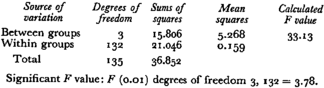
The cirque-floor elevations were then subjected to a Scheffe test for all possible comparisons (Reference RoscoeRoscoe, 1975). The results of the Scheffe test indicate that the mean cirque-floor elevations of the Boulder–Stillwater drainages are significantly lower than those in the Rosebud–Rock Creek drainages (Table II).
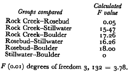
This distribution strongly suggests that the four levels of cirque development found in the Boulder, Stillwater, Rosebud, and Rock Creek drainages indicate that the regional snow-line fluctuated a minimum of four times during the Pleistocene.
Cirque levels higher than the modern snow-line suggest complete deglaciation during the thermal maxima and a re-appearance of small glaciers during the Little Ice Age or Neo-glaciation. Reference GrafGraf (1976), using length–width and length–height ratios, has shown that glacierized cirques in the Beartooth Mountains are larger in size than abandoned cirques having the same elevations and orientations. The abandoned cirques typically have steep narrow sides and shallow depths. The presence of abandoned cirques existing above the modern snow-line suggests that the geometry of the cirque does not allow it to catch the amount of snow required for glacier formation under modern climatic conditions. The geometry of the cirque may not have been such a critical factor during the Neoglaciation when temperatures were cooler. The lowering of temperature during the Neoglaciation would have allowed an accumulation of snow under the present precipitation rates.
Summary and conclusions
The distribution of cirques in the Absaroka and Beartooth Mountains indicates that a minimum of four major fluctuations of the snow-line occurred during the Pleistocene. A comparison of the composite Pleistocene snow-line and the modern regional snow-line showed a depression of 305 m of the Pleistocene snow-line. This depression of the Pleistocene snow-line resulted in a lowering of the mean annual Pleistocene temperature a minimum of 1.95 deg. The parallel relationship found to exist between the modern regional and Pleistocene snow-lines indicates that changes in mean annual temperatures were the major factor resulting in the lowering of the Pleistocene snow-line. The slope of the snow-line suggests that sources of moisture and air-mass flow patterns during the Pleistocene did not differ appreciably from those of the present.
The depression of the Pleistocene snow-line and cirque development in the Absaroka and Beartooth Mountains is apparently the result of a lower mean annual temperature.



