


Introduction
Dating the Dolmens and the Problematics of the Study
One of the greatest difficulties in research into megalithic monuments is the determination of their age. The main problems arise in the sites themselves and types of samples used to date them. Most sites are characterized by complex stratigraphic sequences and long periods of use, in which the diverse stages that are recorded make it very difficult to establish the chronological sequence. Moreover, the radiocarbon dates obtained mostly for organic materials (charcoal, bone, wood, etc.) provide different chronometric results and possibilities for interpretation.
The greatest limitations emerge in the correlation of the resulting dates with the construction events, architectural rebuilding and episodes of use. Thus, the dates obtained for human bones in dolmens and collective burials provide a temporal range for funerary activity and not the building of the monument; in that way effectively determining a terminus post quem for its construction (Scarre Reference Scarre2010).
However, progress has been made in recent years. First, the dating methods have improved (Bronk Ramsey Reference Bronk Ramsey1995; Bayliss and Whittle Reference Bayliss and Whittle2007), owing to the application of Bayesian statistical modeling for human osseous remains (Bronk Ramsey Reference Bronk Ramsey2009) and improvements in the intervals in the calibration curves (Heaton et al. Reference Heaton, Köhler, Butzin, Bard, Reimer, Austin, Bronk Ramsey, Grootes, Hughen and Kromer2020; Reimer et al. Reference Reimer, Austin, Bard, Bayliss, Blackwell, Bronk Ramsey, Butzin, Cheng, Edwards, Friedrich, Grootes, Guilderson, Hajdas, Heaton, Hogg, Hughen, Kromer, Manning, Muscheler, Palmer, Pearson, Van der Plicht, Reimer, Richards, Scott, Southon, Turney, Wacker, Adolphi, Büntgen, Capano, Fahrni, Fogtmann-Schulz, Friedrich, Köhler, Kudsk, Miyake, Olsen, Reinig, Sakamoto, Sookdeo and Talamo2020). Second, through the development of studies on stratified mortuary deposits with numerous calibrated radiocarbon dates for short-lived samples, especially bones. These have suggested that the periods of use of the tombs in several parts of western Europe correspond to specific generations of individuals (Whittle et al. Reference Whittle, Barclay, Bayliss, Mcfayden, Schulting, Wysocki and Bayliss2007, Reference Whittle, Bayliss and Healy2008; Chambon et al. Reference Chambon, Blin, Bronk Ramsey, Kromer, Bayliss, Beavan, Healy and Whittle2017; Steuri et al. Reference Steuri, Siebke, Furtwängler, Szidat, Krause, Lösch and Hafner2019; Meadows et al. Reference Meadows, Rinne, Immel, Fuchs, Krause-Kyora and Drummer2020).
The current state of knowledge of the age of megalithic monuments in the southern Iberian Peninsula is uneven. In recent years, research based on long series of radiocarbon dates for megalithic tombs in the southeast of the peninsula (Lozano Medina and Aranda Jiménez Reference Lozano Medina and Aranda Jiménez2018) has obtained interesting results for the chronologies of the necropolises of El Barranquete (Aranda Jiménez and Lozano Medina Reference Aranda Jiménez and Lozano Medina2014; Aranda Jiménez et al. Reference Aranda Jiménez and Lozano Medina2017a), Panoría (Aranda Jiménez et al. Reference Aranda Jiménez, Lozano Medina and Sánchez Romero2017b, Reference Aranda Jiménez2020a, Reference Aranda Jiménez, Milesi García and Hamilton2022), Las Churuletas, La Atalaya and Llano del Jautón (Aranda Jiménez et al. Reference Aranda Jiménez, Lozano Medina, Camalich Massieu, Martín Socas, Rodríguez Santos, Trujillo Mederos, Santana Cabrera, Nonza-Micaelli and Clop García2017c), Los Millares (Aranda Jiménez et al. Reference Aranda Jiménez2020b; Molina et al. Reference Molina, Mederos, Delgado-Huertas, Cámara, Peña, Martínez, Esquivel, Granados, Jiménez-Brobeil and Esquivel2020) and Mojácar (Aranda Jiménez et al. Reference Aranda Jiménez, Camalich Massieu and Martín Socas2020c).
In contrast, in the southwest of the peninsula fewer monuments have been dated by a long series of samples. Studies have focused on Copper Age collective tombs, such as the hypogea and tholoi at the mega-site of Valencina de la Concepción (García Sanjuán et al. Reference García Sanjuán, Vargas Jiménez, Cáceres Puro and Costa Caramé2018), the Tholos of Montelirio (Bayliss et al. Reference Bayliss, Beavan, Bronk Ramsey and Delgado Huertas2016), the necropolis of La Orden-Seminario (Linares-Catela and Vera Rodríguez Reference Linares-Catela and Vera-Rodríguez2021) and several corbelled tombs in Alentejo, such as Centirã 2 (Robles et al. Reference Robles, Monge Soares, Alves, Curate, Valério, Peleja and Jiménez Ávila2013), Cardim 6 (Valera et al. Reference Valera, Figuereido, Lourenço, Shaw Evangelista, Basilio and Wood2019) and Perdigões 4 (Valera and Wood Reference Valera and Wood2020).
The chronological study of dolmens in southwest Iberia is seriously limited by the small number of dated sites in both Spain and Portugal. Only 62 megalithic funerary monuments have been dated by 134 radiocarbon determinations on organic materials (bone, charcoal, marine shells). The present study has not included four dates from Poço da Gateira 1, Gorginos 2, Anta Grande da Comenda da Igreja and Farisoa 1 (Whittle and Arnaud Reference Whittle and Arnaud1975), because they were obtained on ceramic samples by thermoluminescence and suffer from a high standard deviation of the chronometric results (Table S1). At most sites, one, two or three dates have been obtained, generally for the funerary levels. In contrast, few sites are dated by four or more determinations for different contexts, as at Santa Margarida 3 (Gonçalves Reference Gonçalves2003a), Azután (Bueno et al. Reference Bueno Ramírez, Balbín Berhmann and Barroso Bermejo2005), Soto (Linares-Catela and Mora Molina Reference Bueno Ramírez, Linares-Catela, Balbín Berhmann and Barroso Bermejo2018), Carrascal (Silva et al. Reference Silva, Sousa, Boaventura and Scarre2019), Pedras Brancas (Silva et al. Reference Silva, Catarina Sousa and Scarre2021) and Campo de Hockey necropolis (Vijande-Vila et al. Reference Vijande-Vila, Díaz-Zorita Bonilla, Morell-Rovira, Olalde, Sánchez-Barba Muñoz, Domínguez-Bella, Emslie, Becerra-Martín, Rubio-Salvador and Fernández-Sánchez2022). Additionally, no chronological sequences have been established at particular dolmens with stratified dates and using Bayesian modeling. Regional analyses integrating the radiocarbon dates from both countries are equally scarce (Boaventura Reference Boaventura and García Sanjuán2011; García Sanjuán et al. Reference García Sanjuán, Weathley, Costa Caramé and García Sanjuán2011; Boaventura and Mataloto Reference Boaventura and Mataloto2013; Carvalho and Cardoso Reference Carvalho and Cardoso2015; Mataloto et al. Reference Mataloto, Andrade and Pereira2017; Schulz Paulsson Reference Schulz Paulsson2017; Rocha Reference Rocha2020). This makes it very difficult to determine the temporalities of the different construction models. In this context, the chronology of the dolmens has traditionally been based on evolutionary formal schemes in which chrono-cultural sequences are established by typological classifications of architectures and grave goods.
The present study is based on the radiocarbon chronology of the El Pozuelo complex and its study contextualized in the diachronic sequence of funerary megalithic sites in the Iberian southwest. It therefore sets two inter-connected objectives. The first focuses on determining the chronological sequence of the Los Llanetes cluster. These four monuments are characterized by a complex architectural sequence, long temporality and diversity of functions. The combined analysis of the stratigraphic-structural sequence and the Bayesian modeling of 27 radiocarbon dates for charcoal samples, mostly short-lived, is able to establish the chronologies of the construction, structural reform, uses and reuses of the monuments during Later Prehistory. It should be noted that this is the first chronological study of dolmens in the southwest of the Iberian Peninsula to be supported by Bayesian modeling and a long series of stratified dates from the construction units, internal and external structures and levels of use.
The second objective aims to contextualise the chronometric results within the dynamics of funerary megalithic dolmens in southwest Iberia, which comprise a long sequence from the late fifth millennium to the start of the second millennium cal BC. The area of study encompasses the southwest of the peninsula, principally the zone to the south of the River Tagus, including the Portuguese regions of Estremadura, Alentejo and Algarve, and Western Andalusia (Huelva, Cádiz, Seville, Córboba, and Málaga provinces). In this geographic area, several models with similar traits have been proposed for the period from the Middle Neolithic to the Early Bronze Age: protomegalithic tombs, dolmens and megalithic cists. The area is characterized by architectural polymorphism and territorial concentrations in the types of monuments. This may correspond to building specialisations, regional styles and/or synchronic or diachronic processes.
With this study, the statistics mentioned above increase to 66 sites dated by 161 determinations, of which 9 dates from previous occupation levels of 8 dolmens have been excluded for the chronological models (Table S2). These are occupation or activity traces preceding the construction of the monuments, and in some cases might be significantly older. The analysis and clustering of the 152 dates available (27 news, 125 published) for the different architectural models may contribute to establishing the chronology of the dolmens and support the proposal of more robust temporal schemes in southwest Iberia.
The Megalithic Complex of El Pozuelo
The El Pozuelo complex (Zalamea la Real, Huelva) is in the Eastern Andévalo region, at the southwestern end of the Sierra Morena (Figure 1). It is located in the Volcanic-Sedimentary Complex of the Iberian Pyrite Belt, where basic, acidic and intermediate volcanic rocks outcrop. The largest concentration of dolmen necropolises in the Province of Huelva is found in this environment, and it is also one of the densest groups in the Iberian southwest.
Location of the Los Llanetes cluster, El Pozuelo complex: (a) siting and distribution of El Pozuelo megalithic group; (b) Megalithic landscape of Los Llanetes; (c) view of the Los Llanetes cluster.
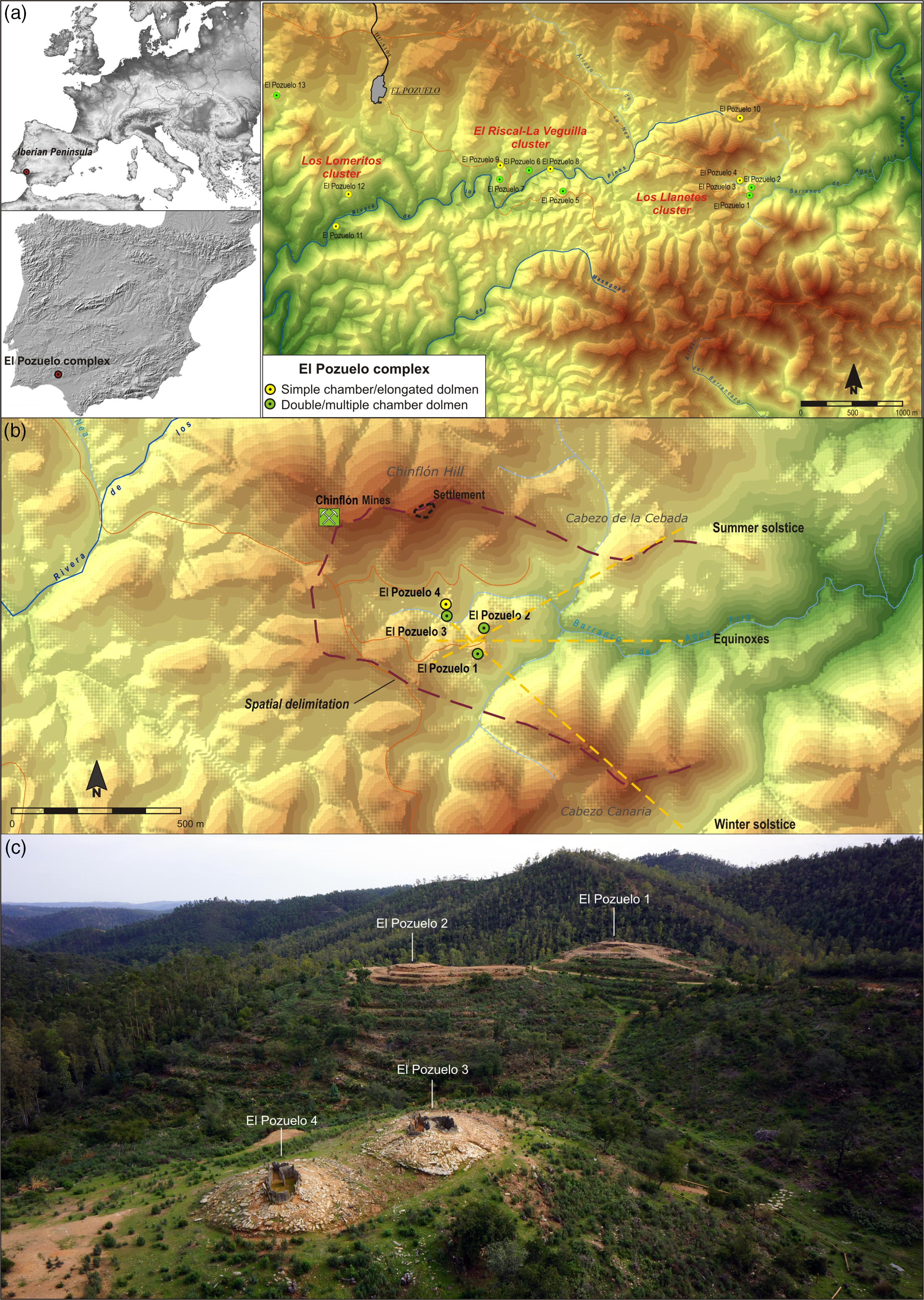
This megalithic necropolis is the best known and most outstanding, as it is the largest and most diverse in its architecture (Cerdán et al. Reference Cerdán, Leisner and Leisner1952; Leisner and Leisner Reference Leisner and Leisner1956, Reference Leisner and Leisner1959; Piñón Varela Reference Piñón Varela1987, Reference Piñón Varela2004; Linares-Catela Reference Linares-Catela and Laporte2016). It consists of 13 megalithic monuments in an east-west band around two streams that are tributaries to the headwaters of the River Tinto (Figure 1a). It is arranged in three clusters. Los Llanetes in the east, at the head of the Agua Fría Ravine and next to the Chinflón copper mines, formed by four dolmens (no. 1–4); El Riscal-La Veguilla, on the bank of Los Pinos, with five dolmens (no. 5–9); and Los Lomeritos, with two dolmens (no. 11 and 12). The dolmens of Los Rubios (no. 10) and Martín Gil (no. 13) are located at either end of the group. The dolmens are noteworthy because of the variety in the structure of the orthostats inside circular mounds of clay and stones. They include dolmens with a simple chamber (no. 8, 11, and 12), dolmens with an elongated chamber (no. 9 and 10), a covered gallery with central pillars (no. 4) and dolmens with multiple chambers in different spatial designs: double chambers (no. 1, 2, and 3); cruciform designs with two (no. 7) or four side-chambers (no. 13); and asymmetric structures with four asymmetric chambers, several antechambers, and passages (no. 5 and 6).
The chronology of these monuments has traditionally been based on the evolution in the typology of the architecture and grave goods. The simpler dolmens, those with a single or elongated chamber were dated in the Late Neolithic, due to finds of certain type-fossils for the fourth millennium BC in the sequence of regional megalithism, such as geometric artefacts, adzes, pottery types, plaque and/or cruciform idols, etc. However, the monuments with multiple chambers have been interpreted as the expression of a local architectural style, representative of late megalithism in the Copper Age and developed as a consequence of the emergence of the first mining-metallurgical societies in the area (Cerdán et al. Reference Cerdán, Leisner and Leisner1952; Blanco Freijeiro and Rothenberg 1981). Before now, only one radiocarbon date was available, for El Pozuelo 6. It has even been argued that the whole necropolis developed in the second half of the third millennium BC (Nocete et al. Reference Nocete, Lizcano, Nieto, Sáez, Linares, Orihuela and Rodríguez2004).
Materials and methods
Architectural Sequence and Charcoal Sampling
The present study has focused on the four monuments in Los Llanetes, the eastern cluster in the El Pozuelo megalithic complex. They are located in the valley; distributed in pairs of monuments and creating an area reserved for the realm of the dead, within a megalithic landscape that includes the settlement on Chinflón Hill, the copper mines and the natural surrounding formations (Figure 1b). Dolmens 1 and 2 occupy two different mounds connecting by gentle slopes, while Dolmens 3 and 4 are on a flat promontory (Figure 1c). They were excavated in 1946, giving rise to the study of the architectures and grave goods (Cerdán et al. Reference Cerdán, Leisner and Leisner1952).
The documentation and materials used for the present study come from two archaeological fieldwork projects in 2009–2010 and 2012–2014. This work employed a methodology that included extensive excavation of areas, a full architectural study of internal spaces and the selective micro-spatial exploration of outer areas: the mounds, front access zone and the surrounding areas. The stratigraphic record has not been exhausted in any of the excavated sectors, leaving sections for future research. This working method has succeeded in reconstructing the stratigraphic-structural sequence of the remains and their position in a relative chronology; and it has identified the structural phases, the stages of activity and materials associated with them.
Research in the Los Llanetes cluster enabled an interpretation of the stratigraphy, architecture and diachronic sequence that is more complex archaeologically than was traditionally thought (Linares-Catela Reference Linares-Catela2017). Three elements can be emphasized:
-
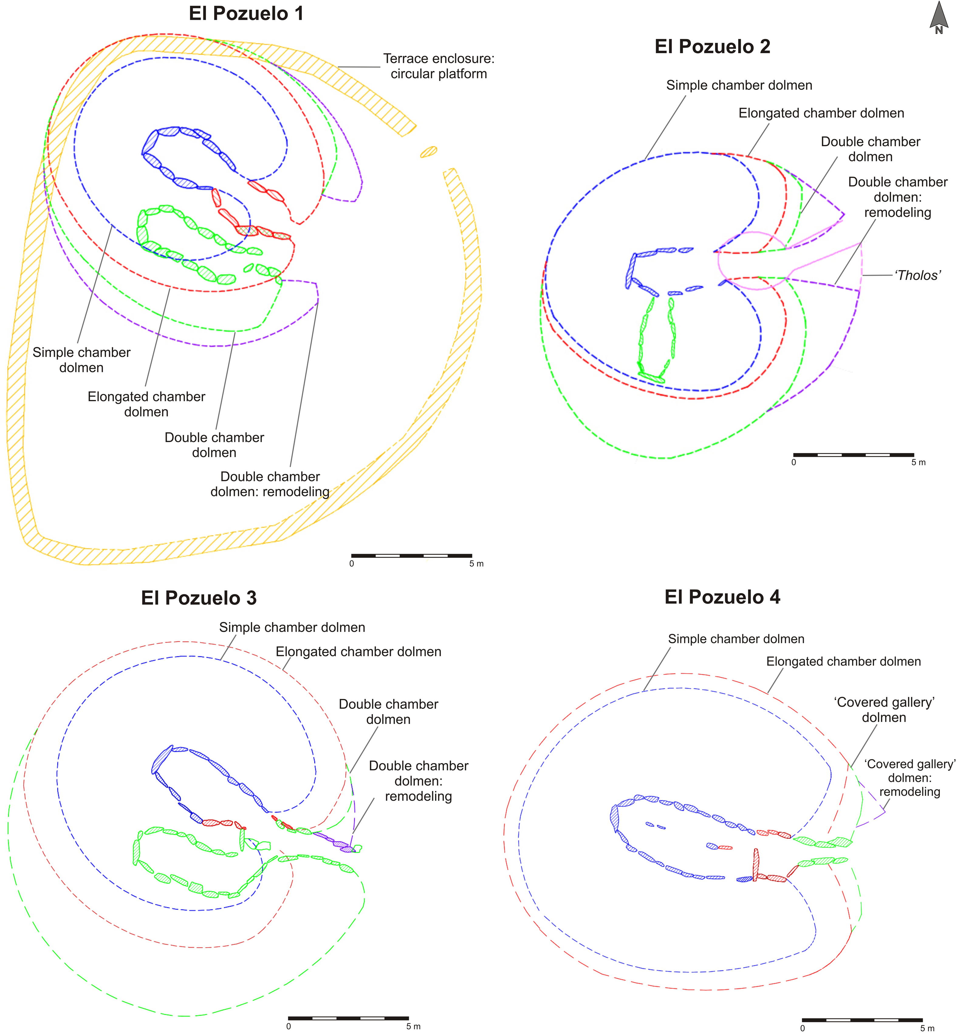
The final form of the monuments is the result of the concatenation of a series of architectural projects. In each of these, different models of dolmens were superimposed, with a tendency from simpler to more complex monuments (Figure 2). Each model displays particular characteristics and was constructed with different purposes and intentions.
Figure 2Architectural sequence of the Los Llanetes cluster, El Pozuelo complex. Evolution of the monuments.

-
The existence of “megalithic operational chains” associated with each primary building project or reform. The work was characterized by the sophistication, specialization, and continuity of a technical tradition, seen in the selection of materials, treatment and building systems (Linares-Catela Reference Linares-Catela and Ard2021).
-
The long and complex duration of the cluster, with materials characterising different chrono-cultural phases in Later Prehistory, from the Late Neolithic to the Bronze Age, and various historical periods.
Nonetheless, each dolmen displays particular stratigraphies, an architectural biography and specific activity in Later Prehistory.
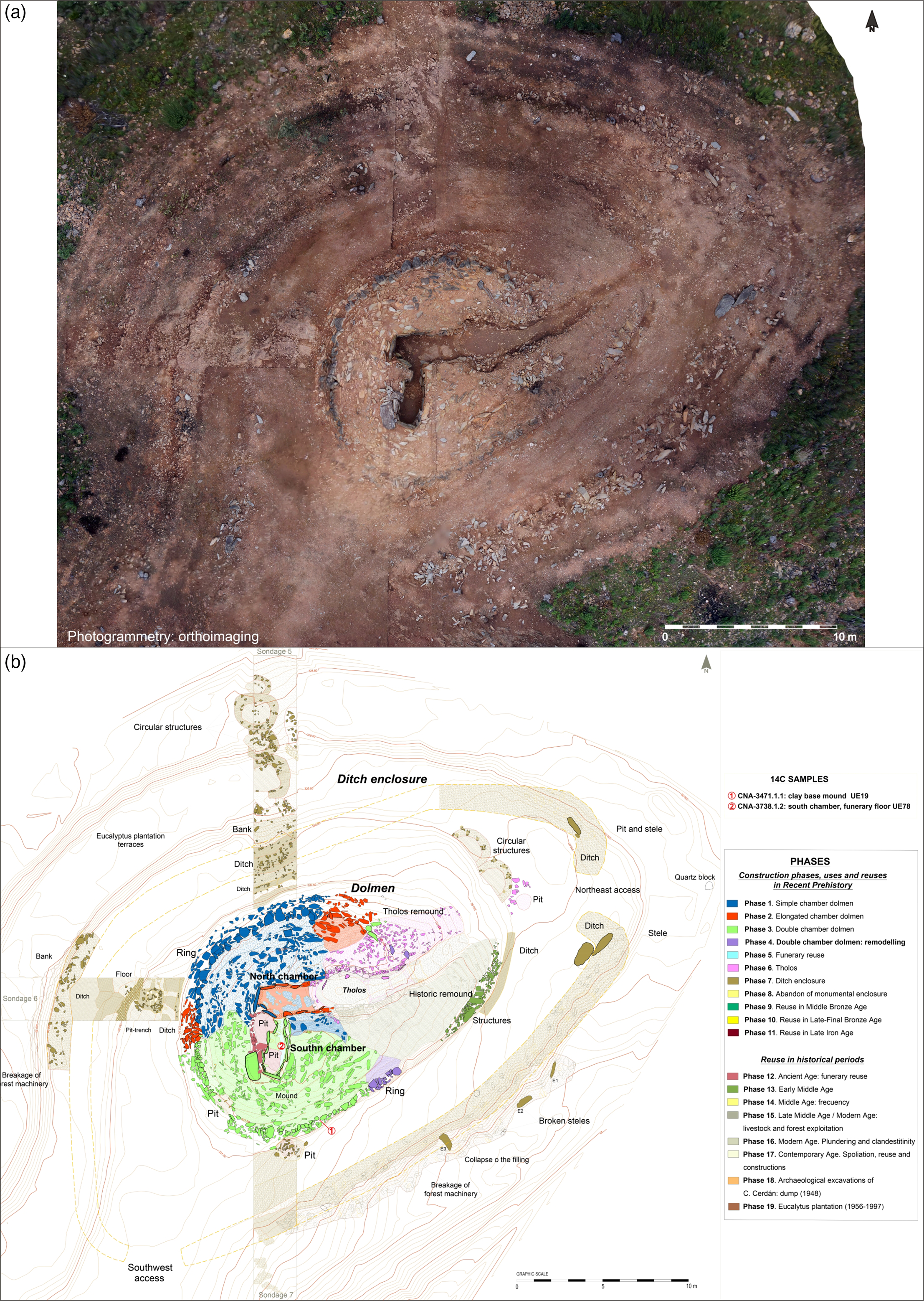
Dolmen 1 is a mound containing two parallel chambers with independent accesses (Figure 3). They clearly differ in their shape, size and heights. The circular mound is delimited by a ring of kerbstones. On the outside, a circular stone platform and two stepped levels of terraces are delimited by drystone walls that form a monumental enclosure that is more recent than the dolmen (Figure 3a). The archaeological study determined a stratigraphic-structural sequence (Figure 3b) with the following phases:
El Pozuelo 1: (a) photogrammetric survey; (b) plan with architectural phases, stratigraphic-structural sequence and location of 14C samples.

-
Phase 1: dolmen with an elongated oval chamber oriented to the SE (117º). It corresponds to half the structure of the north chamber, from its middle to the head. It is 3.75 m long, with a maximum width in the middle of 2.05 m and a height of up to 1.80 m. It is formed by large orthostats, the first of which rests on the headstone while the others are vertical. The floor is on the bedrock which was lowered with a slope down from the access, with a stele pit in the middle, aligned with the axis of the chamber. It is inside a circular mound 9 m in diameter.
-
Phase 2: a dolmen with an elongated chamber that was formed by adding two curving walls of stones to prolong the original axis of symmetry. It reaches a length of 7 m. The axial stele was placed in the access section. The oval mound, with a kerb, reached 12.50 m in length on its long axis.
-
Phase 3: dolmen with double parallel chambers and independent entrances. Two sub-phases can be differentiated. In Phase 3A, the work involved removing the southern half of the pre-existing mound, building the south chamber and its access vestibule, moving several stones, paving the north chamber with clay, and rebuilding the mound. This created a circular mound 12.60 m in diameter delimited by kerbstones. The south chamber, which was lower and built with smaller stones than the contiguous one, is curved and 6.50 m long. It has two headstones.
In Phase 3B, the frontal façade was transformed and repairs were made to the south chamber. The work enlarging the mound formed an atrium with an open monumental façade including two access vestibules oriented generally towards the east (90°). The north wall of the south chamber was repaired by moving the orthostats and the entrance of the north chamber was transformed by removing the first two stones and replacing the axial stele.
-
Phase 4: the outer area was monumentalized. The surrounding terrace and structures in the north and front were built.
-
Phase 5: the outer frontal area was monumentalized by laying a pavement, several altars, circular structures and steles, with which ritual hearths in the atrium are associated.
-
Phase 6: funerary reuse.
-
Phase 7: the dolmen was partially dismantled and the area of terraces with a circular platform was built, which implied breaking and removing the capstones, orthostats and steles and digging out the mound for their reuse. The monumental enclosure includes two types of structures. First, a drystone wall platform 23.50 m by 20.50 m in size that surrounded the dolmen, between 0.50 and 1.0m high, which contained large stones and slabs from the dolmen. It had several accesses; one on the north-east side, segmented by an orthostat reused as a standing-stone, and a ramp on the west side. It was restructured and rebuilt on two occasions (Phases 7B and 7C). Second, two sub-quadrangular surrounding terraces were built lower down, delimited by drystone walls with the shape of an incline towards the outside.
-
Phase 8: the terraced enclosure was abandoned.
-
Phase 9: reuse in the Middle Bronze Age, when the mound of the dolmen was reshaped by partially emptying the north chamber, where a mining hammer with a central groove was found.
-
Phase 10: reuse in the Late-Final Bronze Age, when a pit was dug in the mound.
-
Phase 11: reuse in the Late Iron Age, as witnessed by the pit dug in the north chamber.
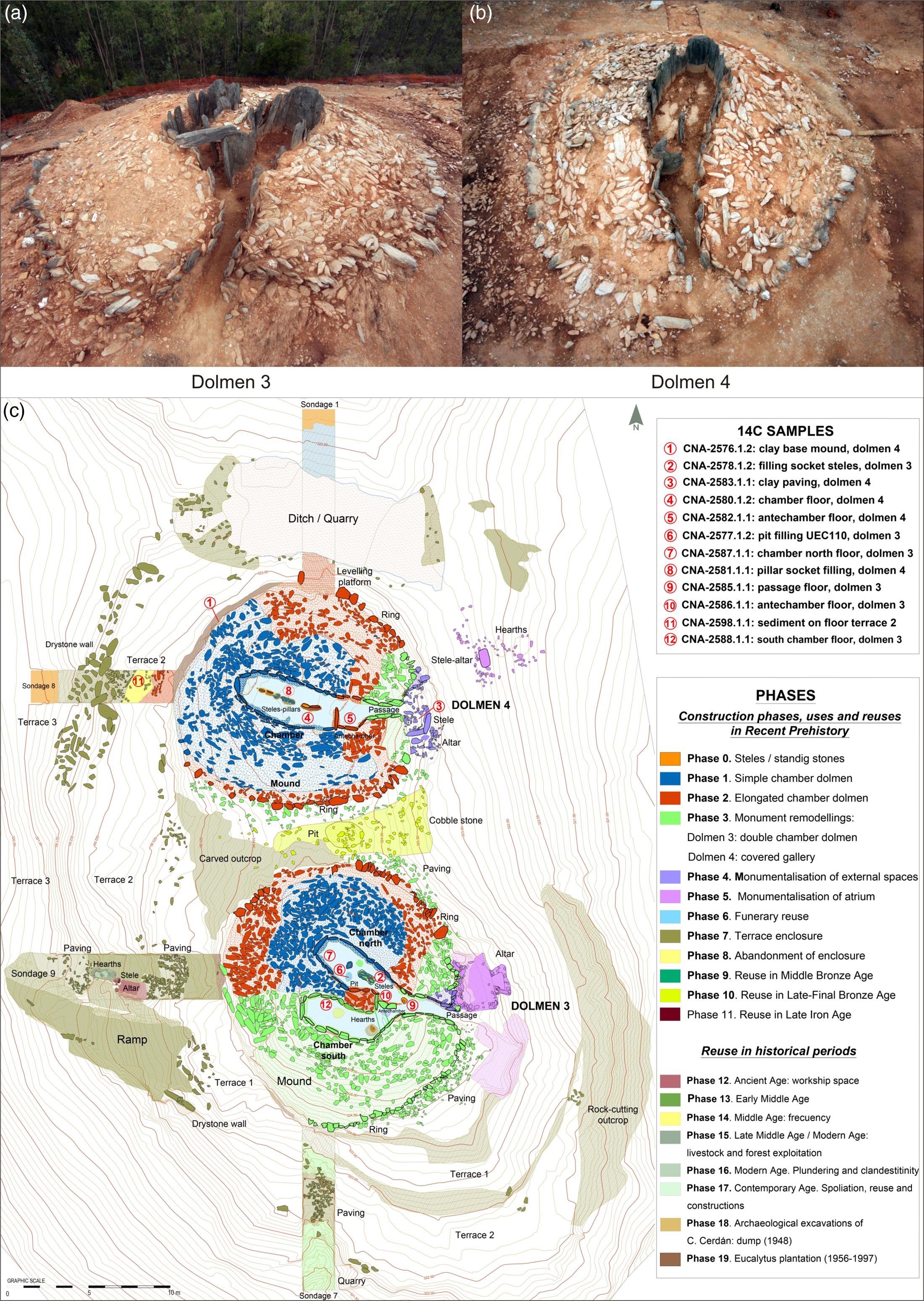
Dolmen 2 is a monument with double perpendicular chambers (Figure 4). Its circular mound is delimited by a prominent levelling platform and a ring of kerbstones with protruding oblique stones, created in four architectural projects (Figure 4a). The archaeological study (Figure 4b) has determined the following phases.
El Pozuelo 2: (a) photogrammetric survey; (b) plan with architectural phases, stratigraphic-structural sequence and location of 14C samples.
-
Phase 1: dolmen with an elongated oval chamber. This is the west chamber formed by two walls and a headstone, on a northwest-southeast line. An old stele was reused with engravings on the extrados. It was 3.50 m long, with a maximum width of 1.70 m in the middle and a maximum height of 1.60 m. The floor was dug into the bedrock. The oval mound was 9.80 m long on its long axis.
-
Phase 2: dolmen with an elongated chamber 5.25 m long. Its construction involved dismantling and partly rebuilding the north wall of the old chamber, as well as lengthening the structure and enlarging the mound by a metre on the eastern front, reaching up to 2 m in height. The chamber was rotated towards the east (90°), which was the axis of symmetry of the monument.
-
Phase 3: dolmen with double perpendicular chambers. Its design involved partially digging out at least one orthostat and part of the old mound, as a hole was made for the south chamber. The mound and kerbstone ring were rebuilt next to the interior. The chamber, 3.30 m long, 1.50 m wide, and 1.40 m in maximum height, was oriented towards the north (10°). It was formed by a headstone and regular slender orthostats and was lower than the original one, with a floor of beaten clay over the bedrock. The elliptical mound was 12.75 m long on its axis of symmetry.
-
Phase 4: the east front of the mound was enlarged by adding two sections of the ring and filling the mass of the mound, which reached 13.25 m in length.
-
Phase 5: funerary reuse of the chambers.
-
Phase 6: reuse of the space for a possible construction of a tholos-type structure in the eastern half. This meant the mound of the monument was reformed. The negative structure is characterized by a passage and the start of a circular chamber with slabs and stone walls, oriented towards the northeast (67°).
-
Phase 7: the monument was partly dismantled, and the remains and materials were added to the surrounding ditch enclosure, which has only been delimited on the surface. The enclosure is elliptical, oriented on a northeast alignment (67°), formed by a discontinuous perimeter ditch dug in the substrate with an embankment towards the exterior. The ditch would have a U- or V-shaped cross-section, about 1.50 m wide and up to 0.80 m deep, delimiting an area of 36.50 m by 23 m. A “pincer-shaped” access in the northeast was flanked by a stele on each side. Another access would have been on the southwest side. On the inside there was a small perimeter ditch, and two groups of circular earthen structures were located on the outside.
-
Phase 8: the monumental enclosure was abandoned.
Dolmen 3 is characterized by an internal structure formed by two parallel chambers 4.5 m in length connected by an antechamber and a converging passage (Figure 5), 2.60 m long. They were in a circular mound 16.50 m in diameter and up to 3.50 m high above the outer ground level, delimited by a ring of kerbstones with a circumference of 50 m. Engraved and painted steles were recycled in the antechamber (Figure 5a). The following building phases in Later Prehistory have been determined by the archaeological study (Figure 5c).
El Pozuelo 3–4: (a) aerial view of dolmen 3; (b) aerial view of dolmen 4; (c) plan with architectural phases, stratigraphic-structural sequence and location of 14C samples.
-
Phase 1: dolmen with an elongated oval chamber, corresponding to the north chamber, 4.60 m long, 2.10 m wide, and up to 2 m high, with an axis of symmetry on 124° (southeast). It has a headstone, walls with vertical stones placed regularly and a floor excavated into the substrate. It would have had axial steles. The chamber was inside a circular mound 11 m in diameter.
-
Phase 2: dolmen with an elongated chamber formed by adding a trapezoidal antechamber in the access, 1.65 m long and 1.60 m high. The mound was enlarged and reached about 13 m in diameter.
-
Phase 3: Dolmen with parallel double chambers and converging passage. Its construction involved partially dismantling the old mound, adding the south chamber and rebuilding the antechamber, the access passage and the wedge-shaped vestibule. The axis of symmetry was rotated towards the east (90°), marked by the projection of the axial steles in the antechamber with a free-standing stele in the access. The south chamber is elbow-shaped, with two headstones and more slender stones in the walls which partly overlap in the curved section. The trapezoidal antechamber, 2.30 m long, contains seven recycled steles with engravings in the places of transition: stele in the frontal closure, two jambs in the axis of symmetry, one in the access and the other three in the walls. The mound was enlarged and reached its maximum circular form, with a stone pavement around it.
-
Phase 4: transformation of the front façade and the access, including the partial reconstruction of the passage wall on a 110° alignment (southeast). This created a narrow access and an enlargement of the façade with vertical slabs.
-
Phase 5: the front access was monumentalized, conditioning the position of two altars: a stone and clay altar attached to the atrium and another one carved in the rock.
-
Phase 6: funerary reuse of the interior of the dolmen.
Dolmen 4 consists of a covered gallery in a circular mound on a levelled platform, 15.50 m in diameter and reaching 3.50 m in height above the exterior ground level (Figure 5b). The structure of orthostats 10.25 m in length is segmented into three areas: open passage, antechamber with a transversal stone, and an elongated oval chamber with central pillars. Its height varies from 1.30 m to 1.80 m. The floor was dug into the bedrock. The dolmen was entered down steps carved into the rock, with a stele on the left-hand side. The stratigraphic and structural study has revealed the following phases in its construction (Figure 5c).
-
Phase 1: construction of an elongated oval chamber, 6.75 m long and up to 3.60 m wide, with 6 or 7 central pillars. These supports may have been recycled steles, which marked the axis of symmetry on 110° (southeast). The regular orthostats were placed vertically. The floor sloped down from the access to the headstone. The structure was in a circular mound, 12.50 m in diameter on a foundation of hard compacted clay.
-
Phase 2: dolmen with an elongated chamber 7.75 m long. It was created by adding a quadrangular antechamber at the end by placing three orthostats on both sides of the walls and the transversal position of a recycled slab. This support, with side grooves for it to be fixed, was shortened so that it could be reused. The first pillar was replaced and rotated towards the east (90°), marking the new orientation of the axis of symmetry. The mound was enlarged, and made into an oval shape, with a length of 15 m on its long axis.
-
Phase 3: covered gallery dolmen with an outer passage and façade with a stepped vestibule. The work involved lengthening the structure with three orthostats leaning at 30–45° on each side, with a rise from 0.90 to 1.40 m, reaching the full length of the structure. The mound was enlarged concentrically to reach its final size.
-
Phase 4: the front façade was monumentalized and transformed. This involved placing the stones in the wedge-shaped vestibule and carving the access steps in the rock substrate.
-
Phase 5: the external area was monumentalized with two actions. A stele was placed with a quadrangular altar at its foot, and a stone pavement was laid in the outer vestibule, while a stele-altar was associated with hearths in the front outer area.
-
Phase 6: funerary reuse of the interior of the dolmen.
Phases 7–10 are the same in Dolmens 3 and 4, which were located in the same place. The following actions took place in each phase:
-
Phase 7: partial dismantling to build the surrounding terraced enclosure, formed by three levels delimited by drystone walls and a ramp carved in the outcrop of rock on the southwest side. This project implied removing and breaking the capstones, orthostats, and pillars, as well as digging out the mound, etc.
-
Phase 8: abandonment of the terraced enclosure.
-
Phase 9: reuse in the Middle Bronze Age, both of the inner area without a cover and of the outer areas.
-
Phase 10: reuse in the Late-Final Bronze Age, as evidenced by the find of miners’ hammers with a central groove, and a funerary pit with a stele and a pavement between Dolmens 3 and 4.
The radiocarbon dates for the four monuments were obtained from samples of charcoal. This is the only type of organic macro-remain conserved in the dolmens and found in most of the stratigraphic and architectural units. No bones could be dated because no fragments have been preserved owing the high acidity of the clay. These unfavourable physical-chemical conditions destroy the osseous remains, as observed at other sites in the western Sierra Morena (Nocete et al. Reference Nocete, Lizcano, Nieto, Sáez, Linares, Orihuela and Rodríguez2004). Therefore, in these dolmens, charcoal is the only organic material susceptible of being dated, as in the case of most sites in the Iberian Pyrite Belt and other southwestern regions, where highly acidic soils are common. As a result, during the excavation all the charcoal fragments were collected systematically when dry sieving the sediment from the stratigraphic units and hearths with concentrations of remains. In total, 644 charcoal remains were recorded, mostly from prehistoric contexts. The anthracological study succeeded in identifying each taxon and discriminated between the use of twigs and branches.
The presence of charcoal at megalithic sites may be due to different reasons and social practices, as wood was used in structures built during the construction of the monuments, to cremate individuals during the funerary activity, and in hearths and ritual fires (Zapata and Figuerial Reference Zapata, Figueiral and Buxó2003). Its preservation depends on various taphonomic factors. It is therefore essential to determine the combustion processes derived from human activity and the natural and/or anthropic post-depositional processes resulting in its presence at archaeological sites (Théry Parisot et al. Reference Théry Parisot, Chabal and Chrzavzez2010).
A strategy was followed for the selective sampling of charcoal from building units, constructions and levels that enable the chronology of the phases to be established. Priority was given to apparently unaltered archaeological contexts displaying clear stratigraphic relationships of superimposition, succession, horizontality and/or continuity within the architectural sequence. In this way, 70 samples were chosen to be dated. The selection of charred wood samples was based on four criteria:
-
1. The presence and suitability to date levels of the constructions, other structures and the uses that mark the rhythm and diachronic development of the monuments.
-
2. The degree of alteration caused by the successive reuses of the site.
-
3. The preference for short-lived species, especially branches, in order to avoid the old-wood effect. Thus, fragments of bush branches (Rosaceae, Ericaceae, Olea, Arbustus sp.) were chosen in the case of charcoal dispersed in the sediment or present in the interior and exterior levels of the monuments, associated with either funerary or ritual activity. However, dates have also been obtained for long-life species (Quercus subgenus Quercus, Quercus ilex) in certain stratigraphic units or structures (pavements, ditches and foundation pits, postholes, and hearths) when short-lived charred wood samples were not available.
-
4. Their suitability to define the temporality of the constructions or levels and to establish short-duration events connected with specific ritual practices, such as the hearths.
The archaeological contexts and the chronometric results allow the dates to be sorted into two large temporal groups. Thus, 27 dates correspond to Later Prehistory, from the Late Neolithic to the Iron Age. The other 43 dates are correlated with different historical reuses, from Antiquity to the Contemporary Age. The number of prehistoric dates per dolmen is unequal: 13 for Dolmen 1, two for Dolmen 2, six for Dolmen 3, five for Dolmen 4 and one for the outer area around Dolmens 3 and 4 (Table 1; Figures 3–5). Priority was given to the selection of samples from:
Archaeological contexts of dated charcoal samples from the Los Llanetes cluster, El Pozuelo complex.
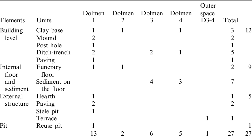
-
Construction levels and elements (n=12), of two types: (a) permanent structures, such as the foundations of the mounds and walls (3), mounds (2), ditches or foundation pits (5) and pavements (1); and (b) ephemeral structures, such as postholes (1), associated with the timber used during the construction of the megaliths, like the structural framework, tripods, and trestles. The charcoals were found in the sedimentary fill and in the stratigraphic levels sealed after the construction activity, remaining buried in the case of the post holes of wooden structures and/or under the structures in the case of durable architectural elements of stone and clay: mounds, foundation ditches, sockets, and clay base levels. Therefore, even assuming that some charcoals may be older residual remains incorporated into the construction levels, the samples provide a terminus post quem for the building and/or reform events in the monuments and the chronometric results will be very close to the time of the construction or modification of the architecture. Furthermore, we have sufficient guarantees that it is not charcoal from later activities.
-
Floors and sediments over floors (n=9), differentiating between activity levels in the chambers (2) and sediment formed on surfaces and internal transit areas (7). These are pieces of charcoal deposited in those levels during the different activities and funerary and ritual practices carried out in the dolmens. Again, these samples date specific events in the use of the structures.
-
External structures (n=5), differentiating between a hearth (1), stele pit (1), sediments over pavements (2) and a terrace (1). The charcoals has been recorded in structures that were constructively backfilled (foundation pits), covered by sediment after use by natural and/anthropic processes (hearths) and deposited on the ground (pavements) as a result of fires or combustion practices carried out in the site. These samples can date particular activity phases, monumentalization processes and ritual practices carried out in the outer areas, sometimes of a short duration, as in the case of the hearths.
-
Pit dug during the reuse of interior areas (n=1). The charcoal was buried in an intentional fill of the structure in Dolmen 1.
Bayesian Methods and Models
The radiocarbon dates were obtained from small charcoal fragments (less than 1 g in weight) analyzed in the Spanish National Accelerator Centre (CNA) in Seville. This laboratory follows rigorous protocols in the preparation, extraction of carbon dioxide by graphitization, treatment, and measurement of the samples by accelerator mass spectrometry (AMS) (Santos et al. Reference Santos, Gómez Martínez and García León2009, Reference Santos, Agulló, Diéguez and Gómez Martínez2015). All the samples provided a reliable radiocarbon age (Stuiver and Polach Reference Stuiver and Polach1977) with percentages of radiocarbon concentrations (pM) suitable for the calculation of the age BP. The δ13 values are provided by measuring the graphite by AMS. The BP ages were calibrated with the IntCal20 curve (Reimer et al. Reference Reimer, Austin, Bard, Bayliss, Blackwell, Bronk Ramsey, Butzin, Cheng, Edwards, Friedrich, Grootes, Guilderson, Hajdas, Heaton, Hogg, Hughen, Kromer, Manning, Muscheler, Palmer, Pearson, Van der Plicht, Reimer, Richards, Scott, Southon, Turney, Wacker, Adolphi, Büntgen, Capano, Fahrni, Fogtmann-Schulz, Friedrich, Köhler, Kudsk, Miyake, Olsen, Reinig, Sakamoto, Sookdeo and Talamo2020) using the OxCal 4.4 program (Bronk Ramsey Reference Bronk Ramsey2001, Reference Bronk Ramsey2009), using the ranges of dates with probabilities of 68.3% (1σ) and 95.4 % (2σ) for the calendar ages. Following Stuiver and Polach (Reference Stuiver and Polach1977), the dates have been rounded to the nearest 10 years, as the radiocarbon deviation is greater than 25 years in all the samples (Table 2; Figure 6). The presentation of the dates follows the recommendations of Millard (Reference Millard2014).
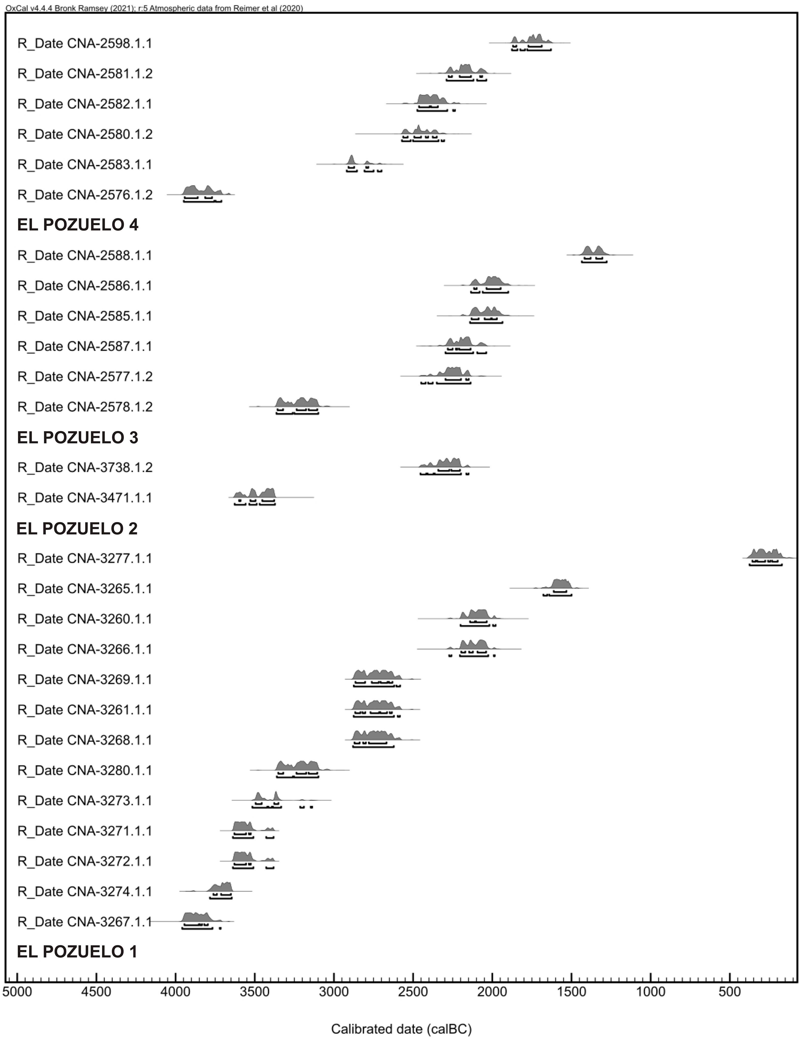
Calibrated radiocarbon dating of the Los Llanetes cluster, El Pozuelo complex (OxCal v.4.4 Bronk Ramsey [Reference Bronk Ramsey2021]; r: 5 IntCal20 atmospheric data from Reimer et al. [Reference Reimer, Austin, Bard, Bayliss, Blackwell, Bronk Ramsey, Butzin, Cheng, Edwards, Friedrich, Grootes, Guilderson, Hajdas, Heaton, Hogg, Hughen, Kromer, Manning, Muscheler, Palmer, Pearson, Van der Plicht, Reimer, Richards, Scott, Southon, Turney, Wacker, Adolphi, Büntgen, Capano, Fahrni, Fogtmann-Schulz, Friedrich, Köhler, Kudsk, Miyake, Olsen, Reinig, Sakamoto, Sookdeo and Talamo2020]).

Calibrated radiocarbon dating of the Los Llanetes cluster: El Pozuelo 1–4 (OxCal v.4.4 Bronk Ramsey [Reference Bronk Ramsey2021]; r:5 IntCal20 atmospheric data from Reimer et al. [Reference Reimer, Austin, Bard, Bayliss, Blackwell, Bronk Ramsey, Butzin, Cheng, Edwards, Friedrich, Grootes, Guilderson, Hajdas, Heaton, Hogg, Hughen, Kromer, Manning, Muscheler, Palmer, Pearson, Van der Plicht, Reimer, Richards, Scott, Southon, Turney, Wacker, Adolphi, Büntgen, Capano, Fahrni, Fogtmann-Schulz, Friedrich, Köhler, Kudsk, Miyake, Olsen, Reinig, Sakamoto, Sookdeo and Talamo2020]).
Bayesian statistics are the best tools to establish the temporality of archaeological sites (Bronk Ramsey Reference Bronk Ramsey2008, Reference Bronk Ramsey2009). Despite the limitations implicit in the method, they are able to establish estimates and precise interpretations of chronological events (Buck et al. Reference Buck, Cavanagh and Litton1996). In the case of megalithic tombs with different processes of building, modification of the structures and a succession of collective burials, the application of Bayesian models can determine the chronology of the building phases, periods of funerary or ritual activity, times of the start and finish of activity, hiatuses or periods of disuse, and the duration of each phase.
Two control parameters must be met to construct robust chronological models. The first is the need for a correct and re-constructible archaeological record. At the Los Llanetes megalithic cluster, the stratigraphic-structural sequence is known exhaustively and the architectural changes in the monuments have been documented precisely. The second is to obtain Bayesian models with high correlation indices in order to reduce the probability intervals of the chronometric distribution of the dates.
The chronological sequence has been created with two Bayesian models using OxCal: models by phases and the probabilistic estimate of the duration of events. Thus, two models of phases have been made according to their stratigraphy, grouping the dates in the construction levels and different areas depending on architectural and/or activity phases. First, a model of phases in Dolmen 1 has been generated, since this is the monument with the largest number of dates for superimposed stratigraphic-structural contexts that has provided dates for all the phases, enabling a robust chronological sequence to be established. Second, a model of phases for the four monuments has been determined using the 26 dates that cover the chronological development of the megalithic group from the Late Neolithic to the Late-Final Bronze Age. The single date in the Iron Age has not been used as it is the only date for this phase and reflects a long discontinuity or hiatus after the older dates and does not provide a temporal range defined by start and finish boundaries.
In both models, correlation indices (Amodel) of above 60% were obtained, as required by Bayesian statistics (Bronk Ramsey Reference Bronk Ramsey1995). These statistical indices confirm the correct correlation of the intervals and probabilistic distribution of the dates with the stratigraphic sequences. This has enabled the determination of the chronological events of construction, transformation and funerary or ritual activity in the megalithic cluster, as well as the temporality and duration of the phases with the chronological boundaries of their start and finish.
The duration of the activity was obtained with the Span function in OxCal (Bronk Ramsey Reference Bronk Ramsey2009) to determine the chronometric time in years of the phases of use of the megalithic structures. Complementary with this, the sum of probabilities (Bronk Ramsey Reference Bronk Ramsey1995, Reference Bronk Ramsey2009) has allowed the intensity and duration of the activity and the presence of hiatuses between the phases to be assessed. Finally, the contemporaneity test (χ 2 test) (Ward and Wilson Reference Ward and Wilson1978) has been performed by combining the three dates for Phase 5 in Dolmen 1 using the Combine function (Bronk Ramsey Reference Bronk Ramsey2009) in order to verify if the activity in this period took place in close, short-duration time intervals.
The complexity of the architectural sequence at the megalithic site, the variety of contexts and uses, the type of sampling and the limited number of dates obtained in the present study mean that we must be prudent in the interpretation of the Bayesian models. It is not feasible to reach definitive inferences about the chronologies owing to the limitations of the study as regards the record itself and the samples that were obtained. The first limitation is the impossibility of obtaining samples to date the full stratigraphic sequence in each tomb, as not all the phases could be dated. The second constraint is the low number of dates obtained corresponding to Prehistory, especially in Dolmen 2, which reduces the potential for the construction of solid Bayesian models and defining the temporal boundaries of the phases and hiatuses more precisely. The third reservation is determined by limitations of the statistical analysis itself, such as the sum of probabilities, because the results of the probabilistic estimates depend on the number of dated samples and the extension taken by the calibration curve (Michczyñski and Michczyñska Reference Michczyñski and Michczyñska2006; William Reference William2012).
The contextualized analysis of the El Pozuelo complex in relation to the diachronic sequence of dolmens in southwest Iberia has been carried out by calibrating the 152 radiocarbon dates, using the sum of probabilities and Bayesian models developed by architectural groups.
Results
The El Pozuelo Dolmens
The series of dates for El Pozuelo 1 has been decisive to establish the chronological sequence of the group. At this monument, 13 dates were obtained for stratigraphic levels and structures that show the building development and part of the activity in the megalithic group. Most of the radiocarbon dating were obtained on samples from the fill of structures and superimposed and unaltered construction levels in which the charcoal had been buried (Figure 7). Thus, dates with very reliable chronometric intervals were obtained for the main phases of the stratigraphic sequence (Figure 7), allowing the reconstruction of their temporality.
Cross-section and elevations of the El Pozuelo 1. Analysis of the stratigraphic-stuctural sequence and location of the radiocarbon dates.
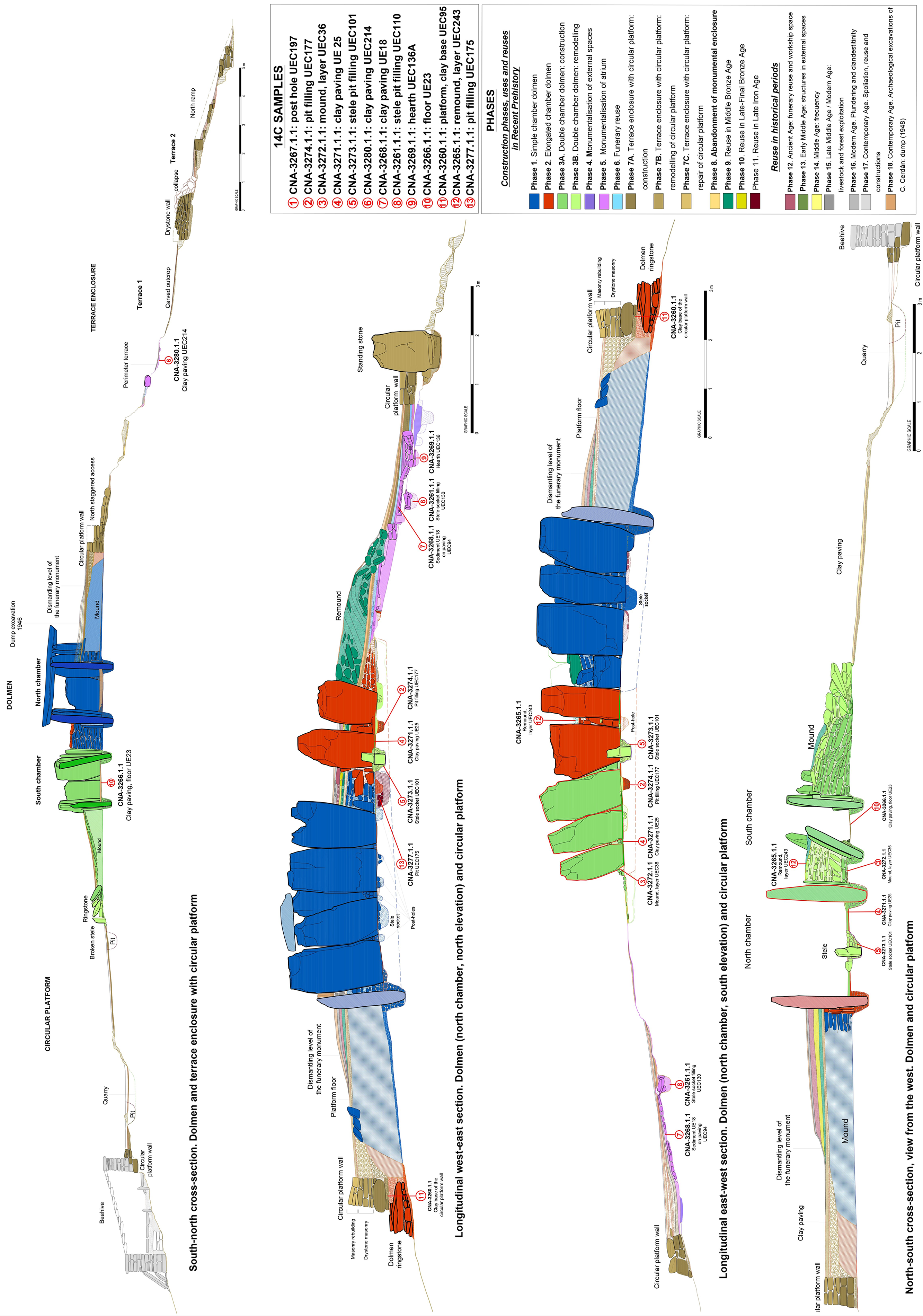
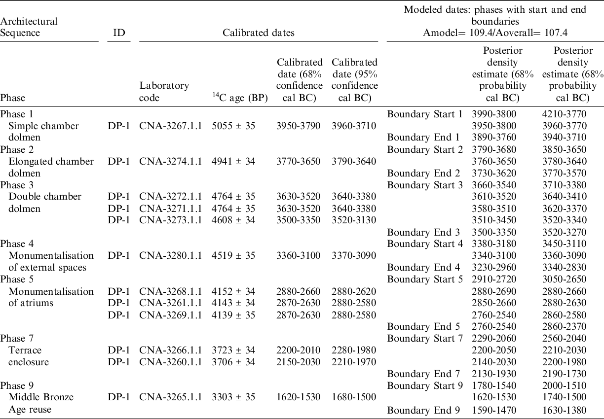
The analysis of the calibrated dates and the Bayesian modeling (Amodel: 109.4%) in relation to the stratigraphy is able to establish the sequence of changes to the monument and delimit the phases (Table 3; Figure 8). The dolmen with the simple chamber (Phase 1) would have been built in an interval of ca. 3960–3770 (95%) or 3950–3800 (68%) cal BC, as shown by the date (CNA-3267.1.1) from a posthole attributed to the use of a wooden tripod or trestle during the construction (Linares-Catela Reference Linares-Catela and Ard2021). Its reconstruction as a dolmen with an elongated chamber (Phase 2) took place soon afterwards: 3780–3640 (95%) or 3760–3650 (68%) cal BC, as shown by the date (CNA-3274.1.1) from the fill in the foundation hole for the axial stele.
Bayesian modeling by phases of El Pozuelo 1, Los Llanetes cluster (OxCal v.4.4 Bronk Ramsey [Reference Bronk Ramsey2021]; r: 5 IntCal20 atmospheric data from Reimer et al. [Reference Reimer, Austin, Bard, Bayliss, Blackwell, Bronk Ramsey, Butzin, Cheng, Edwards, Friedrich, Grootes, Guilderson, Hajdas, Heaton, Hogg, Hughen, Kromer, Manning, Muscheler, Palmer, Pearson, Van der Plicht, Reimer, Richards, Scott, Southon, Turney, Wacker, Adolphi, Büntgen, Capano, Fahrni, Fogtmann-Schulz, Friedrich, Köhler, Kudsk, Miyake, Olsen, Reinig, Sakamoto, Sookdeo and Talamo2020]).
Chronological model of the El Pozuelo 1. Bayesian modeling by phases (OxCal v.4.4 Bronk Ramsey [Reference Bronk Ramsey2021]; r:5 IntCal20 atmospheric data from Reimer et al. [Reference Reimer, Austin, Bard, Bayliss, Blackwell, Bronk Ramsey, Butzin, Cheng, Edwards, Friedrich, Grootes, Guilderson, Hajdas, Heaton, Hogg, Hughen, Kromer, Manning, Muscheler, Palmer, Pearson, Van der Plicht, Reimer, Richards, Scott, Southon, Turney, Wacker, Adolphi, Büntgen, Capano, Fahrni, Fogtmann-Schulz, Friedrich, Köhler, Kudsk, Miyake, Olsen, Reinig, Sakamoto, Sookdeo and Talamo2020]).
The architectural change into a monument with double chambers (Phase 3A) must have occurred in a specific time in the period 3700–3600 cal BC, according to the stratigraphic coherence and homogeneity of the chronometric results for the two dates. Thus, the samples for the two construction levels gave the same result: 4764 ± 35 BP, determining a calibrated age of 3640–3380 (95%) or 3630–3520 (68%). The date (CNA-3272.1.1) came from a layer in the mass of the mound between the two chambers deposited during the reconstruction of the dolmen. The date (CNA-3721.1.1) was obtained in the clay flooring inside the north chamber, which covered the hole that had held the original axial stele.
The stratigraphic sequence showed that work was carried out in the frontal façade, creating an open monumental atrium with two vestibules, as well as repairs to the structure of orthostats in the south chamber and the spatial reorganisation of the north chamber (Phase 3B). During the work in the north chamber, the position of the axial stele was moved. The date (CNA-3273.1.1) of the hole for the foundation of the stele, which cut through the previous clay floor, shows that this was a later event, carried out ca. 3520–3340 (95%) or 3510–3450 (68%).
Several samples from the outer areas provide time ranges that are able to establish the chronology of ritual activity at the site in later chronologies. On one hand, the date for the pavement in the outer perimeter terrace (CNA-3280.1.1) demonstrates that the outer areas were monumentalized ca. 3360–3090 (95%) or 3340–3100 (68%) cal BC (Phase 4). In turn, the three dates from the outer area at the front of the dolmen show that the atrium was intensively used between 2900 and 2600 cal BC, as these dates are very similar obtained for the pavement (CNA-3268.1.), foundation pit of a stele (CNA-3261.1.1) and hearth (CNA-3269.1.). The χ2 test (Acomb 117; df=2 T=0.091(5% 5.991)) of the three dates gives a combined chronometric result of 2880–2630 (95%) or 2870–2660 (68%) (Table S3.1; Figure S3.2). This attests the possible contemporaneity of the dates and the relative short duration of ritual activity in that phase. The use of the area may have been associated with different practices and ceremonies worshipping the ancestors, as indicated by the presence of structures in this area outside the front of the dolmen: hearths, altars, hoard of votive objects, etc.
Two dates have established the chronology of the emergence and conversion of the site into a terraced enclosure with a circular platform in the Early Bronze Age (Phase 7). The first date (CNA-3266.1.1), obtained in the south chamber, marks a reuse event in the chamber in connection with activity in the terraced enclosure: 2280–1980 (95%) or 2200–2010 (68%) cal BC. The second date (CNA-3260.1.1), from the base of the clay foundation of the wall in the upper platform, situates its construction and the monumentalization of the enclosure in a slightly later time: 2200–1980 (95%) or 2140–2030 (68%) cal BC.
Two dates have been obtained for later contexts and phases of reuse. One of them (CNA-3265.1.1) corresponds to changes to the mound following the partial emptying of the north chamber in the Middle Bronze Age (Phase 9), ca. 1680–1500 cal BC (95%). The other (CNA-3277.1.1) reflects a short-duration reuse event in the Late Iron Age (Phase 10), ca. 380–170 cal BC (95%).
A smaller number of dates have been obtained for the other three dolmens. They correspond to specific stratigraphic phases but are unable to reconstruct the full chronological sequence. Nonetheless, these 14 dates complement the series of dates for this megalithic cluster.
Only two prehistoric dates were obtained for El Pozuelo 2. One (CNA-3471.1.1) comes from the clay level at the base of the southern side of the mound, arranged as the first construction level of the dolmen with double clambers. Its chronometric result suggests that the rebuilding of the monument may have taken place ca. 3630–3370 cal BC (95%), with the construction of the south chamber and the enlargement of the mound. The other, which is more recent, correlates with the funerary reuse of the south chamber ca. 2460–2150 cal BC (95%), an episode prior to the probable construction of the tholos and the surrounding ditched enclosure.
In El Pozuelo 3, the six radiocarbon dates correspond to four different phases. The earliest date (CNA-2578.1.2), from the deliberate backfilling of the pit after the removal of the axial stelae from the north chamber, correlates with the reconstruction work on the monument as a large dolmen with double chambers, which probably took place ca. 3370–3090 cal BC (95%). Another date (CNA-2577.1.2) marks the last episode of the funerary and votive use as a collective burial ca. 2450–2130 cal BC (95%). Three dates (CNA 2587.1.1, CNA 2585.1.1, and CNA 2586.1.1) demonstrate the temporality of activity inside the dolmen during the time of the terraced enclosure, in the last quarter of the third millennium cal BC. The last date (CNA-2588.1.1) is correlated with the occasional reuse of the monument in the Late Bronze Age, ca. 1440–1270 cal BC (95%).
Five radiocarbon dates, corresponding to four phases, were obtained for El Pozuelo 4. The oldest (CNA-2576.1.2), from the base of the mound, indicates a terminus post quem for the construction of the dolmen with a simple chamber ca. 3950–3710 cal BC (95%). Another date (CNA-2583.1.1) from the floor of the atrium, is associated with the reforms to the access to the monument, consisting of placing a stele and a quadrangular altar and laying a pavement, which would have occurred between 2920 and 2700 (95%) cal BC. Two dates (CNA-2580.1.2 and CNA-2582.1.2) situate the funerary reuse between 2600–2200 cal BC (95%). The date CNA-2581.1.2, obtained in the fill of the holes left when the pillars were removed from the chamber, date the dismantling of the structure ca. 2290–2030 cal BC (95%), when the terraced enclosure was built.
A radiocarbon date (CNA-2598.21.1) from the floor of Terrace 2, to the west of Dolmen 4, may be related to the abandonment of the monumental enclosure, which probably took place ca. 1880–1630 cal BC (95%).
The Los Llanetes Cluster
The stratigraphic study and joint analysis of the dates for the four monuments is able to trace out the chronological sequence of the megalithic cluster. In this regard, the development of the Bayesian modeling by phases and the model of the sum of probabilities establish probabilistic estimates for the duration and start and end boundaries of each phase (Tables 4 and 5; Figures 9 and 10) and architectural model (Figure 11).
Bayesian modeling by phases of the Los Llanetes cluster, El Pozuelo complex (OxCal v.4.4 Bronk Ramsey [Reference Bronk Ramsey2021]; r:5 IntCal20 atmospheric data from Reimer et al. [Reference Reimer, Austin, Bard, Bayliss, Blackwell, Bronk Ramsey, Butzin, Cheng, Edwards, Friedrich, Grootes, Guilderson, Hajdas, Heaton, Hogg, Hughen, Kromer, Manning, Muscheler, Palmer, Pearson, Van der Plicht, Reimer, Richards, Scott, Southon, Turney, Wacker, Adolphi, Büntgen, Capano, Fahrni, Fogtmann-Schulz, Friedrich, Köhler, Kudsk, Miyake, Olsen, Reinig, Sakamoto, Sookdeo and Talamo2020]).

Duration of activity in the Los Llanetes cluster in the Later Prehistory, according to probabilistic estimates from Bayesian modeling (OxCal v.4.4.2 Bronk Ramsey [Reference Bronk Ramsey2021]; r:5 IntCal20 atmospheric data from Reimer et al. [Reference Reimer, Austin, Bard, Bayliss, Blackwell, Bronk Ramsey, Butzin, Cheng, Edwards, Friedrich, Grootes, Guilderson, Hajdas, Heaton, Hogg, Hughen, Kromer, Manning, Muscheler, Palmer, Pearson, Van der Plicht, Reimer, Richards, Scott, Southon, Turney, Wacker, Adolphi, Büntgen, Capano, Fahrni, Fogtmann-Schulz, Friedrich, Köhler, Kudsk, Miyake, Olsen, Reinig, Sakamoto, Sookdeo and Talamo2020]).

Chronological model of the Los Llanetes cluster, El Pozuelo complex. Bayesian modeling by phases (OxCal v.4.4 Bronk Ramsey [Reference Bronk Ramsey2021]; r:5 IntCal20 atmospheric data from Reimer et al. [Reference Reimer, Austin, Bard, Bayliss, Blackwell, Bronk Ramsey, Butzin, Cheng, Edwards, Friedrich, Grootes, Guilderson, Hajdas, Heaton, Hogg, Hughen, Kromer, Manning, Muscheler, Palmer, Pearson, Van der Plicht, Reimer, Richards, Scott, Southon, Turney, Wacker, Adolphi, Büntgen, Capano, Fahrni, Fogtmann-Schulz, Friedrich, Köhler, Kudsk, Miyake, Olsen, Reinig, Sakamoto, Sookdeo and Talamo2020]).
The megalithic cluster is noteworthy for the long duration of its use, in which building work and discontinuous activity has been established for the period between the early fourth millennium to the early second millennium cal BC, in addition to different reuse actions during the second millennium cal BC (Figure 10). The full duration of activity covers the period of ca. 4050–1120 (95%) or 3970–1270 (68%), with an estimated complete length of 2380 to 2850 years (Table 5).
Sum of probabilities of the Los Llanetes radiocarbon determinations (n: 26): (a) calibrated dates; (b) modeled dates.
The necropolis of Los Llanetes began with the construction of the single chamber dolmens in the early fourth millennium cal BC, as shown by the two modeled dates for Dolmens 1 and 4, with very close chronometric results. It is highly likely that Phase 1 took place ca. 4050–3710 (95%) or 3970–3760 (68%), with a maximum duration of 90 years. Therefore, the single chamber dolmens may have been built during a short length of time, in a building phase and a use of less than a century, during the first two centuries of the fourth millennium cal BC. However, some evidence suggests a possible greater antiquity of the megalithic site. First, recycled steles have been documented in the chambers, mostly reused as headstones. Second, pits and/or steles-pillars have been recorded on the central axis, as in Dolmen 4, and these may correspond to previous alignments of standing-stones that conditioned the design of the dolmens. This corresponds to the Late Neolithic (4200–3600 cal BC) in the southern Iberia sequence.
Phase 2 corresponds to the construction of dolmens with an elongated chamber. Only one date has been obtained, from Dolmen 1, situated in the third and fourth centuries of the fourth millennium cal BC. The process could be extended to the other monuments. It is plausible that the dolmens were converted into elongated monuments ca. 3850–3540 (95%) or 3790–3620 (68%). The architectural projects of lengthening the chambers and enlarging the mounds in this phase may have taken place in a relatively short period of time.
Phase 3 was the time of the most intense building and funerary activity in the cluster, as shown by the study of the stratigraphic-structural sequence, the five dates obtained and grave goods documented, most of which can be attributed to the chrono-cultural period of the Final Neolithic (3600–3300/3200 cal BC) in the south of the Iberian Peninsula. The double chamber dolmens were built in this time over the older architectures and the façades of the dolmens were monumentalized. This phase took place ca. 3710–3170 (95%) or 3660–3260 (68%), with a probable maximum duration of 360 years, within the second third of the fourth millennium cal BC. During the three centuries, each monument underwent its own building sequence with a specific temporality.
The oldest dates come from Dolmen 1, marking the emergence of monuments with multiple chambers. The two dates for construction levels show that the conversion into a dolmen with parallel double chambers with independent accesses may have occurred ca. 3640–3380 (95%) or 3620–3520 (68%). In a later time, ca. 3510–3330 (95%) or 3490–3350 (68%), a series of remodeling works were carried out: the façade was refurbished, the axial stele was moved, the north chamber was repaved and the north wall of orthostats in the south chamber was repaired.
Monuments 2 and 3 may have been reconstructed as dolmens with multiple chambers later. Dolmen 2, with perpendicular double chambers, was reformed in the middle of the fourth millennium, ca. 3540–3360 (95%) or 3530–3370 (68%). Dolmen 3 was probably rebuilt with parallel chambers, antechamber, and convergent passage at the start of the last third of the fourth millennium, ca. 3490–3220 (95%) or 3370–3320 (68%).
In the case of Dolmen 4, it is likely that the open passage was built, the mound was enlarged and the stepped access was carved into the bedrock in the second half of the fourth millennium BC. These works meant that the monument was converted into a segmented covered gallery with an open part, the passage, and a covered space with two sectors separated by the transversal slab: antechamber and chamber with central pillars.
Phase 4 corresponds to the time of the first outer structures, such as the paved perimeter terrace on the north side of Dolmen 1, where the radiocarbon dates indicate activity in this area in the last third of the fourth millennium cal BC: 3310–3030 (95%) or 3220–3100 (68%).
After this time, a period of disuse or apparent inactivity at the turn of the fourth to the third millennia cal BC may have lasted about two centuries, as shown by the graphs with the sum of probabilities (Figure 10). This hiatus coincides with the emergence of complex societies in the Early Copper Age (3300/3200–2900 cal BC) in the southern Iberian Peninsula, when new ideological and social patterns were introduced. In the funerary sphere, new collective burials were developed, such a hypogea with passages and circular chambers, and new architectural models appear, like the tholoi (Lozano Medina and Aranda Jiménez Reference Lozano Medina and Aranda Jiménez2017; Aranda Jiménez et al. Reference Aranda Jiménez and Milesi García2021).
The dates indicate that activity restarted at the site in the first third of the third millennium cal BC, at the time of the Middle Copper Age (2900–2600 cal BC). Phase 5 represents the building of structures outside the front of the dolmens, where the atria were monumentalized. This occurred in the time of ca. 3060–2510 (95%) or 2980–2580 (68%), with an estimated maximum duration of 260 years. To be precise, the radiocarbon results suggest that the activity took place in two cycles of short duration. In Dolmen 4, the reform of the access and the position of the stele may have occurred in a specific interval of ca. 2920–2700 (95%). In Dolmen 1, the three combined dates attest the contemporaneity and short duration of activity in this phase, between 2880–2630 (95%).
After another hiatus of at least a century in the middle of the third millennium cal BC, the interior of the dolmens were used once more (Phase 6). Dates from Dolmens 2, 3, and 4 situate this phase at the end of the second third of the third millennium, ca. 2650–2140 (95%) or 2530–2180 (68%). It cannot be determined whether the funerary activity was continuous or, more probably, took place in occasional episodes, as suggested by the few grave goods belonging to that time. The dates for this phase are affected by the limitations of calibrated radiocarbon dating, as the curve intersects long temporal ranges. It is thus plausible that a short period of disuse followed this phase.
Activity restarted in the last three centuries of the third millennium and the first century of the second millennium cal BC, in the chrono-cultural period of the Early Bronze Age in south Iberia. The six modeled dates for Phase 7 establish its boundaries ca. 2290–1880 (95%) or 2230–1940 (68%), with a probable maximum duration of 250 years. The terraced enclosures with circular platforms emerged in the phase. This new form of monument was based on the re-appropriation of the place of the ancestors and the deliberate partial dismantling and recycling of the materials in the dolmens to create large open-air stepped structures that were prominent in the landscape. These monuments were built with reused materials from the dolmens. They consist of two or three levels of terracing around the dolmens, delimited by drystone walls, access ramps and even structures around the dolmens, like the circular platform around Dolmen 1. The old funerary monuments were integrated as architectural elements, like large open stone skeletons, while their interior areas were reused.
The enclosure around Dolmen 1 consists of a circular stone platform on the top level, with several stepped accesses and a ramp, and two terraces on a lower level. The two dates place the construction of the enclosure in the 22nd–21st centuries cal BC. The two surrounding terraces may be slightly older, as their alignment and design are different from the platform, and also because of the older dates obtained for similar contexts in Dolmens 3 and 4.
The enclosure around Dolmens 3 and 4 might have been built during the second half of the 23rd century cal BC, as suggested by the first two dates for this phase. Three dates for the interior of Dolmen 3 reveal the continuity of activity in these monumental enclosures during the transition from the third to the second millennia cal BC.
Phase 8, the abandonment of the monumental enclosures, must have taken place in the second century in the second millennium cal BC, probably in the interval of ca. 1880–1640 (95%) or 1880–1690 (68%).
The monuments were reused later in the Bronze Age, in two phases separated by long hiatuses or discontinuities that confirm a more sporadic or occasional use of the site. Phase 9 corresponds to a short event in El Pozuelo 1 in the Middle Bronze Age, when the mound was rebuilt, and the north chamber was partially emptied in the middle centuries of the second millennium cal BC: 1670–1490 (95%). Phase 10 is correlated with the presence of ditches with or without a pavement and possible steles in the mound of Dolmen 1 and the space between Dolmens 3 and 4, ca. 1440–1280 (95%).
Diabase hammers with a central groove, identical to those found in the proximate copper mines at Chinflón have been found in the stratigraphic levels and structures associated with both phases. Therefore, the reoccupation of the monuments for activities and the restart of practices might be related to mining work, although at the moment no coetaneous dates have been obtained at Los Llanetes. Four radiocarbon dates define the temporality of the two occupation phases of that site (Rothenberg and Blanco Freijeiro Reference Rothenberg, Blanco Freijeiro and Craddock1980; Burleigh et al. Reference Burleigh, Matthews and Ambers1982) (Table S4.1; Figure S4.2). The first must have taken place in the second third of the second millennium cal BC, in the Middle Bronze Age: ca. 1700–1400 (95%). The second phase was the time of most intense mining activity and occupation of the settlement, in the Late Bronze Age: ca. 1200–700 (95%).
After that time, a long hiatus is seen in the use of the monuments. Only sporadic visits to the site have been recorded in the Late Iron Age, between the 4th–2nd centuries cal BC.
Discussion
The chronological data obtained at El Pozuelo acquire greater value in the context of the architectural sequences and dynamics of use of dolmens in southwest Iberia. This new information changes certain conceptions about the genesis of the first funerary monumentality and at the same time support the diachronic sequence of megalithism in the region. The establishment of the architectural sequence of the Los Llanetes group and the dating of the different architectural types has served to verify the greater antiquity of the simple chamber dolmens, to establish the temporality of formation, appearance, and transformation of the other funerary monuments (elongated chamber dolmens, covered galleries and multiple chamber dolmens) and attest to the permanence of the megalithic monumentality during the Early Bronze Age. Thus, the contextualized study of the results compared with dates obtained at analogous monuments is able to suggest several aspects for discussion and propose new interpretations about the emergence, consolidation, diversification, reuse and abandonment of dolmens in Later Prehistory.
The recent study of the Campo de Hockey necropolis with protomegalithic tombs proposes the beginning of funerary megalithism on the Atlantic Coast in relation to the maritime distribution networks of exotic goods from 4300 cal BC (Vijande-Vila et al. Reference Vijande-Vila, Díaz-Zorita Bonilla, Morell-Rovira, Olalde, Sánchez-Barba Muñoz, Domínguez-Bella, Emslie, Becerra-Martín, Rubio-Salvador and Fernández-Sánchez2022). Dolmens with access from outside appear in the Iberian southwest at the beginning of the fourth millennium cal BC, synchronically with other funerary monuments in different parts of western Europe, including the northwest of the Iberian Peninsula and the British Isles (Schulz Paulsson Reference Schulz Paulsson2017). A study of the radiocarbon dates has posited that the spread of the megalithic phenomenon across the Atlantic seaboard of Europe occurred by maritime routes, through an expansion from northwest France, where megalithic tombs have been dated to the second half of the fifth millennium cal BC, to the other areas (Schulz Paulsson Reference Schulz Paulsson2019). This expansion process coincides with the 5.9 kyr climatic event, which brought an abrupt and widespread climate change in Europe from humidit to dry conditions and intense aridity in several regions (Wang et al. Reference Wang, Ge, Wang, Wen and Huang2013). This consequently must have caused transformations in the different spheres of Neolithic societies.
This phenomenon of temporal convergence and the simultaneous emergence of megalithic monuments in the various regions has been interpreted in different ways. Radiocarbon dates in southwest Iberia prior to this study demonstrate that the spread of funerary megalithism is related to the emergence of collective mortuary practices in that region around 3800 cal BC, resulting in the appearance of new funerary architectures, morturary rituals, and dynamics of burial functions (Carvalho and Cardoso Reference Carvalho and Cardoso2015). However, this process cannot be directly correlated with a demographic increase and the consolidation of agricultural societies with intensive economic systems, as has been traditionally held. In fact, recent studies suggest that during the expansion of megalithism in southern Portugal there may have been a decrease in population (Pardo-Gordó and Carvalho Reference Pardo-Gordó and Carvalho2020). In this sense, it has been interpreted that these communities developed an extensive economic system based on a model of mobile exploitation of the territory through ovicaprid livestock farming (Carvalho Reference Carvalho2015).
The chronological analysis will be performed with the dates from El Pozuelo and with the radiocarbon dataset published for the dolmens in the Iberian southwest (Table 6; Figure 12). These Bayesian tests have excluded 9 radiocarbon dates from levels beneath the mounds, as these mostly belong to previous Neolithic phases of occupation, in which dwellings, hearths and/or domestic objects have been documented, as in the case of the dolmens of Tremedal (Ruiz Gálvez Reference Ruiz Gálvez and Jiménez Ávila2000), Cabeçuda 1 (Oliveira Reference Oliveira and Balbín Berhmann1997a), Castelhanas (Rocha Reference Rocha2020), Figueira Branca (Oliveira Reference Oliveira1997b), Azután (Bueno Ramírez et al. Reference Bueno Ramírez, Barroso Bermejo, Balbín Behrman, Campo Martín, Etxeberría Gabilondo, González Martín, Herrasti Erlogorri, Juan Treserras, López García, López Sáez, Matamala and Sánchez2002, Reference Bueno Ramírez, Balbín Berhmann and Barroso Bermejo2005), Joaniña (Oliveira Reference Oliveira and Balbín Berhmann1997a), Alberite (Ramos Muñoz and Giles Pacheco Reference Ramos Muñoz and Giles Pacheco1996) and Casas de Don Pedro (Gavilán Ceballos and Más Cornella Reference Gavilán Ceballos and Mas Cornellá2021) (Table S2).
Radiocarbon dating of dolmens from the southwest of the Iberian Peninsula. Samples analyzed in this study: 152 dates, 66 sites. Calibrated dating by OxCal v.4.4 Bronk Ramsey (Reference Bronk Ramsey2021); r: 5 IntCal20 atmospheric data from Reimer et al. (Reference Reimer, Austin, Bard, Bayliss, Blackwell, Bronk Ramsey, Butzin, Cheng, Edwards, Friedrich, Grootes, Guilderson, Hajdas, Heaton, Hogg, Hughen, Kromer, Manning, Muscheler, Palmer, Pearson, Van der Plicht, Reimer, Richards, Scott, Southon, Turney, Wacker, Adolphi, Büntgen, Capano, Fahrni, Fogtmann-Schulz, Friedrich, Köhler, Kudsk, Miyake, Olsen, Reinig, Sakamoto, Sookdeo and Talamo2020).
Architectural sequence and temporality of the Los Llanetes cluster in Later Prehistory. Chronologies and radiocarbon dates expressed at 68% of probability (1σ).

Dolmens with radiocarbon dates in the Iberian southwest. Architectural groups and chronologies of emergence.

The 152 dates have been analyzed and presented in accordance with the 95% confidence (2σ). They have been placed in architectural groups to carry out the sum of probabilities and the Bayesian models of protomegalithic tombs, dolmens (passage graves, simple chambers, elongated chambers and covered galleries, multiple chambers) and megalithic cists. This has enabled the duration of the activity of the different architectural types (Figure 13) to be observed in addition to identifying the temporalities of the construction, funerary activity, reuse, etc.
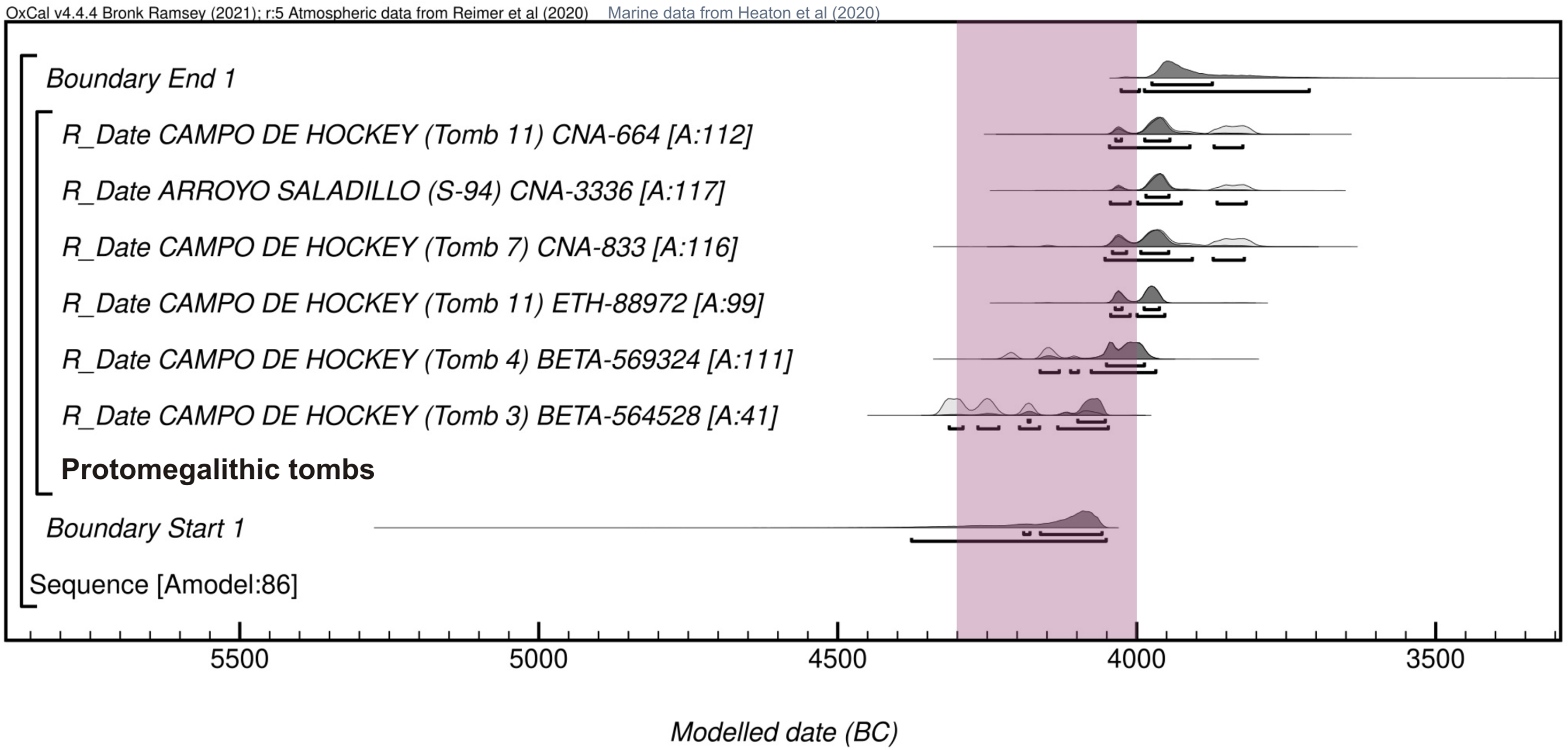
Sum of probabilities of the dolmens in the Iberian southwest: (a) in total (152 dates). By architectural groups: (b) protomegalithic tombs (n: 6); (c) passage graves (n: 75); (d) simple chamber dolmens (n: 12); (e) elongated chamber dolmens/covered galleries (n: 30); (f) multiple chamber dolmens (n: 25); (g) megalithic cists (n: 4).

Protomegalithic Tombs
In the current state of our knowledge, the first funerary monuments built with stone in the southwest of the Iberian Peninsula seem to have been the protomegalithic tombs, found in southern Portugal and western Andalusia. The six dates obtained at the necropolis of the Campo de Hockey and Arroyo Saladillo, associated with settlements, range from the last third of the fifth millennium to the first two centuries in the fourth millennium cal BC (ca. 4300–3800 cal BC) (Figures 13b and 14). These are small structures with a chamber or interior pits without an outer access, covered by circular mounds formed by stone slabs, 2 or 2.50 m in diameter, which precede megalithic monuments. Tomb 11 at the Campo de Hockey, a pit covered by a mound delimited by a perimeter ditch, dated in 4060–3950 and 4036–3669 cal BC, contained the remains of two individuals and occupied the central place in the necropolis. Eleven individual or double burials were arranged around it. Tomb 3 was a covered pit formed by large and middle size stones, dated in 4335–4070 cal BC. Tomb 4 was a pit dug into a platform closed on its northern side by two large stone slabs, dated in 4045–3820 cal BC. Tomb 7 was a cist with an individual burial dated in 4060–3665 cal BC (Vijande Vila Reference Vijande Vila2009; Vijande-Vila et al. Reference Vijande-Vila, Domínguez-Bella, Cantillo Duarte, Martínez López and Barrena Tocino2015, Reference Vijande-Vila, Díaz-Zorita Bonilla, Morell-Rovira, Olalde, Sánchez-Barba Muñoz, Domínguez-Bella, Emslie, Becerra-Martín, Rubio-Salvador and Fernández-Sánchez2022). At Arroyo Saladillo, four pits were covered by a stone slab and a small mound. The individual burial S-94 was dated in 4040–3800 cal BC (García Sanjuán et al. Reference García Sanjuán, Fernández Rodríguez, Balsera Nieto, Mora Molina, Cisneros García, Rodríguez Ariza, Lozano Rodríguez, Pérez Díaz, Luelmo Lautenschlaeger and López Sáez2020).
Bayesian modeling of the protomegalithic tombs in Iberian southwest. Purple stripe: emergence chronology (OxCal v.4.4 Bronk Ramsey [Reference Bronk Ramsey2021]; r:5 IntCal20 atmospheric data from Reimer et al. [Reference Reimer, Austin, Bard, Bayliss, Blackwell, Bronk Ramsey, Butzin, Cheng, Edwards, Friedrich, Grootes, Guilderson, Hajdas, Heaton, Hogg, Hughen, Kromer, Manning, Muscheler, Palmer, Pearson, Van der Plicht, Reimer, Richards, Scott, Southon, Turney, Wacker, Adolphi, Büntgen, Capano, Fahrni, Fogtmann-Schulz, Friedrich, Köhler, Kudsk, Miyake, Olsen, Reinig, Sakamoto, Sookdeo and Talamo2020] and Heaton et al. [Reference Heaton, Köhler, Butzin, Bard, Reimer, Austin, Bronk Ramsey, Grootes, Hughen and Kromer2020]).
Dolmens
At a slightly later time, from the beginning of the fourth millennium BC, dolmens with a system of access from outside functioned as collective tombs. They possessed a method of closing them to guarantee access, the preservation of the remains and continuity of burials.
Passage Graves
Most dates in southwest Iberia correspond to these passage graves, as 36 sites have provided 75 radiocarbon determinations (Figures 13c and 15). These monuments differ in their form, building techniques and chronology depending on the region. The oldest dates have been obtained in the dolmens in the middle Tagus basin, where they may have been built from the early fourth millennium cal BC, as at Azután, ca. 4050–3640 (Bueno Ramírez Reference Bueno Ramírez1991; Bueno Ramírez et al. Reference Bueno Ramírez, Balbín Berhmann and Barroso Bermejo2005) and Tremedal, ca. 3950–3650 (Ruiz Gálvez Reference Ruiz Gálvez and Jiménez Ávila2000).
Bayesian modeling of the passage graves in Iberian southwest. Yellow stripe: emergence chronology (OxCal v.4.4 Bronk Ramsey [Reference Bronk Ramsey2021]; r:5 IntCal20 atmospheric data from Reimer et al. [Reference Reimer, Austin, Bard, Bayliss, Blackwell, Bronk Ramsey, Butzin, Cheng, Edwards, Friedrich, Grootes, Guilderson, Hajdas, Heaton, Hogg, Hughen, Kromer, Manning, Muscheler, Palmer, Pearson, Van der Plicht, Reimer, Richards, Scott, Southon, Turney, Wacker, Adolphi, Büntgen, Capano, Fahrni, Fogtmann-Schulz, Friedrich, Köhler, Kudsk, Miyake, Olsen, Reinig, Sakamoto, Sookdeo and Talamo2020]). (Please see online version for color figures.)

Most of the dated passage graves are in Portugal, in Alentejo and Estremadura, where they are called antas. The first phase of activity took place ca. 3750–3030 cal BC (Boaventura Reference Boaventura and García Sanjuán2011), at the same time as other forms of collective burials: small antas, hypogea, corbelled tombs, pits, and burial caves (Boaventura and Mataloto Reference Boaventura and Mataloto2013). A large part of the dates are concentrated in that period, reflecting the generalisation and territorial expansion of those constructions. The oldest dates come from antas with a polygonal chamber and short passage, which originated in the second quarter of the fourth millennium, in about 3750 cal BC, as at Pedras Grandes (Boaventura Reference Boaventura2009; Silva et al. Reference Silva, Catarina Sousa and Scarre2021) and Carrascal (Boaventura Reference Boaventura2009; Silva et al. Reference Silva, Sousa, Boaventura and Scarre2019) in the Lisbon region, and Cabeceira 4 (Rocha Reference Rocha2005; Carvalho and Rocha Reference Carvalho and Rocha2016) in central Alentejo. The large antas with a polygonal chamber and longer passage have yielded slightly later dates, mostly in the middle or last third of the fourth millennium cal BC, as demonstrated by the antas of Pedra Branca (Soares Reference Soares2010), Currais do Galhordas (Monteiro Rodrigues and Oliveira Reference Monteiro Rodrigues, Oliveira and Senna-Martinez2018), Horta (Oliveira Reference Oliveira2006), Bola da Cera (Monge Soares and Peixoto Cabral Reference Monge Soares and Peixoto Cabral1993; Oliveira Reference Oliveira1997b), Pardais 3 (Valera and Pereiro Reference Emslie, Silva, Valera, Vijande Vila, Melo, Curate, Fidalgo, Inácio, Molina Moreno, Cambra-Moo, González Martín, Barroso-Bermejo, Montero Artús and García Sanjuán2022), Santa Margarida 2 (Gonçalves Reference Gonçalves2001), Trigache 4 and Arruda (Boaventura Reference Boaventura2009). Intense collective funerary activity has been documented in all of them although some of them might correspond to mortuary events with a short duration.
The medium-sized antas and the large ones with a polygonal chamber and long passage continued to be built and used for sustained funerary activity in the first half of the third millennium cal BC, as indicated by the dates at Santa Margarida 3 (Gonçalves Reference Gonçalves2003a), Serrinha (Rocha and Morgado Reference Rocha and Morgado2020), Coureleiros 4 (Oliveira Reference Oliveira1997b), Pardais 3 (Valera and Pereiro Reference Emslie, Silva, Valera, Vijande Vila, Melo, Curate, Fidalgo, Inácio, Molina Moreno, Cambra-Moo, González Martín, Barroso-Bermejo, Montero Artús and García Sanjuán2022), Horta (Oliveira Reference Oliveira2006), Estanque (Rocha Reference Rocha2005; Rocha and Duarte Reference Rocha, Duarte and Polo2009) and Pedra Branca (Soares Reference Soares2010) in Alentejo and at several dolmens in the Lisbon region: Trigache 2, Casal do Penedo, Carcavelos, Estria, Pedra dos Mouros, Casainhos and Pedras da Granja (Boaventura Reference Boaventura2009). In Spain, analogous chronologies have been recorded at the dolmen of Viera (Ferrer Palma et al. Reference Fernández Ruiz, Marqués Merelo, Ferrer Palma, Baldomero Navarro and Balbín Berhmann1997; Aranda Jiménez et al. Reference Aranda Jiménez, García Sanjuán, Lozano Medina and Costa Caramé2013) and Tesorillo de la Llaná (Fernández Ruiz and Márquez Romero Reference Fernández Ruiz and Márquez Romero2008; Márquez Romero et al. Reference Márquez Romero, Fernández Ruiz and Mata Vivar2009). Indeed, as many as a third of all the dates lie within that chronology, corresponding to the high density of funerary activity in the Chalcolithic. These tombs were reused in the second half of the third millennium cal BC. A first cluster of dates is concentrated in the third quarter, correlated with inhumations with grave goods or votive deposits consisting of Late Copper Age and/or Bell Beaker materials, like those dated in the dolmens of Currais do Galhordas (Monteiro Rodrigues and Oliveira Reference Monteiro Rodrigues, Oliveira and Senna-Martinez2018), Anta Grande de Zambujeiro (Soares and Silva Reference Soares and Silva2010), Cebolinhos 2 (Gonçalves Reference Gonçalves2003b), Pardais 3 (Valera and Pereiro Reference Emslie, Silva, Valera, Vijande Vila, Melo, Curate, Fidalgo, Inácio, Molina Moreno, Cambra-Moo, González Martín, Barroso-Bermejo, Montero Artús and García Sanjuán2022), and Pedra Escorregadia (Gomes Reference Gomes1994). A second cluster corresponds to the last quarter of the third millennium and first two centuries of the second millennium cal BC. These were mostly obtained for representative Early Bronze Age individual burials or deposits, such as Santa Margarida 3 (Gonçalves Reference Gonçalves2003a), Nª Sra. Conceiçao dos Olivais (Rocha and Duarte Reference Rocha, Duarte and Polo2009), Cabeçuda 1 (Oliveira Reference Oliveira and Balbín Berhmann1997a) and Tapado do Castelo (Rocha Reference Rocha2021).The funerary reuse of passage graves continued during the period, as Middle Bronze Age individual burials have been dated to between 1700–1400 cal BC at the sites of Barrocal das Freiras 3 (Rocha and Duarte Reference Rocha, Duarte and Polo2009), Currais do Galhordas (Monteiro Rodrigues and Oliveira Reference Monteiro Rodrigues, Oliveira and Senna-Martinez2018), Tesorillo de la Llaná (Fernández Ruiz and Márquez Romero Reference Fernández Ruiz and Márquez Romero2008; Márquez Romero et al. Reference Márquez Romero, Fernández Ruiz and Mata Vivar2009) and Castelhanas (Rocha Reference Rocha2020).
Simple Chamber Dolmens
Dolmens with a simple chamber are characterized by the relative small size of the mounds and the diverse shapes of the chambers (trapezoid, pseudo-oval, rectangular, etc.), the small burial area and a front access system. They had traditionally been considered the oldest monuments, based on the morphological simplicity and lesser technical complexity. Few sites have been dated with which to explore exhaustively the origin and duration of this type of funerary construction. Eleven sites have provided 12 dates (Figures 13d and 16), which limits the development of a robust diachronic sequence.
Bayesian modeling of the simple chamber dolmens in Iberian southwest. Red stripe: emergence chronology (OxCal v.4.4 Bronk Ramsey [Reference Bronk Ramsey2021]; r:5 IntCal20 atmospheric data from Reimer et al. [Reference Reimer, Austin, Bard, Bayliss, Blackwell, Bronk Ramsey, Butzin, Cheng, Edwards, Friedrich, Grootes, Guilderson, Hajdas, Heaton, Hogg, Hughen, Kromer, Manning, Muscheler, Palmer, Pearson, Van der Plicht, Reimer, Richards, Scott, Southon, Turney, Wacker, Adolphi, Büntgen, Capano, Fahrni, Fogtmann-Schulz, Friedrich, Köhler, Kudsk, Miyake, Olsen, Reinig, Sakamoto, Sookdeo and Talamo2020]).

The two dates at Los Llanetes (El Pozuelo 1 and 4) are quite coherent, as they situate the appearance and development of simple chamber dolmens in the first two centuries of the fourth millennium cal BC, ca. 4050–3710 (95%) or 3970–3760 (68%). These are currently the oldest dates for simple chamber dolmens in southwest Iberia and probably mark the origin of these megalithic funerary monuments in western Andalusia. These dolmens are characterized by elongated oval chambers with axial steles or central pillars, from 3.5 to 6.75 m long, with maximum widths of 1.70 to 2.60 m and heights varying from 1.50 to 2.10 m. They were built with orthostats consisting of a headstone and symmetrical curved walls, formed by stones fitted vertically in deep foundation trenches. They were inside circular or oval mounds with a maximum diameter of between 9 and 14.5 m, whose orientation and main axis of symmetry is towards the southeast.
Simple chamber dolmens are common in other parts of the southwest of the Iberian Peninsula, like Alentejo. The dates for levels under the mounds at Vale de Rodrigo 3, ca. 3950–3650 cal BC (Armbruester Reference Armbruester2006) and Vale Rodrigo 2, ca. 3940–3520 cal BC (Larsson Reference Larsson2000), establish a terminus post quem, after which the monuments were built. In this regard, it has been proposed that these dates of Vale Rodrigo group mark the initial time of the construction of the first megalithic tombs in the region and 3700 cal BC has been established as the time of the emergence of funerary megalithism (Boaventura Reference Boaventura and García Sanjuán2011; Boaventura and Mataloto Reference Boaventura and Mataloto2013). The similarity in the form of the Vale Rodrigo dolmens and the first phase at El Pozuelo is clear, as they are constructions with trapezoid or oblong chambers with a central pillar or stele, up to 8 m long, 3 m wide and 2.5 m high, inside circular mounds (Kalb Reference Kalb2013). However, the dates for the dolmens of the first phase at Los Llanetes indicates that they are probably one or two centuries older than the Alentejo dolmens, marking the emergence of the simple chamber monuments in the Iberian southwest ca. 3950 cal BC.
Small antas with chambers (rectangular, trapezoid, circular, polygonal, oblong and oval) between 1 and 3 m long inside mounds of variable diameters (4-10 m), with or without a kerb, are also common in Alentejo. The two radiocarbon dates available for Sobreira 1, ca. 3650–3380 cal BC (Boaventura et al. Reference Boaventura, Ferreira and Silva2013), and Cabeço de Areia, ca. 3630–3340 cal BC (Rocha Reference Rocha2005), support the expansion of this architectural model in the second third of the fourth millennium. It has therefore been proposed that the main period for the construction and funerary use of the small Alentejo antas occurred in the Late Neolithic, between 3700 and 3300 cal BC (Mataloto et al. Reference Mataloto, Andrade and Pereira2017).
The other dates obtained in simple chamber dolmens are grouped in three periods: the first, in the second half of the third millennium cal BC, according to the dates at Vale de Rodrigo 2 (Larsson Reference Larsson2000), Joaniña (Oliveira Reference Oliveira1997b) and Trincones I (Bueno Ramírez et al. Reference Bueno Ramírez, Barroso Bermejo and Balbín Berhmann2004). These results could be interpreted in two ways: either a funerary reuse or the late construction of these small chambers, as proposed in the case of Trincones 1 (Bueno Ramírez et al. Reference Bueno Ramírez, Barroso Bermejo and Balbín Berhmann2004). The other two intervals refer to different reuses in the Late Bronze Age, as at Zambujeiro 4, ca. 1420–1130 cal BC (Rocha and Duarte Reference Rocha, Duarte and Polo2009), or Cerro de la Corona, ca. 2140–1510 cal BC (Recio Ruiz et al. Reference Recio, Martín, Ramos Muñoz, Domínguez Bella and Macías1998), and in the Early Iron Age, in the case of Lagunita I, ca. 780–420 cal BC (Barroso et al. Reference Barroso Bermejo, Bueno Ramírez, Balbín Berhmann, Vázquez Cuesta, González Cordero and Deus2012).
Dolmens with an Elongated Chamber and Covered Galleries
Elongated monuments are characteristic and most common in western Andalusia (Leisner and Leisner Reference Leisner and Leisner1956), where they are called covered galleries. They also appear less frequently in some parts of the Algarve and Alentejo. They are dolmens of different sizes and varied structures: oblong, longitudinal, elbowed and right-angles. The largest ones possess pillars and/or transversal slabs that segment the internal spaces into several sections or rooms of diverse widths and height. So far, only 12 sites have been dated by 30 radiocarbon determinations (Figures 13e and 17).
Bayesian modeling of the elongated chamber dolmens and covered galleries in Iberian southwest. Yellow stripe: emergence chronology. Green stripe: consolidation chronology (OxCal v.4.4 Bronk Ramsey [Reference Bronk Ramsey2021]; r:5 IntCal20 atmospheric data from Reimer et al. [Reference Reimer, Austin, Bard, Bayliss, Blackwell, Bronk Ramsey, Butzin, Cheng, Edwards, Friedrich, Grootes, Guilderson, Hajdas, Heaton, Hogg, Hughen, Kromer, Manning, Muscheler, Palmer, Pearson, Van der Plicht, Reimer, Richards, Scott, Southon, Turney, Wacker, Adolphi, Büntgen, Capano, Fahrni, Fogtmann-Schulz, Friedrich, Köhler, Kudsk, Miyake, Olsen, Reinig, Sakamoto, Sookdeo and Talamo2020]).
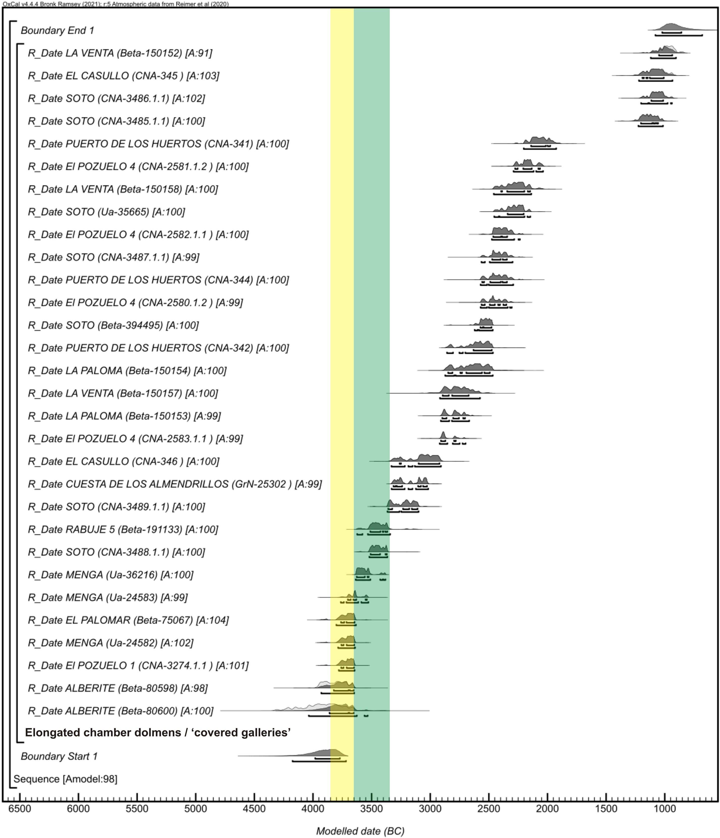
The distribution of the radiocarbon dates shows that the elongated monuments must have been developed in the last part of the Late Neolithic, with their construction continuing in the Final Neolithic and their re/construction and funerary reuse during the Copper Age.
The comparative study of the Los Llanetes cluster with other dated dolmens in western Andalusia is able to propose a diachronic sequence in four stages:
-
Stage 1. Emergence and construction of the first elongated monuments, in about the 3800–3600 cal BC, as indicated by the dates at El Pozuelo 1, Alberite, Menga, El Palomar and Soto. The large monuments were built with recycled supports (standing-stones and steles) from previous open structures located at the site, as demonstrated in the sequences of Soto (Bueno et al. Reference Bueno Ramírez, Linares-Catela, Balbín Berhmann and Barroso Bermejo2018) and Casas de Don Pedro (Gavilán Ceballos and Mas Cornellá Reference Gavilán Ceballos and Mas Cornellá2021).
-
Stage 2. Consolidation in the second third of the fourth millennium cal BC and territorial spread of the necropolises with elongated chambers or/and covered galleries in the last third of the fourth millennium cal BC, as suggested by the dates for monuments in the sierras of Huelva and Málaga.
-
Stage 3. Construction, reconstruction, maintenance of funerary activity and reuse of dolmens during the third millennium cal BC. Twelve dates in the Copper Age are available for dolmens in the areas of eastern Andévalo and Tierra Llana in Huelva.
-
Stage 4. Dismantling, closure and/or reuse during the Bronze Age.
The date of Phase 2 at El Pozuelo 1 establishes the chronology of this architectural model between 3800 and 3600 cal BC, as the Bayesian model marks the chronological boundaries for the construction and funerary activity ca. 3850–3540 (95%) or 3790–3620 cal BC (68%). In the Los Llanetes cluster it has been verified that these monuments were developed by rebuilding previous dolmens, by means of two main actions: (a) elongating the chamber by adding orthostats to the walls and ceiling (Dolmens 1 and 2) or building antechambers with transversal slabs (Dolmens 3 and 4); and (b) the concentric enlargement of the mounds. The monuments are characterized by elongated structures with two interior sectors, by which the chamber is differentiated from one that precedes it, either an antechamber or a space with a different size and shape and a marked bend in the left wall. The length varies from 5.5 to 7.75 m. The circular or oval mounds range from 11 to 15 m in their maximum diameter.
Later, probably in the second third of the fourth millennium cal BC, another building project was carried out in El Pozuelo 4 (Phase 3). This reproduced the spatial enlargement and segmentation. The monument was converted into a covered gallery divided into three areas of varying width and height: open corridor, antechamber, and chamber.
The architectural patterns and building sequence at Los Llanetes are equally seen in numerous elongated monuments in southern Iberia, from the largest constructions (Menga, Alberite, Soto and La Casilla) to most of the dolmens in the western Sierra Morena (Casas de Don Pedro, La Lancha, Los Gabrieles 4 and 6, La Cantina, among others), Guadalquivir valley (El Palomar), mountains of Málaga (Cruz Blanca, Tajillo del Moro, Encinas Borrachas 1, Chaperas 1), areas in Cádiz (El Juncal, Las Rosas) and even the Algarve (Santa Rita) and Alentejo (Anta das Cabeças, Rabuje 5).
Published radiocarbon dates indicate that the emergence of dolmens with elongated chambers and covered galleries in this geographic area would have occurred ca. 3800–3700 cal BC (García Sanjuán et al. Reference García Sanjuán, Weathley, Costa Caramé and García Sanjuán2011). The oldest dates come from the large monuments (Alberite, Menga and Soto) and other dolmens, such as El Palomar, dated ca. 3910–3630 cal BC (Cabrero et al. Reference Cabrero García, Ruiz Moreno, Blas Cuadrado and Sabaté1997).
The date for Phase 2 at El Pozuelo 1 is coetaneous with the dates of Alberite, for which two dates come from different contexts: (a) a combustion level associated with the ochre floor in the last part of the chamber, ca. 4340–3970 cal BC; and (b) a hearth in the outer area associated with the dolmen construction level, ca. 4230–3650 cal BC (Ramos Muñoz and Giles Pacheco Reference Ramos Muñoz and Giles Pacheco1996). These chronometric results propose, at first sight, an early chronology for the origin of the elongated monuments, as they are the oldest dates in Andalusia. However, it is likely that Alberite is a more complex monument than previously thought and encompasses a building sequence like that of El Pozuelo 4. The structural and stratigraphic evidence of the superimposition of foundation trenches and additions to the lines of orthostats suggests that the morphology of the dolmen is the result of the concatenation of three projects, which correspond to the three spaces: (a) Phase 1, trapezoidal chamber 11 m long, with a transversal slab in the right wall and three steles-jambs next to the south wall; (b) Phase 2, addition of a longitudinal covered passage, 7m long; and (c) Phase 3, access and atrium between the mounds. It is therefore feasible that the two dates are correlated with the first of these architectural phases, and they are similar to the dates obtained at El Pozuelo 1 and 4.
The dates for other large elongated monuments, such as Menga and Soto, equally indicate a complex diachronic process and attest the consolidation of the architectural model in the southwest of Andalusia in the second third of the fourth millennium cal BC. Two dates in Menga come from Structure E-9 in the atrium, belonging to an earlier occupation phase very close to the construction of the dolmen: the results are 3800–3640 cal BC and 3770–3520 cal BC. Another date from the level and the base of the construction of the mound ratifies that the monument was built ca. 3640–3380 cal BC (García Sanjuán and Lozano Rodríguez Reference García Sanjuán, Lozano Rodríguez and Laporte2016). We consequently believe that this large monument would have been built in at least three phases, in accordance with the clearly differentiated parts: elongated chamber with central pillars, antechamber and open atrium.
Two dates for areas in Soto dolmen attest a sequence coherent with the process identified at El Pozuelo in the second half of the fourth millennium cal BC. The first, from a posthole in the outer frontal area shows that structures existed in the surroundings coetaneously with the dolmen, ca. 3520–3360 cal BC. The second date, from a level of an intentional fill of a hypogeum, marks a terminus post quem for the work that transformed the access and monumentalized the outer area, by the creation of an ambulatory, ca. 3370–3100 cal BC (Linares-Catela and Mora Molina Reference Bueno Ramírez, Linares-Catela, Balbín Berhmann and Barroso Bermejo2018).
The radiocarbon date for the dolmen of Rabuje 5, ca. 3630–3340 cal BC (Boaventura Reference Boaventura2009), is related to the addition of the open corridor and the enlargement of the mound, forming an elbowed elongated chamber 5 m long inside a structure 11 m in diameter (Mataloto et al. Reference Mataloto, Andrade and Pereira2017). This site therefore confirms the presence of elongated chambers in Alentejo from the mid-fourth millennium cal BC, probably coetaneous with analogous processes in other dolmens in southern Portugal. The determinations of the Santa Rita dolmen attests to the presence of elongated chambers in the Algarve from ca. 3200 cal BC (Emslie et al. Reference Emslie, Silva, Valera, Vijande Vila, Melo, Curate, Fidalgo, Inácio, Molina Moreno, Cambra-Moo, González Martín, Barroso-Bermejo, Montero Artús and García Sanjuán2022).
The dates at other sites confirm the expansion and abundance of dolmens with elongated chambers of small covered galleries in necropolises in different areas during the last third of the fourth millennium cal BC; for examples the dolmen of the Cuesta de Los Almendrillos in Sierra de las Nieves in Málaga (Fernández Ruiz and Márquez Romero Reference Fernández Ruiz and Márquez Romero2001) and El Casullo in eastern Andévalo in Huelva (Linares-Catela and García Sanjuán Reference Linares-Catela and García Sanjuán2010).
Twelve Copper Age dates are available for dolmens in the areas of eastern Andévalo and Tierra Llana in Huelva, confirming continuity in the building and rebuilding of the monuments and intense funerary activity in the third millennium cal BC. These dolmens are clustered in necropolises with a predominance of longitudinal elongated chambers about 7.5–10 m long, oriented towards the east, inside circular or oval mounds about 12–20 m in diameter. These radiocarbon dates come from the dolmens of La Ploma and La Venta in the necropolis of El Villar (Nocete et al. Reference Nocete, Lizcano, Nieto, Sáez, Linares, Orihuela and Rodríguez2004) and Puerto de los Huertos in the El Gallego-Hornueco group (Linares-Catela and García Sanjuán Reference Linares-Catela and García Sanjuán2010). They confirm the funerary use and reform of the façades, including the addition of ritual structures in the outer areas at the front, in the same way as in the older large covered galleries, as documented in Phases 5 (2920–2700 cal BC) and 6 (2580–2230 cal BC) in El Pozuelo 4. In Soto Dolmen, the dates are related to funerary activity (2630–2460 cal BC), votive contexts (2570–2290 cal BC) and areas with metallurgical activity (2460–2140 cal BC) outside the dolmen (Linares-Catela and Mora Molina Reference Bueno Ramírez, Linares-Catela, Balbín Berhmann and Barroso Bermejo2018; Nocete et al. Reference Nocete, Sáez, Rodríguez Bayona, Peramo, Inacio and Abril2011).
The other dates for elongated monuments come from various stratigraphic contexts and stages of the Bronze Age and establish the time of social practices such as the dismantling, closure and reuse of the sites. Two of them are correlated with different re-appropriation actions in the Early Bronze Age, in the last two centuries of the third millennium and the first century of the second millennium cal BC. The date for El Pozuelo 4 (2290–2030 cal BC) reflects the process of the dismantling of the dolmens to build the surrounding terraced enclosure (Phase 7). The date of the ditch that destroyed the dolmen at Puerto de los Huertos (2210–1920 cal BC) marks an event for the intentional closure of the monument by dismantling and concealing it (Linares-Catela and García Sanjuán Reference Linares-Catela and García Sanjuán2010). Four dates correspond to the reuse of the dolmens of Soto, El Casullo and La Venta in the Final Bronze Age, between 1200 and 900 cal BC. In Soto Dolmen, two dates for a structure in the outer access area at the front situate ritual fire practices ca. 1230–930 cal BC (Linares-Catela and Mora Molina Reference Bueno Ramírez, Linares-Catela, Balbín Berhmann and Barroso Bermejo2018), which is an interval coherent with the weapons engraved on stones in the passage during this time and which is similar to the intervals for the deposit in the Ria of Huelva, ca. 1050–950 cal BC (Ruiz Gálvez Reference Ruiz Gálvez and Ruiz Gálvez1995). Other dates from the dolmens of El Casullo (Linares-Catela and García Sanjuán Reference Linares-Catela and García Sanjuán2010) and La Venta (Nocete et al. Reference Nocete, Lizcano, Nieto, Sáez, Linares, Orihuela and Rodríguez2004) equally support the reuse of the inner areas in that time.
Dolmens with Multiple Chambers
The dolmens with multiple chambers are outstanding monuments in the context of the Iberian Peninsula. They are only found in the western Sierra Morena, mostly in eastern Andévalo and its periphery. The sites of El Pozuelo, Las Huecas, Los Gabrieles, El Labradillo and Lapa del Moro are the most important (Linares-Catela Reference Linares-Catela2017). They display great structural variety and spatial composition, including dolmens with double parallel chambers or perpendicular chambers, elbowed structures and dolmens with four asymmetrical chambers or five parallel chambers. These complex architectures are inside circular mounds 20–25 m in diameter.
Five sites have been dated by a total of 25 radiocarbon determinations, allowing an analysis of their chronological distribution (Figures 13f and 18). The sequence at Los Llanetes is crucial to establish the temporalities of their origin, transformation and reuse, through 21 dates. Modeling the five dates connected with construction and spatial restructuring provides a range of ca. 3710–3170 BC (95%) or 3660–3260 (68%), with greater intensity in the second third of the fourth millennium. Several phases associated with different uses and practices followed that time:
-
The appearance of the dolmens with multiple chambers ca. 3650–3600 cal BC, as suggested by the two oldest dates of Phase 3 at El Pozuelo 1.
-
Construction of the first structures in the outer area in the last third of the fourth millennium, ca. 3310–3030 cal BC, at El Pozuelo 1.
-
Proliferation of structures in the atria in the first half on of the third millennium, ca. 3060–2510 cal BC. In the case of El Pozuelo 1, the ritual activity may have been concentrated in a time of less than a century.
-
Continuity of the funerary activity in the second half of the third millennium, ca. 2650–2140 cal BC, probably concentrated between 2500 and 2200 cal BC. This has also been documented in Chamber 2 at Los Gabrieles 4, with two dates situating activity ca. 2570–2200 cal BC (Linares Catela Reference Linares-Catela2006).
-
Partial dismantling of the monuments and reuse of the dolmens in connection with the emergence of terraced enclosures in the last quarter of the third millennium, ca. 2290–1880 cal BC. The reuse of the inner spaces was usual in the Early Bronze Age, as confirmed by the dates at Los Llanetes and the date for the upper level in Chamber 2 in Los Gabrieles 4, ca. 2280–1940 cal BC (Linares Catela Reference Linares-Catela2006).
-
Reuse of the monuments in events with a short duration in the Middle and Late Bronze Age.
Bayesian modeling of the multiple chamber dolmens in Iberian southwest. Green stripe: emergence and consolidation chronology (OxCal v.4.4 Bronk Ramsey [Reference Bronk Ramsey2021]; r:5 IntCal20 atmospheric data from Reimer et al. [Reference Reimer, Austin, Bard, Bayliss, Blackwell, Bronk Ramsey, Butzin, Cheng, Edwards, Friedrich, Grootes, Guilderson, Hajdas, Heaton, Hogg, Hughen, Kromer, Manning, Muscheler, Palmer, Pearson, Van der Plicht, Reimer, Richards, Scott, Southon, Turney, Wacker, Adolphi, Büntgen, Capano, Fahrni, Fogtmann-Schulz, Friedrich, Köhler, Kudsk, Miyake, Olsen, Reinig, Sakamoto, Sookdeo and Talamo2020]).

Terraced Enclosures and Megalithic Cists
The documentation of terraced enclosures with circular platforms at El Pozuelo introduces several aspects referring to the significance, complexity and temporality of megalithism in the Early Bronze Age. They were built and used ca. 2290–1800 cal BC and abandoned in the interval of ca. 1880–1640 cal BC. The initial radiocarbon dates for these monuments coincide with the 4.2 kyr event, from 2200 cal BC. This event involved a change in the environmental conditions, with increasing aridity and cultural collapse of southern Iberian societies (Blanco-González et al. Reference Blanco-González, Lillios, López-Sáez and Drake2018). In connection with this process, some authors have described a progressive decline in architectural monumentality and the end of the megalithic phenomenon, with a reduction in the size of the structures and a decrease in the use of the megalithic tombs (García Sanjuán et al. Reference García Sanjuán, Weathley, Costa Caramé and García Sanjuán2011). Nonetheless, the existence of terraced enclosures attests the emergence of a new model of monument and the permanence of megalithic architecture in the Early Bronze Age. This form of monument was based on the re-appropriation of the ancient structures, the integration of the dolmens as central elements, and technical continuity in building with orthostats. Similar patterns have been identified at other sites in southwest Iberia, as in the necropolis of La Orden-Seminario, where funerary monuments developed ca. 2300–1900 cal BC, characterized by the reuse of the space containing collective Chalcolithic burials for the introduction of individual tombs. These burials involved the perpetuation of the building models in the megalithic tradition together with inegalitarian funerary patterns and rituals (Linares-Catela Reference Linares-Catela2020).
The persistence of certain building models and funerary patterns in the megalithic cists might equally be understood within this line of continuity of the phenomenon. The available dates show that they existed in the transition from the third to the second millennium cal BC (Figures 13g and 19), as in the cases of Tombs A and B at Cortijo de El Tardón (Fernández Ruiz et al. Reference Fernández Ruiz, Marqués Merelo, Ferrer Palma, Baldomero Navarro and Balbín Berhmann1997) and Cist 20 at La Traviesa (García Sanjuán Reference García Sanjuán1998).
Bayesian modeling of the megalithic cists in Iberian southwest. Orange stripe: emergence chronology (OxCal v.4.4 Bronk Ramsey [Reference Bronk Ramsey2021]; r:5 IntCal20 atmospheric data from Reimer et al. [Reference Reimer, Austin, Bard, Bayliss, Blackwell, Bronk Ramsey, Butzin, Cheng, Edwards, Friedrich, Grootes, Guilderson, Hajdas, Heaton, Hogg, Hughen, Kromer, Manning, Muscheler, Palmer, Pearson, Van der Plicht, Reimer, Richards, Scott, Southon, Turney, Wacker, Adolphi, Büntgen, Capano, Fahrni, Fogtmann-Schulz, Friedrich, Köhler, Kudsk, Miyake, Olsen, Reinig, Sakamoto, Sookdeo and Talamo2020]).
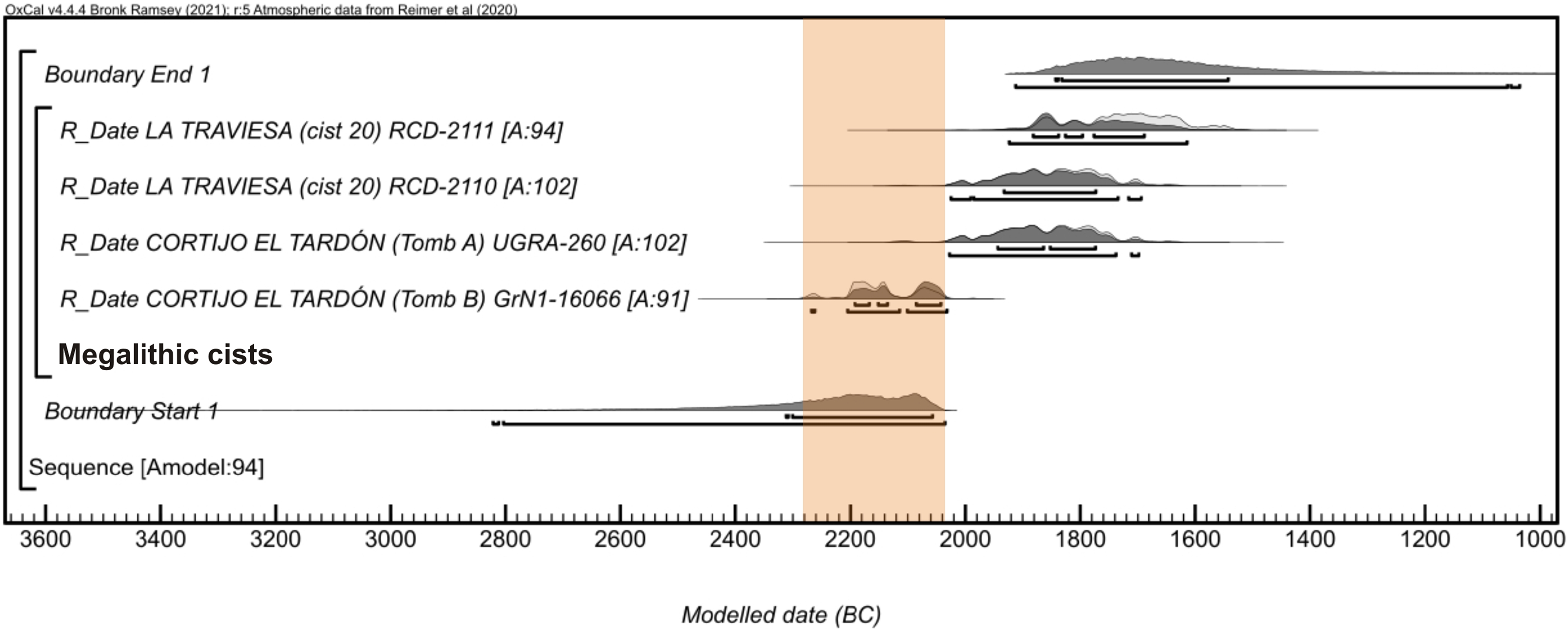
Conclusions
The chronological study of the megalithic complex at El Pozuelo has been based on the detailed knowledge of the complex architectural sequences, the stratigraphic contextualisation of the samples and the Bayesian modeling of the radiocarbon results. This methodology allows us to assign a chronology to specific events (building, remodeling, activities, and uses) and establish the temporal boundaries of the different phases at the site.
The radiocarbon dates at Los Llanetes cluster reveal the oldest age of dolmens in the area and the long duration of the megalithic site during Later Prehistory, from the early fourth to the early second millennia cal BC. The chronometric results reflect aspects in the rhythm, activity and intensity of use analogous with other architectural models and regions, and thus add new data supporting the determination of the chronological sequence of megalithism in the southwest of the Iberian Peninsula.
The greatest intensity in the construction and use of the dolmens at El Pozuelo occurred in the fourth millennium cal BC, when several models of dolmens followed one another, apparently without hiatuses. The first dolmens with access from outside were built in in the form of simple chambers from the beginning of the fourth millennium, ca. 3950 cal BC. Their chronology is similar to that of the some protomegalithic tombs (ca. 4300–3800 cal BC) and the first elongated dolmens in western Andalusia and to the passage graves in the Tagus basin.
The expansion and diversity of monuments in southwest Iberia coincide with the generalized change in the realm of death ca. 3800 cal BC, as consequence of the emergence and consolidation of collective burials in the megalithic tombs. Around 3800–3600 cal BC, various regions witnessed the asynchronic proliferation of dolmens in different forms and building techniques. The architectural polymorphism of the monuments might be connected with the existence of building styles, technical traditions and cultural identities in the different megalithic territories.
The development of elongated monuments in western Andalusia, from ca. 3750 cal BC onwards, can be understood in this context. The covered galleries consolidated in the second third of the fourth millennium cal BC and continued to be built throughout the second half of the millennium. Short and long passage dolmens appeared in the Lisbon and Alentejo regions from 3700 cal BC, and co-existed with small simple-chamber antas until 3000 cal BC. Dolmens with multiple chambers developed ca. 3650 cal BC, as shown by the dates at El Pozuelo and that form of building activity lasted until the end of the millennium.
Intense funerary and ritual activity has been documented in all the architectural models during the third millennium cal BC. This is shown by the monumentalization and addition of structures in the outer areas and the use/reuse of the inner spaces. In the Huelva area, the dates even show that the dolmens with elongated chambers and small covered galleries continued to be built in the first half of the third millennium cal BC.
In the last quarter of the third millennium cal BC, a new form of monument developed: the terraced enclosures with circular platforms. In this way, El Pozuelo demonstrates the continuity of megalithism in the Early Bronze Age. Evidence of later reuses in the Middle and Late Bronze Age is frequent in most of the dolmens in the Iberian southwest.
FUNDING AND ACKNOWLEDGMENTS
This study has been carried out within the framework of the R+D+i Project “MEGA-LITHOS. Geo-archaeological study methods for the investigation of the Huelva megalithisms” (UHU-1263153) at the University of Huelva, funded by the Operative Programme ERDF 2014-2020 and the Department of Economy and Knowledge in the Government of Andalusia. The radiocarbon dates were commissioned at the CNA by the Culture Department in the Government of Andalusia within the Exceptional Archaeological Activity under our direction. The funding of the open access charge has been assumed by the University of Huelva, thanks to the agreement established with Cambridge University Press. I am grateful to Coronada Mora Molina for her invaluable participation in the excavation and research of the Los Llanetes cluster. Juan Carlos Vera-Rodríguez and Luc Laporte, supervisors of my doctoral thesis, for their guidance and observations for the investigation. Mónica Ruiz Alonso has contributed to the anthracological study of the charcoal samples. Thanks to the reviewers for their comments and suggestions, which have improved several aspects of the work.
SUPPLEMENTARY MATERIAL
To view supplementary material for this article, please visit https://doi.org/10.1017/RDC.2022.48.


 Open access