

Introduction
Deep Antarctic ice cores have revolutionized our understanding of climate conditions and drivers for the past eight glacial cycles (Reference JouzelJouzel and others, 2007a). However, dating of ice cores depends on the determination of gas–ice age differences and the interpretation of temperature changes from isotopes, which are sensitive to net snow accumulation changes, bubble close-off differences and firn-column properties, all of which change significantly between glacial and interglacial time periods (Reference Masson-DelmotteMasson-Delmotte and others, 2006; Reference ParreninParrenin and others, 2013).
Snow metamorphism is a primary driver of the transition from snow to ice and can be accompanied by altered isotopic compositions and chemical species concentration. Highly metamorphosed snow results in major structural changes, and is poorly understood but has been identified in few places in Antarctica. Reference Albert, Shuman, Courville, Bauer, Fahnestock and ScambosAlbert and others (2004) and Reference Courville, Albert, Fahnestock, Cathles and ShumanCourville and others (2007) described the physical properties of highly metamorphosed snow in the megadunes of East Antarctica, but properties of snow and firn patches within blue-ice fields, such as the Allan Hills, have not been discussed so far.
Low-accumulation regions can experience significant vapour-pressure gradient driven metamorphism, caused by either wind-driven ventilation or long-term alternating temperature-gradients (Reference Pinzer and SchneebeliPinzer and Schneebeli, 2009). Forced ventilation can also cause vapour exchange between the snow and the atmosphere (Reference Moser and StichlerMoser and Stichler, 1974; Reference Sommerfeld, Friedman, Nilles, Jones and Orville-ThomasSommerfeld and others, 1987; Reference ColbeckColbeck, 1989; Reference Town, Warren, Walden and WaddingtonTown and others, 2008; Reference Steen-LarsenSteen-Larsen and others, 2014) and further affect the snow structure and isotopic composition. In addition to the large amount of metamorphism that affects the snow post-depositionally, the snow in the Allan Hills is unique because it is deposited under strong winds and therefore with a high initial density, resulting in a high-density snowpack.
Stable isotope composition of precipitation is closely linked to local air temperature (Reference DansgaardDansgaard, 1964), and changes in δD and δ18O can be interpreted as local temperature variations, changes in moisture-source region, the seasonality of the snowfall, changes in sea-surface temperature, atmospheric circulation, cloud temperature and the height of the inversion layer in the interior of the ice sheets (Reference Cuffey, Clow, Alley, Stuiver, Waddington and SaltusCuffey and others, 1995; Reference Kavanaugh and CuffeyKavanaugh and Cuffey, 2003) or post-depositional modifications. Numerous studies discuss the relationship between regional temperature and isotope concentrations in ice cores to obtain past temperature reconstructions (e.g. Reference DansgaardDansgaard, 1964; Reference Lorius and MerlivatLorius and Merlivat, 1977; Reference Dahe, Petit, Jouzel and StievenardDahe and others, 1994; Reference Cuffey, Clow, Alley, Stuiver, Waddington and SaltusCuffey and others, 1995; Reference SteigSteig and others, 1998; EPICA Community Members, 2004; Reference Masson-DelmotteMasson-Delmotte and others, 2008). In general, the δ18O and δD ratio is less negative with increasing accumulation rate and increasing temperature (Reference DansgaardDansgaard, 1964), if post-depositional processes are neglected. Post-depositional changes, however, can significantly alter the isotopic signal and further complicate the interpretation of ice-core records (Reference Moser and StichlerMoser and Stichler, 1974; Reference Sommerfeld, Friedman, Nilles, Jones and Orville-ThomasSommerfeld and others, 1987, Reference Sommerfeld, Judy, Friedman, Taylor, O’Neill and Kaplan1991; Reference Friedman, Benson, Gleason, Taylor, O’Neill and KaplanFriedman and others, 1991; Reference Cunningham and WaddingtonCunningham and Waddington, 1993; Reference Waddington, Cunningham, Harder, Wolff and BalesWaddington and others, 1996; Reference McConnell, Bales, Stewart, Thompson, Albert and RamosMcConnell and others, 1998; Reference StichlerStichler and others, 2001; Reference Albert, Shuman, Courville, Bauer, Fahnestock and ScambosAlbert and others, 2004; Reference Neumann and WaddingtonNeumann and Waddington, 2004; Reference Town, Warren, Walden and WaddingtonTown and others, 2008; Reference Ekaykin, Hondoh, Lipenkov and MayamotoEkaykin and others, 2009; Reference Sokratov and GolubevSokratov and Golubev, 2009; Reference Steen-LarsenSteen-Larsen and others, 2014). Isotopic ratios can be altered by diffusion processes (through kinetic fractionation) and by phase changes (through equilibrium fractionation) in the snowpack (Reference McConnell, Bales, Stewart, Thompson, Albert and RamosMcConnell and others, 1998; Reference JouzelJouzel and others, 2007b). First, the amplitude of the isotopic signal in snow, and the seasonal signal in particular, is smoothed with time through molecular diffusion processes, which can homogenize the isotopic record over small time- and length-scale without alteration of the mean isotope content (Reference LangwayLangway, 1967; Reference Whillans and GrootesWhillians and Grootes, 1985; Reference Cuffey and SteigCuffey and Steig, 1998; Reference Johnsen, Clausen, Cuffey, Hoffmann, Schwander, Creyts and HondohJohnsen and others, 2000). Reference Johnsen, Clausen, Cuffey, Hoffmann, Schwander, Creyts and HondohJohnsen and others (2000) identified diffusion lengths for Greenland to be 7–10 cm, which would only affect the seasonal signal. For lower accumulation rates, however, the diffusion length of 10 cm can influence decades of accumulation and possibly diminish not only the seasonal but also a longer-lasting climatic signal. Second, the isotopic signal in snow can be altered due to water-vapour exchange between the atmosphere and the near-surface snowpack. Numerous, mostly theoretical, studies have addressed the equilibrium fractionation and the resulting relationship between the sign or magnitude of ice sublimation or deposition and trends in isotopic changes in surface snow (Reference Epstein, Sharp and GowEpstein and others, 1965; Reference JouzelJouzel and others, 1997; Reference Ekaykin, Lipenkov, Barkov, Petit and Masson-DelmotteEkaykin and others, 2002; Reference Waddington, Steig and NeumannWaddington and others, 2002; Reference NeumannNeumann, 2003; Reference Neumann and WaddingtonNeumann and Waddington, 2004; Reference Town, Warren, Walden and WaddingtonTown and others, 2008). There has been a general consensus that when water vapour condenses, the heavy isotopologues become enriched in the liquid–solid phase, while the vapour becomes depleted in the heavy isotopologues. Reference Steen-LarsenSteen-Larsen and others (2014), however, have been unable to identify any systematic relationship between the sign or magnitude of sublimation or deposition and trends in isotopic changes in measurements of surface snow and conclude that post-depositional changes are caused by changes in the near-surface atmospheric water-vapour isotopic composition, which is driven by ‘synoptic variations and changes in air mass trajectories’, large-scale winds and moisture advection. The uptake of the atmospheric water vapour is further controlled by continuous recrystallization in the snow (Reference Pinzer, Schneebeli and KaempferPinzer and others, 2012; Steen-Reference Steen-LarsenLarsen and others, 2014) and replacement of the pore-space water vapour in snow with atmospheric water vapour. The continuous recrystallization and large mass turnover, as observed by Reference Pinzer, Schneebeli and KaempferPinzer and others (2012) and modelled by Reference Steen-LarsenSteen-Larsen and others (2014), leads to a rapid imprint of changes in near-surface water-vapour isotopic composition in surface snow (Reference Steen-LarsenSteen-Larsen and others, 2014).
The deuterium excess d (d = δD − 8 × δ18O; Reference DansgaardDansgaard, 1964) is often interpreted as an indicator of the temperature and relative humidity at the moisture source (e.g. Reference DansgaardDansgaard, 1964; Reference Merlivat and JouzelMerlivat and Jouzel, 1979; Reference Delmotte, Masson and JouzelDelmotte and others, 2000) and reflects the ‘kinetic fractionation occurring during non-equilibrium fractionation processes such as evaporation above the ocean’ (Reference VimeuxVimeux and others, 2001), sublimation at very low temperatures or condensation (Reference Cappa, Hendricks, DePaolo and CoheCappa and others, 2003), including the recrystallization in the snowpack (Reference Steen-LarsenSteen-Larsen and others, 2014). The kinetic effect is a function of the relative humidity of air and depends on the size and the geometry of crystals (Reference Luz, Barkan, Yam and ShemeshLuz and others, 2009). It becomes stronger with decreasing temperature and increasing wind speed, conditions generally occurring during cold periods or in dry and windy areas such as the Allan Hills. Kinetic fractionation is associated with water-vapour diffusion, owing to different diffusivities for the isotopically different water molecules in air and resulting in stronger fractionation between hydrogen (1H) and deuterium (2H) than between 16O and 18O because of smaller relative mass differences of the oxygen isotopes (Reference MerlivatMerlivat, 1978; Reference Cappa, Hendricks, DePaolo and CoheCappa and others, 2003; Reference Luz, Barkan, Yam and ShemeshLuz and others, 2009). Negative d values are therefore uncommon but have been reported from coastal locations and the Dry Valleys in Antarctica (Reference Masson-DelmotteMasson-Delmotte and others, 2008; Reference Bertler, Mayewski and CarterBertler and others, 2011). Negative d values occur in particular when air masses with enriched isotope values are precipitated at extremely low temperatures (Reference Kavanaugh and CuffeyKavanaugh and Cuffey, 2003) and can also be associated with exceptionally long and continuous post-depositional evaporation/sublimation processes, such as may occur in the Allan Hills. Reference Bertler, Mayewski and CarterBertler and others (2011) found a sharp transition from positive to negative average d values in the Dry Valleys at the onset of the Little Ice Age (LIA), around AD 1400, which responded to lower temperatures and reduced relative humidity, perhaps resulting from a larger, more active Ross Sea polynya due to stronger katabatic winds during this period. Reference Masson-DelmotteMasson-Delmotte and others (2008) found that all sites with negative d are below 2400 m a.s.l. and thus might be caused by wind ablation effects, which reduce accumulation and therefore ‘increase the residence time of snow crystals in the surface zone characterised by strong temperature gradients’. The strong temperature gradients and forced ventilation induce pressure gradients and moisture movement within the snowpack as well as water-vapour exchange between the firn and the atmosphere, leading to isotopic fractionation in the firn.
The water-vapour movement can be intensified by pressure differences caused by wind-driven ventilation in the near-surface (Reference Waddington, Cunningham, Harder, Wolff and BalesWaddington and others, 1996; Reference AlbertAlbert, 2002; Reference NeumannNeumann, 2003; Reference Town, Warren, Walden and WaddingtonTown and others, 2008) and by macroscopic temperature gradients. Post-depositional isotopic modifications in the snowpack and snow metamorphism are dependent on the duration of snow exposure to the atmosphere (Reference Moser and StichlerMoser and Stichler, 1974), which, for low-accumulation areas such as the Allan Hills, can be hundreds of years. The duration and depth of the isotopic modifications in the snowpack also depend, to a lesser degree, on recrystallization activity due to snow compaction (likely to be low in the Allan Hills) and molecular diffusion of water vapour (Reference Johnsen, Clausen, Cuffey, Hoffmann, Schwander, Creyts and HondohJohnsen and others, 2000). Both of these processes can continue for hundreds of years and affect the entire firn column (Reference Whillans and GrootesWhillians and Grootes, 1985; Reference Johnsen, Clausen, Cuffey, Hoffmann, Schwander, Creyts and HondohJohnsen and others, 2000).
The aim of this paper is to improve our understanding of the physical properties and isotopic composition of firn in low-accumulation regions. We analyse a 5m firn core collected next to a blue-ice field in the Allan Hills, Antarctica. First, we discuss physical properties; in particular density, specific surface area (SSA) and average thickness of the ice structure and pore space as determined by microcomputed tomography (micro-CT). To date, there are no existing SSA measurements for snow from very low-accumulation regions. Second, we investigate the stable isotope ratios, δ18O and δD, as well as deuterium excess, d (d = δD − 8 × δ18O; Reference DansgaardDansgaard, 1964). Third, we discuss the 210Pb activity in order to estimate the age of the firn.
Our hypothesis is that the unique snow structure and the stable isotope composition in the Allan Hills snow is caused by: (1) microscopic pressure gradients in the firn that are the result of either forced ventilation over rough surfaces in the presence of wind or alternating seasonal temperature-gradients that this snow has been exposed to, because of low accumulation rates that cause the snow to stay near the surface for a long time; (2) high-impact wind-driven snow deposition, which results in a high initial density; and (3) increased vapour transport due to forced wind ventilation and air exchange between the atmosphere and the snowpack, which is active during the long residence time of snow near the surface. Furthermore, we estimate that the measured firn core is older than any snow previously encountered at the given depth (∼660 years at 5 m depth, and maybe older) and is a possible analogue for cold and windy glacial conditions, with accumulation lower than that of today.
Methods
Antarctic blue-ice areas occupy about 1% of the Antarctic ice-sheet surface. They are usually located near rock outcrops and are characterized by high winds and net ablation (Reference BintanjaBintanja, 1999). Blue-ice areas have been studied because of their importance in the search for meteorites (Reference Whillans and CassidyWhillans and Cassidy, 1983; Reference Cassidy, Harvey, Schutt, Delisle and YanaiCassidy and others, 1992; Reference HarveyHarvey and others, 1998), for their peculiar meteorological conditions and negative surface mass balance (Reference Bintanja and Van den BroekeBintanja and van den Broeke, 1995; Reference BintanjaBintanja, 1999; Reference Bintanja and ReijmerBintanja and Reijmer, 2001), because of their potential for palaeoclimate reconstructions using ice cores (Reference SpauldingSpaulding and others, 2012, Reference Spaulding2013) and as an analogue for Snowball Earth scenarios because of their unique ice surface (Reference Dadic, Mullen, Schneebeli, Brandt and WarrenDadic and others, 2013).
Here we report on a 5 m firn core collected from a snowpatch within a blue-ice field in the Allan Hills (−76.67°, 159.23°; Fig. 1) in January 2011. The location of the core was the Allan Hills Main Ice Field, which is dominated by sublimating blue ice. Local topographical depressions facilitate the formation of small accumulating snowpatches within the ice field. The low ice velocities (∼0.16 m a−1 for the closest measured point on blue ice, P10, in Reference SpauldingSpaulding and others (2012)) cause that accumulated snow to be preserved in these topographic depressions for many hundreds of years, before it reaches sublimating areas.
Allan Hills, Antarctica, from Landsat Mosaic of Antarctica (Reference BindschadlerBindschadler and others, 2008) with location of the firn core.

The core was transported from the field camp (stored in a snowdrift at temperatures of −20°C to −30°C) to McMurdo station’s Crary Laboratory (at −30°C) in plastic ice-core sleeves, was cut at McMurdo station into ∼30 cm pieces and was shipped (at −60°C during transport) to the WSL Snow and Avalanche Institute (SLF) in Davos, Switzerland, where it was stored at −25°C before cutting for the different analyses. We assume that no significant structural changes have taken place in the firn during storage. Core analyses include physical properties, stable water isotope ratios and 210Pb activity.
Physical properties using micro-CT
We have micro-CT scans from eight firn samples in the depth range 61–469 cm (evaluated in March 2012). We used the same instruments and procedures as described by Reference Dadic, Mullen, Schneebeli, Brandt and WarrenDadic and others (2013) to image and measure the microstructural properties of the snow and firn samples. As well as the eight samples below 61 cm, we have additional scans from three cast samples in the depth range 0–36 cm (evaluated in August–October 2011, every 1 vertical mm). The cast samples were collected from a shallow snow pit, ∼50 m from the location of the 5 m core. The samples were cast with diethyl phtalate (Reference Heggli, Frei and SchneebeliHeggli and others, 2009), preserving the snow structures during transport and storage.
Firn samples for the micro-CT were first cored to a diameter of 36 mm using a plug cutter. Imaging was performed using a micro-CT 40 (Scanco Medical) computer tomograph. The field of view was 37 mm, effective voxel size 36 μm, peak X-ray energy 55 kV, intensity 145 A and shutter time 400 ms. The 16-bit greyscale images were then filtered using a 3 × 3 × 3 Gaussian filter with a standard deviation of 1.5 voxels and segmented (Reference Dadic, Mullen, Schneebeli, Brandt and WarrenDadic and others, 2013). The segmentation threshold for distinguishing between air and firn was 120 and was selected because it was in the middle of the trough between the peaks of air and ice in the histogram. The relatively low resolution in this study (36 μm, as opposed to the usual 18 μm resolution used in recent studies) can decrease the SSA by up to 20% and the pore-and-ice structure thickness by up to 17% (Reference Schneebeli and SokratovSchneebeli and Sokratov, 2004). Since all our samples were measured using the same resolution and we are discussing relative differences with depth, the resolution effect is insignificant. The pore-and-ice structure thickness was determined by evaluating the micro-CT images with the algorithm used by Reference Hildebrand and RüegseggerHildebrand and Rüegsegger (1997). If the pore-and-ice structures were perfect isolated spheres, each modelled sphere would represent exactly one bubble/ice sphere. Because the pore-and-ice structures in our samples were not spheres, the size rather represents the average curvature of partial spheres. This technique is like virtual sieving; it gives the size distribution as if we had sieved the pore space or ice structures.
210Pb activity
210Pb is a naturally occurring radioactive isotope with a half-life of 22.3 years that is produced in the 238U decay chain via the intermediate isotope 222Rn. 222Rn has a half-life of 3.8 days and, because it is a gas, emanates constantly from the Earth’s crust into the atmosphere. In the atmosphere it decays over several intermediate isotopes to 210Pb, which attaches to aerosols and settles onto snow surfaces by dry or wet deposition within a few days to weeks. Owing to radioactive decay, the activity of 210Pb in firn decreases with depth and can therefore be used for dating. The period accessible for dating depends mainly on the half-life and was found to be on a century timescale (Reference Gäggeler, Von Gunten, Oeschger and SchottererGäggeler and others, 1983). This is the case for (1) constant accumulation of 210Pb in the snow and (2) if no relocation of the initial 210Pb occurred (Reference Gäggeler, Von Gunten, Oeschger and SchottererGäggeler and others, 1983).
The activity of 210Pb was measured at the Laboratory of Radiochemistry and Environmental Chemistry, Paul Scherrer Institut, indirectly from the activity of its granddaughter nuclide 210Po electrolytically deposited on Ag plates. The 210Po activity was determined by measuring its alpha decay at an energy of 5.3 MeV using an α-spectrometer (Enertec Schlumberger 7164) with Polar Ice Prediction System (PIPS) detectors. Overall, 17 samples were prepared in May 2011 and measured in August 2011. The 210Pb activity in the 5m core was measured with a resolution of ∼20–40 cm
(which was determined by the amount of snow necessary for the analysis).
Stable isotopes δ18O and δD
We measured the stable isotope composition of the 5 m snow core with a 1 cm resolution for the top 50 cm (cut in April 2011, measured in May 2011), and approximately 5 cm resolution for the rest of the core (cut in May 2011, measured in August 2011). The samples were cut in the cold laboratory at the SLF, filled into vials while still frozen, and then shipped in liquid form to the Stable Isotope Laboratory at GNS Science, Wellington, New Zealand, where they were processed.
Stable isotopic ratios (δ18O and δD) of the samples were measured with a GVI IsoPrime mass spectrometer. The analytical precision for the instrument is ±0.1‰ for δ18O, ±1.0‰ for δD, resulting in an uncertainty of ±1.3‰ on the second-order parameter, deuterium excess d.
Results
Physical properties in the top 5 m of a snowpatch with very low accumulation
The density in the top 36 cm ranges from 313 to 615 kg m−3 (Fig. 2). The density profile shows high-density snow (>500 kg m−3) in the top 8 cm, overlying a layer of lower-density snow (350–400 kg m−3) down to around 26 cm. Below 26 cm, snow density is high again (400–600 kg m−3). The density of the eight firn samples between 61 and 469 cm remains high, ranging from 515 to 614 kg m−1 (Fig. 3a). The density is lowest in the top 1 m, and there is no clear trend below 1 m. The SSA is as high as 35.0 m2 kg−1 in the top 8 cm and rapidly decreases to ∼10 m2 kg−1 at 8 cm and to 5–6 m2 kg−1 at 26 cm (Fig. 2). Below 61 cm, the specific surface area (SSA) ranges between 1.8 and 4.6 m2 kg−1, exponentially decreasing with depth (Fig. 3a). The change in SSA with depth (Fig. 3a, dashed line) is ∼−2.3 m2 kg−1 m−1 at the surface and decreases to∼−0.1 m2 kg−1 m−1 at 5 m depth. Both the density and the SSA in the top 36 cm show discrete layers. Because of the lower vertical resolution below 61 cm, we cannot determine whether the layering is persistent with depth. However, we did not find distinctive layers when we visually inspected the core.
Near-surface density and SSA (measured by micro-CT), δ18O, δD and deuterium excess d. Note that the density and SSA scales are reversed.

(a) Density vs depth (dots) and SSA vs depth (cycles). Black line is the best fit to SSA data (SSA = 4.1 + 5.230.0035depth + 1.34); dashed line is slope of the best fit and shows the change of SSA with depth. (b) Average ice-structure thickness vs depth (dots) and average pore space thickness (circles) vs depth. Solid lines are best fit to data, with slope of the best fit being the change in thickness with depth. See Methods for detailed explanation of ice structure and pore space thickness.

The ice structures throughout the measured firn column below 60 cm are rounded and, apart from the pore thickness and ice-structure thickness increase with depth (Fig. 3b), show little change in geometry (Fig. 4). Both ice-structure and pore-space thickness increase almost linearly with depth (Fig. 3b), with ice-structure thickness increasing at a rate (0.258 mm m−1) twice that of pore-structure thickness (0.126 mm m−1). The core shows a gradual change in all measured physical parameters (SSA, average ice/pore thickness) except density (Fig. 3). SSA and ice-structure thickness are inversely proportional.
Micro-CT models of sampled snow in the Allan Hills. The coloured regions are ice structures; air is blank. Colours indicate icestructure thickness and are scaled for each image individually.

Snow-age estimates using210Pb activity
Except for the top 0.3 m which shows a210Pb activity of 16 mBq kg−1, no activity above the blank value (1.13 ± 0.33 mBq kg−1) was detected in the remainder of the core (Fig. 5). Assuming a constant flux of 210Pb from the atmosphere to the snow, the 210Pb can be used to provide age information and the corresponding accumulation rates. Pb has previously been used in snow to reveal the fluctuation of the temporal variability of snow accumulation (Reference Crozaz, Picciotto and De BruickCrozaz and others, 1964; Reference Suzuki, Kamiyama, Furukawa and FujiiSuzuki and others, 2004). Since 210Pb has a half-life of 22.3 years, it can be used to date snow layers from approximately the last century. Owing to the short half-life, we expect no 210Pb activity in firn older than 100 years.
210Pb activity with depth. Values below 30 cm are within the uncertainty of the measurement and can be assumed to be blanks.

Surface activity of 210Pb at the closest site with data is 20–25 mBq kg−1 at Taylor Dome (Reference MorseMorse and others, 1999), but is closer to 30 mBq kg−1 if other data (β activity) at that site are taken into account. About 30 mBq kg−1 is also the activity that was measured at the South Pole Station (Reference Crozaz, Picciotto and De BruickCrozaz and others, 1964; Reference Sanak and LambertSanak and Lambert, 1977). The top layer (0.3 m) has an activity of 16 mBq kg−1. Because we cannot distinguish if this activity is representative of the entire 0.3 m, or if there is a high-activity surface sublayer, we will treat the data as representative for the 0.3 m layer in the following discussion. Equation 1 from Reference Crozaz, Picciotto and De BruickCrozaz and others (1964) assumes that the initial 210Pb concentration in the precipitation at a given place remains constant, and remains valid even in case of variable accumulation rates
where Ah is the measured 210Pb activity at depth h, A 0 the 210Pb activity at the surface, λ the radioactive decay constant for 210Pb (0.032±0.001 a−1) and t time (years). For the measured activity of 16 mBq kg−1 in the top 0.3 m, Eqn (1) results in an age of ∼20 years, assuming A 0 of 30 mBq kg−1.
We assumed that the measured activity is representative for the middle of that 0.3 m layer, because the ice mass needed to measure 210Pb did not allow a higher vertical resolution. We estimate an accumulation rate of 0.0075 m a−1 (0.15 m per 20 years). If we further assume 0.0075 m a−1 to be a constant accumulation rate for the remainder of the core, the age estimate for the negative peak in δD/δ18O at 2.5 m is ∼330 years and the bottom of the core is ∼660 years (AD 1350). The negative peak period between 200 and 300 cm would have an age of ∼260–400 years (AD 1610–1750). The positive peak in d from 50 to 100 cm would be ∼70–130 years ago (AD 1880–1940). Assuming an ice velocity of 0.16 m a−1 (closest measured velocity (P10) in Reference SpauldingSpaulding and others (2012), the bottom of the core was 160 m upstream 1000 years ago, and was well within the topographic depression and accumulation area in which it is located today.
δ18O, δD and d variations
The surface values (top 1 cm) of δ18O and δD are ∼−32‰ and ∼−257‰ respectively (Fig. 6a). These values are in the range of expected modelled values for the altitude 2000 m a.s.l. (Reference Jouzel, Koster, Suozzo, Russel, White and BroeckerJouzel and others, 1991; Reference Dahe, Petit, Jouzel and StievenardDahe and others, 1994; Reference Masson-DelmotteMasson-Delmotte and others, 2008) and agree with the value for Allan Hills snow (−255‰) measured by Reference SpauldingSpaulding and others (2013) in 2009/10. The isotopic ratio profiles do not show a seasonal cycle (summer maxima) (Fig. 6a). Average values for δD are ∼−270‰, with variations of ±5‰, and average values of δ18O are ∼−34‰, with variations of ±2‰. The record shows significant depletion of heavy isotopes around 2.5 m (∼−315‰ for δD (not shown), and ∼−38.5‰ for δ18O (Fig. 6a)).
Stable isotopes in the firn core. (a) δ18O isotopic ratio and porosity (1 −ρ/917) with depth. (b) Deuterium excess d and porosity with depth; blue line is deuterium excess (d L) calculated using the local meteoric waterline; inset shows density vs deuterium excess d; red stars show porosity. (c) δ18O vs δD; thick black line is the linear regression of our dataset (local meteoric waterline, LMWL), dashed line is the global meteoric waterline (GMWL) and dotted line is the Antarctic regional meteoric waterline (ARMWL) (after Reference Masson-DelmotteMasson-Delmotte and others, 2008). Diamonds are samples with d between −2 and 4, triangles are samples with d < −2 and crosses are samples with d > 4.
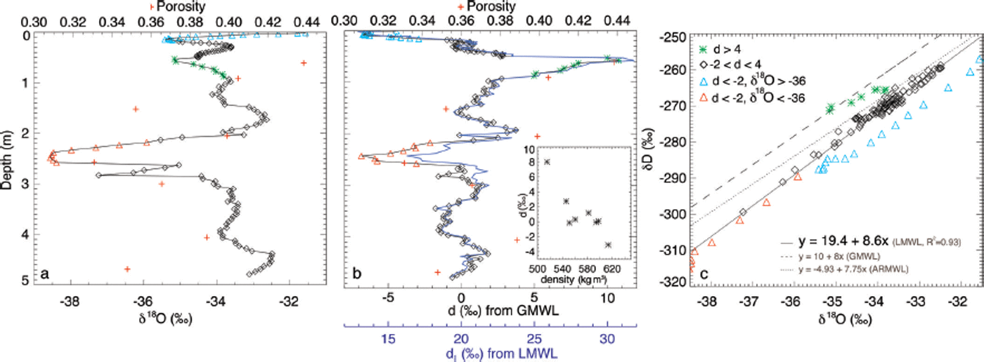
The deuterium excess d (d = δD − 8 × δ18O (Reference CraigCraig, 1961; Reference DansgaardDansgaard, 1964)) is ∼0‰ on average, similar to measurements from the Dry Valleys (Reference Masson-DelmotteMasson-Delmotte and others, 2008), but shows large variations with depth (Fig. 6b). We can distinguish three clear peaks in d: a negative peak of ∼−6‰ close to the surface, a positive peak of ∼11‰ around 50 cm depth, and another negative peak of ∼–7‰ around 2.5 m. The latter peak correlates with low values of δD and δ18O, but the other two peaks are not reflected in δD and δ18O. We also plotted d L (Fig. 6b, blue line), which we define as the deuterium excess using the local meteoric waterline (Fig. 6c, solid line). The pattern of d L is almost identical to d, but the excess is in the range 12–32‰ ( ∼20‰ higher than d), without any negative values. For the following discussion, we will use d to be consistent with existing literature. The values of d (and d L) have a negative correlation with variations in snow density (or a positive correlation with porosity (1 − ρ/917)), with higher densities (ρ ) corresponding to lower d values (Fig. 6b, inset, d = 49.1 − 0.084 × ρ).
The relationship between δ18O and δD shows that most isotopic values are aligned along the local meteoric waterline (LMWL) with a slope of 8.6 (Fig. 6c, solid line). For reference, the slope of the Global MWL is 8, and the slope of the Antarctic Regional MWL is 7.75 (Reference Masson-DelmotteMasson-Delmotte and others, 2008).
Discussion
Physical properties: a result of post-depositional processes and high-impact deposition
The snow profile close to the surface shows discrete layers (Fig. 2), which we interpret as representing either erosion events or periodically deposited snow, with no or very little deposition in between events, or a combination of both. The snow is likely to be deposited under extreme wind conditions and with high initial densities, and can therefore at times survive the strong erosion events in the area. It is, however, unclear how far the snow has been transported before final deposition. The SSA decreases exponentially with depth (Fig. 3a) and reflects the relative age of the snow (smaller SSA = older snow) better than density, which does not show a clear variation with depth. The density differences in the snow may be a result of (1) impact deposition at different wind speeds, with denser layers representing deposition events with higher winds, or (2) differences in post-depositional processes. Reference Pfeffer and MrugalaPfeffer and Mrugala (2002) showed that snow with a high initial density (>400 kg m3) does not allow for weak, low-density depth-hoar layers, such as those expected under strong temperature gradients. Their findings are in agreement with ours and support the hypothesis that snow accumulation in the Allan Hills is a result of high-impact accumulation accompanied by strong winds with a high initial density.
The snow in the Allan Hills is to some degree similar to snow found in low-accumulation areas such as Taylor Dome (Reference SteigSteig and others, 2000; Reference NeumannNeumann, 2003) or glazed sites in the megadunes (Reference Albert, Shuman, Courville, Bauer, Fahnestock and ScambosAlbert and others, 2004; Reference Courville, Albert, Fahnestock, Cathles and ShumanCourville and others, 2007), and referred to as ‘extreme snow metamorphism’. Reference Albert, Shuman, Courville, Bauer, Fahnestock and ScambosAlbert and others (2004) interpreted the thick coarse-grained layers, such as we found throughout the entire core, as periods of low accumulation, and they estimated the firn age in the top 1 m at their megadune site to be 40–140 years. Unlike the megadune measurements, our measurements show (1) no thin layers and (2) no faceted crystals. The lack of thin layers in our core implies long and sustained periods of low accumulation, in agreement with the low accumulation rate and persistent katabatic winds in the Allan Hills.
Even in cold conditions, vapour transport and metamorphism can create a high-permeability firn with large crystal sizes and large pore spaces (Fig. 3b), but not unusual densities (Reference AlbertAlbert, 2002). Sublimation and condensation within a snowpack are caused by water vapour diffusion and lead to changes in snow structure. Vapour diffusion is driven by microscopic pressure gradients resulting from (1) forced wind ventilation over rough surfaces or (2) temperature gradients, which can change direction daily or seasonally. Reference Pinzer and SchneebeliPinzer and Schneebeli (2009) showed that alternating temperature gradients do not necessarily produce faceted crystals, but result in rounded structures. They concluded that the ‘metamorphic history is not uniquely reflected in snow morphology’. Reference Brandt and WarrenBrandt and Warren (1997) showed that inversions of daily temperature gradients in Antarctica (in their case at South Pole) exist, but that the variations are only significant in the top 20–30 cm. They further showed that the difference in monthly average annual cycle is around 20 K at the surface and penetrates to a depth of ∼3.5 m (where the annual cycle is 7 K), with October–February being warmer at the surface and March–September being colder at the surface. We think that such seasonal deep-penetrating alternating temperature-gradients together with the smaller daily gradients are generating pressure gradients that cause the observed snow structures. In addition, pressure gradients caused by forced ventilation over rough surfaces, caused by high winds, may increase vapour transport within the snowpack and therefore also contribute to snow metamorphism.
Age estimates from 210Pb activity
Except for the top 0.3 m, we detected no 210Pb activity (Fig. 5), which implies either that (1) the snow below 0.3 m is older than 100 years or (2) the 210Pb in this part of Antarctica is low. The latter explanation cannot account for the 210Pb in the top layer and is therefore unlikely. Reference Suzuki, Kamiyama, Furukawa and FujiiSuzuki and others (2004) discussed the implications of erosion-distribution processes of snow on the ice sheet and concluded that regions with katabatic winds, which include nearly all of East Antarctica, are likely to have irregular (but not zero) 210Pb profiles because of post-depositional migration of snow. The snow redistribution processes cannot however explain the complete lack of activity below 30 cm.
Considering that we did not measure any 210Pb activity below 0.3 m, we can assume that the snow below 0.3 m is older than 100 years. According to our calculations, based on those of Reference Crozaz, Picciotto and De BruickCrozaz and others (1964), we estimate the accumulation rate to be 0.0075 m a−1, and the bottom of the core to be ∼660 years old. There is a possibility that we are overestimating the accumulation rate, perhaps because
(1) the measured 210Pb activity in the surface layer reflects a smaller sublayer than the 30 cm that encompasses our top sample, or (2) we assume a constant accumulation rate. Varying accumulation rates, and especially lower accumulation rates during cold intervals, might also lead to an underestimation of the firn age. Furthermore, Figure 2 shows that discrete layers in the firn are likely due to wind erosion, which could also be a reason for the complete lack of 210Pb activity below 30 cm.
δ18O, δD and d variations: too small to be seasonal, too large to be climate events
The stable isotope ratios in the near-surface samples are decoupled from the stratigraphic sequence (Fig. 2, discrete layers of physical properties (SSA, density) as opposed to the smooth isotopic profile), which indicates significant post-depositional fractionation. Isotope records at depth show little temporal variability, but with two major deviations at ∼0.5 m and ∼2.5 m (Fig. 6b), which could imply a climate signal. The periodic pattern near the surface is unlikely to be seasonal, because snow accumulation in this region is too low to preserve any seasonal temperature signals (an age estimate from 210Pb activity is an average of 20 years for the top 30 cm). The inferred temperature variations from the larger isotopic variation at ∼2.5 m would be too small (8°C applying the Taylor Dome slope function; Reference SteigSteig and others, 1998), while seasonal variations in Antarctica are at least 20°C (Reference Brandt and WarrenBrandt and Warren, 1993; Reference Courville, Albert, Fahnestock, Cathles and ShumanCourville and others, 2007).
To estimate the relative importance of temperature versus post-depositional modifications at the Allan Hills, we use published correlation slopes for temperature reconstructions from stable water isotopes (Reference SteigSteig and others, 1998). Applied to the the negative peak at ∼2.5 m, we obtain a temperature decrease and a subsequent increase of ∼8°C or more. This approximation is clearly larger than any feasible centennial temperature variability in the past millennium. For comparison, the West Antarctic ice sheet (WAIS) is estimated to have been 0.5–0.28°C colder during the LIA than the last 100 year average (Reference Orsi, Cornuelle and SeveringhausOrsi and others, 2012), while the Ross Sea region cooled by about 2°C during the LIA (Reference Bertler, Mayewski and CarterBertler and others, 2011). We can therefore rule out the idea that the isotopic changes in our core uniquely reflect site temperature at the time of precipitation. Considering the evidence for highly metamorphosed snow (e.g. high-density with large pore spaces and ice structures, stable structures thoughout the core, and a continuous decrease in SSA with depth), we interpret the strong isotopic signal at 2.5 m to be caused by post-depositional processes, in particular forced ventilation over rough surfaces and alternating temperature-gradients that cause the microscopic pressure gradients necessary for snow metamorphism. Furthermore, we think that air exchange between the atmosphere and the snowpack is necessary to explain the strong depletion of stable isotopes at this depth. These processes are enhanced by strong wind erosion that keeps the snow exposed to near-surface processes for an extended time. This is important because reduced accumulation during glacial time periods leads to extremely long bubble close-off times (for Vostok ice core, the age of the firn at bubble close-off is 6000 years; Reference Barnola, Pimienta, Raynaud and KorotkevichBarnola and others, 1991), exposing the snow and firn crystals for long periods to high surface winds and temperature gradients and thus to changes in humidity and temperature. To a lesser degree, the isotopic signal can also be affected by depositional processes (wind scour and surface microtopography; Reference VimeuxVimeux and others, 2001).
Negative deuterium-excess d values have previously been associated with isotope-enriched air masses that are precipitated at extremely low temperatures (Reference Kavanaugh and CuffeyKavanaugh and Cuffey, 2003), with wind ablation effects which reduce accumulation and therefore ‘increase the residence time of snow crystals in the surface zone characterised by strong temperature gradients’ (Reference Masson-DelmotteMasson-Delmotte and others, 2008), and with long and continuous post-depositional evaporation/sublimation processes, lower temperatures and reduced relative humidity (Reference Bertler, Mayewski and CarterBertler and others, 2011), perhaps sourced from a larger, more active Ross Sea polynya due to stronger katabatic winds. The continuous recrystallization and large mass turnover as observed by Reference Pinzer, Schneebeli and KaempferPinzer and others (2012) and modelled by Reference Steen-LarsenSteen-Larsen and others (2014) lead to a rapid imprint of changes in near-surface water vapour isotopic composition into surface snow (Reference Steen-LarsenSteen-Larsen and others, 2014). We conclude that the negative d values at the Allan Hills could be caused by (1) post-depositional effects due to forced ventilation and strong temperature gradients in the snowpack, and (2) incursions of local marine air masses that originate from the Ross Sea polynya.
In Figure 6c, we show the slope relationship between δD and δ18O and define four separate data clusters in comparison to the LMWL (slope 8.6), global meteoric waterline (GMWL, slope 8.0) and the best-fit line for a large Antarctic dataset (slope 7.75) (Reference Masson-DelmotteMasson-Delmotte and others, 2008), which we define here as the Antarctic regional meteoric waterline (ARMWL). Two groups A ( −2 < d < 4‰, most of the core, black diamonds) and B (d < −2‰ and depleted δ18O, red triangles) fall onto the LMWL. Group B represents samples from the 2.5 m deep isotope peak ( ∼260–440 years), indicating that the low isotope values might indeed reflect lower local temperatures during precipitation. In contrast, group C samples with low d (d < −2‰) and high δ18O (δ18O > −36‰, Fig. 6c, blue triangles), located in the top 0.2 m (∼ 0–30 years), are depleted in δD, and are aligned along a line with a slope parallel to but below LMWL δD. This finding indicates that these samples originate from an air mass characterized by higher humidity during relatively high temperatures than do the remaining core and are likely to represent recent snow precipitation, while the remaining core (even the samples along the LMWL) is older with stronger post-depositional modifications. Group D consists of samples with higher than average deuterium excess (d > 4‰, green asterisks), located around 0.5 m (∼70–130 years), which are aligned along a lower slope, indicative of more arid conditions and stronger post-depositional modification.
The isotopic enrichment that follows the removal of water vapour from firn into the atmosphere is more common and can lead to a decrease in snow density (Reference Satake and KawadaSatake and Kawada, 1997; Reference NeumannNeumann, 2003). A net transport of water vapour into the snow is necessary to produce the strong depletion of heavy isotopes and snow densification such as we observe around 2.5 m in the Allan Hills core. This net transport is only possible if the firn stays colder than the air for prolonged periods. Cooling of snow and net heat loss to the atmosphere can be achieved in regions of strong winds either by advection of sensible heat through ventilation of cold air or latent cooling through sublimation. While possible for areas with strong winds, the depletion of isotopes is not widely spread in nature (Reference NeumannNeumann, 2003). The ventilation-driven post-depositional modifications are likely to increase during glacial periods as a result of increased wind speed and increased surface roughness. Another process that could lead to the observed isotopic depletion and reduced deuterium excess at 2.5 m could be a temporary change in the moisture source, with most of the moisture coming from the polar plateau with lower isotopic values. A change in the moisture source could also be caused by a sudden shift in atmospheric moisture transport to Antarctica (Reference Kavanaugh and CuffeyKavanaugh and Cuffey, 2003; Reference Masson-DelmotteMasson-Delmotte and others, 2010; Reference Scarchilli, Frezzotti and RutiScarchilli and others, 2010), shifting the moisture source to higher latitudes enabled by increased westerlies.
We observe a statistically significant negative correlation between d and density (Fig. 6b, inset) below 60 cm, while there is no correlation between density and δD or δ18O. This finding may be explained by a net deposition of water vapour in the snow from the atmosphere, and by recrystallization of the snowpack accompanied by kinetic fractionation (Reference Steen-LarsenSteen-Larsen and others, 2014). Mass gain has previously been observed in experiments for layers where depletion of heavy isotopes occurred (Reference Sommerfeld, Judy, Friedman, Taylor, O’Neill and KaplanSommerfeld and others, 1991). We see no correlation between the heavy isotope concentration and density, but only between d and density. Our observed correlation could be coincidental and more data are needed to investigate this relationship.
Synthesis
The Allan Hills region is characterized by high katabatic wind speeds and very low or negative average accumulation. A few locations are accumulation areas because of their topographical setting. The low ice-field velocities mean that these topographic depressions exist for many hundreds of years.
Micro-CT measurements of near-surface samples show high density and high SSA. This is typical for snow that has been transported by wind. However, such high initial densities (>500 kg m−2) are rare, even in regions with high winds. The most likely explanation for the high density at the surface or for snow without significant overburden pressure is high-impact accumulation caused by wind. We think that accumulation only survives erosion in this region if snow is deposited at high wind speed and, consequently, with an initial density close to the random close-packing limit, and thus more resistant to erosion. The initial high density caused by wind deposition results in a viscosity that is so high that, at the prevailing low temperatures, the temperature-dependent snow creep is minimized and compaction is slow.
In addition, we argue that post-depositional water vapour movement in the firn, and water vapour exchange between the firn and the atmosphere arises from secondary processes that lead to the observed high densities, without the need for overburden pressure and compaction. Water vapour movement is caused by microscopic pressure gradients that are induced either by (1) forced ventilation through wind or (2) macroscopic temperature gradients. We hypothesize that highly metamorphosed snow and conservation of density is a combined effect of a high-density deposition at very high wind speed, a topographically unique location, alternating temperature gradient metamorphism and wind-induced moisture transport over centuries.
Water vapour movement between the firn and the atmosphere also modifies isotopic ratios, especially in windy, low-accumulation areas where (1) snow is exposed to near-surface ventilation and potential vapour deposition from the air for longer periods of time (air can change isotopic composition depending on air mass trajectories), and (2) snow is exposed to near-surface alternating temperature gradients that accelerate water vapour movement for a long time. Depending on the temperature differences between the air and the firn, air humidity and the fraction of water vapour lost to the atmosphere, forced ventilation through wind can either lead to enrichment or depletion of δD and δ18O, and to changes in d through kinetic fractionation. On the basis of the differences between the near-surface stratigraphy and the stable isotope signal, with stratigraphy showing discrete layers while the isotopic composition shows a smooth profile, we argue that the isotopic composition in the entire core is post-depositionally modified. The observed peaks in δD and δ18O, and in d could be caused by enhanced post-depositional processes through (1) stronger winds, (2) lower accumulation rates causing longer exposures at the surface or (3) stronger temperature gradients between the firn and the overlying atmosphere due to changes in the inversion layer, and (4) relative humidity at the source region. Such conditions can be caused by a colder climate interval. Other reasons for large changes in isotopic composition could be sudden shifts in atmospheric moisture transport paths (Reference Masson-DelmotteMasson-Delmotte and others, 2010), changes in moisture sources or rapid imprints of changes in the near-surface atmosphere isotopic composition into surface snow (Reference Steen-LarsenSteen-Larsen and others, 2014), a seasonal change in snow precipitation, and continuous recrystallization (Reference Pinzer, Schneebeli and KaempferPinzer and others, 2012; Reference Steen-LarsenSteen-Larsen and others, 2014).
Our results support the hypothesis that the unique snow structure and the stable isotope composition in the Allan Hills snow is caused by (1) microscopic pressure gradients in the firn that result from either forced ventilation over rough surfaces in the presence of wind or the alternating seasonal temperature-gradients that this snow has been exposed to, because of low accumulation rates that cause the snow to stay near the surface for a long time, (2) high-impact wind-driven snow deposition, which results in a high initial density, and (3) increased vapour transport due to forced wind ventilation and air exchange between the atmosphere and the snowpack, which is active during the long residence time of snow near the surface. Furthermore, based on the lack of 210Pb activity below 30 cm, we hypothesize that the measured firn core is up to 660 years old and maybe older, and is a possible analogue for cold and windy glacial conditions, and with accumulation lower than occurs today. More data are needed to fully test our hypothesis.
Post-depositional processes make this dataset, and snow/ firn from low-accumulation areas in general, challenging for use as a temperature proxy for palaeoclimate research. Even for samples that might not be affected by post-depositional processes, the potential old age and the long residence time of the firn near the surface have probably enhanced diffusion and acted to homogenize the isotope composition and lose any seasonal, annual or even decadal signals. Still, we can clearly see at least two possible climate signals in our 5 m core (0.5 m and 2.5 m), and we therefore conclude that even sites with very low accumulation might preserve climate signals, though their interpretation remains challenging. To take full advantage of the exceptional data from deep, polar ice cores, it is critical to improve our understanding of post-depositional processes as well as long-term isotope diffusion.
Summary
Extreme snow metamorphism results in major structural changes and can be accompanied by significant post-depositional changes in stable isotope concentrations. Such highly metamorphosed snow has been little studied to date, but is relevant for interpretation of ice-core records in the context of past climatic changes. We analysed a 5 m firn core in the Allan Hills to improve our understanding of snow metamorphism and isotopic composition in low-accumulation regions. We determined the physical properties using computer tomography, and measured the stable water isotope ratios δD and δ18O and 210Pb activity.
We found highly metamorphosed snow with high densities and little layering accompanied by rounded and stable ice structures prevalent throughout the core. The snow has gone through multiple complete recrystallization cycles. We interpret the discrete layering near the surface to be erosion events. Stable water isotopes show no seasonal signature and the isotopic evolution at the surface does not follow the discrete layers in the stratigraphic sequence and must therefore have been formed by post-depositional processes that are affected by local climate. δD and δ18O at ∼2.5 m indicate at least one climate event in the past that differs from current conditions. The deuterium excess d at ∼0.5 m indicates an additional climate event.
Possible post-depositional processes that change the firn structure as well as stable isotope ratios are sublimation, condensation and water vapour diffusion within the firn, as well as water vapour exchange between the firn and the atmosphere. These processes are caused by vapour-pressure gradients in the snowpack or forced ventilation in the presence of wind (Reference Neumann and WaddingtonNeumann and Waddington, 2004; Reference Sokratov and GolubevSokratov and Golubev, 2009) or macroscopic temperature gradients. Both of these processes are present in the dry region of the Allan Hills, where high winds are common, and where accumulation is so low that snow is exposed to near-surface processes for long periods. Furthermore, wind-driven ablation (scouring) and redeposition could also affect isotopic ratios to some extent, by relocation of original snowfall.
210Pb activity, because of the constant flux and short half-life, can be used to determine the age of the firn. There was no 210Pb activity below 30 cm, which implies that most of the core is more than 100 years old. The observed discrete layers in the near-surface potentially explain the total lack of 210Pb activity below 30 cm. Age estimates based on 210Pb activity in the surface layer indicate that the bottom of the core is at least ∼660 years old (AD 1350).
We discussed the possible effects of low accumulation and increased wind speeds, such as are typical for cold climate intervals, on firn microstructure and stable water isotope signature. We postulate that such structure is caused by the combination of snow deposition at high wind speed and decades of temperature-gradient driven metamorphic growth in the near surface (due to prolonged exposure to seasonal temperature cycling and forced ventilation) and is likely to be accompanied by altered isotopic concentrations, making it highly relevant for palaeoclimate reconstruction (Reference Courville, Albert, Fahnestock, Cathles and ShumanCourville and others, 2007; Reference SeveringhausSeveringhaus and others, 2010). Our findings support the hypothesis that the measured firn core in the Allan Hills is old for near-surface snow and might be a valid analogue for cold and windy glacial conditions with accumulation lower than that observed today.
Therefore, we suggest that future research targets cores from near-zero accumulation areas to better understand the range of isotopic changes during ice ages, when accumulation was lower than it is today. In particular, there is need for higher vertical-resolution firn cores over a larger horizontal area, high-frequency radar and a better understanding of the ice flow in the accumulation areas of the Allan Hills and other low-accumulation areas. Understanding the processes that alter stable isotopes and firn microstructure will improve past temperature/accumulation estimates from ice-core records and help us to better understand past climate variations.
Acknowledgements
The fieldwork was supported by US National Science Foundation grant ANT-07–39779 to the University of Washington (principal investigator Stephen Warren). Melanie Fitzpatrick organized the logistics, and both she and Regina Carns participated in the fieldwork and discussions about the measurements. Logistical support by the US Antarctic Program was excellent. We thank Matthias Jaggi for help in the cold laboratory, Huw Horgan for numerous discussions, and two reviewers whose comments greatly improved the manuscript. Ruzica Dadic was supported by a postdoctoral fellowship from the Swiss National Science Foundation (Project 124273) and by the Marsden Fund of the Royal Society of New Zealand (VUW1314). Isotope measurements were supported through GNS Science funded from the New Zealand Ministry for Business, Innovation and Employment (grant 540GCT32).


