


Introduction
When the director of France’s polar institute, Jérôme Chappellaz, addressed the National Assembly in mid-2019, he sounded the alarm about France’s role in the Antarctic. France’s Antarctic territory, he said, suffers from too little funding, weak logistics and a poorly maintained base. “A central question today is, Do we still want to play a role in the Antarctic?”, Chappellaz asked (Commission des Affaires Etrangères, 2019b). Without more investment, he continued, “not only will we lose our rank as a nation currently located at the forefront of scientific production in Antarctica, but France’s weight in the Antarctic diplomatic context as well as its initial claim of sovereignty in Terre Adélie could be called into question”. These questions were almost verbatim those which had defined the preceding three decades of France’s relationship with the Antarctic, and capture the debate that still envelops Terre Adélie.
France’s role in Antarctica reaches back to 1837, when King Louis Philippe sent explorer and naval officer Jules Sébastien César Dumont d’Urville on a quest to find the southern magnetic pole. Two and a half years later, Dumont d’Urville reached Antarctica’s shore and planted the French flag on a rocky outcrop of the territory he named Terre Adélie. A six-degree arc of the white continent, Terre Adélie represents the southernmost extent of France’s overseas possessions. Since World War II, Terre Adélie has been the site of a host of performances of sovereignty: the French have built bases, drawn maps, conducted scientific investigations, erected plaques and issued stamps there. But, France’s commitment to Terre Adélie has been tested and has fallen into crisis several times. Even though France has considered presence in the form of scientific activity to be essential to maintaining its Antarctic claim since 1947, the necessary money has not always been forthcoming and the administrative structures underpinning this presence have not been consistently supported. France has more than once openly questioned the value of its Antarctic territory. Commitment to the Antarctic has also been caught up in the political interests of various actors. The history of France in Antarctica is a complex tale of ambition, ambivalence, trade-offs and political strategy. This paper aims to provide an overview of this story, focusing on the period from World War II to the early 1990s.
France has largely been left out of the growing body of literature on the Antarctic. This literature focuses on countries with larger claims, louder voices and better-known explorers. Brandon Luedtke’s work on Germany and Leif Christian Jensen’s work on Norway, amongst others, show that single-country analyses of Antarctic history and ambition can offer important new understanding (Jensen, Reference Jensen2016; Luedtke, Reference Luedtke2013; for other countries, see, e.g. Bray, Reference Bray2016; Dodds, Reference Dodds2008; Joyner, Reference Joyner2011). By looking at France, this paper aims to contribute to building a robust historical understanding of Antarctic claims. Focusing on the concept of sovereignty and the nexus of scientific and political interests, I argue that France’s relationship with the Antarctic has been characterised by continual tension, by peaks and troughs and by brinkmanship on the part of actors with their own interests. While there is broad agreement that Terre Adélie serves a fundamental national interest, I show that France’s ambitions on the white continent are far from decided. In this sense, this paper paints a different picture from Chavelli Sulikowski, who depicts France’s relationship with the Antarctic as a surging path forward (Sulikowski, Reference Sulikowski2013a, Reference Sulikowski and Brady2013b).
From discovery to World War II
During the three decades following the end of the Napoleonic Wars in 1815, the French state funded a striking series of voyages in the Pacific stretching from Hawaii to New Zealand to the Antarctic (Blais, Reference Blais2005). As part of this, in 1837, the King sent Dumont d’Urville to find and claim the southern magnetic pole for France. With the British (under James Clark Ross) and the Americans (under Charles Wilkes) also vying to be the first to reach the magnetic south pole, the element of national ambition imbued in Dumont d’Urville’s voyage was unmistakable.
Dumont d’Urville left Toulon in September 1837 with two ships. After a difficult two-and-a half-year voyage which saw crew members arrested in Tenerife and sickened in Chile, as well as a feud between the two French captains in Hobart, the men caught sight of the Antarctic coast on 20 January 1840. Two days later, they disembarked on a group of rocky islands at the northeast of what they named the Pointe Géologie archipelago (Dumont d’Urville, Reference Dumont d’Urville1845; Duyker, Reference Duyker2014). Dumont d’Urville claimed the territory for France and named it after his wife Adèle. When Dumont d’Urville guided his ships away westward days later, he had no idea that it would be over a century before the French would return to Terre Adélie.
For the rest of the 19th century, Terre Adélie did not attract much interest in France. Under Napoleon III and the Third Republic, the country had other priorities. France’s overseas efforts, driven by a desire for influence and prestige and guided by the mission civilisatrice (the “civilizing mission”), focused on Africa, Indochina and the South Pacific. By the end of the 19th century, France’s colonial empire was second only to Britain in terms of size and wealth. No French explorers voyaged to the Antarctic in this period, nor was Terre Adélie on the political radar.
At the opening of the 20th century, driven by a desire to restore France’s national dignity and international image after a decade of turmoil which included the Dreyfus Affair, diplomatic tensions and domestic discord, French explorer Jean-Baptiste Charcot mounted two expeditions to the Antarctic (Charcot, Reference Charcot1907). A wealthy explorer, physician and Olympic yachtsman, Charcot explored the Antarctic Peninsula region, overwintering on Wandel Island in 1903–1905 and on Peterman Island in 1908–1910. He did not, however, venture near or land in Terre Adélie. Even though French President Émile Loubet approved the expeditions, Charcot was forced to fund much of his first expedition privately, an indication of the lack of state interest in the white continent.
Two years after Charcot left the Antarctic, Australian explorer Douglas Mawson set out on an ambitious expedition to what he called Adelie Land, the unexplored portion of the Antarctic continent south of Australia, which included Terre Adélie. Despite formally announcing his intention to debark in Terre Adélie, “discovered by Dumont d’Urville”, to the French, Mawson’s expedition drew all but no attention in France (Mawson, Reference Mawson1914, p. 257; Renaud, Reference Renaud1911, p. 398). In contrast to Britain, whose ambitions for the white continent were well-known, there was no great desire on the part of the French Third Republic to engage in Antarctica in the early 20th century.
But as whaling and the race to the south pole, as well as possible mineral riches, drew attention to Antarctica, France could not stay silent. Soon, strategy, commerce and imperialism all spoke to France’s national interests and prompted France to assert its interest in Terre Adélie. When the United Kingdom (in 1908 and 1917) and New Zealand (in 1923) made claims to parts of the continent, France followed suit. In 1924, France made a formal claim to Terre Adélie on the basis of discovery. At this time, France placed Terre Adélie under the jurisdiction of the French colonial government of Madagascar (Ministère des Colonies, 1924). Terre Adélie’s borders were defined only in 1938 after negotiations with the British and the Australians (da Costa, Reference da Costa1958). In this interwar period, there was very little French government and public interest in Antarctica. The sovereignty decrees were legal instruments, utilitarian, practical, but they were not accompanied by expeditions and the Antarctic was all but absent from the public’s imagination.
Post-World War II
After the war, French ethnologist and polar explorer Paul-Emile Victor set his sights on building France into a leader in polar science and logistics. After trying both engineering and the Navy as a young man, Victor found his place at the Musée d’Ethnographie du Trocadéro, where he studied under Marcel Mauss, an anthropologist and sociologist who had lived amongst the indigenous peoples of northern Canada and Alaska. Soon, Victor’s interests gravitated to the Arctic. Victor spent the winter of 1934–1935 in Angmagssalik (now Tasiilaq), and then crossed Greenland’s ice sheet by dogsled, an 800-kilometre trip fraught with difficulty and rife with adventure. His expeditions were cut short by the war, and Victor left Europe for the United States after the Fall of France in 1940. There, he enlisted with the US Army Air Forces, where he worked in cold and polar environments. His experience with the US military opened his eyes to modern methods of travelling in polar environments and built in him a determination to usher in a new era of scientifically-oriented, precisely planned polar expeditions in Greenland after the war (Martin-Nielsen, Reference Martin-Nielsen2013).
While Victor initially focused on Greenland, he soon added the Antarctic to his plans. Victor was persuaded to look to the white continent by three French alpinists, Jacques-André Martin, Yves Vallette and Robert Pommier, who were concerned by a Norwegian newspaper article questioning France’s hold over Terre Adélie, which they had seen after a mountaineering expedition to Spitsbergen. To gain state support, Victor emphasised the role of scientific expeditions in performing sovereignty in Terre Adélie – a territory in which no Frenchman had set foot for over a century. “We must not lose this land for which French possession is already deeply contested”, Victor wrote in 1947 – an exaggeration, but an effective one (Victor, Reference Victor1947). If France could develop the necessary polar technologies and logistics, Victor believed, Terre Adélie could be permanently occupied and France would be in a strong place to defend its claim to a slice of Antarctica. Given the enormous costs of post-war reconstruction, the French government was initially lukewarm to Victor’s ideas, but the sovereignty argument won the day: in 1947, the Auriol government agreed to support Victor’s new organisation, Expéditions Polaires Françaises (French Polar Expeditions).
It needs to be emphasised how extraordinary this was: at this time, France’s infrastructure was devastated and rationing was still in effect. Victor’s success owes a lot to his connections (in particular through his friend André-Frank Liotard’s government contacts) and sheer force of personality. An indefatigable Victor pressed ministers, lobbied in the media and gave public lectures on his pre-war adventures in Greenland to draw attention to his cause. As François Garde has noted, too, the Antarctic was a dream, “and the France of the reconstruction needed dreams, after the humiliation of the Occupation” (Garde, Reference Garde2006, p. 114). Victor’s plans offered an apolitical way to boost the nation’s esteem, part of a broader faith placed in the idea of overseas empire as a means of rebuilding a strong France after the war.
The vehicle through which France was to assert its claim over Terre Adélie, Expéditions Polaires Françaises, was a private organisation, not a government body, led by a private man, not a government employee. Far from being a government initiative or priority in the post-war years, the Antarctic was personally championed by Victor, who needed state funding to realise his polar dreams. Expéditions Polaires Françaises launched its first expedition to Terre Adélie in 1948 aboard the Commandant Charcot, a ship specially procured for the expedition. As France had no polar-capable ship of its own, Victor used his wartime connections to purchase the ship from the United States. It was then ice-strengthened and fitted out by the French Navy, which assigned Captain Max Douguet, one of the only officers with polar experience, to take the ship south. The use of a French ship for this first trip (as opposed to leasing an icebreaker from another country) was intentional: its presence in Terre Adélie was meant to bolster France’s claim over the territory (Secrétaire d’Etat chargé de la Marine et le Ministre de la France d’Outre-Mer, 1948).
The Commandant Charcot, however, proved unable to handle the tremendous pack ice near Terre Adélie: the expedition was forced to turn around and return to France without making landfall. It only arrived successfully the following austral summer, aided by a small seaplane which made reconnaissance flights to guide the ship through the ice. On 18 January 1950 – 110 years after Dumont d’Urville had landed in Antarctica and claimed the territory for France – Frenchmen again set foot in Terre Adélie. In a brief ceremony intended to reaffirm French sovereignty, they hoisted the tricolore and set up an outpost of the French postal service (Decree no. 53-1095, 1953, p. 10112). A site was soon chosen for France’s first Antarctic base, named Port Martin in honour of Jacques-André Martin, a member of the expedition who died on the trip south (Fig. 1). “This was the establishment of a veritable French village, the most isolated, the furthest from all civilised places”, wrote Liotard, the expedition’s leader (Liotard & Pommier, Reference Liotard and Pommier1952, pp. 23–24).
View of the Port Martin base, 1951. Three weasels (motorised polar tractors) are visible on the snow and the Commandant Charcot is in the water. (Base Port Martin, February 1951, Roger Kirschner, IPEV – Plouzané, BPM.51.51494).

Over the following three years, Expéditions Polaires Françaises conducted both summer and overwinter scientific campaigns in Terre Adélie, maintaining continual presence (Expéditions Polaires Françaises, 1956a). This represents the first French effort to use science to strengthen its Antarctic claim. The French government named each expedition leader as an official representative of France, lending political weight to the expeditions (Expéditions Polaires Françaises, 1956b). In the same year, in another performance of sovereignty, France overprinted stamps with the words “Terre Adélie—Dumont d’Urville”.
But in the early hours of 24 January 1952, Port Martin burned to the ground. No men or dogs were injured, and the team managed to save the previous year’s scientific results, but little else could be salvaged from the wreckage. The supply ship Tottan, which had brought the third team just weeks before, was still nearby and was able to evacuate most of the men. Still, the overwinter was not lost: seven men led by Mario Marret carried on in a smaller, secondary base (Marret, Reference Marret1954). Expéditions Polaires Françaises had been forced to lease the Tottan from Norway both because of a rupture with the French Navy and because it had become clear that the Commandant Charcot was unable to handle the ice conditions near Terre Adélie – the beginning of a long-standing access and supply problem.
As there was no money forthcoming to replace the Port Martin base, French presence in Terre Adélie ceased when Marret and his men left in January 1953. This underlines the general lack of interest in Terre Adélie at the time. After the initial agreement to help finance Victor’s plans, the Auriol government wasn’t forthcoming with more money and paid no particular attention to Expéditions Polaires Françaises’ work (Expéditions Polaires Françaises, 1954). This was in large part because no other country was directly challenging France’s claim to Terre Adélie. Pressured by the war in Indochina, the French Navy disarmed and sold the Commandant Charcot and ended their collaboration with Expéditions Polaires Françaises on the basis that sovereignty had been reasserted (Service Hydrographique de la Marine, 1951). In the public sphere, there were brief spikes of interest in Terre Adélie when Dumont d’Urville’s logbook was discovered and when Expéditions Polaires Françaises sought adoptive families for the sled dogs they brought back in 1953, but there was no sustained interest. Throughout this period, from the end of World War II until the mid-1950s, it was Expéditions Polaires Françaises – a private organisation with its own goals – which formed the heart of France’s polar activities.
Terres australes et antarctiques françaises
In 1955, Terre Adélie, together with a group of islands in the southern Indian Ocean (the Crozet Archipelago, the Kerguelen Islands and the Saint Paul and Nouvelle-Amsterdam Islands), were made into a Territoire d’Outre-Mer, or overseas territory (Fig. 2). This was a response to both the need for a new administrative structure in light of Madagascar’s movement towards independence and the desire to reaffirm French sovereignty over the districts. The new entity, called Terres australes et antarctiques françaises (French Southern and Antarctic Lands, or TAAF), was headquartered in Paris. TAAF had four principal missions: sovereignty, science, meteorology and economy (that is, the inventory and exploitation of resources). TAAF quickly linked the first two together, using performances of sovereignty through science to protect its interests when the value of French activity in Antarctica was questioned.
Map of the TAAF districts. The Iles Eparses (Scattered Islands) around Madagascar joined TAAF in 2007.

The TAAF districts were linked by neither history nor geography nor climate. They were linked by isolation and a lack of indigenous inhabitants. As Garde, a former chief administrator of TAAF, has written, they were grouped together for a lack of knowing what else to do with them: it was a marriage of convenience (Garde, Reference Garde2002). Being grouped with the other districts in a single administrative bracket would later prove problematic for Terre Adélie, when it was singled out as the one with the least economic potential.
The French Fourth Republic felt pushed to reaffirm sovereignty over these districts for four reasons. First, the wartime use of Kerguelen as a supply and rest station by the Germans highlighted the lack of any French presence in the districts and their correspondent vulnerability (Delepine, Reference Delepine1964). Second, after the war, Australia declared itself ready to take responsibility for Kerguelen. France needed to make a choice, and the belief amongst high-ranking officers that the south Indian Ocean was strategically important pushed France to reinforce its claim through stronger administrative structures and continual presence (Genty, Reference Genty1955).
Third, as conflicts in Indochina, Africa and the Maghreb grew and their ramifications for the French empire became clearer, there was a desire to pull together France’s remaining overseas territories, regardless of their size, remoteness or population, and reaffirm sovereignty over them. For the Terre Adélie and the remote south Indian Ocean islands, this meant a new administrative structure, governed from Paris, and legal attachment to the Hexagon, all of which was achieved through the creation of TAAF. While they didn’t form a large or politically significant portion of France’s overseas presence, the TAAF districts did, in their own modest way, help to maintain France’s prestige and place in the world when its empire was collapsing.
Fourth, and lastly, growing American activity in Antarctica after the war, coupled with Argentine and Chilean expeditions as well as the British Falkland Islands Dependencies Surveys, drew attention to the continent and the uncertain state of its many sovereignty claims. By the mid-1950s, Norway, Sweden, Australia and the USSR had joined the countries active in the Antarctic, and South Africa and New Zealand were making plans for the continent. While the French claim to Terre Adélie had been reinforced by the Expéditions Polaires Françaises expeditions of 1950–1953, there was still a desire to pull Terre Adélie closer to France and to make clear France’s intention of retaining sovereignty over the territory – and the creation of TAAF served this end.
Until the founding of TAAF in 1955, Expéditions Polaires Françaises had enjoyed a large degree of freedom from political considerations, despite receiving government funds. It was a private polar organisation, in contrast to all other countries with big polar programmes, where those programmes formed part of the government structure. In 1955, TAAF became responsible for Terre Adélie’s management, administration and funding. TAAF also took charge of developing scientific programmes for Terre Adélie – programmes that were then executed by Expéditions Polaires Françaises (Rolland, Reference Rolland1965; Vinay, Reference Vinay1979). Soon, Expéditions Polaires Françaises was drawn into TAAF’s politically oriented orbit and its role, as Leonard LeSchack has written, “changed from that of constituting essentially the entire French Arctic and Antarctic program to its present function of supplying the logistics for a larger, more developed, permanent program” (LeSchack, Reference LeSchack1964, p. 7). Over the following decades, the TAAF-Expéditions Polaires Françaises relationship would prove tricky to navigate.
The International Geophysical Year and the Antarctic Treaty
When TAAF was created in 1955, France had no presence in the Antarctic. After Port Martin burned, there was no money to build a new base and Victor’s dream of continual French presence in Terre Adélie was cut short. This interruption lasted only a short while as the International Geophysical Year (IGY) of 1957–1958 gave new impetus to French interest in the white continent. The Antarctic formed a major component of the IGY’s open, civilian and global programme of large-scale geophysical data collection and exchange. Against this backdrop, political will in France turned in favour of the Antarctic: France could hardly stay out and still maintain its claim to Terre Adélie (Victor, Reference Victor1955). Soon, the French government committed almost 900 million francs for bases in Terre Adélie.
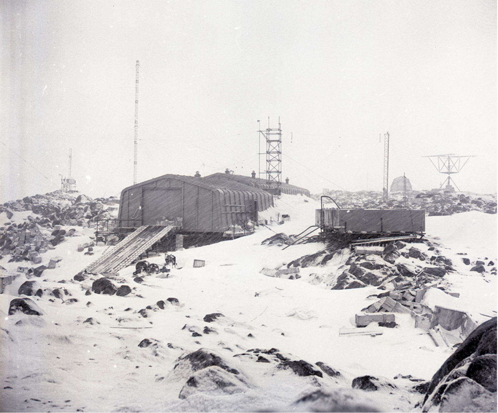
France’s IGY programme in Antarctica was directed by Bertrand Imbert, a hydrographer and veteran of earlier French campaigns in Terre Adélie, and run by Expéditions Polaires Françaises – the only organisation in France with the logistical know-how to operate in the Antarctic. The lead team arrived in Terre Adélie on New Year’s Day, 1956, aboard a vessel leased from Norway. It had been three years since the French had last set foot in the territory. The team’s first order of business was to build a new base to replace Port Martin. Named Dumont-d’Urville, it was located on Ⓘle des Pétrels, one of the rocky islands of the Géologie archipelago (Fig. 3). During the IGY, France conducted extensive scientific activity both at Dumont-d’Urville and at a smaller inland station named Charcot, as well as during inland traverses (Jardel, Reference Jardel1960).
Dumont-d’Urville base during the winter of 1957. (Base Dumont d’Urville, 1957, Expéditions Polaires Françaises, IPEV – Plouzané, DDU.57.06821).
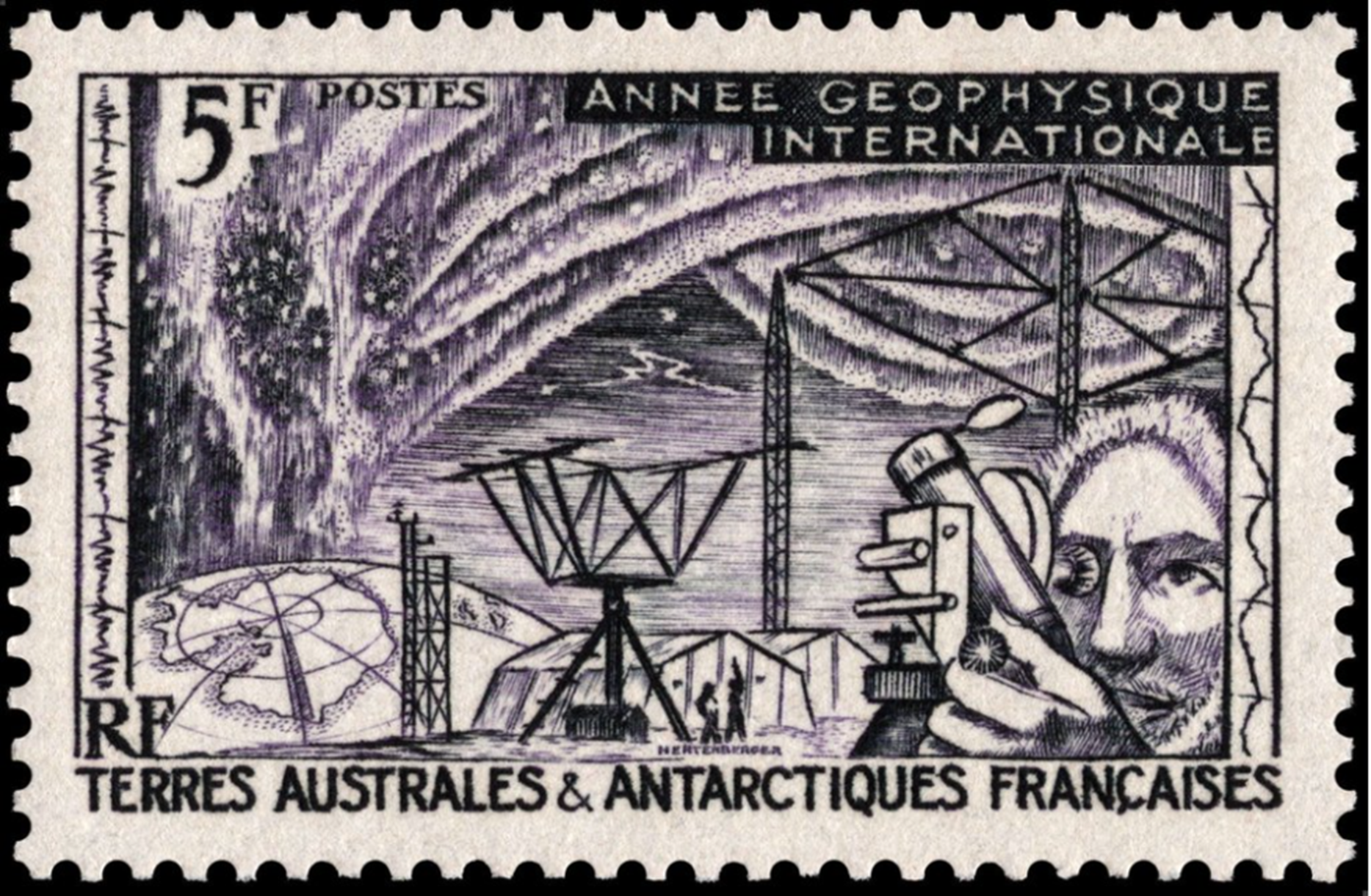
Even though the IGY was designed to be apolitical, and there was tacit agreement amongst the participating nations that political arguments were to be put to the side for its duration, still performances of sovereignty were common (Beck, Reference Beck1986). For Imbert, the overwinters at Station Charcot were not debatable despite their risks: France needed to be present in the continent’s interior, a need as essential for political considerations as scientific ones. Overwintering in the interior would prove French capability on the ice sheet, demonstrate the success of made-in-France polar technologies and send a clear message about future ambition. France also issued a new postal stamp showing a map of Antarctica with Terre Adélie highlighted alongside scientific instruments representative of the IGY (Fig. 4) and pushed a vision of a strong France in the Antarctic publicly.
French stamp for the International Geophysical Year showing Terre Adélie in the bottom left.
While the French government funded these activities, there was no commitment to continue supporting French presence in Terre Adélie after the IGY. Indeed, the initial plan had been to abandon the bases at the end of the IGY. But Victor, still fuming from the aftermath of the Port Martin fire, refused to hear of it. Supported by TAAF, Victor pleaded his case to the government. He gained a short reprieve in July 1958, winning permission for one more year in Terre Adélie, but was not given additional funding. The next overwinter was a reduced campaign with the simple goal of maintaining the Dumont-d’Urville base.
During this initial post-IGY year, President Eisenhower invited the 11 other countries active in the Antarctic to Washington to negotiate an agreement for managing the continent. The Antarctic Treaty negotiations forced France to make decisions about Terre Adélie. Together, the continuation of Antarctic research by other countries after the end of the IGY and the treaty negotiations made France realise that sovereignty could not be assured by sporadic presence; rather, to secure its rights in Terre Adélie, France needed to maintain continual presence. Led by Pierre Charpentier – an ambassador, experienced trade negotiator and diplomatic advisor – the French delegation came out in favour of demilitarisation and of the idea of Antarctica as a continent dedicated to science. France was, however, concerned that a perpetual freezing of sovereignty rights would represent a renunciation of its territorial claim. France eventually agreed to this freezing by interpreting it as having no effect on its claim to Terre Adélie. Charpentier made this point clear at the end of the negotiations, asserting that “[o]n the occasion of signing the Antarctic Treaty, the Republic of France reaffirms the sovereignty that she exerts over Terre Adelie” (Charpentier, Reference Charpentier1971; TAAF, 1960, p. 7). This is the “miracle” of the Antarctic Treaty: deliberate ambiguity on the sovereignty question allowed each country involved to interpret the treaty in a manner satisfactory to its own interests.
With the inauguration of the Fifth Republic and the return of General de Gaulle as president at the very end of 1958, Victor found the political opening he needed to secure long-term commitment to Terre Adélie. De Gaulle was motivated by the negotiation of the Antarctic Treaty as well as by growing American activity in Antarctica. While still remaining its ally in the Cold War, de Gaulle systematically distanced his country from the United States in order to underline France’s independence. In the Antarctic context, this manifested itself as not wanting to depend on the United States to affirm French rights in Terre Adélie. By committing to continual French presence in Antarctica, de Gaulle contributed to his dual goals of demonstrating France’s independence and boosting his country’s national pride at a time of immense change. As French colonies increasingly moved towards independence, the TAAF districts, with no indigenous populations, stood out as secure overseas regions: remote, often overlooked, and yet increasingly relevant to de Gaulle’s desire for France to remain a puissance mondiale moyenne (middle-sized world power).
Since signing the treaty, France has been actively engaged in the Antarctic Treaty System (ATS), hosting meetings and assuming leadership positions, determined to maintain an authoritative voice in Antarctic affairs and particularly in shaping how Terre Adélie is perceived internationally. The ATS is paramount to French national interests in the Antarctic: it is the mechanism by which France feels best able to wield authority over Terre Adélie itself and the management of the continent more broadly. In practice, France has insisted that continual presence in Terre Adélie is the third essential step, after discovery and formal claim, for sustaining and defending French sovereignty over the territory. “France consented freely to limit her rights by collective agreement but she has absolutely not renounced her sovereignty over Terre Adélie”, asserted the director of legal affairs at the Ministry of Foreign Affairs in a representative statement (cited in Guillaume, Reference Guillaume1987, p. 35). With this in mind, France has maintained continual presence at the Dumont-d’Urville base from 1955 to the present day. Nonetheless, the treaty has had practical impacts on France’s governance of Terre Adélie.
Underpinned by new commitment, the 1960s saw a steadiness and maturity in French Antarctic affairs. The Antarctic Treaty provided a path for the continent’s future, making clear that science would play a predominant role, and science was one of France’s strengths in the region. Activities at the Dumont-d’Urville base shifted from individual projects and campaigns to long-term strategies. Victor drew up infrastructure plans for new buildings and facilities, and the base was expanded (Fig. 5). More broadly, the French hosted the Antarctic Treaty’s Fifth Consultative Meeting in Paris in November 1968. Economic growth at home meant that money was available to back up the political will to maintain a presence in Antarctica – even if the amount provided was never enough to satisfy everyone. In this decade, Expéditions Polaires Françaises began to rely more on government funding and less on private funds. Now, credibility and a strong voice in the Antarctic depended on scientific work and logistical capacity. France excelled at the first but suffered from logistical shortcomings and – contrary to de Gaulle’s desires – was forced to rely on help from the United States. Tensions also rose between Expéditions Polaires Françaises and TAAF in the 1960s as Victor pushed back against what he saw as TAAF’s encroachment on his mandate (Victor, Reference Victor1961). Despite this, the decade was the calm before the storm.
Dumont-d’Urville base in summer 1965. In the foreground is the new scientific laboratory (Labo 2); further back, the new generating facility as well as the original IGY buildings can be seen. (Les bâtiments rénovés de la station Dumont d’Urville, 1965, Expéditions Polaires Françaises, IPEV – Plouzané, DDU.65.01269).

A crisis arises
In the 1970s, Terre Adélie began to face challenges as TAAF became mired in financial trouble. Between 1972 and 1979, the enormous costs of leasing ships to service the TAAF districts pressed hard, consuming over half of TAAF’s budget. By the end of decade, TAAF was deeply in debt (Barberot, Reference Barberot1979; Note à l’attention de M. Diefanbacher, 1979). For Terre Adélie, the combined costs of maritime servicing and salaries exceeded the territory’s budget allocation. Expéditions Polaires Françaises was forced to cut their scientific programmes and reduce staffing levels at the Dumont-d’Urville base by a third.
TAAF was in crisis. Unable to fulfil its missions, the president of TAAF’s consultative council wrote to Prime Minister Raymond Barre in the spring of 1979 with a stark message: unless France committed more money to TAAF, the Dumont-d’Urville base would have to close, France would most likely pull out of the Antarctic altogether, and would be forced to cede Crozet to a friendly nation (Président—Conseil consultatif TAAF, 1979). The question that emerged from this crisis was whether French presence in the Antarctic was desirable and sustainable – and, if so, how the costs would be met.
Supporters of Terre Adélie, including Bernard Vinay, the Inspector General for Overseas Affairs who was ordered to investigate the situation, highlighted the prestige and influence that France gained from its Antarctic presence. As more and more countries became active on the continent – with work which was in principle scientific but which in practice had political implications – French authority in Antarctica was at stake, Vinay reported. It was “inconceivable” for France to give up on her Antarctic base, he insisted (Vinay, Reference Vinay1979, p. 95). The choice was simple, he concluded: either the government needed to provide more money for TAAF or the Dumont-d’Urville base would have to close – and France’s role in the Antarctic would end. The Ministry of Foreign Affairs concurred (Heckel, Reference Heckel1979). An old Indochina and Africa hand, Vinay had been struck personally by the collapse of the French empire. As such, he was a natural ally of TAAF, sympathetic to both the specific challenges faced in Terre Adélie and the broader desire to keep France’s remaining overseas possessions secure.
But not all in the French government saw TAAF and Terre Adélie as the victims of too little funding. At the Overseas Ministry, TAAF’s problems were seen as the result of poor leadership and management. (As this ministry’s name and structure changed several times throughout the period of interest here, I will simply refer to it as the Overseas Ministry.) The ministry’s opinion of TAAF was scathing. In 1979, ministry official Jean Chaussade listed a litany of problems: the secretary general wasn’t being informed about the territory’s files; the technical service was understaffed; TAAF’s bases were poorly managed; financial decisions did not follow the territory’s governing rules; and so on (Chaussade, Reference Chaussade1979). The minister himself weighed in, arguing that French scientific research in Terre Adélie did not focus sufficiently on economic development (Note avec décisions, 1979; Note pour Monsieur le Ministre, 1979). This represents a different view of TAAF’s mission and priorities. By de-emphasising basic science and instructing TAAF to pursue economy- and resource-based science, the ministry focused its attention on the sub-Antarctic TAAF districts, which had more potential resources than Terre Adélie – including krill, algae, alginates and fish. The questions raised by the ministry were broad and strategic: How much emphasis should be given to each of TAAF’s four missions? What direction should TAAF’s scientific work take, and who should decide? Was Terre Adélie worth the expense, or should resources be focused on the other TAAF districts?
Given the particularities of the Antarctic, supporting Terre Adélie meant supporting Antarctic science: science was both at the heart of France’s claim to presence in Terre Adélie and central to the international conception of Antarctica. France’s future as an Antarctic player, TAAF’s chief administrator Roger Barberot argued, was linked to the question of scientific priorities: was Antarctic science a field in which France wanted to be competitive on the international scene (Barberot, Reference Barberot1979)? While French Antarctic geophysics, oceanography and biology were strong, this work was adversely affected by TAAF’s budgetary crisis. If France wanted to boost (or even maintain) its scientific contributions and prestige in Antarctica, more funding was needed.
Aware of the depth of these problems, TAAF turned to an outsider – an accomplished scientist, not a government administrator – to turn things around. In 1980, Bernard Morlet, a high atmosphere physicist and a veteran of several campaigns in Terre Adélie, was named to head TAAF’s research mission (Fig. 6). With his decades of experience in the region and his immense scientific competence, the hope was that he could turn a new page for TAAF. Morlet took to his role with enthusiasm and energy. He soon reassessed TAAF’s research mission, created scientific and environment committees within TAAF and reorganised Expéditions Polaires Françaises, all with the aim of better evaluating scientific priorities and budgets – a deliberate effort to respond to the complaints from the Overseas Ministry (Morlet, Reference Morlet1987, pp. 54–55).
Bernard Morlet (middle) in the Dumont-d’Urville base’s ionospheric laboratory, summer 1968. (Dans le labo ionosphère (bâtiment n°25): Guy Penazzi, Bernard Morlet et Christian Sinet, 1968, Robert Guillard, IPEV – Plouzané, SCI.73.65045).

But still Morlet could not secure more money for Terre Adélie. Despite his interventions, the budget woes worsened through the 1980s. In the middle of that decade, Expéditions Polaires Françaises again had to reduce its scientific work and let staff members go (Expéditions Polaires Françaises, 1985; Projet de budget des TAAF, 1984). Vice Amiral d’Escadre Claude Pieri, TAAF’s chief administrator and a former commander of France’s submarine fleet, wrote to the Secretary of State for Overseas France to warn that the present situation meant “a significant step backwards for French presence in Antarctica in terms of sovereignty as well as in terms of scientific research” (Pieri, Reference Pieri1985). “It is illusory to think that this privileged situation [i.e., France’s position in Antarctica] can be maintained in the face of growing international pressure, with decreasing means”, he continued. Not only was Pieri’s plea for a budget increase rebuffed; in fact, the Overseas Ministry reduced TAAF’s funding. Whereas the Overseas Ministry had provided TAAF with FF103 million in 1980, by the end of the decade, they only gave FF75 million (all in 1990 francs, adjusted for inflation).
By this time, TAAF’s problems had been ongoing for almost two decades. The Overseas Ministry ordered a full audit of the territory. The auditor’s report, released in March 1989, was damning (Rapport 5313, 1989). The auditors lent weight to the ministry’s dissatisfaction by noting that TAAF’s financial management was inadequate, as was Expéditions Polaires Françaises’ accounting (Analyse comptable, 1990; Maurin, Reference Maurin1991). The auditors also questioned TAAF’s legal ability to conduct scientific research, arguing that TAAF had assumed research responsibilities that were not explicitly given by its 1955 founding legislation. For Morlet, alarm bells were ringing: the inadequacy of TAAF’s founding texts vis-à-vis TAAF’s actual research activity gave critics a legal mechanism for taking research away from the territory.
Morlet responded carefully to the auditors’ report: he needed to shape the narrative or risk TAAF being sidelined (or worse). Morlet agreed with the auditors that, read narrowly, TAAF’s legal texts were incompatible with the modern conception of research that was being practiced in Terre Adélie (Morlet, Reference Morlet1989a). Changing the 1955 legislation, however, was not an option as it would require reaffirming France’s sovereignty over Terre Adélie, which was now complicated by the Antarctic Treaty. Presciently, Morlet worried that the ministry would respond to the auditors by creating a new polar organisation to take over TAAF’s research mission. By linking science to sovereignty, Morlet sought to argue that TAAF and science could not be separated without damaging France’s claim to sovereignty in Terre Adélie. In this view, scientific research was the most certain expression of sovereignty in Terre Adélie – a joint mission that Morlet hoped would guarantee TAAF’s survival.
Terre Adélie in context
To understand the Overseas Ministry’s position, we need to consider Terre Adélie’s situation vis-à-vis France’s other overseas interests. The strategic, economic or political utility of most of France’s possessions is clear. Building French societies overseas, and in particular rayonnement (the diffusion and influence of French language and culture), was a priority for the Overseas Ministry – but this only applied to populated possessions. Some possessions offered economic advantages, such as nickel in New Caledonia. And French Polynesia was a geostrategic asset as the location of French nuclear testing after Algerian independence. From this point of view, Terre Adélie was an outlier. With no electorate to push its interests and all but no economic potential, Terre Adélie was fundamentally different from France’s other overseas possessions. The strategic and political advantages Terre Adélie offered to France were difficult to measure and hard to explain in concrete terms. In all these ways, Terre Adélie held little cultural, diplomatic, economic or strategic importance to the ministry. Further, in the 1970s and 1980s, the Overseas Ministry was consumed by unrest in the French Pacific territories, including a militant nationalist movement in Melanesia and rebellions which twice brought New Caledonia to the brink of civil war. These urgent problems shunted the Antarctic to the background and left little time or money for Terre Adélie (Le Pensec, Reference Le Pensec1989).
The ministry’s attitude towards Terre Adélie was an extension of a long history of disinterest towards the territory, especially by conservative governments. In 1954, for example, the finance commission complained that Terre Adélie was home to only a few Frenchmen who were posted there temporarily, and some penguins (Les sénateurs ajournent l’examen du statut, 1954). That France’s strategic priorities didn’t include the Antarctic, Marie Françoise Labouz has pointed out, is evident from budget comparisons, which show that France’s Antarctic budget was half or less than that of the other Antarctic Treaty consultative parties (Labouz, Reference Labouz1992, p. 42). This disinterest was not challenged by the French public, for whom the Antarctic attracted only sporadic attention. “We are not taken seriously” and “Antarctic research doesn’t interest anyone at the DOM-TOM [the Overseas Ministry]”, complained Expéditions Polaires Françaises, lamenting the reality of the situation – that Terre Adélie had no political clout (La débâcle, 1991).
On the other hand, Terre Adélie contributed to grandeur (greatness): France’s pride and place in the world, which has long been central to its self-image. France’s early overseas activities were based on the desire to seek strategic, commercial and political benefits to boost its global power – objectives that were “originally based on a quest for knowledge and wealth, accompanied by a competitive objective for its cultural influence to prevail”, as Denise Fisher writes (Cornevin & Cornevin, Reference Cornevin and Cornevin1990; Fisher, Reference Fisher2013, p. 238). In the 18th and early 19th centuries, France had been the predominant force in Europe. As France lost authority and territory in Europe in the 19th century, it attempted to expand its overseas activities to make up for the losses – an approach that was challenged by decolonisation after World War II. By the early 1960s, France’s overseas empire was greatly reduced, and with the independence of the Comoros, Vanuatu and French Somaliland (Djibouti) in the following two decades, by the 1980s France was left with only a very few overseas possessions. In this context, France’s remaining possessions were important symbols of international status and credibility. As former Prime Minister Raymond Barre said, “whatever the cost, our overseas possessions assure us of a global dimension which is fundamental to us” (cited in Chesneaux, Reference Chesneaux1992, p. 99). Without these possessions, France would, as Stephen Henningham reminds us, “slip to the middling rank of powers, consistent with its size and relatively modest economic strength, despite its rich cultural heritage and proud memories” (Henningham, Reference Henningham1992, p. 193). France’s history as a country of empire still carries weight, and the remaining outposts – amongst them, Terre Adélie – give France an internationally recognised presence far from the Hexagon, contributing to national prestige and identity. It was this end that sustained Terre Adélie through the 1970s and 1980s when the Overseas Ministry had other concerns and priorities.
Polar dreams, polar science
In the 1980s, French polar scientists felt the effects of Terre Adélie’s financial problems deeply. While France had enjoyed success and acclaim in Antarctic science in the 1970s and 1980s, it was tempered by constant worries about funding, logistics and facilities. TAAF had long not been able to provide Expéditions Polaires Françaises with the money needed to conduct vigorous, wide-ranging scientific programmes, nor the funds to build modern laboratories at the Dumont-d’Urville base. More broadly, the traditions of France’s polar pioneers were in danger of being lost as French commitment to these regions floundered.
As the decade progressed, French Antarctic scientists spoke out about their frustrations (e.g. Actes du colloque, 1984). Their grievances were legion. The biological science building in Terre Adélie didn’t have running water. Contractual terms for French scientists working in Terre Adélie left much to be desired. France lagged behind other countries in terms of Antarctic geology. While the French had pioneered ice core drilling in Greenland and Antarctica, French logistics in Antarctica weren’t capable of handling deep drilling: French ice core work was only possible with logistical support from the United States. French astronomers and astrophysicists saw Terre Adélie as an ideal observation site, but TAAF didn’t have the means to open the Dumont-d’Urville base to them. A team from the Nice Observatory travelled instead to an American Antarctic base for their research, again emphasising the logistics gap between the United States and France (Morlet, Reference Morlet1987).
There was also a widespread feeling amongst civil servants, politicians and scientists that French Antarctic research could only find new momentum by building an airstrip near the Dumont-d’Urville base. The airstrip project, which stretched from the late 1960s to the early 1990s, consuming well over FF100 million despite never being used, was seen as a panacea to a host of problems facing Terre Adélie: the onerous cost of ship servicing, the limitations to scientific campaigns dictated by Terre Adélie’s natural environment, the safety of personnel on the ground, French competitivity in Antarctic affairs and the security of France’s claim to sovereignty over the territory (author’s paper – forthcoming).
The situation was even worse in the Arctic, where France claimed no territory and had no body corresponding to TAAF to promote French research at all. While France had been active in the Arctic earlier in the 20th century, by 1990, France conducted essentially no independent Arctic research (Ministère de la Recherche et de la Technologie, 1989). The feeling that France had lost its position in Arctic science and exploration was particularly visible through the lens of France’s fight to be included in the International Arctic Science Committee, founded in 1990 (Lorius, Reference Lorius1989). If France wanted to contribute to solving major problems in the fields of polar climatology, glaciology and atmospheric dynamics, scientists and government officials needed to come together and build a stronger system; there needed to be consensus on objectives and solidarity in terms of means.
An environmental approach
Through the 1980s, Terre Adélie’s situation gradually worsened. But at the very end of the decade, President François Mitterrand and Prime Minister Michel Rocard intervened in Antarctic affairs, redefining France’s political strategy on the white continent.
In 1989, negotiations over an Antarctic minerals convention came to an end after six years of intense effort. The proposed convention, the Convention on the Regulation of Antarctic Mineral Resource Activities (CRAMRA), was planned as an addition to the Antarctic Treaty to control the exploration and exploitation of minerals on the continent (Bermejo, Reference Bermejo1990). But instead of ratifying the convention, as expected, Mitterrand made a volte-face and rejected CRAMRA: “I am preoccupied by the safeguarding of the Antarctic continent”, he said, and with the “idea of transforming this continent into a vast natural and peaceful reserve” (JO Sénat, 1989, p. 1932; Le Déaut, Reference Le Déaut1989). In making his decision, Mitterrand had been strongly influenced by Jacques Cousteau, the famed French naval officer, explorer and conservationist, and by his prime minister, Rocard, who described protecting Antarctica’s environment as “my most fervant desire” (La conférence sur l’Antarctique, 1989).
Soon, France (together with Australia) proposed a comprehensive regime for the protection of the Antarctic environment, including the prohibition of mining and the declaration of the continent as an international wilderness reserve. Known as the Madrid Protocol, it was signed in 1991 and came into force in 1998 (Elliott, Reference Elliott1994). With the push for an environmental protocol in the Antarctic, and especially with the environment acting as the public face of the reasoning behind France’s rejection of CRAMRA, France staked a claim: after years of being considered as one of the least pro-environment countries in the ATS, France was now committed to protecting the Antarctic environment.
Mitterrand and Rocard’s championing of the Antarctic environment was thoroughly strategic, underpinned by sovereignty considerations and by domestic politics (author’s paper – forthcoming). In terms of sovereignty, senior figures in the French government came to see a pro-environment stance in Antarctica as the most effective way of protecting France’s claim to Terre Adélie. In the late 1980s, the environment came to matter in a way it hadn’t earlier in the decade, and developing countries and ENGOs who had long been focused on Antarctica found their leverage. Led by Malaysia, which had for years campaigned against the ATS, developing countries used the environment as a pressure point to push for changes to Antarctica’s management – changes which threatened the authority of the claimant states (amongst them, France) (Peterson, Reference Peterson1988). They argued that the ATS would not be able to make good on CRAMRA’s safeguards and portrayed the convention as a “slippery slope” leading to environmental degradation in the Antarctic (Barnes, Reference Barnes, Jorgensen-Dahl and Østreng1991; Herber, Reference Herber1991). France saw these arguments as serious challenges to its claim over Terre Adélie and to the ATS’s legitimacy in Antarctic affairs (Ministère des Départements et Territories d’Outre-Mer, 1989a, 1989b). By rejecting CRAMRA and championing a convention for environmental protection within the existing treaty system, France and Australia negated the environmental arguments for the creation of a new supranational control authority for the Antarctic (for Australia, see Bergin, Reference Bergin1991). In this way, France retained legitimacy on the Antarctic political scene and secured its rights in Terre Adélie. While it is beyond the scope of this paper, it should be noted that a similar focus on sovereignty was at play in the French negotiating position for the Convention for the Conservation of Antarctic Marine Living Resources at the end of the 1970s (Oraison, Reference Oraison2005).
In domestic political terms, electoral pressure from the ecological movement and from pro-environment voters was critical to making the environment matter on the French political agenda in 1989. On the European front, pollsters predicted dramatic breakthroughs for green parties in the mid-1989 European parliamentary elections. Mitterrand’s rejection of CRAMRA was part of his strategy for these elections, designed to attract potential green voters. Domestically, too, green candidates were gaining, especially in municipal elections, in what Brendan Prendiville has called a “green wave” sweeping over France (Bennahmias & Roche, Reference Bennahmias and Roche1992; Prendiville, Reference Prendiville1994, p. 45). Mitterrand’s refusal to ratify CRAMRA was part of his effort to counter this momentum. As Mitterrand and Rocard put the Antarctic environment into the spotlight, Terre Adélie came to matter in France in a way it hadn’t before.
Reorganising polar research in France
Just weeks after Mitterrand rejected CRAMRA, the Overseas Minister and the Minister for Research and Technology demanded an evaluation of France’s polar activities. Delivered two months later by Claude Fréjacques (President of CNRS) and Frédéric Thiriez (Director of Political, Administrative and Financial Affairs at the Overseas Ministry), the report was condemnatory. France was weak in both Arctic and Antarctic affairs, the men wrote, with a worryingly low polar budget. France used to be a strong player in Arctic research, but “has now been reduced to participation in a few operations here and there via international collaboration” (Fréjacques & Thiriez, Reference Fréjacques and Thiriez1989). French Antarctic science, too, was poorly supported and international partners were beginning to turn away, Fréjacques and Thiriez continued. They then linked the two polar worlds, recommending that France establish a new organisation to cover both polar regions. The idea of such an organisation had been floated for a while, but had not been championed by anyone until Fréjacques and Thiriez’s report. Propelled by Mitterrand’s stake in the Antarctic environment, the ministries took up this call with enthusiasm, hoping that “the conditions will come together for French polar research to have a new momentum and for our country to preserve its place in this peaceful competition between nations, that is to say amongst the first” (Ministère des Départements et Territories d’Outre-Mer et Ministère de la Recherche et de la Technologie, 1990).
At the same time, the ministries saw a new structure for French polar research as a solution to their frustrations with TAAF: as envisioned by the ministries, the new organisation would take control over Antarctic research away from TAAF (Praderie, Reference Praderie1991). Even the link between the Arctic and Antarctic was a way of pushing TAAF to the side: since France had no territorial possession in the Arctic region, the ministries argued, TAAF could not take on the role of an interlocutor with foreign partners in that region – and thus TAAF could not have a leading role in the new organisation (Ministère de la Recherche et de la Technologie, 1990). At TAAF, Morlet was acutely aware of the political implications of these events. He rightly recognised them as a mechanism for sidelining TAAF, for removing its control over its scientific mission, for punishing it in the wake of the auditors’ report. Morlet again played his trump card, arguing that TAAF could not be disconnected from research since science was the means by which TAAF assured French sovereignty over Terre Adélie, but he failed to sway the ministries (Jouventin, Morlet, & Trehen, Reference Jouventin, Morlet and Trehen1990; Morlet, Reference Morlet1989b).
In January 1992, the new polar organisation, called Institut Français pour la Recherche et la Technologie Polaire (IFRTP, French Institute for Polar Research and Technology), was created. It brought together the Overseas Ministry, the Ministry of Research and Technology, TAAF’s research arm, Expéditions Polaires Françaises and several other French scientific bodies under one roof, finally bringing French Antarctic activity into the governmental fold. IFRTP was charged with selecting and financing scientific programmes for the polar and subpolar regions, organising expeditions, participating in international scientific work, managing laboratories and building a research station in Antarctica’s interior. Morlet was pushed aside because he had become the face of TAAF’s problems – something which he looked back on bitterly for the rest of his life. In 2002, IFRTP’s name was changed to Institut Polaire Français Paul-Emile Victor (IPEV, French Polar Institute Paul-Emile Victor), in honour of the dean of modern French polar work, who had passed away seven years earlier.
Following the narrative to the present day
Since the early 1990s, the environmental approach that followed from Mitterrand and Rocard’s rejection of CRAMRA and France’s sponsorship of the Madrid Protocol has provided a clear narrative for France’s course in the Antarctic. It has not, however, put an end to the peaks and troughs of the preceding decades. More recently, high-level concern over Antarctic geopolitics has emerged, sending signs that France is eager to revitalise its political stance in the Antarctic.
The creation of IFRTP did give a boost to French Antarctic science, and France remains a significant actor in that field. In collaboration with Italy, IFRTP built a scientific station in the interior of the Antarctic continent – something French scientists had long hoped for. It opened as a summer scientific station in 1996 and a year-round facility in 2005. The station, called Concordia, represents a place where the French government can stake out its environmental position in Antarctic research. France is also a leader in the ambitious Beyond EPICA ice core drilling project, which aims to retrieve a 2.7-kilometre long ice core and shed new light on the Earth’s climate history. Begun in 2019, Beyond EPICA’s first results are expected in 2025. It is clear that the French government continues to see Antarctic research as a potent political symbol, a means of showing that France is “powerful and scientifically sophisticated” (Gaudin, Reference Gaudin2007, p. 100).
But the political and institutional bickering that so coloured France’s polar efforts for decades has persisted. The two main players in French polar work, IFRTP/IPEV and TAAF, have continued to disagree, especially in areas where their mandates overlap. Auditors’ reports repeatedly stress that the lack of clarity surrounding these mandates is causing duplication, confusion and waste, even going so far as to call on the Prime Minister’s Office to step in and regularise Terre Adélie’s management (Cointat, Reference Cointat2007; Cour des comptes, 2005, pp. 448–458).
The old funding problem persists, too. While the crisis of the 1970s and 1980s has abated, still France’s investment in Terre Adélie remains significantly lower than that of other countries with Antarctic interests, something which is regularly pointed out in the National Assembly, by scientists, in government reports and in the media. Terre Adélie’s budget is strained and the Dumont-d’Urville base suffers from neglect, with serious sanitation and maintenance problems. “The Dumont-d’Urville base is the major symbol of our presence”, wrote Christian Gaudin of the Parliamentary Office for the Evaluation of Scientific and Technological Choices in 2007: “It is our duty to have a station in line with our rank and not a disorganised series of dilapidated buildings” (Gaudin, Reference Gaudin2007, p. 125). The base has not greatly improved since then. Earlier this year, France’s lagging research funding for and investment in the Antarctic, and the consequences thereof for France’s ability to retain influence in Antarctic affairs, were again raised in the Senate (Fernique, Reference Fernique2021, p. 1536; Lopez, Reference Lopez2021, p. 1267)
France also still suffers from weaknesses in logistics. The new French icebreaker, the Astrolabe, developed a major defect during its first trip to Terre Adélie in late 2019. As a result, planned scientific work was cancelled and the French were forced to rely on Australia to service Terre Adélie. As pointed out in the National Assembly, this meant that the servicing of a French territory was entrusted to a foreign country, a “critical situation which puts research and French sovereignty in the TAAF in danger” (Lagleize, Reference Lagleize2020, p. 981). France is also the only country highly active in the Antarctic with no aviation capacity to access the continent. To the Foreign Affairs Commission, which reported in 2019, the access problem speaks to a quintuple weakness: reliance on foreign nations; inadequate servicing of a French territory; limitations on science and cooperation; danger to personnel on the ground; and a blow to France’s legitimacy in Antarctic affairs (Commission des Affaires Etrangères, 2019a, p. 104ff).
These problems are best summarised by Jérôme Chappellaz, IPEV’s director, who noted in 2019 that “[t]he miracle cannot continue”: that is, unless more resources are committed, French Antarctic science will inevitably decline. “What we are asking [us] to accomplish with the means provided today is becoming untenable”, complained Chappellaz (Commission des Affaires Etrangères, 2019b; also see Berger, Reference Berger2019; Dessibourg, Reference Dessibourg2020). “A central question today is, ‘Do we still want to play a role in the Antarctic?’”, he continued. If more investment is not forthcoming, “not only will we lose our rank as a nation currently located at the forefront of scientific production in Antarctica, but France’s weight in the Antarctic diplomatic context as well as its initial claim of sovereignty in Adélie Land could be called into question”. These are exactly the same questions that were asked through the 1970s, 1980s and into the 1990s. In particular, Chappellaz’s appeal to the sovereignty question to push for additional funding recalls Morlet’s efforts to link sovereignty and science in the 1980s and early 1990s.
Recently, however, there have been signs of greater positive engagement with the Antarctic. While there has long been broad agreement on the fundamental national interest of retaining Terre Adélie, in recent years, this has begun to be re-strategised. In the past six years, Chinese and Russian actions have sparked high-level concern over France’s political strategy for the Antarctic. In 2019, Prime Minister Edouard Philippe made clear France’s mistrust of Chinese intentions in the Antarctic, pointing to the lack of transparency at the Kunlun Station (Philippe, Reference Philippe2019). Russia’s intentions, too, and specifically the concern that Russia is looking to exploit mineral resources in the Antarctic, counter to the Madrid Protocol, have gained high-level attention in France (Gaymard & Mamère, Reference Gaymard and Mamère2015). These perceived threats have fed a growing French desire to reinforce sovereignty over Terre Adélie and to push the “science and peace” agenda of the ATS, a system in which Franch is highly invested.
In recent years, too, France has been actively engaged in negotiations for regulating Antarctic tourism and defining new protected marine reserves in the Antarctic region. Determined to prevent tourism from becoming an economic activity that endangers the Antarctic ecosystem and, more importantly, from becoming a vector for challenges to French sovereignty in Terre Adélie, French negotiators have been pushing for strict limits on tourism (Commission des Affaires Etrangères, 2019a, p. 87ff; Gaymard & Mamère, Reference Gaymard and Mamère2015). In keeping with its environmental stance, too, France has been pushing hard for the protection of eastern Antarctic waters. As China and Russia have stymied these efforts, and explicitly opposed the creation of a protected marine reserve next to Terre Adélie, the French government has recognised that France needs to step up to protect its strategic interests. The Russian and Chinese opposition is entirely political, emphasised the Foreign Affairs Commission in 2019, demanding an equally strong political response from France (Commission des Affaires Etrangères, 2019a, p. 106). As the Minister for Ecology, Barbara Pompili, noted earlier this year, France is continuing to fight this battle (Pompili, Reference Pompili2021).
This recent desire to revitalise France’s political stance in the Antarctic has led to a number of practical results. In mid-2019, the National Assembly set up an information mission to define a strategic vision for French presence in the polar regions. Later that year, France sent a minister to Terre Adélie for the first time. The visit of the Minister of Higher Education, Research, and Innovation was a calculated gesture intended to underline France’s commitment to Antarctic research and marine protection at a time of increasing tension. And in late 2020, after a brief hiatus following the controversy with Ségolène Royal, France appointed its third ambassador for the polar regions, diplomat and writer Olivier Poivre d’Arvor, whose mission expressedly includes producing a roadmap for French polar strategy by the end of this year. Together with France’s recent strategic plans for the Austral Oceans and for the Arctic, this offers an opportunity for France to define a stronger political strategy for the Antarctic – one backed by high-level interest. Further, as many have pointed out, the upcoming French presidency of two international conferences linked to Antarctic geopolitics in June 2021 (the 43rd Antarctic Treaty Consultative Meeting and the 23rd Meeting of the Committee for Environmental Protection of the Madrid Protocol), offers a natural launch point for this re-strategisation. It remains to be seen how this will play out.
Acknowledgements
The author thanks Peder Roberts for the opportunity to work on the GRETPOL project.
Financial support
This project has received funding from the European Research Council (ERC) under the European Union’s Horizon 2020 research and innovation programme (grant agreement No. [716211 - GRETPOL]).
Conflict of interest
None.


 Open access