


1. Introduction
Geochronology carries essential information for paleoclimatic and paleoenvironmental reconstruction. The estimated ages provided by various dating methods and techniques allow deducing past environmental conditions and their development. There are more and more studies published, that combine radiocarbon dating and optically stimulated luminescence (OSL) results (Buró et al. Reference Buró, Sipos, Lóki, Andrási, Félegyházi and Négyesi2016; Crombè et al. Reference Crombè, Strydonck van, Boudin, Brande van den, Derese, Vandenberghe, Haute van den, Picon-Court, Verniers, Gelorini, Bos, Verbruggen, Antrop, Bats, Bourgeois, Reu, Maeyer, Smedt, Finke, Meirvenne van and Zwertvaegher2012; Kiss et al. Reference Kiss, Gy, Mauz and Mezősi2012, Reference Kiss, Hernesz, Sümeghy, Györgyövics and Gy2015; Miao et al. Reference Miao, Wang, Hanson, Mason and Liu2016; Nian et al. Reference Nian, Zhang, Wang, Sun, Chen, Chen and Hutchinson2017; Újvári et al. Reference Újvári, Molnár, Novothny, Páll-Gergely, Kovács and Várhegyi2014, Reference Újvári, Molnár and Páll-Gergely2016). Although several methods are available to study the chronology, the suspected age interval as well as the quality and quantity of accessible materials may influence the selection of appropriate procedures.
In a flood-plain environment, the dynamics of landform formation might be more variable/rapid than in other areas. Nevertheless, the evolution of river channels and flood plains over time have great significance in the study of environmental change, so this has received considerable international attention (Bertalan et al. Reference Bertalan, Rodrigo-Comino, Surian, Šulc Michalková, Kovács, Sz, Gy and Hooke2019; Shen et al. Reference Shen, Yu, Zhang, Zhao and Lai2015; Szabó et al. Reference Szabó, Vass and Cs2012). Sediments of different ages from distant areas can also transported to a flood plain by the flood events, which is why investigating the chronology of flood plains could be challenging for 14C dating. In this study, along with 14C dating, we also applied OSL dating technique to verify the 14C based chronology to gain a more reliable age profile. However, the correlation between these two different techniques is greatly influenced by the sample material (Miao et al. Reference Miao, Wang, Hanson, Mason and Liu2016). For example, Újvári et al. (Reference Újvári, Molnár, Novothny, Páll-Gergely, Kovács and Várhegyi2014, Reference Újvári, Molnár and Páll-Gergely2016) have published calibrated radiocarbon ages (gastropod and charcoal ages) that are much older than the OSL results for the Dunaszekcső loess sequence, which raises methodological questions.
Based on earlier hypotheses, hundreds of meters of Late Quaternary sediments might have been deposited in this area (Franyó Reference Franyó1992; Gábris Reference Gábris, Félegyházi, Nagy and Zs2001, Reference Gy, Mészáros, Schweitzer and Tóth2002; Nádor et al. Reference Nádor, Lantos, Tóth Makk and Thamóné-Bozsó2003; Rónai Reference Rónai1985; Timár Reference Timár2003; Vandenberghe et al. Reference Vandenberghe, Kasse, Popov, Markovic, Vandenberghe, Bohncke and Gy2018). It has been suggested that the thickness of Holocene sediments alone should be 30–40 m on top of the sediment profile (Kuti and Kőrössy Reference Kuti and Kőrössy1989).
Using absolute dating methods, we wanted to support and verify previous opinions regarding this area, which were based largely on geophysical, geomorphological and sedimentological observations. Only scattered reports of previous stratigraphic studies carried out with absolute dating are available from this area. Based on these, the abandoned river channels were created in the last 4–29 kyrs 14C years cal BP in the surroundings of the Tisza, Sajó and Bodrog, from the LGM to the new Holocene. In many cases, the estimation of the formation age of individual developmental stages and surfaces can only be linked indirectly with the results of 14C measurements carried out in more distant areas.
1.1 Research objectives
In this study, we aim to interpret our sediment dating results and fit them to the Late Pleistocene/Holocene history of the Jászság Basin, comparing them to the already published literature (Kuti and Kőrössy Reference Kuti and Kőrössy1989).
To achieve a reliable age-depth model, we replicated the dating of sediments in the middle section of the river Tisza with more advanced AMS radiocarbon dating, which involved the preparation of different fractions of soil organic matter and analyses of very small (< 0.1g) fossil remains (gastropods and charcoal fragments).
Radiocarbon dating of soils is mainly used for the chronology of soil development. In archaeological and environmental archaeological studies, if there are no fossil remains available for 14C measurements, there are a number of examples in the literature of the applications of bulk sediment 14C ages, where the reservoir effect can be taken into account (Harrison Reference Harrison1996; Wang et al. Reference Wang, Amundson and Trumbore1996; Brock et al. Reference Brock, Froese and Roberts2010). However, dating of bulk samples, particle size fractions, and organic matter fractions from soil samples has been carried out with only small and varying degrees of success in the last 20–25 years (Chichagova and Cherkinsky Reference Chichagova and Cherkinsky1993; Hemingway et al. Reference Hemingway, Rothman, Grant, Rosengard, Eglinton, Derry and Galy2019; Scharpenseel and Becker-Heidmann Reference Scharpenseel and Becker-Heidmann1992; Tamm and Östlund Reference Tamm and Östlund1960; Trumbore Reference Trumbore2000; Wang et al. Reference Wang, Amundson and Trumbore1996). The steady-state apparent radiocarbon age (reservoir-age) of living soils can be very different (from hundreds to thousands of 14C years cal BP) according to the geological location. This depends on the climate, parent material, precipitation, chemical environment, flora and many other parameters (Buró et al. Reference Buró, Lóki, Győri, Nagy, Molnár and Négyesi2019; Molnár and Svingor Reference Molnár and Svingor2011; Novák et al. Reference Novák, Molnár and Buró2018; Scharpenseel and Becker-Heidmann Reference Scharpenseel and Becker-Heidmann1992; Tóth et al. Reference Tóth2018; Wang et al. Reference Wang, Amundson and Trumbore1996). The 14C age of the soil organic carbon (SOC) pool is subject to many processes affecting the vertical and horizontal pattern of carbon in the soil and exchange between soil and biosphere (Doetterl et al. Reference Doetterl, Berhe, Nadeu, Wang, Sommer and Fiener2016; Wiaux et al. Reference Wiaux, Vanclooster, Cornelis and Van Oost2014). Various sources of carbon can modify the ratio of modern and older carbon in the composition of SOC (Hales et al. Reference Hales, Scharer and Wooten2012). An increasing age of soil organic carbon that parallels increasing distance from the soil surface is expected, since most sources of new carbon from roots exudation (Doetterl et al. Reference Doetterl, Berhe, Nadeu, Wang, Sommer and Fiener2016; Novák et al. Reference Novák, Molnár and Buró2018).
2. Study area
The research area is located in the Central Tisza basin of the Great Hungarian Plain, the Jászság Basin, which is one of the unevenly sinking basins of the Great Plain (avg. 3 mm/yr since the late Miocene) (Joó Reference Joó1992; Timár et al. Reference Timár, Sümegi and Horváth2005). In terms of its tectonics, it is formed by N-S-striking, young normal and strike-slip faults (deforming late Miocene, Pliocene, Quaternary layers, inactive today) normal and laterally displaced faults (Horváth and Tari Reference Horváth and Tari1999; Horváth et al. Reference Horváth, Bada, Windhoffer, Csontos, Dombrádi, Dövényi, Fodor, Grenerczy Gy, Szafián, Székely, Timár, Tóth and Tóth2006). The Great Hungarian Plain is one of the most beautiful examples of alluvial plains, which shows exceptionally small—sometimes less than 100 m—elevation differences. Sediments deposited mainly by running water in the Quaternary are responsible for its formation (Gábris Reference Gy, Mészáros, Schweitzer and Tóth2002; Gábris et al. Reference Gábris, Félegyházi, Nagy and Zs2001; Nádor et al. Reference Nádor, Lantos, Tóth Makk and Thamóné-Bozsó2003, Reference Nádor, Thamóné-Bozsó, Magyari and Babinszki2007; Thamóné-Bozsó et al. Reference Thamóné-Bozsó, Zs and Nádor2002; Timár et al. Reference Timár, Sümegi and Horváth2005; Vandenberghe et al. Reference Vandenberghe and van der Plicht2016, Reference Vandenberghe, Kasse, Popov, Markovic, Vandenberghe, Bohncke and Gy2018).
During the Pleistocene, the area of the Jászság Basin continuously sank, as a result of which riverine recharge was intense (Miháltz Reference Miháltz1967). Total thickness of the sediments deposited at that time exceeds 300 m.
The research area lies in the past flood plain of the river Tisza (altitude ∼85–90 mBf sea level above the Baltic Sea in meters). Its morphology has been shaped by the meandering Tisza and Zagyva Rivers, thus the surface is now covered by a rich network of abandoned river channels and oxbows.
The Paleo-Tisza flowed across the Nyírség alluvial fan in the direction of the Érmellék-Berettyó Rivers during the Pliocene (Borsy Reference Borsy1954; Borsy and Félegyházi Reference Borsy and Félegyházi1982; Sümeghy Reference Sümeghy1944). During the late Pleistocene, by avulsion, the river Tisza was able to reach its final position with the sinking of the Bodrogköz and the Bereg-Szatmári-plain (Borsy Reference Borsy1954, Reference Borsy1989; Nagy et al. Reference Nagy, Tóth and Sztanó2007). The Tisza is now further to the west than earlier and reached its present-day path between about 14 kyr (Gábris and Nádor Reference Gábris and Nádor2007) and 16–18 kyrs (Timár et al. Reference Timár, Sümegi and Horváth2005; Vandenberghe et al. Reference Vandenberghe and van der Plicht2016) ago. There might have been several meander cutoffs about 14 kyrs ago (or 16–18 kyrs ago) until the river finally shifted to its current position.
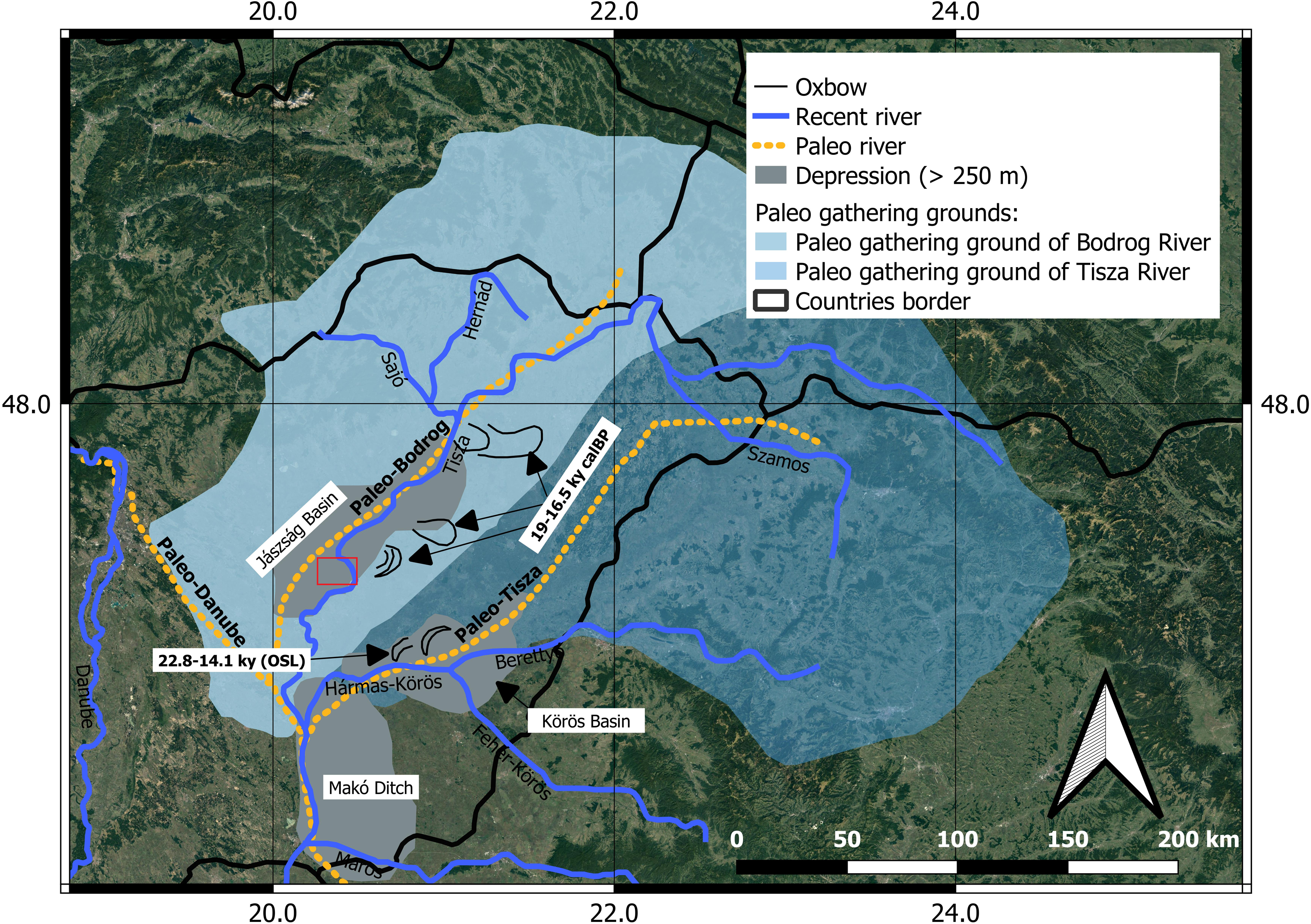
Based on the currently available age and climatic data, Gábris (Reference Gy, Mészáros, Schweitzer and Tóth2002) created a triaxial paleohydrological model for the late Pleistocene (Figure 1) (Gábris Reference Gy, Mészáros, Schweitzer and Tóth2002). They suggest that there was a third river, the “Paleo-Bodrog,” with notable water output next to the Paleo-Tisza and Paleo-Danube. The supposed sediments of the “Paleo-Bodrog” were found by Nagy et al. (Reference Nagy, Vajk, Tóth and Sztanó2005) below the present-day channel of the river Tisza. Figure 1. shows the age data of the subsurface and surface meander traces (Gábris and Nádor Reference Gábris and Nádor2007; Nádor et al. Reference Nádor, Lantos, Tóth Makk and Thamóné-Bozsó2003, Reference Nádor, Thamóné-Bozsó, Magyari and Babinszki2007). According to Gábris and Nádor (Reference Gábris and Nádor2007) 5 kyr ago, at the Atlantic/SubBoreal boundary, there was another change due to tectonics (Gábris Reference Gábris2011).
Hypothetical watershed and river channels (black dashed line) of the Paleo-Tisza, “Paleo-Bodrog”, Paleo-Danube and the present rivers Tisza (red square is the study area) and Danube. The age data shown in the figure are those of the subsurface and surface traces of the former abandoned meanders/(oxbows) (after Gábris and Nádor Reference Gábris and Nádor2007).
As a consequence of tilting of the Great Hungarian Plain, the meandering trail of the river Tisza gradually shifted westward (Mike Reference Mike1975).
During the Quaternary, major changes in the hydrological network were determined by high-frequency and high-amplitude instability of the climate manifested as alternating interglacial (warmer) and glacial (colder) periods. At the time of glacial periods, both shorter or longer high intensity colder (stadial) and warmer (interstadial) periods can be identified (Emiliani Reference Emiliani1955; Kretzoi and Pécsi Reference Kretzoi and Pécsi1982a, Reference Kretzoi and Pécsi1982b; Penck and Brückner Reference Penck and Brückner1901–1909; Shackleton Reference Shackleton1967; Shackleton and Opdyke Reference Shackleton and Opdyke1973). During the Holocene, the climate has been relatively more stable, but lower-amplitude climatic oscillations have still occurred.
The research area, together with the whole Carpathian Basin, was part of the periglacial belt during glacial periods of the Pleistocene, so contiguous ice cover affected the land surface only in the mountainous regions to the north. During the glacial period, the lowland areas were characterized by an extremely continental climate, with a high level of drought, which resulted in the preservation of records of aeolian processes, such as wind erosion, loess deposition, wind-blown sand (Fábián et al. Reference Fábián, Kovács and Varga2000; Gábris Reference Gábris2003; Horváth et al. Reference Horváth, Bradák, Novothny and Frechen2007; Jámbor Reference Jámbor2002). During interglacial warming, rainfall increased and the surface water and groundwater from the melting of the snow cover of the surrounding mountains (Carpathian Mountains) resulted in higher water abundance, thus facilitating alluvial sedimentation and also soil formation even on higher elevated grounds and floodplains.
Because sedimentation in this near-floodplain environment has had highly variable dynamics, and some major floods or other erosional effects may even have removed parts of the sequence, we may also have to consider a possible hiatus in the record. In addition, our small study area was very likely an oxbow section, with a low accumulation rate.
3. Methods
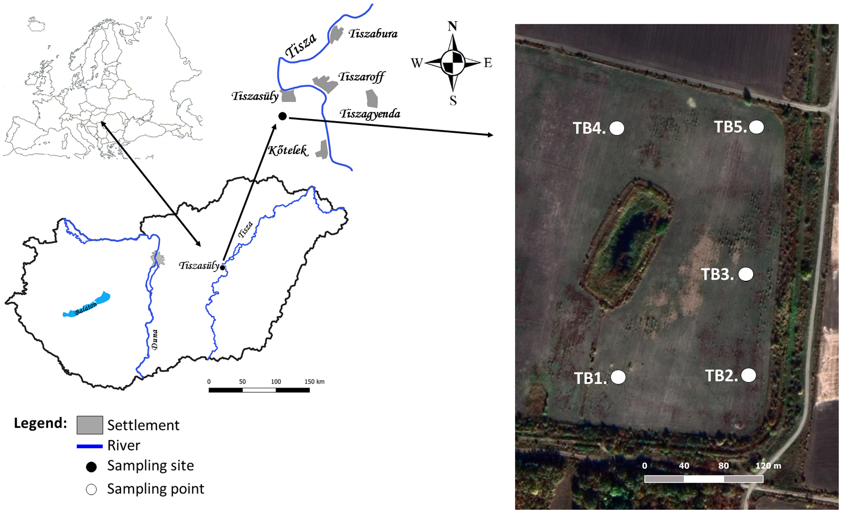
Five shallow boreholes (avg. depth 19–20 m), were drilled for industrial purposes in the Jászság Basin 2.5–3 km (in 2016) away from the main channel of the river Tisza (near Tiszasüly) (Figure 2). The core (core diameter 70 mm and double tube core barrel 101 mm diameter casing) was obtained using a B1A type Wirth drilling rig.
Location of the sampling site in the Carpathian Basin.
The selection of samples from each stratum in our study was driven by our wish to check the validity of the assumption of previous scholars (Kuti and Kőrössy Reference Kuti and Kőrössy1989; Rónai Reference Rónai1985), according to which the entire stratum (∼20 m) was supposedly accumulated in the course of the Holocene, over the past 11,200 years. We wanted to examine this presumption by an improved measuring technique. In cases where there was a sharp lithological change in the sections, which was probably related to major developmental and/or climatic events and changes, we also collected OSL samples in parallel with 14C sampling. Thus, an independent method was used to check the chronology of events. 14C and OSL results of 5 parallel, neighbouring cores were compared for a flood plain area to provide independent estimates of the sediment age. In this way, we examine the effect of the physical placement of the boreholes on the different age results, as well. We aimed to compare data from the five parallel boreholes, including the stratigraphy and to scrutinize the lithological changes in the stratigraphy for possible traces of eventual significant past environmental or climatic shifts related to the lithohorizons.
3.1. Description of the cores and sampling
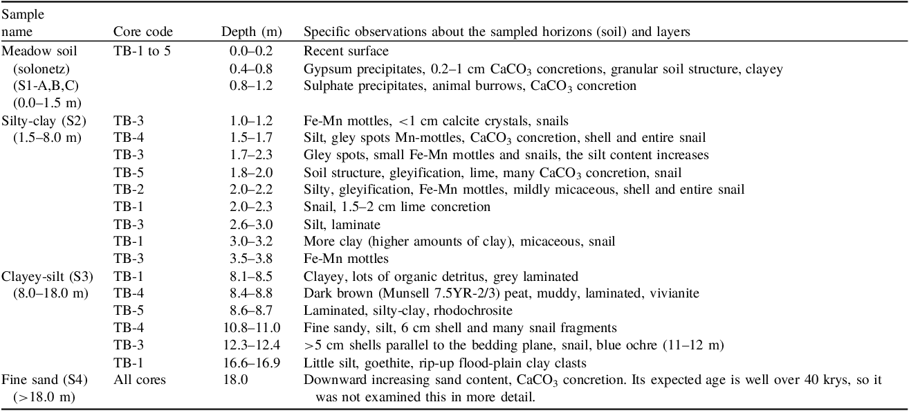
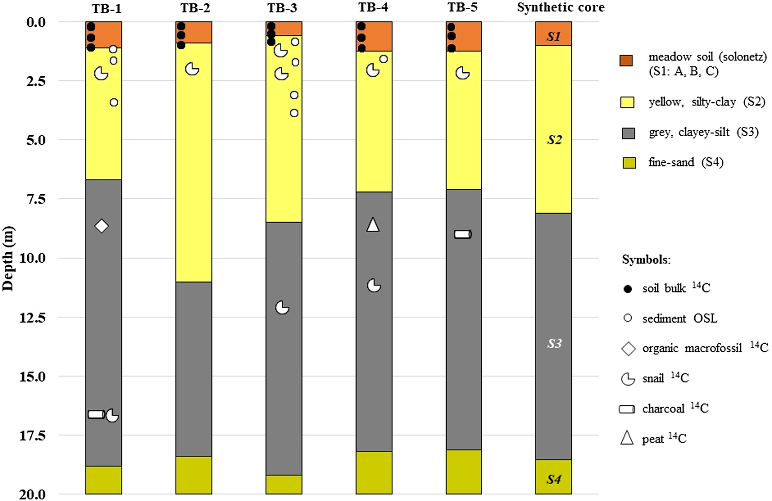
The description and measurement type of the investigated beds of the 5 parallel cores (TB-1 to TB-5, taken as representative of the Tiszasüly borehole cores) is summarized in Table 1. The material from the drill-cores was subdivided into 4 major sedimentary layers (S1 to S4), according to lithostratigraphic observations, namely meadow soil on the top (S1-A, B, C); silty-clay (S2) below; a clayey-silt (S3) section further below; and finally, a fine-sand (S4) at the bottom of the hole (Figure 3). The fine-sand (S4) layer is obviously older age than 40 kyrs, thus it is out of the scope of our study, therefore we did not examine it any further.
Specific observations about the layers from which 14C/OSL samples were collected
Correlated drilling profiles with sampling points (synthetic core: Compiled for the integrated interpretation of all the measured ages and for a common age-depth model. The boundaries of the individual layers were calculated as the mean of the actual depth of the particular layer(s) in each investigated (TB-1 to TB-5) core. S1-A, B, C: The three levels of the meadow soil horizons (recent top; middle level; sub-level). S2; S3; S4: Levels below the meadow soil layer (silty-clay; clayey-silt; and boundary between the clayey-silt and sandy layer).
On the top of the sequences (S1, Solonetz meadow soil), the dark brownish gray (Munsell 2.5Y-3/3) blocky structured humic layer of about 1–1.5 m thickness belongs to the current alkaline soil (Figure 3). Comparative bulk 14C samples were taken from the upper meadow soil layer (S1) of the 5 parallel drills, preferably from soil depth horizons of the same depth. We separated the top soil horizon (recent top meadow soil, S1-A), the middle level (S1-B) and finally the bottom meadow soil (sub-level, S1-C) in the sequence.
Below that, the underlying layer (S2) is a 5–8 m thick yellow gray (Munsell 10YR-6/6) gleyic, mottled, silty-clay formation with Fe concretions and rhizoconcretions. It is a carbonate-sulphate-pedocal-solonetz type soil-sedimentary complex. Its unusual thickness is apparently due to the aggradation of the flood plain. The redox-mottling refers to a past and also present position close to the level of the groundwater-table and is very characteristic of the flood plain environment. During the drilling operations, the actual groundwater-table was around 2 m below the surface. It oscillated with the water level of the river Tisza. The formation displays a non-stationary, at most intermittent hydromorphy.
From the upper level of the silty-clay (S2), below the uppermost meadow soil, close to the boundary between the meadow soil and the silty layer (mean depth: 1.02 ± 0.2 m), there was a large amount of snail shells, CaCO3 concretions (see Table 1) in almost every borehole, so it seemed appropriate to take 14C samples also here.
Samples from the lithologically distinct levels exhibit significant geochemical characteristics, as the silty-clay (S2) has a weak alkalinity, an organic content of 1.5–1.8%, and a low to medium degree of polymerization of the organics. An exception is the organic matter content of the TB-4 borehole sample taken from the peat layer at 8.5 m (S3 clayey-silt layer), which is extremely rich in organic matter (reaching 10.2%) and is also slightly alkaline. This layer reflects a climatic period that may have resulted in a wetter, more restricted anaerobic environment that favoured the formation of peat. To investigate this more closely, radiocarbon samples were also analysed here. In most cases, the same type of macrofossils was extracted from the same relative depth intervals, making the correlation between parallel cores even more accurate.
The transition from S2 to S3 layers starts from the yellow blocky-structured part (S2), which is significantly different from the underlying dark-gray, laminated part (S3). This visible difference is likely due to a change of the drainage/deposition conditions in the past.
The underlying layer (S3), which is the thickest (9–10 m) part of the sequence, is a dark-gray (Munsell 5GY-4/1, 5Y 4/1, N3) laminated micaceous clayey-silt. While it is structurally sharply separated, its color shows gradual transition from the overlying formation. At the bottom, the appearance of 10–20 cm sand intercalations becomes more frequent. The sediment suggests accumulation under stagnant water conditions, which was probably the result of the filling of an abandoned meander. At the bottom of this section, fine-grained sand was found, likely deposited by the “Paleo-Bodrog” (Cserkész-Nagy Reference Cserkész-Nagy2013; Gábris Reference Gy, Mészáros, Schweitzer and Tóth2002; Nagy et al. Reference Nagy, Vajk, Tóth and Sztanó2005, Reference Nagy, Tóth and Sztanó2007). The lowest section of S3 was either a swamp represented by a thin layer of peat, or it was an aggradating flood plain. At the deepest point of this section, the peat layer described reflects a swamp-like environment. A dark gray, laminated loamy layer forms the lower part of the sediment here. It is stained with organic matter suggesting, oxygen poor and reducing depositonal environment, resulted by organic decay. These reducing conditions are well-illustrated also by the presence of vivianite and rhodochrosite.
A thick gray fine sand (Munsell 10GY-4/1) layer (S4) appears at the very bottom of all the boreholes (> 18.5 m). It is a clayey, in some parts micaceous, silt and at the depth of 19 m shows a large CaCO3-concretion and one limonitic nodule. The originally laminated sedimentary structure is difficult to observe here and the sand content strongly increases downwards. This section is obviously older than 40 kyrs, so we did not examine this section further.
A “synthetic” core sequence was constructed to gain a synthetic model of the cores, which was applied for the integrated interpretation of all the measured ages and for a common age-depth model (see Figures 4–6). In the synthetic sequence, the boundaries of the individual layers were calculated as the mean of the actual depth of the particular layer(s) in each investigated (TB-1 to TB-5) cores (Figure 3, Table 2).
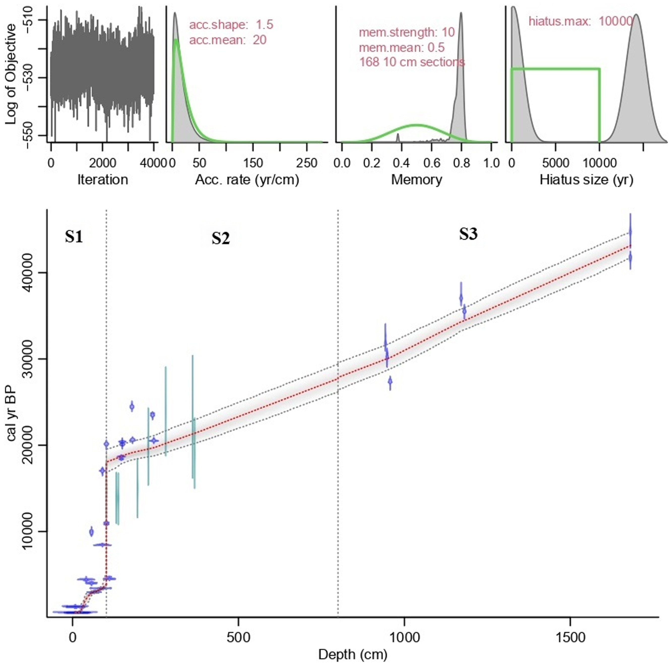
Age-depth model of the whole section of the synthetic core (S1 to S3 layers). The blue symbols are the 14C results and the light green symbols are the OSL results. The vertical dashed lines mark the boundaries of each layer in the model.
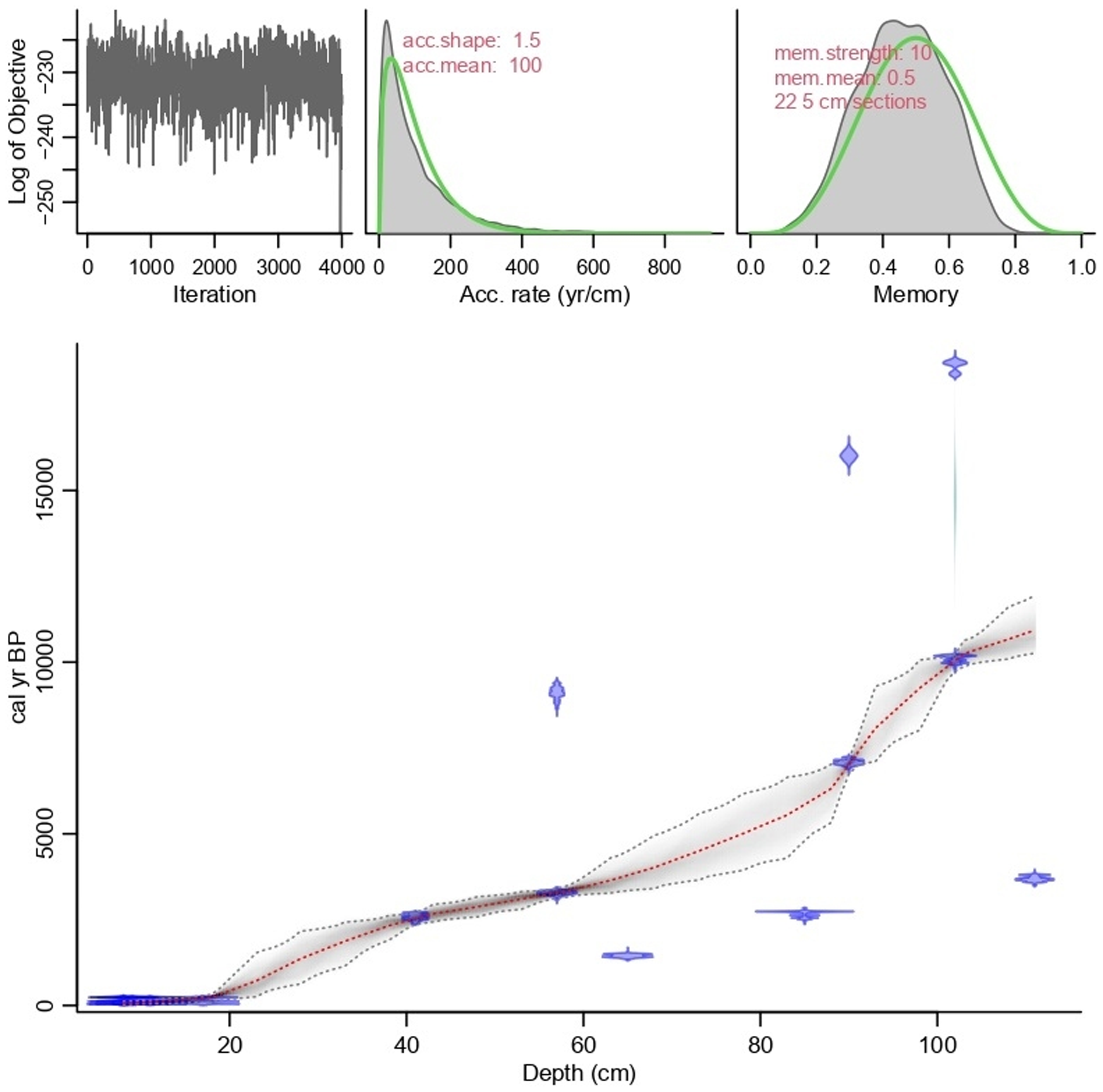
Age-depth model of the Holocene section (S1: A, B, C) of the synthetic core (blue symbols: 14C results; light green symbols: OSL results).
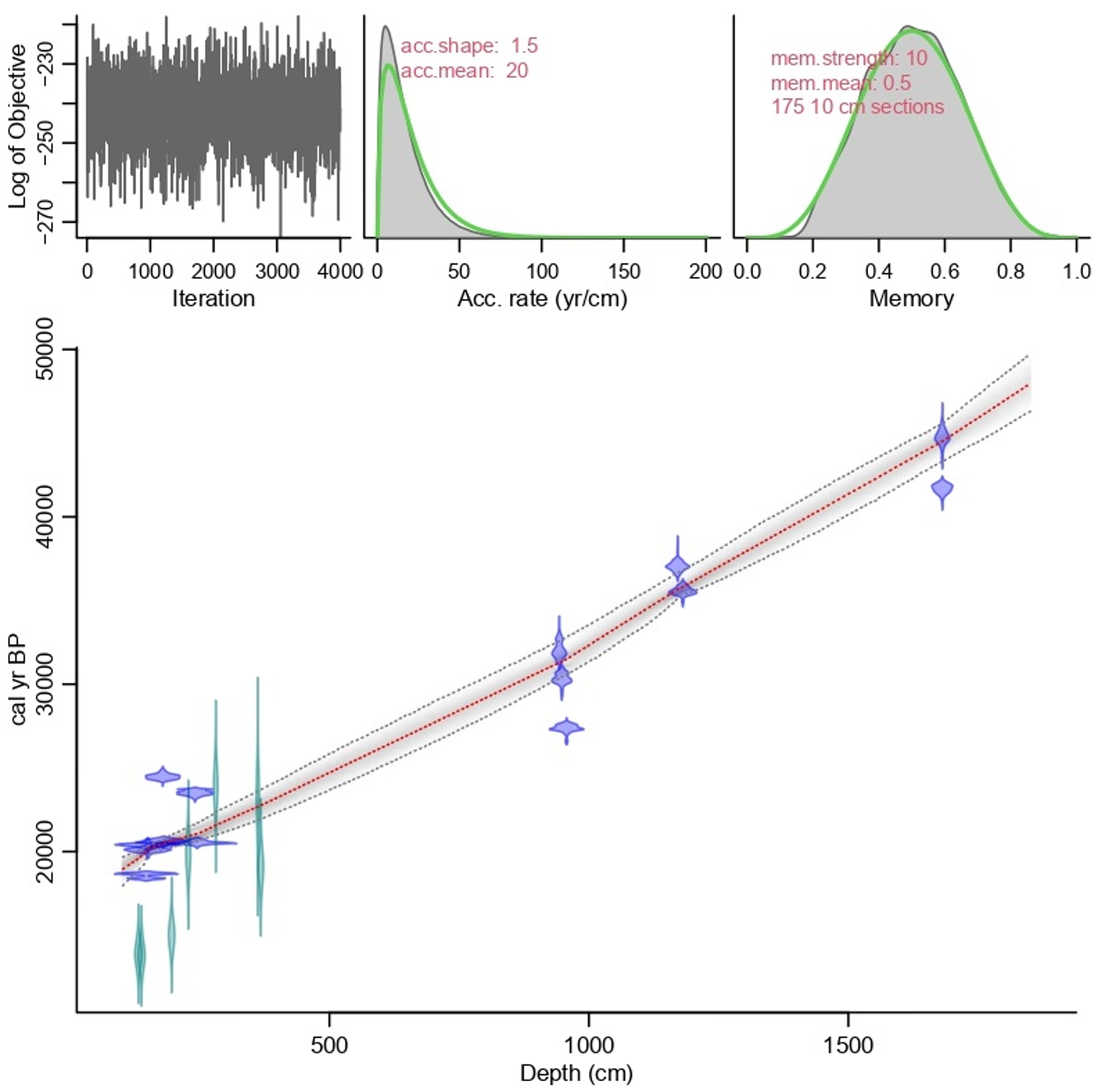
Age-depth model of the Last Glacial; Upper Pleniglacial and Middle Pleniglacial section (S2-S3 layer). (blue symbols: 14C results; light green symbols: OSL results).
Summary of radiocarbon and OSL ages of gastropod, bivalve, charcoal, bulk SOC soil and sediment
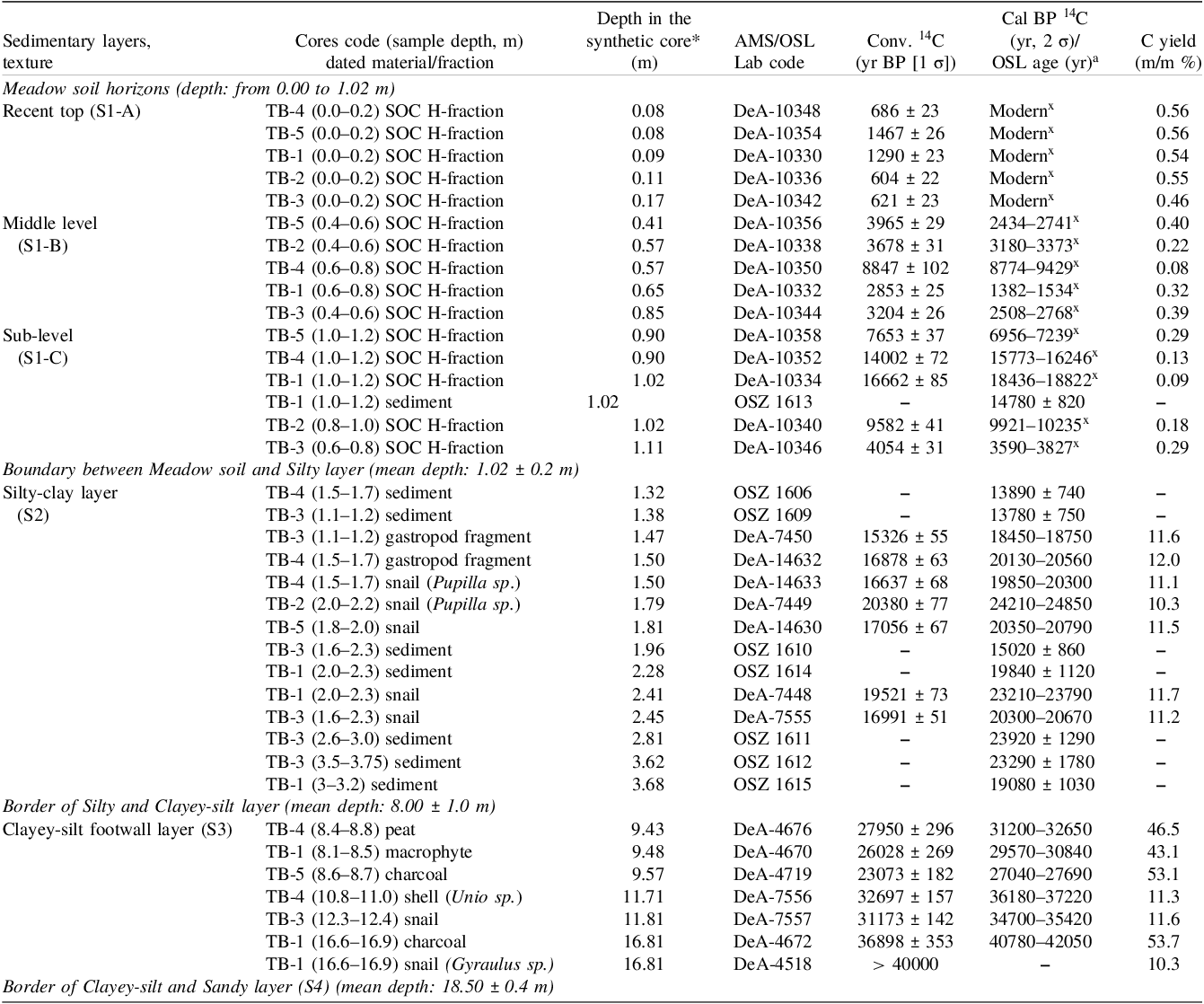
* Relative position in the synthetic sequence/core (m): it corresponds to the relative depth of the sample in its actual lithostratigraphic layer in the actual core (actual depth of the sample in the layer divided by total thickness of the actual lithostratigraphic layer). Order of samples is defined by the relative position of the sample in the actual lithostratigraphic layer (TB-1 to TB-5). The “H-high” fraction means charred C fraction of the soil, combusted and extracted at 800°C.
a The radiocarbon ages are calibrated using the IntCal20 calibration (Reimer et al. Reference Reimer, Bard, Austin, Bayliss, Blackwell, Bronk Ramsey, Butzin, Cheng, Edwards, Friedrich, Grootes, Guilderson, Hajdas, Heaton, Hogg, Hughen, Kromer, Manning, Muscheler, Palmer, Pearson, van der Plicht, Reimer, Richards, Scott, Southon, Turney, Wacker, Adolphi, Büntgen, Capano, Fahrni, Fogtmann-Schulz, Friedrich, Köhler, Kudsk, Miyake, Olsen, Reinig, Sakamoto, Sookdeo and Talamo2020) and the OSL ages are the ages as explained in the text.
X The present surface (recent top meadow soil) represents the present-day (zero age) soil. The mean conventional apparent radiocarbon age of SOC H-fraction of the recent surface samples (940 ± 420 years, n = 5) was used to compensate the radiocarbon reservoir effect before calendar age calibration in case of deeper/older soil horizons.
3.2 Radiocarbon and OSL sample selection
In all cases, we separated macrofossil materials for radiocarbon dating from the floodplain sediments (altogether 9 gastropods, 1 bivalve, 1 sample of peat, 1 macrophyte, and two pieces of charcoal). For later comparison of the results, the samples were selected specifically from stratigraphically-correlated layers. In most cases, the same type of residuals were extracted from the same relative depth intervals from each core, to help more accurate correlation between the parallel cores. Additional sampling points were needed to identify the age of the sharp lithological change between the silty-clay and clayey-silt layers. With this in mind, 14C samples were taken from above and below this boundary, and also from the lowest sandy section.
Determining the organic matter (SOM: soil organic matter) content, the Walkley-Black method was used (Stefanovits et al. Reference Stefanovits, Gy and Gy1999; Van Reeuwijk Reference Van Reeuwijk1995) of the samples. The color of the sediment samples was described according to the Munsell Soil Color Chart (Munsell 1990). Well-separated boundaries in the sequences below the ground-water level were also sampled. The Solonetz-meadowy type topsoil was sampled at three levels (at the recent surface; at middle level; and at the contact with the yellow-colored silty-clay) down to the ground-water level (1.5-to-2-m depth) with a 10 cm general screw auger. Sediment samples were taken at every 20 cm for radiocarbon dating from soil organic matter. Also, OSL sampling was undertaken, but at slightly greater depth intervals (3–3.5 m) (see Figure 3. for locations of radiocarbon and OSL samples). OSL sampling by using hand drills was performed later than the main drilling campaign, which is why it was not possible to sample the underlying sandy deposits for optical dating.
3.3 OSL analyses
Optically stimulated luminescence (OSL) is a trapped-charge dating method, which can be applied to determine the age of sedimentation, i.e. the last time when the quartz or feldspar grains of the investigated sample were exposed to a sufficient amount of sunlight. However, in fluvial deposits, exposure time may not be long enough to reset or bleach the traps responsible for charge accumulation (known as partial bleaching), which in turn can lead to age overestimation (Rittenour Reference Rittenour2008; Tóth et al. Reference Tóth, Gy, Kiss and Bartyik2017). The problem is especially significant for fine grained silty deposits. As earlier research near the Lower Tisza River has shown, the mean age-overestimation in case of fine-grained sediments can be ∼1.5 kyrs in comparison to more reliable coarse-grain derived ages (Sipos et al. Reference Sipos, Kiss and Tóth2016). In this study we had opportunity to compare the obtained OSL data to overlying 14C sample ages, which helped to create a more realistic combined method age-depth model. Unfortunately, in the case of these samples, there was no chance to separate coarse grains, thus we were not able to perform coarse-grain or comparative measurements using OSL.
The preparation of samples followed usual laboratory techniques (Mauz et al. Reference Mauz, Bode, Mainz, Blanchard, Hilger, Dikau and Zöller2002). All procedures were carried out in subdued yellow light provided by low pressure Na-lamps. Water content was determined using the formula of (mw-md)/md, where mw and md are wet and dry weight of the sample, respectively. We applied in situ water contents during the calculations and a ±5% error, which is sufficient in this floodplain environment with an almost continuous groundwater supply.
We attempted to separate grains as coarse as possible, but as the sampled sediments were silty deposits, the fine grain technique was applied, using the 11–20 µm fractions, or 4–11 µm in the case of two samples (OSZ1415, OSZ1416) which were separated by settling. Carbonates and organic material were removed by repeated treatment in 10% HCl and 10% H2O2. The abundance of quartz in the samples was enhanced by a 7-day etching in H2SiF6. Several aliquots of the same OSL samples were prepared by pipetting 2 mg of sample in suspension on aluminium discs.
OSL ages are calculated from the ratio of 1) the absorbed total dose (palaeodose or its laboratory equivalent), recorded by the amount of trapped charge, and 2) dose rate, the annual amount of radioactive dose to the mineral grains. OSL measurements themselves aim to determine the amount of absorbed dose by generating a function between laboratory doses and subsequent luminescence responses (dose response curve) (Figure S1). To determine the value of the absorbed total dose (De: equivalent dose) a RISØ DA-20 TL/OSL type luminescence reader was used (Bøtter-Jensen et al. Reference Bøtter-Jensen, Thomsen and Jain2010) and the single-aliquot regeneration (SAR) protocol was applied (Murray and Wintle Reference Murray and Wintle2003). Stimulation was carried out using blue (470 nm) LEDs, while detection was made through a U-340 filter. The suitability of the samples for dating was tested by comparing decay curves to that of the RISØ calibration quartz (Figure S1) and by performing dose recovery tests at different preheat temperatures (Figure S2). Although signal intensity was lower in case of the Tiszasüly samples, the decay curves fitted well to the standard, referring to adequate signal composition (Figure S1). Based on the dose recovery tests, the mean ratio of given and measured doses was close to unity (1.02±0.01), while recycling ratios and recuperation values were also within the acceptable range (Figure S2). The IR/OSL ratio inserted at the end of the measurements showed that none of the samples contained any feldspar contamination.
Finally, SAR measurements were performed using 200°C/160°C preheat/cutheat treatment on 12 aliquots per sample. Dose points were fitted with a single-saturating exponential function. Standard rejection criteria (Murray and Wintle Reference Murray and Wintle2000; Duller Reference Duller2003) were used to select aliquots for further calculations (recycling ratio: 1.00±0.10; maximum dose error: 10%; maximum recuperation: 5%, maximum IR/OSL depletion ratio: 5%). Sample De was given as the mean and standard error of single-aliquot De values. Values were plotted on abanico plots (Dietze et al. Reference Dietze, Kreutzer, Burow, Fuchs, Fischer and Schmidt2016) (Figure S3) generated in the R luminescence package (Kreutzer et al. Reference Kreutzer, Schmidt, Fuchs, Dietze, Fischer and Fuchs2012).
Environmental dose rate (D*) was determined by using high-resolution, extended range gamma spectrometry (Canberra XtRa Coaxial Ge detector), using 500 cm3 marinelli beakers. Dry dose rates were calculated using the conversion factors of Adamiec and Aitken (Reference Adamiec and Aitken1998). Effective α dose rate was calculated by using a 0.04±0.02 a-value (Mauz et al. Reference Mauz, Packman and Lang2006). Attenuation factors for α and β dose rates were given after Brennan et al. (Reference Brennan, Lyons and Phillips1991) and Brennan (Reference Brennan2003), respectively. Wet dose rates were assessed on the basis of in situ water contents (Aitken Reference Aitken1985). The rate of cosmic radiation was based on burial depth following the equation of Prescott and Hutton (Reference Prescott and Hutton1994). The OSL ages have a relative error of 5–6%, which is reasonable in terms of fine grains ages, which provide an even distribution of equivalent doses.
3.4 Radiocarbon sample preparation and measurements
Most organic samples, for example plant fragments, charcoal and peat, were treated using the standard acid-base-acid (ABA) method, following standard protocols (Jull et al. Reference Jull, Burr, Beck, Hodgins, Biddulph, Gann, Hatheway, Lange and Lifton2006). The samples were treated with a sequence of 1N HCl, deionized (18 MΩ pure) water, 1M NaOH, deionized water, and then 1N HCl. For bulk soil and sediment samples, only the acid treatment was used. After the final acid wash, bulk samples were washed again with deionized water to slightly acidic pH (5–6) and then dried. Sample were then ready for two-stage combustion in oxygen and a final combustion with MnO2.
For combustion and CO2 purification, the Hertelendi Laboratory of Environmental Studies (HEKAL) AMS laboratory uses an in-line combustion and CO2 purification line built in-house and based on system at the University of Arizona (Jull et al. Reference Jull, Burr, Beck, Hodgins, Biddulph, Gann, Hatheway, Lange and Lifton2006; Molnár et al. Reference Molnár, Janovics, Major, Orsovszki, Gönczi, Veres, Leonard, Castle, Lange, Wacker, Hajdas and Jull2013a). Two-stage heating with controlled temperatures (400°C, “L-low” and 800°C, “H-high” fraction) is required to perform precise temperature-stabilized gradual fractional oxidation. Samples are combusted in the presence of 5.0 quality oxygen gas (Linde Hungary Ltd.). The carbon dioxide is cryogenically separated from water at –78°C using a mixture of isopropyl alcohol and dry ice, passed over Cu/Ag to reduce nitrogen oxides and remove halogens, and trapped in a known volume at liquid nitrogen temperature. The gas pressure is measured in a known volume, to calculate the yield. The combustion of the samples takes place in quartz tubes. On average, ∼10 mg of a charcoal sample and ∼1 g of soil or sediment were combusted. Then, the purified CO2 gas sample is transferred to a sealed tube for graphitization. In the case of snails and shells, the samples were placed in a two-finger flask with a special valve. Samples were placed in the standing finger and the phosphoric acid in the other. After evacuating the flask, the acid (85% H3PO4 aq) is poured onto the sample in the other finger. The CO2 produced from the carbonate in the sample is then introduced into our on-line combustion/CO2 purification system (Molnár et al. Reference Molnár, Janovics, Major, Orsovszki, Gönczi, Veres, Leonard, Castle, Lange, Wacker, Hajdas and Jull2013a).
The last step of the sample preparation in most cases is the graphite production from the CO2 gas samples. Graphite targets were prepared by a sealed tube graphitization method at HEKAL (Rinyu et al. Reference Rinyu, Orsovszki, Futó, Veres and Molnár2015). After transfer of the CO2 gas and sealing of the reaction tubes, the graphitization process consists of 2 steps: 1) 3 hr at 500°C to release the hydrogen and reduce the iron powder, and 2) 5 hr at 550°C regular graphitization process.
All of the 14C measurements reported below were performed by our EnvironMICADAS AMS (Molnár et al. Reference Molnár, Rinyu, Janovics and Major2013b). Measurement time and conditions were set to collect at least 200,000 net counts for every single target in case of a modern sample. The overall measurement uncertainty for a modern sample is <3‰, including normalization, background subtraction, and counting statistics. For testing organic sample preparation procedures, the laboratory used international 14C reference materials with known 14C activity (IAEA-C9 [wood]), and carbonate samples IAEA-C1 (marble) and IAEA-C2 (travertine).
Furthermore, we can simultaneously measure the 13C/12C ratio of the sample, which is essential for the correction of the radiocarbon age. The maximum age of 14C measured with this instrument is 50,000 years and the average measuring time of each sample is approximately half an hour (Molnár et al. Reference Molnár, Rinyu, Janovics and Major2013b). The blank level for each type of samples in case of 1 mg C carbon content is very reproducible around 0.3–0.5 pMC. The results are quoted as conventional radiocarbon ages in years BP (Table 2).
3.5. Age-depth model construction
To explore the history of the past 40,000 years for this research area, we have summarized the 14C and OSL data into an integrated age model, also taking into account the different bed thicknesses in each borehole. In the following, we present the age-depth model of the integrated “synthetic” cores using the BACON software package (Blaauw and Christen Reference Blaauw and Christen2011). We have interpreted the information provided by each sample as a function of the environmental and climatic conditions that—according to the literature—may have been associated with that period. In the integrated age-depth model, the apparent age-corrected and calibrated 14C and OSL ages were used together as two independent age indicators. Although the radiocarbon method is more applicable to short-lived organic matter (wood, charcoal, plant residues, gastropods, bivalve) than dating bulk soil, we have obtained a consistent depth model for the three genetic levels.
The 14C and OSL data from the 5 boreholes were transferred into a uniform age model, taking into account the different layer thicknesses per borehole. Age-depth modelling calculation was obtained using Bayesian age modelling software BACON (Blaauw and Christen Reference Blaauw and Christen2011) version 3.2 with the IntCal20 calibration curve (Reimer et al. Reference Reimer, Bard, Austin, Bayliss, Blackwell, Bronk Ramsey, Butzin, Cheng, Edwards, Friedrich, Grootes, Guilderson, Hajdas, Heaton, Hogg, Hughen, Kromer, Manning, Muscheler, Palmer, Pearson, van der Plicht, Reimer, Richards, Scott, Southon, Turney, Wacker, Adolphi, Büntgen, Capano, Fahrni, Fogtmann-Schulz, Friedrich, Köhler, Kudsk, Miyake, Olsen, Reinig, Sakamoto, Sookdeo and Talamo2020). The age-depth model was separated into three sections (S1-S2-S3) based on specific periods (see Figures 4–6 and Section 4).
4. Results and Discussion
4.1 Results of radiocarbon and OSL analyses
In Table 2. conventional and calibrated radiocarbon ages (yr BP/cal BP) and OSL (yr before 2019) data with the material types (SOC, sediment, snail, gastropod, macrophyte, peat, charcoal) and depths. In total, 29 14C ages and 8 OSL ages were obtained from the 5 investigated cores.
Although the OSL signal of the Tisza flood plain samples was weaker than for the calibration quartz standard, their decay curves are similarly shaped and indicate that the OSL signal is dominated by the fast component. Based on the dose recovery tests, the mean ratio of measured and regenerated doses was close to unity (1.02 ± 0.01), while recycling ratios and recuperation values were also within the acceptable range.
Some of the intact snail samples revealed in parallel drill cores have also been identified by species, namely Pupilla sp. (terrestrial gastropod) (TB-2 [2 m] and TB-4 [1.5–1.7 m]) these were in layer S2; while Gyraulus sp. (aquatic gastropod) (TB-1 [16.6–16.9 m]) and a Unio bivalve (TB-4 [11 m]) in layer S3. Macrophytes and charcoal remains were also recovered from the S3 layers at 8.1–8.5 m (TB-1), 8.6–8.7 m (TB-5). From the sedimentological point of view, the yellow, silty-clay layer (a carbonate-sulphate complex) indicates that the area has started to become land-based at this time. Occasionally, during small floods, the sediment-surface must have been inundated or at least partially saturated with water, as evidenced by the appearance of redox spots (Fe-Mn mottles). However, Pupilla sp. was found at 2 m depth (DeA-7449, 20380 ± 77 BP, 24215–24850 cal BP), falling into the Last Interstadial which was a warmer climate period and preceded the Last Glacial Maximum (iSBLGM, 23000–25000 kyrs [after Gábris Reference Gábris2003]). Unio sp. (DeA-7556, 32697 ± 157, 36180–37220 cal BP) and Gyraulus sp. (DeA-4818, > 40000 BP) were found much deeper in the TB-1 borehole profile. The habitat of both species is aquatic, which is supported also by the type of the sediment, indicating an environment fostering the accumulation of gray clayey-silt (S3). In terms of climate, these sediments must have been deposited at the time of the Denekamp (34–36 kyrs) and Hengelo (38–40 kyrs) interstadials (after Gábris Reference Gábris2003).
In all cases, the 14C measurements of the snail shells collected from the 5 boreholes in this area gave increasing “snail ages” that were consistent with the nature of the sediment and the former depositional environment. Overall, there was no significant “limestone effect,” charcoal and snail samples (TB-1 16.6–16.9 m) from nearly the same depth intervals gave similar results.
In earlier examples in the literature, the so-called limestone or “hard-water”-effect should be considered in the radiocarbon data of snails (Újvári et al. Reference Újvári, Molnár, Novothny, Páll-Gergely, Kovács and Várhegyi2014). Snails may, namely, carry older “fossil,” limestone-sourced CaCO3 and incorporate it into their skeleton, thus modifying their real age. Previous studies have documented that land snail shells yield anomalously old radiocarbon ages reaching as much as 3000 yrs offset due to incorporation of old, 14C-free carbonate from the local substrate into shell carbonate. This phenomenon is often referred to as the “limestone problem” (Evin et al. Reference Evin, Marechal, Pachiaudi and Puissegur1980; Goodfriend Reference Goodfriend1987; Goodfriend and Hood Reference Goodfriend and Hood1983; Goodfriend and Stipp Reference Goodfriend and Stipp1983; Rubin et al. Reference Rubin, Likins and Berry1963; Tamers Reference Tamers1970; Xu et al. Reference Xu, Gu, Han, Hao, Lu, Wang, Wu and Peng2011; Yates Reference Yates1986; Zhou et al. Reference Zhou, Head, Wang, Donahue and Jull1999).
4.2 Age-depth model and associated climatological aspects
Out of the 5 parallel drill cores, a total of 37 age results were obtained, 29 14C (blue symbols) and 8 OSL (light green symbols) results were included in the model (Figure 4). The model also attempted to estimate the history of accumulation of the sedimentary sequence over time (Table 3).
Summary table of age interval and app. accumulation rate of the different layers of the “synthetic core”

* abs. distance from the top recent surface (m), aAR: apparent accumulation rate. LGP: Last Glacial period, UPG: Upper Pleniglacial, MPG: Middle Pleniglacial
The obtained radiocarbon age data (cal BP 2σ) were fit into the local age-climate subdivision of the Late Pleistocene–Holocene published by Gábris (Reference Gábris2003) and Gábris and Nádor (Reference Gábris and Nádor2007); modified by Cserkész-Nagy. (Reference Cserkész-Nagy2013) after Sümegi and Krolopp (Reference Sümegi and Krolopp2002). We interpreted the results of the studied sequences in this framework (Figure 4).
Given known Late Quaternary climatic fluctuations, it was expected that the traces of extreme climatic conditions would also appear in the strata of the research area, and that traces of these temporary variations would be preserved in the layers.
We assumed that a hiatus might occur at the borders between S1-S2 or S2-S3 layers. As it is presented in (Figure 4) a significant hiatus was detected, indeed, between layers S1-S2. The detailed description of the time interval of this break at the border of S1-S2 in the age-depth model is discussed below.
4.2.1 Recent top meadow soil (S1: A, B, C)—the Holocene
According to our age-depth model, the formation-times of the meadow soil samples taken from 3 levels (top-middle-bottom) all fall into the Holocene (Figure 5).
These samples represent the upper 0–1.1 m layer of the five drill cores tested. The soil organic matter (SOC H-fraction) of the present surface (recent top meadow soil) of each individual core was dated by 14C and their conventional apparent radiocarbon age was used for reservoir correction on the core. The mean apparent age of the five cores was 940 ± 420 years (n = 5), which is in good agreement with earlier soil apparent age observations from the Carpathian Basin (Buró et al. Reference Buró, Lóki, Győri, Nagy, Molnár and Négyesi2019; Molnár and Svingor Reference Molnár and Svingor2011; Novák et al. Reference Novák, Molnár and Buró2018; Tóth et al. Reference Tóth2018). The apparent radiocarbon age of the core was used to correct the radiocarbon reservoir effect on the deeper buried soil layers measured by the same method on the SOC H-fraction. The reservoir-corrected soil organic matter ages were used in the BACON model to calculate the synthetic age-depth sequence (Figure 5).
We have applied the “apparent age” correction only to samples that are mostly Holocene. One has to be very careful on the impact of using a correction of “recent soil mean apparent 14C age” to define the age of older soils or older horizons. It could be an extra error generated by not taking into account the evolution of atmospheric 14C history, and give significant contribution for the associated error (100–150 14C years) if not exactly calculated. As dynamics of upper horizons is not the dynamics of lower horizons.
This consolidated Holocene section (S1) is about 1.0–1.1 m thick and shows ∼100 yr/cm apparent mean accumulation rate, based on five investigated sequences (Table 3). According to the model the S1 layer began 10.0 kyr ago, although we have observed some few thousand years older ages, too, (both 14C and OSL) in some individual cores (SOC H-fraction 14C: TB-4 [1.0–1.2] and TB-1 [1.0–1.2], sediment OSL: TB-1 [1.0–1.2]).
There are 16 age data available to describe the 1 m thick section, which comes from 5 different boreholes and of course, due to the uncertainty arising from the methodological limitations of age determination and the model, we obtained an imperfectly consistent age model. It seems obvious that this layer covers the entire Holocene from 10 kyrs cal BP to present.
At the bottom of the S1 close to the S2 layer, gypsum and sulphate precipitation, as well as CaCO3 concretions appear in the meadow soil, which typically occur in arid/semi-arid climate conditions.
4.2.2 Silty-clay layer (S2)–Last Glacial to Upper Pleniglacial
Looking at the boundary between the Meadow soil (S1) and Silty-clay layer (S2) (mean depth: 1.02 ± 0.2 m) in some individual cores (TB-2 and TB-3), the 14C age of the neighbouring layers have significant age steps in a relatively short depth distance. The apparent mean accumulation rate jumps from 20 yr/cm to 100 yr/cm at the border (Table 3).
According to the BACON age-depth model, it is likely that significant amounts of the sediment are missing at the boundary between S1 and S2 namely from the period between 10 to 19 kyrs cal BP. This means that the upper part of layer S2 finished at 19 kyrs cal BP while S1 layer starts only at 10 kyrs cal BP.
In the literature there are very similar hiatuses at this age range (between 10 and 24 kyrs cal BP) just below the recent top soil layer at the Dunaszekcső loess sequence and also at the Süttő loess sequence (Novothny et al. Reference Novothny, Frechen, Horváth, Wacha and Rolf2011; Újvári et al. Reference Újvári, Molnár and Páll-Gergely2016). At Dunaszekcső, the recent top soil is 2.3 m thick and the loess layer ends at this 2.3 m depth while its age at the top is about ∼24 kyrs. It means there is a hiatus between 12 and 24 kyrs in the sequence at the Dunaszekcső. At Süttő, we have constructed a BACON age-depth model for the top loess layer (depth 0.66–6.00 m), using the reported OSL ages from Novothny et al. (Reference Novothny, Frechen, Horváth, Wacha and Rolf2011). The model output shows the top part of the loess layer was formed about ∼24.3 kyrs ago (Figure S4). There is only a relatively thin top recent soil above this loess sequence (66 cm thick), which is formed very likely during the Holocene. Thus, also for the Süttő loess sequence there is a hiatus for the age period between 12 and 24 kyrs cal BP.
According to the regional climatic- and environmental change characteristics (environment and climate construction) established by Gábris and Nádor (Reference Gábris and Nádor2007), Gábris and Nagy (Reference Gábris and Nagy2005), Gábris et al. (Reference Gábris, Horváth, Novothny and Zs2012), and Kasse et al. (Reference Kasse, Bohncke, Vandenberghe and Gy2010) for the Upper Pleistocene and Holocene periods, the hiatus encompasses the very beginning of the Holocene and the Late Glacial and Upper Pleniglacial periods. Possible reason for the unconformity might be the wind erosion process as it is usually one of the main drivers of landform formation during cold-dry climatic periods. Wind erosion processes do not favor large-scale sediment accumulation in this region (Cserkész-Nagy Reference Cserkész-Nagy2013). At the beginning of the LGM (Last Glacial Maximum, 23–18 kyrs cal BP ago), the climate showed a tendency to gradually become drier and cooler, which was interrupted by periodic reliefs. The LGM across Europe ended 18–20 kyrs cal BP ago, which was followed by gradually warming periods in which warmer and colder periods alternated. The sedimentary hiatus period includes the Ságvár-Laxcaux interstadial (16.5–19 kyrs), the oldest Dryas (16.5–14.6 kyrs cal BP) and the entire period of the Late Glacial (14.6–11.6 kyrs cal BP), and the accepted beginning of the Holocene (preBoreal period, 11.6–10.2 kyrs cal BP) (Gábris and Nádor Reference Gábris and Nádor2007).
The presence of the hiatus in the studied Tiszasüly sedimentary column between 10 to 19 kyrs cal BP reinforce the hypotheses of Gábris (Reference Gy, Mészáros, Schweitzer and Tóth2002, Reference Gábris2003), according to which during the Older Dryas and Ságvár-Lascaux periods, there was an erosional event (significant meander-cutoff) at the Middle-Tisza region, which can be traced back to some regional climatic influence.
The S2 (depth: 1.0–8.0 m) layer belongs to the Late Glacial and Upper Pleniglacial periods (Figure 6). During these periods (LG/UPG), stadials and interstadials (cold-dry and warm-wet periods) frequently alternated. S2 covers the age range between 19 and 29.2 kyrs cal BP within a 7 m thick layer (depth between 1.02 to 8.0 m).
The S2 layer represents an area of dry land that has become a high flood plain, so continuous fluvial activity probably ceased at this point. From the point of view of sediment stratigraphy, this can be considered an aggrading flood-plain environment, when there were minor and major climate fluctuations during this time. With a sedimentation rate of 20 yrs/cm, it shows a much faster sedimentation than the formation of the S1 Holocene soil layer (100 yrs/cm aAR). But the formation of the S2 layer is twice as slow as the model-calculated value (10 yrs/cm) for the kiln during this period, as well as the accumulation rate of 10 years/cm reported for the loess sequence in Dunaszekcső.
The sediments qualify as a carbonate-sulphate-pedocal-solonetz type soil-sedimentary complex. Its unusual thickness can be explained by the aggradation of the flood plain.
4.2.3 Clayey-silt layer (S3)—Middle Pleniglacial
Based on the age-depth model, the formation of this section falls in the Middle Pleniglacial period. This 18.8 kyrs long period (between 29.2 to 48.0 kyr BP) of sedimentation resulted in deposits with a thickness of 10.5 m (depth between 8.0 to 18.5 m). This part of the section has a very similar accumulation rate as the S2 layer above it (19 yr/cm aAR) (Figure 6, Table 3).
According Gábris and Nagy (Reference Gábris and Nagy2005), at the end of the Middle Pleniglacial (conv. 29–60 14C yrs BP), the warm-humid climate was the most characteristic with one stadial interruption. At that time, fluvial processes dominated the area, which resulted in high rate of sedimentation (Gábris and Nagy Reference Gábris and Nagy2005).
The age-depth model results of S3 layer and its lithological features are in good agreement with the climatic events described above by Gábris and Nagy (Reference Gábris and Nagy2005) mentioned above. The S3 sediment layer has a laminated structure (settling of suspended load) and contains also peat, organic detritus, and a few goethitic spots. It may indicate that this part of the sedimentary sequence was deposited in a stagnant/“dead-” water environment. This layer was most likely formed as the filling material of an abandoned meander (oxbow) of the “Paleo-Bodrog.” The appearance of a peat layer in this section also indicates a stagnant/“dead”-water environment with anaerobic conditions. The presence of the anaerobic environment is also supported by the appearance of vivianite (an iron-phosphate mineral) in this layer.
Sandy intercalations and sand layer (S4) below the S3 layer, begin below 18.5 m depth, and their formation ages are much older than 40 kyr BP. As already mentioned, we did not study this part of the section in detail.
5. Conclusion
The evolution of river channels and flood plains over time has great significance in understanding environmental change. In flood-plain areas, the dynamics of landform formation may be more intense than in other areas.
According to earlier hypotheses, hundreds of meters of Quaternary sediments were deposited by the precursors of the present-day Tisza and Danube Rivers and their tributaries in the Great Hungarian Plain (Hungary). The Tiszasüly research area, together with the whole Carpathian Basin, was part of the periglacial belt during glacial periods of the Pleistocene, so contiguous ice sheets covered the land surface only in the mountainous regions to the North. Rónai (Reference Rónai1985) and Kuti and Kőrössy (Reference Kuti and Kőrössy1989) suggested that the Holocene sedimentation alone might have reached 30–40 m at the top of the sediment column in the Jászság Basin.
Obviously, during the last 40,000 years, sedimentation in this near-floodplain environment has had highly variable dynamics, and some major floods or other erosional effects may even have removed parts of the sequence. In the wider surroundings about 14–18 kyrs ago there might have been several meander-cutoffs until after the Tisza River finally shifted to its present position. The currently available age- and climatic data, suggest that in addition to the Paleo-Tisza and Paleo-Danube, there was also a third river, the “Paleo-Bodrog” of considerable water output, that might have existed in the past in this huge alluvial plain.
14C and OSL results of five parallel, neighbouring cores were examined from a flood plain area (Jászság Basin 2.5–3 km away from the main channel of the river Tisza) in the Tisza River flood plain. Four major sedimentary layers (S1 to S4) were identified in all cores (S1: meadow soil; S2: silty-clay; S3: clayey-silt; S4: sand). The Solonetz-meadow type recent topsoil was sampled in three levels (at the modern surface (S1-A); at middle level (S1-B); and at the contact with the underlying yellow-coloured silty-clay [S1-C]) to gain a more detailed picture about the recent soil formation.
In total 29 14C (altogether 9 gastropods, 1 bivalve or shell-fragments, 1 sample of peat, 1 macrophyte, and 2 pieces of charcoal) ages and 8 OSL (from a depth of 3–3.5 m) ages were obtained from the 5 investigated cores. 14C and OSL data were integrated into a “synthetic” age model using the BACON software package, taking into account also the different thicknesses of the layers encountered in each borehole.
Our results showed that the thickness of the Holocene deposits covering the older Pleistocene layers in the studied area is only 1.5–2 m (the entire S1 recent top meadow soil), instead of the 30–40 m estimated by previous authors (Kuti and Kőrössy Reference Kuti and Kőrössy1989; Rónai Reference Rónai1985) for the Jászság Basin. The apparent mean accumulation shows an approximate rate of 100 yr/cm, based on five investigated sequences. After the S1 horizon, there is a sudden change to apparent accumulation rate (aAR: 20 yr/cm) in the S2 layer, indicating much faster sedimentation.
The silty-clay (S2) layer exhibits the following litologically characteristics, reflecting the variable redox conditions of the floodplain environment: redox spots (Fe-Mn mottle). Some intact snail samples were also found in the sediment, namely Pupilla sp. (terrestrial gastropod) which typically refer to arid conditions. The S2 sediments can be considered as a carbonate-sulphate-pedocal-solonetz type soil sedimentary complex, the unusually large thickness (avg. 7 m) of which can be related to the former aggradation flood plain environment. The formation of the layer falls into the Last Glacial and Upper Pleniglacial climatic period.
Furthermore, the present study also supports the claims of Gábris (Reference Gy, Mészáros, Schweitzer and Tóth2002, Reference Gábris2003), according to which there must have been a major meander-cutoff (erosional event) after the Older Dryas and Ságvár-Lascaux. This event appears also in our BACON depth model (Figure 4) as a sudden slope change (at the boundary between S1-S2). Our age-depth model suggests that sediment is missing from the period between 10 to 19 kyrs BP in the Tiszasüly sediment cores. In the literature, there are very similar hiatuses indicated at this age range (between 10 to 24 kyrs BP) in the Carpathian Basin, at the Dunaszekcső and also at the Süttő loess-paleosol sequence (Novothny et al. Reference Novothny, Frechen, Horváth, Wacha and Rolf2011; Újvári et al. Reference Újvári, Molnár and Páll-Gergely2016) when data are analysed from this point of view. We suggest therefore that this may be the sign of some important regional event.
The S3 (clayey-silt) layer is the thickest in the cores (9 m). It was formed during the Middle Pleniglacial climatic period, and its sedimentation rate is aAR: 19 yr/cm. The S3 deposit is presumed to have formed in a stagnant water environment, as indicated by its laminated structure (suspended load) and the presence of organic macrophytes, charcoal, Gyraulus sp., and Unio bivalve (aquatic gastropod). Presumably, it was formed as the filling material of the former abandoned meander (oxbow) of the “Paleo-Bodrog.”
In addition to the obvious climatic control, the observed stratigraphic changes and the changes of sediment accumulation rate might be influenced also by tectonic movements having affected the Jászság Basin since Miocene times.
Our study delivered some new and important details about the surface evolution of the investigated Tiszasüly area. New aspects of Holocene sedimentation and missing documents of an about 10 kyrs period was revealed using combined dating methods (14C and OSL) on multiple cores.
Supplementary material
To view supplementary material for this article, please visit https://doi.org/10.1017/RDC.2024.140
Acknowledgments
The research was supported by the European Union and the State of Hungary, co-financed by the European Regional Development Fund in the project of GINOP-2.3.2-15-2016-00009 “ICER.” The work was also supported by the Hungarian National Research, Development and Innovation Office under grant No. NKFIH K 119309 and the Bolyai János Research Grant under No. BO/00451/17.


 Open access