In this one-off, extended Project Gallery article, the participants of a recent workshop jointly present a manifesto for the study of ancient Mediterranean maritime connectivity. Reviewing the advantages and perils of network modelling, they advance conceptual and methodological frameworks for the productive study of seaborne connectivity. They show how progressive research methods can overcome some of the problems encountered when working with uneven datasets spanning large geographical regions and long periods of time. The manifesto suggests research directions that could better inform our interpretations of human connections, both within and beyond the Mediterranean.
All references to the authors’ workshop papers in the text denote their oral presentations at the ‘Networks of Maritime Connectivity in the Ancient Mediterranean’ workshop held at the University of Toronto in November 2013.
Background and objectives
We study the ancient Mediterranean, covering four millennia of the human past among us. While some of us work on dry land and others on or underwater, we all use material culture to trace interactions among communities and regions. We are influenced by the work of Reference BraudelBraudel (1972) and that of Horden and Purcell (2000) in viewing interaction—maritime interaction in particular—as a crucial social activity in the formation of communities and cultures. Moreover, following Reference MccormickMcCormick (2001), Reference Van De NoortVan de Noort (2011), Reference BroodbankBroodbank (2013) and others, we recognise that seaborne connectivity engenders particular spatial/geographical, technological and cognitive parameters when addressing environments vitally shaped by marine topography and micro-ecological fragmentation. Although many scholars acknowledge these points, there still exist substantial conceptual and technical barriers to greater exploration of this connectivity and interaction. These barriers range from contemporary political and administrative divisions in the Mediterranean basin, to asymmetrical fieldwork traditions and practices, and to vast quantities of uneven data and narrow research specialisations. Yet progressive research methods can help overcome many of these obstacles. Formal network models provide a common ground for investigating connectivity, straddling different research traditions and specialisations and facilitating analysis of very large datasets of varying degrees of completeness (Reference KnappettKnappett 2013). The recent growth of network analysis in archaeology more broadly shows how a wide range of researchers are tapping into this potential. With careful collaboration across fields among relevant scholars—some more specialised in networks, others in the empirical detail of the ancient Mediterranean—we can generate a new conceptual and methodological framework for the productive study of seaborne connectivity both in and beyond the early Mediterranean. This theatre of research holds great potential for advancing understanding of the origins and growth of connections that have since tied our planet together. This is the primary impetus behind a recent, two-day international workshop held at the University of Toronto on the theme of Mediterranean maritime interaction.
The workshop, ‘Networks of Maritime Connectivity in the Ancient Mediterranean’, sought to interrogate archaeological evidence for particular dynamics of networks within the context of seaborne communication and contact across the prehistoric, ancient and medieval Mediterranean. How did maritime networks emerge and decline? How did human connections shape patterns of seafaring and exchange and vice versa? Can we identify resilience in network shape and behaviour over the long-term—across critical transitions between the Neolithic and Bronze Age, Bronze and Iron Ages, Classical and Hellenistic periods, and the Roman Empire and its successors—despite socioeconomic and functional shifts? To what extent did networks exhibit ‘path dependence’, or is their structure completely fluid and rapidly adaptive to changing conditions and circumstances? This was evidently an ambitious aim and much additional work will be needed; nonetheless, significant progress was made towards general goals. Perhaps more importantly, in pursuing this avenue of research, we encountered a range of methodological problems that require resolution. Our purpose in this manifesto is to highlight some of the more pressing problems and to offer possible avenues for eventual solutions. There is a great deal of potential in network approaches for interrogating, simulating and explaining patterns in Mediterranean history and archaeology. These approaches may also be helpful to researchers studying long-term human contact in other regions characterised by dense maritime interaction, in the Caribbean, the Pacific and the North Sea, for example. In sharing our joint experiences and discussion, we aim here to provoke thought on, to maximise the potential of and to smooth the path towards a more comprehensive and productive study of Mediterranean maritime networks.
Observations and recommendations
Socio-spatial networks
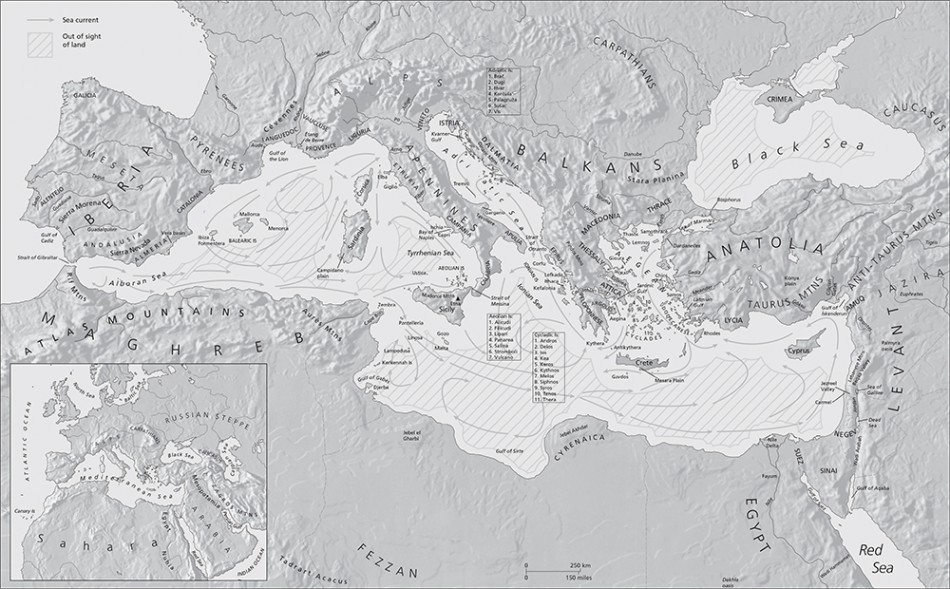
Our first theme concerns the conjoined social and spatial nature of maritime networks. Particular geographical configurations of maritime space clearly have a significant impact on interaction (Figure 1). As underlined by Reference BroodbankBroodbank (2013), the shores of the Mediterranean are quite uneven, particularly between the east and west; the Aegean constitutes roughly one third of the Mediterranean’s entire coastline but only a small percentage of its terrestrial landmass. Most, if not all Mediterranean archaeologists can quite readily grasp this geographical aspect, especially in a region where physical configurations of land and sea are frequently so suggestive. The constraints and opportunities afforded by the sea are well known and archaeologists are prone to representing interactions across the ancient world spatially, especially at the regional or interregional level. Even if we all recognise that our ultimate goal is the explanation of social phenomena in a broad sense, this objective can nonetheless become difficult to attain if always negotiated and visualised purely via spatial distributions. This demands explicit recognition of maritime connectivity as a function of social networks. Perhaps formulating explicitly social questions should necessarily precede examination of spatial networks. Indeed, one of the benefits of network approaches, especially social network analysis, is their capacity to depict ancient networks relationally rather than geographically; the resulting visualisations often prompt new insights. Network analyses are, however, more than methods; there are also theoretical models that can be applied. When we approach significant changes in maritime connectivity over the long term, the explanatory potential of a conjoined socio-spatial perspective becomes even more pertinent.
Map of the Mediterranean Sea showing major maritime topographical features (map courtesy of ML Design & Ben Plumridge © Thames & Hudson Ltd. From The Making of the Middle Sea by Cyprian Broodbank, Thames & Hudson Ltd., London).

Some examples of long-term changes may clarify this point. Broodbank's workshop paper argued that the social function of maritime networks in the Neolithic Aegean was probably primarily demographic (e.g. the need for exogamy in small communities), and also related to the supply of basic raw materials; these remained highly relevant in the Early Bronze Age, when networks seemed to focus more on trade, especially in its more socially inflected forms. With the Middle Bronze Age and the introduction of the sail, the function shifted again as Cretan elites appeared to seek connectivity of a greater range in and beyond the Aegean, as well as access to metals for prestige purposes. Late Bronze Age seaborne connectivity, although intertwined with increasing economic activities—including the movements of commodities as diverse as grain staples and prestigious textiles—and the emergence of ‘international’ trade, provides hints of a religious function behind these maritime networks, with Minoanisation and Mycenaeanisation at, for example, the site of Miletus in Anatolia (Reference Niemeier and VillingNiemeier 2005). Blake’s workshop paper on the Late Bronze Age of southern Italy also focused primarily on understanding the social function of terrestrial and maritime networks: in this fragmented coastal zone, it emerged that certain networks faced seaward, while others looked inland. Our workshop lacked a specifically Early Iron Age perspective, although maritime networks should offer a particularly fruitful avenue of exploration during this transformative period (e.g. Reference CrielaardCrielaard 2006). The complex links developed among early Greek and Phoenician seafarers are no doubt relevant here for their relationship with the Bronze Age world and the subsequent era of identity formation amid colonisation and diaspora (Reference MalkinMalkin 2011; Reference BroodbankBroodbank 2013). We could also consider projecting backwards ideas about the stabilising role of religious networks in enabling trade across increasing distances in the Mediterranean. Further, elite friendship networks might have been behind the links evident in some Archaic shipwrecks. In the Hellenistic and Roman eras, the degree of economic integration becomes a critical component of the analysis of maritime connectivity and networks of exchange: were Roman economic networks fragmented and ‘bazaar’-like, or highly integrated across maritime space? Connectivity across the Mediterranean could be seen as centring largely on the flow of trusted information among communities built on varied social networks: for example, who could vouch for a merchant from overseas? Who might have had access to reliable information about wheat prices in distant ports? Could cult networks have served as conduits for this type of trusted knowledge in earlier eras?
What emerges most prominently, from the Neolithic to the Byzantine era, is the need to review critically our assumptions concerning the social functions of maritime connectivity and the actors involved in these networks. These actors range from elite consumers of luxury imports to the often-invisible farmers, potters, merchants and sailors who produced and circulated the goods that now provide the archaeological residue of network activity. From the Linear B archives and Ugaritic texts of the Late Bronze Age, to the poetry of the Archaic and Classical Greek worlds, to historical texts, oratory, epigraphy and papyri, ancient documents offer a complementary data source to archaeological finds. Collar’s (2013) recent study of religious networks across the Roman world demonstrates the potential for harnessing the rich epigraphy to elucidate social relationships across maritime (and non-maritime) space. Despite being situated inland, Ruffini’s (2011) social network analysis of Byzantine Egypt provides another example of the potential of such documentary sources in key, data-rich periods and environments of the Mediterranean. The creative use of many forms of evidence alongside material culture could certainly help to enrich ideas about the socio-spatial networks that facilitated the movement of goods by sea around the Mediterranean.
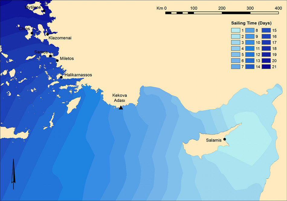
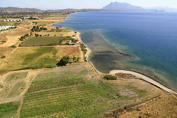
A critical parameter within our socio-spatial networks centres on the changing practice of seafaring, which includes innovations in nautical technology and navigational knowledge, as well as adaptations to changing marine environments. On a basic level, winds, currents and other variables create an uneven topography for seafaring practice that must be factored into any model in ways that reflect the dynamism of the marine environment (e.g. Reference LeidwangerLeidwanger 2013; Figure 2). We must not underestimate the cognitive process of wayfinding, the accumulation of navigational expertise and the social context through which such understanding develops and is transmitted. The success of any maritime network is also dependent on vessels and infrastructure that are appropriate for maintaining efficient networks, but the emergence and decline of these networks are, by definition, closely linked to innovations and changes in ship and port/harbour design (Figure 3), navigational expertise and environmental shifts, from abrupt tectonic activity to the gradual silting of coastal landscapes.
Schematic representation of approximate sailing times from a hypothetical origin at Salamis in eastern Cyprus, derived using an anisotropic surface that accounts for certain environmental and technological parameters of seafaring in the Archaic Greek world: namely, predominant wind direction and strength, as well as rigging and sailing capabilities. For the underlying GIS methodology, see Reference LeidwangerLeidwanger 2013 (map by J. Leidwanger).

Aerial view towards two of the ancient harbours of Burgaz (‘Old Knidos’), on the Datça peninsula in south-west Turkey. The size and architectural details of the site’s four built harbours, several of which were in use at the same time, appear to respond to a range of different socioeconomic conditions and needs of the local residents (photo courtesy of N. Tuna).

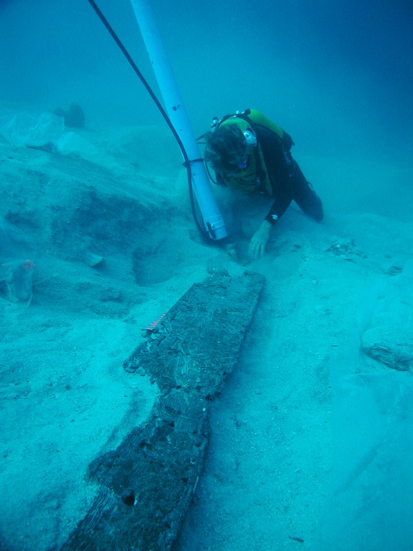
Excavation of the sixth-century-BC shipwreck at Pabuç Burnu, Turkey. Study of the assemblage has suggested a cargo of primarily agricultural goods stored in amphorae that circulated regionally within the south-east Aegean, while the remains of the hull reveal a laced construction technique appropriate for a modest venture (see Greene et al. 2008; photo courtesy of the Institute of Nautical Archaeology).

Shipwrecks do not necessarily constitute a straightforward ‘frozen’ representation of the geographical locations of networks, but the study of shipwrecked hulls and cargoes provides a window onto how maritime networks operated and who was involved in the transport stage of exchange (Figure 4). In many pre-modern societies, technological innovations in seafaring appear to represent responses to economic or socio-political needs for the transportation of larger cargoes or the increase in the geographical range of vessels. This is evident for certain shifts observable in the Mediterranean. For example, changes in the design of Egyptian and Levantine Early Bronze Age boats (towards large, sail-driven craft) seem to reflect a need for the movement of bulk goods, such as Lebanese cedar or wine and oil, rather than substantially increased spatial reach or time constraints, although the subsequent proliferation of such ships across the Mediterranean suggests more diverse priorities. Similarly, mortise-and-tenon construction, which was known from at least the Late Bronze Age in the eastern Mediterranean, might have been widely adopted across the whole region during the Classical period, not because it enabled the production of larger, more stable vessels capable of longer journeys—which it probably did—but because, at least initially, of the practical necessities of sturdier hulls for naval warfare. Technological innovations such as advances in shipbuilding and harbour design may have as much to do with the perceived necessity of a dedicated class of seagoing merchants, and the resources that demanded, as to any particular goal of movement or transportation.
Scale
Reference TartaronTartaron (2013) has presented an explicit model for thinking about maritime networks where coastscapes, maritime small worlds, regional and inter-regional maritime spheres can overlap and integrate. This multi-scalar approach has two advantages: it engages quite directly with the notion put forward by Horden and Purcell (2000) of fragmented micro-ecologies, and it conveys effectively the conjoined social and spatial character of maritime interaction. In some cases coastscapes may aggregate to form small worlds, but this process is dynamic and varied. It need not always reflect bottom-up initiatives any more than the reconfiguration of these small geographical entities need be the result of hierarchical imposition from above. How might these complementary spatial entities interact to form stable or ever-changing network patterns? In what ways could practical manifestations of network dynamics at one scale have brought about shifts in structure at other scales, and how might other complementary scales of network activity have mediated these interactions? The archaeologist interested in one particular scale of connectivity—say, the regional level—ignores other network activity at his or her peril.
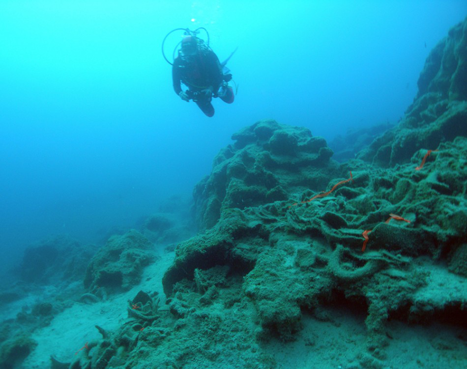
Remains of the seventh-century-BC shipwreck at Kekova Adası, Turkey. The cargo included transport jars drawn from a wide area that appears to have included eastern Cyprus, Corinth, and the region of Samos or Miletus. (see Greene et al. 2011; photo by J. Leidwanger).

We could also think about the interplay between temporal and spatial. What sorts of maritime spheres tend towards resilience and which show greater inclination to shift? Tartaron’s (2013) maritime small world in the Saronic Gulf (Greece) appears remarkably resilient in the long run. Did other small worlds or even coastscapes endure longer than the regional and inter-regional networks, as the Saronic example could lead us to expect? Is there a scalar ‘sweet point’ for stability within or among these scales? Regional scales have often dominated in recent models of cultural interaction and the construction of socio-spatial relationships, although the scale of such regionalism can be quite fluid and often takes on vastly different geographical extents that necessitate precision in definition and analytical approach. Greene’s paper seemed to suggest potentially interacting scales of connectivity during the Archaic period, where one shipwreck at Pabuç Burnu (Turkey) reflects a certain scale, perhaps a small world in Tartaron’s typology, whereas another at Kekova Adası (Turkey) reflects a much wider sphere of interaction (Figure 5). Given the complex socioeconomic relationships behind such expansive maritime connectivity, as is evident in the Roman economy, we could also ask whether these phenomena provide examples of simple aggregation from the bottom up or, additionally, the effects of larger-scale structures on spatially and socially circumscribed interactions. To what extent were different seafarers or other agents behind different scales of network activity? How much and what types of information flowed regularly between networks? For example, a low-level trader might have had reliable knowledge about his or her own coastscape or small world, but not beyond. On the other hand, the ship owners and operators might have had access to a vast store of trans-Mediterranean maritime knowledge, but how was this transmitted or institutionally insured? The implications should be significant for how we understand patterns of movement across different spatial scales and even how we think about and represent fundamental concepts such as ‘routes’: to what extent does the notion of ‘routes’ hold for each of these scales of activity? It is critical that we be explicit about the scale of analysis and formulate hypotheses that reflect what a network at a particular scale is for, what structure may best serve that function—with due awareness of equifinality—and how maritime networks operating across multiple scales might interact and be effectively analysed.
Long-term perspectives
A third critical theme can be identified: the need for a diachronic approach to maritime networks. While one of our workshop goals aimed specifically to address the issues of continuity and discontinuity across critical junctures of the ancient world, it is clear that bridging periods with long-term perspectives presents acute challenges. This need is particularly evident in the examples cited above, where the mechanisms and patterns of maritime connections could shift according to the changing social conditions that guide our socio-spatial networks. Conversely, are there entanglements and locked-in trajectories of such a kind that once a set of connections are established it takes a considerable disruption to de-establish them? In this way, to understand Late Roman networks one really needs to understand how their sea routes were inherited from earlier Roman and Hellenistic traditions. This could in turn require projection back to the Classical and Archaic periods and perhaps earlier still, suggesting that early Iron Age systems of seaborne exchange were not total reinventions, but built on certain structures of pre-existing networks from the end of the Bronze Age and, at times, even before. Given the persistence of many of the essential physical parameters that are fundamental to maritime interaction and the agency that networks themselves can achieve, is there meaningful ‘path dependency’ or other forms of continuity across these transitions? Or are maritime networks wholly recreated over time according to changing technologies, relationships and products? Major changes in seafaring and harbour technology may fundamentally shift the human relationship with the environment. When, however, basic technologies of seaborne connectivity remained essentially unchanged—as, for example, seems to be the case from the Hellenistic into the Roman world—should we expect some degree of resilience (or simply inertia from the considerable ‘sunk costs’ of maritime investment) of maritime networks, even in the face of shifting supply and demand, evolving socio-political institutions and changing political and military authorities? What forms of social institutions—religion, kinship, ethnicity—might have served variously to anchor networks or to undermine them? The work of Mills et al. (2013) offers a glimpse of the potential for dynamic network change associated with major demographic transitions and the emergence of new religious movements from another part of the world—the American Southwest. Considerable emphasis has been placed on the operation of connective structures at particular periods in the Mediterranean region, but the dynamic nature of network analysis implies that much could be gained from a long-term perspective that bridges assumed ‘transitional junctures’ between periods, cultures and disciplines: between the end of the Bronze Age and the Iron Age, from the late Classical era to the international Hellenistic world and the coming of Rome, and across and beyond the dissolution of the Roman state in the medieval west.
Model-making
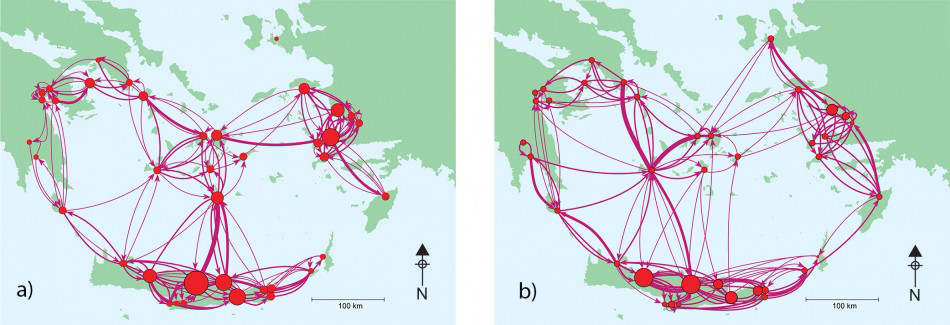
Choosing an appropriate model for understanding different scales and dynamics of seaborne connectivity is also crucial, and the improper use of models can create problematic results as well as a misleading sense of objectivity. The dangers are particularly acute in the uncritical selection of ‘off-the-shelf’ models. Models borrowed straight from social network analysis are not necessarily applicable, as they are designed for complete networks where social relations between actors can be directly observed. For ancient networks we are obliged to work from material proxies, which are used to reconstruct social links that are no longer directly visible. Reference Sindbæk and KnappettSindbæk (2013) has argued that this is more akin to network synthesis than actual analysis. Even if we decide to pursue techniques drawn from social network analysis, we are still faced with a wide range of options. It is important to distinguish between data models and theory models (Reference ReadRead 2008). At their best, data models enable us to use multivariate datasets to infer relationships and societal structures at different scales and different times with details that go beyond the merely qualitative. This ability to extract patterns from bewilderingly large aggregations of artefacts and other information has its problems, but it is only possible because of growing computing power and toolkits with increasingly friendly interfaces for the programming novice. We would particularly cite UCINET, Pajek, Gephi and R—each offering particular advantages and disadvantages. On the other hand, theory models function at an ideational level, with a very different set of issues concerning the ways in which they inevitably encode our systems of beliefs about the societies that they purport to postdict. Having said that, there are very similar computational problems, although some models are quite straightforward and do not require much, or at times any, computer power: proximal point analysis effected ‘on the back of an envelope’ in simple cases can still generate valuable insights (Reference BroodbankBroodbank 2000). Other theory models, such as Ariadne designed by Tim Evans, have been tailor-made for archaeological settings, but can suffer from the perception that they are too narrowly fitted to specific regional and temporal questions (Figure 6). At our workshop, Evans presented a systematic comparison of different theory models, breaking down their characteristics methodically, a sign that archaeological approaches to network analysis are maturing from an early stage of rather haphazard application. More such comparisons are needed if we are to differentiate and effectively use models.
Aegean maritime networks before (a) and after (b) the eruption of Thera. The networks have sites labelled (in size) by rank and links (in thickness) by exchange flow. The resilience of the network to such a catastrophe is clear. The shift in the pattern of exchange after the eruption is striking, with an emphasis on the north-east of the network, where there is archaeological evidence for strong post-eruption activity (maps courtesy of R. Rivers and T. Evans).

It is important to distinguish between ‘most likely networks’ (epistemic approach), which make best use of our limited knowledge, and ‘most beneficial networks’ (ontic approach), which posit plausible social behaviour. These considerations seem fundamental to our maritime network approaches. The problem is that we risk creating network outputs that reflect exactly what we are seeking, forced to conform by the selected inputs. We can be saved by what Ray Rivers calls ‘Goldilocks scenarios’, where we can find networks that are ‘just right’ in keeping a precarious balance and which have a strong level of postdiction. While a certain degree of expert intuition is valuable and often quite efficient, interpretations may be more convincing if also underpinned by careful and explicit accounting of the underlying decision-making in the production of models. Such models often tend to impart a sense of objectivity, so awareness of the different options and capacities, parameters and outputs, and of course their different meanings and interpretive potentials, is a critical step towards achieving a network model of maritime interaction that lives up to good scientific standards. The assignment and weighting of variables in our inputs should likewise be a point of critical interest, particularly given the difficulty of quantifying the social variables that are fundamental to our socio-spatial maritime networks. Being precise and explicit will be of prime importance for any quantification of such tricky social variables that undertake to reflect human behaviours, intentionality and the like, variables that have proven challenging in past network studies (e.g. Reference MalkinMalkin 2011). How should we proceed in responsibly building models of Mediterranean connectivity when empirical data needed to inform our input variables are partially or even wholly lacking?
Datasets
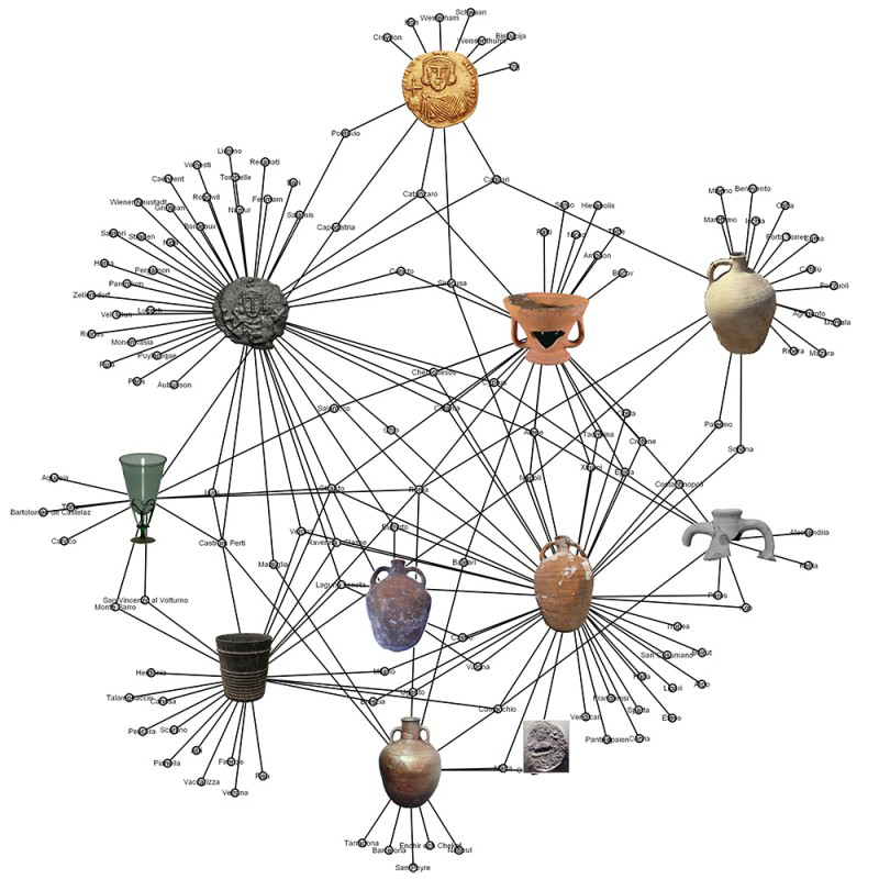
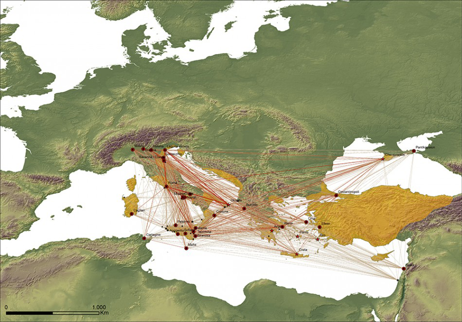
What might a maritime network dataset look like? To date, archaeological network analysis has most often incorporated a collection of sites as nodes, with their connections and interactions plotted as links. This approach may seem familiar and relatively straightforward, in that it differs little from a traditional archaeological distribution map, with more lines between certain sites than others and some sites appearing more obviously dominant within the network. Such a dataset and approach does, however, require a sequence of many decisions regarding priorities and definitions, and it can run the risk of presuming, for example, that sites come first, followed by their connections rather than each constituting the other. Should all possible types of site be included—whether settlement, cemetery or sanctuary—or only settlements? Shipwrecks provide one of our best proxies for individual relationships across maritime space, but the interpretation of their cargoes and other finds is hardly straightforward. Can a ship be viewed as a ‘mobile node’ in a broader network system, or perhaps as a self-contained network of its own? How best can we plot interconnections within the cargo and personal elements aboard a ship alongside the theoretical points of origin (for the cargo components or the ship itself), destination and the route followed? How, then, should the links between sites be established? One option is simply to measure geographical distance and connect sites based on some hypothetical likelihood of their interaction given certain physical or social parameters (e.g. transport technology, resource distribution, political boundaries). Another option is to use archaeological data, such as pottery imports, as proxy evidence for actual connections between sites: if a particular transport amphora known to be the product of one site or area is then found at another location, one can justifiably draw a link, although of course the connection in reality might have been quite indirect. A third possibility is not to work from the actual circulation of objects, but from shared styles, which can often be taken implicitly as a sign that two sites shared a common tradition and hence interacted in some measure. Paul Arthur and colleagues have attempted such an approach with Byzantine globular amphorae, made in different areas, but belonging to a broad Byzantine koiné (Figures 7 & 8).
Byzantine artefact types across the Mediterranean. Two-mode networks allow one to study the dual perspectives of the actors (sites) and the events (occurrence). Examination of shared material culture attributes can lead to the definition of links between nodes (illustration by P. Arthur, M. Leo Imperiale and G. Muci).

Affiliation network showing early medieval sites connected by edges expressing affiliations based on the co-occurrence of artefacts and the distribution of globular amphorae types in the network. The map highlights the coincidence of the network with the extension of Byzantine territory in the first half of the eighth century (in yellow; red dots indicate major sites, while stars mark the location of globular amphorae kiln sites; the thickness and tone of the edges represents the strength of affiliations) (map by P. Arthur, M. Leo Imperiale and G. Muci).

These points may seem quite basic, but different network approaches currently employ each of these options and these choices significantly affect the types of results we can expect and the nature of the interpretations we can in turn draw. Each is a relatively straightforward possibility, and one could easily go into more detail, such as whether links between sites are assumed to be directed or undirected, or whether we should measure simply presence and absence or undertake quantified measures of similarity. The abundance of not only pottery, but a range of archaeological and historical/documentary sources, provides an opportunity and a challenge to open our models to the types of massive datasets that the ancient Mediterranean offers, including coinage, inscriptions, papyri and other texts. Relationships in the past were constituted by the flows of things and by ideas about how to make and use objects in communities of practice (e.g. Reference KnappettKnappett 2011). How can we elucidate the spatial and relational meanings encoded in the peculiar patterning of some religious and ritual phenomena attested in the epigraphic record or the presence of cultic objects? Could Mediterranean myth both contribute to and reflect the product of maritime networks spanning a widely dispersed cultural world? Given our obvious interest in the socio-spatial nature of maritime networks, how can we bring this cumulative weight of varied and quantified data for connectivity to bear on such network explorations?
Next steps
We do not, by any means, wish to create a homogenous, single path towards maritime network study; one would hope that a range of viable approaches would ultimately be advantageous in addressing more historical and archaeological questions and raising further issues. Nonetheless, more explicit dialogue concerning long-term histories and the changing social motivations for, and hence scales of, connectivity from the Neolithic to the Middle Ages, would surely promote a greater degree of commensurability in the questions different specialists ask. Perhaps more pressing is the need for some degree of standardisation in the datasets we generate: currently, they vary so dramatically from one period and region to another that it becomes extremely difficult to make sensible and valid comparisons across time and space. One logical step would be to push for more open-source datasets that adopt a common focus and character and that can be used freely by different researchers testing new techniques. What is clear from other projects in other areas of the world is that to accomplish the goals we outline here, there must be multi-institutional collaboration and data sharing. Operating between these conceptual and empirical levels are the models we choose to use in assessing connectivity. While one contribution of network models is the obligation they place on us to standardise our data sufficiently to enable comparisons, there remains considerable uncertainty as to how to choose the most appropriate network model from those available. In parallel, it is important for standardised theoretical models to be available in a form that makes their use as simple as possible. This is already happening with Tim Evans’ Ariadne suite, but more can be done. Only with the increasing use of these models will we begin to understand their limitations and when their use is appropriate. With initiatives such as the ‘Connected Past’ project (see http://connectedpast.soton.ac.uk/) and indeed this workshop, we hope that some of this uncertainty will be reduced through specialist input and consultation.
The question then arises as to how we could properly present these initiatives to a wider scholarly community—both specialists in antiquity as well as those working on all aspects of past and present iterations of what we consider socio-spatial networks—and eventually, to an interested public. We must likewise be ready to assess critically our outputs. With the ever-growing expertise and experience in archaeological network analysis, it should be possible to establish parameters and disciplinary expectations for network inputs and outputs, not unlike those devised for field survey methods and results, for example. We clearly need greater commensurability in questions, datasets, methods and expected outcomes if we are to capitalise effectively on the Mediterranean’s exceptionally rich and varied long-term history of seaborne connectivity.
Acknowledgements
The workshop ‘Networks of Maritime Connectivity in the Ancient Mediterranean’ was held from 31 October–2 November 2013 at the University of Toronto. The generous financial support of a Connection Grant through the Social Sciences and Humanities Research Council was integral to the success of the event, as were the financial resources of the Walter Graham/Homer Thompson Chair in Aegean Prehistory and the Aegean Material Culture Lab. For additional logistical and financial support, thanks are due to the Royal Ontario Museum, as well as the Department of Art and the Archaeology Centre at the University of Toronto. We thank the referees for their helpful suggestions on a prior version of this text.