

Introduction
To sail a ship safely, a whole crew works together: someone needs to decide where to go, others need to operate the rudder, and yet others have to work the sails. Each of these people has a specialized skill set and each of them works with a specific set of tools. Early modern Chinese sources suggest that one of the most important roles aboard a ship was that of the huozhang 火長 (literally: “fire chief”; also written as huozhang 夥長, literally: “group chief”), whom we can identify as the navigator or pilot of a ship, but who also performed other duties.Footnote 1 Huozhang worked closely together with the people operating the rudder, the duogong 舵工 (steersmen), and their presence is attested for a range of different voyages. They accompanied Zheng He 鄭和 (1371–1433) in the early fifteenth century into the Indian Ocean, manned ships that carried Ming and Qing envoys from Fuzhou to the capital of the Ryukyu Kingdom, Naha, and took an active part in trading voyages in East and Southeast Asia. They were essential crew members, working together with other personnel on the ships.
Only few studies so far have considered the composition of Chinese ship crews.Footnote 2 Previous studies have acknowledged the importance of huozhang, but with few exceptions have not investigated the actual role of the huozhang. Footnote 3 In the most detailed study so far, Liu Yijie summarizes sources showing that huozhang were essential personnel in charge of the compass.Footnote 4 However, research is still lacking concerning the question of how huozhang fit into the general composition of the crew and how their sailing practices related to the tools they had available. One difficulty in studying Chinese sailing practices is that most Ming and early Qing sources were written by scholars with little reason to know much about maritime matters. Even sources that huozhang might have used were often preserved through the hands of scholars. We therefore have no document from early modern China that is directly linked to a huozhang. The consensus so far, based on these sources written by Ming and Qing scholars, is that sailing manuals, also known as rutters or zhenjing 針經 (literally: needle texts) in Chinese, enabled huozhang to safely find routes between harbors in connection with the compass. However, when reading the Chinese sources more closely and supplementing it with material evidence and considerations of practical navigation and of the composition of the crew, a more complicated picture emerges: the duties of huozhang went beyond simply navigating. Based on these considerations, this article therefore aims to examine the details of the role and technique of huozhang and the implications this has for our understanding of sailing practices by Chinese navigators in the period between the fifteenth and early eighteenth centuries.
Many People Sail a Ship
Multiple sources from the fifteenth to the eighteenth century list the types of personnel necessary to sail a ship. These include texts written in connection with the early fifteenth-century voyages of Zheng He to the Indian Ocean, records on Fujianese trade, records of missions between Fuzhou and Naha, and military records. Understanding these lists comes with problems. Terms might not be clear or easy to render into English, as many of the terms are part of a specialized nautical vocabulary. Nevertheless, the personnel lists do provide a glimpse into the composition of ship crews. To avoid associations with the terminology of European ship crews, in which duties were divided differently, I will use either literal translations or the Chinese transcription of the job titles mentioned in the sources.
In particular, the records made in connection with Zheng He provide a wealth of information. One source includes a list of the type of crew members, and another a record of rewards for outstanding service after the voyages, giving job titles and the amount of compensation.Footnote 5 Featuring prominently on both lists are military personnel, doctors, interpreters, and huozhang. There were even two types of huozhang, foreign (fan huozhang) and presumably “Chinese” huozhang, in line with the widespread practice in the Indian Ocean of hiring navigators from various locations. The foreign huozhang received compensation on the level of imperial doctors, much more than the other huozhang, who received the same as ordinary soldiers and interpreters. The source gives no indication as to why the foreign huozhang were singled out. The lists mix personnel needed for sailing (huozhang, sailors, steersmen), personnel vital for the mission (translators, military personnel), and personnel needed to keep the ship running (carpenters, doctors). The lines between these categories were certainly murky. Translators might also have been vital to keep the ship sailing: they could facilitate communication between huozhang and foreign huozhang, for example. Not all the personnel listed were directly necessary to sail the ship, but they were certainly essential for the success of the voyage.
Trading vessels sailing to East and Southeast Asia needed different compositions of personnel. The Dongxiyang kao 東西洋考 (Records of the eastern and western ocean, 1618), written by Zhang Xie 張燮 (1574–1640), a scholar who interviewed sailors in Zhangzhou 漳州, Fujian, provides information for Fujianese trading vessels. He starts with the trading side of personnel, explaining that a bo zhu 舶主, a shipmaster, is in charge, and all the merchants obey him. The second person is called caifu 財副 (literally “money deputy,” possibly overlapping completely or partly with what is known as “supercargo” in the English-speaking maritime world) who oversees the financial accounts. A zongguan 總管 (general manager) organizes things aboard the ship and acts as spokesperson for the shipmaster. Next is the zhiku 直庫 (literally “[person] in charge of the depot”), who according to Zhang is in charge of weaponry. Turning to the crew needed to sail the ship, Zhang writes that they include people who climb up the masts (aban 阿班);Footnote 6 and two people each to take care of the anchor (touding 頭椗, literally “head anchor,” and erding 二椗, “second anchor”), the rigging and sails (daliao 大繚, literally “big entanglement” and erliao 二繚, “second entanglement”),Footnote 7 and the rudder (duogong 舵工, literally “rudder worker”). Lastly, Zhang mentions the huozhang, who “takes care of the needle” and because “the routes across the sea are vast, all listen to his commands.” (其司針者名火長, 波路壯闊, 悉聽指揮).Footnote 8 Compared to the list from Zheng He’s voyages, the Dongxiyang kao focuses more on the operation of the ship itself, but it also mentions the financial and trading side of sailing, and emphasizes that the administrative side of a ship operation was separate from navigational aspects.
Around a century later, the Japanese Nishikawa Joken 西川如見 (1648–1724) recorded the composition of the crew of Chinese trading ships, also based on records from Zhangzhou.Footnote 9 Huozhang, duogong, and people in charge of the anchor and climbing the mast are listed first, before Nishikawa turns to the administrative side, listing the person in charge of finances and cargo (caifu 財附) and general manager (zongguan). The last four people on Nishikawa’s list are people in charge of a sampan (a small boat to easily go ashore, shanpan gong 杉板工);Footnote 10 general sailors (gongshe 工社); the person responsible for rituals and offering incense (xianggong 香工); and finally the ship master (chuan zhu 船主), who is said to have no role on the ship itself but to take care of the cargo and make other management decisions. The general division into navigating, ship operating, and administrative / financial personnel overlaps in Zhang Xie’s and Nishikawa Joken’s texts. Both job titles and divisions of labor seem to have stayed the same in the case of seventeenth- and eighteenth-century Fujianese trading vessels.
Late-seventeenth to mid-eighteenth-century trade records made in Manila and Nagasaki provide some information about the make-up of crews and names of people, including huozhang, aboard ships. Several inspection records of Chinese ships arriving in Manila in 1744 were signed by Spanish inspectors, as well as three crew members from the Chinese side: the ship master, the caifu (treasurer / supercargo), and either a huozhang or a duogong. Footnote 11 Similarly, the Japanese government conducted interviews on Chinese ships arriving in Nagasaki to keep a tight control on trade. Records of these interviews, known as Tōsen fusetsu gaki 唐船浮説書 (Records of rumours from Chinese ships) or Ka-i hentai 華夷変態 (The change of the civilized and the barbarian), survive for the period between 1644 and 1728.Footnote 12 A few of these reports include information on the number of people on board ship and list at the end several or even all crew members by name and position.Footnote 13 A report of a ship arriving in Nagasaki from Fuzhou in 1696, for example, lists the names of the ship master (chuantou 船頭), the person in charge of finances (caifu), the head of merchants (ketou 客頭), the huozhang, the duogong, and the general manager (zongguan).Footnote 14 In two other cases, both of ships arriving in 1703, the records list the names of all crew members. In one case, the ship from Fuzhou carried twenty-eight people, but the records identify only the ship master and treasurer by their titles,Footnote 15 while the records of the second ship, from Nanjing, with nineteen people onboard, identify the ship master, a merchant (ke 客), and the duogong. Footnote 16 In both the Manila and Nagasaki records, the ship master appears every time; with the exception of the 1703 ship from Fuzhou, all records list at least one huozhang or duogong. For trading purposes, the ship master and caifu presented the most important personnel, and the authorities in both Manila and Nagasaki might have wished to include one person responsible for navigation in the signature.
Records related to voyages sponsored by the Ming and Qing states going to the Ryukyu Kingdom provide slightly different information again. In 1579, Xie Jie 謝杰 (1537–1604) had gone to Naha. Several years later, he recorded that eight huozhang were serving in pairs on the ship, and that they worked closely with sixteen duogong grouped into four groups of four.Footnote 17 Based on a voyage taken 150 years later to the same destination, Xu Baoguang 徐葆光 lists twenty-two crew members on his ship, including one main and one deputy huozhang (zheng huozhang 正夥長, fu huozhang 副夥長).Footnote 18 The other twenty people included two steersmen (duogong), and people in charge of the anchor and the rigging, just as Zhang Xie had stated in his Dongxiyang kao. Xu Baoguang, however, adds others, among them a person in charge of incense (xianggong) as in Nishikawa Joken’s text, and two cooks (zongbu 總餔), but no administrative positions like the ship master or caifu. Footnote 19 As this was an official voyage, the lack of personnel related to trading activity is not surprising.
Military vessels had different requirements. A mid-sixteenth-century military handbook mentions that military ships needed first a robber-catcher (budao 捕盗), probably reflecting the purpose of the mission: to go after pirates. The source continues to list personnel needed to sail the ship: people in charge of the rudder, the rigging, and the anchor, but huozhang appear nowhere.Footnote 20 This raises the question: Who was responsible for navigation on military vessels? Given that military ships mostly only patrolled a small section of the coast, navigating must have required a very different set of skills from navigating to Southeast Asia or even the Indian Ocean. Was a huozhang only someone who sailed far from the coast?
That huozhang were indeed needed only when sailing further away is mentioned in Huang Shujing’s 黃叔璥 1722 Taihai shicha lu 臺海使槎錄 (Records of being an envoy in the Taiwan Strait). To trade within the Qing Empire, a ship needed a ship master and a duogong, in addition to people climbing up the masts and taking care of the rigging, anchors, and shanpan, as well as a cook and ordinary sailors. Ships going to trade abroad (waiguo 外國) additionally needed more personnel, among them a caifu (treasurer / supercargo), two huozhang, and an incense master (xianggong).Footnote 21 Huang Shujing’s text very explicitly reminds us how important it is to consider the type of voyage before we draw any conclusions.
Each of the sources speaks of a different type of voyage over a period of three hundred years. Unsurprisingly, therefore, the personnel lists differ, as each list describes a different kind of voyage.Footnote 22 Food and medical care were surely necessary on all voyages, but not all compilers of ship crew lists mention personnel responsible for these aspects. The omission of doctors and cooks could mean one of two things: either the lists are incomplete, or sailors were supposed to cook and care for themselves. Looking at the personnel mentioned for any type of voyage, i.e., those needed to physically sail the ship, reveals a certain set of crew members mentioned consistently. Absolutely central to all the lists are the steersmen, termed duogong in all sources. However, not all sources list huozhang. Especially for shorter voyages, huozhang seem to not have been necessary. Could duogong fulfill part of the duty we assume huozhang to have had? In the following section, I will examine what the sources tell us about their duties and relationship.
Huozhang, Co-workers, and Authority
Several sixteenth- to eighteenth-century sources explicitly state that huozhang oversaw the compass. Xie Jie, who served as an envoy to Ryukyu in the sixteenth century, and Zhang Xie in his early seventeenth-century Dongxiyang kao both state that the huozhang “attended to the needle” (si zhen 司針).Footnote 23 Sources from several decades to a century later, Liu Xianting’s 劉獻廷 (1648–1695) Guangyang zaji 廣陽雜記 (Miscellaneous notes of Guangyang), Nishikawa Joken’s Zōhō Ka-i tsūshōkō, and Xu Baoguang’s Zhongshan chuanxin lu, list more duties. Liu Xianting mentions that aside from “watching [the compass] day and night,” the huozhang “knew the depth of the water and the color and smell of sand” (夥長晝夜視之 … 其水之淺深, 泥之顏色臭味, 皆知之。).Footnote 24 Nishikawa explains: “Huozhang: the person who takes lead in being at sea. His duties are knowing the way of the compass; measuring the sun, moon, and stars; thinking about the weather; and examining geographical features” (夥長: 海上ノ乗方ヲ主ドル者也. 羅經ノ法ヲ能知テ, 日月星ヲ計リ, 天気ヲ考へ地理ヲ察スル役ナリ).Footnote 25 Xu Baoguang explains the role of the huozhang as follows: “The main huozhang takes care of the needle compass. The deputy huozhang manages the needle room and takes care of the water hook and three long ropes to measure the depth of the water” (正夥長主針盤羅經事. 副夥長經理針房兼主水鋾長綆三條候水淺深).Footnote 26 According to Liu, Nishikawa, and Xu, a huozhang was a very knowledgeable person who did much more than just minding the compass. He also performed a variety of tasks to decide where the ship should and could safely sail.
The role of the huozhang closely relates to that of the duogong. Based on his experience of being an official envoy on a ship from Fuzhou to Naha, Xie Jie explains that huozhang and duogong work closely together in teams of two huozhang and four duogong (who work in four shifts), pointing out that “wherever the needle points, the rudder follows” (針之所向則舵隨之).Footnote 27 while Xia Ziyang 夏子陽 and Wang Shizhen 王士楨, envoys to Naha in 1601, are more explicit about the hierarchy: “The duogong listens to the commands of the huozhang” (舵工聽命於夥長焉).Footnote 28 Nishikawa Joken, too, makes clear the close relationship between huozhang and duogong. He writes that the duty of the duogong involves “joining his heart with the huozhang” and that he “knows the wind and conquers the waves” (彭[sic]長ト心ヲ合セ, 風ヲ辨ジ, 濤ヲ凌グ).Footnote 29 A slightly different relationship between huozhang and duogong is described by Liu Xianting. He explains that “once an island / mountain is seen, things are [in the hands of] the duogong and the duty of the huozhang is over” (一見山, 則事在舵工, 夥長之任卸矣).Footnote 30 Liu’s remarks suggest that the role of the huozhang was necessary only in the open seas, and as soon as the ship was in sight of land, the duogong could take over. But out in the open seas, the huozhang was in charge and told the duogong where to go. The duogong then implemented practical navigation by steering the ship.
Many ships probably carried more than one duogong and huozhang. Most sources discussed above speak of two duogong, while the Taihai shicha lu makes a distinction between short voyages needing only one duogong, and voyages abroad needing two. According to the early seventeenth-century Dongxiyang kao, the two worked in shifts, while the early eighteenth-century Zhongshan chuanxin lu and Taihai shicha lu divided their roles into a “main” (zheng 正) and a “deputy” (fu 副) duogong, implying a hierarchy between the two.Footnote 31 The number of huozhang is mentioned less often. The Dongxiyang kao can be interpreted as speaking of only one, while the Zhongshan chuanxin lu and Taihai shicha lu mention a “main” and “deputy” huozhang in parallel to the situation for the duogong. Sources written by envoys to Ryukyu in the late sixteenth and early seventeenth centuries, however, explain that ship crews consisted of twice as many duogong as huozhang. Xie Jie mentions sixteen duogong and eight huozhang who work in four shifts.Footnote 32 Xia Ziyang and Wang Shizhen explain that twice the number of duogong is needed, as steering the ship is a physically demanding job, in contrast to watching the needle.Footnote 33 We therefore have no conclusive answer on the number of huozhang and duogong, but most sources point to there being more than one on board, dividing responsibilities. As mentioned above, Xu Baoguang suggests that the main and deputy huozhang fulfill different duties: only the main huozhang was directly concerned with the compass, while the deputy had responsibility for the compass room. In general, however, the division of labor among huozhang was achieved in one of two ways: by working in shifts or by assigning a main and a deputy huozhang.
Hierarchy and organization guided colleagues fulfilling the same duty, but also assured that all crew members knew their place. To understand hierarchy, the type of ship and the purpose of voyage are particularly important. On military ships, which included those for Zheng He’s voyages, military personnel were probably in charge; generals received the highest compensation after the Indian Ocean travel. Records of trading ships, on the other hand, hint at a distinction between the operation of trade and the operation of sailing. The Dongxiyang kao explains that someone called “ship master” (bo zhu) was in charge, while at the same time, stating that “all listen to [the huozhang’s] commands.”Footnote 34 Nishikawa Joken confirms this sentiment: Not only does he claim that the huozhang “takes lead in being at sea,” but he also describes the role of the ship master (chuan zhu) as follows: “He is the head of the ship. He has no duty on the ship. He orders [when] to go to Japan to trade, informs the government, and decides the number of people for each ship” (船主 : 船頭ナリ, 船中ニテ役ナシ. 日本ニテ商賣ノ下知ヲシ, 公儀ヲ勧メ, 一船ノ人數ヲ治ム).Footnote 35 Similar divisions of labor between shipmasters and pilots are recorded for navigational practices in other regions of the Indian Ocean, such as the Persian, Arab, and Malay regions.Footnote 36 In other words: the shipmaster decided who went where, but as soon as the ship had set sail, the huozhang made all the decisions to assure a safe journey.
Rutters, Maps, and Images to Guide the Way
Chinese sources speak of several tools huozhang had at their disposal to find their way safely: sailing manuals, tools to measure the depth of the water, and others to measure the position of stars, incense sticks or hourglasses to measure time, and of course the compass.Footnote 37 In the following sections, I will focus on the two most prominent tools: sailing manuals and the compass.
Sailing manuals or rutters are usually called zhenjing (lit. needle texts), referring to the compass needle. Several copies of zhenjing survive from the sixteenth and seventeenth centuries, connecting China with other places in East and Southeast Asia and the Indian Ocean region.Footnote 38 These texts describe how to reach major ports in the region using compass directions and a time unit (geng 更; usually translated as “watch”; 10 geng are 24 hours) to explain the journey, naming islands, mountains, and other landmarks as places to sail past. They mostly use very formulaic language: “From place A, sail in the direction of x for y geng until you reach place B” (A用x 針y 更取/平 B). However, most of these extant sources are only preserved through the editorial intervention of Ming and Qing scholars. Even two manuscripts held by the Bodleian Library, commonly known as Shunfeng xiangsong 順風相送 (May favorable winds escort you, late sixteenth century) and Zhinan zhengfa 指南正法 (The correct way of using the compass, second half of seventeenth century), include prefaces that makes it clear that they are fair copies of rutters.Footnote 39 We therefore have texts preserved that record the contents of the rutters but we have no actual Ming or early Qing rutter that was aboard a ship.
None of the lists and descriptions of the duties of the huozhang discussed above mention rutters, but several Ming and Qing observers refer to zhenjing and their use by sailors more generally. Zhang Xie in his Dongxiyang kao, for example, states that “from old times on, mariners had rutters [hanghai zhenjing]. They are all written in jargon and not easy to analyze. I have translated them [into standard language] and written them down” (舶人舊有航海針經, 皆俚俗未易辨說, 余為稍譯而文之).Footnote 40 Another text presents a similar sentiment: “The people at sea familiar with the sea routes use the compass [zhinan zhen, also known as luojing] to guide the way. They have passed down rutters [hanghai zhenjing]” (海人習知海道者, 率用指南針(即羅經)為其導向。相傳有航海針經).Footnote 41 Tei Junsoku 程順則 in his Shinan kōgi 指南廣義 (General description of the compass), a Ryukyuan work completed in 1708 based on a Chinese navigational text, also explains that in 1683 he received a book titled Hanghai zhenfa 航海針法 (The way of the needle for going to sea) from a Fujianese duogong who had come to Naha. The comment documents a direct interaction between the compiler of a text and a sailor who had such a text in his possession.Footnote 42 Early modern Chinese sailors relied on some form of text as a guide.
Analyzing the rutters more closely along with the remarks of some contemporary observers, however, paints a picture of the rutters as guidelines rather than actual sets of instructions. Comparing the actual environment with the description in the rutters reveals quickly that much vital information is missing. Warnings of shallows are less frequent than necessary and, in particular, the last step of reaching a harbor receives hardly any attention at all.Footnote 43 Rutters therefore cannot have been the only source of knowledge of huozhang and others who navigated. The introduction in one of the extant rutters even hints at navigators receiving help from people familiar with local conditions, stating: “If you have difficulties following the route, there are paths you can follow, and people you can ask” (行路難者有徑可尋, 有人可問).Footnote 44 Xie Jie’s description of his voyage to Naha provides an example of the ship not following the rutter. Instead of following the chain of islands of the Ryukyuan archipelago after having passed the northern tip of Taiwan, as rutters suggested, the ship sailed directly from Fuzhou to Kume 久米 Island, close to Okinawa Island. Xie explains that this way of sailing “is called to cross [the ocean] flying” (所云截流飛渡) and that nobody on the ship “looked at old texts” (不循舊章), most likely referring to rutters. For Xie, this was a scary experience, and he ends his description of the voyage with the comment: “Oh! It was so dangerous! While I am writing this down, I remember this past event, and I am low-spirited and feel dread” (嗚呼, 危矣哉!我執筆至此, 追惟往事, 不覺黯然鬼魂銷).Footnote 45 According to Stephen Davies, Xie Jie describes a perfectly valid way to sail, which made sure the ship did not accidently end up in the Pacific.Footnote 46 However, for the Ming envoy, not following the rutters turned the crossing into a scary voyage. Rutters provided only rough guidelines that needed to be adapted based on the navigator’s experience and added to by people knowledgeable about local conditions, a fact that Ming scholars did not necessarily understand.
Aside from rutters, navigators also had some form of maps or drawings at their disposal. One of the very few texts that directly connects huozhang to these rutters, a text related to the Zheng He voyages, explains that “from the sailors that were selected, those who had experience sailing into the ocean are called huozhang. They were employed as ship masters. The leaders were supplied with rutters and drawings (zhenjing tushi). When they used them, they were [fully] concentrated [on the zhenjing tushi]. It was very important and a big responsibility. Who would dare to be neglectful?” (選取駕船民梢中有經貫下海者稱為火長,用作船師。乃以針經圖式付與領執,專一料理,事大責重,豈容怠忽).Footnote 47 The exact form of these zhenjing tushi is unclear: Are they maps? Rutters with only a few drawings? Does the text refer to two things? Zhenjing and tushi? The Chinese term tu can refer to any kind of diagram, image, or painting but also to maps.Footnote 48 Given that navigation today, just like early modern European sailing, relies heavily on charts, and given that an extensive genre of coastal maps has existed in China from the mid-sixteenth century onwards, the first impulse might be to equate tu to maps, i.e., a representation of the coastlines as seen from above.Footnote 49 However, this is unlikely as no early modern Chinese map exists that would be suitable for sailing by, even among those that focus exclusively on coastal areas. Even in 1934, Lieutenant Forrest H. Wells of the US Navy remarked that he had been on a large number of Chinese trading ships without having seen a single chart.Footnote 50
Instead, zhenjing tushi were probably coastal views, drawings showing the shape of islands and coastlines as seen from a ship. We know that such drawings were used in the mid-nineteenth century on Chinese ships (one of them was captured from a ship in the mid-nineteenth century, Figure 1), and Wells confirms their usage for the early twentieth century.Footnote 51 Other sources point to sailors having used them centuries earlier.Footnote 52 Zheng Ruozeng’s 鄭若曾 1562 Chouhai tubian 籌海圖編, for example, combines a textual sailing instruction with an image of islands for the route between Taicang and Japan (Figure 2), a section titled “Explanation of the zhenjing tu to go to Japan” (Shi Wo zhenjing tu shuo 使倭針經圖說) in the table of contents.Footnote 53 This view is supported by the 1708 Shinan kōgi. This text explains that sailors had available needle books (zhenben 針本) and huatu 畫圖, and that the Chinese book that Tei Junsoku had received from the Fujianese sailor had included images of the flow of water and shape of mountains (shuishi shanxing tu 水勢山形圖), using terms that clearly indicate drawings and not maps. A manuscript copy of the work contains such images (Figure 3).Footnote 54 Although both these texts were edited sources, they provide a glimpse into what zhenjing tu might have looked like.
Page 6v of the so-called Yale map, which was captured from a Chinese ship in 1841. Beinecke Rare Book and Manuscript Library.

A section of the Chouhai tubian showing a written description of the route between Taicang and Japan with images of islands in the upper register. Chouhai tubian, juan 2, 6b–7a. Harvard-Yenching Library.

A page of the Shinan kōgi showing drawings of islands along the route between Fuzhou and Naha. University of the Ryukyus Library.

Chinese sources therefore point to both texts and drawings as tools for huozhang. Given the continuity in type of drawing in the Chouhai tubian and in the atlas captured from the ship in the mid-nineteenth century, as well as the explanation in the Shinan kōgi, it is likely that similar sources found their way aboard ships in early modern China. We have, however, no sources that tell us how and when huozhang consulted these sources. It is entirely possible that huozhang memorized the parts about the voyage they were embarking on and did not need to consult rutters or drawings on the way. In addition, neither the zhenjing nor the zhenjing tu provide a comprehensive and complete picture of navigational instructions necessary to safely sail from one port to another. Instead, they provided a guideline and a mental aid to find one’s way around East and Southeast Asia, requiring supplementation from experience.
When and How to Use the Compass
Sources describing the duties of the huozhang make it clear that one of his most important tools was the compass, known by terms such as zhinanzhen 指南針, luopan 羅盤, zhenpan 針盤, and luojing 羅經.Footnote 55 Rutters heavily rely on giving compass directions to guide the seafarer. Ever since its first mention on a ship in the late eleventh century, the compass became an indispensable object aboard ship. Without it sailors would be lost at sea.Footnote 56 Or at least, that is the common narrative in much of the secondary literature.Footnote 57 Even though the compass is omnipresent in assumptions about sailing, there is very little research on the compass itself. Much of the literature simply mentions the compass as one of the “four great Chinese inventions,” describes the compass rose, and takes its use by sailors for granted, in part because scholars tend to focus on rutters that describe voyages by using compass points.Footnote 58 The most in-depth recent discussion of the Chinese compass by Stephen Davies breaks with many assumptions, convincingly arguing that the object—a compass itself—is not as important as a mental compass that divides space into directions.Footnote 59 This is not to say that no Chinese sailor ever used the compass as object but that a more nuanced discussion is necessary.
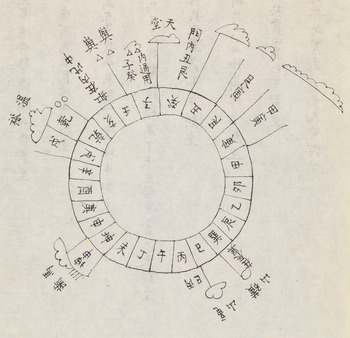
The design of the Chinese maritime compass rose is well understood. It consists of one ring with 24 points, while the European compass divides the circle into 32 points. The vocabulary of the compass directions is made up of eight of the ten heavenly stems and the twelve earthly branches, combined with four characters from the Yijing trigrams. The names for these compass points appear consistently in the rutters to give a direction, and several works related to the maritime world from the early seventeenth to mid-eighteenth centuries illustrate this compass rose (Figures 4–7).
Compass rose on the Selden map. Early seventeenth century. Bodleian Library Oxford.

Compass rose from the manuscript rutter Zhinan zhengfa 指南正法. Second half of seventeenth century. Bodleian Library Oxford.

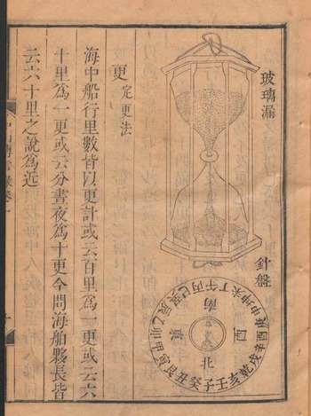
An illustration of a compass next to an image of an hourglass from the 1721 Zhongshan chuanxin lu. Staatsbibliothek zu Berlin.

A page of the Shinan kōgi showing a compass rose. University of the Ryukyus Library.

By comparing written records and extant objects, we gain an understanding of compass design and its changes. In the early fifteenth century, a source related to Zheng He’s voyages mentions a “floating needle in the water, which points the direction for the ship to go” (浮針於水, 指向行舟).Footnote 60 The use of a floating compass is also confirmed in the Shunfeng xiangsong, which describes that one has to put the needle on water.Footnote 61 To my knowledge, no such Chinese floating compass still exists.Footnote 62 A late sixteenth-century source comments that Chinese sailors had used wet compasses (shui luojing 水羅經), but because of attacks during the mid-sixteenth century by Japanese pirates, who used dry compasses (han luojing 旱羅經), Chinese sailors started to adopt the latter.Footnote 63 From the late eighteenth to nineteenth century, a range of dry mariner’s compasses exist (Figure 8).Footnote 64 These are small compasses that fit in one hand with a needle suspended in the middle and the usual compass rose on the outside, often with a lid. The dry compass required protection from the vibrations of the ship. To achieve this, Liu Xianting states in the late seventeenth century, the dry compass was placed in a box, which was then put on top of sand to keep it level.Footnote 65 This practice of suspending the compass on sand (or rice) is still attested in the early twentieth century, and, according to Wells, “cushion[s] the instrument against shock and vibration.”Footnote 66 During the sixteenth century, the floating compass was slowly replaced by the dry compass, which then needed its own way of mounting. By the late seventeenth century at the latest, dry compasses were mounted on sand or rice.
Nineteenth-century dry compass. Science Museum, London.

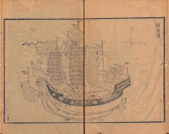
Xie Jie’s record of his voyage from Fuzhou to Naha provides a description of the workplace where the huozhang used the compass. He writes that “the place of the people in charge of the needle is very secluded; they cannot see a single thing on the outside. There is only an opening in a small wall facing the rudder door. The hope is that this will [help them] concentrate. In the needle cabin, a light burns, and so night and day cannot be discerned” (司針之處甚幽密, 外物一無所睹, 惟開小牅, 與舵門相向, 欲其專也。針艙內燃長明燈, 不分晝夜).Footnote 67 Xie Jie assumes that the compass played a crucial role in navigating, but he also describes it as something kept away from plain sight. Given that Xie Jie describes the compass room as completely dark and secluded, it is possible that he was never allowed in there. That there indeed was such a room on some ships, at least on ships sailing between Fuzhou and Naha, is confirmed in two further accounts of envoys between the two cities: Xia Ziyang and Wang Shizhen speak of a “secret room” (mishi 密室), where the compass is kept; and Xu Baoguang’s Zhongshan chuanxin lu includes an illustration of a ship with a room marked as “needle room” (zhenfang 針房), which does not seem to have any windows (Figure 9).Footnote 68 It is located below a shrine (shentang 神堂). In line with Xie Jie’s description, Xu Baoguang explains that next to the helm (duolou 柁樓) there is a small cabin (xiaocang 小艙), in which the compass is kept.Footnote 69 The compass and huozhang were thus close to the rudder and a shrine, again confirming that the huozhang and duogong had to work closely together, but also suggesting their close relationship with ritual practices, to be discussed further below.
Tribute ship from the 1721 Zhongshan chuanxin lu. Staatsbibliothek zu Berlin.

The sources discussed above attest to the presence and importance of the compass aboard ship but do not say when the huozhang consulted it. Several of the very early records of compass use in the maritime context explain that the compass was used mainly when the weather was bad. For example, an early twelfth-century text states: “The shipmaster knows the geographical features (of the coast). At night he watches the stars; during the day he watches the sun. If it is a cloudy night, he watches the south-pointing needle” (舟師識地理. 夜則觀星, 晝則觀日. 陰晦觀指南針).Footnote 70 The compass seems to have gained importance for navigating in the centuries that followed, as can be seen in the Dongxiyang kao, which explains that experienced sailors “rely only on the compass for guidance” (獨特指南針為導引).Footnote 71 Sources from the late sixteenth and early eighteenth century speak of the compass being watched around the clock, with Xie Jie describing the needle room as permanently manned in shifts, and the Shinan kōgi explaining that “those who are in charge of the compass (luojing) have to observe [the compass] carefully, day and night” (故主掌羅經之人﹐務要晝夜留心細看).Footnote 72
However, Stephen Davies raises several issues regarding the actual use of the compass on early modern Chinese ships. The iron nails on the ship, as well as the movement of the ship, would have made the compass usable only for finding very rough directions.Footnote 73 Cardinal directions could be determined using the sun and stars, a practice Nishikawa Joken in the early eighteenth century mentions as the duty of the huozhang, who should be skilled in “measuring the sun, moon, and stars.”Footnote 74 Even in the twentieth century, some sailors seemed to have used the compass in this way. Davies cites a communication with Nicholas Burningham, who had been on a ship in Indonesia in 1979. The navigator (nakoda) took the compass out of storage only because the weather was so bad that there was no other way to tell which way was north.Footnote 75 Liu Xiangting’s seventeenth-century description of the duty of the huozhang being over as soon as land was in sight further supports the idea that the compass was not needed for navigation at all times, particularly not when sailing close to the coast. The compass was an important device, of course, but it was not the only means of navigating.
At first glance, the compass being used only in case of unfavorable weather seems to contradict all the rutters and sailing route descriptions that rely on providing compass directions. However, Davies argues that a navigator would not necessarily need the compass itself, but only a mental compass rose. One could figure out north from the stars and the sun, and then deduce the other directions.Footnote 76 Compass illustrations also make this distinction between the concept of a compass rose and the actual physical object (Figures 4–7). The earlier two seventeenth-century images illustrate only a compass rose, not a compass, while one of the two later depictions includes the needle, thus making it an image of a compass. The image in the Shinan kōgi includes a diamond shape resembling a needle, but the caption, “Image of Duke Zhou’s 24 positions of the compass” (Zhou gong zhinan diluo ershisi wei tu 周公指南地羅二十四位圖), suggests that this, too, was meant as a compass rose. Furthermore, images of the compass (or even compass roses) are surprisingly rare—basically non-existent—in Ming manuals that illustrate all kinds of other maritime objects. The Chouhai tubian, for example, includes maps of the coast, images of ships, anchors, and weapons, as well as sailing route instructions. Yet, no floating or dry compass is illustrated. In fact, I am not aware of any illustration of an actual compass dating before the early eighteenth century.
The compass rose as a mental tool was much more important for navigating than the physical compass. Certainly, the object was essential when the weather was bad, but even then, it was only necessary to figure out roughly where north or south was, and then one could rely on one’s mental image of the compass rose to execute the navigational steps. The compass was one of several methods for finding directions. In addition to wayfinding, the compass also was closely intertwined with ritual practices, which the next section explores.
Ritual Practices: Not Just Navigating
Sailing was a dangerous matter, and therefore intertwined with ritual practices from shipbuilding, to praying before and during voyages, to performing rituals on board.Footnote 77 Several sources include sections on how to offer sacrifices or transcribe prayers.Footnote 78 There are also specific handbooks just for explaining ritual practices.Footnote 79 Furthermore, rutters mention that for several places the ship passes, one should conduct a ceremony. When entering the Luzon Strait (Wuyu yang 浯嶼洋), for example, the ship should offer sacrifices (ji xian 祭獻).Footnote 80 It is not always mentioned which deity receives the offering, but in at least one case reference is made to the goddess Mazu 媽祖, one of the most prominent seafaring deities, and another the spirit Dugong 都公.Footnote 81 These offerings and rituals could take many forms, from releasing colorful boat models to burning incense.Footnote 82 The early eighteenth-century lists by Xu Baoguang, Nishikawa Joken, and Huang Shujing discussed above suggest that ships carried a specialist on board to perform rituals, the incense master (xianggong). A century earlier, this role seems to have been less formalized, as no such role appears in the list of the Dongxiyang kao, although Zhang Xie describes a similar role in another part of his book on sacrifices, stating: “One person is particularly ordered to be responsible for incense (sixiang 司香); he has no other duties.”Footnote 83 Rituals were essential, and many ships even carried specialized personnel for performing rituals onboard.
Although the lists describing the role of the huozhang speak only of secular duties, several sixteenth- and seventeenth-century sources directly link huozhang to rituals and supernatural phenomena. In his 1536 Haiyu 海語 (Words of the sea), Huang Zhong 黃衷, who had interviewed sailors in his native Nanhai 南海 in Guangdong,Footnote 84 tells an anecdote that during a calm day on the ocean, the people aboard a ship saw a red flag suddenly appearing and racing over the water as quickly as lightning. The huozhang then burned incense and explained that this was an ocean deity on a journey and that meeting it was an auspicious omen.Footnote 85 In the next section, Huang Zhong explains that when one ship encounters another, the huozhang must light a fire. If the other ship looks damaged and does not respond by lighting a fire in return, then it is a ghost ship (guibo 鬼舶), and the shaman (wu 巫) needs to perform rituals to defeat it.Footnote 86 This story was picked up by Qu Dajun 屈大均 (1630–1696) in his Guangdong xinyu 廣東新語 (New stories from Guangdong). While he retold the story of an encounter with a racing deity similar to Huang Zhong, the story of the ghost ship features the huozhang more prominently. It is he, and not a shaman, who needs to conduct rituals to defeat the ghost ship. If he fails, the huozhang must ask the ocean deity for help.Footnote 87 Not just incense masters, but also huozhang were expected to perform rituals.
The compass was deeply linked to ritual practices. The magnetic compass in China originated in the context of geomancy, and this ritual connotation continued for the mariner’s compass. The two rutters Shunfeng xiangsong and Zhinan zhengfa include model prayers about blessing the compass needle.Footnote 88 These prayers were supposed to be said aloud in a ceremony, and the model prayers include several places where the person reciting them could fill in relevant data such as the date and location of the ceremony. The Shunfeng xiangsong proceeds to explain in a cryptic passage that the compass needle should be placed on yang and not yin water and that “yang water means that when there is wind, you overcome the danger. Yin water means that when there is wind, you succumb to disaster” (蓋陽水者風上危也。陰水者風下厄).Footnote 89
It is probably no coincidence that the room in which the compass was kept was right next to the shrine onboard ship, creating a spatial proximity between the navigational tool and the place where sailors asked for protection from deities. All these sources show that huozhang, alongside other crew members, performed ritual duties in connection with navigating, and the rutters gave guidance on how to do so.
Conclusion
In 1478, a ship sailing from Melaka to China sank along the coast of Vietnam, resulting in the death of two Ming imperial envoys and nineteen other people. Blame for the disaster was easily assigned. Not only was the ship loaded with too much merchandise, but the ship’s huozhang “was ignorant of the rutter route” (昧於經路) as a survivor of the wreck recalled.Footnote 90 If things went wrong, huozhang were responsible. When Xie Jie sailed to Naha, he became uneasy when the ship’s route did not follow the rutter. Passengers on Ming ships did not question the ability of the huozhang to correctly use a compass, but rather their ability to follow the rutter.
Early modern Chinese sources stress the importance of both the compass and rutters as the main tools of huozhang for navigating. A closer look, however, reveals that these were not the only things huozhang used to find their way at sea. Not every rutter had to be followed precisely, not every directional decision had to be based on the compass. Huozhang could determine the cardinal directions from the sun and stars, and decide on the path to take by the depth of the water and the color of the sea. Information from rutters needed to be supplemented with personal experience and consultation with locals. Navigation required the secular skills of the huozhang, but they also had to perform ritual duties, such as offering sacrifices and making sure that the compass was set up according to the correct rituals. Help and protection from deities were a significant aspect of navigating. The compass and rutters certainly played a valuable role in the daily work life of the huozhang, but we should not understand them as the only tools, knowledge, and help huozhang had at their disposal.
Huozhang were essential and skilled personnel aboard ships sailing on routes that went beyond those following the Chinese coast. Not every ship needed a huozhang, and when land was in sight, a duogong could ensure safe passage of the ship, while a xianggong might take charge of ritual practices. When huozhang were aboard ship, they shared navigation duties. Most ships had at least two huozhang. This might explain Xie Jie’s mysterious description of a secluded room with the compass. One huozhang could carefully check the compass, while another could perform other duties.
With these essential duties came authority and responsibility. Even though huozhang might not have had the authority to organize the voyage, once the ship had set sail, they oversaw navigation and commanded other crew members to make sure the ship arrived at its destination. That duty included ritual practices as well as secular ones. A huozhang was more than just the person with the ability of using a compass; he had authority over the crew during ocean-going voyages.
Acknowledgements
I would like to thank the participants of the two Ability and Authority workshops in Berlin for the constructive discussions. In particular, I would like to thank Sarah Schneewind and Marta Hansen for providing detailed comments on the drafts presented during the workshops. I am also grateful to Mario Cams and the reviewers for their comments.
Competing interests
The author declares none.


 Open access