


Introduction and Aims
Jewellery inset with garnets is emblematic of the status of the elites that emerged in Europe during the Migration period between the fifth and seventh century ad (Arrhenius, Reference Arrhenius1985; Calligaro et al., Reference Calligaro, Périn, Vallet and Poirot2007; Calligaro & Périn, Reference Calligaro and Périn2013, Reference Calligaro and Périn2019; Hamerow, Reference Hamerow, Hilgner, Greiff and Quast2017; Hilgner, Reference Hilgner, Eilbrach, Heinrich-Tamáska, Niemeyer, Reich and Voß2018). The success of garnet jewellery in early medieval Europe is closely connected to the diffusion of cloisonné. In this goldsmithing technique, strips or threads are soldered to a metallic plate to create cells, the so-called ‘cloisons’ that are inset with thin plaques of precious materials (Arrhenius, Reference Arrhenius1985). Red garnet is the preferred material of medieval cloisonné, but it was frequently flanked by coloured glass, at least since the early sixth century (Calligaro et al., Reference Calligaro, Périn, Vallet and Poirot2007). Personal ornaments from the Italian peninsula follow this broader European trend, but have scarcely been studied, and garnets set in jewellery from Italian sites have never been analysed (Aimone, Reference Aimone2011). Hence, Italy has been overlooked by several recent studies on the provenance and trade of garnets in early medieval Europe, resulting in an incomplete model for the routes of that trade (Pion et al., Reference Pion, Gratuze, Périn, Thomas, Effros and Moreira2020).
The current model of the circulation of garnets is based on the results of the chemical and mineralogical characterization of thousands of garnets from sixth–seventh-century contexts in France, Belgium, Switzerland, Slovenia, Hungary, the Netherlands, the British Islands, and Nubia (Calligaro et al., Reference Calligaro, Périn, Vallet and Poirot2007; Šmit et al., Reference Šmit, Fajfar, Jeršek, Knific and Lux2014; Hamerow et al., Reference Hamerow, Byard, Cameron, Düring, Levick, Marquez-Grant and Shortland2015; Pion et al., Reference Pion, Gratuze, Périn, Thomas, Effros and Moreira2020; Then-Obłuska et al., Reference Then-Obłuska, Gilg, Schüssler and Wagner2021). These studies show that, until the end of the fifth century, the market was dominated by stones mined in southern Asia and sent to the Mediterranean via the Indian Ocean maritime route (Pion et al., Reference Pion, Gratuze, Périn, Thomas, Effros and Moreira2020, with references). The import of South Asian garnets ceased at the end of the sixth century, when Bohemian and Portuguese gems appeared for the first time on the scene. Studies of early medieval garnets focus on the Merovingian world, and the current reconstruction of the route followed by garnets identifies Alexandria and Marseille as the two major hubs that controlled their circulation in the Mediterranean area (Pion et al., Reference Pion, Gratuze, Périn, Thomas, Effros and Moreira2020: 849). Egypt, with the port of Alexandria, was certainly the point of entry for Asian goods directed to the Mediterranean. Marseille, the main emporium on the French coast, is proposed as the place where garnets arrived from Alexandria with two intermediate stops, one at Carthage and one in Sardinia, and as the exclusive point of departure for the entire distribution network of garnets in Europe (Pion et al., Reference Pion, Gratuze, Périn, Thomas, Effros and Moreira2020: 859, fig. 36.17). This overlooks the other sea route that connected Alexandria to Marseille, calling in Sicily and then running along the Italian peninsula (Pieri, Reference Pieri, Rivet and Sciallano2002).
The recently documented fifth-century lapidary workshop in Alexandria is currently regarded as the only firm archaeological evidence for garnet working (Rifa-Abou El Nil & Calligaro, Reference Rifa-Abou El Nil, Calligaro, Beretta, Bromblet, Calligaro and Empereur2021) before the eighth century ad (Ljungkvist et al., Reference Ljungkvist, Sarén Lundahl, Frölund, Hilgner, Greiff and Quast2017). However, lapidary workshops cutting garnets are clearly documented in at least two Italian sites: Monte Barro and Crypta Balbi (Figure 1). The Ostrogothic fort of Monte Barro, located on the mountains overlooking Lecco in Lombardy, was occupied during the first half of the sixth century (De Marchi, Reference De Marchi, Brogiolo and Castelletti2001; Superchi et al., Reference Superchi, Muzzioli, Valisa, Brogiolo and Castelletti2001; Martìnez Jiménez, Reference Martìnez Jiménez2011, with references), while garnets were worked in the jewellery workshop of the Crypta Balbi in Rome, abandoned during the seventh century (Giannichedda et al., Reference Giannichedda, Mannoni, Ricci, Arena, Delogu, Paroli, Ricci, Sagu and Vendittelli2001). Raw garnets were also excavated at Loppio, a fortified settlement in the eastern Alps active between the sixth century and the first half of the seventh, but the study of this context is still preliminary, and the identification of a lapidary workshop is ambiguous (Maurina, Reference Maurina2008). The first century of frequentation of Loppio and the full span of occupation at Monte Barro coincide perfectly with the period of circulation of South Asian garnets. This important but largely ignored evidence indicates that raw garnets, probably including garnets mined in southern Asia, reached Italy during the early Middle Ages, revealing a scenario that is fundamentally different from the currently accepted model of garnet trade.
Map of Italy showing the Roman road network and the main sites discussed: in red the cemeteries of Lodi Vecchio and Porzano, in yellow the lapidary workshops of Monte Barro, Loppio, and Crypta Balbi (Rome) (adapted from the Digital Atlas for Roman and Medieval Civilizations).
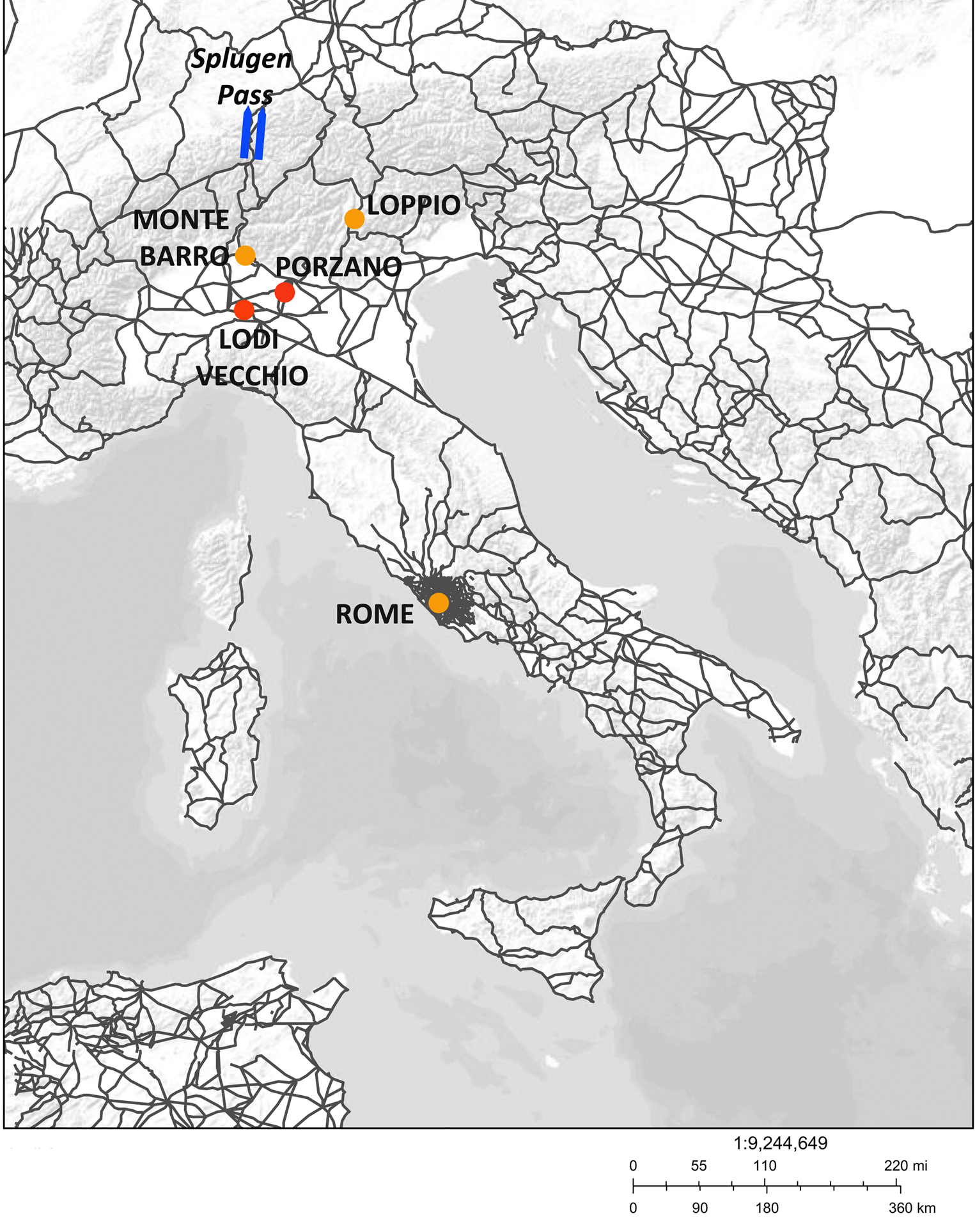
Cemeteries of the sixth–seventh century in the Po valley provide an interesting context for studying the dynamics of the circulation of garnets. From ad 568 onwards, the region became part of the first nucleus of the Lombard Kingdom, established by communities of migrants who settled in Italy (Brogiolo, Reference Brogiolo, Brogiolo, Marazzi and Giostra2017). This sector of the emerging kingdom occupied a region traversed by long-distance trade, which still ran along the former Roman road network (Knobloch, Reference Knobloch1998). Lombardy was a key area for the regulation of exchange between Italy and the transalpine region, as the Lombard rule controlled the Alpine passes (McCormick, Reference McCormick2001: 68), and Milan marked the starting point of the via Aurea, the road connecting the Po to the Rhine valley via the Splügen Pass (Knobloch, Reference Knobloch1998).
In this article, we present the results of the first chemical trace-element analysis of garnets from early medieval Italy, investigating jewellery and loose garnets from furnished burials from two sixth–seventh-century cemeteries in Lombardy. This is complemented by the analysis of glass gems and plaques for jewellery, to determine whether these glasses were made locally or were sourced from long-distance trade. Our results show that the current model of the garnet trade routes in early medieval Europe needs to be substantially revised and highlight the supra-regional character of a new elite that emerged in Italy during the Migration period.
The Cemetery of Campo Marchione in Leno and the Burials of Corte Bassa in Lodi Vecchio
The finds investigated for this study were selected from sixth–seventh-century female burials excavated in two Lombard sites: the large rural cemetery of Campo Marchione at Porzano in the commune of Leno (Giostra, Reference Giostra, Ebanista and Rotili2011, Reference Giostra and Giostra2017) and a small urban cemetery in Corte Bassa, in the south-eastern quarter of the Roman town of Laus Pompeia, now Lodi Vecchio (Jorio & Ferrucci, Reference Jorio, Ferrucci, Ciappi, Diani and Uboldi2017) (Figure 1). The cemetery of Campo Marchione was established in the last quarter of the sixth century, when the first generation of migrants settled in Italy, and remained in use until the end of the eighth century, when the site was abandoned (Giostra, Reference Giostra, Ebanista and Rotili2011, Reference Giostra and Giostra2017). The study of glass beads from the cemetery identified European products together with exotic specimens imported from Egypt and, to a minor extent, from India and Mesopotamia (Boschetti et al., Reference Boschetti, Gratuze and Schibille2020). Cloisonné garnet jewellery is documented in three exceptional female burials, two of which date to the end of the sixth century, and one to the first decades of the seventh (Giostra, Reference Giostra, Ebanista and Rotili2011: 258–59, Reference Giostra and Giostra2017: 85–86).
At Corte Bassa, four tombs clearly form a coherent group. Their location, close to a newly-founded church, the small number of burials, and the exceptional richness of the grave goods are characteristics observed elsewhere in Lombard Italy. Such small cemeteries were reserved for aristocratic families, as at Trezzo d'Adda (Ambrosioni & Lusuardi Siena, Reference Ambrosioni, Lusuardi Siena and Roffia1986) and Mantova (Facchinetti & Castagna, Reference Facchinetti, Castagna, Brogiolo, Marazzi and Giostra2017). Two of the four tombs, one of a girl (T US 61) and one of a woman (T US 6), as identified by anthropological analysis, stand out for the quantity and quality of their jewellery. The girl's grave was built in timber in line with German tradition and dates to the last quarter of the sixth century, while the brick structure of the woman's tomb and its stratigraphic position fits in the seventh century. Preliminary studies suggested that the tomb of the woman had been looted, because several garnets were found loose and were interpreted as gems left behind after the gold settings had been removed (Jorio & Ferrucci, Reference Jorio, Ferrucci, Ciappi, Diani and Uboldi2017: 162). However, one gold coin and several filigree-gold beads, with gold garnet-inlaid jewellery were still in situ, and we could ascertain that the loose garnets were instead a cache of finished and unfinished gems and wasters.
Materials and Methods
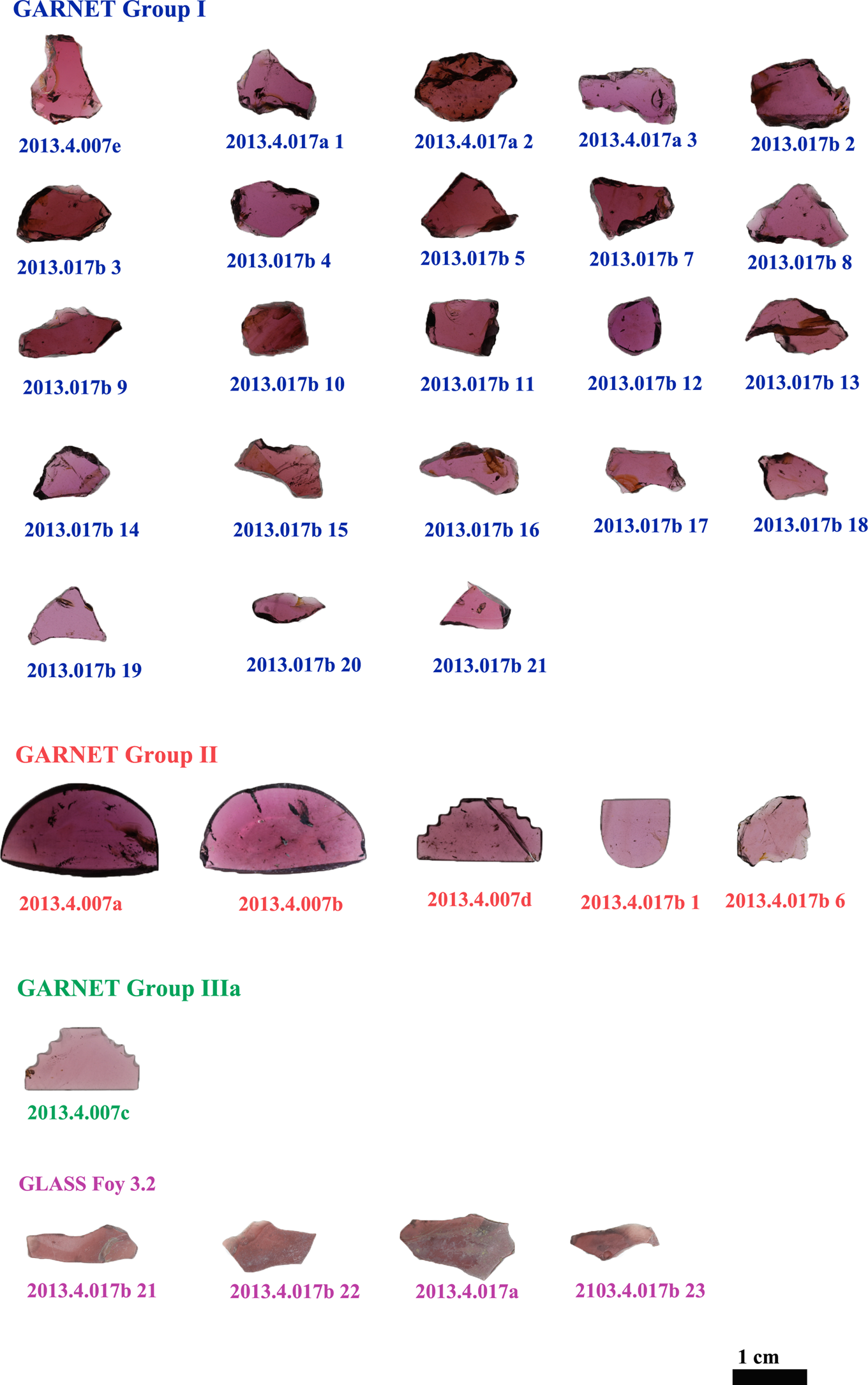
The objects presented here include all the jewellery inlaid with garnets from Campo Marchione and a selection of personal ornaments from Corte Bassa (Figures 2–3). Sixty-four garnets were analysed, both loose and set in jewels. The analysis also included four glass plaques, two cabochon gems, and four chips of translucent purple glass, deposited in the cache of loose garnets at Corte Bassa and erroneously identified as garnets before analysis.
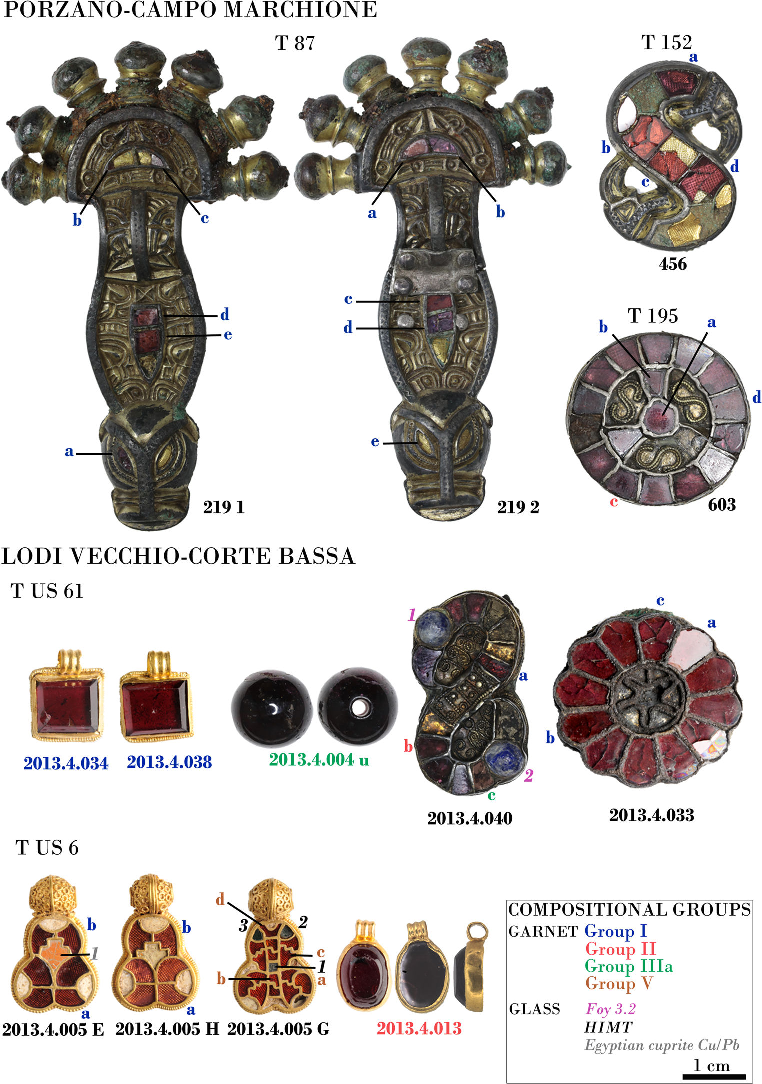
Jewellery from Campo Marchione-Porzano and Corte Bassa-Lodi Vecchio, with indication of tomb (T), sample number, garnet, and base glass type. Photographs by Cristina Boschetti reproduced with permission of the Soprintendenza Archeologia, Belle Arti e Paesaggio of the provinces of Bergamo and Brescia, and of Cremona, Lodi, and Mantova.
Loose garnets and glass chips from the tomb of a woman (T US 6) at Corte Bassa-Lodi Vecchio, divided into compositional groups. Photographs by Cristina Boschetti reproduced with permission of the Soprintendenza Archeologia, Belle Arti e Paesaggio of the provinces of Bergamo and Brescia, and of Cremona, Lodi, and Mantova.
All objects were investigated by optical microscopy, and compositional analyses were conducted at the Centre Ernest-Babelon of the CNRS Institut de Recherches sur les Archéomatériaux of Orléans using laser ablation inductively coupled plasma mass spectrometry (LA-ICP-MS). Details of the mass spectrometer used, ablation device, the procedure employed (e.g. Gratuze, Reference Gratuze, Dussubieux, Golitko and Gratuze2016), and the reference material used for calibration and verification are given in the online Supplementary Material together with relevant tables (Tables S1 and S2).
Results
Typology and style
The typology and context of the four cloisonné brooches from Campo Marchione (all artefacts are illustrated in Figure 2, as are those from Corte Bassa) date them to the end of the sixth century and suggest two different provenances. The pair of gilded silver bow fibulae with head ornamented with radiating onion-shaped knobs from Tomb 87 (nos. 219 1 and 2) and the S-shaped silver brooch with bird heads from Tomb 152 (no. 456) are related to examples from Cividale del Friuli, attributed to Italian workshops and dated to the end of the sixth century (Miazzo, Reference Miazzo1999; Ahumada Silva, Reference Ahumada Silva2012: 41). The disc brooch from Tomb 195 (no. 603), by contrast, is unique in Italy, showing similarities with small silver disc brooches documented in the Merovingian area and believed to be from workshops active in France (Giostra, Reference Giostra, Ebanista and Rotili2011: 262; Dalceggio, Reference Dalceggio2018: 116). The two brooches from the tomb of the girl of Corte Bassa (T US 61) can also be assigned to Merovingian workshops (Dalceggio, Reference Dalceggio2018: 14–17, with references). While the silver rosette (2013.4.033) belongs to a well-documented type, the gold S-shaped brooch (2013.4.040) has no exact parallels, but the same cloisonné work and the association of garnets with circular cabochon gems in translucent glass are well documented in Merovingian regions (Calligaro et al., Reference Calligaro, Périn, Vallet and Poirot2007: 137). No gold pendants with beaded frame inset with large garnets like those excavated in Corte Bassa (nos. 2013.4.034 and 38) are known from the Italian peninsula but similar gems with the same gold setting can be found in dozens of reused decorations of jewelled reliquaries, crosses, and book bindings from Lombardy attributed to local workshops active between the tenth and the twelfth centuries (Tomei, Reference Tomei1999; Bertelli & Stella, Reference Bertelli and Stella2001). Examples of pendants have been found in Saxon burials of the second half of the seventh century and are credited to Byzantine workshops active in the Italian peninsula (Crawford, Reference Crawford2004). The garnet bead (2013.4.004 u) was strung in a necklace with glass, calcedony, and rock crystal beads. Spherical garnet beads are documented in the sixth and seventh century in Lombard cemeteries, but knowledge of such artefacts is too limited to reconstruct their exact distribution and chronology (Giostra, Reference Giostra, Lusuardi Siena and Giostra2012: 269).
Unlike the jewellery from the tomb of the girl, the entire set of ornaments from the tomb of the woman (T US 6) can be attributed to Italian workshops. The absence of traditional brooches in this burial is consistent with changes in the style of personal ornaments documented in Italy in the seventh century (Giostra, Reference Giostra, Ebanista and Rotili2011; Micheletto et al., Reference Micheletto, Garanzini, Ugge, Giostra and Possenti2014: 18). The gold pendant inlaid with an oval garnet (2013.4.013) is clearly in Byzantine taste. The five cloisonné pendants, of which three are analysed in this study (2013.4.005E, H, and G), stand out for their high technical quality and are characterized by a combination of cloisonné on the body and filigree on the beads that form the suspension loop. Both the bodies and the beads are strikingly similar to gold jewellery attributed to workshops probably operating in Italy and deposited in burials dated between the end of the sixth century and the first decades of the seventh. The body of the pendants are similar to examples from Domagnano and Cividale (Brozzi, Reference Brozzi and Menis1990; Aimone, Reference Aimone2011), while the filigree beads are identical to those used in gold coin pendants from Nocera Umbra, Rome, and Klepsau (Koch, Reference Koch1990: tables 2, 9; Arslan, Reference Arslan, Ebanista and Rotili2011). The same filigree decoration with sections of gold threads forming minute circles is also employed in a series of disc brooches from Castel Trosino, Cividale del Friuli, Parma, and Isola Rizza (Verona) (Dalceggio, Reference Dalceggio, Beghelli and De Marchi2017, Reference Dalceggio2018: 135, 138–52, 156). Part of the assemblage from the woman's tomb at Corte Bassa, including loose chips of garnets and gems (Figure 3), were probably inside a casket, of which few fragments survive. While no garnet caches have thus far been recovered in Italy, several examples have been found in high-ranking female and, to a minor extent, male burials in southern Britain, Scandinavia, and Hungary (Horvath & Bendo, Reference Horvath and Bendo2011; Hamerow, Reference Hamerow, Hilgner, Greiff and Quast2017).
Lapidary and glass forming techniques
Members of the garnet family can be cut and polished using hard minerals, like diamond, corundum, and emery. Toolmarks on the surface of medieval gems suggest the use of rotating wheels coated with powdered emery or corundum and actioned by a lathe (Arrhenius, Reference Arrhenius1985: 55–58; Rifa-Abou El Nil & Calligaro, Reference Rifa-Abou El Nil, Calligaro, Beretta, Bromblet, Calligaro and Empereur2021), following a process described by Roman and medieval sources (Cannella, Reference Cannella2006: 262–84). The thin plaques used in cloisonné can be obtained either by heating the stone, which tends to fracture along its crystalline structure, or by incising guidelines with a wheel and snapping the gem (Arrhenius, Reference Arrhenius1985: 43–45). The loose unfinished garnets from the Lodi Vecchio cache vary from two to three millimetres in thickness and are partially polished on both sides. Part of the plaques are not perfectly flat near the edges, where the surface has in some cases the gritty texture left by the passage of a wheel. Lines traced by rotating tools are clearly visible and cross the surface of part of the plaques (Figure 4a, b). The edges are uneven and freshly fractured. These characteristics identify these garnets as wasters resulting from the last stages of shaping the cloisonné plaques, before proceeding to the final mirror polishing. By contrast, the loose garnets from the cache are carefully finished pieces, with convex surfaces, flat bases, and wheel-cut tapering borders (Figure 4c, d). The front is mirror-polished, and feather-shaped polishing lines are clearly visible under optical microscope (Figure 4d). Such lines are created by the repeated passages of a cloth with abrasive powder and water or, more conveniently, by using a damp wooden rotating wheel covered with abrasive powder (Arrhenius, Reference Arrhenius1985: 76).
Toolmarks and detail of lapidary work on loose and inset garnets, observed under optical microscope. A–B: lines left by the turning wheel and fresh fractures along the edges of garnet wasters; C: vertical polishing lines on the edges; D: feather polishing lines on the surface of finished loose gems; E–F: clean-cut edges of plaques set in cloisonné. Photographs by Cristina Boschetti reproduced with permission of the Soprintendenza Archeologia, Belle Arti e Paesaggio of the provinces of Bergamo and Brescia, and of Cremona, Lodi, and Mantova.

All the garnets set in cloisonné are flat, with wheel-cut facets running along the edges and mirror-polished surfaces. The shape of the plaques is always perfectly consistent with the design of the cloisonné (Figure 4e, f). A comparable technique was used for the two larger garnets set in the Lodi Vecchio square pendants (Figure 3). As for the oval pendant, its gem (Figure 2) is concave on the back, indicating that it was not cleaved by heating. Similar plain oval or circular stones have been identified as blanks for gem carving, imported to Europe from India as semi-finished gems during late antiquity and which remained in circulation for over a century (Adams, Reference Adams, Entwistle and Adams2011: 12–13). The garnet bead is spherical and carefully polished and was obtained by a combination of flaking, drilling, and polishing (Figure 2). Stone beads can be manufactured using a process still used in traditional agate bead-making in present-day India (Bhan et al., Reference Bhan, Kenoyer, Vidale and Kanungo2017).
The four purple glass plaques from the garnet cache are thin and flat on both sides (Figure 4). Similarly coloured glass plaques were used during late antiquity as inlays and were formed by pressing and tooling the hot glass on a marver (flat surface on which softened glass is rolled (Verità et al., Reference Verità, Maggetti, Saguì and Santopadre2013). The fresh fractures at the edges are the result of cold cutting, probably using a grozing iron (a type of pliers used to cut glass slabs). A similar process was presumably followed to obtain the plaques inlaid in the gold pendants. The cabochon blue gems set in the S-shaped brooch (2013.4.040) are the result of hot-working. A convenient procedure to form glass gems in a controlled way is to press a gob of soft glass into an open mould, as documented in Egyptian workshops making glass inlays during the Hellenistic and Roman period (Stern & Schlick-Nolte, Reference Stern and Schlick-Nolte1994: 49–50).
Chemical composition of the garnets and the glass
The minerals classified under the garnet family are aluminosilicates, displaying different crystal forms with a hardness on the Mohs scale between 6.5 and 7.5 (Muhling & Griffin, Reference Muhling and Griffin1991; Calligaro et al., Reference Calligaro, Périn, Vallet and Poirot2007: 115; Locock, Reference Locock2008). The colours of garnet vary significantly, from red-purple to orange-yellow, green and black, but the red-purple group is the only group documented in ancient jewellery (Arrhenius, Reference Arrhenius1985). All the garnets from Campo Marchione and Corte Bassa are red. The full analytical data of the sixty-four garnets are reported in Table S2 in the online Supplementary Material and illustrated in Figure 3. The garnets can be divided into five compositional groups (I to V) based on the concentrations of calcium, magnesium, yttrium, and chromium (Calligaro & Périn, Reference Calligaro and Périn2013, Reference Calligaro and Périn2019) (Figure 5a–c). Most of the garnets analysed in this study belong to Indian and Ceylonese garnet groups I, II, and IIIa. Group I garnets are the best represented (n = 49/64), followed by group II with eight exemplars (five loose garnets, one plaque from the S-shaped brooch from Corte Bassa, one from the disc brooch from Campo Marchione, and the oval garnet of the pendant from the tomb of the woman at Corte Bassa), and three of group IIIa (the bead and one plaque from the S-shaped brooch from the girl's tomb, and one loose garnet from the woman's tomb of Corte Bassa). Four garnets set in one of the cloisonné and filigree pendants from Corte Bassa (2013.4.005 H) are different and are consistent with Group V, which appeared around ad 600 and probably originates in the central mountains of Bohemia (Czech Republic) (Calligaro et al., Reference Calligaro, Périn, Vallet and Poirot2007).
Compositional groupings of the garnets (A–C) and glass samples (D). For the garnets, the ellipses are drawn according to Calligaro and Périn's (Reference Calligaro and Périn2013, Reference Calligaro and Périn2019) classification. Some differences between LA-ICP-MS and the method used to obtain the reference data (PIXE) may explain a slight shift between our data and the reference groups.
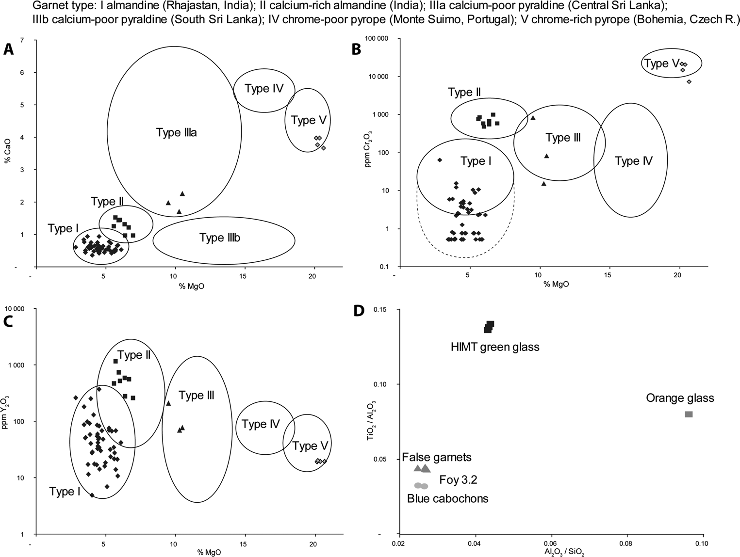
All the glass samples analysed are classified as natron glasses, according to their low (< 1.5 wt %) magnesium and potassium oxides (Sayre & Smith, Reference Sayre and Smith1961; Gratuze & Barrandon, Reference Gratuze and Barrandon1990; Shortland et al., Reference Shortland, Schachner, Freestone and Tite2006) (see Supplementary Material, Table S2, and Figure 3). It is well established that oxide ratios of Al2O3 to SiO2 and TiO2 to Al2O3 characterize the provenance and date of different natron base glasses (Freestone et al., Reference Freestone, Degryse, Lankton, Gratuze, Schneider, Rosenow, Phelps, Meek and Freestone2018). The two cabochon gems, and the four purple plaques from the garnet cache at Campo Bassa, have low aluminium, potassium, and titanium oxide contents and low to medium calcium oxide concentrations. They can be identified as a type known as Foy 3.2, a base glass produced in Egypt and dated mostly to the fourth to fifth century ad (Stojanović et al., Reference Stojanović, Šmit, Glumac and Mutić2015; Cholakova & Rehren, Reference Cholakova, Rehren, Rosenow, Phelps, Meek and Freestone2018; Balvanović & Šmit, Reference Balvanović and Šmit2020) (Figure 5d). The manganese content in four plaques is notably higher than in the typical Foy 3.2 composition, but this difference can be explained by an intentional addition of manganese, necessary to obtain a purple colour. The cobalt used for the two cabochons has a high CoO/NiO ratio (55.5), typical of cobalt sources used before the end of the fourth century ad (Gratuze et al., Reference Gratuze, Pactat and Schibille2018). The three translucent green plaques set in one of the gold pendants (2013.4.005 G), with high iron, manganese, and titanium oxides, belong to the late antique HIMT glass group, produced from the end of the fourth and during the fifth century in Egypt and popular across Europe (Freestone et al., Reference Freestone, Degryse, Lankton, Gratuze, Schneider, Rosenow, Phelps, Meek and Freestone2018). The orange glass set in the pendant 2013.4.005 E differs from the rest of the glasses analysed for its high lead and copper concentrations, which are often encountered in opaque orange glass (Schibille et al., Reference Schibille, Boschetti, de Juan Ares, Tévar and Veron2020, with references). Its high titanium and zirconium contents are in line with a possible Egyptian provenance.
Discussion
The typological and stylistic study revealed that the garnet-inlaid jewellery from the sites of Campo Marchione and Corte Bassa is a combination of products manufactured in different workshops located in the Italian peninsula and the Merovingian area. The diverse origins reflect the multiple directions of the circulation of finished jewellery that was traded, but also exchanged in the form of gifts and passed on as heirlooms (La Rocca, Reference La Rocca and Paroli1997; Barbiera, Reference Barbiera2012: 117–20; Hamerow, Reference Hamerow, Hilgner, Greiff and Quast2017: 71). This is compatible with the supra-regional character of the elites who ruled the Italian mainland between the sixth and seventh century. The South Asian provenance of the majority of the garnets is in line with the chronological trends observed in relation to medieval Europe more generally. The combination of South Asian and Bohemian garnets in the cloisonné gold pendants from Lodi Vecchio is particularly interesting, because European garnets were previously believed to have been used exclusively as cabochon gems, given that they were not suitable for cutting as cloisonné plaques (Calligaro et al., Reference Calligaro, Périn, Vallet and Poirot2007: 128). It is possible that highly specialized workshops continued to practise the cloisonné technique as late as the beginning of the seventh century, when the stocks of the larger South Asian garnets were running out.
The exclusive presence of Egyptian compositions in the glasses analysed in this study is significant, especially with respect to the Foy 3.2 group, which is extremely rare in Italy (Fiorentino et al., Reference Fiorentino, Chinni and Vandini2020). Foy 3.2 glass has been identified in Egyptian segmented beads retrieved from Merovingian burials (Gratuze, unpublished data), whereas it is not documented in wound beads manufactured in Europe, which are generally made with recycled Roman base glass (Boschetti et al., Reference Boschetti, Gratuze and Schibille2020, with references). Considering that Egypt was the major Mediterranean hub for the distribution of precious stones imported from southern Asia (Rifa-Abou El Nil & Calligaro, Reference Rifa-Abou El Nil, Calligaro, Beretta, Bromblet, Calligaro and Empereur2021), the Egyptian glass gems and plaques used in jewellery are most likely to be imports that travelled alongside precious stones. The presence of purple glass chips deposited with the garnet wasters from Corte Bassa can be explained by the fact that some fake stones, manufactured in Egypt, circulated with the stocks of garnets. The use of glass to forge garnet is described by Pliny the Elder (Pliny, Natural History 37, 25) and explains the presence of purple glass gems and plaques in cloisonné garnet jewellery from Saxon Britain (Bimson & Freestone, Reference Bimson, Freestone and Bimson2000) and Merovingian France (Calligaro et al., Reference Calligaro, Périn, Vallet and Poirot2007: 115).
The cache of South Asian finished garnets and wasters in the tomb of the woman at Lodi Vecchio is particularly telling for the role the Italian peninsula played in the long-distance garnet trade. This evidence indicates that exotic garnets were still circulating in Italy at the beginning of the seventh century. The peculiar deposition of loose garnets and wasters in British and Scandinavian burials is interpreted as a direct link between the deceased and the control of luxury goods exchanged through long-distance trade networks (Hamerow, Reference Hamerow, Hilgner, Greiff and Quast2017, with references). We know from anthropological evidence from lapidary workshops in present-day India that wasters are collected at the end of the work session and weighed to prevent the unauthorized sale of gems (Bhan et al., Reference Bhan, Kenoyer, Vidale and Kanungo2017). Wasters are not trade items and access to them implies a direct connection with the individuals who controlled the lapidary workshops and proximity with a centre where garnets were worked. It is therefore likely that the woman buried with the garnet cache was a member of a family directly involved in the circulation (and working) of precious stones.
The Lodi Vecchio garnet cache is unique in the Italian peninsula, but a similar interpretation can be proposed for the deposition of a block of raw amber in a female burial at Cividale at the end of the sixth century (Ahumada Silva, Reference Ahumada Silva2012: 37, 39, 47). Both sites are located along important long-distance routes. Cividale is close to the European terminal of the amber route that connected the Adriatic to the Baltic, while Lodi Vecchio is located on the Roman road passing Milan and leading across the Alps to reach the Rhine valley (Knobloch, Reference Knobloch1998). The Ostrogothic fort of Monte Barro, where garnets were worked during the first half of the sixth century, is located at the beginning of the Italian Alpine section of this route. The chemical characterization of the garnets from Monte Barro is not sufficiently clear to define their provenance, but the variations of their chromium concentrations indicate that they may belong to Asian groups II and III (Superchi et al., Reference Superchi, Muzzioli, Valisa, Brogiolo and Castelletti2001). If the presence of a lapidary workshop in Loppio is confirmed, it will add weight to the argument that the Alpine network of fortifications played a role in the long-distance trade of exotic products.
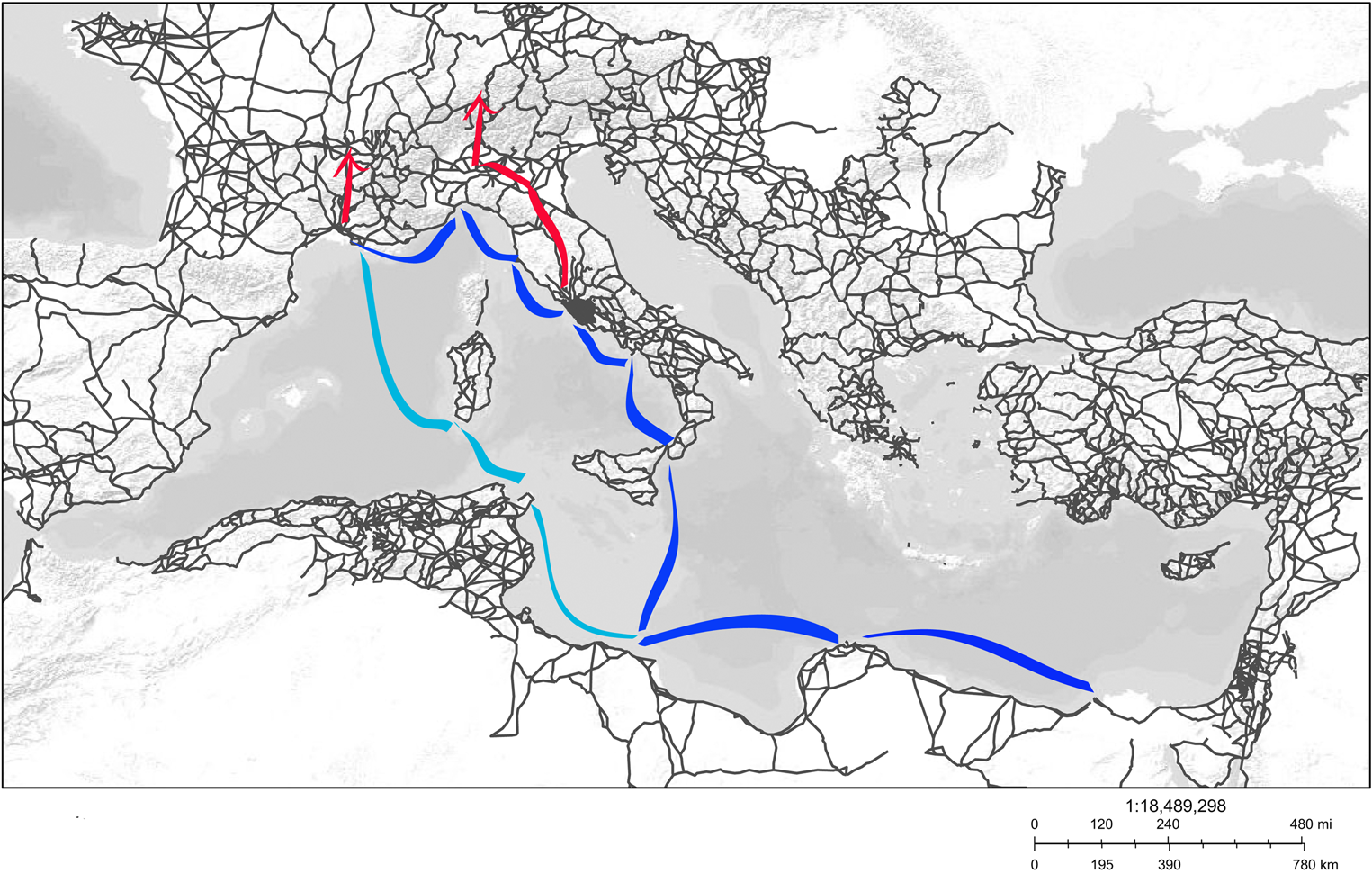
During the sixth century, both Monte Barro and Loppio were under Byzantine influence (Brogiolo, Reference Brogiolo and Daccò2008), and the Byzantines certainly controlled the commerce on the Alpine frontiers. The Crypta Balbi in Rome currently represents the southern limit of the Italian evidence for raw garnets. The available data are not sufficient to determine their provenance, but an emerald and a sapphire from the Crypta Balbi come from Egypt and Sri Lanka (or Burma), respectively, indicating that the workshop was handling exotic gems (Andreozzi et al., Reference Andreozzi, Graziani and Saguì1996). From the beginning of the seventh century, Rome was permanently integrated in the Byzantine administration (Delogu, Reference Delogu, Arena, Delogu, Paroli, Ricci, Saguì and Venditelli2001) and the identification of raw garnets and other exotic gems in the Crypta Balbi workshop attests to the Byzantine monopoly in the commerce of exotic products. Studies show that imports of oriental goods never ceased to reach Rome (Saguì, Reference Saguì2002), not even during the fifth and sixth centuries, traditionally considered a period of interrupted long-distance trade (Giannichedda et al., Reference Giannichedda, Mannoni, Ricci, Arena, Delogu, Paroli, Ricci, Sagu and Vendittelli2001). Egyptian wine continued to be imported via eastern Sicily, calling at the port of Syracuse before heading for Naples and then on to Marseille (Pieri, Reference Pieri, Rivet and Sciallano2002; Moncada, Reference Moncada2018). In light of these considerations, the previously accepted model of the garnet trade network can be modified, taking into account the key role of the Italian peninsula, where garnets arrived by sea and were traded further overland and along the Rhine corridor (Figure 6). The same path was probably followed by other South Asian and Egyptian goods used in jewellery, including glass beads (Pion & Gratuze, Reference Pion and Gratuze2016; Boschetti et al., Reference Boschetti, Gratuze and Schibille2020), gems and plaques, and cowrie shells (McCormick, Reference McCormick2001: 360). It is not surprising that all the nodes of this trade are in the territories controlled by the Byzantines, who held the monopoly over the circulation of exotic oriental imports and mastered the skills necessary to cut the precious stones.
Map of the Mediterranean showing the Roman road network and the eastern (blue) and western (light blue) sea routes connecting Alexandria to Marseille. In red, the terrestrial routes distributing garnets in Europe, starting in Rome and Marseille (adapted from the Digital Atlas for Roman and Medieval Civilizations).
Conclusions
During the early Middle Ages, the garnet route was more complex than previously thought. The Italian peninsula played a central role in this commerce, having direct access to Egyptian products via the sea and trading them across the Alpine roads. While the trade of finished jewellery followed circular movements, that of precious stones followed multiple branches but, until the beginning of the seventh century, its direction was predominantly from south to north. The routes of this commerce changed significantly when European garnets replaced South Asian imports. The lapidary workshops documented in Italy are in places under Byzantine control, and the trade in precious stones, including garnets, was most probably a Byzantine monopoly. When the Po valley became part of the Lombard Kingdom, the emerging Lombard nobility were undoubtedly instrumental in controlling the goods that came from the south and were directed north over the Alpine passes (McCormick, Reference McCormick2001: 68). We cannot identify the woman buried with the garnet wasters at Lodi Vecchio as a member of the Byzantine or Langobard aristocracy, but the location of her grave, in a Lombard town along a road crossed by long-distance trade, indicates how the different aristocratic groups living in the Langobard and Byzantine sectors of the peninsula participated in the trade and processing of exotic products. The deposition of finished garnets and wasters, previously documented in other European regions (Brownlee, Reference Brownlee2021) but now also in Italy, adds a new element to the cultural diversity and global identity of European society during the seventh century ad.
Acknowledgements
This project received funding from the European Research Council (ERC) under the European Union's Horizon 2020 programme (grant no. 647315 to Nadine Schibille). The funding organization had no influence in the study design, data collection, analysis, decision to publish, or preparation of the manuscript. We acknowledge the Soprintendenza Archeologia, Belle Arti e Paesaggio per le Province di Bergamo e Brescia, the Soprintendenza Archeologia, Belle Arti e Paesaggio per le Province di Cremona, Lodi e Mantova, and especially Gabriele Barucca, Andrea Breda, Cristina Longhi, Luca Rinaldi, and Simone Sestito for their kind assistance and for allowing us to study and publish the material.
Supplementary Material
To view supplementary material for this article, please visit https://doi.org/10.1017/eaa.2022.25.


 Open access