


INTRODUCTION
The heterogeneity and complexity of ancient Maya hinterland communities challenge the ways archaeologists have often conceptualized ancient rural areas. In the tradition of Western scholarship, Mayanists often use dichotomies, defining phenomena in relation to their opposites. For example, many scholars define ancient rural areas and the people who lived there by what they are not: urban (see Lamb Reference Lamb2022). Yet among the ancient Maya and other societies characterized by low-density urbanism (Fletcher Reference Fletcher2009), the distinction between the urban and rural is often ambiguous, as there is less of a density decline as one moves away from an urban center and the overall settlement density is relatively high (Iannone and Connell Reference Iannone, Connell, Iannone and Connell2003; Yaeger and Robin Reference Yaeger, Robin, Lohse and Valdez2004).
Contemporary Maya settlement pattern studies and household archaeology can trace their roots back to Willey's Barton Ramie project (Willey et al. Reference Willey, Bullard, Glass and Gifford1965). In the last two decades, however, scholars have applied several overlapping but distinct analytical frames in household and settlement archaeology, such as rurality and hinterlands, communities and neighborhoods, Maya commoners, and everyday life. We have certainly moved beyond the time when commoners were described as “people without history” (Lohse and Valdez Reference Lohse, Valdez, Lohse and Valdez2004:3). Yet despite the volume of recent studies, relatively few scholars have specifically targeted small-scale public locations in rural settlements for in-depth exploration (for exceptions, see Brown and Gerstle [2002], Gerhardt and Hammond [Reference Gerhardt, Hammond and Hammond1991], Hyde [Reference Hyde2011, Reference Hyde2014], Peuramaki-Brown [Reference Peuramaki-Brown2012, Reference Peuramaki-Brown2013], and Powis [Reference Powis1995]). While there is a relatively robust body of literature on rural sites usually called secondary centers or minor centers (Connell Reference Connell2000, Reference Connell, Iannone and Connell2003; Mixter and Henry Reference Mixter and Henry2017; Robin Reference Robin2013; Robin et al. Reference Robin, Blackmore and Latsch2005; Walden et al. Reference Walden, Ebert, Hoggarth, Montgomery and Awe2019; also see Valdez et al. Reference Valdez, Trachman and Cortes-Rincon2022), these sites are larger than the spaces discussed here. They presumably served as focal nodes for larger groups of people and played different roles in ancient social processes and dynamics than smaller focal nodes like the one discussed here.
In this article, we explore the dialectical relationship between hinterland and center as understood through SL-13, a small focal node in the hinterland settlement zone of San Lorenzo, Belize. This group was used and modified by the local community from the Preclassic to the Terminal Classic periods. Its proximity to the large centers of Xunantunich and Actuncan and the continual use of this space over centuries suggests that this group played an enduring role in the sociopolitical constitution of the San Lorenzo community and its integration into the region's larger polities.
We use the term focal node broadly to refer to spaces that were created to be centers of activity where people engaged in face-to-face interactions that included practices of affiliation (Hutson Reference Hutson2016; Peuramaki-Brown Reference Peuramaki-Brown2013; Yaeger Reference Yaeger2000a). Much like the term minor center (Iannone Reference Iannone and Garber2004), the term focal node embraces a wide range of variation. Hutson (Reference Hutson2016:80) notes that focal nodes can include local temples and shrines, the residences of neighborhood leaders who host neighborhood-wide events, and open spaces where people living nearby gather. This morphological and scalar variability are due in large part to the specific activities that occur in each focal node: they are as heterogeneous as the practices that occurred in them. They can be venues for both local, bottom-up and top-down sociopolitical strategies, and participants in any one event can include diverse social groups from the locality around the focal node, to those living at greater distance, including polity elite and rulers (Ball and Taschek Reference Ball and Taschek1991; Chase Reference Chase2016; Connell Reference Connell2000, Reference Connell, Iannone and Connell2003; Hutson Reference Hutson2016). The critical aspect is that these spaces foster face-to-face interaction that gives participants the opportunity to create and renew relationships, while negotiating and contesting key social constructs including shared identities and social differences (Lamb Reference Lamb, Hutson and Arden2020; Peuramaki-Brown Reference Peuramaki-Brown2013; Yaeger and Canuto Reference Yaeger, Canuto, Canuto and Yaeger2000).
The exploration of the places we refer to as focal nodes is nothing new in Maya archaeology. Over the past century, archaeologists have used a variety of models to define cities, sites, districts, and neighborhoods based on specific spatial parameters. Whether these are concentric models (Marcus Reference Marcus, Vogt and Leventhal1983), site typologies based on key architectural features (Adams and Jones Reference Adams and Jones1981), Thiessen polygons (Ball and Taschek Reference Ball and Taschek1991), or neighborhood analysis (Hutson and Welch Reference Hutson and Welch2019; Peuramaki-Brown Reference Peuramaki-Brown2014), many of these models share the underlying premise that humans organize themselves around focal nodes at various scales across the settlement hierarchy (Ashmore Reference Ashmore and Ashmore1981; Hutson Reference Hutson2016; Iannone Reference Iannone, Robertson, Seibert, Fernandez and Zender2006; Walden et al. Reference Walden, Ebert, Hoggarth, Montgomery and Awe2019). Indeed, the creation of focal nodes may have been the impetus for the subsequent establishment of the first sedentary villages in the Maya lowlands (Inomata et al. Reference Inomata, Triadan, Vázquez López, Fernandez-Diaz, Omori, Belén, Bauer, Hernández, Beach, Cagnato and Aoyama2020; also see Brown Reference Brown2001, Reference Brown2007; Brown and Garber Reference Brown, Garber, Stanton and Magnoni2008; Estrada-Belli Reference Estrada-Belli, Burger and Rosenswig2012; Garber et al. Reference Garber, Brown, Awe, Hartman and Garber2004; Hammond Reference Hammond1991; Healy et al. Reference Healy, Cheetham, Powis, Awe and Garber2004; Hyde Reference Hyde2011; Inomata Reference Inomata, Tsukamoto and Inomata2014; Inomata et al. Reference Inomata, Maclellan and Burham2015). While many scholars discuss the general importance of focal, public spaces in hinterland and rural communities, however, relatively few studies have specifically targeted small-scale focal nodes for in-depth exploration.
FOCAL NODES, PUBLIC SPACES, AND PRACTICES OF AFFILIATION
Focal nodes regularize social interactions, increasing the strength of social ties and impacting the ways rural communities are constituted and integrated into larger sociopolitical landscapes (Burham et al. Reference Burham, Inomata, Triadan, MacLellan, Houk, Arroyo and Powis2020; Lamb Reference Lamb, Hutson and Arden2020:322; Peuramaki-Brown Reference Peuramaki-Brown2013). Lamb (Reference Lamb, Hutson and Arden2020) distinguishes rural spaces from urban spaces by highlighting the high degree of social familiarity but lower “intensity” of face-to-face interactions in rural settings (also see Greenbaum Reference Greenbaum1982; Hipp and Perrin Reference Hipp and Perrin2009). That is, interactions with others may be less frequent in rural areas, but the chances of having an established relationship with those you encounter are higher than in a city.
Within rural communities, focal nodes serve as public spaces for regularized and formal interactions among community members, which are scripted in ways that casual encounters often are not. Often juxtaposed with domestic space, public space in Maya archaeology has been explored primarily within urban cores from a top-down perspective, focusing on the ways that the elite control or regulate activities within those particular spaces (Chase and Chase Reference Chase and Chase2004; Houk Reference Houk2015; Inomata et al. Reference Inomata, Maclellan and Burham2015; Lohse Reference Lohse, Gonlin and Lohse2007; Walden et al. Reference Walden, Ebert, Hoggarth, Montgomery and Awe2019). Yet within rural and hinterland settlements, we argue that the public spaces in focal nodes were critical to community and identity formation. While we see focal nodes as inherently integrative spaces, the nature of social ties being constituted and reproduced in those spaces could be quite variable, creating social cohesion while also reinforcing social differences. These small-scale focal nodes may be especially crucial to the integration of low-density urban societies. In the Maya lowlands, even small neighborhoods and rural settlements typically have an area designated for collective gatherings and activities (e.g., Connell Reference Connell, LeCount and Yaeger2010; Ingalls Reference Ingalls2017, Reference Ingalls2020; Kurnick Reference Kurnick2013).
As social groups create a built environment, buildings become embedded in social landscapes, serving as durable symbols of economic and symbolic investment and indicators of status, wealth, and power (Abrams Reference Abrams1989; Awe Reference Awe2008; Brown Reference Brown2008; Brown et al. Reference Brown, Lytle, Rawski, Ingalls and Villarreal2017; Burger and Rosenswig Reference Burger and Rosenswig2012; Houk Reference Houk2015; Lawrence and Low Reference Lawrence and Low1990; Lohse Reference Lohse, Gonlin and Lohse2007; Rosenswig and Burger Reference Rosenswig, Burger, Burger and Rosenswig2012; Trigger Reference Trigger1990). The symbolism of the space itself is an expression of identity that structures social rules and expectations of behavior with and within them (Bourdieu Reference Bourdieu1977; Lefebvre Reference Lefebvre1991; Mixter Reference Mixter2017a; Suttles Reference Suttles1972; Waterson Reference Waterson1990). Yet what likely made places important to the people who experienced them were practices that endowed spaces with social memories, sacred energies, and group histories (Hodder and Cessford Reference Hodder and Cessford2004; Ingalls Reference Ingalls2020; Inomata and Tsukamoto Reference Inomata, Tsukamoto, Tsukamoto and Inomata2014; Mixter Reference Mixter2017a; Overholtzer and Bolnick Reference Overholtzer and Bolnick2017). It is through repeated practices, often over generations, that communities throughout Mesoamerica established focal nodes as ritually and politically charged spaces.
The activities that took place in these spaces were as diverse and fluid as the social groups that hosted and participated in them. These activities included practices of affiliation: interactions that created and demonstrated links and social ties among participants and with others, whether present or not. The resulting affiliations could emphasize commonality and community, but they could also index hierarchical differentiation, and both simultaneously (Yaeger Reference Yaeger, Canuto and Yaeger2000b:131–136). In focusing on practices of affiliation, we must be mindful that these practices were not in fact equally accessible or integrative to all community members. Many events that reciprocally structured and enacted specific social relationships would likely have involved cross-sections of multiple communities. While the presence of certain individuals or factions may have dissuaded or disallowed others from participating in a given event, the long-term repetition of affiliative practices embedded and reproduced political structures, social memories, identities, and communities (Hodder and Cessford Reference Hodder and Cessford2004; Inomata and Tsukamoto Reference Inomata, Tsukamoto, Tsukamoto and Inomata2014; Isbell Reference Isbell, Canuto and Yaeger2000; Yaeger Reference Yaeger2000a). These repeated actions produced a shared local habitus, creating the community by structuring perceptions of self and other (Yaeger Reference Yaeger2000a:129).
Because practices of affiliation often involve the manipulation of economic resources and are set apart from daily household practice in terms of scale and frequency, ritual economy may be a useful lens to examine community interactions in public spaces. Ritual economy specifically ties material transfers to worldview, including the ways that practices of affiliation materialized ideology through rituals and ritualized processes (Barber and Joyce Reference Barber, Joyce, Wells and Davis-Salazar2007; McAnany and Wells Reference McAnany, Wells, Christian Wells and McAnany2012:1–2; Watanabe Reference Watanabe, Wells and Davis-Salazar2007). In a related vein, we argue that many events in rural focal nodes can be productively considered small-scale spectacles (Inomata and Coben Reference Inomata and Coben2006:16–17). Spectacles are typically public occasions that require the production and consolidation of resources, including labor, above the level of the household (Inomata and Coben Reference Inomata and Coben2006; Kovacevich Reference Kovacevich, Wells and Davis-Salazar2007; Stanish Reference Stanish, Feinman and Nicholas2004). They create social memories for participants and observers alike and are venues where relationships, identities, and ideologies can be reinforced, negotiated, or contested. Spectacles can take a variety of forms and often leave archaeological signatures, allowing us to tease out aspects of intra- and intercommunity interactions. As a result, these public ritual actions allow us to examine practices of affiliation and how these may (or may not) change over time.
SAN LORENZO, BELIZE
The ancient hinterland settlement of Rancho San Lorenzo sits on the eastern bank of the Mopan River in western Belize (Figure 1), approximately 1.6 km northeast of Xunantunich, and one km south of Actuncan (Figure 2). San Lorenzo is one of the most studied settlement zones in the Xunantunich hinterlands, with projects directed by Yaeger (Reference Yaeger2000a), Ingalls (Reference Ingalls2020), VandenBosch (Reference VandenBosch and Leventhal1992), Whitaker (Reference Whitaker2014), Lindley (Reference Lindley2016), and Villarreal (Reference Villarreal2018). Originally mapped as the Rancho San Lorenzo Survey Area by the Xunantunich Archaeological Project, this ancient hinterland settlement zone consists of five spatially discrete settlement clusters of domestic groups and a single ritual-administrative group (Figure 3). This latter group, SL-13, is located near the river and situated between two Late Classic settlement clusters (Yaeger Reference Yaeger2000a). SL-13 is not spatially embedded in any of the settlement clusters, suggesting it was a focal node for the broader area rather than for any single settlement cluster.
Belize Valley Region. Image courtesy of the Mopan Valley Preclassic Project/Mopan Valley Archaeology Project projects.

Light detection and ranging (LiDAR) image of San Lorenzo and surrounding sites. Image courtesy of the MVPP/MVAP projects.

Rancho San Lorenzo settlement zone with spatially discrete settlement clusters indicated. Image courtesy of the MVPP/MVAP projects.

Our analysis of SL-13 directly addresses the nature of rurality that is the topic of this special issue, but we prefer to use term hinterland to refer to San Lorenzo (also see Yaeger Reference Yaeger and Smith2003b). Many authors (Lamb Reference Lamb, Hutson and Arden2020; Yaeger Reference Yaeger and Smith2003b) have noted that rural implies a juxtaposition with the urban, as well as a very low settlement density relative to the city. Hinterland on the other hand denotes a distance from a center or major focal node (Hutson Reference Hutson2016), while often implying a dispersed settlement pattern associated with agriculture and small-scale craft production without major architectural features (Hyde Reference Hyde2014; Iannone and Connell Reference Iannone, Connell, Iannone and Connell2003; Lohse and Valdez Reference Lohse, Valdez, Lohse and Valdez2004; Schwartz and Falconer Reference Schwartz, Falconer, M. Schwartz and E. Falconer1994; Yaeger Reference Yaeger, Iannone and Connell2003a; Yaeger and Robin Reference Yaeger, Robin, Lohse and Valdez2004). Research in the Mopan River valley shows a relatively continuous settlement with no distinct drop-offs that clearly indicate the boundary of an urban area versus the surrounding rural settlement (Yaeger Reference Yaeger, LeCount and Yaeger2010). Lamb (Reference Lamb, Hutson and Arden2020:308) describes hinterlands as a city's “economic and social catchment area” and notes that this implies a top-down relationship of dependency and extraction. We argue, however, that this relationship of dependency does not necessarily follow; instead, we see hinterlands and centers as mutually constitutive (e.g., Yaeger Reference Yaeger2000a).
Research across the Rancho San Lorenzo settlement zone indicates that most houses were occupied during the Late Classic period, locally the Samal and Hats’ Chaak phases, a.d. 600–670 and a.d. 670–780 respectively (LeCount et al. Reference LeCount, Yaeger, Leventhal and Ashmore2002), but there is clear evidence of significant yet archaeologically ephemeral settlement beginning by ca. 1000 b.c. Donn (Reference Donn2018) found Cunil ceramics (1100–900 b.c.; Sullivan and Awe Reference Sullivan, Awe and Aimers2013) over three meters below ground surface in a geomorphology trench in the northwest sector of Rancho San Lorenzo, and a chultun in the San Lorenzo settlement cluster held a deposit of early Middle Preclassic (900–600 b.c.) ceramics (Villarreal Reference Villarreal2018; Whitaker Reference Whitaker2014). VandenBosch (Reference VandenBosch and Leventhal1992) discovered a buried Late Preclassic (300 b.c.–a.d. 300) structure on the floodplain near Donn's trench mentioned above. The Early Classic occupation is represented by several structures and deposits in the Floodplain North and San Lorenzo settlement clusters (Lindley Reference Lindley2016; Yaeger Reference Yaeger2000a).
To date, the San Lorenzo settlement cluster is best known (Yaeger Reference Yaeger2000a). Its first households were established in the Early Classic period, after which the community experienced rapid growth during the Late Classic Samal ceramic phase and reached its maximum size during the Hats’ Chaak phase. It then saw a decline leading to eventual abandonment in the Terminal Classic Tsak’ phase (a.d. 780–890). This trajectory mirrors that of the Late Classic rise and florescence of Xunantunich as a powerful regional polity and its Terminal Classic decline and abandonment (LeCount et al. Reference LeCount, Yaeger, Leventhal and Ashmore2002; LeCount and Yaeger Reference LeCount, Yaeger, LeCount and Yaeger2010a).
While the residential groups across the San Lorenzo zone exhibit a high degree of morphological variation, most are low cobble platforms that would have supported wattle-and-daub superstructures (Lindley Reference Lindley2016; Whitaker Reference Whitaker2014; Yaeger Reference Yaeger2000a). Some larger platforms were faced with limestone blocks, while the largest patio groups (SL-22, SL-23, and SL-24) had buildings with masonry walls, benches, and vaulted rooms (Robin et al. Reference Robin, Yaeger, Ashmore, LeCount and Yaeger2010; Yaeger Reference Yaeger2000a). These groups, located only 200–250 m from SL-13, appear to be the longest continually inhabited houses within the community and likely housed the community's most prestigious and politically connected families. In addition to the architectural differences, the people of these households also set themselves apart through hosting feasts and wearing exotic adornments of greenstone and marine shell (Yaeger Reference Yaeger2000a, Reference Yaeger, Iannone and Connell2003a).
Because of its location in an open space between two settlement clusters and its unique size and architectural features, we suggest that SL-13 (Figure 4) was the focal node for a broader San Lorenzo community that encompassed all of the Late Classic settlement clusters within the Rancho San Lorenzo settlement zone and perhaps beyond. The role of SL-13, however, predates the Late Classic: it was a center of political and ritual expression in the Late Preclassic and Early Classic periods as well (Ingalls Reference Ingalls2020; Yaeger Reference Yaeger2000a). The nature of those earlier communities, however, remains poorly understood due to the paucity of recovered domestic features from the Preclassic and Early Classic periods.
The SL-13 complex showing constituent structures. Image by Ingalls.

The structures and the practices enacted at SL-13 exhibit significant change over time, as multiple episodes of construction altered the complex's physical size and layout. Therefore, we examine SL-13 diachronically to assess long-term community political and economic dynamics, as well as the signification of community identity through time. Our ongoing research is specifically focused on identifying the structural and material changes at SL-13 that reflect the dialectical relationship between the community and the larger polities that rose and fell in the valley (Brown and Yaeger Reference Brown, Yaeger, Houk, Arroyo and Powis2020; LeCount et al. Reference LeCount, Yaeger, Cap, Simova, Canuto and St-Hilaire2022; Leventhal and Ashmore Reference Leventhal, Ashmore and Garber2004). Here, we describe the major architectural components of SL-13 and discuss how these may reflect the organization of the community and the shifting nature of authority and power over time. While we often distinguish ritual, political, and economic bases of power, these are entangled domains that cannot be examined in a vacuum. Thus, even as we see the public expressions of the local San Lorenzo community shift from more ritual to more political over time, the shift from one to the other does not mean that ritual was not a strong political force or that politics was devoid of ritual.
Our research shows that there are four major architectural phases at SL-13 that reveal the focal node's changing role within the local community. The first dates to the Late Preclassic (possibly slightly earlier), when a round platform, Structure 7, was built in an open ritual space with a thick marl floor. In the second phase during the Terminal Preclassic and Early Classic periods, Structure 7 and the associated marl surface were covered by the larger and rectilinear Structure 4 (specifically Structures 4-5th and 4-4th). The increased performative space on this structure's summit may indicate that larger spectacles and events were taking place here. The next major shift occurs during the Late Classic when the structures around North Patio were built, enclosing the plaster surfaced patio and restricting access to the formerly open space. The final phase dates to the end of the Late Classic and Terminal Classic periods and was marked by the burning of some structures and the excavation of a deep pit through Structure 4. We describe each in more detail below.
In the Late Preclassic, SL-13 consisted of an open patio or plaza surface and Structure 7 (Figure 5). In its final form, Structure 7 was 4.7 m in diameter and stood 55 cm tall. It lacked any evidence of a superstructure. Numerous parts of Structure 7 and the marl plaza floor surrounding it were burned, and there were several areas of smashed ceramics and other materials left on or embedded into the floor's surface. Although we never identified the edges of the marl surface, it covered an area of at least 8 × 10 m, suggesting it could accommodate relatively large groups of people. Charcoal samples collected from the marl surface returned two dates. The earliest dates to cal 385–181 b.c. ± 20 (calibrated at 2σ using OxCal v. 4.2.4 [Bronk Ramsey Reference Bronk Ramsey2001] and the IntCal13 atmospheric curve [Reimer et al. Reference Reimer, Bard, Bayliss, Beck, Blackwell, Ramsey, Buck, Cheng, Lawrence Edwards, Friedrich, Grootes, Guilderson, Haflidason, Hajdas, Hatte, Heaton, Hoffman, Hogg, Hughen, Felix Kaiser, Kromer, Manning, Niu, Reimer, Richards, Marian Scott, Southon, Staff, Turney and van der Plicht2013]). The second dates to 176–50 b.c. ± 20 (calibrated at 2σ). These dates suggest that this surface was used for an extended period during the first half of the Late Preclassic period, if not longer. Additionally, the multiple episodes of burning evidenced at this location suggest the long-term, repeated enactment of similar practices.
Photograph of SL-13 Structure 7 fully excavated, facing west. Photograph by Ingalls.
Structure 7 is similar to many other Preclassic round structures documented across the lowlands (Aimers et al. Reference Aimers, Powis and Awe2000; Hyde Reference Hyde2014; Peniche May Reference Peniche May2016; Powis Reference Powis1995; Powis et al. Reference Powis, Hohmann, Awe and Healy1996; also see Valdez et al. Reference Valdez, Trachman and Cortes-Rincon2022). These are typically low platforms measuring three to eight m in diameter and lacking superstructures, and they are often sites for later burials. Presenting a synthesis of known examples, Aimers and colleagues (Reference Aimers, Powis and Awe2000) argue that these open round structures were ceremonial platforms that served a local lineage (also see Hendon Reference Hendon2000; Peniche May Reference Peniche May2016). Open platforms “may be considered reflective of the less hierarchical, more charismatic, community-focused organization” of Maya society during the Preclassic (Aimers et al. Reference Aimers, Powis and Awe2000:82). In nearly all examples subjected to broader areal excavations, these round structures are closely associated with contemporaneous domestic buildings. In the case of Cahal Pech, Peniche May (Reference Peniche May2016) argues that emerging elite households hosted rituals in these structures that leveraged their differential access to valuable symbolic and material resources in order to increase and legitimize elevated sociopolitical status in the local community (Hendon Reference Hendon2000).
While the Late Preclassic community at San Lorenzo is admittedly poorly understood, we follow Peniche May (Reference Peniche May2016) to suggest that the emerging high-status households, perhaps living at SL-13 or nearby, created Structure 7 and the associated plaza space to host community rituals and practices of affiliation that reinforced and naturalized emerging hierarchical social relationships and economic inequalities in the community (also see Estrada-Belli Reference Estrada-Belli, Burger and Rosenswig2012). While provisioning and producing items for events held at this location, the host(s) would likely call on others within their social network to provide resources, labor, and materials. These liturgical economic exchanges would have created reciprocal bonds between the community members who shared in the benefits of a successfully completed ritual event, while also boosting the prestige and status of the host (Monaghan Reference Monaghan, Wells and McAnany2012). These ritualized activities would have had real-world results for the community, as they fulfilled reciprocal obligations with otherworldly forces. Additionally, these activities and spectacles would have facilitated and regularized the social interactions that created a local community.
On a larger scale, monumental centers like Early Xunantunich served similar purposes for emerging apical elite and early kings (Brown Reference Brown, Freidel, Chase, Dowd and Murdock2017). Normalizing and entrenching social hierarchies, the ritual practices and spectacles at Early Xunantunich established the ideological foundations for political complexity in the Mopan Valley (see Brown and Yaeger Reference Brown, Yaeger, Houk, Arroyo and Powis2020; Rawski Reference Rawski2020). These spectacles created larger imagined communities and formed enduring social memories (see Isbell Reference Isbell, Canuto and Yaeger2000; Yaeger Reference Yaeger and Smith2003b).
The next major architectural shift at SL-13 took place in the Terminal Preclassic and Early Classic when Structure 7 and the marl patio were covered by the larger and rectilinear Structures 4-5th and, subsequently, 4-4th. This alteration of space likely reflected a shift in the ritual and political needs of the San Lorenzo community. Whether Structures 4-5th and 4-4th were open platforms or supported perishable superstructures is unknown, although there is no clear evidence that currently points to the presence of a superstructure. Structure 4-5th was a low platform that was likely a venue for spectacle performances and events similar to the earlier Structure 7. Structures similar to Structures 4-5th and 4-4th with comparable histories have been interpreted as public ritual structures where divining and feasting occurred (e.g., Brown Reference Brown2001; Peuramaki-Brown Reference Peuramaki-Brown2013, Reference Peuramaki-Brown2014). The data outlined below support similar functions at SL-13.
In the center of Structure 4-5th, a stone-lined cist was cut into the structure's well-preserved floor and the interred individual dated directly to cal a.d. 180–338 ± 20 (calibrated at 2σ). This burial is especially interesting. During the Terminal Preclassic period, the burial of important ancestors becomes increasingly central to civic-ceremonial spectacles and political legitimation at larger centers in the region such as Early Xunantunich (Brown Reference Brown, Freidel, Chase, Dowd and Murdock2017; Brown and Yaeger Reference Brown, Yaeger, Houk, Arroyo and Powis2020; Lytle Reference Lytle2020; McAnany Reference McAnany2013). This particular individual may have been buried in SL-13 to establish this ancestor's place in the physical and spiritual center of the community, infusing the space with further spiritual energy and anchoring social memories around the burial and subsequent commemoration of this individual. Given that relatively few burials have been found in the Rancho San Lorenzo settlement zone to date, the number of individuals buried in the SL-13 complex suggests an enduring role for this complex as a place for venerating ancestors.
At the summit of Structure 4, just south of the cist, excavations uncovered a deposit of unifacially worked bladelets on the floor. This includes a grouping of 21 unifacially worked blade tools that were found in a dark, organic matrix potentially indicating they were part of a wooden grater board. In a detailed usewear and experimental archaeology analysis of similar unifacially worked bladelets from Early Xunantunich, Chapman (Reference Chapman2013; Chapman et al. Reference Chapman, Sword and Brown2015) showed that these tools were used to scrape soft materials like wood and gourds, or set in boards to grate tubers like manioc. Supporting this latter interpretation, Devio (Reference Devio2016) found starch grains from a variety of tubers, as well as other plants including chiles and corn, on the tools examined by Chapman. The small number of bladelets recovered at SL-13 contrasts with the thousands recovered at Early Xunantunich and at other sites, suggesting that the food processing was periodic and/or limited in scale. This is consistent with expectations of producing food for periodic feasts or particular rituals. Evidence of other productive activities and domestic refuse is not present during this period.
Feasting is a spectacle centered on the communal consumption and exchange of food and/or drink in specially constructed spaces (Clark and Blake Reference Clark, Blake, Brumfiel and Fox1994; Dahlin et al. Reference Dahlin, Bair, Beach, Moriarty, Terry, Staller and Carrasco2010:199; Dietler Reference Dietler, Dietler and Hayden2001:67; Dietler and Hayden Reference Dietler, Hayden, Dietler and Hayden2001). Beyond the production and consumption of foodstuffs, feasts are face-to-face practices of affiliation in which social relationships are created, negotiated, and maintained (Hayden Reference Hayden, Dietler and Hayden2001). They often evoke and reproduce both commensal identities such as community, while simultaneously indexing distinctions among the participants, as feasts present opportunities for individuals and social groups to mark differences by their differential contribution to the feast and by displaying visual symbols of their status (Brown Reference Brown2007; Brown and Freiwald Reference Brown, Freiwald and Arden2020). These symbols could take a variety of forms from specialized ceramic vessels with symbolic motifs to exotic adornments and inalienable objects. Inalienable objects notably include the animate remains of ancestors (Novotny Reference Novotny2014). Specialized and symbolic objects may be acquired or exchanged through ritual or political economies and may derive meaning in part from their source.
The next major shift at SL-13 occurs at the beginning of the Late Classic. With the construction of Structures 1, 2, 3, and 6 and the plastered North Patio they demarcate, the locus of ritual in SL-13 shifted from the South Patio to the North Patio. These structures enclosed previously open space, limiting access to the new patio to stairways that led up to Structures 2 and 3 and channeled movement through the buildings on their summits. This restriction in access to important spaces parallels the shift at Xunantunich towards more restricted access to major ceremonial buildings over time (Jamison Reference Jamison, LeCount and Yaeger2010; LeCount et al. Reference LeCount, Yaeger, Leventhal and Ashmore2002). During this period, Structure 4-2nd is remodeled into a square, raised platform on the east side of the South Patio platform, potentially supporting a perishable superstructure.
The Late Classic components of this ritual complex housed the remains of at least six individuals, including numerous children. The remains of children are especially intriguing, as they are infrequently found in ancestor shrines (Brown Reference Brown, Freidel, Chase, Dowd and Murdock2017; McAnany Reference McAnany2013). A comparable example, however, may come from the nearby site of Chan. The site's two pyramids, Structures 5 and 7, are distinct in form and larger in scale than the structures of SL-13, but they similarly served as the community's focal node from the Middle Preclassic through the Terminal Classic period (Robin et al. Reference Robin, Kosakowsky, Keller and Meierhoff2014). Robin and colleagues (Reference Robin, Kosakowsky, Keller and Meierhoff2014:383) argue that during the Classic period, interments in these shrines shifted from the veneration of individual ancestors to a more collective focus on the broader community, as indicated by the increased number of multiple interments and child burials. The similar shift in burial practices at SL-13 may indicate a comparable move to burial practices and rituals of commemoration that seek not to differentiate, but to reinforce membership in a larger social group.
The available data do not allow us to identify whether that social group was a particular segment of the larger community, such as a lineage group or a social group that encompassed or cross-cut lineage or other kin groups living in the community. Regardless, the South Patio became a prominent location for burials during this time, as more burials have been recovered in our excavations of this location than at any other excavated groups in the larger San Lorenzo community combined. Burial events are key times for the creation of social memories through various practices of affiliation when social bonds are called upon to mobilize and transfer various material and immaterial resources from one generation to the next. These ritual economic activities helped ensure the proper allocation of economic rights and obligations while simultaneously fulfilling the ritual-religious duties that ensured the proper transition of individuals through the liminal status of death. If these were more exclusionary rituals centered on a particular kin group, that group would have stronger ties, social memories, and potential claims to the ritual, political, and economic associations of SL-13. If SL-13 was a locus for burying people from across a broader community, interments could have created a communal space where both corporate and specialized/exclusionary events were performed. Likely critical for the long-term maintenance of a localized community identity, mortuary rituals embedded the memories of an individual into a broader shared narrative of the past. Thus, the group process of remembering and forgetting certain individuals was likely highly political and linked to understandings of what it means to be a member of the San Lorenzo community.
Several lines of evidence suggest that the South Patio continued to have a non-domestic function during this time (c.f. Yaeger Reference Yaeger2000a). Across the Mopan Valley and nearby at groups like SL-22 and SL-24 in the San Lorenzo settlement cluster, high-status residences consisted of tall platforms faced with cut limestone blocks supporting buildings with masonry walls and, often, corbelled masonry roofs. They also had interior benches with arm rests. Furthermore, they surrounded well-finished plastered patios. While SL-13 is the largest complex in the entire Rancho San Lorenzo survey area, the structures of the South Patio, including Structures 4-2nd and 4-1st, lacked cut limestone masonry, corbelled buildings, or benches. However, the South Patio itself lacked an extensive plaster floor. The substructures demarcating the North Patio are more consistent with our expectations of high-status architecture, but these platforms are longer and narrower than residential platforms excavated elsewhere in the region, and where we can reconstruct them, their footprints do not match that of domestic architecture. Yaeger (Reference Yaeger2000a) has argued that the architecture of the North Patio complex—including the highly restricted access to the patio, the stage-like qualities of the buildings, and an exterior plastered area north of Structure 1—all point to a non-domestic function. The artifacts he recovered included relatively high frequencies of incensarios and serving vessels, an unusual number of shell and greenstone adornments, a possible bone flute, and a high density of vertebrate faunal remains, which led him to argue this was an area for periodic gatherings, some of which entailed feasting.
We suggest that the South Patio had a complementary function, akin to Structure 10 at Joya de Cerén, as a specialized structure that housed ritual festival paraphernalia and the implements needed to prepare for and carry out feasts (Brown and Gerstle Reference Brown, Gerstle and Sheets2002). This interpretation is supported by the high frequency of small and well-used obsidian blades in the South Patio, a higher frequency of manos and metates than found in household contexts in San Lorenzo, and high frequencies of faunal and paleobotanical remains. Additionally, we recovered objects used for rituals, including divination, on and around the eastern Structure 4. These included clear quartz crystals, cave pearls, red ochre, iron ore mirror tesserae, and petrified wood (Ingalls Reference Ingalls2020). We continued to find ritual ceramic forms throughout the South Patio, including incensario fragments and drum sherds, although these were not as notable or numerous as Yaeger (Reference Yaeger2000a) found in the North Patio. Overall, the artifact assemblage recovered at SL-13 is remarkably similar to that of Buenavista del Cayo BVS-007, which Peuramaki-Brown (Reference Peuramaki-Brown2013) identifies as a community integrative feature (i.e., a focal node).
This phase of Late Classic construction coincides with Xunantunich's rise to political prominence in the valley (Brown and Yaeger Reference Brown, Yaeger, Houk, Arroyo and Powis2020; LeCount et al. Reference LeCount, Yaeger, Leventhal and Ashmore2002, Reference LeCount, Yaeger, Cap, Simova, Canuto and St-Hilaire2022). Yaeger (Reference Yaeger2000a) argued that the rulers of Xunantunich sponsored the construction of the North Patio buildings as part of their efforts to extend their authority over the surrounding hinterlands, creating a new, restricted space (the North Patio) where new practices of affiliation—feasts and other spectacles—could be undertaken. Given that the space is not large enough for all of the surrounding community's inhabitants, we see this restricted space as inherently diacritical in nature. Some spectacles likely included elite from Xunantunich, which would have emphasized the relationships between the polity's rulers and local community leaders, thus reinforcing the authority not only of the polity's rulers. The exterior space around SL-13 is (as far as we currently know) an open space that could have provided a venue where larger groups of community members could gather and witness parts of ritual performances on the summit or terraces of SL-13's structures. Gatherings could conceivably include communal feasting and other ritualized events, leading to the development of intracommunity social memories and identities. Thus, events in SL-13 would have simultaneously differentiated participants in open access areas from those within restricted, enclosed spaces—those on the interior of the North Patio from those on the exterior (also see Yaeger Reference Yaeger, Canuto and Yaeger2000b:358)—while symbolically involving both groups in the same larger spectacle and integrating the dispersed hinterland community.
Thus, changing the physical structures changed the ways individual community members accessed and interacted within the spaces of SL-13 and therefore the social memories anchored there. While this likely also affected the types and scales of specific practices enacted here, the enduring centrality of the place to the community's social, political, and religious life clearly continued. In this case, continued ritual and feasting activities suggest that the rulers at Xunantunich coopted a location that was already invested with social memories and community identity to engender loyalty and to normalize their rule. Additionally, sponsoring the reconstruction of a prestigious community space may have bought the new apical rulers enough goodwill to leverage (additional) labor and resources from the community. The rulers of Xunantunich likely incorporated existing community power structures while simultaneously reconfiguring them by creating connections between local leaders and the Xunantunich elite as a way to extend their reach and promote a stable and integrated low-density landscape (see Yaeger Reference Yaeger, Canuto and Yaeger2000b).
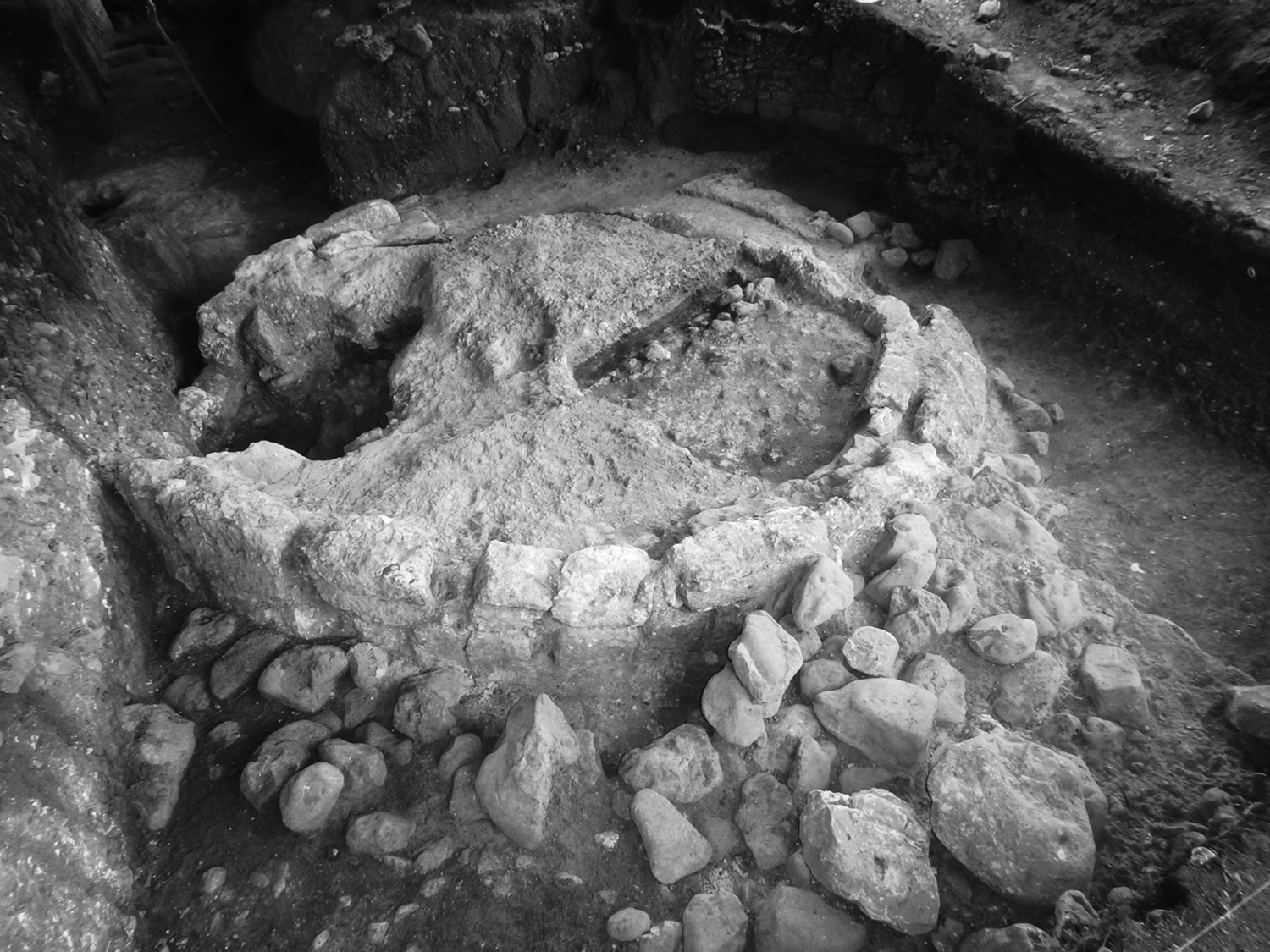
Finally, the Late Classic to Terminal Classic transition at SL-13 saw the ritual space desecrated or terminated by a large intrusive pit dug through the northwest corner of Structure 4 down through Structure 7 (Figure 6). The ceramic materials recovered from this intrusion indicate this event took place at the Late Classic to Terminal Classic transition, at roughly the same time that Structures 1 and 6 of the North Patio burned and collapsed. Similarly timed events are seen at Xunantunich and several small sites nearby (Yaeger Reference Yaeger, Canuto and Yaeger2000b), suggesting that this incident might have coincided with a larger regional phenomenon.
Structure 4 profile, showing intrusive pit and edge of Structure 7. Image by Ingalls.

While SL-13 continues to be used during the Terminal Classic Tsak’ phase, its function apparently changed. In the North Patio, there were no incensarios found in Terminal Classic deposits. Furthermore, the cobble constructions built on the South Patio during this period are very low and suggest minimal investment of labor and resources. Similar minimal investment in new buildings is further seen across the San Lorenzo settlement cluster during this period; polychrome and exotic materials disappear, suggesting a flattening of social hierarchies wherein social differentiation was less significant (Yaeger Reference Yaeger, Canuto and Yaeger2000b:360). These additional data points may suggest that the intrusive pit was meant as a desecration of the previously sacred space, possibly an attempt to ritually kill the building and potentially the ancestors associated with it (Stanton et al. Reference Stanton, Brown and Pagliaro2008). More broadly, Maya society in the Mopan Valley sees a reorganization beginning at the end of the Late Classic period, with the decline of divine kingship in the Terminal Classic period and a shift to shared, council-based governance at Actuncan (Mixter Reference Mixter2017a). The individuals most closely associated with SL-13 may have allied themselves too tightly with the rulers of Xunantunich and thus this focal node was impacted by the broader changes occurring during this period. As there is no evidence of Postclassic activity, SL-13 was likely completely abandoned by the end of the Terminal Classic.
Each of these major shifts at SL-13 mirrors notable transitions in Maya society more broadly as well as more local political trends. In periods with evidence of increasing social inequalities both within and between sites, community rituals were one way the changing social landscape could be normalized while maintaining a local identity through shared practices and social memories. By coming together to change the physicality of place and thereby reinterpret and regularize new forms of action, the hinterland communities engaged in practices of affiliation that entangled participants in economic, social, and political webs of interactions and processes.
DISCUSSION
Yaeger (Reference Yaeger2000a; Robin et al. Reference Robin, Yaeger, Ashmore, LeCount and Yaeger2010:332) has previously suggested that SL-13 was created though a top-down building regimen organized by the new Late Classic leaders of Xunantunich in a space disembedded from any of the area's settlements as a way to enmesh local leaders into the new political structures and political economy centered on Xunantunich. The documentation of a longer history of use and remodeling of this group described here show that SL-13 had a much longer and more complex history. Here, a brief understanding of the wider shifting politics of the valley is useful as we explore the strength of relationships and ties between the San Lorenzo community and the nearby political seats of power.
The Mopan River valley witnessed a succession of regional capitals that drew on different sources of authority and sequentially dominated the politics of the region (Figure 1; Brown and Yaeger Reference Brown, Yaeger, Houk, Arroyo and Powis2020; LeCount et al. Reference LeCount, Yaeger, Cap, Simova, Canuto and St-Hilaire2022). In the Middle Preclassic, Early Xunantunich (Figure 2; 800 m east of the Late Classic Xunantunich core) dominated the landscape with an E-Group complex and multiple plazas and monumental structures (Brown et al. Reference Brown, Lytle, Rawski, Ingalls and Villarreal2017). This center was an early focal node in an evolving ritual landscape, and the large plazas suggest sizeable imagined communities gathered here for various events, rituals, and spectacles. Early community leaders sponsored these monumental constructions and ritual performances to reinforce and legitimize a newly emerging social hierarchy, culminating in divine kingship by the end of the Late Preclassic period (Brown and Yaeger Reference Brown, Yaeger, Houk, Arroyo and Powis2020; Rawski Reference Rawski2020).
The decline of Early Xunantunich in the Terminal Preclassic (Brown Reference Brown, Freidel, Chase, Dowd and Murdock2017; Brown et al. Reference Brown, Lytle, Rawski, Ingalls and Villarreal2017) was followed by the rise of Actuncan, a large center located only two kilometers north of Xunantunich (Brown and Yaeger Reference Brown, Yaeger, Houk, Arroyo and Powis2020; LeCount et al. Reference LeCount, Yaeger, Cap, Simova, Canuto and St-Hilaire2022; McGovern Reference McGovern2004; Mixter Reference Mixter2017a). The presence of a triadic temple group, an E-Group complex, and a carved stone monument suggest that this site was the seat of an early kingdom (Mixter Reference Mixter2017a). The political power of Actuncan's ruler was eclipsed during the Early Classic (a.d. 250–600), and the seat of power in the valley moved farther north to Buenavista del Cayo (Ball and Taschek Reference Ball, Taschek and Garber2004; Brown and Yaeger Reference Brown, Yaeger, Houk, Arroyo and Powis2020; LeCount et al. Reference LeCount, Yaeger, Cap, Simova, Canuto and St-Hilaire2022; Yaeger et al. Reference Yaeger, Kathryn Brown, Helmke, Zender, Cap, Rodriguez and Batty2015). Similarly occupied from the Middle Preclassic to Terminal Classic, Buenavista saw its apogee during the Early Classic and early Late Classic periods when the population dramatically increased and many structures in the monumental center were constructed and renovated (Ball and Taschek Reference Ball, Taschek and Garber2004; Brown and Yaeger Reference Brown, Yaeger, Houk, Arroyo and Powis2020; Peurmaki-Brown Reference Peuramaki-Brown2012). Evidence of construction at the royal palace, hieroglyphic inscriptions, as well as Early Classic royal burials indicate that this site was established as the seat of a divine kingdom during the fifth century a.d., if not earlier (Yaeger et al. Reference Yaeger, Kathryn Brown, Helmke, Zender, Cap, Rodriguez and Batty2015, Reference Yaeger, Helmke, Brown, Zender, Cap and Freiwald2018). Like the preceding kingdoms of the valley, Buenavista's power was short-lived; during the Late Classic period, the center of power shifted back south to Xunantunich.
During the Samal phase (a.d. 600–670), the Classic Xunantunich center saw the establishment of a divine king and subsequent intense but brief consolidation of power, during which time Actuncan was likely a secondary center (Ashmore Reference Ashmore, J. LeCount and Yaeger2010; LeCount and Yaeger Reference LeCount, Yaeger, LeCount and Yaeger2010a). This rise to power was facilitated by direct ties to the larger kingdom of Naranjo (Brown and Yaeger Reference Brown, Yaeger, Houk, Arroyo and Powis2020; LeCount and Yaeger Reference LeCount and Yaeger2010b). During this period, the Castillo, palace complex, and other monumental structures were built in the epicenter, and populations in the surrounding hinterland settlements peaked. Yet by the end of the Late Classic, the city had begun to decline. While there are several monuments erected by Terminal Classic rulers, by approximately a.d. 850 civic construction had ceased and most of the epicenter and outlying hinterland settlements were abandoned (LeCount and Yaeger Reference LeCount, Yaeger, LeCount and Yaeger2010a).
While the entire region sees political decentralization and significant demographic decline during the Terminal Classic period (LeCount et al. Reference LeCount, Yaeger, Leventhal and Ashmore2002; Peuramaki-Brown Reference Peuramaki-Brown2014; Yaeger Reference Yaeger2000a), recent evidence suggests that Actuncan weathered this tumultuous period by rejecting the divine kings of previous periods and divine kingship itself, creating a new decentralized council-based political organization (Mixter Reference Mixter2017a, Reference Mixter2017b). The San Lorenzo community may have participated in this council-style organization, as evidenced by a Terminal Classic shell pendant carved with a council scene (Figure 7) and the relative lack of investment in public architecture. However, this system of governance also failed by the Postclassic (a.d. 1100–1500), when we find sparse evidence of regional occupation (Lindley Reference Lindley2016; Yaeger Reference Yaeger2008) and occasional visitation of sacred sites (Brown Reference Brown2011).
Engraved shell gorget showing Terminal Classic council scene. From Yaeger (Reference Yaeger, Canuto and Yaeger2000b:Figure VII.6).

These shifts in political power not only influenced the growth and development of the cities themselves, but also the surrounding hinterland and rural communities. Here, we may be able to expand our understanding of rural populations based on the level of local autonomy in governance as evidenced within public spaces. For example, communities with high levels of local control or autonomy are more likely to have wider networks and ties to multiple nodes within the network that allow them to weather dramatic political shifts within the region (Aimers and Iannone Reference Aimers, Iannone and Iannone2014; Isendahl and Smith Reference Isendahl and Smith2013; Turchin Reference Turchin2003). If communities develop a strong dependence on one major focal node, capital, or urban center, however, the community's resiliency is decreased as the system becomes more rigid and path-dependent.
We suggest that early in San Lorenzo's history, the community had wide social, political, and economic networks including Actuncan and Early Xunantunich that allowed certain flexibility and local autonomy. The substantial Early Classic construction of open, accessible ritually focused spaces at SL-13 along with the presence of exotic materials and communal feasting activities suggest that the San Lorenzo community had a high level of local autonomy and widely dispersed networks that helped the San Lorenzo community weather the broader political developments during this period while maintaining relatively constant access to resources, nonlocal materials, and labor.
Later, with the establishment of the Late Classic polity at Xunantunich, San Lorenzo came under more direct control of the new kingdom's rulers. This is evidenced through the changes both at SL-13 and nearby households in architectural form and the timing of these large construction events, an increased access to nonlocal resources, and a shift in the ritual practices enacted within SL-13 (Ingalls Reference Ingalls2020; Yaeger Reference Yaeger2000a). Additionally, the burial of numerous individuals within SL-13 during the Late Classic suggests that a prominent faction or lineage became the political elite of San Lorenzo, potentially acting as liaisons with the kings of Xunantunich. This hypothesis could be further tested through aDNA analysis to determine if the interred individuals are closely related. The strong and direct connections between San Lorenzo and Xunantunich in the Late Classic suggest that the level of interdependence was high. We suggest this dependency would have decreased San Lorenzo's resilience and ability to weather the turbulent Terminal Classic period, and the decline of Xunantunich corresponded with the abandonment of SL-13 and gradual depopulation of much of the surrounding community, although Lindley (Reference Lindley2016) has identified several loci of light Postclassic occupation.
San Lorenzo's history clearly demonstrates the complexity and dynamic nature of hinterland communities. To return to our opening discussion, the data gathered from SL-13 articulate well with the characteristics expected of focal nodes as integrative features within wider social landscapes. The practices of affiliation enacted within this space over time allowed the associated communities and groups to negotiate and display their status within the larger regional polities that formed and transformed throughout SL-13's history. Likewise, the shifts from corporate to more exclusionary spaces and activities over time not only reflected and normalized these changes taking place within the community, but they echoed broader social changes.
Exploration of the SL-13 group demonstrates that focal nodes can be used to understand the confluence of local and regional sociopolitical phenomena. Beyond structuring and anchoring a local habitus, the practices of affiliation enacted within this space become increasingly exclusive over time, reflecting broader social trends and likely increasing social differentiation within the local San Lorenzo community. As a focal node that was publicly legitimated by the community, local leaders or influential households may have tapped into the power of place, legitimizing themselves by their access to, control over, or affiliation with SL-13. It is also likely that during the Late Classic, rulers at Xunantunich leveraged local elites and the prestige of this focal node as a location through which their power could be created and enacted over the community. Additionally, practices of affiliation at SL-13 likely regulated aspects of economic exchange and obligation amongst members of the local community as well as with apical rulers at Xunantunich or Actuncan. Considering the many interments recovered throughout SL-13, this group may have functioned as an ancestor shrine of sorts. The individuals buried here were socially active beings whose ties to power and resources likely made them important anchors for the political and economic rights of the community (McAnany Reference McAnany2013).
Just as in all communities, rural communities are formed through shared experiences, social memories, and practices of affiliation, and it is at focal nodes where these practices and interactions are materialized most clearly in the archaeological record. Following Lamb (Reference Lamb, Hutson and Arden2020), if we focus on the intensity of social interactions as the defining feature of Maya rurality, then the exploration of public structures and focal nodes must be at the forefront of our inquiries. As this study shows, focal nodes within hinterland communities regularize and intensify interactions among members of the local community, as well as interactions with nonlocal individuals such as the elite of Xunantunich. SL-13 and its constituent structures were by no means monumental, yet they performed many of the same social roles that the larger focal nodes of surrounding sites of Actuncan and Xunantunich did. It was a place for community gathering, feasting, ritual performance and practice, and likely for political administration. Further exploration of focal nodes within hinterland and rural settlements will help us better understand the social histories of hinterland and rural communities.
RESUMEN
Las estructuras públicas en la región Maya materializan ideologías y definen centros de poder a medida que crean paisajes sagrados políticamente cargados. Estas ubicaciones son puntos nexos para los procesos de creación de la comunidad y la política, integrando jerarquías sociales, ideologías y recuerdos sociales en el paisaje físico. Sin embargo, los arqueólogos han centrado históricamente poca atención en los espacios públicos dentro de las comunidades rurales. Para explorar las formas en que las comunidades rurales o del interior pueden integrarse y articularse con los asientos de poder más grandes del corazón, este documento examina uno de esos grupos públicos en el sitio del interior de San Lorenzo, Belice. Los datos demuestran que este grupo fue utilizado y modificado por la comunidad local desde los períodos Preclásico hasta el clásico terminal. Su proximidad al gran centro de Xunantunich y el uso continuo de este espacio durante siglos sugiere que este lugar público desempeñó un papel duradero en la integración sociopolítica de la comunidad de San Lorenzo y la comunidad de Xunantunich. Los hogares y las comunidades en toda la región del valle del río Mopan y Belice tuvieron respuestas únicas a la dinámica política regional y las maniobras de los grandes centros políticos. Para comprender mejor la longevidad de la comunidad de San Lorenzo dentro de esta región dinámica, examinamos SL-13 para demostrar la compleja historia de integración de la comunidad como se ve en un espacio público focal. Las comunidades rurales se forman a través de experiencias compartidas, recuerdos sociales y prácticas de afiliación. Es en los nodos focales y espacios públicos donde estas prácticas e interacciones se materializan más claramente en el registro arqueológico. Como se ve en la heterogeneidad de San Lorenzo, las poblaciones rurales tienen élites, son rituales y económicamente creativas y diversas, y construyen espacios sociales, comunidades e identidades de la misma manera que lo hacen los humanos en cualquier patrón de asentamiento. Sugerimos que los académicos continúen enfocándose en las personas cuyas vidas fueron representadas dentro de estos espacios, y continúen abordando los agujeros en la literatura que nos permiten ver la extensión de la historia a través de un agujero ligeramente más grande.
ACKNOWLEDGMENTS
We sincerely thank the Institute of Archaeology, National Institute of Culture and History, Belize for their permission to conduct excavations and research at San Lorenzo. Investigations at San Lorenzo were made possible by the support of the Mopan Valley Preclassic Project (MVPP) and the Mopan Valley Archaeological Project (MVAP), the Alphawood Foundation, Ben and Trudy Termini, and the Department of Anthropology of the University of Texas at San Antonio. Additionally, this research would not have been possible without the contributions of the people of Succotz, Belize, especially the Juan and Xix families who graciously granted permission to work and excavate on their land. We would also like to thank the MVPP/MVAP project staff and field school students who contributed time, knowledge, and labor to this endeavor. Additional thanks to the reviewers for their valuable comments and suggestions.


 Open access