
North of the Antonine Wall
Highland
(1) Cromarty (NH 87 77): an unusual silver headstud brooch was recoveredFootnote 4 as a stray find. Both headstud and foot have circular insets of yellow glass inlaid with rows of a second colour in triangles, now lost (Fig. 1). The head and wings snapped at a casting flaw.Footnote 5
Silver headstud brooch variant, Cromarty (Crown copyright).

Perth and Kinross
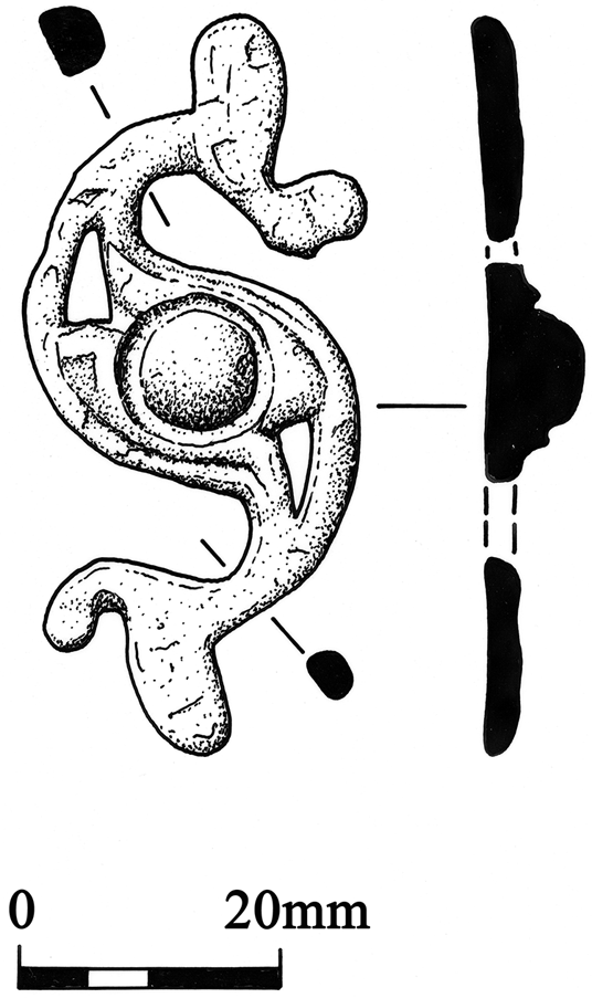
(1) Shanzie (NO 28 50): a worn but impressive openwork dragonesque brooch was found by metal-detecting in an area of known Iron Age activity (Fig. 2).Footnote 6
Copper-alloy dragonesque brooch, Shanzie (© Alan Braby/National Museums Scotland).

The Antonine Wall
Falkirk
(1) Mumrills, 34 Polmont Rd (NS 9162 7940): extension of a previous trench uncovered more of a large aisled building within the fort annexe. It was aligned north–south, at least 7 m long, and had been deliberately demolished. An underlying structural phase is argued to represent internal buildings of the first-phase fort.Footnote 7 A small pottery assemblage and a copper-alloy vessel escutcheon were recovered.Footnote 8
South of the Antonine Wall
South Lanarkshire
(1) Crawford, Viaduct Plantation (NS 9478 2131): slight earthworks of two temporary camps set on a broad terrace north of the river Clyde and about 400 m west of Crawford fort were revealed by visualisations derived from Airborne Laser Scanning data (Fig. 3). Both are truncated on the south side by river erosion. The larger camp is polygonal in plan, its long axis east–west with an angle in the north side. About 100 m west of the north-west corner is an entrance gap protected by a traverse. A second entrance would be anticipated in this side, though no trace can be detected; likewise no entrances are visible in the surviving east and west sides. The camp is c. 380 m east–west by c. 150 m transversely as it survives.
Airborne Laser Scanning data-derived Local Dominance visualisation of the camps at Crawford (LiDAR for Scotland Phase IV. Contains public sector information licensed under the Open Government Licence v3.0).

The smaller camp lies within the larger, occupying the western two-thirds of its interior. It has a playing-card plan, though the whole south side and adjacent corners are lost to erosion. It is on a slightly different alignment to the larger one. No entrances can be identified with confidence. The preservation of upstanding earthworks of the inner camp within the larger may suggests that it is later. The field to the east reveals a possible stretch of the road extending from the entrance of the fort. There are indications that the larger camp overlies the road.Footnote 9
Midlothian
(1) Pathhead (NT 41 62): metal-detecting recovered an interesting scatter of finds: an unusual enamelled brooch, an enamelled Roman Iron Age pommel cap, and a denarius of Marcus Aurelius. The brooch has a trumpet-like head with raised decoration and an enamelled flat bow.Footnote 10
East Lothian
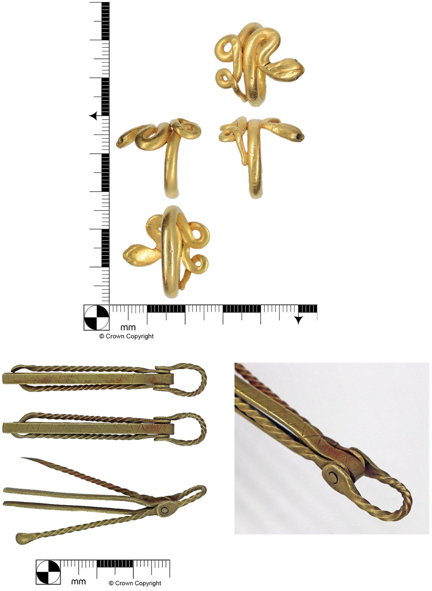
(1) Longniddry (NT 43 76): a scatter of objects found by metal-detecting in a watery area are likely to represent a series of offerings. Most striking is a gold snake-headed ring (type Aii); a toilet set and a complete type A3 penannular brooch were also recovered (Fig. 4).Footnote 11
Gold snake-headed ring (above) and copper-alloy toilet set (below), Longniddry (Crown copyright).

Scottish Borders
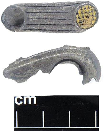
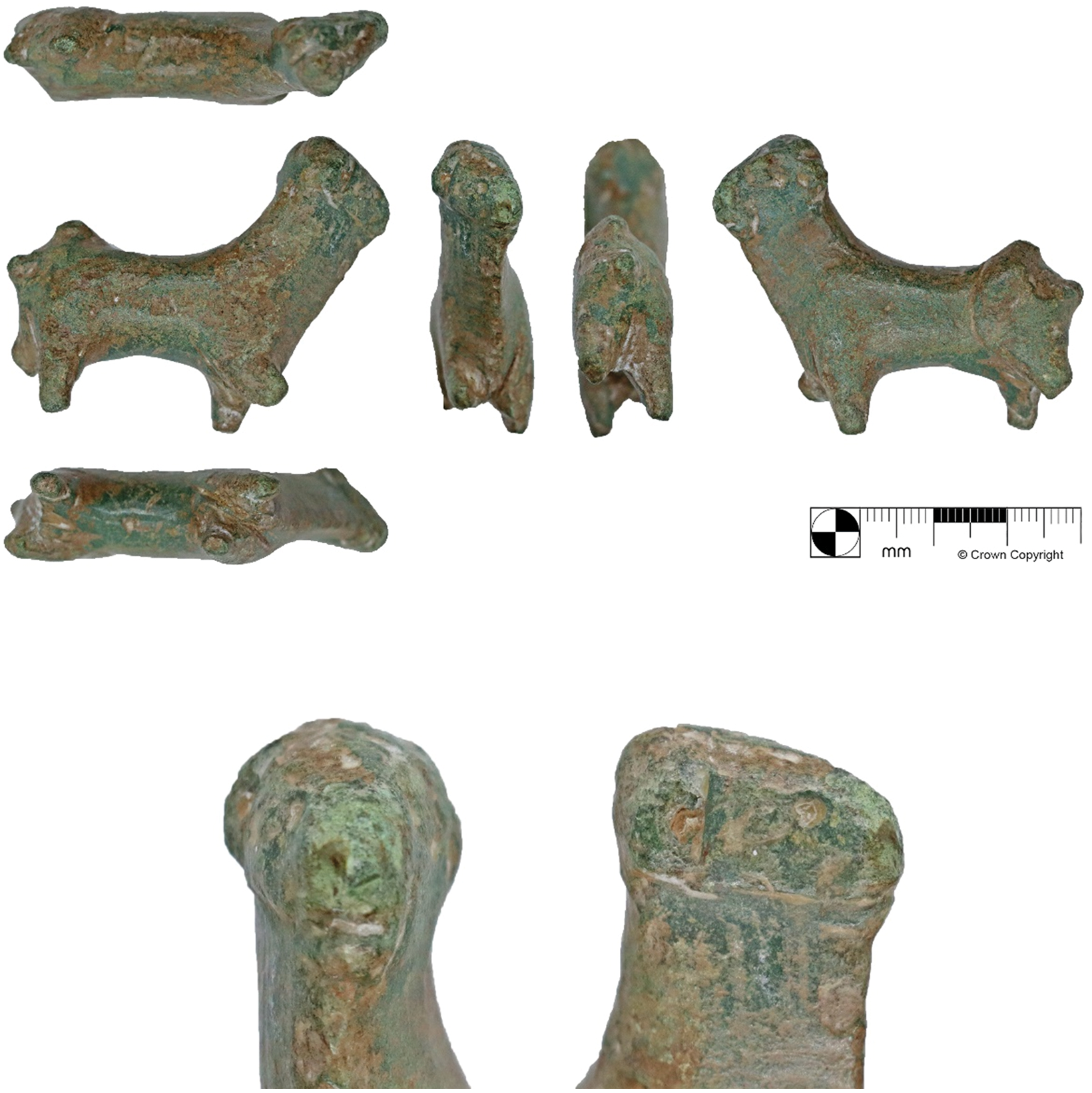
(1) Gattonside (NT 53 35): metal-detecting find of a copper-alloy bull statuette, head slightly turned to the left, its limbs, tail and any horns lost (Fig. 5).Footnote 12
Copper-alloy bull statuette, Gattonside (Crown copyright).

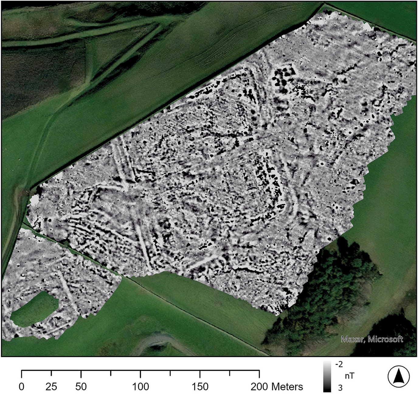
(2) Easter Happrew (NT 195 401): a magnetometer survey and more limited resistivity survey undertaken over the Flavian fort and its environsFootnote 13 revealed details of the fort’s internal structure and external activity to east and west on the plateau (Fig. 6).Footnote 14
Provisional results of the gradiometry survey over the fort at Easter Happrew (By courtesy of AOC Archaeology).

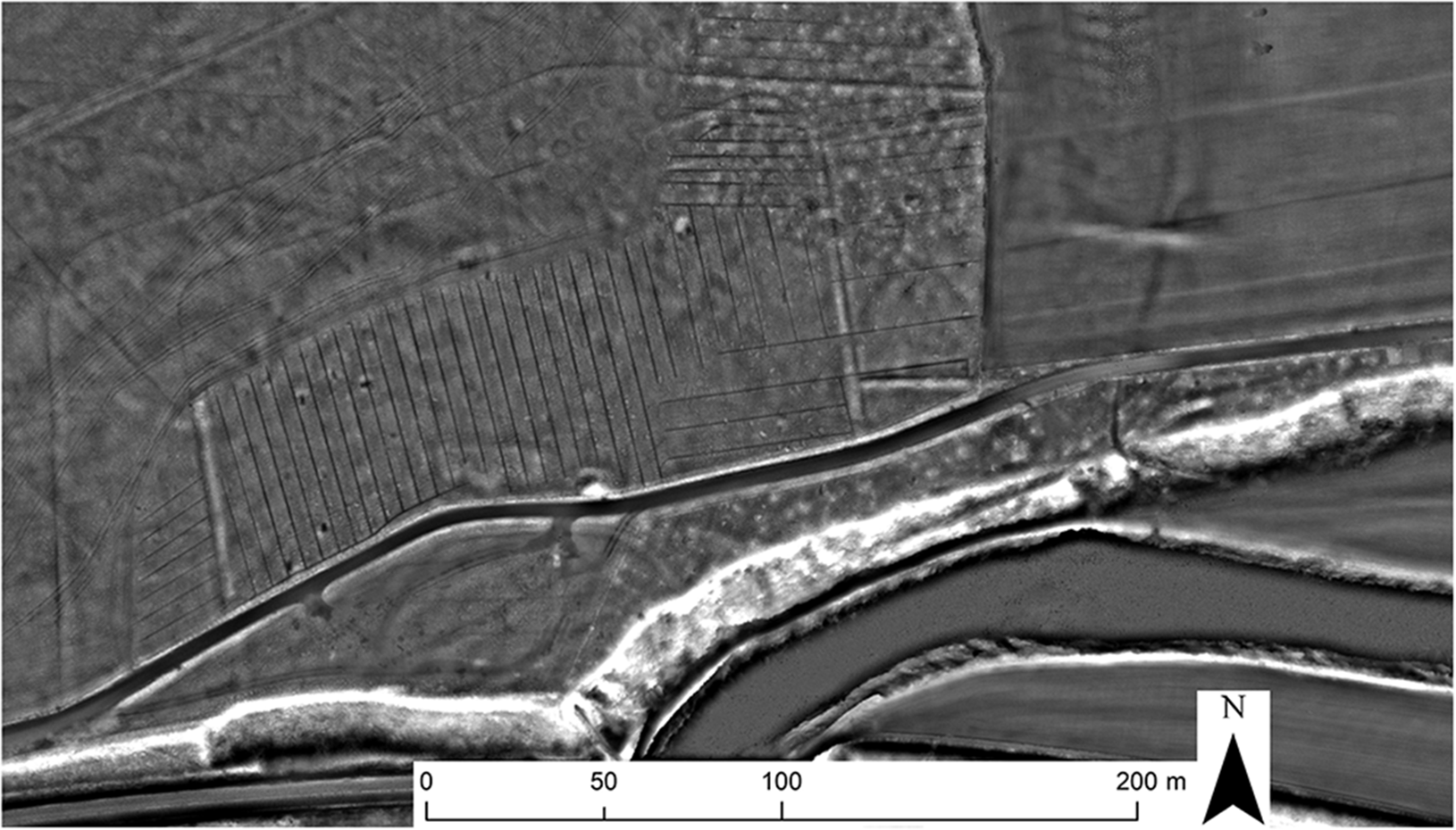
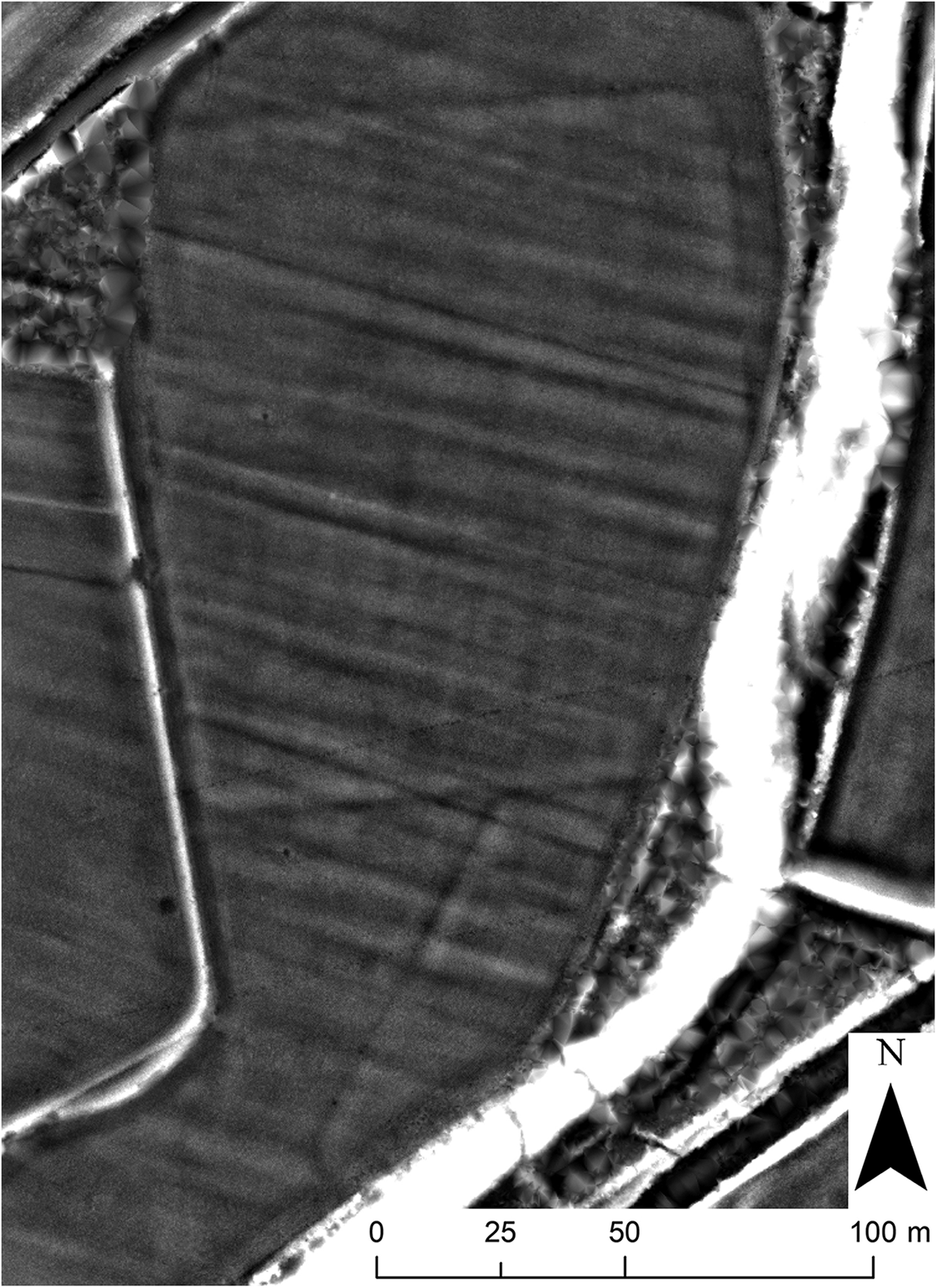
(3) Teviothead (NT 40305 04975): scrutiny of airborne laser scanning data revealed slight earthworks of two temporary camps on a terrace immediately to the west of the Frostlie Burn some 500 m south of its confluence with the river Teviot (Fig. 7). The playing-card outline of the larger and more complete camp gives internal dimensions of c. 130 m by 115 m;Footnote 15 the WSW side is obscured by a later field boundary and plantation, and the south-east corner is truncated by erosion. Indistinct gaps in the NNW and SSE sides may be gates, the former with a possible traverse. The second camp,Footnote 16 lying immediately to the south, has been heavily truncated by river erosion, but the WNW side survives in its entirety with the corners evident, giving an internal length of about 80 m. Their relative positions suggest the camps did not coexist.Footnote 17
Airborne Laser Scanning data-derived Local Dominance visualisation of the camps at Teviothead, accentuating their low banks and ditches against the ‘noise’ of later ridge and furrow. The white band running north to south represents a steep river terrace on the flood plain edge (LiDAR for Scotland Phase IV. Contains public sector information licensed under the Open Government Licence v3.0).

Supplementary material
For supplementary material for this article, please visit https://doi.org/10.1017/S0068113X25100512


 Open access