


Introduction
The Roman fort at Ambleside (Lake District, Cumbria, north-west England) is situated on the northern shoreline of Lake Windermere, in a position that today renders this installation one of the most scenically attractive in the British Isles (Fig. 1). It is, however, reasonable to assume that aesthetics was not an imperative for the Roman army when it built the fort amidst potentially hostile hills and maintained a garrison there from probably the late first century a.d. to the fourth century a.d. In the Roman period, the site was located in a strategic position guarding the road that went from the fort of Brougham near Penrith to the port of Ravenglass on the Cumbrian coast, passing other important locations such as the fort of Hardknott.Footnote 1
Ambleside Roman fort and Lake Windermere looking south. (Image: Trimontium Trust).

Fig. 1 Long description
An aerial view shows the Ambleside Roman fort located near the northern shoreline of Lake Windermere. The fort is situated amidst lush green fields with a clear layout visible. In the background, Lake Windermere is seen with several boats anchored near the shore. The surrounding landscape includes rolling hills and dense greenery, contributing to the scenic beauty of the area. A road is visible on the left, leading towards a small settlement near the lake.
Traditionally, Ambleside Roman fort has been identified with the site of Galava, mentioned in the Antonine Itinerary, although a link with Clanoventa has also been suggested.Footnote 2 The fort itself covered an area of c. 1.2 ha on a relatively marshy plateau with a number of rocky outcrops. In addition, there is evidence for a relatively large extramural settlement that extended to the northeast. In terms of occupation sequence, the first fort seems to have been built of turf and timber in the late first century a.d. Some decades later, probably in the reign of Emperor Hadrian, the fort was rebuilt in stone. These are the excavated remains that visitors can currently see at the site, including parts of the ramparts, gates, granaries, headquarters and the commander’s residence. Unfortunately, no unit inscriptions that might identify the garrison have been found so far, but the fort plan would suggest a 500-strong auxiliary cohort.
While the fort had been recognised as a Roman installation for a long time, the first systematic investigations were carried out by the two prominent Oxford scholars F.J. Haverfield and R.G. Collingwood in the second decade of the twentieth century. Their fieldwork was written up almost immediately and published over successive volumes of the Transactions of the Cumberland and Westmorland Antiquarian and Archaeological Society.Footnote 3 In the preface to the first paper, Haverfield drew the allusion of the fort’s remote position being a Roman parallel of an imperial outpost in northern British India.Footnote 4 Subsequent work at the fort and/or its environs was carried out by archaeologists such as M.E. Burkett,Footnote 5 R.H. LeechFootnote 6 and D. Drury et al. Footnote 7 over the course of the second half of the twentieth century. To this we need to add various watching briefs by Oxford Archaeology North in the early twenty-first century.Footnote 8
Although overlooked by the potentially threatening mountains of the Lake District, the fort lies in a reasonably strong defensive position, being surrounded on two sides by water (providing easy egress to the lake to the south). It can only be satisfactorily approached on foot along relatively narrow corridors of solid land to the north and east. The fort’s wider strategic context, lying as it does almost equidistant from the even more remote Hardknott to the west and Brougham to the northeast, makes sense in terms of local command and control. Due to its location at the intersection of various communication routes, Ambleside could have acted as a regional Roman supply-base that would also have benefited from the transport of goods by boat through Lake Windermere.
Conflict at Ambleside? Previous evidence and new research
Over the years, a number of Roman lead sling bullets (glandes) have been found at the fort and its environs (Fig. 2). As is generally recognised within battlefield archaeology research, a high concentration of sling bullets at the same location can suggest a storage place, but a wide scatter of finds is more likely to signify a conflict scenario. Although some bullets can be found in clusters beside or within forts, such as at VindolandaFootnote 9 or Strageath,Footnote 10 wide scatters outwith Roman military structures are rare and point to evidence of conflict, such as the glandes from Windridge Farm near St Albans,Footnote 11 or the scatter of lead bullets outside the Roman fort of Velsen in the Netherlands.Footnote 12
Location plan of Ambleside fort and find spots of sling bullets uncovered prior to our new fieldwork. (Image: Trimontium Trust).
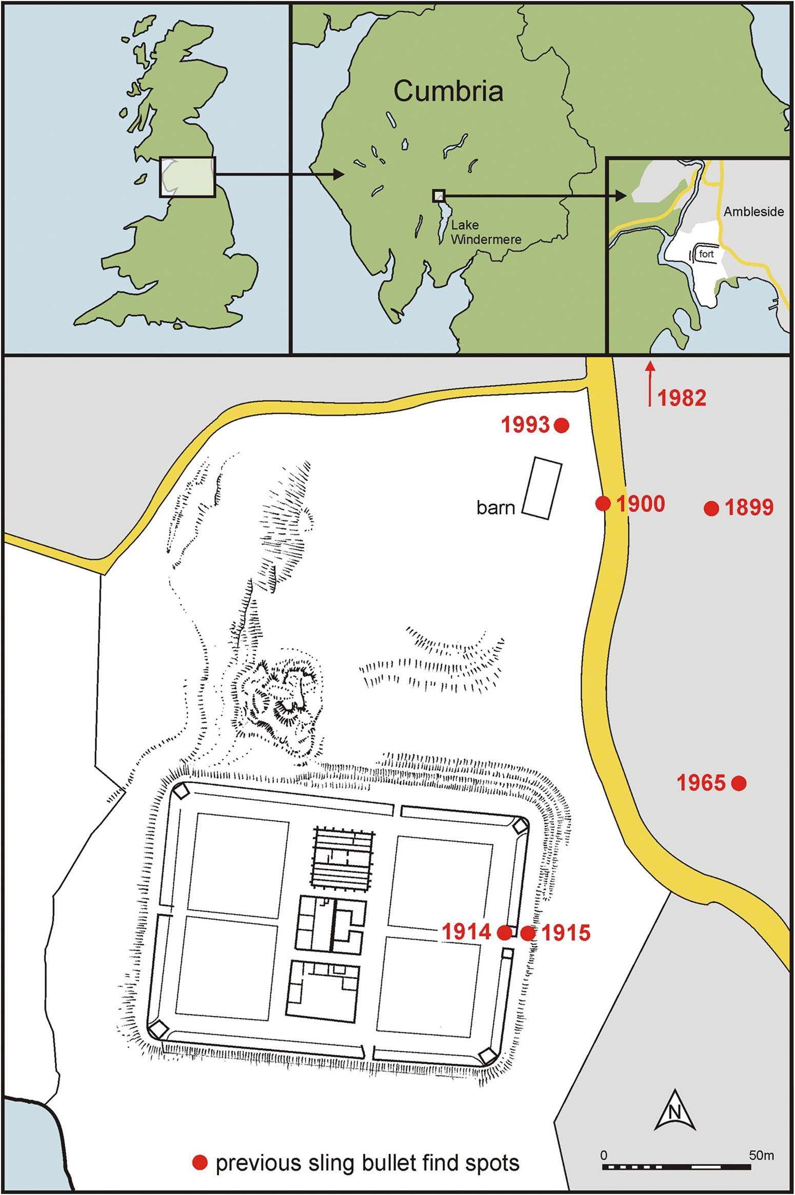
Fig. 2 Long description
The image shows a map with multiple sections. The top section includes a map of the United Kingdom highlighting Cumbria and a detailed view of Ambleside. The bottom section is a detailed plan of Ambleside fort, showing the layout of the fort and surrounding area. Red dots indicate previous sling bullet find spots with years labelled: 1899, 1900, 1914, 1915, 1965, 1982 and 1993. A barn is marked near the fort. A road runs along the right side of the map. A scale bar indicates 50 metres.
The fact that at Ambleside sling bullets have been found during various spatially limited interventions (e.g. road repairs, drainage channels) that disturbed the ground surface to the north and east of the fortFootnote 13 suggests the possibility of many more bullets being distributed over a wider area, thus pointing to a violent confrontation. Of interest is also the discovery of a ballista bolt tip.Footnote 14 Although the numbers of projectiles recovered over the decades at Ambleside remained relatively small, the widespread distribution of Roman lead sling bullets would be consistent with at least one episode of violence. In this context, we can also recall Haverfield’s mention that the stratigraphy of the towers could indicate that the fort was destroyed once or twice,Footnote 15 although the evidence from the early excavations is not completely clear in this regard.
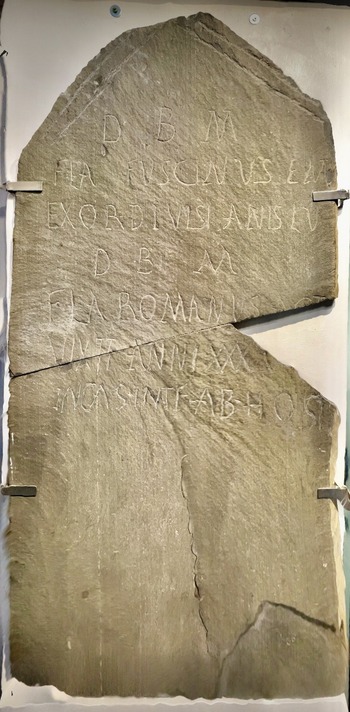
Be that as it may, another remarkable find is a Roman gravestone (currently displayed at the Armitt Museum in Ambleside) that was discovered in 1962, c. 100 m to the east of the fort.Footnote 16 This pivotal discovery carried an extraordinary inscription that bore testimony to an assault on the fort by unidentified ‘enemies’, which resulted in the death of possibly two of the garrison’s soldiers (perhaps father and son), one a retired centurion and the other an actarius (clerk)Footnote 17 (Fig. 3). The term used in the inscription is hostibus, ‘by enemies’, as opposed to latronibus meaning ‘by thugs or brigands’. The term hostibus tends to be reserved for enemy forces in times of war, suggesting that the soldiers may have died as part of a significant event. At the same time, the fact that the tombstone could be erected does suggest that occupation at the fort resumed after the attack. Unfortunately, there is no certainty in relation to the chronology of the tombstone, with possibilities ranging from the second to the fourth centuries a.d. (although a date in the late second or early third century a.d. is considered more likely by Thorley)Footnote 18
The unique double gravestone of Flavius Fuscinus and Flavius Romanus. The stone is on display in the Armitt Museum in Ambleside. (Image: Trimontium Trust).

Fig. 3 Long description
A Roman gravestone with visible inscriptions, displayed vertically and held in place by metal brackets. The stone is fractured into several pieces but remains assembled. The inscriptions are carved into the stone, though some parts are worn and less legible. The stone is set against a plain background.
.
The combination of these different sources of evidence (projectiles, tombstone inscription, and perhaps also destruction as indicated above for the towers) served as the starting point for a new conflict archaeology research project that we initiated in 2021. The work was the result of a collaboration between members of the Trimontium Trust and the University of Edinburgh. Building upon techniques of non-invasive wide-area metal detection developed at Burnswark Hill in south-west ScotlandFootnote 19 and recent conflict archaeology more generally,Footnote 20 we hypothesised that more bullets could be found in a random scatter to the north and east of the fort. We also reviewed all previously known sling bullets from Ambleside, determining that a total of 23 glandes had been recorded prior to our investigations.
A two-season fieldwork project was conceived. The first campaign aimed to determine the distribution of metal objects in the topsoil in areas available for surface survey outside the fort. The second campaign, for its part, was intended to retrieve a selected subset of these finds for detailed study where access would not threaten subsurface structures. Two principal caveats were acknowledged at the outset of the project:
1) that extensive recreational use of the area around the fort over the last couple of centuries would almost certainly have resulted in considerable metallic contamination;
2) that emergence of sling bullets into the topsoil from deeper levels beyond the optimal reach of modern detectors (<15 cm) for objects of this size would be serendipitous dependent on random agricultural activity.
As a mitigating factor, our hypothesis predicted that, as at the Roman fort of Velsen in the Netherlands,Footnote 21 the numbers of bullets that may have been deployed by defending Roman forces would be sufficient at least partly to counter these issues. In essence, like all diagnostic tests, the positive predictive value (PPV) of our technique (the prospective identification of lead bullets by metal detection) would increase with growing prevalence (in this case, the likely high number of Roman lead missiles expended in a conflict scenario).
The 2021 survey
In light of recent developments in battlefield landscape assessment, we used LiDAR data and aerial images to plan a non-invasive metal-detector survey to acquire new datapoints to help define the choreography of the suspected conflict. The survey took place between 17 and 21 September 2021 with the help of volunteers linked to the Trimontium Trust.Footnote 22
Metal-detector surveys were completed in 14 sectors of the site, focusing on the areas to the north and east of the fort. The southern and western sides of the fort were excluded from the survey, since these areas are covered by the lake itself and the boggy land around the adjacent River Rothay. The fieldwork was carried out using seven machines set in ‘all metal’ mode to ensure as complete a capture of data as possible. Point data were resurveyed using a single reference detector to ensure conformity of metal profiling. The likely metal type and hand-held GPS coordinates were individually recorded to <1m accuracy on a survey database.
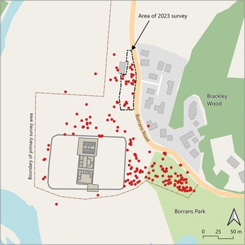
The results of the survey yielded over 1,000 data points corresponding to metal ‘targets’ of all types. After discarding some undetermined iron signals, the coordinates for 837 data points were recorded (Fig. 4). Subsequently, an attempt was made to trim the evidence down to possible lead artefacts. Modern metal detectors (for example, the XP Deus Mk II, which was used as the reference machine) have a digital readout function that allows a broad correlation with the type of metal and can easily differentiate, for example, between iron (0–9), lead (75–88) and most copper alloys (89–96). The detectorists taking part in this study were familiarised with replica lead bullets buried on a test site and became acquainted with their specific machine’s confidence levels for these types of targets. Each signal was then reassessed by the lead detectorist (JR), using a single reference machine (XP Deus Mk II) as the final arbiter. This triage allowed the identification of approximately 250 objects that could potentially represent Roman missiles, spread out in an arc to the north, east and south-east of the fort. While not all would correspond to Roman lead sling bullets (confounding factors could include Victorian coinage and non-Roman lead debris), comparison with the fieldwork carried out at Burnswark suggested that, if the prevalence of lead missiles was high enough, as might be predicted in a conflict scenario, a significant number of them could actually represent Roman projectiles (Fig. 5).
Ambleside fieldwork 2021: distribution map of metal-detecting signal locations, with colour-coded predictions. (Image: Trimontium Trust; map data from OpenStreetMap).

Fig. 4 Long description
The map illustrates the distribution of metal-detecting signals around Ambleside Roman fort and adjacent park area. The fort is centrally located within a boundary marked as the primary survey area. Surrounding the fort are clusters of coloured dots indicating the presence of metal signals. To the right of the fort, Brackley Wood is labelled and Borrans Park is situated below. The map includes a scale indicating distances of 0, 25 and 50 metres.
Ambleside fieldwork 2021: distribution map of metal detecting signal locations, where the predictions suggest a high possibility of lead. (Image: Trimontium Trust; map data from OpenStreetMap).

Fig. 5 Long description
A map illustrating the distribution of metal detecting signals with a high probability of corresponding to sling bullets, marked by red dots, around Brackley Wood and Borrans Park. The area of the 2023 survey is highlighted with a dashed line. The map includes a scale indicating distances of 0, 25 and 50 metres. The boundary of the primary survey area is outlined, encompassing a central structure. The map also features roads and surrounding green areas.
The 2023 survey and excavation
In order to test this hypothesis, a new fieldwork campaign was carried out between 21 and 24 August 2023, again involving the participation of volunteers linked to the Trimontium Trust. The main aim was to carry out a detailed metal-detector survey in a reduced area to the east of the barn, where fieldwork during the more extensive but less intense 2021 survey had identified 24 signals that might be consistent with lead sling bullets. The selected area was located adjacent to Borrans Road and comfortably within the margin of the likely casting range of bullets slung from the north-east corner of the fort. The casting range of lead bullets from slings in use by the Roman army has been estimated to be between 200 m and 250 m, but it is likely that expert slingers could cast lead glandes significantly further (Griffiths Reference Griffiths and van Driel-Murray1989; Skov Reference Skov2011). This area would be in the direction of, but not necessarily within, the suspected fort vicus. At this time, too little is known about the dating and siting of the vicus to speculate whether buildings would have been present in this area at the time of the proposed assault upon the fort.
The 2023 high-resolution survey was accompanied by micro-test pits at locations where the signal suggested a potential lead object in order to allow the extraction of finds immediately below the surface. Previous geophysics had suggested that few subsurface structures survived in this area,Footnote 23 so there was very low risk of damaging in situ archaeology when extracting the objects.
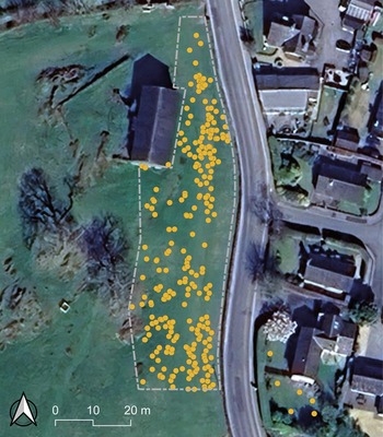
The 2023 survey was organised in 20×20 m squares, with ropes being used to create a series of 2 m wide north–south transects that were systematically surveyed. All signals were plotted using a DGPS with an accuracy of <2 cm, and British National Grid (OSGB36) was employed for all coordinates. Data were collected using MapIt Spatial on an Android tablet and plotted using QGIS. The aim was to extract c. 40 targets linked to the most likely signals that might be associated with lead sling bullets. In total, detecting for all metals, the 2023 survey yielded 258 signals near the barn (compared to approximately 63 signals recorded in this area during the less intensive 2021 survey), to which we added a further six signals in the garden of Galava Shiel, just across Borrans Road (Fig. 6).
Ambleside fieldwork 2023: metal-detecting signal locations. (Image: Trimontium Trust; image data: Google 2026; Airbus).

Fig. 6 Long description
An aerial view shows a field with numerous orange dots scattered across it, indicating signal locations. The field is bordered by a road on the right and several buildings, including a large rectangular structure (the barn) near the top left. The area is outlined with a dashed line and a scale bar at the bottom left indicates distances of 0, 10 and 20 metres. The surrounding area includes additional buildings and vegetation.
The density of survey signals during the first day of fieldwork was used to calculate an optimal set of signals for extraction. A total of 33 signals were identified as high priorities during this process as they matched the profile of potential lead sling bullets, using the same criteria as in 2021, and checked using the same reference instrument, operator and settings. Another group of six additional signals were initially screened out as less likely to be significant but were selected as worth investigating, particularly to check whether the threshold for significance had been appropriate.
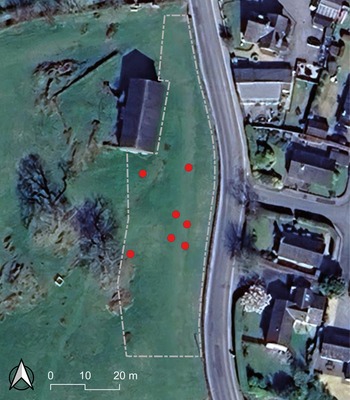
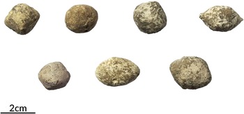
All extracted targets were in the topsoil. This was always within 20 cm of the present ground surface, and frequently the objects were very close to the surface. Thus, excavation caused minimal disturbance and only developed soils were excavated with no indication of any archaeological features. Out of the 39 extracted targets, seven contained individual Roman lead sling bullets, thus increasing the number of known glandes from Ambleside fort and its environs from 23 to 30 (Figs. 7–8).
Ambleside fieldwork 2023: location of the Roman sling bullets. (Image: Trimontium Trust; image data: Google 2026; Airbus).

Fig. 7 Long description
An aerial view shows a field with several red dots indicating sling bullet locations scattered within a dashed boundary. The field is adjacent to a road, with residential buildings on the opposite side. A large building (the barn) is located within the field's boundary. A scale indicating 0 to 20 metres is present at the bottom left corner, along with a directional compass symbol.
Composite photograph of the seven Roman sling bullets recovered during the 2023 fieldwork campaign. Note the mix of ‘conventional’ biconical ovoids with more irregular morphologies. (Image: Trimontium Trust).

Fig. 8 Long description
Seven Roman sling bullets are arranged in two rows. The top row contains four bullets and the bottom row has three. Each bullet varies slightly in shape and texture, with a rough surface. A scale indicating 2 centimetres is visible in the bottom left corner.
From a methodological perspective, the results were rather positive in regard to the utility of metal detectors to identify the potential presence of lead sling bullets. It is interesting to note that no lead sling bullets were found among the six lower-probability targets that were extracted, and we would argue that the miss rate of sling bullets in the topsoil during this survey was probably very low. Conversely, all sling bullets recovered resulted from the 33 signals predicted to have a high significance. Given the range of possible objects and materials, as well as the subjective element both in instrument and operator, recovering seven glandes from 33 high-probability signals should be seen as a relatively efficient process of sling bullet location. The results also suggest that many more Roman sling bullets remain in the ground in the environs of the fort, since a considerable number of the data points recorded during the 2021 survey could indeed correspond to glandes.
Among the high significance signals that did not result in a sling bullet, there were several old pennies and notably a series of metal objects with holes in them (e.g. buckles and even a curtain ring). While the former were expected, as there is a known overlap between the signals from older copper-alloy coins and sling bullets, the latter correlation is both significant and interesting. The morphology of an object is known to impact the detector signal and it seems that metal objects (often iron) with a large hole within them can produce the same signal as a lead sling bullet.Footnote 24
Sling bullet analysis
As mentioned above, in addition to the fieldwork we also reviewed the previously known Roman sling bullets from Ambleside. The morphology of the objects makes it possible to identify two clearly differentiated groups of glandes (Fig. 9), and microscopic samples of lead were extracted and sent for isotopic analysis to S. Klein and R. Müller (Deutsches Bergbau-Museum Bochum, Germany). The preliminary results are very interesting, as the lead used to manufacture the projectiles appears to have originated from two separate sources that align with the two different morphological groups.Footnote 25 The more regular group of sling bullets appears to have close similarities to the bullet shape and lead ore of many of the missiles used by Roman troops at Burnswark around the mid-second century a.d., whereas the second more irregular group has a more hastily manufactured appearance and an as yet unidentified source.
Lead sling bullets from legacy investigations at Ambleside. The top two exhibit the conventional biconical ovoid shape, and the lower six show varying degrees of dysmorphism, which may indicate hasty or improvised production. (Image: Trimontium Trust).

Fig. 9 Long description
Eight lead sling bullets are displayed on a flat surface. The top row consists of two bullets with a conventional biconical ovoid shape. Below them are six bullets exhibiting varying degrees of irregularity and dysmorphism, suggesting hasty or improvised production. A scale is present, indicating a measurement of two centimetres, providing a reference for the size of the bullets.
Samples from the seven newly found sling bullets from the 2023 campaign were also sent for isotope analysis, alongside lead slag from Collingwood’s excavations and galena samples from local lead mines (Fig. 10). The preliminary results show that the seven most recent bullets (red triangles) conform to one or other of the two main groupings of previously excavated missiles (yellow triangles), strengthening the temporal relationship. Moreover, there appears to be an association between one of the main bullet clusters with a group of lead slag samples from the site, suggesting that at least some of the bullets used by the fort’s defenders were manufactured from lead available at Ambleside.
Isotopic analysis of the legacy Ambleside sling bullets (yellow), galena and slag (blue), incorporating the 2023 finds (red). (Image: R. Müller).

Fig. 10 Long description
A scatter plot titled ‘Ambleside bullets and slag' displays isotopic analysis data. The x-axis is labeled 'superscript 206 Pb by superscript 204 Pb' and the y-axis is labelled ‘superscript 207 Pb by superscript 204 Pb'. Data points are marked with different symbols: blue diamonds for ‘Ambleside23_Slag', yellow triangles for ‘Ambleside' and red triangles for ‘Ambleside23_Bullets'.
Conclusion: a battle at Ambleside
In terms of wider interpretation, the new results derived from the 2023 campaign have confirmed our hypothesis that part of the ‘high suspicion’ signals from the 2021 survey actually correspond to a spread of Roman lead sling bullets. This significantly reinforces the interpretation that the Roman fort at Ambleside suffered at least one attack by an external enemy, during which the Roman soldiers defended themselves by shooting out projectiles in the form of lead sling bullets. This is one of the very few archaeologically documented cases in the whole of Europe of a Roman military camp being attacked by an external enemy, thus comparable to the cases of Andagoste in first-century b.c. northern SpainFootnote 26 and Velsen in the Netherlands during the first century a.d.Footnote 27 In the case of the latter, the assault is thought to have taken place in a.d. 28, when the Frisii revolted in response to excessive taxation by the occupying Roman forces. The Roman sling bullets documented at Velsen were also of varying quality of craftsmanship, with indications that many had been made rapidly under highly stressful conditions. As indicated above, something similar can be suggested for Ambleside.
However, many questions remain open. For example, we do not know the identity of the attackers at Ambleside. Were they locals from the Lake District as part of an uprising against Roman power? Or are we dealing with the remains of an attack by fighters from the north that had crossed Hadrian’s Wall? The chronology of the event is also unclear. The lead sling bullets from Ambleside, which weigh on average 50 g, can most likely be attributed to the second century a.d., due to strong morphological similarities (biconical ovoid with nipple-shaped extremities) of some of the Ambleside group to other examples found elsewhere in second-century contexts, notably at Burnswark Hill.Footnote 28 The morphology of Roman lead sling bullets from the Late Republican period into the first century a.d. tends to be lighter (<45 g) and more almond-shaped, such as those found at Windridge Farm.Footnote 29 Where lead bullets have been recovered from third- and fourth-century contexts such as Corbridge, Vindolanda and Krefeld-Gellep, they tend to be heavier (>60 g), irregular in shape, or spherical.Footnote 30 Roman troops also utilised clay bullets, but none have been found at Ambleside. It is interesting to note that baked clay missiles appear to be mainly associated with first-century installations.Footnote 31 However, the dating of the inscription is more uncertain and could potentially be later than the lead sling bullets. Thus, we cannot exclude the possibility of the fort being attacked more than once.
Despite these uncertainties, we believe that the combination of previous findings and new investigations allows us to establish the existence of at least one conflict event at Ambleside, during which the fort was attacked and the garrison defended itself by a missile barrage, possibly from the walls and towers of the fort. This new research has also attracted public attention, as reflected for example by the exhibition ‘A Battle of Ambleside’ organised by the Armitt Museum between February and December 2025 (https://www.armitt.com/a-battle-of-ambleside/). In any case, the example of Ambleside demonstrates the possibility of violent confrontations in the territories south of Hadrian’s Wall several generations after the initial Roman conquest, thus adding to the growing corpus of conflict archaeology evidence in the borderland regions of the Roman Empire.
Acknowledgements
We would like to thank the Cumberland and Westmorland Antiquarian and Archaeological Society for their financial support, which made possible the two fieldwork campaigns. Special thanks also go to all the volunteers from the Trimontium Trust that participated in the fieldwork, as well as to Eleanor Kingston (Lake District National Park Authority), Jamie Lund (National Trust), Pete Owen (Historic England) and Faye Morrissey (Armitt Museum). Sabine Klein and Regine Müller (Deutsches Bergbau-Museum Bochum) kindly carried out the isotopic analysis. Finally, we would like to thank Lawrence Keppie and Rachel Cartwright for providing comments on an earlier version of this article.




 Open access

