

Introduction
Structures on the Burroughs Glacier in Glacier Bay National Monument, Alaska, were investigated during the summers of 1959 and 1960 by members of the Institute of Polar Studies and Department of Geology, The Ohio State University, under support from a National Science Foundation grant. The objective was to determine the characteristics and origin of structures and related fabric in ice which was once 300 to 400 m. beneath glaciers of the Little Ice Age. This study is the first detailed analysis of structures in a rapidly wasting detached ice mass with wholly negative mass balance. This paper is based upon a more detailed discussion prepared as a doctoral dissertation at The Ohio State University and as a report to the National Science Foundation submitted by the Institute of Polar Studies (Reference TaylorTaylor, 1962, Reference Taylorunpublished).
General Features of the Glacier
The Burroughs Glacier in south-eastern Alaska is a rapidly ablating remnant (14 × 3km.) of a large glacier system that extended, during the Little Ice Age, to the mouth of Glacier Bay nearly 100 km. from the terminus of present tide-water glaciers (Fig. 1). During this advance the ice in the valley of the Burroughs Glacier was at least 300 m. thick and between 460 and 600 m. thick in the neighboring inlet. Thus, many of the structures now appearing on the glacier were formed at great depths, while others, produced by present ice movement, are superimposed upon these relict forms.
Map of the Muir Inlet region, Glacier Bay, Alaska. Adapted from American Geographical Society map (Reference FieldField, 1947)

The Burroughs Glacier is a temperate type, entirely below the firn line, rising from near sea-level to 500 m. elevation. Between 1948 and 1960 the ice surface dropped at the rate of 0.8 m./yr. on the 500 m. crest of the glacier and 6.8 m./yr. at the eastern terminus. The present annual ablation varies from 670 cm. of water at 100 m. elevation to 350 cm. of water at 400 m. elevation. The decrease in ablation with elevation averages about 0.9 cm./day/ 100 m.
Surface velocity during an 11-month period, August 1959 to July 1960, varied between 6.7 m. at 425 m. elevation to Less than 0.5 m. at 200 m. elevation near the terminus. A study of glacier topography from a map compiled in 1960 reveals a relationship between curvature of contours along the glacier center line and velocity change in the ice. Maximum velocity occurs where contours change from convex up-glacier to convex down-glacier, and the greatest change in velocity occurs where the radius of curvature in succeeding contours has its greatest change.
Glaciation
The history of glaciation in this area has been traced by Reference GoldthwaitGoldthwait (unpublished) from a detailed study of the glacial stratigraphy and an analysis of radio-carbon dates of logs buried in place. The history can be summarized briefly as follows:
Retreat of late Wisconsin ice which exposed scoured bedrock and left till and outwash, followed by the development of late Wisconsin soil and establishment of a mature Picea and Tsuga forest.
Filling of fiords and burial of forest with outwash as ice retreat or fluctuation continued.
Establishment of Picea and Populus on the younger outwash. Trees on outwash at lower levels were buried while other trees were established at higher levels. Radio-carbon dating of in-place logs at successively higher levels indicates that glaciers were in the retreat position between 7000 and 2500 b.p.
Re-advance of ice marking the Little Ice Age occurring as early as 2750 b.p. and continuing to about 300 b.p. with burial of older outwash by till and outwash related to this advance. Excavation of earlier outwash in some fiords.
Retreat of ice commencing about 300 b.p. with the tide-water terminus moving back as much as 100 km. from the entrance of Glacier Bay to the present position (Fig. 1).
Downwasting
Reference ReidReid (1896) and Reference GilbertGilbert (1904, p. 16–45) estimated that the ice at its maximum extent may have exceeded 915 m. in thickness in upper Muir Inlet and perhaps 1,122 m. in thickness in the upper part of Reid Inlet.
Recent evidence indicates that when the Burroughs—Plateau Glacier system was at its maximum height during the Little Ice Age, the surface of the ice over Wachusett Inlet was at least 460 m. above sea-level. A lichen trim line is evident at about 460 m. elevation on the east wall of a cirque below the Patton Glacier facing Wachusett Inlet (Fig. 1). The line corresponds approximately to the level of ice given by Reference ReidReid (1896, p. 443) for this locality in 1892, which suggests that the ice may not have been much higher at this locality during the maximum advance 100 yr. earlier. The inlet, which was filled with outwash gravels deposited during hypsithermal time, probably was being deepened by glacial erosion as rapidly as the ice was thickening. The total thickness of the ice probably was more than 600 m., allowing for the present depth of the inlet, about 140 m.
The ice thickness was greater in the inlet than on adjacent uplands. Along Minnesota Ridge, at the time of Reid’s investigation, the ice was at an elevation of 760 m. whereas the lowest bedrock valley along the south-west side of Minnesota Ridge is about 530 m. Thus the ice thickness here in 1892 was not more than about 230 m. thick compared to nearly 600 m. of ice in Wachusett Inlet.
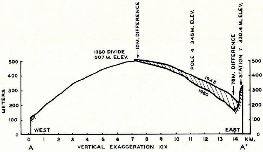
A comparison of the 1948 and 1960 topographic maps shows that the Burroughs Glacier surface at the ice crest dropped from 517 to 507 m. during this 12–year period (0.8 m./yr.), whereas at the terminus, near station 7, it dropped from 213 to 135 m. (6.5 m. /yr.). Profiles from the 1948 and 1960 maps are plotted together in Figure 2 to show the change in ice loss with:elevation.
Longitudinal profiles from the 1918 and 1960 to pographic maps, lower Burroughs Glacier
Retreat
The retreat of the Burroughs and Plateau Glaciers has been carefully observed from 1913 to the present. The tide-water terminus of the Plateau Glacier is now opposite the Baldwin Glacier (Fig. 1). Over a period of 47 yr. (1913 to 1960) the ice front retreated 11.8 km. at an average rate of 252 m./yr. Field (unpublished) observed that rate of recession varied proportionally with the width of the inlet.
Reference FieldField (unpublished), Reference MercerMercer (1961) and others have concluded that the catastrophic retreat of the tide-water terminus in Glacier Bay (100 km. since the late 1700’s) was due largely to the configuration of the fiord. A raising of the firn limit was responsible for the initial retreat of the terminus from the narrow entrance to Glacier Bay. Since the fiord is progressively wider inland, the width of the retreating tide-water terminus became progressively wider also which increased loss of ice by calving and by melt beneath the floating tongue.
Firn Line
The firn line is “the highest level to which the fresh snow cover on a glacier’s surface retreats during the melting season” (Reference Matthes and MeinzerMatthes, 1942, p. 161) and therefore it is approximately the dividing line between the accumulation area and the ablation area.
The early reports of Vancouver gave no indication of the position of the firn line in the Glacier Bay area, nor did reports by Reid in 1892. In Reid’s time the Cushing Plateau formed a broad ice dome over Minnesota Ridge (Fig. 1) which suggests that prior to this time the ice plateau was a center of accumulation and therefore above the firn line.
From studies still in progress, Field (unpublished) estimates that the firn line in the Muir-Queen Inlet drainage area was between 685 and 760 m. during the Little Ice Age advance.
Reference MercerMercer (1961, p. 857) suggests that the firn line may have started to rise some time before the terminus reached its maximum position at the mouth of Glacier Bay. In the late stages of advance, as the ice approached the neck at the entrance to Glacier Bay, the tide-water terminus became progressively narrower which reduced the ice wastage significantly. Therefore, even though there was a slowing down in absolute movement of the ice due to a rise in the firn line, the glacier terminus continued to advance; the decrease in wastage at the terminus overcompensated for the decrease in ice motion.
The present firn line on the international boundary (Fig. 1) for ice which feeds the Riggs, Muir, Cushing, Carroll and Rendu Glaciers is estimated at 1,160 m. or above (Goldthwait, unpublished). Firn lines of other glaciers within 120 km. of Glacier Bay are: Lemon Creek Glacier, 1,175 m.; Little Jarvis Glacier, 1,250 m. (American Geographical Society, 1960) and Taku Glacier, about 1,035 m. (Reference NielsenNielsen, 1957).
Observations of Ice Structure
Structures were investigated in detail on the eastern tongue of the Burroughs Glacier. In this area the attitudes of layers and fractures were mapped and the ice fabric on the walls of pits, crevasses and moulins, and in ice cores was observed. The general trend of the structures on the remainder of the glacier was determined from an analysis of aerial photographs taken in 1960 and from observations made on numerous traverses on the eastern half of the glacier.
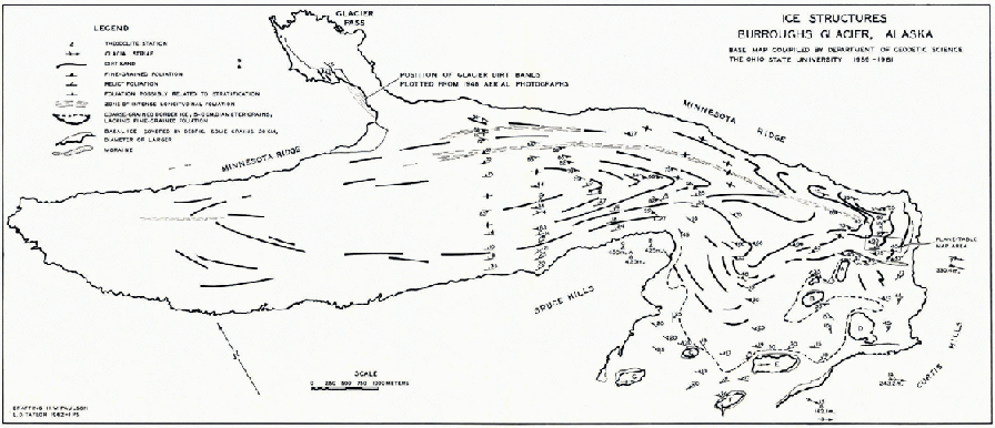
A general map of ice structures, exclusive of crevasses, is presented in Figure 3. Three general kinds of ice have been identified:
Foliated ice which consists of fine-grained layers and bubble layers in a groundmass of irregular crystals 0.1 to 5.0 cm. diameter. It occurs on most of the glacier surface above 225 m. elevation.
Coarse-grained border ice which generally lacks both fine-grained layers and bubble layers, and has crystals 5.0 to 10.0 cm. in diameter. It contains a series of planar surfaces produced by the alignment of coarse crystal boundaries, distributed in the same manner as fine-grained foliation. This structure has been mapped as relict foliation. Moderately coarse ice covers a zone approximately 0.25 to 0.5 km. wide near the eastern terminus.
Very coarse-grained basal ice which consists of crystals 10 to 20 cm. in diameter or larger and is generally covered by a thick layer of debris. It is exposed in discontinuous narrow zones at the ice margins, particularly around nunataks.
Ice structures, Burroughs Glacier. Base map compiled by Department of Geodetic Science, The Ohio State University, 1939–61
In studying the genesis of structures it is important to keep in mind that the ice at both termini is older, and has traveled farther and deeper than the ice at the crest. This assumption is based upon Reference FinsterwalderFinsterwalder’s (1907) kinematic or geometric theory of ice movement. According to this theory a firn particle originating in the accumulation area is carried downward and forward in the glacier until it reaches the firn line and then is carried upward and forward toward the surface, finally appearing at the surface at some point in the ablation zone. The motion occurs in a continuous line, and those particles originating farthest up-glacier will reach the greatest depth on approaching the firn line and will have traveled the longest distance upon reaching the surface again.
Ice in the eastern tongue of the Burroughs Glacier may be older than that at the western tongue, provided the source for the glacier was far to the west in the valley of the Cushing Glacier (Fig. 1). On the other hand, ice at both termini may be of nearly the same age, if its source was near the present ice crest from which ice flowed to the east and west.
Crevasses and Fractures
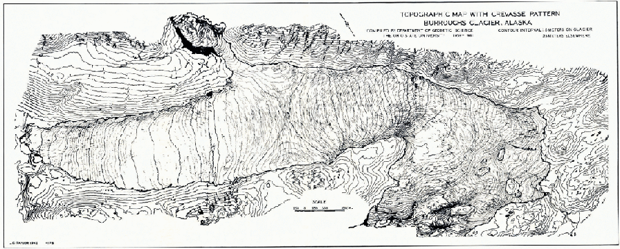
As has been observed by Reference HopkinsHopkins (1862), Reference NyeNye (1951) and Reference MeierMeier (1960), the crevasse and fracture patterns on a glacier are controlled by the stress field and are therefore good indicators of the stress conditions. On the Burroughs Glacier two principal crevasse patterns are present (Fig. 4): a transverse pattern in the upper glacier and a longitudinal pattern in both ends of the lower glacier. According to Reference NyeNye’s (1951) theory of crevasse patterns, the transverse pattern is associated with an increase in flow velocity down-glacier. The principal stress is tensile, normal to the direction of the crevasses. The transverse system grades into a longitudinal system between 400 and 450 m. elevation on the eastern and western tongues (Fig. 4). Below this elevation the velocity decreases down-glacier and the principal stress is compressive and parallel to the crevasse direction. A plane-table map (Fig. 5), at a scale of 1 : 1,200, was constructed near the terminus of the eastern tongue. This map was prepared in order to relate ice fabric to present structures and to help interpret the local stress field. The strike and dip of foliation, the trend of dirt bands at the surface, all crevasses, and about 85 per cent of all fractures are mapped.
Topographic map with crevasse pattern, Burroughs Glacier. Compiled by Department of Geodetic Science, The Ohio State University, 1959–61
Fabric diagrams and plane table map of ice structures, lower Burroughs Glacier
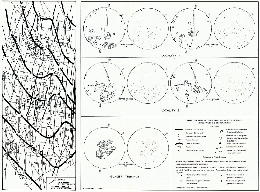
Two sets of crevasses are present (Fig. 5). The prominent set is nearly parallel to the lobe axis and the longitudinal foliation. The other set intersects the first at angles between 30 and 45°. The crevasses generally do not exceed 30 cm. in width and to m. in depth, and all are nearly vertical. The amount of opening and closing of 14 crevasses was measured between 19 July and 23 August 1960. During this 35–day period to crevasses widened between 1.3 and 5.7 cm. (an average of 3.0 cm. per crevasse), while 4 crevasses closed between 2.0 and 5.0 cm. (an average of 4.0 cm. per crevasse). Although these measurements represent only a small portion of the total number of crevasses in the map area, they suggest that extension is still taking place near the terminus at a very low rate.
Examination of the fracture patterns (Fig. 5) shows that there are three principal sets: a transverse set which dips up-glacier between 50 and 70°, a longitudinal set which is generally vertical and is related to the principal crevasses, and finally, a more recent set which trends east-west, offsets the others, and dips between 75° south and 90°.
The transverse fractures, a series of steeply dipping thrust faults, were probably produced by longitudinal compression of the ice as it flowed into the basin beneath this eastern tongue. These faults correspond to Nye’s possible slip-line fields or fault planes (Reference NyeNye, 1952, p. 88) for “compressive flow”. This same longitudinal compression caused the ice to expand laterally and produce the crevasses.
The longitudinal fracture system is related to this crevasse system and represents an early stage in the formation of crevasses.
The east-west fractures are more difficult to explain. The offset of the transverse fractures by this set indicates that the north side of the fracture planes moved eastward. The east-west fracture set is parallel to the linear pattern in the topography of the Curtis Hills east of the terminus (Fig. 4) and also parallel to the axis of the fold in the dirt bands. Since this fold is not an expression of ice surface topography, which is extremely smooth in this area, a lateral variation of surface velocity must be responsible. The variation could be caused by a local topographic ridge beneath the ice with an orientation parallel to the fold axis of the bands and the trend of the fractures. Therefore, these are probably recent shear fractures produced by local irregularities in the sub-ice topography. This local shear deformation may be responsible for the minor system of crevasses at locality “B” (Fig. 5) which are nearly parallel to these fractures.
An attempt was made to measure the strain-rate at locality “A” at the glacier surface. The procedure suggested by Reference NyeNye (1959) for determining the strain-rate tensor was used. The greatest principal axis of strain which is plotted on the plane-table map (Fig. 5) was found to be compressive (−0.013/Yr.) and in a north-south direction, nearly parallel to the direction of overall ice movement measured at locality “B” (pole 8).
Since crevasses are still widening in this area, although by only a few centimeters a year, the principal compressive strain axis should be orientated parallel to these crevasses rather than at 45° to them. The only way to explain this anomalous strain direction is to assume that the crevasses are produced by shear stresses. The east-west fractures, many of which dip steeply to the south, are normal to the principal strain axis and may be reverse faults produced by a compressive stress. However, this would not account for the eastward displacement of the north wall of these faults.
The validity of the strain-rate measurements is doubtful, mainly because movement was very slight and ablation very high. It is advisable to use these measurements cautiously in interpreting the local stress field and its relationship to ice fabric.
Foliated Ice
Ice foliation, as defined on this glacier, is a planar structure produced by shear or compression and consists either of alternate layers of bubble-rich and bubble-free ice, or of alternate layers of fine- and coarse-grained ice. In some cases the bubbles or grains are elongated in the plane of the layer. The foliation plane develops in a direction of least resistance to stress which is determined by the configuration of the valley walls and floor, the stress field in the glacier and the anisotropic properties of the ice.
Any textures directly related to firnification apparently have been obliterated, for the Burroughs Glacier was buried under as much as 300 m. of ice during the Little Ice Age, during which time the ice underwent considerable deformation.
Since a close examination of structures in the upper glacier was not undertaken, the relationship between the fine-grained layers, bubble layers and the surface banding there is not clear. The classification of structures is based mainly upon the structural relations observed in the eastern tongue (Fig. 6).
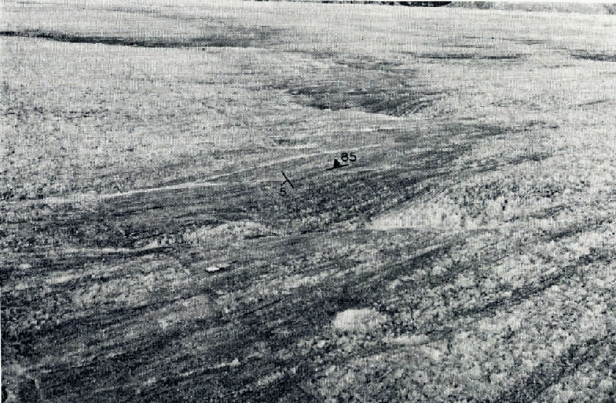
Aerial view of the eastern tongue of the Burroughs Glacier fiom 2,135 m. elevation (7,000 ft.), showing the distribution of splaying crevasses and dirt bands. Medial moraine is at the upper edge of the photograph and Minnesota Ridge al the lower edge. Width of the tongue is 1 km.

The structural arrangement of the foliation in the eastern tongue can best be shown by a block diagram (Fig. 7) which is a somewhat simplified representation of conditions in this part of the glacier. The fine-grained layers in this area are separated by well-defined areas of very coarse ice.
Schematic block diagram illustrating structural relationships in the eastern tongue, Burroughs Glacier. White areas represent coarse-grained ice. Fine lines represent fine-grained foliation. Vertical stale exaggerated
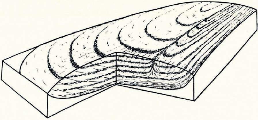
One system of ice foliation consists of longitudinal layers which are vertical.near the center line but parallel to the valley walls at the margins and probably parallel to the valley floor at depth. This foliation is caused by faster flow of the ice at the center line than at the margins, and faster flow at the surface than at the bottom, which produces differential movement and recrystallization along closely spaced layers.
The longitudinal foliation also occurs with less intensity across the entire lobe. The distribution of this foliation resembles that described by Reference Streiff-BeckerStreiff-Becker (1952, p. 6) for the Grosser Aletschgletscher, except that in his case a series of coalescing glaciers are present, each with its individual foliation pattern.
Foliation also occurs as steeply dipping layers concentrated in narrow longitudinal zones. These zones of foliation resemble, to some extent, the “longitudinal septum” described from the Blue Glacier (Reference AllenAllen and others, 1960) and the Feinbander described from the Pasterzegletscher (Reference UntersteinerUntersteiner, 1955). On the Blue Glacier the foliation is produced by strong differential movement between two ice flows which coalesce at the base of an ice fall below a rock bastion. The zone of intense foliation persists down-glacier almost to the terminus, where differential movement between adjoining ice flows no longer exists. After the foliation is produced beneath the rock bastion, it is carried passively down-glacier maintaining most of its original characteristics.
The distribution of the foliation zones on the Burroughs Glacier suggests an origin similar to the one proposed above by Reference AllenAllen and others (1960) for the “longitudinal septum”. The foliation zone nearest the glacier margin probably was produced by ice from Glacier Pass coalescing with the Burroughs Glacier, while the longer set was produced farther to the west by ice of the easternmost end of the Carroll Glacier coalescing with the lower Cushing Glacier (Fig. 1). In the latter case the foliation was carried eastward some distance from its source.
The present direction of ice flow, to the east and west from an ice crest, cannot be responsible for these zones of longitudinal foliation since no tributary glaciers are present in the immediate vicinity, except the dying glacier in Glacier Pass, which is supplying a negligible amount of ice. The longitudinal foliation is a very old feature produced during the Little Ice Age by ice flowing from east to west through the Cushing and Burroughs valleys.
A gently dipping foliation forming a shallow trough-like structure is also present. This foliation consists of fine-grained layers concentrated at definite horizons which are separated by coarse ice. These horizons form a series of dirty arcuate bands at the surface, which conform to the shape of the tongue. At the margins of the tongue the other foliation, which is consistently longitudinal, is parallel to the bands; but near the center line this foliation crosses the bands, producing a series of offsets similar to a shear-fold pattern in dynamically metamorphosed sediments (Fig. 8).
The ice surface on the eastern tongue of the Burroughs Glacier. Terminus toward the right. Dirty hands consist of two systems of fine-grained foliation as designated on the photograph. Bands are convex down-glacier. Note the Brunton compass at the lower left of center
Ablation in the bands is greater than it is in the intervening coarse ice, mainly because the bands contain fine ice with more grain boundaries per unit area. An undulating micro-topography results from the differential ablation (Fig. 8).
It is possible that the gently dipping foliation formed much farther up-valley, in the vicinity of the Cushing Glacier. With subsequent flow the foliation planes were drawn out into the trough-like structures of the present Burroughs Glacier. In its early stage of formation the foliation may have developed either according to Nye’s theoretical slip-line fields postulated for “compressive” and “extending flow” (Reference NyeNye, 1952, p. 88), or parallel to stratification planes which were present in the accumulation basin at the head of the Cushing valley.
The fine-grained layers vary from 0.5 to 5.0 cm. in thickness and contain inequigranular crystals from 0.5 to less than 0.1 cm. in diameter. Reference Ahlmann and DroesslerAhlmann and Droessler (1949, p. 273–74) observed similar fine-grained layers in coarse-grained dead ice of the Kebnepakteglaciären. There is no apparent difference in the textures of the steeply dipping and gently dipping layers except that the steeply dipping folia tend to be slightly thinner, of the order of 0.5 to 2.0 cm. The actual thickness is often difficult to measure since many of the folia coalesce.
The coarse ice separating the fine layers contains very irregular and inequigranular crystals from 0.5 to 10.0 cm. in diameter. Thin bubble layers occur at irregular intervals throughout this ice; they are generally parallel to the gently dipping layers of fine-grained ice. This texture can be seen in a photograph of an ice thin section (Fig. 9). The contact between the fine-grained layer and the coarse ice is sharp and planar, as shown in the thin section and in the photograph of a pit wall (Fig. 10). Elongation of grains and bubbles was not observed in either the coarse or fine ice.
A vertical thin section under polarized light showing typical texture of foliated ice. Sample from 2 m. depth. Scale in centimeters

East wall of the 2 m. pit showing two systems of fine-grained foliation. Eastern tongue of Burroughs Glacier

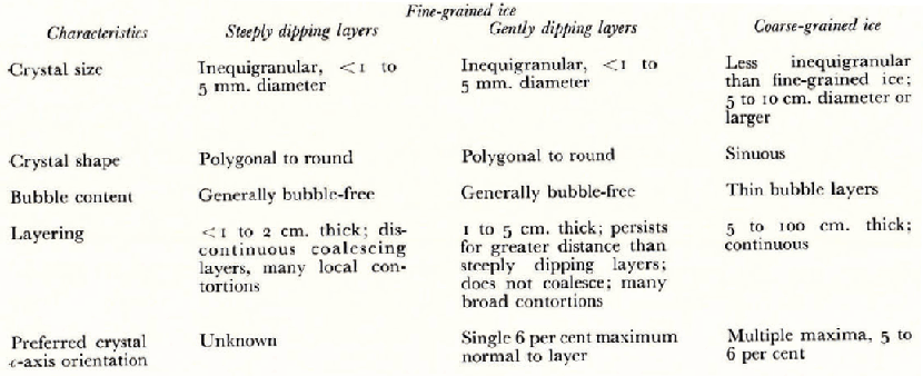
A summary of the characteristics of foliated ice in the eastern tongue of the Burroughs Glacier is presented in Table I.
Characteristics of Foliated Ice
Crystal Orientation in Foliated Ice
In the detailed work done near the eastern terminus the orientations of c-axes in coarse-grained and fine-grained ice were determined for a total of 1,000 crystals. A Rigsby Universal Stage was used, following the standard techniques introduced by Reference BaderBader (1951), Reference RigsbyRigsby (1951) and later summarized by Reference LangwayLangway (1958).
200 fine crystals (1 to 5 mm. diameter) and 200 coarse crystals (5 to 10 cm. diameter) were measured at locality “A” and an equal number at locality “B” (Fig. 5). These sites are approximately 150 m. apart and 600 m. from the ice edge. Thin sections, most of them cut horizontally, were taken from orientated 7.5 cm. diameter cores, from 0.5 to 2.0 m. below the surface.
An average of 5 coarse crystals and 7 fine crystals were measured in each thin section before the thin section disintegrated. Generally, in the coarse ice only about 7 partial crystals comprised a thin section, but in the fine ice as many as 100 crystals were present. Approximately 138 thin sections were needed for the measurements.
An additional 200 crystal orientations were observed in very coarse ice near the glacier terminus. These crystals were measured in situ, using a Brunton compass to determine the strike and dip of etched basal sections and Tyndall figures within single crystals.
The orientations of fine and coarse crystals in foliated ice were plotted separately on a Schmidt equal-area net (lower hemisphere) and their concentrations were contoured according to the method introduced by Reference SchmidtSchmidt (1925, p. 392) and described by Reference FairbairnFairbairn (1954, p. 285–91). Since contoured diagrams are often misleading and weak maxima often overemphasized, the distribution of c-axes and poles to structural elements is presented with the contoured diagrams (Fig. 5).
The following relationships are evident in the fabric diagrams from localities “A” and “B” at the eastern terminus of the Burroughs Glacier (Fig. 5).
General pattern
1. All diagrams show that the strongest maxima occur in the south-eastern quadrant.
2. All diagrams, for both fine and coarse ice, show that a single maximum of from 4 to 6 per cent occurs in approximately the same position.
Fine-grained ice
3. A maximum of 6 per cent occurs at both localities “A” and “B” in approximately the same position.
Coarse-grained ice
4. Three broad maxima of from 5 to 6 per cent occur at locality “A”.
5. Four weak maxima of 4 per cent occur at locality “B” and appear at the same general position as two maxima at locality “A”.
Relationship to planar features
6. The single maximum for fine-grained ice occurs close to the pole of the plane of the gently dipping fine-grained foliation.
7. Two maxima for coarse ice occur close to the poles of principal fracture planes and one other maximum is near the pole of the gently dipping fine-grained foliation plane.
8. None of the strongest maxima are close to the pole of the steeply dipping fine-grained foliation plane (designated as weak foliation plane on diagrams).
The single 6 per cent maximum in the fine-grained ice may be produced by shear in the gently dipping fine-grained foliation plane, since the maximum and pole to this plane nearly coincide. This assumes that crystals yield to stress by glide along the basal section (0001). The preferred orientation is brought about by growth (intracrystalline glide and grain-boundary creep) of the least-stressed crystals at the expense of the highly stressed ones. The least-stressed crystals are those whose c-axes are already normal or nearly normal to the direction of shear.
The fact that one of the maxima in the coarse ice coincides with the maximum in the fine ice suggests that the two are related. In the inequigranular texture of the fine-grained foliation the larger grains may represent the least-stressed grains that grew at the expense of the highly stressed ones (migratory recrystallization). Upon release of stress these grains may continue to grow at the further expense of smaller crystals through the process which Reference ShumskiyShumskiy (1955) refers to as collective perecrystallization. Thus, preferred crystal orientation may be preserved in the very coarse-grained ice which occurs near the glacier terminus.
The south-easternmost maximum in the diagram for coarse ice at localities “A” and “B” coincides fairly closely with the pole to the transverse fracture plane (east-west thrust faults on plane-table map). This suggests that the stresses which brought about thrust faulting near the surface also produced plastic yielding of the ice through recrystallization at depth, below the rupture zone, where a preferred orientation resulted with c-axes normal to the direction of shear stress.
The southernmost maximum in the diagram for coarse ice at locality “A” corresponds to the poles to the east-west fracture system. These fractures are strike-slip faults with the north side moving eastward. The shear stress which produced them may also have produced a recrystallization just below the rupture zone.
This hypothesis assumes that the preferred crystal orientation which was produced at depth just below the ruptured layer still remains when the surface is lowered by ablation (39 m. during the last six years) and these crystals are exposed at the surface. Since the stresses in the fractured layer are relieved principally by ice rupture, very little migratory recrystallization due to stress takes place here. At the surface the large crystals continue to grow but they do so by a process of collective perecrystallization which, as explained above, should not alter the preferred orientation.
The most significant conclusions drawn from these data are: (1) the fine-grained ice maximum is normal to the gently dipping foliation plane and corresponds to one of the maxima in the coarse-grained ice, and (2) the other maxima in the coarse ice are orientated close to the poles of the principal transverse fractures (steeply dipping thrust faults) and oblique shear fractures.
Bearing in mind that the layers consist of fine, inequigranular crystals with a weak preferred orientation, the following process may produce this foliation:
An early stage of migratory recrystallization where the less-stressed crystals grow at the expense of the highly stressed ones. Intracrystalline glide occurs in those crystals with axes orientated normal or nearly normal to the principal direction of shear stress. This produces an inequigranular texture and preferred orientation.
As stress approaches the yield point for ice in shear, 1 kg./cm.2, polygonization (Cahn, 1949) occurs where overstressed curved crystals disintegrate into a series of finer crystals with orientations corresponding to a given segment of the original curved crystal. This reduces the grain-size.
Finally, partial cataclasm occurs with some grain rupture and intergranular glide which produces finer crystals and disrupts the preferred orientation.
In the adjacent coarse ice which is under less stress, migratory recrystallization alone is taking place with the development of a preferred orientation and much Iarger crystals. The preferred orientation may slowly shift from one direction to another as the stress field changes. Preferred orientations produced by earlier stress may persist, but the concentration of axes orientated in this direction may be reduced greatly. This may account for the multiple maxima fabric shown in Figure 5, but it does not explain the symmetrical four-maxima fabrics observed on other glaciers. In the fine ice, the layering itself, once it has been established, controls the directions of yield so that only a very drastic change in stress field would produce a preferred orientation which is not normal to the layering. In this case a completely new set of layers may result.
Although no evidence of original stratification in the ice is present, it is possible that the gently dipping fine-grained layers, which form a gentle trough-like structure in both the upper and lower glacier, were produced along former stratification planes. The stratification may have consisted of bubbly fine-grained winter ice alternating with slightly coarser and Iess bubbly summer ice. In the early stages of ice movement, yield may have taken place along the structurally weak winter layers. The grain-size resulting from plastic yield in this layer will depend on the ice temperature and the magnitude and duration of the stress. If the fine-grained layers were produced by yield along a structurally weak layer then a preferred orientation of c-axes normal to the layer should be present, in addition to some evidence that any bubbles originally present have been expelled from these layers.
A preferred orientation does exist in the fine ice, although it does not exceed 6 per cent concentration per 1 per cent area (Fig. 5). Except for the fact that most of the fine ice is bubble-free, there is little evidence that the bubbles were expelled from these layers. The photograph in Figure 9 bears out this point. Bubble layers do exist but they occur as very thin concentrations, generally within coarse ice and some distance from the contact between fine- and coarse-grained ice. It can be argued that subsequent recrystallization of fine ice to coarse ice has shifted the contact away from the bubble layers.
The bubble-rich layers related to stratification may not be the anisotropie feature that controls the location of the fine-grained foliation, because most of the gently dipping fine-grained ice observed contains no bubbles and most bubble layers in the coarse ice are some distance from the fine ice layers. Perhaps a slight variation in grain-size, shape and orientation from one layer to another in the original firn is the principal controlling factor.
Confluent Structures in Foliated Ice
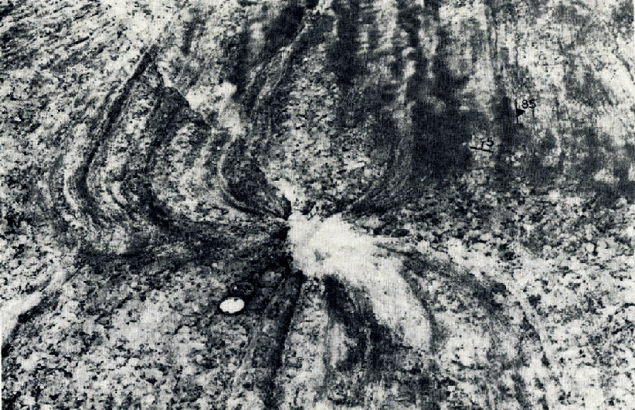
In addition to being deformed into small drag folds and offset by fractures and crevasses, both the steeply dipping and the gently dipping foliation have been distorted into confluent patterns (Fig. 11). The confluent structures are found only in the lower Burroughs Glacier and seem to be more abundant along the margins than in the center. A single structure generally does not exceed 10 m. across. Spacing between patterns may be as little as 5 m. The layers in Figure 11 are accentuated at the surface by the accumulation of silt and clay, and are separated by relatively clean coarse-grained ice 4 to 20 cm. thick. A shallow hole about 25 cm. deep has developed at the center of the pattern. This hole is absent in many of the structures. The confluent pattern has also been observed on the walls of crevasses, but the attitude of its axis, which is represented by a line joining the points of convergence of these layers at different depths, is not clear. In most cases the axis appears to dip down the foliation in a direction normal to the strike.
Confluent pattern in fine-grained foliation of the eastern tongue of Burroughs Glacier. Attitude of two systems of foliation is shown at the upper right
Very little is known yet about the overall distribution of the confluent structures, their attitude with respect to the glacier as a whole, and the degree of recrystallization which has occurred since their development.
Let us assume that the ice is a relatively homogeneous substance, and that the layers of fine crystals are merely markers. The pattern in these layers should give us some indication of the kind of deformation that has taken place. No laboratory experiments have been made on ice to determine deformation structures, but a comparison can be made with deformed clay. Reference CloosCloos (1930) and others have shown that a clay block subjected to simple compression develops two sets of shear fractures, which are orientated approximately 45° from the direction of compression and intersect one another at nearly 90°.
In a plastic material under simple compression, fractures will not occur, but a continuous deformation should take place concentrated mainly along slip planes of maximum shear stress at 45° to the direction of compression. It is possible that under large hydrostatic pressures, small sustained uniaxial compressional stresses can produce this kind of deformation in ice. If the fine-grained layers in the ice were orientated normal to the direction of compression, the layers probably would deform into a number of confluent patterns whose centers coincide with the intersections of planes of maximum shear stress. Such a pattern is illustrated in Figure 12. If the compression is not approximately normal to the layers, the layers themselves will probably act as planes of weakness, slip will occur along them and the confluent patterns will not develop. The attitude of the slip planes depends on the mechanical properties of the layers and their orientation with respect to the direction of compression. The apparent angle between slip planes as observed on the ice surface may be considerably narrower than the true dihedral angle, because the ice surface intersects the planes at an oblique angle.
Postulated attitude of typical confluent pattern in fine-grained layers, Burroughs Glacier. A-B represents line of greatest strain release

Figure 12 shows the postulated attitude of the structure as determined from patterns seen on the ice surface and on crevasse walls. The intersections of planes of maximum shear stress form a line which joins the center of the confluent pattern on the surface with that on the wall of the block. Along this line of intersection the greatest strain occurs. The attitude of this structure requires a component of compression orientated nearly normal to the dipping layers. Since the foliation parallels the walls of the valley and the direction of glacier flow, the only condition whereby a component of compression could be produced normal to the walls and foliation would be where the ice, under “compressive flow”, is prevented from expanding laterally. In the upper Burroughs Glacier the crevasses change gradually from a transverse to a splaying pattern (Fig. 4). The transition occurs within a valley constriction just before the ice expands into a broad basin. At this constriction the foliation along the margins could be compressed to form the confluent structure.
According to this hypothesis a plastic flow seems to be the chief mechanism in the development of the confluent pattern. The surficial fractures in the ice appear to be a later feature unrelated to the pattern in the layering. Only in the center of the pattern where strain release is greatest is there evidence that the ice has disintegrated. Here it is possible that the crystals were crushed, and if no extensive recrystallization occurred after the formation of the pattern, this central part would have been more susceptible to ablation once the pattern had been exposed, which may account for the shallow pits occurring at the centers of some patterns (Fig. 11). In some cases plastic flow may have been greater along one slip plane than along the other. This pattern also could be due to an offset of the original symmetrical pattern caused by later plastic flow along one of the original slip planes. Note that fractures do not coincide with this line of offset.
There is no independent evidence that this type of deformation actually can occur in ice under stresses of the order of 1 to 2 bars (personal communication from J. F. Nye); therefore, this hypothesis remains doubtful.
Tensile stresses might also form a confluent pattern in ice, since the orientations of planes of maximum shear stress are similar in tension and compression. In a glacier, however, tensile stresses can occur only within 20 to 30 m. of the upper surface (Reference NyeNye, 1957) and the available evidence suggests that the confluent patterns form at considerable depth.
A second hypothesis is that the structure may be caused by the plastic collapse of abandoned moulins (personal communications from M. F. Meier, C. Bull and W. V. Lewis). It is very possible that a moulin which has been abandoned by drainage could plastically close in at depth. In support of this idea is the fact that on Austerdalsbre, the Saskatchewan, the Burroughs and other glaciers, the layers bend in toward some of the moulins, and in addition the confluent patterns have been observed only in the lower portions of these glaciers. On the Burroughs Glacier moulins in excess of 20 m. depth do exist. In further support of the moulin hypothesis is the fact that the theoretical pattern of foliation that results from the closing of a moulin (assuming a plane problem and conservation of volume in the ice) closely resembles the observed pattern. (This idea was suggested in a personal communication from J. F. Nye.)
Coarse-Grained Border Ice
Texture
The moderately coarse-grained ice, which covers an area 0.25 to 0.50 km. wide at the eastern terminus of the glacier (Fig. 3), contains crystals from 5 to 10 cm. in diameter or larger and lacks fine-grained foliation. The grain boundaries are not as sinuous as in the foliated ice and the grains are more equigranular. The ice is unusually free of bubbles or bubble layers.
Throughout most of this marginal ice are a series of planar surfaces formed by the alignment of boundaries of coarse crystals (Fig. 13). These planes may have contained fine crystals which with subsequent recrystallization formed coarse crystals whose boundaries were aligned along the original contact between the fine-grained layer and the adjacent coarser ice. Since the distribution of these planes closely resembles the fine-grained foliation pattern up-glacier and often grades into this pattern, these structures are referred to as relict foliation on the structure map (Fig. 3).
Ice surface east of Nunatak “E”. Coarse-grained border ice with relict foliation is in the foreground. Note the distribution of debris on the surface bordering the nunatak

A size parameter for individual crystals of coarse ice on the glacier surface was determined by multiplying the long diameter by the short diameter and averaging the values of 100 crystals at each locality. This was not intended to be an absolute size measurement, but it was used as a parameter to show differences in size. Using this technique, several traverses were made from the terminus up-glacier to the foliated ice area, making measurements every 100 to 200 m. The grain-size generally decreases linearly away from the terminus and is independent of changes in local ice surface gradient.
An example of one traverse is shown in Figure 14. On an ice slope of about 4°, the coarse crystal size decreases linearly away from the terminus, but the slope of the curve changes abruptly in the area where fine-grained foliation appears (the foliated ice). (It is important to remember that in the area of foliation the fine ice was disregarded in measuring changes in grain-size, so that Figure 14 refers only to the coarse ice crystals.) The change in slope shown on the lower graph in Figure 14, which marks a sudden change in the rate at which crystal size decreases away from the terminus, may represent the gradational boundary between active and inactive ice. The ice movement may drop off very rapidly in this zone with a significant decrease in stress and increase in grain-size. The gradational change in grain-size is much too subtle to detect by direct observation.
Change in grain-size with distance from the terminus along a longitudinal profile, eastern tongue, Burroughs Glacier

In support of this hypothesis, laboratory experiments have shown (Reference HessHess, 1904, p. 31–33; Reference Tammann and DreyerTammann and Dreyer, 1929, p. 289–313; Reference BaderBader and others, 1939; Reference DemorenDemorest, 1953; Reference SteinemannSteinmann, [1956]; Reference RigsbyRigsby, 1958; Reference ShumskiyShumskiy, 1958) that grain enlargement does occur after release of stress. Reference RigsbyRigsby (1958, p. 356) found that it is most rapid at the pressure melting point. The fact that grain boundaries in the coarse ice are not as sinuous as in the foliated ice is further evidence that the coarse ice is under less stress.
Crystal orientation
Orientations of 200 crystals near the terminus were measured, about 600 m. from localities “A” and “B” (Fig. 5). The optic axis was determined by measuring with a Brunton compass the strike and dip of deeply etched grooves, “Forel’s stripes”, appearing on the exposed surface of very large crystals in situ. This method was first suggested by Reference BaderBader (1951, p. 530). When exposed to infrared radiation, the surfaces of large crystals melt out along a series of closely spaced planes which are normal to the c-axis and which represent weak bonding in the basal section of the ice crystal. The grooves are probably initiated by the coalescence of Tyndall figures within the crystal. These figures are rounded or hexagonal disks, sometimes flower-shaped if well developed, which contain water and vapor from internal melting. Reference TyndallTyndall (1858), who first described them, found that they were elongate in a preferred direction in each crystal and owed their shape to the molecular structure of the ice. Reference NakayaNakaya (1956, p. 37) demonstrated that they grow and become elongate in the plane of the a-axes, i.e. perpendicular to the c-axis in the hexagonal ice crystal, and therefore can be used to determine orientation of the optic axis. These figures must not be confused with larger more spherical air bubbles that are trapped between grains during the process of firnification and are often included within the single crystals.
Measurements of the etched basal sections and Tyndall figures with a Brunton compass can be made fairly accurately (within 5°) if extreme care is taken. An effort was made to measure as many crystals with gently dipping basal sections as possible, since these were not as well exposed. Crystals were measured in two adjoining areas approximately 10 m. square. It was impossible to measure every crystal in a specific area, for at least 50 per cent of them were not etched enough to make an accurate measurement.
The fabric diagram in Figure 5, plotted from these data, is fairly reliable. Considering the conditions under which crystals were measured, it is highly unlikely that biased selection of grains could have produced three distinct orientations. If a single maximum were present, then it might be suspected that the data represented selective sampling.
The origin of the triple-maxima fabric at the glacier terminus is not known. Some of the coarse ice fabrics derived from the Emmons Glacier (Reference RigsbyRigsby, 1951, p. 594), and the lower Blue Glacier (Reference AllenAllen and others, 1960, p. 615) resemble this triple pattern. These fabrics were obtained from the centers of glacier tongues, and many of them had four maxima in a diamond distribution.
A pattern of triple maxima has been reported by Reference SteinemannSteinemann (1958, p. 46–50) and noted by Reference KambKamb (1959, p. 1906) who measured in the laboratory a preferred orientation in ice immediately after torsion-shear deformation. He obtained two strong maxima (greater than t o per cent) and a weak one (5 to 10 per cent) centered about the pole to the shear plane. It is possible, therefore, that the triple-maxima fabric at the terminus of the Burroughs Glacier may have been produced by shear along the gently dipping foliation plane which exists farther up-glacier, or by shear near the glacier bed. If the maxima had been caused by shear, however, a similar pattern of maxima centered about the pole to this foliation plane in the coarse ice should be present at localities “A” and “B” also, but such is not the case.
Another possibility is that the three maxima are related to the maxima at locality “A”, but have been rotated. This would require individual rotation of each maximum by a different amount, which seems unlikely.
The fabric at the terminus probably has formed under conditions different from those which produced the fabric at localities “A” and “B”, for the terminal ice has come from greater depth and has travelled a greater distance than the ice at “A” and “B”. In addition, this terminal ice has been exposed recently to a relatively stress-free environment, compared with the environment at the other locality ‘B” where ice is still moving (0.5 m. in 11 months). Recrystallization may or may not have altered the fabric originally produced under stress.
Basal Ice
An intriguing feature of the glacier structures is the occurrence of debris-rich, coarse-grained ice at the glacier margin in a number of areas, particularly bordering nunataks “F” and “E” (Fig. 15), along the glacier terminus east of these nunataks, and in the Glacier Pass region (Fig. 3). The most striking characteristics are the extremely sharp contact between this very dirty ice and the much cleaner ice overlying it, and the slightly unconformable relationship between layers on both sides of the contact. In Glacier Pass, the relict foliation in the dirty ice dips 10 to 15° north-east beneath the white ice and strikes about south 40° east, while foliation in the white ice dips 5° north-east and strikes south 25° east (Fig. 3). In the Glacier Pass area there is no abrupt change in grain-size across the contact. The overall grain-size varies between 5 and 20 cm. diameter at the surface. This relationship between the two kinds of ice is similar to that in the other areas.
Aerial view of the eastern terminus of the Burroughs Glacier from 2,135 m. elevation (7,000 ft.), showing debris-rich basal ice bordering the nunataks. See Figure 3 for location. Distance of “F” from the ice edge is 0.5 km.

It seems likely that these dirty ice masses are remnants of very old ice and that the contact is an old erosion surface upon which the younger clean ice accumulated. The lack of significant difference in grain-size across all of these contacts may argue against this hypothesis, but it is possible that the stagnant ice reaches an equilibrium point where the grain-size no longer increases; the grains in the basal dirty ice and in the younger ice may have both reached the same equilibrium size and yet be of greatly differing age.
Alternatively, the basal ice may be directly related to the overlying ice, and may merely represent the bottom zone, where excessive shear has taken place along discrete planes. In this situation the debris should be concentrated along the planes. For instance, dirty ice related to basal shear is well displayed in the vicinity of nunatak “E” (Fig. 13). The upper ice directly east of this nunatak is broken by a series of gently dipping fractures containing debris which is washed down-slope as ablation progresses. This upper dirty ice is probably related to the recent flow of the Burroughs Glacier. Below this ice, however, at the very edge of the nunatak at the left of’ the photograph (Fig. 13) a distinct band of much darker ice is present. In this ice the shear planes are generally absent and the debris is concentrated along a single horizon. It is similar to the basal ice of the Glacier Pass region.
One can only speculate about the age of the basal ice. It may be a remnant of the very early stage of the Little Ice Age advance where the ice was trapped in low areas so that as the glacier grew the younger ice flowed out over the basal ice. If the ice flows plastically this should not happen. The basal ice may be so loaded with debris that its flow properties are altered so much that its ability to be squeezed out of a broad depression is inhibited.
Dirt Bands
In the lower glacier on the eastern tongue dirt bands are distinct (Fig. 6), forming a lobate pattern convex down-glacier. The bands occur at the outcrops of the fine-grained ice (Fig. 8) . The dirt does not appear below the ice surface except along a few fractures. Therefore, the dirt accumulation must have occurred over a period of decades, during which time highly disseminated particles in the ice and wind-blown particles at the surface became gradually trapped along grain boundaries as the ice wasted down.
Although the amount of dirt on the coarse ice is nearly the same as on the fine ice surface, the coarse ice looks cleaner because the dirt has been washed off the cobble-like grains and deposited along the deeply etched boundaries. Since grain boundaries are closer together in the fine ice, the dirt is distributed more evenly on this surface, thus producing a dirtier-looking ice.
Conclusions
Future investigations of ice structures in temperate glaciers should be directed toward the analysis of ice fabric at depths greater than 30 m., when thermal ice-coring drills are available. Fabric studies of glacier ice have been limited to shallow depths where the stress environment is radically different from that near the sole of the glacier. Some of the fabric studies on the Burroughs Glacier show that ice adjusts rapidly to changes in the stress field. There is evidence that stresses which caused faulting near the surface also caused a recrystallization of the ice just below the ruptured zone. Thus the fabric measured near the surface is not necessarily representative of the fabric deep in the glacier.
Optic orientations should be measured in a cold Iaboratory rather than in the field to improve accuracy and to facilitate the cutting of sections to a thickness of less than 1 mm., so that the very small crystals in fine-grained ice may be measured.
In future studies a relatively simple glacier should be chosen, such as the Athabaska Glacier, Alberta, which has recently been mapped and where motion studies (Reference PatersonPaterson, unpublished) have been made.
The use of stake patterns to measure strain-rate at the surface near the terminus was unsatisfactory because of the rapid lowering of the ice surface by ablation, and the lack of movement. Under these conditions a photogrammetric method of measuring strain-rate would perhaps be better.
Acknowledgements
Support for the preliminary field investigation in 1959 was provided by the National Science Foundation through the American Geographical Society’s glacier investigation program. The Foundation then provided support for the 1960 field season, and subsequent data reduction and analysis, through grant No. NSF-G13842 to The Ohio State University Research Foundation.
Interpretation and plotting of data were greatly facilitated by a map of the Burroughs Glacier compiled from the 1960 aerial photographs by the Department of Geodetic Science, under Project 1227 of The Ohio State University Research Foundation.
The study would not have been possible without the initial planning and strong encouragement of Dr. Richard P. Goldthwait, the advice and help of Dr. Colin Bull, Dr. Howard Pincus and Dr. William O. Field.
Dr. John Lyons (Geology Department, Dartmough College), Dr. John Nye (H. H. Wills Physics Laboratory, University of Bristol), Dr. Mark Meier (U.S. Geological Survey), Dr. Sidney White (Geology Department, The Ohio State University) and Dr. Arthur Mirsky (Institute of Polar Studies) also contributed helpful suggestions.


