




Chronology is the backbone of archaeological reconstructions, but it is also a chain of inferences and assumptions—some explicit, many tacit. In practice most chronologies in the Americas rely on culture-historical sequences derived from ceramic seriation and similarities to better studied regions, employing absolute dating and Bayesian modeling in a highly variable manner. Most users of chronologies, however, are not engaging in culture history; they interpret ceramic complexes and their associations to a circumscribed range of dates according to their own research questions often in conflict with the assumptions underlying the chronologies in the first place.
Pacific Nicaragua serves as a case in point. Compared to other regions in Mesoamerica, the region has been heavily understudied. For decades it has been subsumed within the “Gran Nicoya” tradition, an archaeological construct shaped largely by developments in northwestern Costa Rica. This framing has been convenient but constraining: convenient in its appeal to stylistic affinities—especially in polychrome ceramics—but constraining in its flattening of local cultural trajectories, conflation of temporally disjunct material, and dependence on a chronology generated largely outside of Nicaragua itself. As a result, key assumptions about ceramic phases, cultural affiliations, and the timing of events have been recycled and reinforced with little scrutiny, even as new data increasingly strain interpretations (McCafferty and Steinbrenner Reference McCafferty, Steinbrenner, Waters-Rist, Cluny, McNamee and Steinbrenner2005a; Steinbrenner and McCafferty Reference Steinbrenner, McCafferty, Steinbrenner, Geurds, McCafferty and Salgado2021).
In this article, we present a framework to build models parsimonious with both contextual and stylistic-morphological data. We begin by briefly introducing Pacific Nicaragua as a culture region, describing previous efforts at establishing a local chronology. To demonstrate how different tolerances to uncertainty affect interpretative outcomes we present a revised chronology and cultural sequence for Pacific Nicaragua built from 79 radiocarbon dates drawn from 19 sites across the region (Figure 1). Rather than rely solely on inherited sequences or heuristic typologies, we employ a Bayesian modeling framework that explicitly nests dates within both stratigraphic and stylistic contexts. This allows us to not only refine the temporal distribution of ceramic complexes, but to be transparent about the inferential scaffolding that supports those reconstructions. Importantly, we do not presume a single way of reading the chronology but rather provide a set of inferential tools—a timeline, a Gantt chart, and a stacked area diagram—appropriate for different research questions.
Map of Pacific Nicaragua indicating sites mentioned in the discussion.
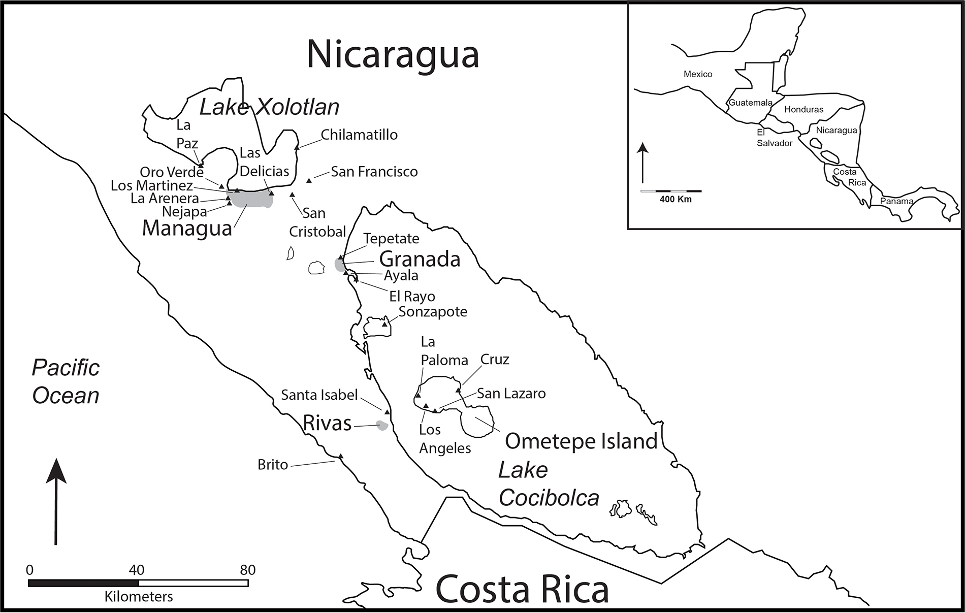
Figure 1 Long description
A map of Pacific Nicaragua highlighting various locations and sites. Key areas include Managua, Lake Xolotlan, Granada and Ometepe Island. The map also shows the Pacific Ocean to the west and the border with Costa Rica to the south. An inset map provides a broader view of the region's location within Central America, including neighboring countries like Mexico and Costa Rica. The map includes a scale in kilometers and directional arrows for orientation.
Cultural context for Pacific Nicaragua
Pacific Nicaragua has been recognized as the southern frontier of greater Mesoamerica for the past 100-plus years (McCafferty et al. Reference McCafferty, Amador, González, Dennett, Nichols and Pool2012). At contact in the early sixteenth century the native inhabitants spoke dialects of Nahuat and Oto-Manguean, both languages originating in central and southern Mexico (Constenla Reference Constenla1994). Colonial period chronicles recounted historical myths of Chorotega and Nicarao groups arriving along the Pacific coast in the centuries before the Spanish conquest, although the precise timing of the migrations remains ambiguous (Abel-Vidor Reference Abel-Vidor1980; Chapman Reference Chapman1974; Fowler Reference Fowler1989). Cultural characteristics such as the religious pantheon and practices, as well as the use of the central Mexican calendar, were reported and have been cited as evidence for the Mesoamerican nature of the colonizing groups. One element that has attracted interest has been the use of polychrome pottery with elements of the Mixteca-Puebla stylistic tradition, including iconography relating to the Mesoamerican “feathered serpent” (Day Reference Day, Nicholson and Keber1994; Lothrop Reference Lothrop1926; Manion and McCafferty Reference Manion, McCafferty and Lacayo2017; McCafferty Reference McCafferty2019; McCafferty and Steinbrenner Reference McCafferty and Steinbrenner2005b). Less obvious, however, are the cultural characteristics of the autochthonous groups that occupied the region prior to the Mexican migrations. It is likely that these were speakers of a macro-Chibchan language since Chibchan dialects are still spoken in central and eastern Nicaragua (Constenla Reference Constenla1994; Steinbrenner Reference Steinbrenner, Steinbrenner, Geurds, McCafferty and Salgado2021a). Archaeological evidence indicates interaction between these groups and Maya from El Salvador and Honduras, based on the shared use of Usulutan-like Negative Resist ceramics during the Formative period (Braswell Reference Braswell1997; Demarest and Sharer Reference Demarest and Sharer1982; Dennett et al. Reference Dennett, Platz and McCafferty2011).
Interest in this cultural dynamic of Mesoamerican contact in Pacific Nicaragua has generated much research, especially in the past 25 years, including an intensive research program based at the University of Calgary (McCafferty Reference McCafferty, Steinbrenner, Geurds, McCafferty and Salgado2021). Results from excavation projects at several major sites along the shore of Lake Cocibolca, as well as from other projects, have greatly enhanced knowledge of the pre-Columbian occupation of the region, albeit with mixed results as to the nature of Mesoamerican integration (McCafferty Reference McCafferty, Anderson, Clark and Anderson2015). Some characteristics, such as the polychrome imagery, strongly suggest contact, whereas other elements argue against Mexican culture. For example, evidence of ancient foodways does not indicate an important role for staples such as maize, dog, or turkey in the diet. As is typical of archaeological reconstructions, with more evidence interpretations become more complex, and more research is always needed to clarify inconsistencies.
An overarching problem with interpretation is the question of the “Greater Nicoya” culture area, a concept introduced in the 1960s (Lange Reference Lange, Lange and Stone1984, 1992–1993; Norweb Reference Norweb1964; Steinbrenner Reference Steinbrenner, Steinbrenner, Geurds, McCafferty and Salgado2021b). As initially presented, Greater Nicoya included Pacific Nicaragua and northwestern Costa Rica and was considered the Mesoamerican frontier (Coe Reference Coe1962; Creamer Reference Creamer1989). Similarities in the polychrome pottery were interpreted as evidence of a homogeneous cultural tradition, especially during the Postclassic period. Recently, a comparative analysis of ceramics from the Nicoya peninsula of Costa Rica and sites along the shore of Lake Cocibolca in Nicaragua have demonstrated considerable differences. These, plus significant variations in settlement and mortuary patterns call into question the utility of the “Greater Nicoya” model (Ibarra Rojas Reference Ibarra Rojas, Steinbrenner, Geurds, McCafferty and Salgado2021).
The existing chronology for Greater Nicoya was developed using primarily Costa Rican data in the early 1990s (Bonilla et al. Reference Bonilla, Calvo, Guerroro, Salgado and Lange1990; Vásquez et al. Reference Vázquez Leiva, Lange, Hoopes, Zamora, González, Quirós, Bishop, Borgnino, Umaña, Ulloa, Pérez, Fletcher, Miranda, Lauthelin, Rigat, González and Galeano1994) with relatively little input from Nicaragua. Archaeological investigations over the past 30 years, however, have generated 79 useable radiocarbon dates relating to well-documented archaeological contexts. For this reason, we believe that a reconsideration of regional chronologies is relevant, with Pacific Nicaragua considered separately from the cultural traditions of southern “Greater Nicoya.”
Chronological considerations
The archaeology of Nicaragua has a relatively long history, stretching back into the mid-1800s with North American and European explorers visiting pre-Columbian sites and sending back descriptions as well as actual artifacts (Bovallius Reference Bovallius1886; Bransford Reference Bransford1881; Squier 1993[Reference Squier1853]; Whisnant Reference Whisnant1995). They took particular note of the beautiful polychrome pottery, which led to interpretations of long-distance interaction with cultures from Central America and Mexico. In 1926, Samuel Lothrop published two volumes on the ceramics of Nicaragua and Costa Rica, including color plates of the vibrant iconography. Comparisons with pottery from other regions allowed a relative sequence of the different styles while suggesting cultural interactions.
The first formal chronology was suggested in 1961 by Michael Coe and Claude Baudez based on their excavations in northwestern Costa Rica (Geurds Reference Geurds and Lacayo2017). They divided the cultural sequence into four periods: Zoned Bichrome, Early Polychrome, Middle Polychrome, and Late Polychrome. Specific time periods were suggested in a subsequent publication (Baudez and Coe Reference Baudez and Coe1962), roughly correlating these periods with those of the Maya region. This chronology continued to be used into the 1990s, when a conference on Greater Nicoya archaeology presented 90 radiocarbon dates that were used to suggest a new chronological terminology (Vázquez et al. Reference Vázquez Leiva, Lange, Hoopes, Zamora, González, Quirós, Bishop, Borgnino, Umaña, Ulloa, Pérez, Fletcher, Miranda, Lauthelin, Rigat, González and Galeano1994):

This sequence is still in use, both in Costa Rica and Nicaragua, although the diagnostic ceramics used to identify the different periods vary by region (Niemel et al. Reference Niemel, Román Lacayo, González, Laporte and Escobedo1998). Due to the abundance of absolute dates from northwestern Costa Rica, plus the large number of Costa Rican archaeologists involved in the conference, the period names were generally taken from Costa Rica with little reference to archaeological contexts.
In addition to these overarching chronological sequences, several scholars suggested more localized sequences to better fit the excavated data from Pacific Nicaragua. For example, Wolfgang Haberland (Reference Haberland, Lange, Sheets, Martinez and Abel-Vidor1992), suggested a local sequence for Ometepe Island, as did Paul Healy (Reference Healy1980) for the Rivas region and Silvia Salgado (Reference Salgado González1996a; Salgado González and Zambrana Fernández Reference Salgado Gonzalez and Fernandez1994) for Granada.
Haberland and Paul Schmidt investigated 10 sites on Ometepe Island (in Lake Cocibolca) during the early 1960s (Haberland Reference Haberland, Lange, Sheets, Martinez and Abel-Vidor1992). Based on comparisons with the material culture of Costa Rica and several radiocarbon dates, nine phases were suggested for the Ometepe sequence: Dinarte (2000–500 b.c.); Angeles (800–300 b.c.); Sinacapa (200 b.c.–a.d. 1); Manantial (a.d. 1–500); San Roque (a.d. 500–950); Gato (a.d. 1000–1200); La Paloma (a.d. 1100–1300); San Lazaro (a.d. 1300–1400); and Santa Ana (a.d. 1400–1550). Interestingly, Haberland (Reference Haberland, Lange, Sheets, Martinez and Abel-Vidor1992:115–116) mentioned that the culture history of Ometepe included elements from both northern and southern sectors of Greater Nicoya, as well as additional unrelated characteristics. Especially for the final Santa Ana phase, he cited Ciudad Real’s sixteenth-century account that the inhabitants spoke neither Chorotega nor Nicarao languages.
Healy (Reference Healy1980:296) used a seriation analysis of 80,000 sherds, which were classified into 40 different types and varieties. He related his chronology for the Rivas region to the sequence suggested by Baudez and Coe (Reference Coe1962), but subdividing each period into two phases. For example, the Zoned Bichrome period was divided into Aviles and San Jorge phases; the Early Polychrome period was divided into the San Roque and Palos Negros phases; the Middle Polychrome period was divided into the Apompua and La Virgen phases; and the Late Polychrome period was divided into the Las Lajas and Alta Gracia phases. Healy correlated these phases with 39 radiocarbon dates from the Greater Nicoya region, only nine of which came from sites in Pacific Nicaragua (1980:305).
Silvia Salgado conducted a settlement pattern survey of the Granada region for her PhD research (Reference Salgado González1996a), with excavations at the site of Ayala (Reference Salgado González and Lange1996b). Based on her research—especially from excavated contexts—she subdivided the Bagaces period into three phases: the Siu phase (a.d. 300–500), the San Antonio phase (a.d. 500–650), and the Ayala phase (a.d. 650–800/900). Otherwise, the Granada chronology followed the “new” sequence proposed by Vázquez et al. (Reference Vázquez Leiva, Lange, Hoopes, Zamora, González, Quirós, Bishop, Borgnino, Umaña, Ulloa, Pérez, Fletcher, Miranda, Lauthelin, Rigat, González and Galeano1994).
These specific phases are useful for interpreting local developments, but may complicate cross-regional comparisons, particularly because they continued to rely on southern (i.e., Costa Rican) dates and diagnostics. A significant challenge to that sequence was presented by McCafferty and Steinbrenner (Reference McCafferty, Steinbrenner, Waters-Rist, Cluny, McNamee and Steinbrenner2005a) when, based on the Santa Isabel excavations, it was found that many of the alleged Ometepe period decorated types were introduced several centuries earlier, during the Sapoá period. In a recent chapter, Steinbrenner and McCafferty (Reference Steinbrenner, McCafferty, Steinbrenner, Geurds, McCafferty and Salgado2021) even argue that virtually all the radiocarbon dates associated with Ometepe period contexts are either too early for the traditional time range or are of dubious affiliation. Consequently, they suggest some potential diagnostic ceramics types but cannot identify any archaeological sites from the late period with adequate investigation. This is particularly perplexing since this would be the period associated with the majority of the ethnohistorical evidence suggesting Mesoamerican influences.
Since 1990, the amount of archaeological research in Pacific Nicaragua has increased dramatically. Frederick Lange (Reference Lange1995, Reference Lange1996, Reference Lange, Steinbrenner, Geurds, McCafferty and Salgado2021) directed several salvage projects in the Managua metropolitan zone. Settlement pattern studies have been conducted in Rivas, Masaya/Tisma, and Granada (Niemel Reference Niemel2003; Niemel Garrard Reference Niemel Garrard, Steinbrenner, Geurds, McCafferty and Salgado2021; Román Lacayo Reference Román Lacayo2013; Salgado González Reference Salgado González1996a). Large projects have been conducted by researchers from the University of Calgary (McCafferty Reference McCafferty, Steinbrenner, Geurds, McCafferty and Salgado2021), Leiden University (Donner et al. Reference Donner, Arteaga, Geurds and van Dijk2018), Saitama University (Hasegawa Reference Hasegawa2018; Hasegawa et al. Reference Hasegawa, Zambrana, Solano and Zambrana2019), SUNY Plattsburgh, and California State University at Long Beach, often in collaboration with archaeologists from the National University of Nicaragua in Managua (Lechado and Balladares Navarro Reference Lechado and Sagrario2016, Reference Lechado and Navarro2019), the Nicaraguan Institute of Culture (Moroney Ubeda Reference Moroney Ubeda2011; Zambrana Fernández Reference Zambrana Fernández2012), and the municipality of Managua (Espinoza Perez et al. Reference Espinoza Perez, Obando, Garcia and Caceres2023).
Dated archaeological contexts
Archaeological excavations since 1960, and especially over the past 20 years, have generated 79 radiocarbon dates that warrant a new effort to develop a region-specific chronology for Pacific Nicaragua. We list the available radiocarbon dates in Table 1 and describe their contexts briefly in the following paragraphs. Where possible this includes figures with Harris matrices and specific radiocarbon dates; for other sites with limited information the dates are included as Supplementary content. It must be emphasized that the quality of the reported data varies, especially for some of the older studies for which limited information was available as to contexts and associated material culture. Following this section, we suggest a new chronology specific to the region.
Radiocarbon dates from Pacific Nicaragua
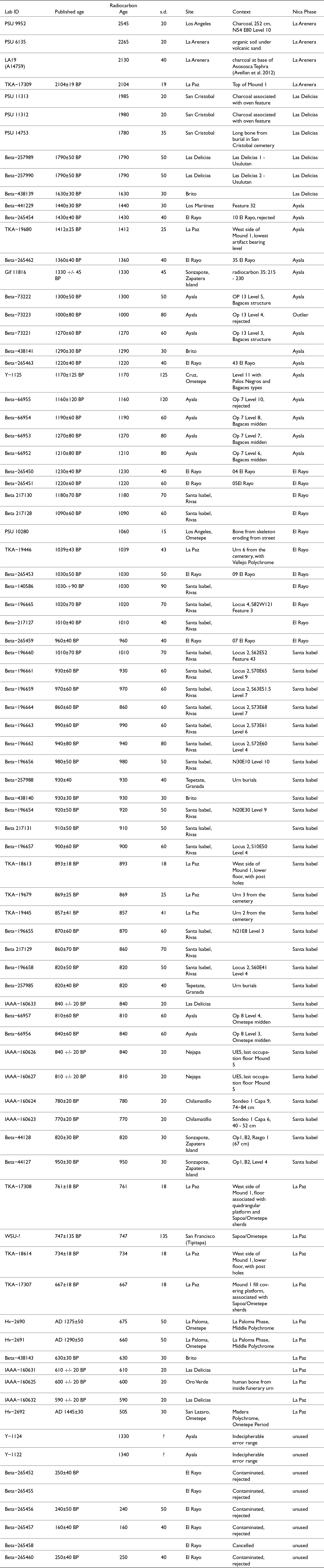
Table 1 Long description
The table presents radiocarbon dating results from various archaeological sites in Pacific Nicaragua, detailing ages from 2545 to 160 years before present (BP). Key sites include La Arenera, San Cristobal, and El Rayo, each associated with specific archaeological contexts such as charcoal layers, burial sites, and midden deposits. The data is categorized by Nica Phase, with La Arenera and Las Delicias phases showing older dates, while Ayala and Santa Isabel phases reflect more recent periods. Some entries, like those from El Rayo, are noted as contaminated or rejected, indicating potential issues with sample integrity. The table highlights the chronological spread of human activity and cultural phases in the region, though some data points lack published ages or have been marked as outliers.
Ayala (Granada, Gr 2)
The Ayala site is located near the base of the Mombacho volcano in the Department of Granada. It was initially sampled by Albert Norweb in 1961 but was more extensively investigated by Silvia Salgado González (Reference Salgado González1996a) during her regional survey. Salgado subsequently excavated the site, revealing Bagaces and Sapoá period occupations (Salgado González Reference Salgado González and Lange1996b:437; Salgado González and Zambrana Fernández Reference Salgado Gonzalez and Fernandez1994).
Eleven total radiocarbon dates are available from Ayala. Unfortunately, those reported by Haberland (Reference Haberland, Taylor and Meighan1978:405) do not have decipherable error ranges. Two other dates pertain to what was interpreted as an Ometepe period midden in Op. 8, with radiocarbon ages of 840±60 and 810±60 BP, dates more consistent with the Sapoá period (Op. 7). Of the remaining seven dates, four came from a Bagaces midden and three came from a Bagaces structure (Op. 13). Sequences can be generated for all three operations, although one of the upper two dates from Op. 13 is out of stratigraphic order (Figure 2). Two additional dates were rejected because of suspected contamination.
Dated contexts at Ayala: (left) stratigraphic relations; (right) calibrated and modeled probability distributions.
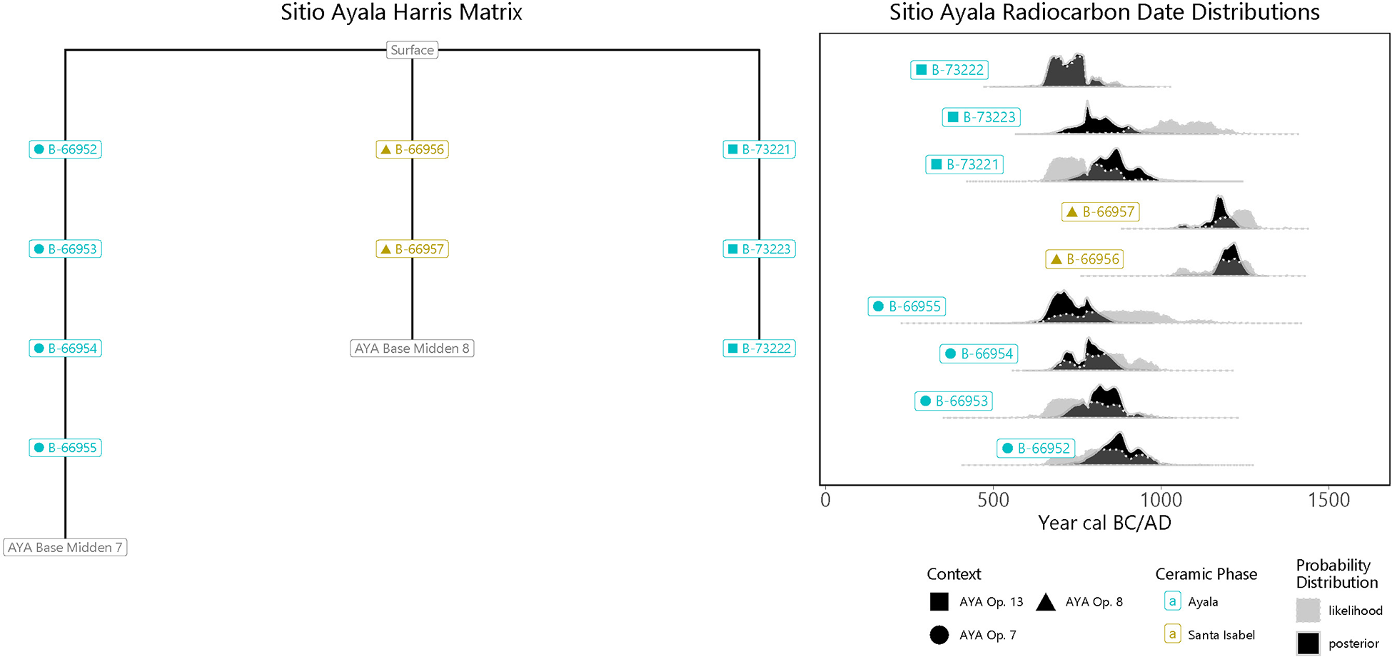
Figure 2 Long description
The image consists of two diagrams. The left diagram is titled 'Sitio Ayala Harris Matrix' and shows a hierarchical structure with nodes labeled A-62065, A-62066, A-62067, A-62068, A-62069, A-62070 and A-62071. The right diagram is titled 'Sitio Ayala Radiocarbon Date Distributions' and features a series of horizontal probability distributions plotted against a timeline labeled 'Year cal BC/AD'. Each distribution is associated with a specific label: A-62065, A-62066, A-62067, A-62068, A-62069, A-62070 and A-62071. The context legend indicates different ceramic phases and probability distribution types, including 'Santa Isabel' and 'Pueblo'.
Brito
Brito was discovered during the preliminary survey in advance of the proposed Trans-Oceanic canal. It is located on the Pacific coast north of San Juan del Sur. A brief excavation was conducted by the National Autonomous University of Nicaragua (UNAN) that identified possible salt-making activities in the low-lying mangrove swamp (Lechado and Balladares Navarro Reference Lechado and Sagrario2016). Four dates were reported, with radiocarbon ages spanning 630 to 1630 BP years (supplementary material:Figure S1) but no detailed analysis of the materials has been presented.
Chilamatillo (Managua, N-MA-8-100)
The site of Chilamatillo is located on the shore of Lake Xolotlan, in the municipality of Tipitapa. A test pit was excavated in 2017. The great majority of ceramic fragments dated to the Sapoá/Ometepe periods (Hasegawa Reference Hasegawa2018). Two radiocarbon dates are reported in sequence of each other, with very closely similar radiocarbon ages of 770 and 780 years BP (supplementary material:Figure S2).
Cruz (Ometepe Island, Ri-7)
A deeply stratified site on the east side of Ometepe Island, south of Puerto de Gracia. According to Norweb’s notes in Healy (Reference Healy1980:65–73), the Cruz site had Postclassic (Sapoá) materials above Zoned Bichrome (Bagaces) deposits in Levels 11 and 12. One date was reported: 1170±125 BP (supplementary material:Figure S3).
El Rayo (Gr-39)
El Rayo is located on the Asese peninsula into Lake Cocibolca at the base of the Mombacho volcano, in the Department of Granada. It was first identified by Salgado in her settlement survey of Granada (Salgado González Reference Salgado González1996a) but was further exposed by road construction that cut through a small cemetery at the base of a rock outcrop. Five field seasons between 2009 and 2021 encountered Bagaces and Sapoá period deposits (McCafferty Reference McCafferty, Steinbrenner, Geurds, McCafferty and Salgado2021; McCafferty and Dennett Reference McCafferty and Carrie2013). Nine loci have been identified, including cemeteries, civic-ceremonial structures, and an extensive midden deposit. Current interpretation is that El Rayo served as a necropolis for the region (McCafferty et al. Reference McCafferty, Waters-Rist, McCafferty, Fricker, Manion, Steinbrenner, Geurds, McCafferty and Salgado2021).
Radiocarbon dates have been recovered from Locus 1, a stratified cemetery with Sapoá period urn burials over Bagaces period primary direct burials, and at Locus 2 where dates have been obtained from deeply stratified midden deposits (Figures 3 and 4). Four usable radiocarbon ages range from 960 to 1230 BP. Material culture associated with these dates, especially ceramics, indicate that the transition between the Bagaces and Sapoá period occurred about a.d. 840 (Figure 5). The ceramics changed dramatically across this transition, suggesting significant and rapid culture change (McCafferty and Dennett Reference McCafferty and Carrie2013).
Dated contexts at El Rayo: (left) stratigraphic relations; (right) calibrated and modeled probability distributions.
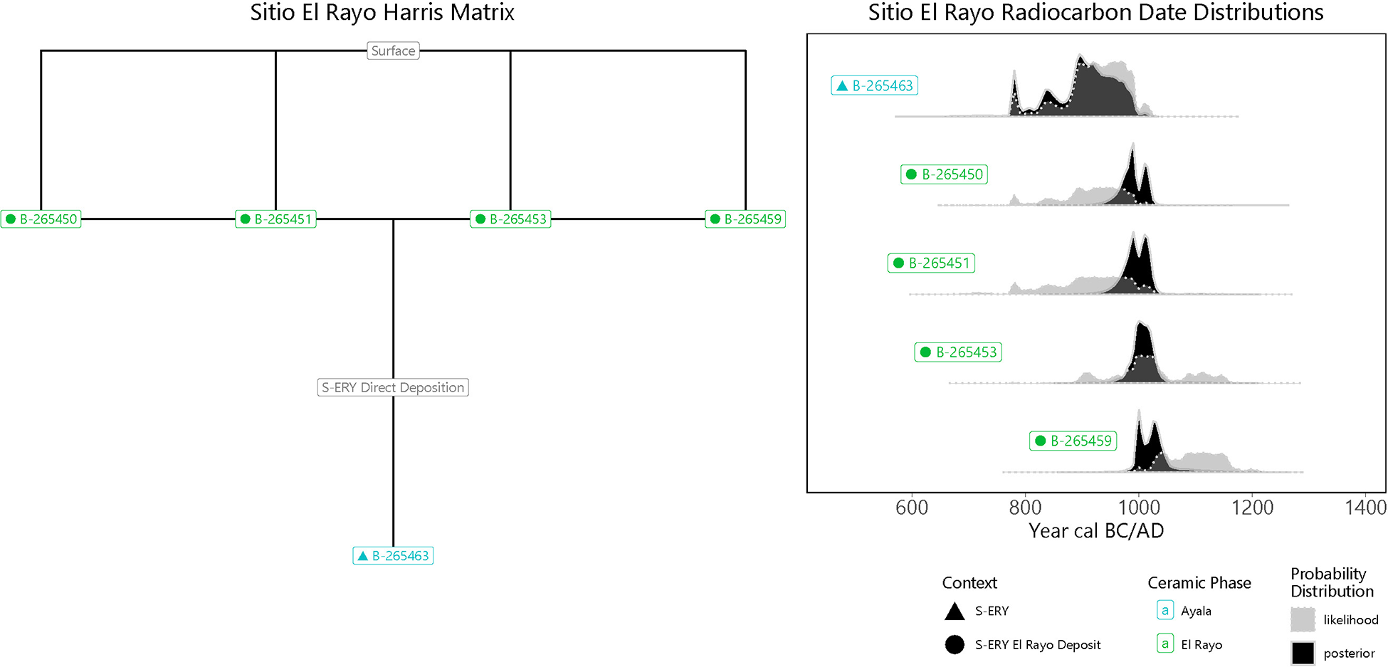
Figure 3 Long description
The left diagram is labeled 'Sitio El Rayo Harris Matrix' and shows a stratigraphic relationship with a surface layer and a direct deposition layer labeled 'S 107 Direct Deposition'. It includes radiocarbon dates labeled A 2 subscript 126451, A 2 subscript 126452 and A 2 subscript 126453. The right diagram is labeled 'Sitio El Rayo Radiocarbon Date Distributions' and presents four probability distribution curves for radiocarbon dates. Each curve is associated with a specific date: A 2 subscript 126451, A 2 subscript 126452, A 2 subscript 126453 and A 2 subscript 126454. The x-axis is labeled 'Year cal BC/AD' ranging from 600 to 1400. The probability distributions are shown with shaded areas indicating different contexts: S EF, El Rayo Deposit and El Rayo. Symbols used include triangles for S EF and circles for El Rayo Deposit and El Rayo. The probability distribution is marked as 'posterior'.
El Rayo, Locus 2, Operation 1 deeply stratified excavation showing transition from Sapoá materials over Bagaces materials.
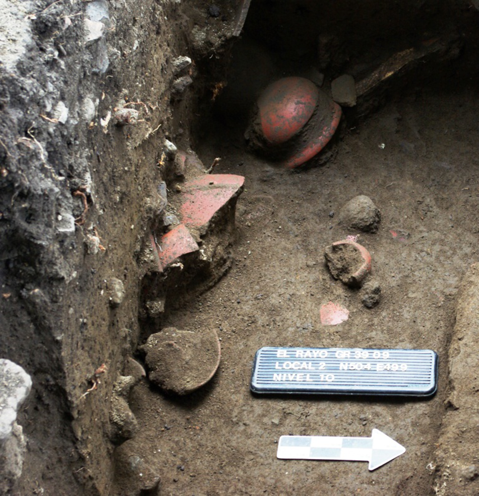
Figure 4 Long description
An archaeological excavation site displays pottery fragments partially embedded in the soil. A labeled marker reads 'El Rayo OP 3-09 Locus 2 N84 E48 Level 10'. An arrow points to the right, indicating direction or orientation. The surrounding soil appears compacted, with various small stones and debris visible.
Ceramic frequencies with radiocarbon dates from El Rayo, Locus 2, Operation 1.
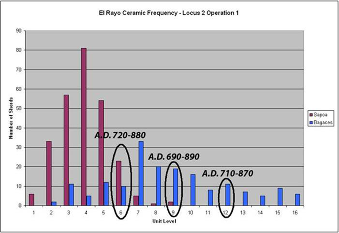
Figure 5 Long description
A bar graph titled 'El Rayo Ceramic Frequency - Locus 2 Operation 1' displays ceramic frequencies across different unit levels. The x-axis is labeled 'Unit Level', ranging from 1 to 16. The y-axis is labeled 'Number of Vessels', ranging from 0 to 80. Two types of ceramics are represented: Sapoá and Bagaces. Sapoá ceramics are shown in one color, while Bagaces ceramics are in another. Three date ranges are marked: A.D. 720-880 at unit levels 4 to 7, A.D. 690-890 at unit levels 8 to 11 and A.D. 710-870 at unit levels 12 to 15. The graph indicates varying frequencies of ceramics across these unit levels, with Sapoá ceramics showing higher frequencies in certain levels compared to Bagaces ceramics.
La Arenera (Managua)
La Arenera is a site on the outskirts of Managua that was covered by a thick deposit of volcanic sand (McCafferty Reference McCafferty2009). An extensive surface collection and several small test pits recovered artifacts associated with the living surfaces at the time of the eruption, including ceramic vessels broken in situ. Dennett et al. (Reference Dennett, Platz and McCafferty2011) published on the compositional analysis of the Negative Resist pottery.
Volcanological investigation by Pardo and colleagues (Pardo et al. Reference Pardo, Macías, Giordano, Cianfarra, Scolamacchia and Bellatreccia2009) identified the Asososca maar as the source of the volcanic sand that covered La Arenera and obtained a radiocarbon age of 1245±125 BP from a paleosol below the sand layer. Rausch and Schmincke (Reference Rausch and Schminke2010) accepted a recent date for tephra emplacement (∼1000 BP), noting the presence of Usulután pottery below the sand, but they link it to the Nejapa maar rather than Asososca. Avellán et al. (Reference Avellán, Macias, Pardo, Scolamacchia and Rodriguez2012) provided additional support for the interpretation that Asososca was the source vent and reported a more reliable radiocarbon age of 2130±40 BP obtained from charcoal from the base of the deposit (supplementary material:Figure S4). During his own recent work (Neff et al. Reference Neff, Lange, Kooistra, Caro and Rankle2019), Neff generated two radiocarbon dates on an organic-rich layer lying directly below the volcanic sand, the uppermost of which accords well with the 2130±40 BP date of Avellán et al. (Reference Avellán, Macias, Pardo, Scolamacchia and Rodriguez2012). In our model, we place this recent date from the top of the paleosol below the sand (PSU-6135) as earliest in a sequence with Avellán’s charcoal date, which represents a tree growing at the time of the eruption. The recent radiocarbon dates agree perfectly with the Usulután-dominated ceramic assemblage found by McCafferty (Reference McCafferty2009), Espinoza Perez et al. (1998) and Neff et al. (Reference Neff, Lange, Kooistra, Caro and Rankle2019) on the surface underlying the tephra.
La Paloma (Ometepe Island. OM 2)
La Paloma (OM 2) is located on the west end of Ometepe Island, just south of the town of Moyogalpa. Haberland (Reference Haberland, Lange, Sheets, Martinez and Abel-Vidor1992) worked at the site in 1962–1963 and reported remains pertaining to the Zoned Bichrome through Middle Polychrome periods. Two radiocarbon dates (supplementary material:Figure S5) pertain to the Middle Polychrome period, called the La Paloma Phase (a.d. 1100–1300) by Haberland (Reference Haberland, Lange, Sheets, Martinez and Abel-Vidor1992).
La Paz (Mateare)
The La Paz site is located on the shore of Lake Xolotlan, at the foot of the Chiltepe Peninsula, in the Mateare municipality. A mound was excavated, as well as a cemetery and additional test pits (Hasegawa et al. Reference Hasegawa, Zambrana, Solano and Zambrana2019). Nine dates are reported, including five in relative sequence from the interior of the mound and three from the cemetery. The dates range in age from 2104 to 667 BP; three of the dates form a tight cluster between 761 and 667 years BP (Figure 6).
Dated contexts at La Paz: (left) stratigraphic relations; (right) calibrated and modeled probability distributions.
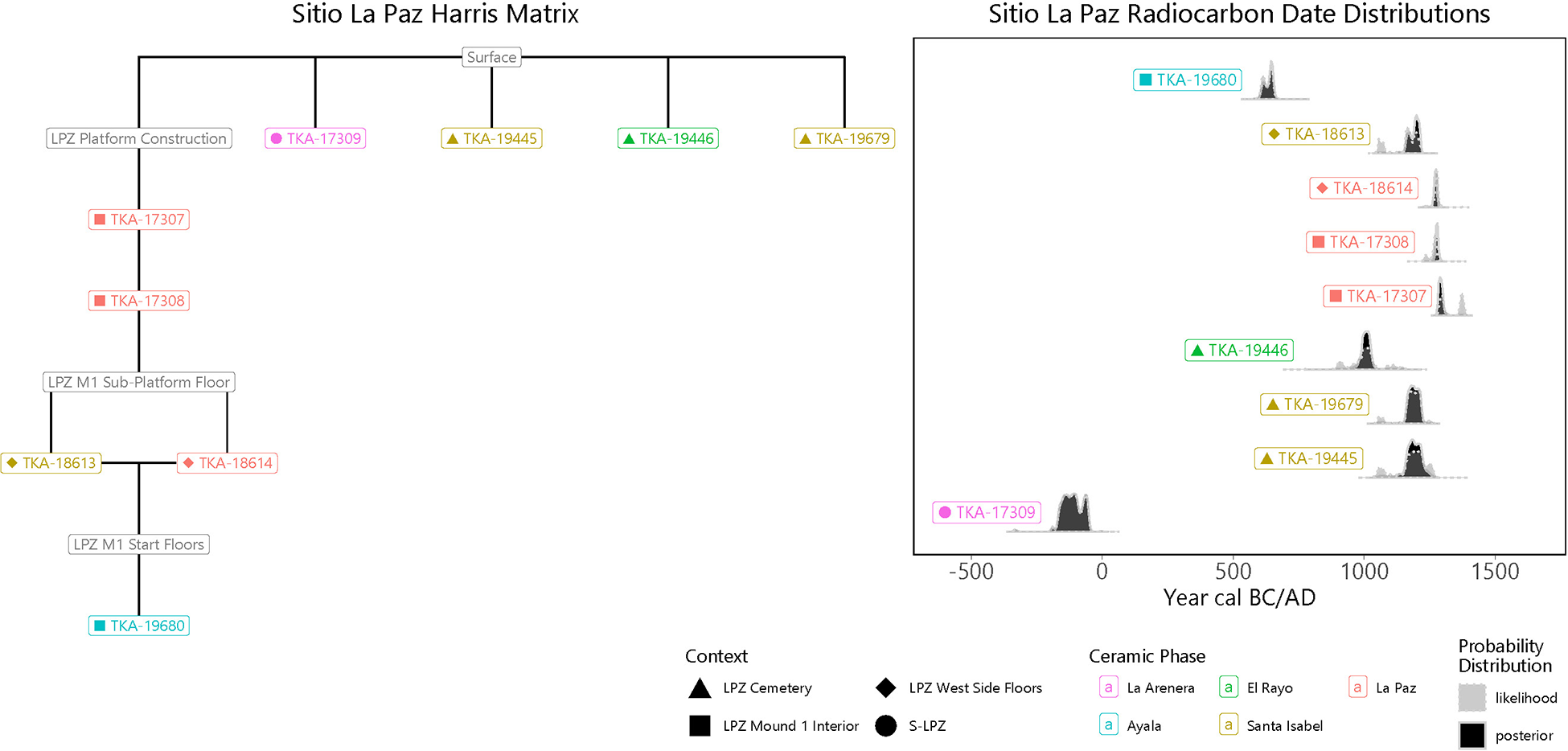
Figure 6 Long description
The image consists of two diagrams. The left diagram is titled 'Sitio La Paz Harris Matrix' and shows a hierarchical structure with nodes labeled with different contexts such as 'LPE 2 Modern Construction', 'LPE 2 Site Platform Floor' and 'LPE 2 San Floor'. Each node is connected by lines, indicating relationships between them and is associated with specific labels like 'TDA 17983', 'TDA 17984' and 'TDA 17985'. The right diagram is titled 'Sitio La Paz Radiocarbon Date Distributions' and features a series of probability distribution graphs plotted against a timeline labeled 'Year cal BC/AD'. Each graph is associated with labels such as 'TDA 17983', 'TDA 17984' and 'TDA 17985' and is marked with different symbols representing contexts like 'LPE 2 Cemetery' and 'LPE 2 West Side Room'. The x-axis represents the year in BC/AD and the y-axis represents probability. Ceramic phases are indicated with labels like 'L. Archaic', 'L. Apopa' and 'Santa Isabel'.
Las Delicias (Managua)
Located within the city of Managua, near the shore of Lake Xolotlan, Las Delicias was excavated as a rescue project by archaeologists from the Patrimony office and Mi Museo (Moroney Ubeda Reference Moroney Ubeda2011; Pavón Sanchez Reference Pavón Sanchez2008, Reference Pavón Sanchez2009). Although much of the site was destroyed during housing construction, numerous burials were rescued along with associated grave goods suggesting a Late Tempisque date. A second field season occurred in 2014 as the housing development continued. Again, Late Tempisque period burials were encountered, as well as another area that included a house mound with a ring of post holes, associated with later period ceramics. Two radiocarbon ages cluster at 1790 BP and relate to the earlier occupation, while two others clustering around 700 BP relate to the later occupation (supplementary material:Figure S6).
Los Ángeles (Ometepe Island, OM 9, N-RI-MO-003)
Haberland (Reference Haberland1986, Reference Haberland, Lange, Sheets, Martinez and Abel-Vidor1992) defined an Early Formative phase called Dinarte based on deeply buried ceramics he encountered during excavations at Los Ángeles in 1962–1963. He later compared the small collection of Dinarte Phase ceramics to the Early Formative Tronadora Phase ceramics of the Arenal región of Costa Rica (Hoopes Reference Hoopes1994). In 2021, Neff and Brown (Reference Neff and Brown2022) led an effort to resample the early deposits that met with only equivocal success in that no radiocarbon samples were found in association with the few possible Dinarte Phase sherds. However, one sample was obtained from a deep context associated with Los Ángeles Phase (early Tempisque Period) diagnostics (supplementary material:Figure S7). In addition, one date on human bone was obtained from a skeleton that was found eroding from a street in the modern town of Los Ángeles in 2010. Ceramics from the latter context pertained to the Sapoá Period.
Los Martinez (Managua)
A large site on the outskirts of the Managua urban center was excavated to salvage information prior to residential development. This was a multicomponent site with occupations during the Tempisque, Bagaces, and Sapoá periods (Zambrana Fernández Reference Zambrana Fernández2012). A single date was recovered from Feature 32, a stone walkway, which yielded a radiocarbon age of 1440±BP.
Nejapa (Managua)
Nejapa is a site overlooking Managua, excavated by the National University of Nicaragua (Managua). The site featured architectural remains as well as burials (Lechado and Balladares Navarro Reference Lechado and Navarro2019). Two dates from the last occupation floor of Mound 5 are reported, one 840±20 BP and one 810±20 BP. In a more recent project, Neff et al. (Reference Neff, Rankle, Marin-Flores, Perez, León Obando, Obando, Thakar and Brown2024) reported four additional dates from an excavation placed adjacent to a machine-dug trench through the site. These new dates came from Level 3 (855±15 BP), Level 4 (845±15 BP), Level (970±15 BP), and Level 7 (895±20 BP) (Figure 7).
Dated contexts at Nejapa: (left) stratigraphic relations; (right) calibrated and modeled probability distributions.
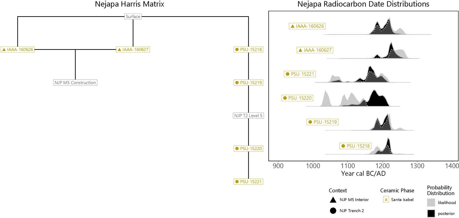
Figure 7 Long description
The image consists of two parts. The left part shows the Nejapa Harris Matrix, illustrating stratigraphic relationships with labeled nodes: NP-AMS Consultation, NP Level 5, NP Level 6 and NP Level 7. The right part displays Nejapa Radiocarbon Date Distributions with five probability distribution graphs labeled as WAK-160027, PSU-1201, PSU-1202, PSU-1203 and PSU-1204. The x-axis is labeled 'Year cal BC/AD' ranging from 900 to 1400. Each graph shows probability distributions with different shading for context and ceramic phases, including NP-05 Mound 5a, NP-05 Mound 5b and NP Trench 2. The probability distributions are marked as 'posterior' and 'likelihood.'.
Oro Verde (Ciudad Sandino)
A single date was recovered from human bone found within a burial urn. It yielded a radiocarbon age of 600±20 BP.
San Cristobal (Managua)
Located near the Managua airport, San Cristobal was initially excavated by Susan Wyss in the 1980s, when she found a Sapoá/Ometepe period occupation (Wyss Reference Wyss1983). In 2021, a housing project encountered deeply buried cemetery remains from the Late Tempisque period (Espinoza Peréz et al. Reference Espinoza Perez, Obando, Garcia and Caceres2023). An AMS date of 1780±35 BP (supplementary material:Figure S8) was recently obtained from a fragment of a long bone from one of the burials. The mechanized excavation also exposed an oven feature some distance from the burials, from which two almost identical dates of 1980±20 and 1985±20 BP were obtained and combined into a single observation in our model. The oven feature appeared to be in a slightly lower stratigraphic context from the cemetery, but we do not model the three dates as a sequence here because of uncertainties related to mechanized disturbance of the whole area. Like the burials, the feature had Late Tempisque period pottery in association.
San Francisco (Tipitapa)
A single date was reported from the San Francisco site, near the shore of Lake Cocibolca (Wyckoff Reference Wyckoff1976): 747±135 BP.
San Lazaro (Ometepe Island)
San Lazaro (OM 16) is located on the southern coast of the Concepción half of Ometepe Island. Haberland (Reference Haberland, Lange, Sheets, Martinez and Abel-Vidor1992) excavated a test pit at the site in 1962–1963, which indicated the site pertains exclusively to the late Middle Polychrome period (Haberland’s San Lazaro Phase), dated a.d. 1300–1400. The date obtained from the site, 505±50 BP, falls slightly outside of this time range.
Santa Isabel (Ri-44)
Santa Isabel is a site on the western shore of Lake Cocibolca, in the Department of Rivas. It was first sampled by Willey and Norweb in the late 1950s/early 1960s (Healy Reference Healy1980), and in the 1990s it was surveyed by Niemel, who also conducted small scale excavations (Niemel Reference Niemel2003; Niemel Garrard Reference Niemel Garrard, Steinbrenner, Geurds, McCafferty and Salgado2021). The most extensive excavations were carried out by the University of Calgary between 2000 and 2005 (McCafferty Reference McCafferty2008, Reference McCafferty, Steinbrenner, Geurds, McCafferty and Salgado2021; McCafferty and Steinbrenner Reference McCafferty and Steinbrenner2005b; Steinbrenner Reference Steinbrenner2010). These included sampling of six low mounds, primarily residential, and recovering numerous burial urns. Notably, Santa Isabel contributes 18 radiocarbon dates, of which all but three have sufficient associated information from Loci 1 and 2 to reconstruct stratigraphic relationships (Steinbrenner Reference Steinbrenner2010:196–225). The dates range from 1180 to 820 BP, but with the greatest concentration between 930 and 820 BP (Figure 8). There was also a faint trace of Tempisque and Bagaces material culture in deep levels. A stratigraphic pit into Mound 3 reached sterile soil at about 2 meters below surface (Figure 9). Seriating the diagnostic pottery by 10 cm-excavation levels it was found that the deepest levels had only Papagayo Polychromes, with other types such as Bramadero Polychrome, Granada Polychrome, Madeira Polychrome, Pataky Polychrome, and Vallejo Polychrome found in upper levels.
Dated contexts at Santa Isabel: (left) stratigraphic relations; (right) calibrated and modeled probability distributions.
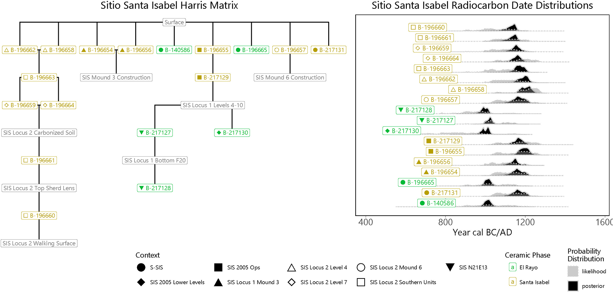
Figure 8 Long description
The image consists of two diagrams. The left diagram is titled 'Sitio Santa Isabel Harris Matrix' and displays a hierarchical structure with various labeled nodes, such as 'SS 1 1180 BP' and 'SS 2 930 BP', connected by lines indicating stratigraphic relationships. The right diagram is titled 'Sitio Santa Isabel Radiocarbon Date Distributions' and features a series of horizontal probability distribution graphs aligned with a timeline labeled 'Year cal BC/AD' ranging from 400 to 1600. Each graph corresponds to a specific context, such as 'SS 1 1180 BP' and shows a distribution curve. The bottom legend indicates symbols for different contexts and ceramic phases, including circles, triangles and squares, with labels like 'SS 1/2 Lower Level 1' and 'Bagaces'.
Santa Isabel, Locus 3 deeply stratified excavation showing superimposed floor level deposits.
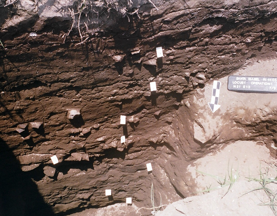
Figure 9 Long description
The image shows a stratified excavation site with multiple layers of soil visible. Small labels are placed at various points along the layers, indicating specific areas of interest. A measuring scale with alternating black and white sections is positioned vertically on the right side, providing a reference for depth. The soil layers vary in texture and composition, suggesting different historical deposits. The area is partially shaded, with some sunlight illuminating the lower right section.
Sonzapote (Zapatera Island)
Sonzapote is known from Bovallius (Reference Bovallius1886) for monumental sculpture found in association with a cluster of architectural platforms. Excavations were conducted to date the site (McCafferty et al. Reference McCafferty, Pavón Sanchez and Galeano Rueda2013). Two components were identified: an earlier occupation related to mound construction and associated with Late Tempisque/Early Bagaces ceramics, and a second component of Sapoá/Ometepe period burial urns associated with Castillo Engraved pottery but minimal polychrome. The short field season concentrated on Mound 14, a large rectangular structure with relatively good architectural integrity. The excavations on the southwest corner identified successive walking surfaces associated with the mound construction, with an intrusive burial urn of Espinoza Red Banded, a Late Tempisque/Early Bagaces ceramic diagnostic.
The Gif 11816 date from an earlier project was mistakenly reported as a.d. 1330 instead of the correct 1330+45 BP (Navarro Genie Reference Navarro Genie and Arellano1993). The consequent interpretation that associated statuary to the Ometepe period therefore needs to be revised to about 700 years earlier.
Two radiocarbon dates pertain to the feature around the intrusive Espinoza Red Banded urn. The 14C dates are later than expected, however, 820+30 and 950+30 BP (supplementary material:Figure S9). We tried running our model with these dates included in the Ayala phase, but they were so far beyond the range of other Ayala dates that Oxcal was unable to resolve the order within our Pacific Nicaragua sequence. Because there is a well-defined Sapoá/Ometepe presence at Sonzapote, we decided not to consider these samples to be outliers but rather to include them in our Santa Isabel period, on the assumption that they represent later charcoal that intruded into the fill around the Espinoza Red Banded vessel. Note that the excavated area was relatively close to the surface with much root disturbance.
Ceramics from Sonzapote were somewhat dissimilar to those from the western lakeshore. The predominant type found in the deeper context had an orange surface with appliqué decoration, including zoomorphic heads. These are unknown from other sites and rare in museum collections; they are tentatively designated as Sonzapote Orange (McCafferty et al. Reference McCafferty, Pavón Sanchez and Galeano Rueda2013). Similarly, Jobo Incised is rare from local mainland contexts but may be more common in northern Nicaragua (Jorge Zambrana Fernández, personal communication 2013). In reference to the later component, Castillo Engraved was by far the most abundant decorated type, while polychrome pottery was rare—this is very different from the tendency in sites from the western shore. Of the polychromes, the best diagnostic found was a sherd of Luna Polychrome, typical of the Ometepe period.
Tepetate (Granada, Gr-10)
Tepetate is located on the north side of modern Granada, where it has been severely impacted by modern development and looting. The archaeological site has been known for over 100 years, and nineteenth- and early twentieth-century scholars described it as having large mounds with facades of flat stones (Carmack and Salgado Reference Carmack and Salgado2006). It was investigated by Salgado (Reference Salgado González1996a) as part of her survey. Excavations by the University of Calgary project occurred in 2008 (McCafferty Reference McCafferty, Steinbrenner, Geurds, McCafferty and Salgado2021), with exploration of one of the last remaining mounds, a stone foundation, and two clusters of urn burials.
Probably because of the highly acidic soil at Tepetate, surface paint on polychrome pottery was poorly preserved, making it difficult to identify types and varieties beyond simply “Papagayo, variety unknown.” Many of the decorated sherds included fine-line incising, characteristic of varieties known as Mombacho. There were also numerous molds, especially for producing vessel supports and figurines of the Papagayo type. Two dates were obtained, 930+40and 820+40 BP (supplementary material:Figure S10).
Constructing a chronology for Pacific Nicaragua
The radiocarbon dates listed in Table 1 provide a basis for proposing a new, region-specific chronology for Pacific Nicaragua. Based on the large amount of recent archaeological research, the cultural development of Pacific Nicaragua is coming into focus. This is particularly true for the time period between a.d. 600 and 1300. Earlier and later periods have not been sufficiently sampled. One point of confusion, however, is that by sharing the existing chronological sequence with other parts of Nicaragua and Costa Rica, particular qualities became blurred. For example, the diagnostic ceramics of Pacific Nicaragua are not the same as those from the eastern side of Lake Cocibolca (Donner and Geurds Reference Donner and Geurds2018), or across the political border in Costa Rica (Vázquez et al. Reference Vázquez Leiva, Lange, Hoopes, Zamora, González, Quirós, Bishop, Borgnino, Umaña, Ulloa, Pérez, Fletcher, Miranda, Lauthelin, Rigat, González and Galeano1994). For this reason, we believe that it is important to define a new, more localized chronology for the region lying south and west of Lake Xolotlan and Lake Cocibolca.
To make our assumptions explicit, and incorporate any possible information available, we utilize the Bayesian approach implemented in Oxcal 4.4 (Bronk Ramsey Reference Bronk Ramsey1995, Reference Bronk Ramsey2009) to help constrain the calibrated ranges of the radiocarbon dates listed earlier. In the ideal case, such a Bayesian analysis would summarize chronometric evidence from a series of contexts with clear stratigraphic relationships to each other. Buckley and colleagues (Reference Buckley, Clayton, Gómez Chávez, Cabrera Castro, Eccles, Culleton and Kennett2023), for instance, recently analyzed AMS dates from human bone collagen representing burial contexts in the La Ventilla neighborhood of Teotihuacán to refine the site’s ceramic chronology and to address the possibility of abandonment and reoccupation. In another study, Clayton (Reference Clayton2020) modeled radiocarbon dates from three carefully excavated Epiclassic structures at Chicoloapan, a site in the Basin of Mexico that expanded as Teotihuacan declined. Developing a regional chronology based on multiple dated contexts from multiple sites introduces additional complexity, but careful consideration of ceramic associations and attention to stratigraphic relationships within sites nonetheless promise some gain over simple presentation of unmodeled calibrated dates. In effect, Bayesian modeling allows us to test the validity of our understanding of the ceramic sequence at the regional level by examining its consistency with stratigraphic and contextual information (Hamilton and Krus Reference Hamilton and Krus2018). Use of Bayesian models in studies of broader, regional chronological relations is exemplified by recent studies in the Valley of Guatemala (Arroyo et al. Reference Arroyo, Inomata, Ajú, Estrada, Nasu and Aoyama2020; Inomata et al. Reference Inomata, Ortiz, Arroyo and Robinson2014), the Maya lowlands (Inomata Reference Inomata2017), and southern Central America (Mejía Ramón Reference Mejía Ramón2023).
Our approach to building a new chronology for Pacific Nicaragua necessarily relies on radiocarbon measurements from multiple sites, none of which has contexts representing the entire sequence. Additionally, stratigraphic relations among contexts from single sites are not always clear due to the exploratory nature of many of the excavations and uneven reporting. Nevertheless, given the destruction of several sites and financial/logistical difficulty in returning to others, ignoring such dates is also not a useful option. Because of these limitations in our data, we rely jointly on our understanding of the ceramic sequence and secondarily on stratigraphic relations within sites when such information is available. These data are presented as Harris matrices where possible in the accompanying figures.
First, we generated an individual model for each site with more than one date. For each site with insufficient published information to resolve stratigraphic sequences, dates were placed into singular phases representing the extent of datable occupation of the site. This assumes that at the very minimum dates from the same site are more likely than not to correlate with each other than be randomly distributed across time. Sigma Boundaries were used to constrain the site-specific models unless an abrupt appearance/abandonment can be ascertained. This allows for a lag in (dis)appearance, assuming a normal distribution of dates across time versus a uniform.
Next, we used OxCal’s cross-reference feature to place radiocarbon dates within trapezoid models for each ceramic phase (alongside dates from sites with only one date). As Lee and Bronk Ramsey (Reference Lee and Ramsey2012:107–108) point out, the trapezoidal model implements at the assemblage level the “popularity principle” that underlies frequency seriation (Ford Reference Ford1962; Orton and Hughes Reference Orton, Hughes and Barker2013:228). That is, the types defining a ceramic complex or assemblage are assumed not to appear abruptly but rather to originate at some point then gradually increase in frequency, then enjoy some period of maximum popularity, then to gradually decline in popularity until they disappear. Thus, the starting boundary of each period has a starting point, a duration for the period to mature, and a point of full maturity, while the end boundary has a point when popularity begins to decline, a duration of the decline, and a point of final disappearance (compare this to the “battleship graphs” suggested by Deetz and Dethlefsen [Reference Deetz and Dethlefsen1967] for gravestone studies). The “boundaries” for periods defined by a trapezoidal model are the midpoint between the start and end of the rise to popularity and the midpoint between the start and end of the decline in popularity. For the two phases with few enough dates such that OxCal struggles to converge on a plausible posterior for the transition length, we used a uniform prior distribution between 0 and 300 years. Moreover, for the phase most lacking in dates (La Arenera, n = 5), we placed an additional boundary after the end of the phase at calendar date a.d. 750—centuries after its near-certain existence—to ensure that the converged distribution converged to zero rather than asymptotically approach it.
We followed Bronk Ramsey (Reference Bronk Ramsey2009) in dealing with the possibility of temporal outliers by allowing the model to predict the probability that a date is inconsistent with the model and adjust the output proportionally. We constructed an outlier model where errors should be distributed across a Student’s t-distribution of a fifth order, with a uniform prior magnitude between 1 and 104, and prior outlier probabilities of 0.05 for non-suspect dates in sites with potential outliers. Potential outliers include dates with Agreement indices below A = 60.0, and any other date in the sequence that constrains such potential outliers such that the posterior distribution is unlikely. Removing specific dates or combinations thereof would represent a potential scenario out of n potential scenarios wherein the resulting sequence is correct. Thus, prior outlier probabilities for potential outliers were assigned such that dates within a removal scenario sum to 1/n.
Given our desire to obtain conditional probabilities for relationships between different phases, we employed OxCal’s MCMC_Sample feature to generate 30,000 sets of plausible dates for correlated sequences of events (namely the Start and End periods of the trapezoid rise and fall boundaries). These were used to obtain the Gantt chart, the stacked area diagram, the probabilities of overlap between phases and assemblages, and the lengths of possible overlaps and gaps by calculating the individual value within each set, then obtaining the distribution of such values across all sets. The model can be reproduced with the OxCal code in the supplemental materials, with the posterior distribution of all dates in all figures of the manuscript reflecting the resulting output.
Results
For cultural-historical analysis, we recommend the chronology as depicted in the timeline of Figure 10, based on the start and end periods of a complex’s florescence as predicted by our OxCal model. This summarizes the period for which a particular ceramic complex is most likely to have been in widespread use, comparing the ranges with other schema for Pacific Nicaragua. When using ceramics as a proxy for time absent direct dating, we recommend the chronology as depicted in the Gantt chart of Figure 11. This figure summarizes the range of possible dates a complex may have existed as the color bars (and red error bars), with the uncertainty in the range of the culture-historical periods as the overlain black boxes. Finally, when trying to associate a known or radiometric date with a ceramic/cultural phase absent a known association we recommend the stacked area plot of Figure 12. For any given year, the chart depicts as empty space the probability that the year falls beyond the boundaries of known phases (a “gap”). The remaining area composed by the stacked periods depicts the relative probability that a given year falls within each phase. Since phases can overlap, phase probabilities are independent of each other and do not depict the absolute probability.
Proposed culture-historical chronology for the Nicaragua lakes basin compared to other chronologies proposed for Greater Nicoya and parts thereof.
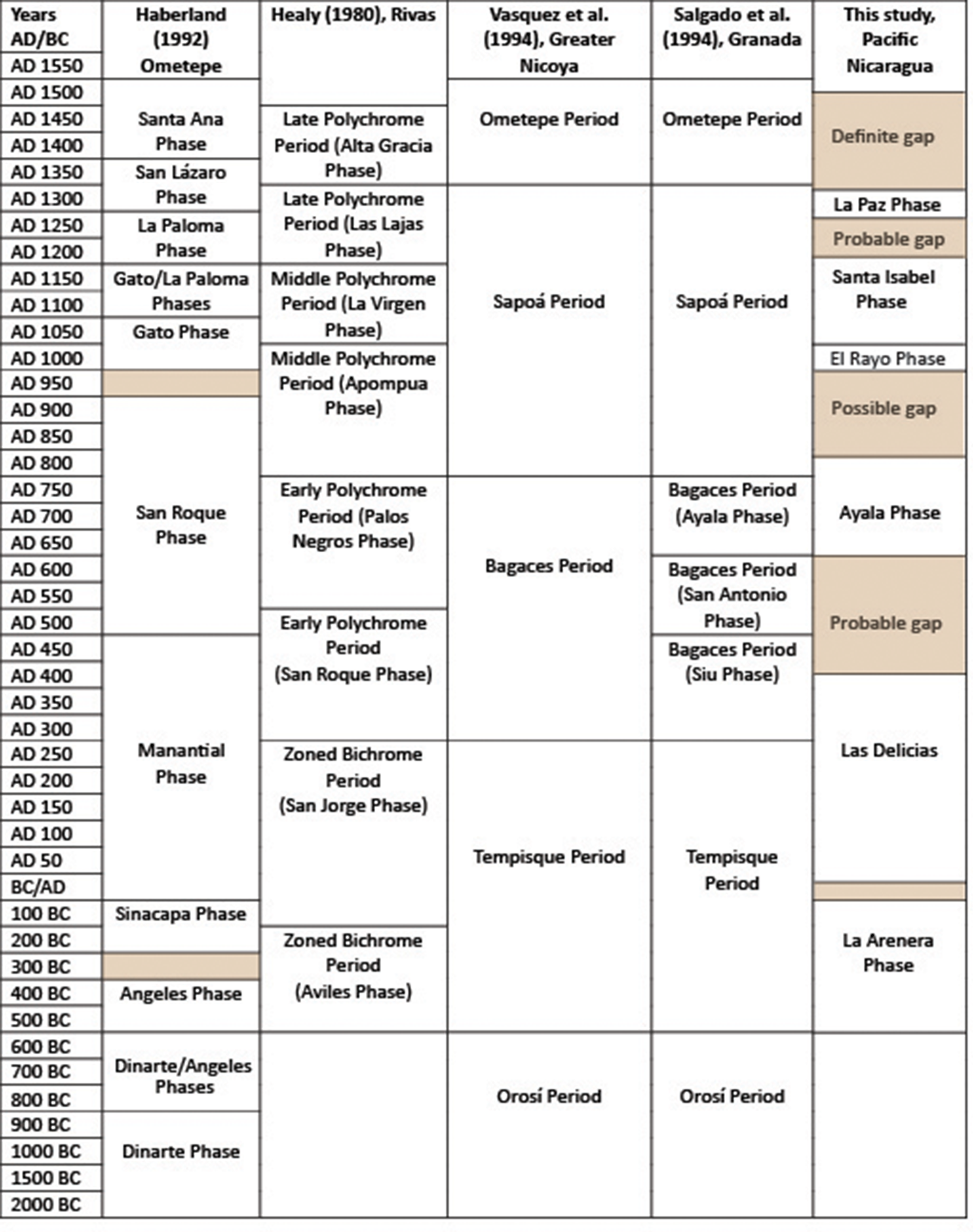
Figure 10 Long description
The timeline compares cultural phases across different studies for Pacific Nicaragua and Greater Nicoya from 2000 BC to AD 1550. The columns represent different studies: Haberland (1992) Ometepe, Healy (1980) Rivas, Vasquez et al. (1994) Greater Nicoya, Salgado et al. (1994) Granada and a study on Pacific Nicaragua. Each row corresponds to a time period, with specific phases or periods listed under each study. Notable phases include the Santa Ana Phase, La Paloma Phases and San Roque Phase. Gaps and probable gaps are indicated in the Pacific Nicaragua column, such as the La Paz Phase and El Rayo Phase. The timeline provides a comparative view of the cultural-historical chronology in the region, highlighting overlaps and gaps in the archaeological record.
Gantt chart showing predicted periods of a ceramic complex’s existence and popularity given the current data.
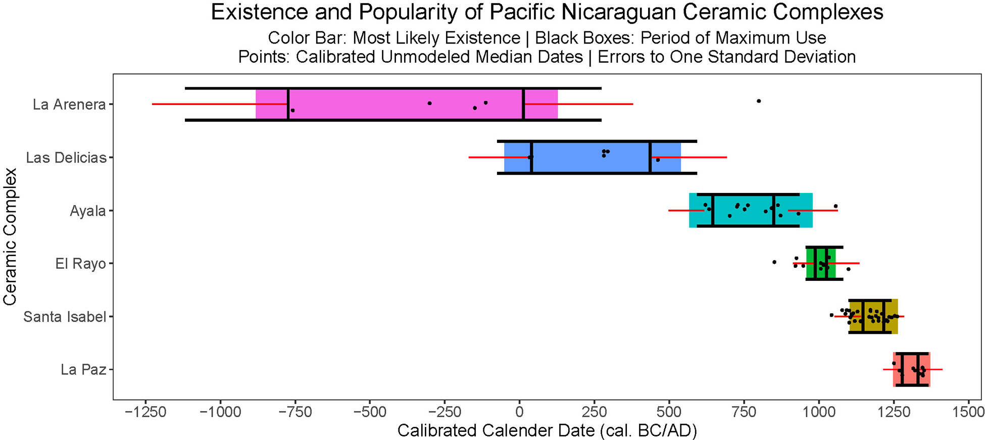
Figure 11 Long description
A chart titled 'Existence and Popularity of Pacific Nicaraguan Ceramic Complexes' displays data on the calibrated calendar date (calibrated BC/AD) on the x-axis and ceramic complex names on the y-axis. The complexes listed are La Arenera, Las Delicias, Ayala, El Rayo, Santa Isabel and La Paz. Color bars indicate the most likely existence period, black boxes show the period of maximum use and points represent calibrated unmodeled median dates with errors to one standard deviation. The timeline spans from approximately 1250 BC to 1500 AD.
Stacked area diagram showing the likelihood a given year falls within a particular phase.
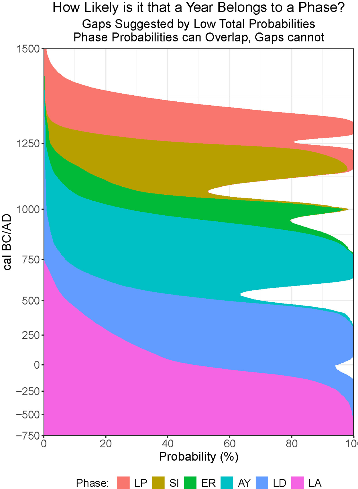
Figure 12 Long description
A stacked area diagram illustrates the likelihood of a year belonging to a specific phase. The x-axis represents probability in percentage, ranging from 0 to 100. The y-axis is labeled 'cal BC/AD' and spans from negative 750 to 1500. The diagram includes multiple overlapping colored areas, each representing different phases labeled as LP, SI, ER, AY, LD and LA. The title at the top reads 'How Likely is it that a Year Belongs to a Phase?' with a note that gaps are suggested by low total probabilities and that phase probabilities can overlap, but gaps cannot.
The naming convention employed for our new phases identifies chronological units best represented from the dated archaeological contexts. For example, the Ayala phase, for which seven dates were recovered from the Ayala type site, or the Santa Isabel phase, for which 12 dates were recovered from the Santa Isabel type site. Undoubtedly, future research programs will encounter other sites from which additional dates will be added to the corpus to fill in the gaps in the sequence, and perhaps better characterize the suggested phases. Additional refinements to the regional periodization may also be expected based on new data and/or based on implementation of different modeling assumptions. As demanded by good scientific practice, these time periods should be subject to critical evaluation as new information becomes available. Nevertheless, these represent the best contexts under the current state of the archaeological record.
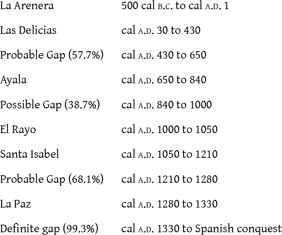
For purposes of discussion, but recognizing that choosing specific begin and end dates for our chronological units inadequately represents the results of our Bayesian modeling, we propose the following sequence of culture-historical phases for the last 2,000 years of Pacific Nicaragua prehistory based on the median values of the start and end dates of the period of maximum use rounded to the nearest decade. We assume a “transitionary” phase or coexistence between two adjacent complexes for dates outside of the periods unless otherwise indicated by gaps. Probable gaps are those periods of time where the model predicts there to be no existing complex with a greater than 50 percent probability, with possible gaps having greater than a 35 percent probability:
Generally, the data are consistent with a sequential model as proposed by cultural- historical similarity seriation. With only two exceptions, the periods of maximum use of neighboring phases are independent of each other in less than 6 percent of simulations (Figure 13). The earliest potential set of overlapping phases—a 47 percent likelihood for La Arenera-Las Delicias—may in large part be due to the limited amount of dating. However, other lowland Mesoamerican regions commonly show a coexistence between early phases in the archaeological record (Blake et al. Reference Blake, Clark, Voorhies, Michaels, Love, Pye, Demarest and Arroyo1995; Mejía Ramón Reference Mejía Ramón2023). The latter set of overlapping phases is a near one-in-four chance that El Rayo and Santa Isabel overlap. Despite the sizable number of dates for both phases, El Rayo’s short existence—combined with a minor plateau in the calibration curve—makes it difficult to resolve the former’s end and Santa Isabel’s beginning.
Difference between the end of a particular period and the start of the next, indicating gaps and overlaps in periods of popularity.
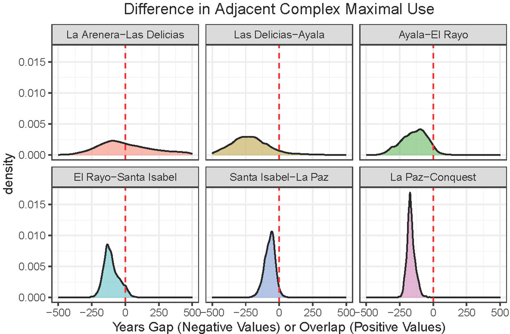
Figure 13 Long description
The image contains six density plots titled 'Difference in Adjacent Complex Maximal Use'. Each plot represents different periods with the x-axis labeled 'Years Gap (Negative Values) or Overlap (Positive Values)' and the y-axis labeled 'density'. The plots are arranged in two rows. The first row includes: 1) La Arenera–Las Delicias, showing a distribution with a peak around zero; 2) Las Delicias–Ayala, displaying a spread with a peak slightly to the left of zero; 3) Ayala–El Rayo, with a peak near zero. The second row includes: 4) El Rayo–Santa Isabel, showing a sharp peak at negative values; 5) Santa Isabel–La Paz, with a peak at negative values; 6) La Paz–Conquest, displaying a peak near zero. Each plot features a red dashed vertical line at zero, indicating the transition point between gap and overlap periods.
While the periods of maximum use for the most part are independent, the same cannot be said of the period of existence (Figure 14). Only Ayala is more likely than not to be independent of its neighbors, and this only by a margin of 8 and 5 percent, respectively. Overlaps between adjacent phases are often substantial enough such that considering them “transitional” grossly understates their duration. On average, other ceramic types were in use for between one-fifth (La Paz) to nearly all (El Rayo) of the complex’s existence. Thus, while ceramic remains from short-lived complexes may be suggestive of coevality between sites (akin to Rowe’s [Reference Rowe1962] phases), ceramics in Pacific Nicaragua are poor indicators of sequentiality (more akin to Rowe’s stages).
Difference between the disappearance of a particular ceramic complex and the appearance of the next, indicating gaps and overlaps in material existence.
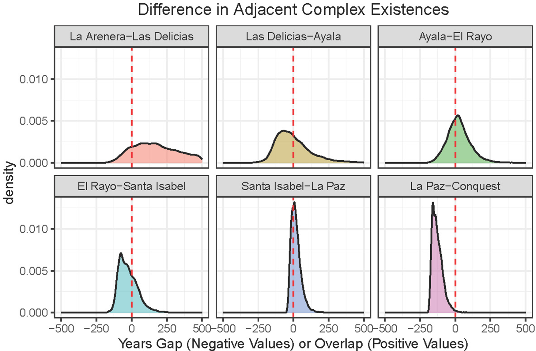
Figure 14 Long description
Six density plots illustrate the differences in adjacent complex existences, indicating gaps or overlaps in years. Each plot is labeled with a specific comparison: La Arenera to Las Delicias, Las Delicias to Ayala, Ayala to El Rayo, El Rayo to Santa Isabel, Santa Isabel to La Paz and La Paz to Conquest. The x-axis is labeled 'Years Gap (Negative Values) or Overlap (Positive Values)' and the y-axis is labeled 'density'. Each plot features a curve with a peak and a red dashed line at zero, indicating the point of transition between gap and overlap. The density curves vary in shape and spread, reflecting the differences in the periods of existence for each complex pair.
Discussion
Based on a large amount of recent archaeological research, the cultural development of Pacific Nicaragua is coming into focus. One point of confusion, however, is that by sharing the existing chronological sequence with other parts of Nicaragua and Costa Rica, particular qualities become blurred. For example, the diagnostic ceramics of Pacific Nicaragua are not the same as those from the eastern side of Lake Cocibolca (Donner and Geurds Reference Donner and Geurds2018), or across the political border in Costa Rica (Vázquez et al. Reference Vázquez Leiva, Lange, Hoopes, Zamora, González, Quirós, Bishop, Borgnino, Umaña, Ulloa, Pérez, Fletcher, Miranda, Lauthelin, Rigat, González and Galeano1994). For this reason, we believe that it is important to define a new, more localized chronology for the region lying south and west of Lake Xolotlan and Lake Cocibolca.
The early occupations of the Nicaragua lakes basin remain poorly defined. A Lowe point allegedly found on Ometepe Island (Prufer et al. Reference Prufer, Robinson and Kennett2021) hints at late Paleoindians around Lake Cocibolca with the capability of crossing from the mainland to Ometepe Island. Footprints at Acahualinca, within metropolitan Managua, have recently been verified to pertain to an Archaic Period group impacted by a volcanic eruption between about 7000 and 7500 cal BP (Neff Reference Neff2023; see Schmincke et al. Reference Schmincke, Kutterolf, Perez, Rausch, Freundt and Strauch2009 and Bryan Reference Bryan1973 for earlier dating efforts). Haberland’s (Reference Haberland1986, Reference Haberland, Lange, Sheets, Martinez and Abel-Vidor1992) discovery of “Dinarte Phase” pottery showing similarities to the Tronadora Complex of Costa Rica (Hoopes Reference Hoopes1994) in deep excavations at Los Ángeles, Ometepe Island hints at early farming populations in the lakes basin. Although recent efforts to resample the Dinarte Phase (Neff and Brown Reference Neff and Brown2022) returned only equivocal results, a radiocarbon date associated with Los Ángeles Phase pottery types (Haberland Reference Haberland, Lange, Sheets, Martinez and Abel-Vidor1992; Healy Reference Healy1980) from Los Ángeles (PSU 9952) appears to show people on the island prior to 500 cal b.c. Unfortunately, despite a small standard deviation on this date, the “Hallstatt Plateau” on the radiocarbon curve spreads the two-sigma calibrated range across two-and-a-half centuries, from 800 cal b.c. to 565 cal b.c. (supplementary material:Table S1). Pottery associated with the date includes types we place in the La Arenera phase (discussed later), which is where we place it in our model. Analysis of sediment cores designed to detect early human impacts around Lakes Cocibolca and Xolotlan are currently underway and will be presented in future publications.
The La Arenera complex (in existence from before 500 cal b.c.–cal a.d. 120) is best known from the Managua area, including two 14C dates from the type site. Diagnostic ceramics include Rosales Black-on-Red Incised serving vessels and figurines, Bocana Incised Toya variety, and Negative Resist vessels (Figure 15) similar to Usulután Negative Resist from El Salvador. Similar ceramic assemblages were found by Lange and his colleagues during salvage excavations in Managua (Brown et al. Reference Brown, Krieg, Wilmott and Lange1996; Espinoza Perez Reference Espinoza Perez and Lange1995). As modeled here, the period of maximum use (hereafter, simply “phase”) extends from 500 cal b.c. or earlier through around 100 cal b.c.
Diagnostic ceramics from the La Arenera phase. (a) Rosales Black-on-Red Incised, (b) Bocana Incised, Toya variety, (c) Usulutan-like Negative Resist.
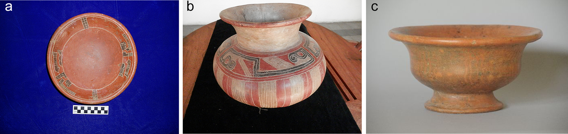
Figure 15 Long description
The image A shows a round ceramic plate with incised patterns along the rim, placed on a surface with a scale for size reference. The image B shows a ceramic pot with a wide body and narrow neck, featuring intricate geometric designs. The image C shows a ceramic bowl with a flared rim and a simple, smooth surface.
The end of occupation at the type site of La Arenera certainly came suddenly, with the explosive eruption of Asososca Maar and the resulting burial of the occupation surface with more than eight meters of sand (Pardo et al. Reference Pardo, Macías, Giordano, Cianfarra, Scolamacchia and Bellatreccia2009), an event now dated to between 345 and 45 cal b.c. (Avellán et al. Reference Avellán, Macias, Pardo, Scolamacchia and Rodriguez2012; this is sample A14759).
The transition between the La Arenera and Las Delicias phases is still very poorly defined. Given the present information, there is nearly a 50/50 chance of there being an overlap or a gap ranging up to hundreds of years between the periods of maximum use. This largely arises from the small number of dates from both phases. Such a gap, if confirmed by future work, may have arisen from intense volcanism, possibly starting with the Asososca Maar eruption that covered La Arenera itself. Although one volcanological study (Perez and Freundt Reference Perez and Freundt2006; Schmincke et al. Reference Schmincke, Kutterolf, Perez, Rausch, Freundt and Strauch2009) suggests that a highly explosive eruption of Masaya volcano deposited the Masaya Triple Layer tuff on the Managua zone shortly after the Asososca eruption, recent re-dating of the Acahualinca footprints (Neff Reference Neff2023) places this event closer to 7,000 years ago, as proposed by Avellán et al. (Reference Avellán, Macias, Pardo, Scolamacchia and Rodriguez2012).
The Las Delicias complex (in existence ca. 50 cal b.c.–cal a.d. 530) is defined based on two 14C dates from the Las Delicias cemetery in Managua on the shore of Lake Xolotlan together with three dates from San Cristobal, also close to the shore of Lake Xolotlan (Espinoza Perez et al. Reference Espinoza Perez, Obando, Garcia and Caceres2023). The model indicates a most likely phase duration of roughly 400 years, but with the 90 percent highest probability density range extending up to 700 years. Much of this uncertainty is due to the limited number of dates.
Diagnostic ceramics include Negative Resist vessels, including spouted vessels, and Bocana Incised vessels (Figures 16a–b). Both the Las Delicias and San Cristobal cemeteries included these vessels as grave goods, in addition to occasional ground stone artifacts.
Diagonstic ceramics from the Las Delicias phase. (a) Bocana Incised, (b) Negative Resist spouted vessel, (c) Espinoza Red Banded, (d) Jobo Punctate, and (e) Sonzapote Orange.
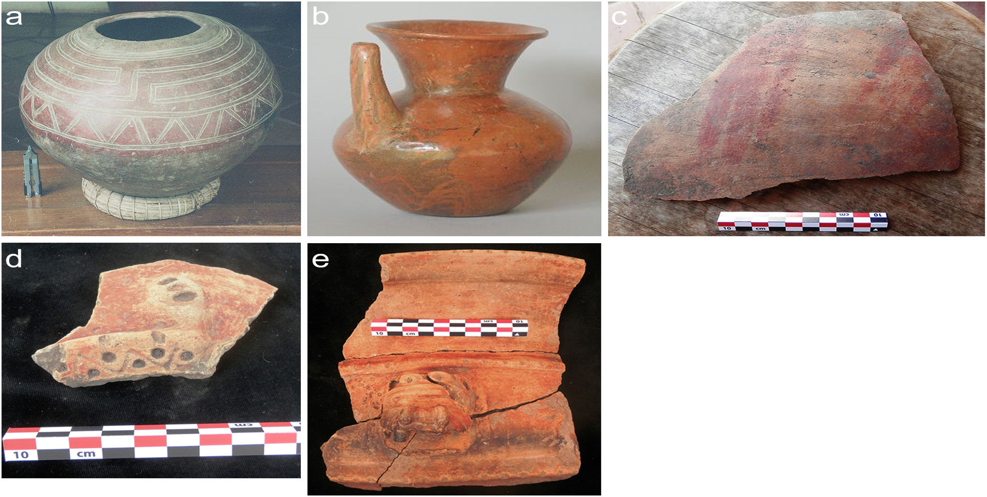
Figure 16 Long description
The image A shows a Negative Resist spouted vessel with intricate patterns. The image B shows a Bocana Incised vessel with a spout and handle. The image C shows a fragment of Espinoza Red Banded ceramic with a scale for size reference. The image D shows a fragment with circular patterns and a scale. The image E shows a Sonzapote Orange ceramic fragment with a decorative element and a scale for size reference.
Ticuantepe, a unique burial complex was discovered during deep construction work. Two adult individuals had been placed on aligned grinding stones and were accompanied by two large vessels filled with additional human skeletal remains, as well as several small redware ollas. The chronological assignment of this context was provided by Jorge Zambrana Fernández (personal communication 2016) based on comparative materials.
The early context at Sonzapote may also date to the Las Delicias phase, based again on Zambrana’s identification of Jobo Incised and Espinoza Red Banded pottery (Figures 16 c–d; McCafferty et al. Reference McCafferty, Pavón Sanchez and Galeano Rueda2013). The predominant ceramic type, however, has an orange surface with modelled and incised decoration that we call Sonzapote Orange (Figure 16e).
A probable gap (present in 57.7 percent of simulations) of up to 460 years separates Las Delicias from the subsequent Ayala phase.
The Mombacho volcano south of Granada experienced a catastrophic flank collapse with a minimum age of a.d. 345 (Shea et al. Reference Shea, van Wyk de Vries and Pilato2008; Stansell Reference Stansell2013), when millions of tons of basalt boulders slid into Lake Cocibolca to form the Asese peninsula and several hundred surrounding islands. The resultant tsunami waves may have washed away coastal villages, while sulfur dioxide and other toxic compounds could have polluted the water, impacting the natural environment. The southern side of the volcano then also collapsed between a.d. 270 and a.d. 650. Both catastrophic events may help explain the relative lack of dated sites between about a.d. 300–600, at least around Granada.
The Ayala complex (cal a.d. 570–970) is well defined from the type site of Ayala, as well as nearby El Rayo. Three dates from Operation 7 at Ayala and four dates from Operation 13 are in stratigraphic sequences and are modeled as such. However, Beta-77223 from the Operation 7 sequence, had an extremely low agreement index and including it in the model reduced the model agreement index to below the 60 percent acceptability cutoff, motivating us to flag it as an outlier. The model suggests a duration of about 200 years for the phase, beginning around cal a.d. 650 and ending within a few years of cal a.d. 840.
Compositional analysis of redware pottery from this time period indicates that Ayala was a major manufacturing center, distributing its ceramics throughout the region (Dennett Reference Dennett2016; Dennett et al. Reference Dennett, Salgado and Bishop2019). Diagnostic ceramics include Tola Trichrome, Leon Punctate, Chavez White-on-Red, and Charco Black-on-Red (Figures 17a–c). Two new types introduced during this period are Momta Polychrome (Figure 17d) and Belo Polychrome, manufactured locally but with stylistic elements related to a wider “constellation of practice” (Dennett Reference Dennett2016, Reference Dennett, Steinbrenner, Geurds, McCafferty and Salgado2021; Dennett et al. Reference Dennett, Salgado and Bishop2019).
Diagnostic ceramics from the Ayala phase. (a) Chavez White on Red. (b) Leon Punctate. (c) Tola Trichrome, (d) Momta Polychrome.
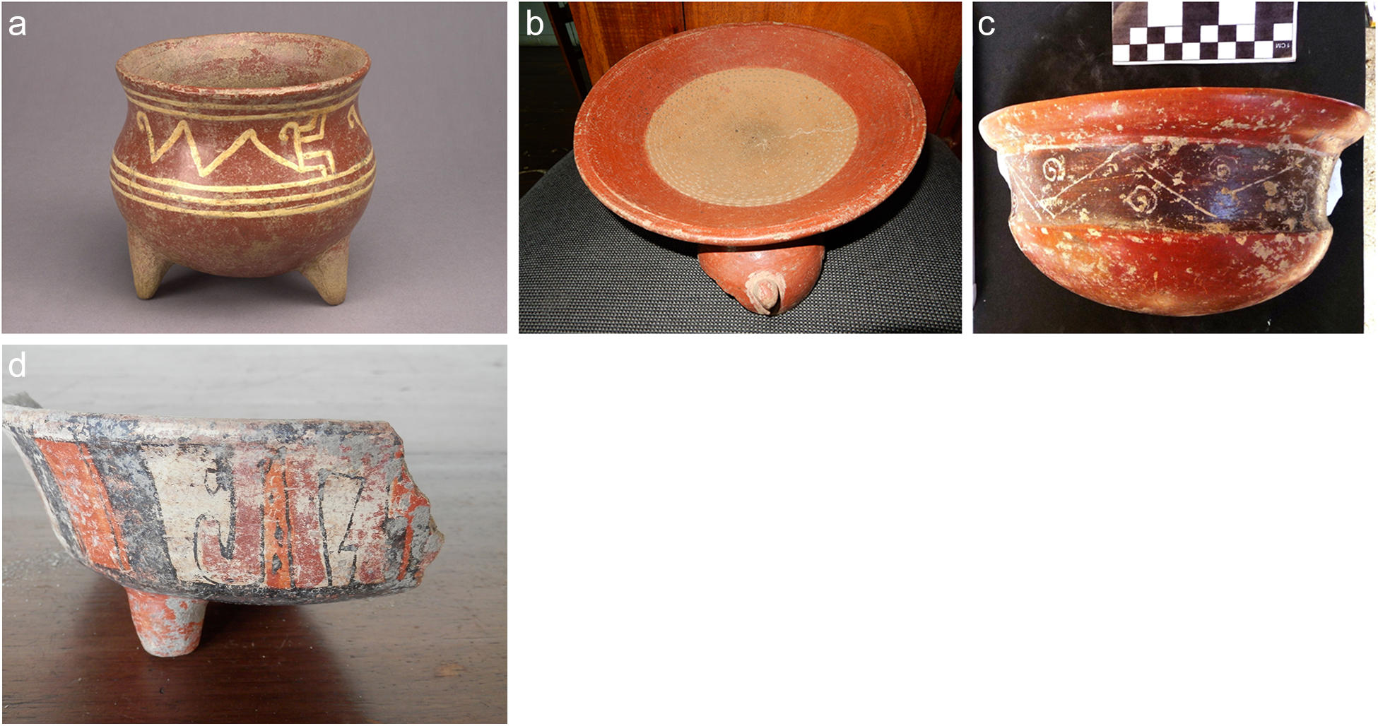
Figure 17 Long description
The image shows four ceramic artifacts labeled a to d. The artifact labeled a is a pot with three legs and decorative patterns around its body. The artifact labeled b is a shallow bowl with a wide rim and a single leg. The artifact labeled c is a bowl with a rounded body and intricate patterns on its surface. The artifact labeled d is a fragment of a ceramic piece with visible designs and a single leg. Each artifact has unique shapes and decorative elements.
The El Rayo complex (cal a.d. 960–1050) follows another possible gap of up to 300 years—present in 38.7 percent of simulations after the end of the Ayala phase. While four of the 11 dates have median calibrated unmodeled dates before the modeled start of the complex’s existence, a plateau on the calibration curve between a.d. 910–980 means that any ante quem constraints on these dates will tend to push their modeled ages rapidly toward recency—especially given that there is at present about a one-in-three chance that Ayala did not exist during the plateau. However, in light of the dramatic break from the previous ceramic complex, we are inclined to interpret this possible gap between Ayala and El Rayo as valid and indicating discontinuity between the two phases. As indicated by the stratigraphic sequence from El Rayo’s Locus 2 and the associated 14C dates the transition seems to have been rapid (see Figure 5), although the continued use of Ayala phase redwares implies a degree of cultural integration.
Redware ceramics are replaced with polychromes, especially varieties of Papagayo Polychrome (Figures 18a–d). This change includes new vessel forms and decorative elements. These may be developments from the Momta/Belo Polychromes of the Ayala phase, but also relate to Las Vegas Polychrome from Honduras. Although compositional analysis by Dennett (Reference Dennett2016, Reference Dennett, Steinbrenner, Geurds, McCafferty and Salgado2021) indicates that Granada continued as a major ceramic manufacturing area, she also finds that compositional diversity increased, indicating proliferation of workshops. Another innovation during the El Rayo phase was large, oval vessels known as Sacasa Striated, which were used both for cooking (probably preparation of a beverage similar to pinolillo) but subsequently for urn burials (Figure 18e; McCafferty and McCafferty Reference McCafferty and McCafferty2012). Other decorated pottery types introduced during this phase include Vallejo Polychrome, Castillo Engraved, and Lago Modelled (Figures 18f–h). Other evidence for discontinuity in the early ninth century includes introduction of a new fishing toolkit (Wilke Reference Wilke, Steinbrenner, Geurds, McCafferty and Salgado2021) and changes in mortuary practices (McCafferty et al. Reference McCafferty, Waters-Rist, McCafferty, Fricker, Manion, Steinbrenner, Geurds, McCafferty and Salgado2021). While hesitant to attribute material culture change to immigration, we would be remiss not to acknowledge that the early ninth century also stands out as the time period when the Chorotega, immigrants from Central Mexico, are thought to have arrived in Pacific Nicaragua (Steinbrenner Reference Steinbrenner, Steinbrenner, Geurds, McCafferty and Salgado2021a).
Diagnostic ceramics for the El Rayo phase. (a–d) Papagayo Polychrome, (e) Sacasa Striated, (f) Vallejo Polychrome, (g) Castillo Engraved, (h) Lago Modelled.
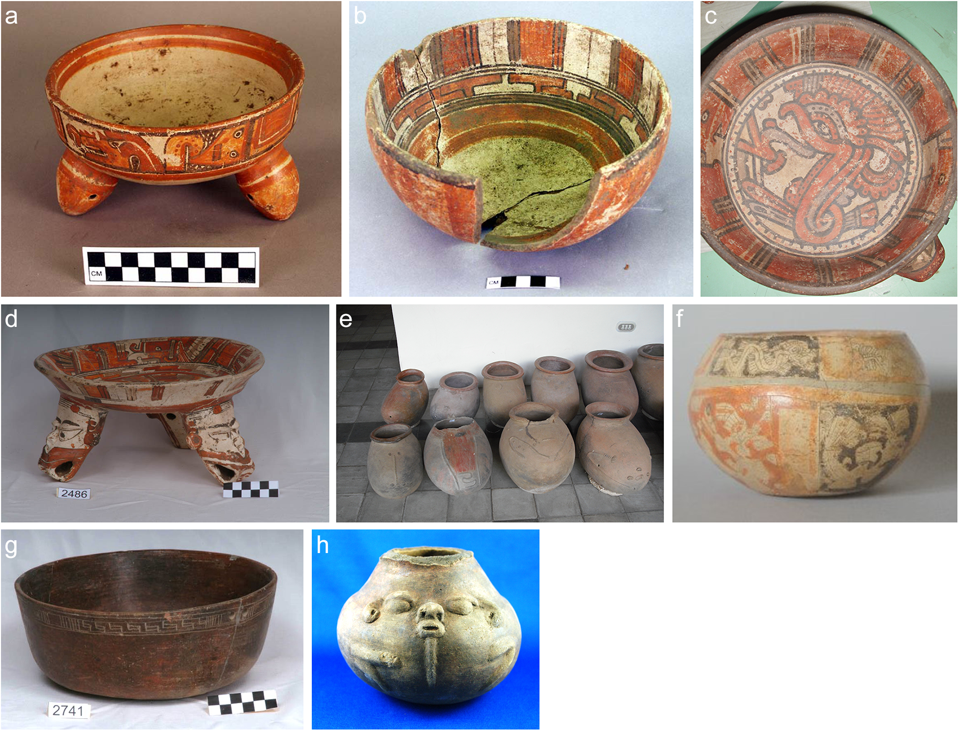
Figure 18 Long description
The image shows eight ceramic vessels labeled a to h. Image a shows a Papagayo Polychrome bowl with three legs. Image b shows a Papagayo Polychrome bowl with a cracked side. Image c shows a top view of a Papagayo Polychrome bowl with intricate designs. Image d shows another Papagayo Polychrome bowl with a wide base. Image e shows several Sacasa Striated vessels lined up. Image f shows a Vallejo Polychrome bowl with decorative patterns. Image g shows a Castillo Engraved bowl with geometric designs. Image h shows a Lago Modelled vessel with a face-like design on the front.
The Santa Isabel complex (in existence cal a.d. 1110–1260) is best defined at the type site of Santa Isabel, but is also found at El Rayo, La Paz, Nejapa, Sonzapote, and Tepetate. Ceramic types that originated during the preceding period, especially polychromes, continue into Santa Isabel times, leading us to favor continuity in occupation, despite the probable century-long gap between the El Rayo and Santa Isabel phases according to the model. In addition to Papagayo and Vallejo Polychromes, Bramadero, Madeira, and Pataky Polychromes were added to the assemblage of serving wares (Figures 19a–c). Based on the number of sites with Santa Isabel phase dates this may have represented a period of population growth and diversification. Santa Isabel itself was by far the largest site west of Lake Colcibolca at this time (Niemel Garrard Reference Niemel Garrard, Steinbrenner, Geurds, McCafferty and Salgado2021). It may have been a “port of trade” for the region (Chapman Reference Chapman, Polanyi, Arensberg and Pearson1957) and was the site of manufacture of exotic goods such as greenstone, shell, textiles, and carved bone jewelry (McCafferty Reference McCafferty2008, Reference McCafferty, Steinbrenner, Geurds, McCafferty and Salgado2021; McCafferty and McCafferty Reference McCafferty and McCafferty2008). We cannot, however, discard the possibility that bias in archaeological attention has produced a sample in which Santa Isabel contexts are overrepresented.
Diagnostic ceramics from the Santa Isabel phase. (a) Bramadero Polychrome. (b) Madeira Polychrome. (c) Pataky Polychrome.
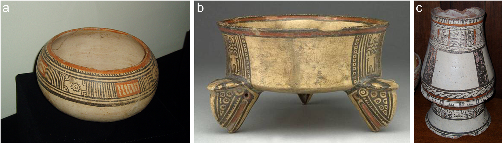
Figure 19 Long description
The image A shows a round ceramic bowl with intricate geometric patterns around its upper section. The image B shows a tripod vessel with three decorated legs and a wide, shallow bowl on top, featuring similar geometric designs. The image C shows a double-chambered vase with two stacked sections, each adorned with detailed patterns and motifs.
The La Paz phase (cal a.d. 1280–1330) closely follows Santa Isabel, with only 3 percent of simulations suggesting any gap whatsoever between the periods of maximum use. Indeed, 66.1 percent of simulations suggest an overlap of up to 20 percent between the two complexes’ existence. La Paz is best represented by sites along the shore of Lake Xolotlan.
The major Santa Isabel phase sites of El Rayo and Santa Isabel seem to have been abandoned around the beginning of the La Paz period, which conceivably could be evidence of the ethnic changes and implied warfare mentioned in ethnohistorical texts (Ibarra Rojas 2010). Diagnostic ceramics of this phase include continuations of types from Santa Isabel, with the addition of Luna and Managua Polychromes (Figures 20a–b), but we have not carried out detailed ceramic analysis to evaluate the case for continuity.
Diagnostic ceramics from the La Paz phase. (a) Luna Polychrome. (b) Managua Polychrome.
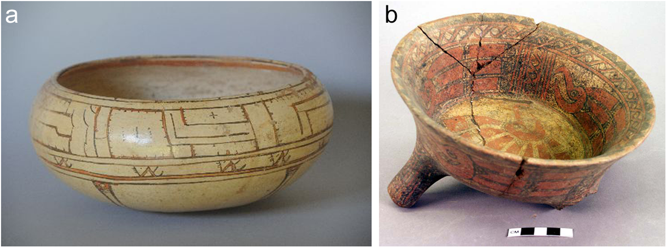
Figure 20 Long description
The image A shows a ceramic bowl with geometric patterns around its exterior. The bowl has a smooth, rounded shape with a slightly inward-curving rim. The image B shows a ceramic bowl with a tripod base. The interior features a complex pattern and the bowl appears to have been repaired, as indicated by visible cracks. A scale is present beneath the bowl in image B.
La Paz is the end of the Prehispanic sequence in our model. The 90 percent probability range for its termination extends from cal a.d. 1321 through 1427, and even the end of the decline period specified by our trapezoidal model only extends to cal a.d. 1506. Thus, the available database includes no evidence of occupation at the time of the Spanish invasion nor likely for a period of up to 200 years prior to it, despite ethnohistoric accounts to the contrary (Ibarra Rojas Reference Ibarra Rojas2001; McCafferty Reference McCafferty, Anderson, Clark and Anderson2015; Steinbrenner and McCafferty Reference Steinbrenner, McCafferty, Steinbrenner, Geurds, McCafferty and Salgado2021). This contradiction may result from modern population growth over locations of final Prehispanic occupation, which as a result have not been investigated. Salvage archaeology projects in urban areas, such as Managua, Granada, and Rivas might rectify this bias in the future, although no such evidence has been recovered thus far, nor have late period artifacts been identified in visual inspections of construction trenches.
Conclusions
This proposed chronology differs from the existing sequence both in terminology and divisions, and for its specific focus on sites, dates, and diagnostic ceramics from Pacific Nicaragua. When the Greater Nicoya chronology was proposed in the early 1990s, relatively little was known about Nicaragua, and little work was being done there. Consequently, the Greater Nicoya sequence was heavily biased in favor of Costa Rican sites and ceramic types. Nicaragua was included based on Norweb’s (Reference Norweb1964) definition of Greater Nicoya that included Pacific Nicaragua and a handful of small projects, but the reality was that it contributed little to the interpretations.
In contrast, however, 30 years later we have information from several major projects and a substantial number of radiocarbon dates. This permits a critical evaluation of how well different regions within Greater Nicoya align chronologically. At least for the later periods there are significant differences between decorated ceramics and mortuary practices between Nicaragua and Costa Rica, raising the possibility that Greater Nicoya may have been less uniform in material culture than is often assumed and therefore invites questions as to the validity of the concept (Ibarra Rojas Reference Ibarra Rojas, Steinbrenner, Geurds, McCafferty and Salgado2021). The goal of this revision to the Pacific Nicaragua chronology, then, is to create a sequence that is more internally consistent. It should still be comparable with that of northwestern Costa Rica, but the distinct, local manifestations of the shared tradition deserve recognition.
The new chronology employs terminology based on “type sites” where the phases are well-represented based on absolute dating, and ideally with well-developed ceramic analysis to document the diagnostic ceramic types. In contrast to the traditional Greater Nicoya sequence with five periods, the proposed chronology is divided into six phases of shorter duration, but with several gaps for which we currently lack dated sites. Some of the gaps in our Pacific Nicaragua chronology may indicate periods of demographic contraction caused in part by regionally significant volcanic disasters. For Greater Nicoya as a whole, we believe our results from Pacific Nicaragua imply that much finer chronological distinctions are possible, as indicated by the last column of Figure 10.
As with all archaeological analysis, the caveat is that with more data further refinements and revisions will need to be made. After several decades of intense research, this is a good time to consider recent work and develop new hypotheses. This proposed chronology is just such a new suggestion, open for critical review and hopefully further refinement as new data are generated.
On a larger scale, “Greater Nicoya” has often been considered as a southern frontier of ancient Mesoamerica (McCafferty et al. Reference McCafferty, Amador, González, Dennett, Nichols and Pool2012). This new chronology and cultural sequence for Pacific Nicaragua offers the potential to better distinguish the frontier, particularly via the dramatic changes in material culture across the Ayala/El Rayo transition. The innovative Papagayo Polychrome type with its cream-colored slip and multiple varieties bears similarities with Las Vegas Polychrome from Honduras, but also with polychromes from the Gulf Coast and the central highlands of Mexico (McCafferty and Dennett Reference McCafferty, Dennett and Lacayo2017). Vallejo Polychrome often features iconography closely related to the Mixteca-Puebla stylistic tradition, including variations on the feathered serpent and calendrical glyphs (Manion and McCafferty Reference Manion, McCafferty and Lacayo2017; McCafferty Reference McCafferty2019; McCafferty and Steinbrenner Reference McCafferty, Steinbrenner, Waters-Rist, Cluny, McNamee and Steinbrenner2005a). The greater variety of polychrome types in the subsequent Santa Isabel period, however, diverges from central Mexican themes, suggesting local development. The mechanisms of contact and interaction remain problematic, but the fact that Mesoamerican languages were still spoken in Pacific Nicaragua in the Colonial period (and into the early twentieth century) suggests the possibility of continuous interaction (Constenla Reference Constenla1994). And yet other cultural characteristics, such as foodways, are not consistent with Mesoamerican culture (McCafferty Reference McCafferty, Anderson, Clark and Anderson2015).
This reconsideration of Pacific Nicaragua’s chronology and cultural sequence will hopefully lead to further research and improved interpretations of the enigmatic region with apparent relevance to ancient Mesoamerica. Importantly, this new chronological “backbone” will enable more nuanced interpretations of the sociocultural phenomena involved in Pacific Nicaragua and regional interactions. For example, what was the significance of the Negative Resist ceramics of the La Arenera and Las Delicias phases in relation to El Salvadoran and Honduran populations (for example, were Usulután ceramics imported to Nicaragua from western El Salvador)? To what extent were the inhabitants of Pacific Nicaragua interacting with Chibchan groups from eastern Nicaragua and Costa Rica? In what ways were Mesoamerican migrants impacting autochthonous societies beginning in the late Ayala and El Rayo phases? Did that contact continue in the Santa Isabel phase? And an overarching question remains of what happened in the final centuries prior to European contact, for which we currently lack significant dated contexts? From a larger theoretical perspective, what can Pacific Nicaragua contribute to issues of frontier dynamics, as a periphery to the Mesoamerican core that may have played an important role in provisioning exotic materials (such as cacao) via an extensive trade network (Steinbrenner Reference Steinbrenner and McNeil2006)? We hope that this new chronological structure will encourage more rigorous and imaginative interpretations that will ultimately integrate Pacific Nicaragua into discussions of greater Mesoamerican cultural dynamics.
Supplementary material
The supplementary material for this article can be found at https://doi.org/10.1017/S0956536126100935.
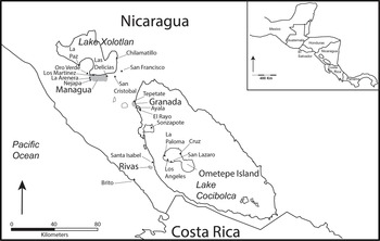
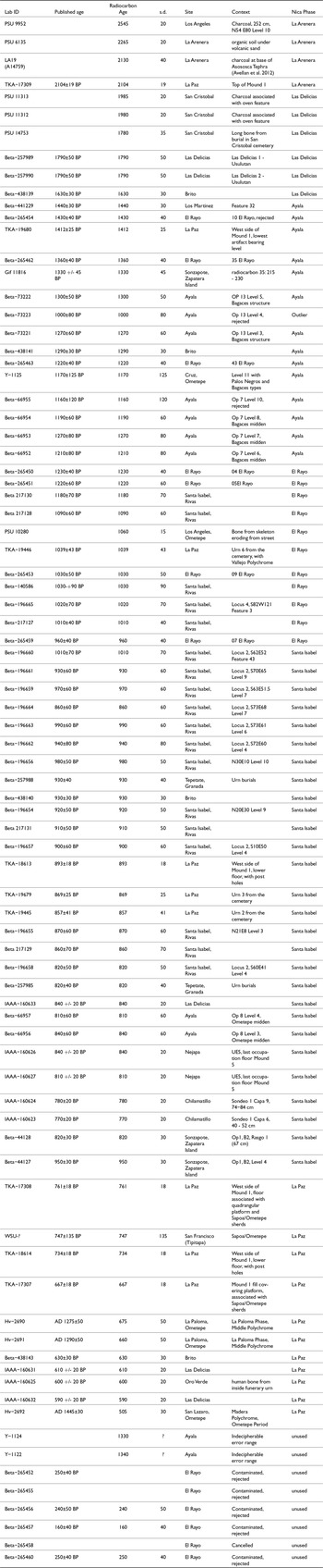
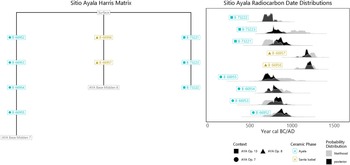
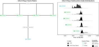
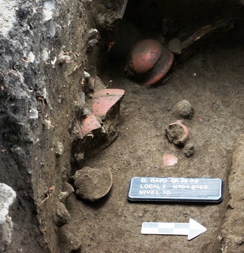
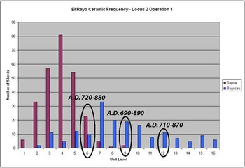


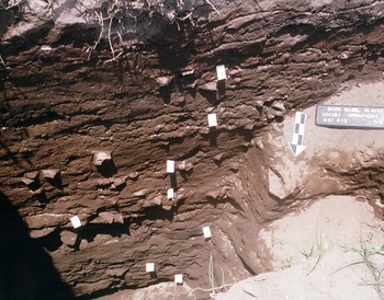
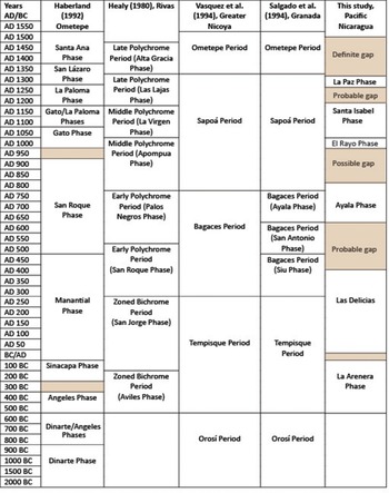
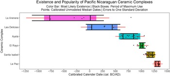

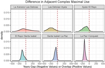


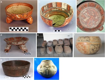

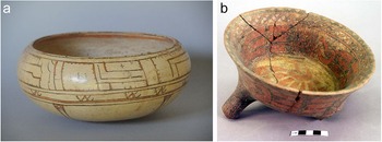


 Open access

