




Introduction
The use of the calendar system, which interlocked the Long Count, the 260-day divinatory calendar, and the 365-day solar calendar, was a hallmark of lowland Maya kingship during the Classic period (a.d. 250–900). This system incorporates royal events into a chronological sequence, thereby making the royal house distinct from other social members. The events include not only rulers’ biographical stages such as birth, accession, marriage, and death, but also warfare and periodic rituals at the end of k’atun (20 years) and tun (10 years) periods. Among period-ending rituals are chok ch’aaj, “scattering drops or incense;” il, “witness or supervise;” k’altuun, “stone binding” (for El Palmar examples, see Esparza Olguín and Tsukamoto [Reference Esparza Olguín, Tsukamoto, de Velasco and Vega2011]; Tsukamoto and Esparza Olguín [Reference Tsukamoto and Olguín2025]). Recent research conducted at the site of San Bartolo, Guatemala, indicates that the 260-day divinatory calendar was used together with the title of ajaw (“lord,” “noble,” or “ruler”) as early as 300–200 b.c. (Saturno et al. Reference Saturno, Beltrán, Rossi, Friedel, Chase, Dowd and Murdock2020; Stuart et al. Reference Stuart, Hurst, Beltrán and Saturno2022). In contrast, it remains challenging to find tangible evidence that the lowland Maya employed the Long Count prior to the Classic period (Stuart Reference Stuart2011). The earliest securely identified Long Count in the central Maya Lowlands is carved on Tikal Stela 29, which dates back to 8.12.14.8.15. 13 Men 3 Sip or July 9, a.d. 292 in the Gregorian calendar based on the 584286 correlation (Martin and Skidmore Reference Martin and Skidmore2012; Shook Reference Shook1960). While Popol Altar 1, Guatemala, appears to contain an earlier Long Count with a possible 7 bak’tun cycle, it is difficult to date accurately due to heavy erosion and incompleteness (Pahl Reference Pahl and Cordy-Collins1982). Furthermore, none of these Long Counts is articulated with royal events.
Our research at the archaeological site of El Palmar, located in southeastern Campeche, Mexico, provides clues to the relationship between the Long Count and emergent kingship in the central Maya Lowlands. We analyzed hieroglyphic inscriptions and iconographic images carved on three El Palmar monuments, Stelae 20, 45, and 46. Karl Herbert Mayer (Reference Mayer1991:12–13, Plates 33–38) previously documented the latter two stelae, especially identifying 8 bak’tun on Stela 46, although the 8 bak’tun glyph is truncated in his photograph. He pointed out the importance of these early stelae since all the El Palmar monuments previously reported by Sir Eric Thompson (Reference Thompson1936a) dates to the Late Classic period (a.d. 711–884). Despite Mayer’s efforts, no systematic study of El Palmar Stelae 45 and 46 has been conducted, likely due to their severe erosion. Many carved monuments at sites in southeastern Campeche are badly weathered because local limestone is soft and friable. Furthermore, there is a lack of information regarding the original locations and contexts of Stelae 45 and 46, which renders them even more challenging to study.
Technological innovations in the study of Maya hieroglyphs and iconographic images enable us to challenge this difficulty. Traditionally, scholars took photographs of monuments under daylight and raking light at night in the field. Illuminating a monument with artificial light from various angles was the standard method, which enhanced the visibility of glyphs and iconographic images (Graham Reference Graham1975:12). However, the quality of photographs depends largely on photographers’ skill, and uneven illumination under harsh environmental conditions sometimes obscures details in both under- and over-illuminated texts and images. Because many sites are located in remote areas, retaking photographs was not easy once fieldwork was completed. More recently, scholars employ photogrammetry, which has facilitated the capture of photographs during daylight hours and the subsequent creation of three-dimensional models in the field camphouse. While we can adjust the angle of illumination in software, the effectiveness of this technique still depends on external lighting conditions, which often fluctuate and affect the visibility of inscriptions and iconographic images shown in a single 3D model.
We addressed this issue by combining photogrammetry with a high-resolution 3D scanner, a method that further enhances the readability of heavily eroded inscriptions and early calendrical dates, especially on El Palmar Stela 46, which were previously illegible. The 3D scanner has its own lighting system, ensuring the monument is equally illuminated (Prager et al. Reference Prager, Gronemeyer and Wagner2020; Tokovinine Reference Tokovinine and Beliaev2013; Tokovinine and Fash Reference Tokovinine and Fash2008). Furthermore, with the help of local workers and a senior resident from Kiché Las Pailas, a modern community located at El Palmar, we attempted to recover the original locations of Stelae 45 and 46, although their precise placements require further investigation. The discovery of previously unknown inscriptions carved on Stela 20 helped us reconstruct the royal succession of the El Palmar kingdom associated with Stela 46. Our excavations at their locations contextualized inscriptions and iconographic images with archaeological data, allowing us to examine the relationship between the Maya calendars and the emergence of El Palmar kingship. Based on the results of El Palmar research we will discuss the emergence of kingship in the central Maya Lowlands.
Previous research on El Palmar’s early monuments
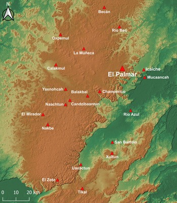
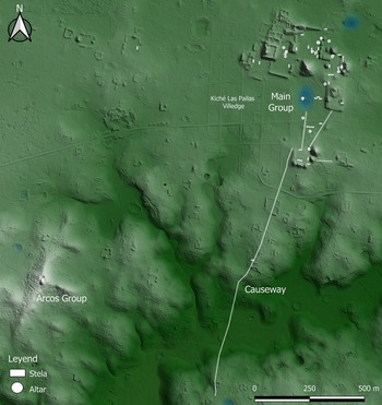
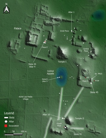
El Palmar was founded on the eastern edge of the central karstic upland, where several large Preclassic sites flourished, including El Mirador, Nakbe, Becan, Yaxnohcah, and Calakmul (Figure 1).The archaeological site of Mucaancah, located about 18 kilometers southeast of El Palmar, is also a possible Preclassic site because of its monumentality and architectural style (Šprajc Reference Šprajc2002:390–393, Reference Šprajc2008:45–51). El Palmar consists of the Main Group and several outlying groups (Figure 2). At the center of the Main Group is a reservoir named Aguada Central, flanked by the two largest structures at the site, Temples I and II (Figure 3).The Main Group comprises eight plazas where rulers commissioned the erection of stone monuments over the centuries and scholars have studied some of them previously. Thompson (Reference Thompson1936a:126) was the first archaeologist to document 44 stelae and several altars at the Main Group, in which he identified 23 carved stelae, but none of them contained a Long Count. He listed five k’atun or tun period endings of Calendar Rounds, ranging from a.d. 711 to 884, although he expressed uncertainty about some of these dates (Thompson Reference Thompson1936b:316). The latest stela is Stela 41 that dates to 10.2.15.0.0 8 Ajaw 8 Mol or May 31, a.d. 884 (Thompson Reference Thompson1936a; Tsukamoto and Esparza Olguín Reference Tsukamoto, Olguín, Okoshi, Chase, Nondédéo and Arnauld2021). Because Thompson had never published a site map showing the location of those monuments, confusion arose in subsequent investigations about the numbering system of the monuments. An example is the confusion between Altars 1 and 10, which we will discuss shortly. Thompson did not publish the list of monuments with the Calendar Rounds either, but Alberto Ruz Lhuillier (Reference Ruz Lhuiller1945:96), who received a letter from Thompson in 1943, compiled a table listing six of the El Palmar stelae, all of which date to the Late Classic period.
Map of the Central Karstic Upland with the location of El Palmar and other Maya sites.
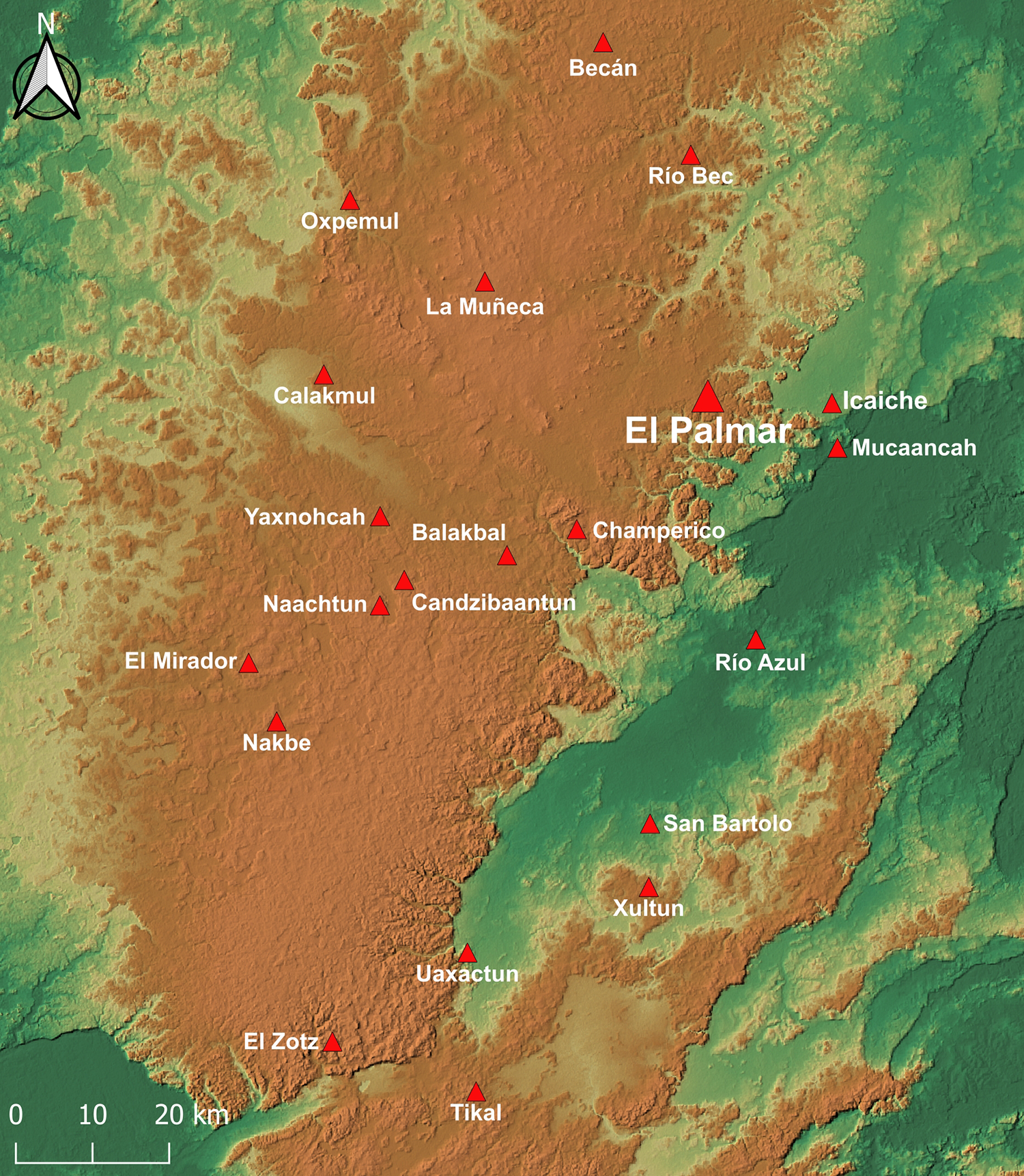
Figure 1 Long description
The map displays the Central Karstic Upland, highlighting various Maya archaeological sites. El Palmar is centrally located, surrounded by other sites such as Calakmul, Nakbe and Tikal. Each site is marked with a triangle symbol. The map includes a scale indicating distances in kilometers, ranging from 0 to 20 kilometers. The terrain is depicted with varying shades to represent elevation differences. Other notable sites include Becan, Rio Bec and Mucaancah, which are positioned around El Palmar. The map also features a compass rose in the upper left corner for orientation.
Map with the location of the Main Group and Arcos Group. Created by Kenichiro Tsukamoto © PAEP.
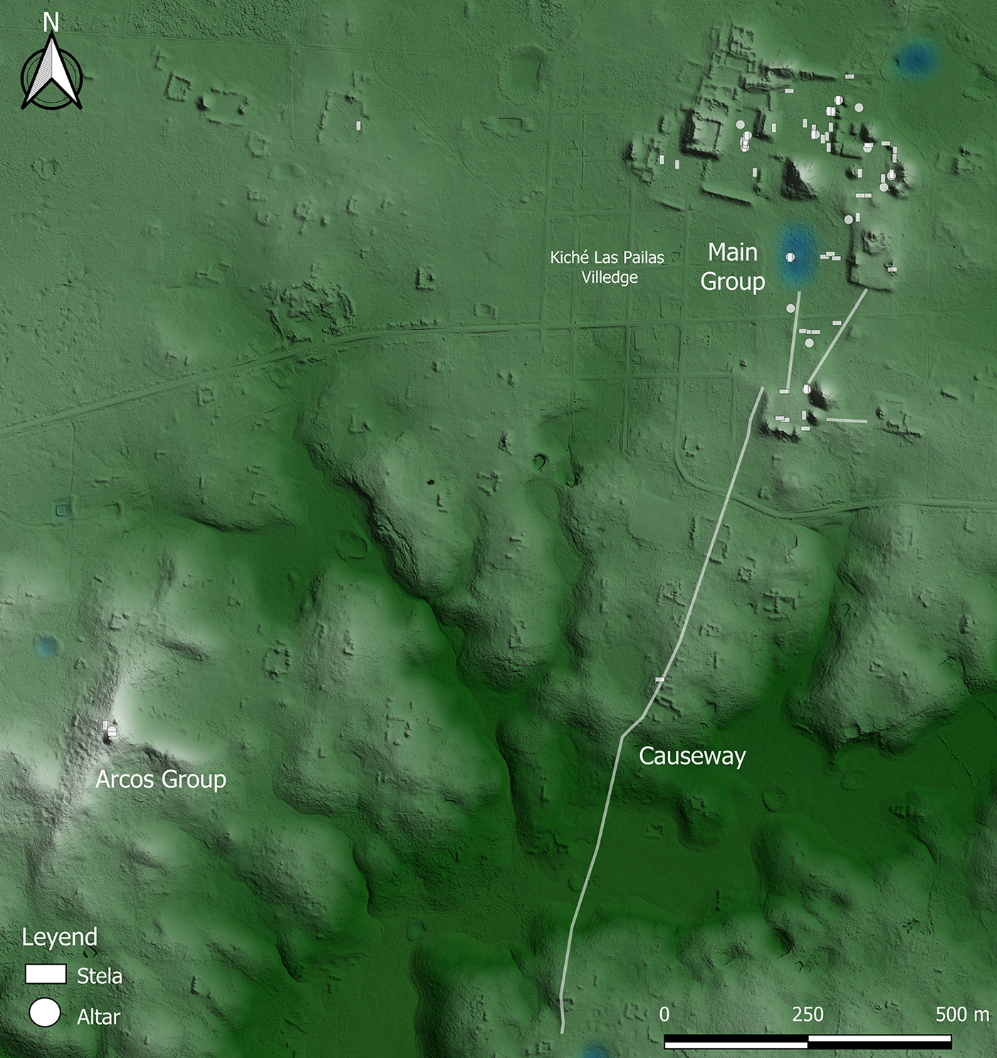
Figure 2 Long description
The map displays the Main Group and Arcos Group, connected by a Causeway. The Main Group is labeled alongside Kiche Las Palmas Village. Various stelae and altars are marked on the map. A legend indicates the symbols for stelae and altars. The map includes a scale bar showing distances in meters, with a north directional arrow at the top left corner.
Map of the Main Group with the locations of carved monuments discussed in the text. Created by Kenichiro Tsukamoto © PAEP.
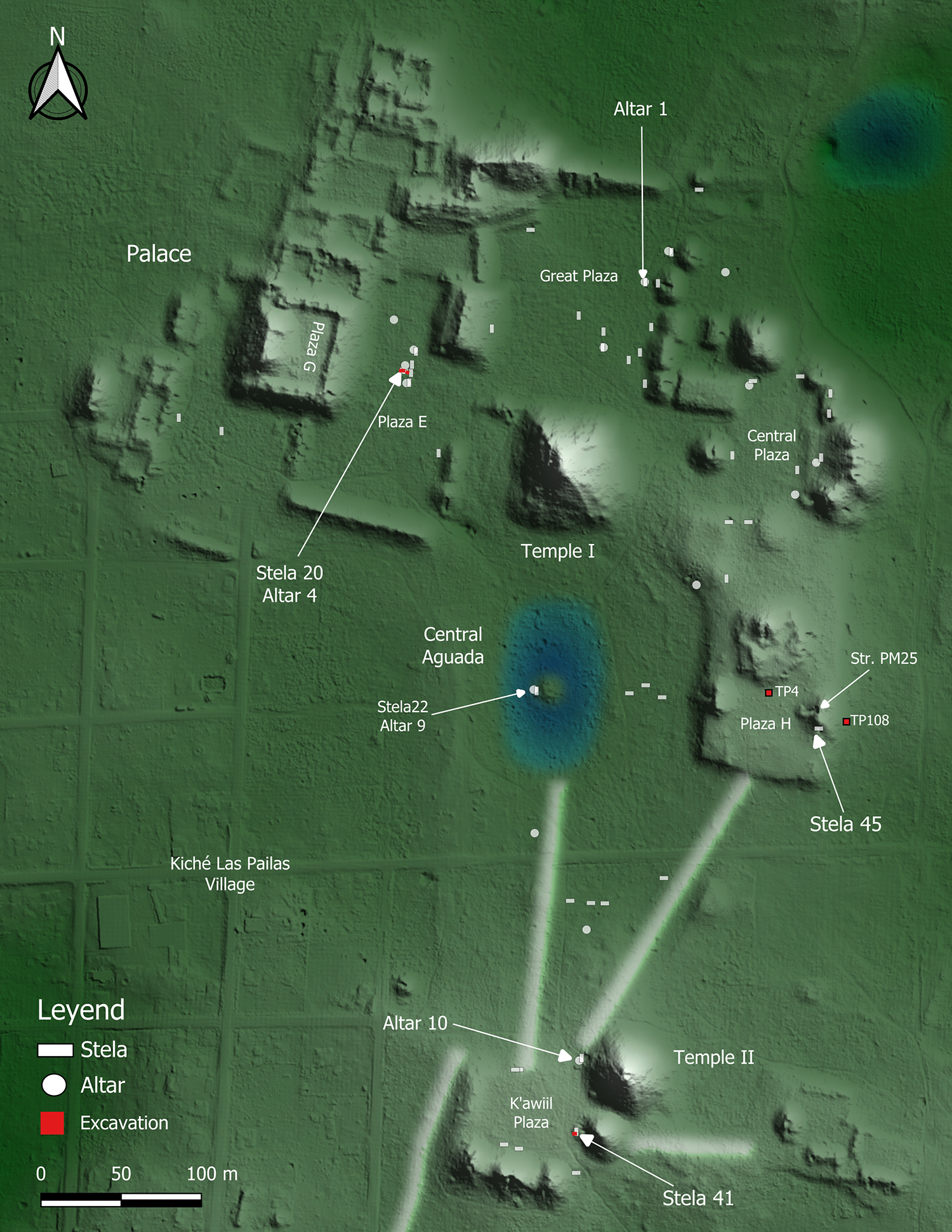
Figure 3 Long description
The map illustrates the Main Group of El Palmar, highlighting various archaeological features. Key locations include the Palace, Temple I and Temple II. Several plazas are marked, such as Great Plaza, Central Plaza, Plaza E, Plaza H and K’awiil Plaza. The map identifies stelae and altars, including Stela 20, Stela 45, Stela 41, Altar 4, Altar 7, Altar 9, and Altar 10. Central Aguada is prominently shown near Temple I. Excavation sites are marked in red. The map includes a legend indicating stelae, altars and excavation areas, with a scale ranging from 0 to 500 meters. North is indicated by an arrow at the top left corner.
El Palmar monuments with the Early to Middle Classic dates (a.d. 250–600) were reported in the 1980s. Merle Greene Robertson (Reference Robertson1984) conducted rubbing of an altar and briefly mentioned two additional stelae, which, as we mentioned earlier, Mayer (Reference Mayer1991) named Stelae 45 and 46 following Thompson’s numbering system. In his study of Early Classic monuments, Peter Mathews (Reference Mathews, Willey and Mathews1985) or possibly Edward Kujack (Robertson Reference Robertson2006:97–98) called this altar Altar 1 and dated it to 9.6.0.0.0 (March 23, a.d. 554). After this, other scholars followed this number (e.g., Carlos Brokmann Reference Brokmann Haro1997; Grube Reference Grube and Šprajc2008:231; Mayer Reference Mayer2011:67–68; Robertson Reference Robertson2006:98). However, Thompson had already plotted Altars 1 to 8 on his unpublished map (Šprajc Reference Šprajc2008:Plate 6), and later Brokmann (Reference Brokmann Haro1997) reported a new monument on a mound located in the center of the Central Aguada. Brokmann identified it as a stela, but it is in fact a round altar paired with Stela 22, which Thompson (Reference Thompson1994[Reference Thompson1963]:262–263) had reported previously. Therefore, we renamed this altar as Altar 9. Following the numbering system of Thompson and Brokmann, we corrected the name of Altar 1 to Altar 10 (Tsukamoto et al. Reference Tsukamoto, Kotegawa and Valenzuela2012). In 1985 two archaeologists from the Campeche INAH Center, Renée Lorelei Zapata Peraza (Reference Zapata Peraza1985) and Antonio Benavides Castillo (personal communication 2009), transported Stelae 45 and 46 to Campeche City to protect them from looting.
Since 2007, the Proyecto Arqueológico El Palmar (PAEP), directed by Tsukamoto and López Camacho, has relocated or newly documented 48 stelae, 18 altars, a panel, and a hieroglyphic stairway. Following Brokmann (Reference Brokmann Haro1997), we corrected Thompson’s initial documentation (Šprajc Reference Šprajc2008:Plate 6), in which some altars and the panel were identified as stelae and two fragments of the same stela were reported as two stelae. For instance, Brokmann (Reference Brokmann Haro1997) reported an altar that Thompson initially plotted as Stela 34. We renamed this monument Altar 11. Most of the stelae and altars were placed on the Main Group’s public plazas, including the Central Plaza, K’awiil Plaza, Plaza H, the Great Plaza, and Plaza E. Our excavations at the first three plazas uncovered long construction sequences beginning from the Late Preclassic period (ca. 300–75 b.c.) to the Terminal Classic (ca. a.d. 800–950), while the latter two plazas were paved during the Middle Classic (ca. a.d. 400–600). At the Central Plaza, a test excavation unearthed a long construction sequence from 359–54 cal b.c. (Table 1, AA86915) until around a.d. 900–950 (Tsukamoto et al. Reference Tsukamoto, Kotegawa and Valenzuela2012). The Central Plaza is formed by the largest pyramidal structure, Temple I, and a possible E-Group, a well-known architectural complex built across the Maya area from the Preclassic to the Terminal Classic period (Aimers and Rice Reference Aimers and Rice2006; Clark and Hansen Reference Clark, Hansen, Inomata and Houston2001; Freidel et al. Reference Freidel, Chase, Dowd and Murdock2017). Likewise, a test excavation at Plaza H exposed six floors, with the second earliest floor dating to 342 cal b.c. to cal a.d. 1 (AA86924). An urban transformation occurred at the Main Group by the end of the Middle Classic when the Maya constructed the Great Plaza and Plaza E, the two largest public spaces that could have accommodated the entire population of the El Palmar kingdom during an event (Tsukamoto Reference Tsukamoto, Tsukamoto and Inomata2014, Reference Tsukamoto and García2025). Similarly, a stratigraphic excavation in front of Stela 41 at the K’awiil Plaza uncovered a substructure consisting of a low platform with a flat-top surface, which was covered with plaster. It could have served as a masonry bench, but the excavation unit was too small to determine its type. A radiocarbon assay extracted from the plaster suggests that the Maya constructed this substructure between 51 cal b.c. and cal a.d. 63 (YU15704). By cal a.d. 361 (YU15705), a new floor sealed the platform. On March 23, a.d. 554 (9.6.0.0.0 9 Ajaw 3 Wayeb), an El Palmar ruler K’ahk’ P’uhjlaj? Chan Yopaat celebrated the sixth k’atun ending at the K’awiil Plaza and commissioned the placement of Altar 10 at the foot of Temple II (Esparza Olguín et al. Reference Esparza Olguín, Tsukamoto and Valenzuela2019; Tsukamoto and Esparza Olguín Reference Tsukamoto, Olguín, Okoshi, Chase, Nondédéo and Arnauld2021).
Three El Palmar monuments contain calendars earlier than Altar 10: Stelae 46, 45, and 20. As Mayer (Reference Mayer1991) initially reported, in 2009 Esparza Olguín and Tsukamoto confirmed the presence of 8 bak’tun on Stela 46, which was stored at the Campeche INAH Center’s Guadalupe storage in Campeche City. Stela 45 was located at the Baluarte de la Soledad Museum of the same city, and we detected Stela 20 at the Main Group’s Plaza E. When Tsukamoto and Esparza Olguín relocated Stela 20 in 2007, we thought it had been completely eroded. During the 2018 field season, however, Campaña overturned Stela 20 to examine the back face and detected inscriptions and iconographic images. Esparza Olguín and Tsukamoto (Reference Esparza Olguín, Tsukamoto and Esparza2022) published preliminary readings of the three monuments, but the readings of several glyphs remained tentative. This study introduces new readings resulting from an integrative method.
Methods
Our method combined epigraphic, iconographic, and archaeological studies. Regarding the study of carved monuments, we employed three-dimensional modeling with traditional techniques. During the 2007 and 2009 field seasons, we photographed Stelae 45 and 46 under diverse lighting conditions with a Nikon D70 digital SLR camera. Images were acquired both in daylight and under raking light at night. These photographs were used for preliminary analyses and drawings, but we recognized that artificial raking light could sometimes cause disruptive flares, glares, occlusions, and shadows (Prager et al. Reference Prager, Gronemeyer and Wagner2020). When we found inscriptions and iconographic images carved on Stela 20, we conducted photogrammetry using a Nikon D750 digital SLR camera. In 2023 and 2025, we took higher-resolution photographs with a Sony Alpha 7R full-frame mirrorless digital camera, producing approximately 200 images per lighting condition and per stela side. This camera drastically improved the clarity of each photograph. The daylight photographs were used for photogrammetric processing, and three-dimensional models were built in Agisoft Metashape Professional version 2.2.1, subsequently exported to MeshLab version 2023.12. Metashape uses hundreds of photographs to create a point cloud, color mesh models, and digital elevation models while Meshlab is open software that enhances the visibility of eroded glyphs on monuments by artificially illuminating them from multiple angles—a technique currently adopted by several epigraphers (e.g., Wahl et al. Reference Wahl, Anderson, Estrada-Belli and Tokovinine2019:1053). A rendering technique named Lit Sphere Radiance Scaling was especially useful for our study.
For Stela 46, we used a high-resolution scanner, Artec Spider II, which offers resolution and accuracy of up to 0.05 millimetres; however, the resolution of 0.1 mm was achieved in this study. The application of high-resolution 3D scanners also became common for the study of Maya hieroglyphs (Prager et al. Reference Prager, Gronemeyer and Wagner2020; Tokovinine Reference Tokovinine and Beliaev2013; Tokovinine and Fash Reference Tokovinine and Fash2008). Using Artec Spider II, Tsukamoto and Esparza Olguín conducted glyph-by-glyph scans of Stela 46 in the Guadalupe storage during the 2025 field season. We occasionally created digital elevation models (DEMs) of some glyphs through Artec Studio 19 and Golden Software Surfer 16 to scrutinize the degree of erosion. These approaches drastically improved our reading of eroded texts and iconographic images carved on the stelae. Using the photographs and models, we drew monuments and then examined and corrected them in situ.
A comparative method was employed for epigraphic and iconographic analyses. Esparza Olguín and Tsukamoto independently examined inscriptions in position; subsequently, the former author made line drawings, while the latter examined and modified them as needed. Salazar Lama and Esparza Olguín drew iconographic images, whereas Tsukamoto and Esparza Olguín took photographs and conducted 3D scanning. The iconographic styles were sorted not only to describe the images and formal characteristics but also to demarcate temporal frameworks. This was particularly necessary in cases where dates associated with Long Counts and Calendar Rounds were indeterminate due to poor preservation. We acknowledge that the temporal frameworks employed in the study of iconographic images are open to discussion in light of novel findings and evidence, yet this approach facilitated the selection of the potential range of Maya calendars.
Simultaneously, we contextualized the monuments with other archaeological data. Some of the senior local workers at the Kiché Las Pailas village still remember when Zapata Peraza and Benavides Castillo transported Stelae 45 and 46 from El Palmar to Campeche City in 1985. During the 2023 and 2025 seasons, two local workers who had collaborated with us for more than 15 years helped us find the original locations of these stelae. A former village commissioner, who organized with the INAH’s archaeologists to bring the stelae to Campeche City, also helped us. They independently brought us to those locations during the 2023 and 2025 field seasons and then we evaluated whether their locations were matched. Once those locations were confirmed and there was no prior excavation data, we conducted stratigraphic excavations to build general chronologies. Regarding Stela 20, we conducted stratigraphic excavations around it and in front of Altar 4, which is paired with the stela. For radiocarbon dating, we used the OxCal 4.4 program with the IntCal 20 calibration curve and 95.4 percent at 2 σ (Table 1).
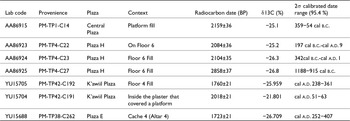
Radiocarbon dates from the Main Group at El Palmar
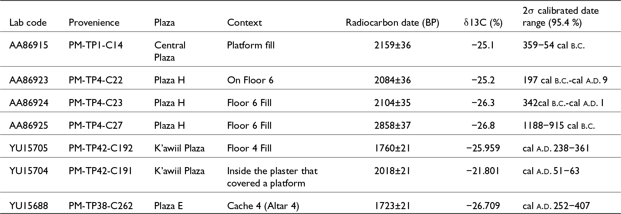
Table 1 Long description
The table presents radiocarbon dating results from various locations within El Palmar, focusing on different plazas and contexts. The radiocarbon dates range from 1188 years before the common era to 407 years after, with δ13C values indicating variations in carbon isotopic composition. Notably, the oldest date is from Plaza H, Floor 6 fill, while the most recent is from Plaza E, Cache 4. The calibrated date ranges show a wide span, suggesting diverse historical activities across the site. The δ13C values, varying from −21.801% to −26.8%, may reflect differences in environmental conditions or material types. These findings provide insights into the chronological framework and environmental context of El Palmar's archaeological deposits.
Because the IntCal 13 calibration curve was used in previous publications, some published dates for the same radiocarbon arrays differ slightly from those we used in this study (Tsukamoto et al. Reference Tsukamoto, Kotegawa and Valenzuela2012, Reference Tsukamoto, López Camacho, Evelia Campaña Valenzuela, Kotegawa and Olguín2015). The radiocarbon dates are shown as cal b.c. or cal a.d. to distinguish them from other dates. For each monument described next, we first present the results of epigraphic and iconographic studies, followed by its archaeological contexts.
Results
The epigraphic and iconographic studies of Stela 46
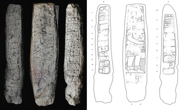
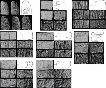
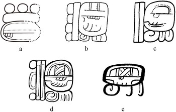
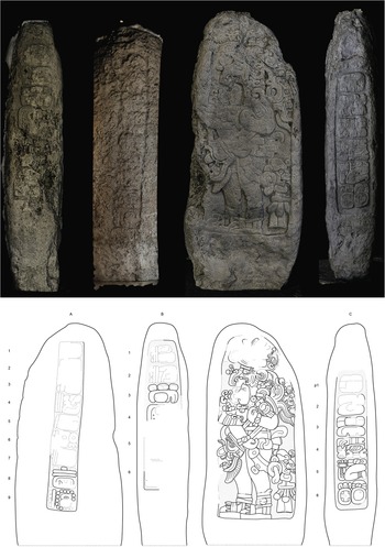
Stela 46 measures 2.96 x 0.78 m on the front face and 2.96 x 0.62 m on the sides (Figure 4). The front face represents a ruler’s effigy while the lateral sides contain inscriptions including an early Long Count and associated royal events (Columns A and B). Two additional glyphs are located beneath his feet (C1 and D1). The ruler holds the head of a deity, most likely the Jaguar God of the Underworld (hereafter JGU), who embodies the night and feline aspects of the sun (Schele and Miller Reference Schele and Miller1986; Taube and Houston Reference Taube, Houston, Houston, Newman, Román and Garrison2015). The text begins on the right lateral side (Column A), which might have contained nine glyphs (Ap1–Ap9) characterized by archaic forms (Figure 5). The upper end of this side is severely eroded and mostly broken. If a glyph (Ap1) existed there, it must have been the Introductory Glyph of the Initial Series (ISIG), preceding the Long Count. The subsequent five glyphs (Ap2–Ap6) depict the Long Count, but only numerals for the bak’tun (8) and k’atun (7) periods are clearly identifiable. The bak’tun glyph (Ap2) represents a “sky” or CHAN sign, a variant that has been documented at several sites including Chichén Itza, Dos Pilas, Naranjo, Palenque, and a panel of Kuna-Lacanjá exhibited at Dumbarton Oaks (Macri and Looper Reference Macri and Looper2011; Stuart Reference Stuart2005), and this is the earliest case (Figure 6).
Stela 46. Left side, front face, and right side. Three-dimensional modeling by Kenichiro Tsukamoto, epigraphic drawing by Octavio Q. Esparza Olguín and Kenichiro Tsukamoto , and iconographic drawing by Daniel Salazar Lama © PAEP.
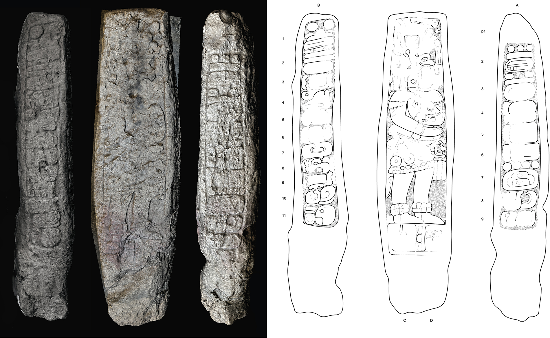
Figure 4 Long description
The image shows two parts. The left side displays a three-dimensional model of Stela 46, featuring its left side, front face and right side. The stela includes inscriptions and a ruler's effigy. The right side presents an epigraphic and iconographic drawing of the same stela, detailing the inscriptions and the ruler holding a deity's head. The drawings highlight the glyphs and the ruler's attire, with columns labeled A, B, C and D. The stela's dimensions and glyphs are depicted, emphasizing the historical and cultural significance of the inscriptions.
Glyph-by-glyph three-dimensional models with varying lighting angles carved on Stela 46, Column A. Three-dimensional modeling using Artec Spider II created by Kenichiro Tsukamoto and epigraphic drawing by Octavio Q. Esparza Olguín and Kenichiro Tsukamoto© PAEP.
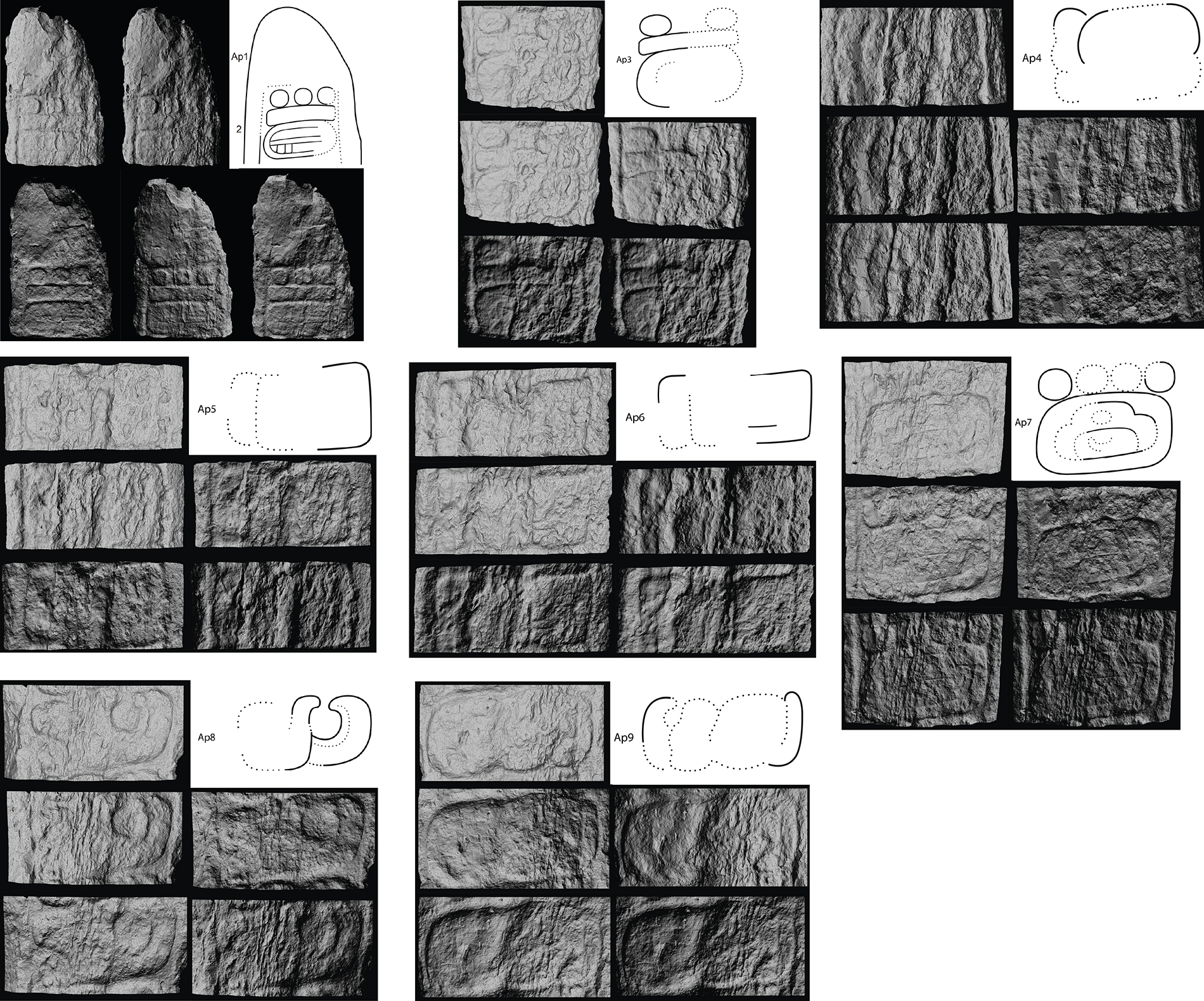
Figure 5 Long description
The image shows multiple sections of carved glyphs on stone surfaces, each accompanied by line drawings. The carvings are detailed and vary in complexity, with some sections showing multiple glyphs grouped together. The line drawings provide a clearer outline of the glyphs, highlighting their shapes and forms. Each section is distinct, showcasing different glyph arrangements and styles. The carvings appear to be part of a larger set, possibly representing a sequence or narrative.
The “sky” variant of the bak’tun period in El Palmar, Stela 46 [a] (Drawing by Octavio Q. Esparza Olguín), and other monuments: (b) Lacanha, Panel 1; (c) Naranjo, Stela 1; (d) Temple XIX platform; (e) Dresden Codex (drawings by David Stuart Reference Stuart2005).
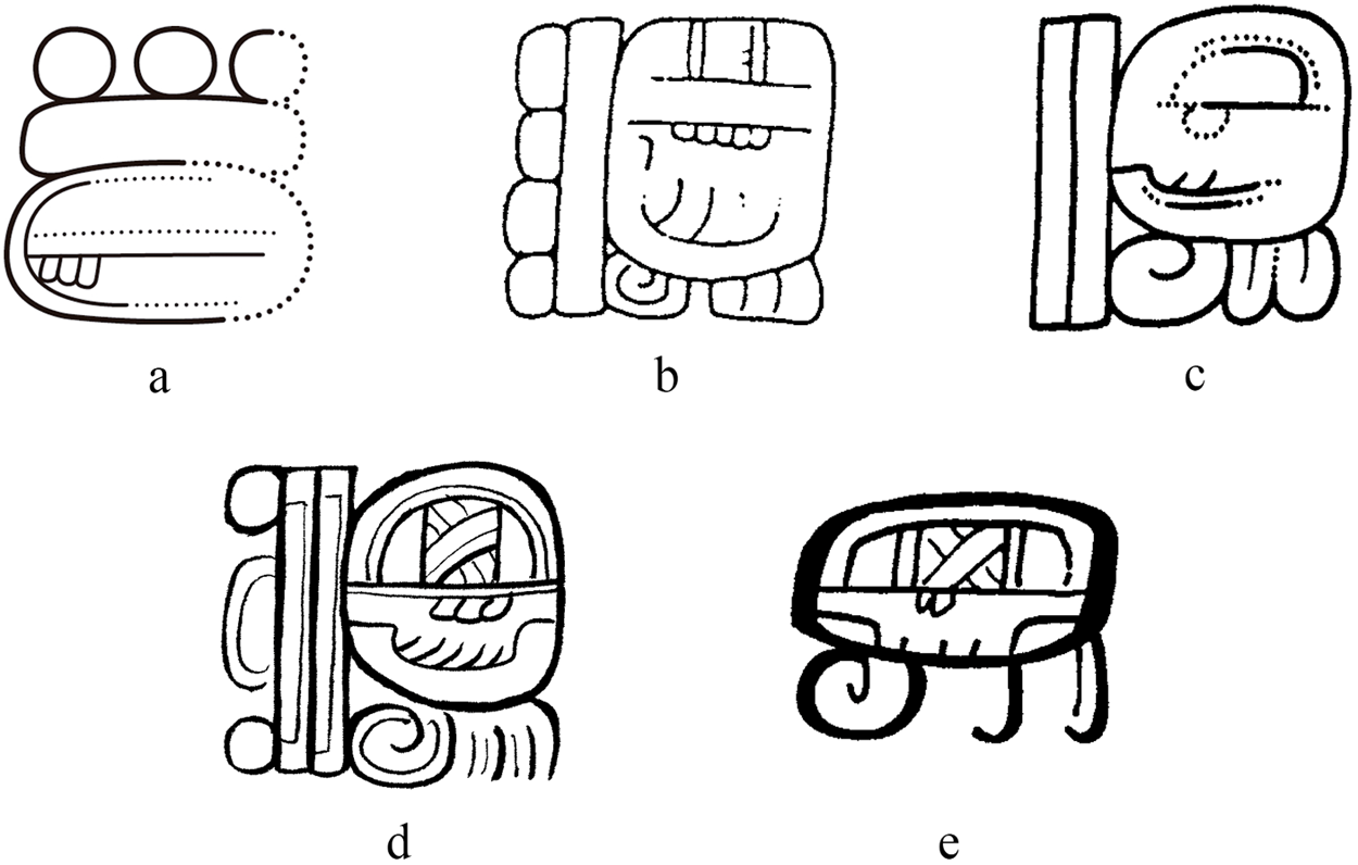
Figure 6 Long description
The image shows two glyph illustrations labeled a and b. Illustration a features a rounded design with three circular elements on top and a dotted outline. Illustration b displays a more rectangular shape with intricate line patterns and a vertical orientation. Both glyphs have unique stylistic elements.
Following 7 k’atun, the remaining numerals are badly eroded, thereby complicating the precise identification of the specific date. Nevertheless, the well-preserved glyph Ap7 represents the 260-day divinatory calendar, or tzolk’in date, of 4 Ajaw. The Ajaw sign has an archaic form reminiscent of those carved on a Kaminaljuyú jade earspool (Kidder et al. Reference Kidder, Jennings and Shook1946) and unprovenanced jade celts (Montgomery Reference Montgomery2000). The coefficient of k’in for 4 Ajaw remains fixed at 0 and no haab period is observed. The incomplete Long Count 8.7.?.?.0 4 Ajaw allows up to 28 possible combinations of Long Counts. During the initial examination of the stela in 2009, Esparza Olguín and Tsukamoto (Reference Esparza Olguín, Tsukamoto and Esparza2022:57) observed that the shapes of the coefficients for tun, winal, and k’in resemble a flower that typically represents a variant of the number 0. Therefore, they believed that the Long Count should have been 8.7.0.0.0 (a.d. 179). However, this Long Count does not correlate with 4 Ajaw and we had to reexamine other numerical options for tun and winal.
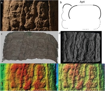
The 3D models enhanced the visibility of partially preserved coefficients of tun and winal. In terms of the tun period, the top end of the number has a curving shape that should be either 0 or the decoration of 1 (Figure 7). If this is the case, only two Long Counts 8.7.1.0.0 and 8.7.1.13.0 can correlate with 4 Ajaw. Since the preserved area of the winal period cannot accommodate the number 13, the latter is implausible. Alternatively, the number of the winal may represent a bar, meaning the number 5. If this is the case, the candidate of the Long Count corresponds to 8.7.0.5.0 4 Ajaw 13 Ch’en (December 15, a.d. 179). However, the 3D models and contours derived from them show a more rounded shape than the standard elongated rectangular shape of the bar or 5. Therefore, it is probable that the Long Count carved on Stela 46 was 8.7.1.0.0 4 Ajaw 8 Sotz (August 31, a.d. 180), although we do not preclude the possibility of other Long Counts such as 8.7.0.5.0. If our reading is correct, the Long Count of El Palmar Stela 46 dates 112 years earlier than the Long Count of Tikal Stela 29 (a.d. 292).
Three-dimensional models of glyph Ap4. (a) Photo taken with Nikon D70; (b) Line drawing; (c) Three-dimensional model created with Artec Spider II; (d) Three-dimensional model with rendering of Lambertian Radiance Scaling; (e) DEM created based on the three-dimensional model; (f) DEM with contours. Created by Kenichiro Tsukamoto © PAEP.
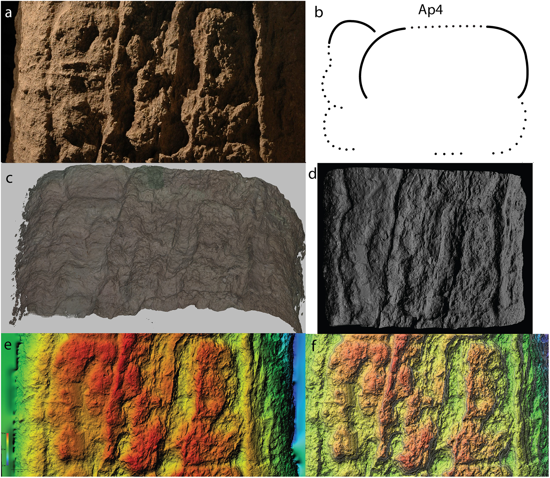
Figure 7 Long description
The image A shows a photo of glyph Ap4 taken with a Nikon D70, displaying the texture and details of the surface. The image B shows a line drawing of glyph Ap4, highlighting its outline and key features. The image C shows a three-dimensional model of glyph Ap4 created with Artec Spider II, providing a detailed view of its structure. The image D shows a three-dimensional model with rendering of Lambertian Radiance Scaling, enhancing the surface details. The image E shows a digital elevation model (DEM) created based on the three-dimensional model, illustrating the topography. The image F shows a DEM with contours, further detailing the elevation changes and surface features.
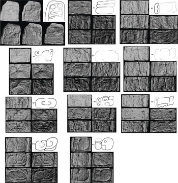
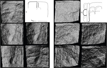
Two royal events were carved on Stela 46. The first event is linked to the Long Count and the Tzolk’in date. Glyph Ap8 is a verb with the well-known suffix -ja, which is associated with the passive voice for transitive roots. The glyph block’s other part is heavily eroded, but it may record CH’AM?-ja, ch’ahmaj?, “it was grabbed/taken/received.” Part of the glyph referring to the object is too eroded to read, but it most likely represented a head of the Jaguar God of the Underworld (JGU) that the ruler holds. An alternative reading is tz’ahpaj, “it was erected,” but this is less plausible. The following glyph Ap9 is heavily eroded, but it appears to introduce the second event. It could read u-TZ’AK?, utz’ak[aj]?, “it is set in order,” followed by a possible Distance Number (DN) on the first two glyphs of the left side (Column B), although it is also possible that the glyph depicts the object that was received or grabbed. Glyphs B1 and B2 have an arrangement similar to that of a distance number, consisting of a numeral and a main sign (Figure 8). The first of these represents 2 k’atun. The second bears the number 10, but its main sign preserves only its round outline similar to the tun period. Thus, the reading of B1 and B2 could be 2-WINIKHAAB 10-HAAB. If this is the case, the DN does not follow an ascending order as in most inscriptions. However, similar examples have been reported in other monuments such as Pol Box Stela 2 (Esparza Olguín and Gutiérrez Pérez Reference Esparza Olguín and Gutiérrez Pérez2009). The next glyph is problematic due to erosion (B3), but based on the syntax of the hieroglyphic text, we have two viable options. First, a verbal root with the third person ergative prefix /u-/, followed by the name and titles of the individual who carried out the action. Second, and more probably, a temporal marker, u-ti?-ya, uhtiiy?, “it happened.” In fact, the right end of the glyph block most likely represents the suffix ya, although it is eroded. If this is the case, the DN counts backward from the Long Count (8.7.1.0.0, as more secure), meaning that the date corresponds to 8.4.11.0.0 9 Ajaw 18 Pax (May 20, a.d. 131). If this latter hypothesis is correct, then the verb would be placed in B4 with the phrase CH’AM?-K’AWIIL?, ch’am k’awiil?, “He grabs K’awiil?,” a well-known expression of receiving political authority or accession to the throne. Although glyph B4 is heavily eroded, it has a similar shape of extended hand, a diagnostic form of the verb ch’am. Glyphs B5–B10 should be the ruler’s name, but they are extremely weathered and complicated that we could read them in part, ?-AJAW? ?-? K’AL? u-BAAH u-?-na-ne? ?-?. We tentatively call this ruler Ajaw K’al Ubaah. Glyph B11 is critical because it depicts one of El Palmar’s dual royal titles SAK-o, sak[ho’ok]?, “White Valley,” which was inherited by subsequent El Palmar rulers until at least a.d. 820 (Esparza Olguín and Tsukamoto Reference Esparza Olguín, Tsukamoto, de Velasco and Vega2011; Tsukamoto and Esparza Olguín 2015:39–45). Some researchers have proposed that this title is read as sak muk, assigning the glyph T694 the reading value MUK (Bíró et al. Reference Bíró, MacLeod and Grofe2020). However, we have not so far identified syllabic substitutions such as mu-ka in the El Palmar corpus. For this reason, we prefer to use the reading we have employed in previous texts. The royal title continues in glyphs C and D that are located beneath the ruler’s feet on the front face (Figure 9). While the glyphs are mostly eroded, glyph D preserves the number 6 that seems to be the second part of El Palmar’s royal title, 6-PIIT-AJAW, wak piit ajaw, “the lord of six litters.” Thus, the texts account for two historical events: the El Palmar ruler Ajaw K’al Ubaah acceded to the throne in a.d. 131. Forty-nine years later, in a.d. 180, he commissioned to erect the stela, performing a royal ritual.
Glyph-by-glyph three-dimensional models with varying lighting angles carved on Stela 46, Column B. Three-dimensional modeling using Artec Spider II created by Kenichiro Tsukamoto and epigraphic drawing by Octavio Q. Esparza Olguín and Kenichiro Tsukamoto© PAEP.
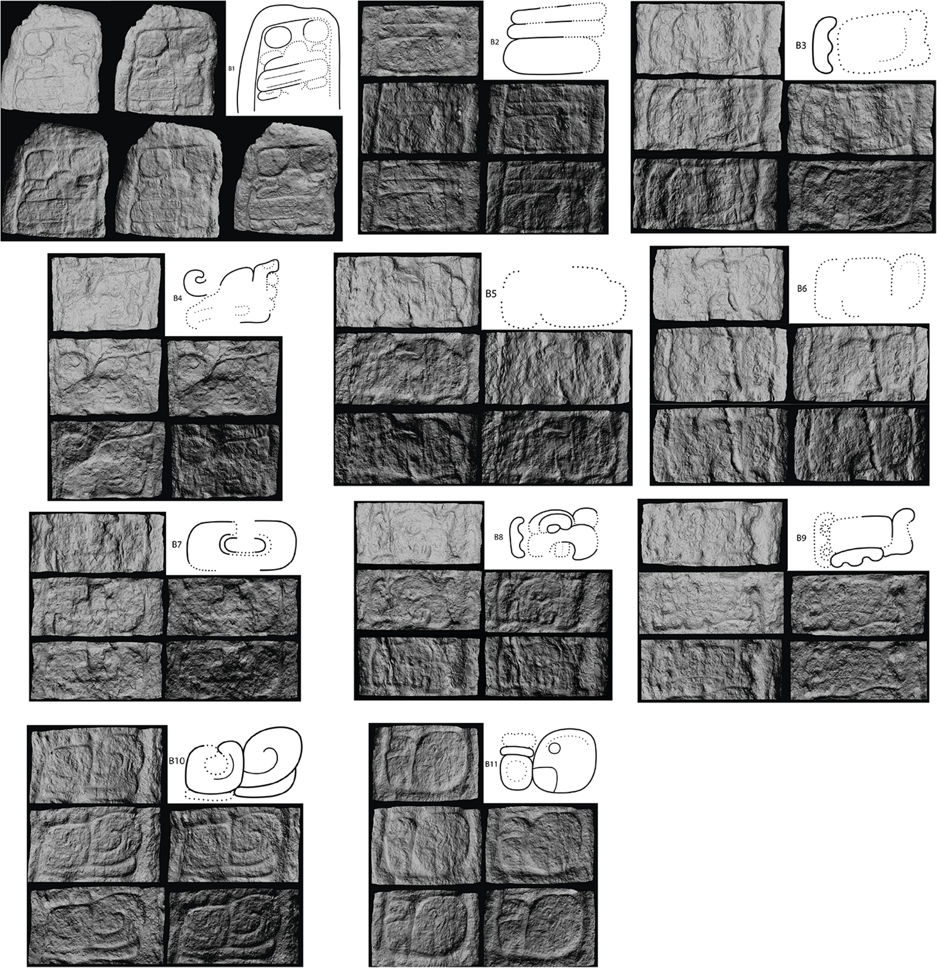
Figure 8 Long description
The image consists of 11 sets of glyph images, each displaying carved glyphs alongside corresponding drawings. Image 1 shows four carved glyphs with a drawing illustrating their design. Image 2 features three carved glyphs with a drawing depicting their structure. Image 3 presents three carved glyphs with a drawing outlining their form. PImage 4 includes three carved glyphs with a drawing showing their design. Image 5 displays three carved glyphs with a drawing illustrating their structure. Image 6 features three carved glyphs with a drawing depicting their form. Image 7 presents three carved glyphs with a drawing outlining their design. Image 8 includes three carved glyphs with a drawing showing their structure. Image 9 displays three carved glyphs with a drawing illustrating their form. There are two more sets of images. Each set of images highlights the intricate details and interpretations of the glyphs through the accompanying drawings.
Glyph-by-glyph three-dimensional models with varying lighting angles carved on Stela 46, glyphs C and D. Three-dimensional modeling using Artec Spider II created by Kenichiro Tsukamoto and epigraphic drawing by Octavio Q. Esparza Olguín and Kenichiro Tsukamoto © PAEP.
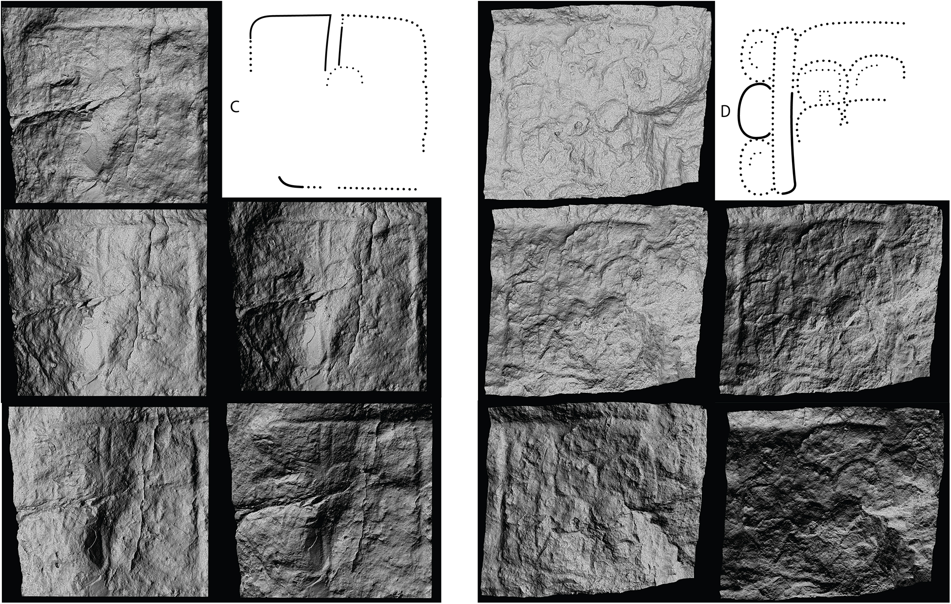
Figure 9 Long description
The image shows two sets of stone carvings. The left set contains three vertically aligned stone panels with visible carvings. Above these, a dotted outline labeled C is present. The right set also has three vertically aligned stone panels with carvings, accompanied by a dotted outline labeled D. The carvings appear to be intricate and detailed, with the outlines suggesting specific glyph shapes or symbols.
Iconographic elements support our reading of the Long Count that Stela 46 was erected during the Protoclassic or Terminal Preclassic period (75 b.c. to a.d. 250). The disembodied deity head in the rulers’ arms was an essential element of royal paraphernalia during the 8 bak’tun period and became less frequent after the turn of 9 bak’tun (Clancy Reference Clancy1999). Uaxactun Stela 9 (8.14.10.13.15) and Stela 4 (8.18.0.0.0), and Uolantun Stela 1 (8.18.13.5.11 or 9.19.0.0.0) represent rulers holding a deity’s head. A later example is Tikal Stela 31 (a.d. 445), in which the king Sihyaj Chan K’awiil II holds a disembodied JGU head as the tutelary god of the royal lineage, a similarity Robertson (Reference Robertson1984) had reported earlier. Stela 46’s schematic renderings of the human body were typical between a.d. 100–300 (Miller and O’Neil Reference Miller and O’Neil2014). They include simplified hands and feet, occasionally with undetailed thick legs. These elements often entail a conventional rendering such as both feet pointing in one direction and slightly overlapped, legs apart at the knee level, and shoulders in the front view (Proskouriakoff Reference Proskouriakoff1950). Also, the ruler Ajaw K’al Ubaah wears an elaborate feathered headdress incorporating a zoomorphic head, probably a feline on the front side. He also wears a beaded, trellis-patterned skirt that first appeared on Tak’alik Ab’aj Altar 13 in the first century a.d. (Graham et al. Reference Graham, Heizer, Shook and Graham1978). The head of the rain god Chaahk was attached to the skirt’s front, with three elongated celt-like objects hanging from its chin. Although the ruler faces to the right, which is uncommon in Maya art, there are early examples such as La Mojarra Stela 1 and Chalchuapa Monument 1. It was not until the Early Classic period that the leftward orientation of figures became standardized (Grube Reference Grube2023:16).
The archaeological context of Stela 46
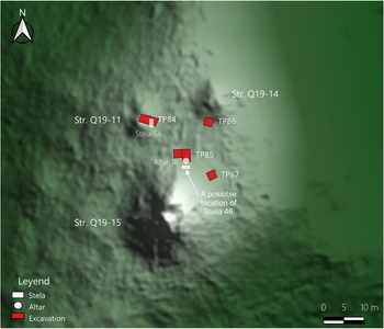
According to Robertson (Reference Robertson1984) and Zapata Peraza (Reference Zapata Peraza1985), Stela 46 was recovered from a looter’s trench dug into a vaulted room of a pyramidal structure at a site close to El Palmar’s Main Group. In seeking the original location of Stela 46, all three senior persons from the Kiché Las Pailas village independently brought us to the same architectural group that is located 1.6 km southwest of El Palmar’s Main Group. Tsukamoto and López Camacho documented this architectural group during the initial fieldwork conducted in 2007 and designated it as the Arco Group, using the landowner’s surname (Tsukamoto et al. Reference Tsukamoto, López Camacho and Olguín2010). During the 2025 field season, however, Tsukamoto noticed that the correct surname was “Arcos,” and consequently, we have renamed it accordingly in this article. It had never been excavated until 2025. The Arcos Group consists of a plazuela (i.e., a small plaza compound) situated on a hilltop and comprises three structures that form a small plaza (Figure 10). Structure Q19-15 is a pyramidal structure that closes the plaza’s south end. This is probably a temple due to its pyramidal shape, which measures 25 x 25 m at its base and 12 m in height. At the north foot of the structure, we found a new altar, which we documented as Altar 18. Altar 18 was heavily eroded and broken into two pieces. No iconographic images and glyphic texts were observed. Structure Q19-15 had three looters’ trenches on the upper part of the facades. These trenches are all collapsed and none of them exposed a vaulted chamber. As we mentioned before, the pyramidal shape of the mound suggests that the structure originally had a temple with a vaulted room on its top.
Map of the Arcos Group. Created by Kenichiro Tsukamoto © PAEP.
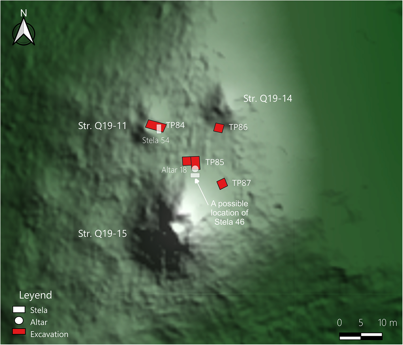
Figure 10 Long description
A map displays an archaeological site with several labeled structures and excavation points. Structures Q19-11, Q19-14 and Q19-15 are marked. Stela 54 and Altar 18 are identified near Structure Q19-11. Excavation points TP84, TP85, TP86 and TP87 are shown, with a note indicating a possible location of Stela 46. A legend indicates symbols for stela, altar and excavation. A scale bar is present at the bottom right, showing measurements in meters.
While all the informants agreed with Stela 46’s general location at the Arcos Group, their precise locations varied. One local worker indicated that Stela 46 was found in the middle of Structure Q19-15, facing the Main Group. Another worker located it 2 m north of Structure Q19-11, a low structure closing the plaza’s west end. This structure also had a looter’s trench along its central axis, exposing the main entrance where a stela (Stela 54) still stands. Cleaning the looter’s trench uncovered jambs forming the doorway that led to a room. The excavation recovered capstones and vault stones, building materials indicating that the room was originally vaulted. At the place to the north of the structure, as indicated by one of the senior workers, we did not find any evidence associated with Stela 46. We suspect that he saw Stela 46 was there when it had already been moved from the original location for loading onto a pickup truck. Structure Q19-11 appears to have a single chamber in which Stela 54 stands, and therefore, the room interior has no space to place Stela 46. The other candidate is Structure Q19-14 which is a small square mound closing the plaza’s north end. There was a looter’s trench at its northeast side, but no evidence of a vaulted room was found during fieldwork. Campaña asked the third person in 2023, but he could not bring her to the stela’s precise location because heavy vegetation prevented them from visiting the Arcos Group. At this moment, the potential structure associated with Stela 46 was Structure Q19-15, but horizontal excavations are necessary to assess it.
To contextualize Stela 46 in the site chronology, we conducted stratigraphic and trench excavations in front of each structure and a 2 x 2 m test pit at the northeast corner of the main pyramidal structure Q19-15 during the 2025 field season. Radiocarbon dating is still underway, but the excavations and subsequent ceramic analyses provided preliminary results about the archaeological contexts of Stela 46. The three excavations at the plaza exposed three floors. Ceramic assemblages recovered from the construction fill of the earliest floor dated to the Terminal Preclassic period (75 b.c. to a.d. 250). While most sherds were Late Preclassic types such as Sierra Red, Polvero Black, and Sapote Striated, the stratum also contained a few Terminal Preclassic sherds including a base fragment of Ixcanrio Orange Polychrome, a diagnostic type of the Terminal Preclassic. We recovered this polychrome fragment within a chultun found at the bottom of TP87, a test pit located at the northeast corner of Structure Q19-15. The attributes of ceramic vessels found in a cache (Cache 7) also characterize a transition between the Terminal Preclassic and the Early Classic. Cache 7 was recovered from a 2 x 2 m test pit (TP86) located in front of Structure Q19-14. It contained lip-to-lip orange bowls and two brown eccentric flints. We sorted these bowls as a transitional type between Sierra Red and Aguila Orange. The orange slip corresponds to the Aguila Orange type, but the ware is waxy rather than glossy. The vessel forms resemble Sierra Red with outcurved walls and thickened rims. We did not find anything inside the lip-to-lip bowls. The Arcos Group appears to have been abandoned during the Early or Middle Classic period (a.d. 250–600), but people reoccupied this place during the Late to Terminal Classic (a.d. 600–950).
The epigraphic and iconographic studies of Stela 45
Stela 45 provides insights into El Palmar kingship in the fourth century a.d. (Figure 11). The stela has three textual columns; one carved on the back face and the others on the lateral sides. The inscriptions begin on the back face with the Long Count 8.15.5.8.11 13 Chuwen 9 Mol or October 12, a.d. 342 (A1–A8). Our reading remains tentative because the stela is currently on display at the Fuerte de San Miguel Museum, where it is mounted against the wall, making it impossible to examine the texts directly. Tsukamoto took several photographs of the back face by inserting his hand with a cell phone camera into the narrow space. We combined these photographs in Agisoft Metashape to create a 3D model, which was exported to Meshlab for epigraphic studies. Mayer (Reference Mayer1991:Plate 33) published a photograph of the back face when it was still located outside. The glyphs in the photograph are unclear, but they helped us confirm the number of glyphs in the column.
Stela 45. Back face, left side, front face, and right side. Three-dimensional modeling by Kenichiro Tsukamoto, epigraphic drawing by Octavio Q. Esparza Olguín and Kenichiro Tsukamoto, and iconographic drawing by Daniel Salazar Lama © PAEP.
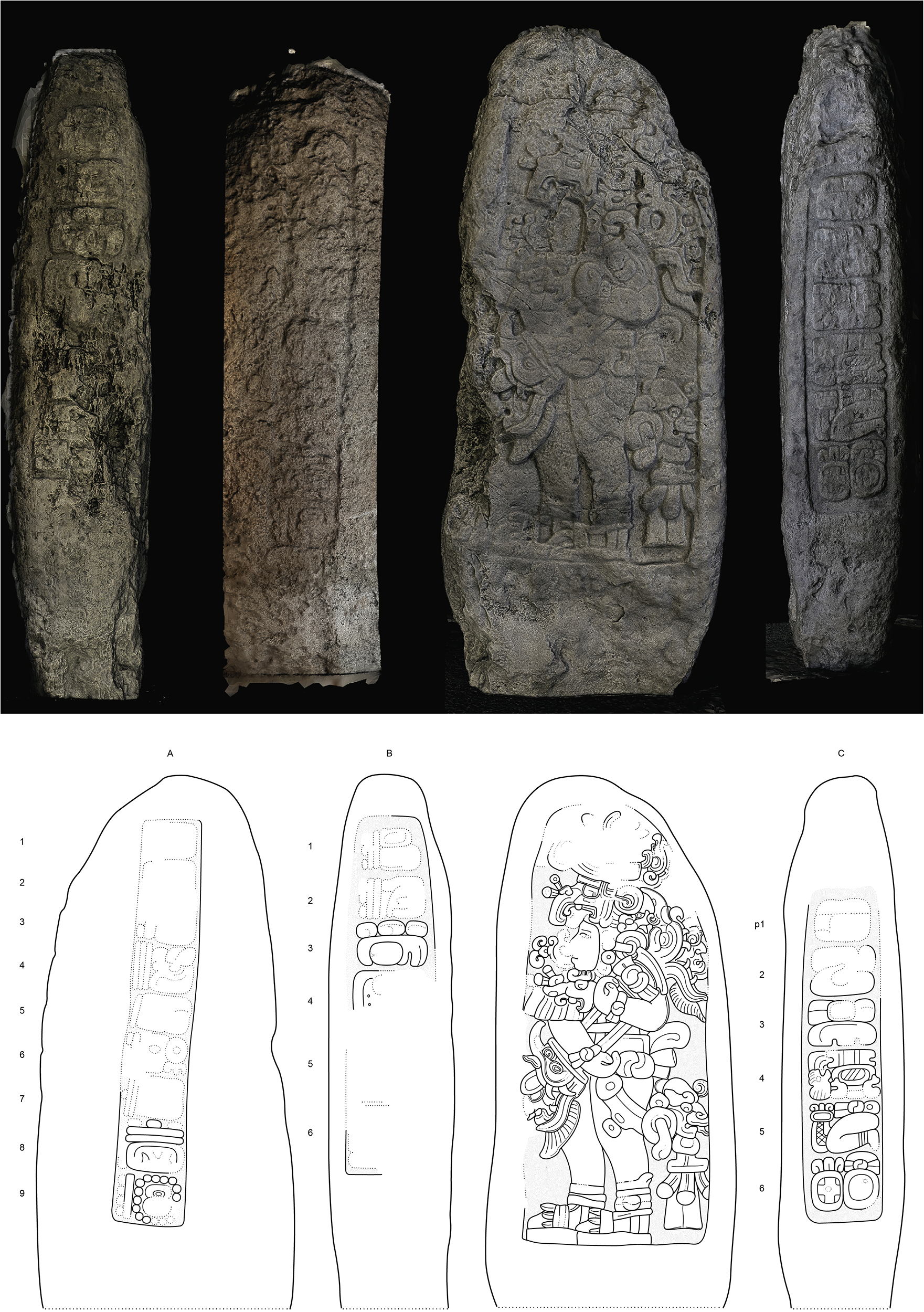
Figure 11 Long description
The image shows four views of a stela, each with intricate carvings. The top row displays photographs of the stela from different angles: back face, left side, front face and right side. Each face features detailed carvings, including glyphs and figures. Below, corresponding line drawings illustrate the carvings on each side, labeled A, B and C. The drawings highlight the glyphs and figures, providing a clearer view of the stela's intricate designs.
Glyphs A1 and A2 must be an introductory glyph (ISIG), but it is too eroded to recognize the patron of the month. The following bak’tun period (A3) is partially preserved, representing the number 8. The better-preserved numbers correspond to k’atun (A4) and tun (A5), which are 15 and 5, respectively. Winal appears to be higher than 5 (A6), but it is partially eroded. In A8, we have the record of day Chuwen with the number 13 (which indicates that the coefficient of the k’in position is 11 [A7]), while in A9 we can read the haab date with confidence as 9 Mol. The calendar date that can contain 8.15.5.?.11 13 Chuwen 9 Mol is 8.15.5.8.11 (October 12, a.d. 342). Column B on the left side depicts the Supplementary series, as the glyph block B3 clearly represents a lord of the night G9. We are puzzled by glyphs B1 and B2, which both appear to contain the number 13, but they are too eroded to read. Glyphs B4–B6 and Cp1 are in the extreme poor state of preservation. Better preserved are the following glyphs Cp2–Cp6 which record K’AL?-SAK? HUUN-na tz’u-CHAK-AHK ch’a-hi-A’ K’AN-?, k’al sak…huun tz’u chak ahk ch’aaha’?…k’an…, “The white paper headband of Tz’u Chak Ahk Ch’aaha’?…K’an…is bound,” another expression of royal accession. The reading ch’aaha’ was proposed by Grube et al. Reference Grube, Prager, Wagner and Krempel2024, although its meaning is uncertain. We tentatively call this ruler Tz’u Chak Ahk.
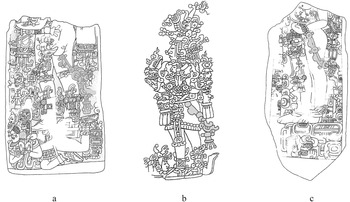
The ruler Tz’u Chak Ahk is portrayed on the stela’s front face and his posture attests to the continuity of iconographic elements inherited from Stela 46. He stands with his feet pointing in one direction slightly overlapping, and his arms are bent at an acute angle, holding a ceremonial bar in the crook of his left arm while simplified hands are clenched. The king wears a headdress composed of a pair of heads of supernatural beings with a prominent nose and beak, one of which is the Principal Bird Deity, wristbands, sandals, and a kind of knotted truss from which a distinctive belt chain hangs with the head of Chaahk at the height of his thighs (García Barrios Reference García Barrios2023). These elements are almost identical to those found on the Leiden plaque and Tikal Stelae 39, which date to a.d. 320 and 376, respectively (Beliaev and De León Reference Beliaev and de León2013:108–109). Notably, the chain with a yax-like sign has an early form, which dates to a.d. 320–416 (Lacadena Reference Lacadena García-Gallo1995), a time range that accords well with the Long Count of El Palmar Stela 45 (Figure 12). Two deities emerge from the serpent heads of the ceremonial bar. The right end head may represent the conflation of the Jaguar Paddler God and JGU while the left end shows the solar deity K’inich Ajaw, with features resembling those of the solar deity of dawn, GI. These gods probably represent the nocturnal/diurnal duality of the sun.
Examples of Early Classic monuments belt chains: (a) Tikal, Stela 35 (after Schele and Freidel Reference Schele and Freidel1990: 145, Figure 4:14); (b) Leyden plaque (after Linda Schele and Freidel Reference Schele and Freidel1990: 142, Figure 4:12); (c) Uxbenka, Stela 11 (after Wanyerka Reference Wanyerka2003; original drawing by John Montgomery). Modified by Daniel Salazar Lama.
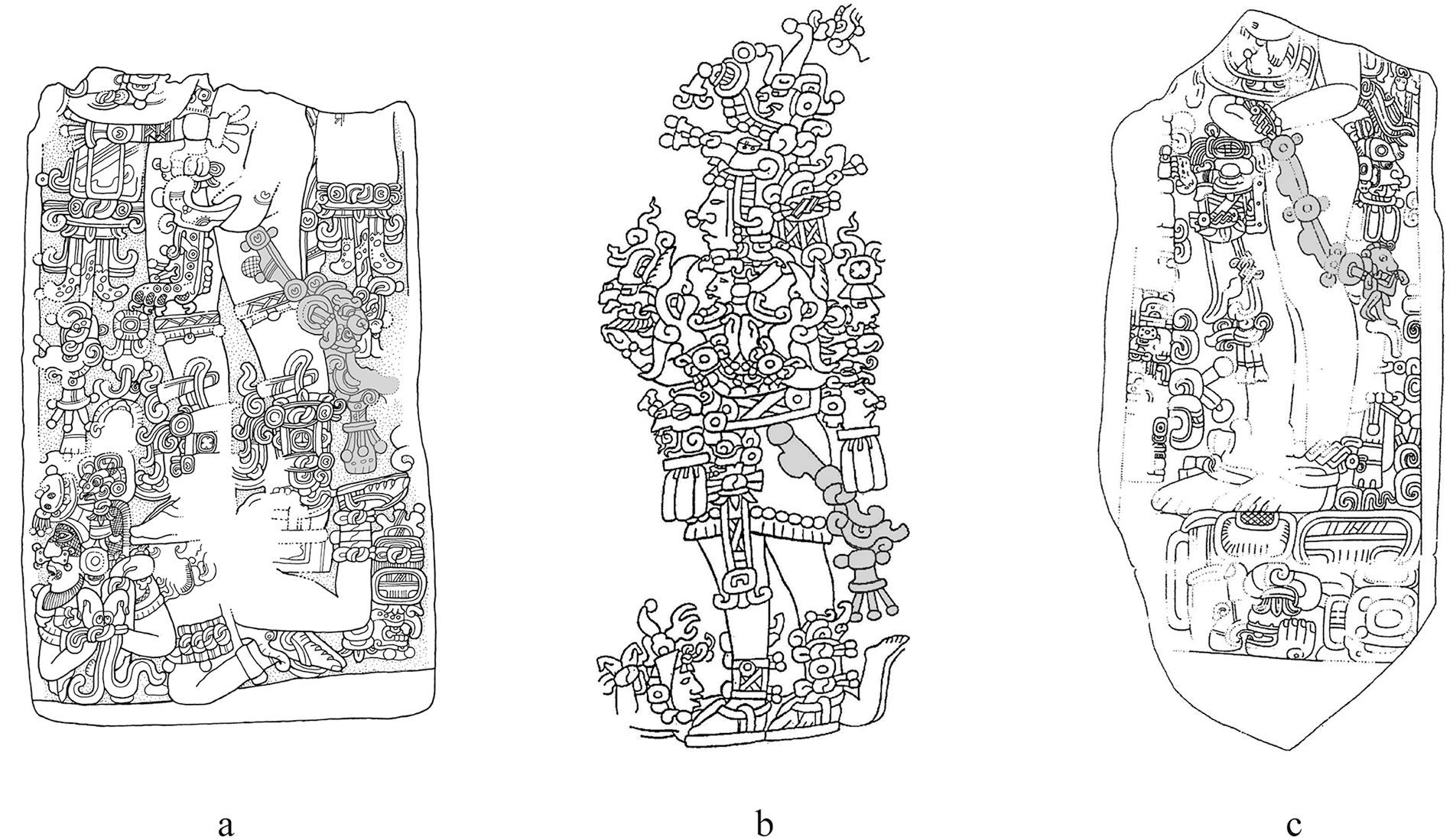
Figure 12 Long description
The image shows three detailed illustrations of Early Classic monuments. Illustration a depicts Tikal, Stela 35, featuring intricate carvings and patterns. Illustration b shows a standing figure with elaborate headdress and attire, possibly representing a ruler or deity, with complex iconography. Illustration c presents Uxbenka, Stela 11, with detailed carvings and symbolic elements. Each illustration is rich in detail, showcasing the artistic style of the period.
The archaeological context of Stela 45
We attempted to find the original location of Stela 45 during the 2025 field season. Zapata Peraza (Reference Zapata Peraza1985:4) reported that the stela was found at the east of the Main Group, although he suspected that it had been moved from the original location. All three people at K’iche Las Pailas told us that the stela was originally found near Structure PM25, which closes the east end of Plaza H at the Main Group, the location roughly matched that of Zapata Peraza. The stela might have been moved, but it must have been erected on Plaza H since the plaza is conditioned on the Great Platform, an elevated platform about seven meters above the surrounding ground surface. It is highly unlikely that looters or other people brought this heavy stone monument from elsewhere to the Great Platform.
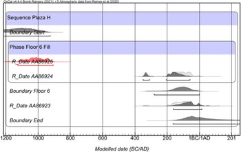
During the second field season in 2009, we conducted a 2 m x 2 m test pit (TP4) on Plaza H, which exposed seven floors from the Late Preclassic to the Terminal Classic (Tsukamoto et al. Reference Tsukamoto, Kotegawa and Valenzuela2012). Three charcoal samples were recovered; two from the second-earliest floor (Floor 6) fill and the other on the floor. A Bayesian model created by these radiocarbon assays suggests that Floor 6 was paved between 282 cal b.c. and cal a.d. 1 (Figure 13). Floor 5 covered Floor 6 during the Early Classic period (a.d. 250–400). Stela 45 was probably erected around Structure PM25 when Floor 5 was still used. During the Late Classic period (a.d. 600–800), a new floor (Floor 4) covered Floor 5. In 2025 we excavated a 2 x 2 m test pit (TP108) behind Structure PM25 and recovered a rich Early Classic midden deposit under a well-compacted surface composed of gravel and gray sandy soil, on which a Late Terminal Classic midden was also found. Unlike other midden deposits found at El Palmar, artifacts in this Early Classic midden deposit were mostly eroded, suggesting that people constantly threw trash which was exposed during that period. When one of the subsequent floors was paved, people sealed the midden and compacted the ground surface.
Bayesian model that refines the construction timing of Plaza H’s Floor 6 at the Great Platform. Created by Kenichiro Tsukamoto © PAEP.
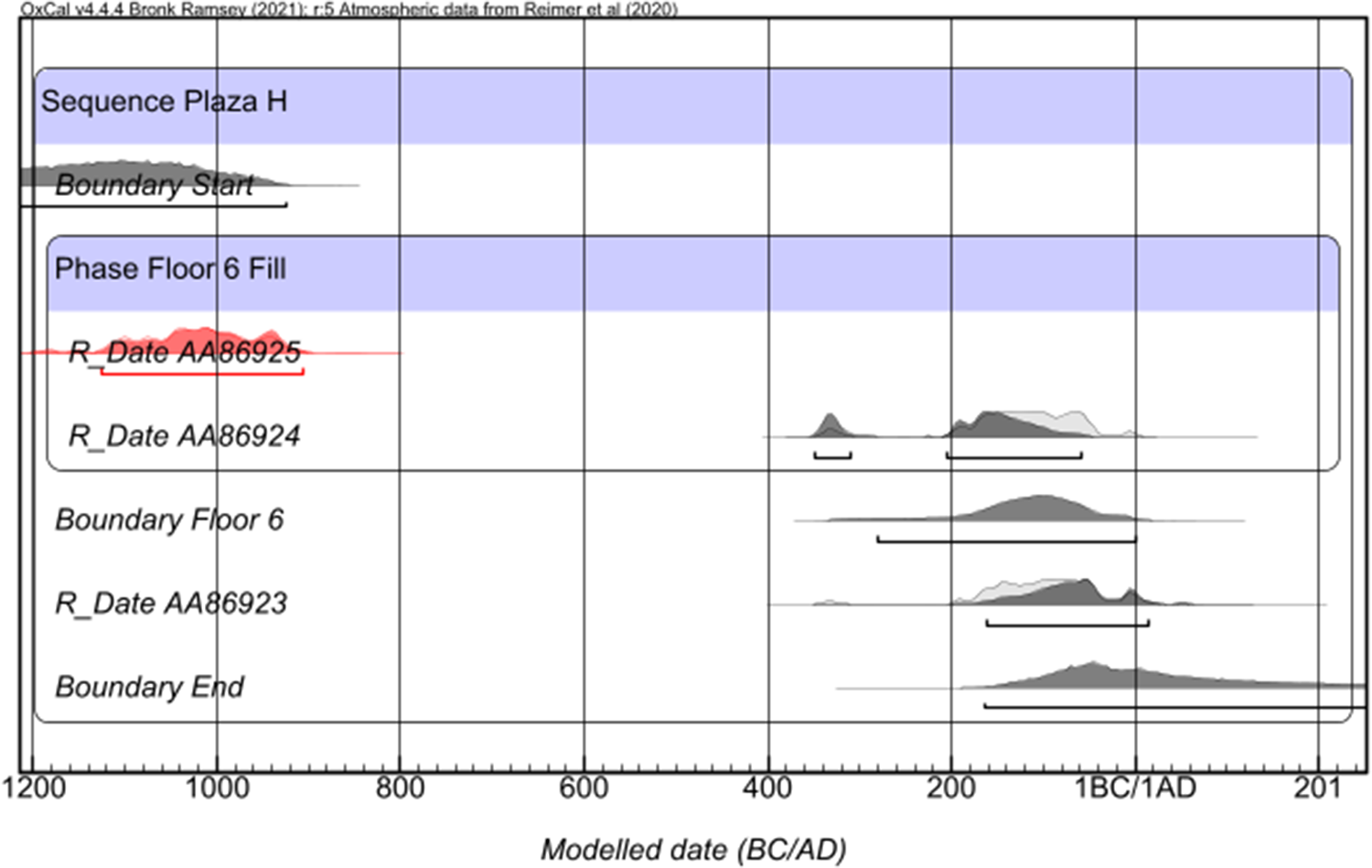
Figure 13 Long description
A graph showing the modeled dates for the construction phases of Plaza H's Floor 6. The x-axis is labeled 'Modeled date (BC/AD)' ranging from 1200 BC to 201 AD. The y-axis lists 'Sequence Plaza H', 'Boundary Start', 'Phase Floor 6 Fill', 'RDate AA86925', 'RDate AA86924', 'Boundary Floor 6', 'RDate AA86923' and 'Boundary End'. Each entry has associated radiocarbon data points represented by shaded areas, indicating probability distributions for the dates. The graph includes specific data points for RDate AA86925, AA86924 and AA86923, with boundaries marking the start and end of the construction phases.
The epigraphic and iconographic studies of Stela 20
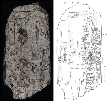
Inscriptions carved on Stela 20 support the continuity of the El Palmar kingship from the second to the fifth or sixth centuries a.d. (Figure 14). The stela, located near the center of Plaza E, measures 2.18 m x 1.04 m and is 0.42 m thick. In 1936 Thompson plotted and numbered the stela as Stela 20 on his map. However, he did not mention the presence of any inscriptions and iconographic images carved on the stela. As mentioned earlier, during the first field season in 2007, Tsukamoto and Esparza Olguín relocated the stela, but we did not observe any evidence of carving on the front face and lateral sides, either. When Campaña overturned the stela during fieldwork in 2018, however, we realized that the opposite face contained inscriptions and iconographic images, suggesting that Thompson did not overturn the stela. The front face, initially identified as the back face, had a ruler’s effigy surrounded by four frames with inscriptions carved into them. From the upper left to the lower right frames, we designated Columns pA to pF. The inscriptions previously carved on Column pA were entirely eroded. This column measures 50 cm x 14 cm and the size of well-preserved glyphs on the other columns ranges from 6 cm to 8.5 cm. Considering that a space between glyphs needs at least 1 cm, as the surviving glyphs in the other columns have, Column pA could contain five to seven glyphs. Because this frame is located in the stela’s left upper corner, we think that the eroded glyphs originally depicted dates such as Calendar Rounds. Unless the glyph size on this column was extremely small, there is no space for the Long Count. The event associated with the Calendar Rounds may have been a ruler’s biographical events, calendrical rituals such as casting drops/incense and stone binding, or warfare. Because the iconographic images represent a ritual scene, which we describe later, warfare is implausible. The name of an El Palmar ruler must also have been carved on this column due to its absence on the other preserved columns. Therefore, an ideal syntax in Column pA would have been: the tzolk’in date + the haab date + a possible glyph anchoring a specific time (e.g., tahnlam, haab, winikhaab) + verb (an event) + an El Palmar ruler’s name. After his name, it is possible to include part of a Distance Number, which continues on Column pB. We will discuss the Distance Number later.
Stela 20. Front face. Epigraphic drawing by Octavio Q. Esparza Olguín and Kenichiro Tsukamoto, and iconographic drawing by Daniel Salazar Lama © PAEP.
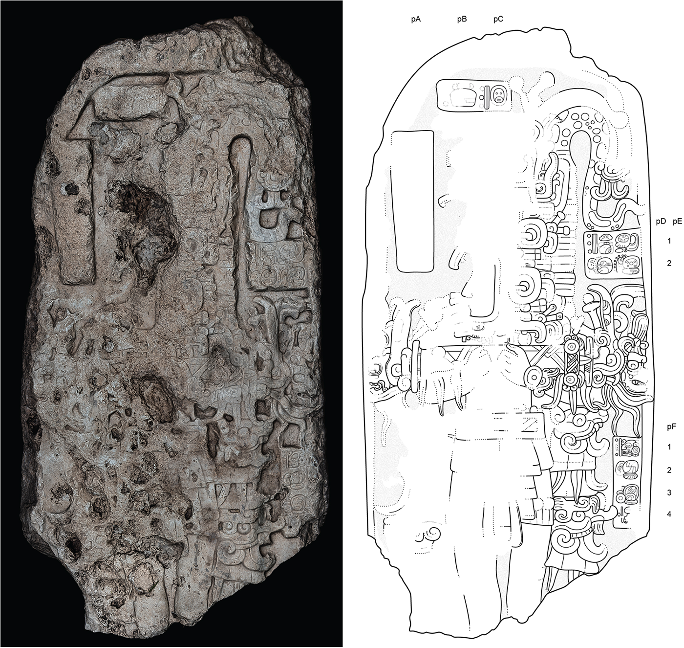
Figure 14 Long description
The image shows a stone stela on the left with intricate carvings, including figures and symbols. On the right is an epigraphic drawing of the same stela, detailing the inscriptions and iconographic images. The drawing is labeled with columns pA to pF, indicating different sections of the inscriptions. The stela features a ruler's effigy surrounded by frames containing glyphs, some of which are eroded. The drawing provides a clearer view of the carvings, highlighting the complexity and detail of the inscriptions.
The following glyphs in a row, located at the top of Stela 20, are also badly eroded (pB–pC). However, they provide clues to the stela’s erection date when examined alongside glyph D1 and iconographic images. Surviving part of glyph pB records a dot sign together with the partially preserved k’atun glyph, suggesting that it was originally the number 1, 2, or 3 k’atun. Since eroded Column pA should have had the first date with an event, probably related to the erection of the stela, glyph pB could have been part of the Distance Number articulated with the following Calendar Rounds 13 Ajaw 18 Yax (pC-pD1). There is no anchoring glyph that connects the Long Count, but the iconographic style helps delimit its temporal range. The stela depicts an El Palmar ruler carrying an intricate double-headed ceremonial bar adorned with lappets hanging from its ends. Flora S. Clancy (Reference Clancy1994:17–19) called this type of bar “the fancy ceremonial bar,” demarcating its temporal framework after a.d. 350–400. In fact, Stela 20’s ceremonial bar resembles that represented on Caracol Stela 20 (a.d. 400). Clancy also points out that the bar’s horizontal position appears only after the beginning of 9 bak’tun, ca. a.d. 445 (e.g., Uaxactun Stela 26). After a.d. 514 (9.4.0.0.0) the lappets are more often paired with rondels. The left side lappet of Stela 20 is badly eroded, but the right side is well preserved. Because rondels are missing on the right-side lappets, the potential date originally carved on Column pA ranges from 9.0.10.0.0 (a.d. 445) to 9.4.0.0.0 (a.d. 514). This date range is also consistent with the calligraphy of the glyphs, especially with the variant of the day Ajaw recorded in cartouche pC (Lacadena Reference Lacadena García-Gallo1995).
The next four glyphs carved on the right column provide unique information regarding the accession to office in the central Maya Lowlands during the fifth or sixth century. Glyphs pE1–pE2 record WA’-la-ja K’UH-IB?-bi-li, wa’hlaj k’uhul ibil? [winik], “The holy or divine bean field person is stood up.” Although the first glyph in the pE2 cartouche is eroded and does not reveal its internal elements, it is likely a variant of the logogram IB, given the evidence for the use of ibil as a title associated with the lords of El Palmar in other contexts which we will discuss later. On the other hand, the glyph in question bears some resemblance to the syllable ju, while we are unaware of any use of the title or name jubil associated with El Palmar rulers. The logogram WA’ (pE1) is a positional verb meaning “stand up, to be erected, set upright.” The verb is related above all to the action carried out by the god K’awiil within the cycle of the 819-day calendar (Bernal Reference Bernal Romero2014; Valencia Rivera Reference Valencia Rivera2022). The association of this verb with rulers has also been documented, as in the passage on the platform of Temple XXI at Palenque, where the ruler Upakal K’inich obtains a kind of title (Stuart Reference Stuart2005:38). In this context, we think wa’hlaj refers to investiture in the office of k’uhul ibil [winik]. What is k’uhul ibil winik? Regarding his decipherment of an IB logogram, Alexander Tokovinine (Reference Tokovinine2014:13–14) examined the title of k’uhul ibil winik, “divine bean field person” in other contexts. One of these is an earflare recovered from Tomb 4 in Structure 2 at Calakmul, which was probably the tomb of Yuknoom Yich’aak K’ahk’(Carrasco et al Reference Carrasco Vargas, Boucher, González, Blos, Vierna, Moreno and Vázquez Negrete1999). Carved glyphs depict k’uhul ib nal? [winik], likely an abbreviated spelling of k’uhul ibil winik (Tokovinine Reference Tokovinine2014:13). As we mentioned in the study of Stela 46, sakho’ok is one of the El Palmar royal dual titles. Thus, the earflares were probably a gift from an El Palmar ruler, mentioned in the inscription as Winikhaab Ajaw, to the Calakmul ruler, Yuknoom Yich’aak K’ahk’. Another example is Drawing 29 at Naj Tunich cave (Tokovinine [Reference Tokovinine2014:13–14]; see also Esparza Olguín and Tsukamoto [Reference Esparza Olguín, Tsukamoto and Esparza2022:62, Figure 2.10]). It depicts a ruler, Upakal K’inich, who carries the title of holy ibil person following the sakho’ok wakpiit ajaw titles. Due to the lack of additional information, Tokovinine (Reference Tokovinine2014:14) was unsure whether Ibil referred to an actual locale or some mythical first lime bean field associated with a particular royal dynasty. Nevertheless, he correctly predicted that the title belonged to rulers in southeastern Campeche because individuals represented on a set of stylistically uniform ceramic vessels bear the sakho’ok wakpiit ajaw titles, one of which was recovered from the site of Icaiche, located about 18 kilometers to the east of El Palmar (Cortés de Brasdefer Reference de Brasdefer, Fernando1996; Šprajc Reference Šprajc2008; Tokovinine Reference Tokovinine, Pillsbury, Doutriaux, Ishihara and Tokovinine2012). Elsewhere the first four authors of this article identified Upakal K’inich as one of the El Palmar rulers carved as the protagonist on Stelae 10 (a.d. 711) and 8 (a.d. 721) located at the Main Group and as an ancestor on the Guzmán Hieroglyphic stairway (Tsukamoto et al. Reference Tsukamoto, Olguín, Lama and Valenzuela2021:14–15). Unlike the Naj Tunich text mentioned earlier, none of these examples shows Upakal K’inich holds the title of k’uhul ibil. Instead, the text on Stela 8 records that Upakal K’inich is the sixth successor of yok’in, “sunset, sun foot, or the base of the sun,” and the fifth successor of the unknown title. Therefore, the title carved on Stela 20 is an additional example of the k’uhul ibil [winik] title, although the title is abbreviated like that carved on Yuknoom Yich’aak K’ahk’s earflare. Alternatively, the word ib means “armadillo” in Ch’ol and Tzeltal derived from Proto-Mayan *iib (Aulie and De Aulie Reference Aulie and De Aulie1978:58; Kaufman and Norman Reference Kaufman, Norman, Justeson and Campbell1985:120). If this is the case, the text means “The holy or divine armadillo is stood up.”
The last four glyphs carved on Column F support the long sequence of El Palmar kingship. Glyphs pF1–4 read 17- TZ’AK-bu-li SAK-o-ka 6-PIIT-AJAW, huklajuun tz’akbuul sak [ho’]ok? wak piit ajaw, “[he is] the 17th successor of White Valley, the lord of Six litters.” As we mentioned repeatedly, sakho’ok wak piit ajaw is El Palmar’s pair of royal titles. While the sakho’ok title appears to have occasionally been used for royal members, carvers, and ancestors, our available data suggest that only the living ruler appears to have been able to carry the wak piit ajaw title (Tsukamoto and Eaparza Olguín Reference Tsukamoto, Olguín, Okoshi, Chase, Nondédéo and Arnauld2021). A lack of ruler’s name on Columns pE–pF suggests that the same ruler carved on Column pA (but now completely eroded) ordered to erect Stela 20.
The question is in what year of 13 Ajaw and 18 Yax the El Palmar ruler was seated in the office of k’uhul ibil. As we mentioned earlier, Stela 20’s iconographic style spans a.d. 445–514. If the event originally carved on Column pA was a birth event, sihyaj, the event happened before the accession to k’uhul ibil and therefore the investiture ceremony was contemporaneous to the erection date. In this case, a possible Long Count associated with both the erection and investiture events is: 9.1.7.5.0 13 Ajaw 18 Yax (a.d. 462), 9.4.0.0.0 13 Ajaw 18 Yax (a.d. 514), or to be more conservative 9.6.12.13.0 13 Ajaw 18 Yax (a.d. 566). In contrast, if the event carved on Column pA was a ritual event such as casting drops/incense and stone binding, which was most likely a period-ending event celebrating the erection of Stela 20. If this is the case, the accession must be a retrospective event. The absence of the ruler’s name in the other columns indicates that the same ruler was responsible for both events, which therefore occurred during his lifetime. Based on the dynastic sequences of Palenque and Copán, the two most extensive sequences of kingdoms available in the Classic period, Martin (Reference Martin, Kerr and Kerr1997:853–854, Reference Martin2020:76) estimated the average length of Classic Maya reigns to be about 22.5 years. Furthermore, most Maya kings lived less than 100 years (Martin and Grube Reference Grube and Šprajc2008). Stela 20 was erected between a.d. 445–514 and the span between the erection event and accession event is at least 20 years due to the presence of the k’atun period (glyph pC1). The potential Long Counts associated with the accession event are: 8.16.1.15.0 13 Ajaw 18 Yax (a.d. 358), 8.18.14.10.0 13 Ajaw 18 Yax (a.d. 410), and 9.1.7.5.0 13 Ajaw 18 Yax (a.d. 462). The first Long Count (a.d. 358) is unrealistic, as 87 years must have passed since the earliest Long Count of the iconographic style (a.d. 445). Thus, the accession date happened between a.d. 410–462. Taking together both the accession and erection dates range from a.d. 410–566. We will discuss the possible accession date further regarding the inscriptions on Stela 46 later.
The archaeological context of Stela 20
Stela 20 is one of the four paired stelae and altars located on Plaza E. Although these stelae were found in a fallen state, their locations together with those of the altars suggest that the stelae originally faced the Architectural Complex PM3, which consists of four structures, including a royal house, forming an exclusive plaza, Plaza G. Five stratigraphic excavations were conducted at Plaza E: one in 2009 and the others in 2018. The results show that bedrock at the plaza surface was filled and leveled with a fine matrix that contained rich sascab (i.e., decomposed limestone) and small gravels before or during the Middle Classic period (a.d. 400–600). This could have been the earliest plaza floor, but no plaster remains were found. During the Middle Classic, this compacted surface was covered with a plaster floor and fill on which Altar 4 was placed. Altar 4 is paired with Stela 20 and the excavation yielded a cache associated with the altar. The cache consisted of three obsidian blades and marine shells, but no vessel was found. A radiocarbon assay recovered from the cache context dates to 252–407 cal a.d. (YU15688), but this date may reflect the old-wood effect if our interpretation regarding the range of the stela’s erection date (a.d. 462–566) is correct (Schiffer Reference Schiffer1986). After the Middle Classic period, Plaza E continued to be the arena of public gathering and subsequent El Palmar rulers commissioned to erect stelae and altars there. The latest stela we have documented in this plaza is Stela 14 which contains the Calendar Rounds that date to 10.0.10.0.0 6 Ajaw 8 Pop (January 23, a.d. 820).
El Palmar kingship and its regalia
The inscriptions carved on the early stone monuments record the long history of the El Palmar kingdom. The text on Stela 46 indicates that the El Palmar kingdom was already established with the dual royal titles, sakho’ok wak piit ajaw by a.d. 131, if not earlier. Applying Martin’s (Reference Martin, Kerr and Kerr1997) estimate (22.5 years) to El Palmar Stela 20’s possible erection date (a.d. 462–566) addresses how far the El Palmar royal sequence goes back. Stela 20 depicts that the protagonist was El Palmar’s seventeenth successive ruler. Since we do not know when the protagonist acceded to the throne as sakho’ok wakpiit ajaw (not k’uhuk ibil winik), we exclude the duration of his reign. The average span from him to the first ruler is then 360 years (22.5 years x 16 successors). The result shows that the accession date of the first ruler falls between a.d. 102–154, which accords well with the accession date of El Palmar ruler Ajaw K’al Ubaah on Stela 46 (a.d. 131). This result suggests that El Palmar ruler Ajaw K’al Ubaah was either the founder of the El Palmar kingdom or one of the earliest rulers close to the founder. These royal events, including Stela 46’s erection ritual, fall in the Terminal Preclassic period (75 b.c. to a.d. 250), a period of turmoil when several large polities collapsed (Estrada-Belli Reference Estrada-Belli2011; Hansen Reference Hansen, Traxler and Sharer2016) and royalty was transformed in the Maya Lowlands (Doyle Reference Doyle2017). The texts on Stelae 46 and 20 suggest that the El Palmar kingdom was established with the interlocking calendar systems during this time. El Palmar kingship continued until around a.d. 884, as the latest known monument, Stela 41, was erected at the K’awiil Plaza (Esparza Olguín and Tsukamoto Reference Esparza Olguín, Tsukamoto and Esparza2022; Thompson Reference Thompson1936a). This implies that El Palmar stelae contain the earliest Long Count date with a historical event in the Maya Lowlands and one of the longest dynastic histories recorded among Maya kingdoms. Due to the absence of stelae between a.d. 820–884, however, it is possible that the El Palmar kingdom experienced a rupture. In fact, the latest monument that records the royal title of sakho’ok is not Stela 41 but Stela 14 that was erected in a.d. 820.
The iconographic elements of the stelae attest to the continuity of El Palmar regalia over centuries. Stela 46 (a.d. 180) represents the king Ajaw K’al Ubaah who carries a disembodied head of the Jaguar God of the Underworld as the tutelary god of the royal lineage. On Stela 45 (a.d. 342), the king Tz’u Chak Ahk carries a ceremonial bar from which two deities emerge; the right end head may represent the conflation of the Jaguar Paddler God and JGU while the left end shows the solar deity K’inich Ajaw, the nocturnal/diurnal duality of the sun. As with Stela 45, Stela 20 (a.d. 462–566) represents a double-headed ceremonial bar with serpent heads at the ends. From the right serpent mouth, a JGU head emerges, while the same solar deity K’inich Ajaw comes out from the other end. The JGU on Stela 20 is characterized by gathered hair, a scrolled eyebrow, a spiral eye, a facial twisted element known as a “cruller” around the eye, and a fang (Schele and Miller Reference Schele and Miller1986; Taube and Houston Reference Taube, Houston, Houston, Newman, Román and Garrison2015). Moreover, El Palmar Stela 8 erected on the Great Plaza in a.d. 721 depicts the king Upakal K’inich who impersonates JGU by wearing its mask (Tsukamoto et al. Reference Tsukamoto, Olguín, Lama and Valenzuela2021:10–11). Thus, the presence of JGU on these stelae shows the continuity of El Palmar regalia over 500 years.
Early kingship in the central Maya Lowlands
Several early kingdoms were established in the central Maya Lowlands during the Terminal Preclassic and Early Classic periods (75 b.c. to a.d. 400) (Stuart Reference Stuart2024:2–9). This area, including southeastern Campeche, could have been the focal point of early Maya kingship with the interlocked calendrical systems, as evidenced by the concentration of carved monuments bearing early dates. In southeastern Campeche, the earliest example of the establishment of kingship comes from the site of Chakjobon, where a set of mural paintings with early hieroglyphic texts dated to the Late Preclassic period, similar to those from San Bartolo and Kaminaljuyú (Grube Reference Grube2023). These glyphs are associated with the figure of a ruler seated on his throne as a representation of royal power (Grube Reference Grube2023:18). On the other hand, monuments at the sites of Candzibaantún, Balakbal, and Champerico record early royal events (Grube Reference Grube and Šprajc2008). Candzibaantún is a secondary center located about 47 kilometers southwest of El Palmar. The main structure (Structure 1) and two small structures form an atypical triadic complex and plaza where three stelae (Stelae 2–4) were found standing (Šprajc Reference Šprajc2008:77). Another stela (Stela 1) was found standing atop Structure 1. Nikolai Grube (Reference Grube and Šprajc2008:185–186) documented these four standing stelae (Stelae 1–4) that were erected during the Early Classic period, although they were heavily eroded. Inscriptions of Stelae 2 and 3 contain identifiable Long Counts that date to 8.18.0.0.0 (a.d. 396). Stelae 1 and 4 might have also had the same year although they are too eroded to identify with confidence. If they were erected in the same year, it is most likely that the same king ordered the erection of these stelae. Unfortunately, the stelae are too eroded to assess accurately. At Balakbal, located about 34 kilometers southwest of El Palmar, five stelae and an altar have been reported, but only the inscriptions of Stela 5 are preserved (Ruppert and Denison Reference Ruppert and Denison1943; Šprajc Reference Šprajc2008). Following the reading of Grube (Reference Grube and Šprajc2008:183), Stela 5 was erected in 8.18.10.0.0 (a.d. 406) to commemorate the death and burial of a local ruler who had died 31 days earlier (8.18.9.17.18), just 29 days before the first k’atun of his reign was completed. This king acceded to the throne on 8.17.9.17.18 11 (a.d. 386), 44 years after the accession of El Palmar king Tz’u Chak Ahk. Finally, Champerico, located about 25 kilometers southwest of El Palmar, consists of several plazas, pyramidal temples, residential structures, a ballcourt, and three stelae (Šprajc Reference Šprajc2008:34–37). Stela 3, erected on 9.8.10.0.0 (a.d. 603), has a retrospective date, 8.16.10.0.0 (a.d. 366) which is associated with the hieroglyphic text in Ap8: 12-TZ’AK-li-AJAW, the twelfth king in the sequence, a similar expression found in El Palmar Stela 20. These examples demonstrate the establishment of early kingdoms with the calendar systems in the central karstic upland and the El Palmar kingdom predated them. Further research in this area will provide additional insights into the relationship between emergent Maya kingship and the Calendar systems.
The emergence of kingship at El Palmar
Why did the El Palmar kingdom establish in the second century a.d.? Maya archaeological and epigraphic studies have demonstrated that significant transformations occurred in the central karstic upland during the Terminal Preclassic period, about a.d. 1–250. The emergence of kingship in the central Maya Lowlands already occurred at San Bartolo and in the Mirador Basin during the Late Preclassic period (Hansen Reference Hansen, Traxler and Sharer2016; Reese-Taylor and Walker Reference Reese-Taylor, Walker, Masson and Freidel2002; Saturno et al. Reference Saturno, Beltrán, Rossi, Friedel, Chase, Dowd and Murdock2020; Stuart et al. Reference Stuart, Hurst, Beltrán and Saturno2022), but they did not last long. Large Preclassic polities with massive monumental architecture became unstable and were abandoned during this period. El Mirador, one of the largest Late Preclassic polities, experienced a decline and eventual abandonment by a.d. 150 (Hansen Reference Hansen, Traxler and Sharer2016:412; Houston and Inomata Reference Houston and Takeshi2009). Other large polities of the Mirador Basin also collapsed (Estrada-Belli Reference Estrada-Belli2011; Hansen Reference Hansen2004). In southeastern Campeche, the site of Yaxnohcah was abandoned around this time (Walker et al. Reference Walker, Reese-Taylor, Mathews, Laporte, Arroyo and Mejía2006). Paleoenvironmental studies suggest that environmental changes occurred resulting from droughts, soil erosion, and deforestation (Ebert et al. Reference Ebert, May, Culleton, Awe and Kennett2017; Kennett et al. Reference Kennett, Breitenbach, Aquino, Asmerom, Awe, Baldini, Bartlein, Culleton, Ebert, Jazwa, Macri, Marwan, Polyak, Prufer, Ridley, Sodemann, Winterhalder and Haug2012; Wahl et al. Reference Wahl, Byrne, Schreiner and Hansen2006). However, the relationship between the collapse of the political system and environmental changes needs further investigation. Unlike the Terminal Classic period (a.d. 800–950), when the collapse of kingship was a regional phenomenon, the decline of El Mirador, Nakbe, and Yaxnohcah during the Terminal Preclassic period could have provided opportunities for the emergence of new royalty. The sites such as Tikal, Rio Azul, Nakum, and Holmul experienced continuous growth, marked by significant construction projects and rich burials, during the transition from the Late Preclassic to the Early Classic period (Callaghan et al. Reference Callaghan, Estrada-Belli, de Estrada and Aimers2013; Estrada-Belli Reference Estrada-Belli2011; Inomata et al. Reference Inomata, Triadan, Román, Ruiz, de León and Cuerva2010; Laporte Fialko 1995; Źrałka et al. Reference Źrałka, Hermes and Koszkul2018). El Palmar appears to have been another example of seizing the opportunity to establish a kingship. We suggest that the accession of Ajaw K’al Ubaah in a.d. 131 and the erection of Stela 46 in a.d. 180 are part of this regional phenomenon. At El Palmar the kingship could have been consolidated by means of the Long Count and the tzolk’in calendar during the Terminal Preclassic period. The erection of carved monuments with the interlocking calendrical systems and theatrical performances enacted by successive kings on public plazas became a defining mechanism of the El Palmar regime during the Terminal Preclassic period. The continuous erection of carved monuments and the new construction projects of the two largest public plazas, the Great Plaza and Plaza E, during the following periods attest to the success of theatrical performance (Tsukamoto Reference Tsukamoto, Tsukamoto and Inomata2014, Reference Tsukamoto and García2025).
Conclusion
The application of high-resolution 3D modeling enables us to re-examine barely visible inscriptions and iconographic images on carved monuments that scholars previously paid little attention to. The three-dimensional documentation also digitally preserves cultural patrimony and makes it available to other scholars for future research. In fact, our readings of the inscriptions on Stelae 20, 45, and 46 are partly provisional, and future technological advances could resolve the uncertainties.
The presence of carved monuments in the central karstic upland demonstrates that the emergence of kingship in the central Maya Lowlands during the Late Terminal Preclassic period was a regional phenomenon. Unlike its absence on other early inscriptions such as El Mirador and San Bartolo, El Palmar Stela 46 and subsequent monuments suggest that the Long Count played a vital role in the continuity of kingship during the Classic period. Further study of this region will provide new insights into the emergence of Maya kingship.
Acknowledgements
We thank the Kiché Las Pailas people for their field and laboratory assistance. Our gratitude is also extended to David Mora Marin and two anonymous reviewers who provided insightful comments on the early version of this article. We acknowledge the project members, especially Araceli Vázquez, Xanti Ceballos, Hirokazu Kotegawa, Raquel Barroso, and Uriel Camacho who collected data regarding this study. The Consejo de Arqueología of the Instituto Nacional de Antropología e Historia (INAH) has generously granted permission to the El Palmar Archaeological Project (PAEP) for fieldwork and laboratory analyses. We thank the University of California, Riverside, the Research Institute for the Dynamics of Civilization of Okayama University, Centro de Estudios Mayas of the Universidad Nacional Autónoma de México, the Escuela Nacional de Antropología e Historia, and the Centro INAH Campeche for institutional support.
Funding statement
This research was funded by Japan Society for the Promotion of Science KAKENHI (24H02192, 25H00491, 25H01936), and the PAPIIT Project IN403823 (DGAPA-UNAM) supported epigraphic studies.

 Open access

