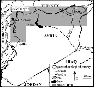
The project aims to take up previously recognised indications of Bronze and Early Iron Age environmental and economic change in northern Syria and southern Turkey and specify these developments through new carpological, anthracological and geoarchaeological studies (e.g. Riehl 2003). At present, our study has concentrated mainly on the Upper Khabur area of NE Syria, where a geoarchaeological study has been undertaken, and carpological and charcoal remains have been identified from Tell Mozan, from where some results will be detailed below. However, research is also under way on archaeobotanical samples retrieved from Bronze and Iron Age levels at Emar, Tell Atchana, Kinet Höyük and Qatna (Figure 1).
Map of the project area.

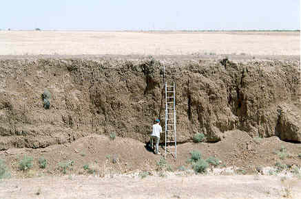
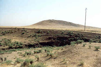
About eighty fluvial sequences have been investigated, recorded and sampled along several small streams of the Upper Khabur Watershed (Wadi Khanzir, Avedji, Jaghjagh, Jarrah and Kuneizir) (Figure 1). In total about 510 sediment samples have been retrieved and most have been analysed. A preliminary fluvial chronology has been established through the use of a simple thermoluminescence screening on sherds (Deckers et al. 2005, Deckers in prep.). Several Optically Stimulated Luminescence (OSL) and radiocarbon samples have been submitted, and the results are expected in due course. However, the present data suggests already that the north-east Syrian landscape has changed considerably during the Holocene and that thick and extensive deposits mostly consisting of fine grained alluvial material cover parts of the plain (Figure 2) which has implications for archaeological survey in the area. Many tell sites are buried within this landscape, and e.g. Chalcolithic occupation levels which have been found at a depth of 3m under the present day plain demonstrate that a survey surface collection of sherds may not represent all occupation stages of the tell (Figure 3). Furthermore, the evidence of an aggraded plain implies the occurrence of many floods. Further chronological refining and environmental research will establish whether the main period of tell building in the area, more precisely the Early Bronze Age, correlates with a more latent threat for flooding than for example the Iron Age when people seem to have settled lower down (Wilkinson & Barbanes 2000).
An example of thick and extensive Holocene fluvial sediments along the Wadi Jarrah.

An example of a tell buried by fluvial sediments: Tell Farsouk Kebir along the Wadi Jarrah.

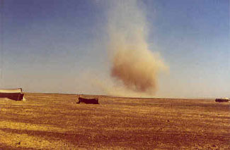
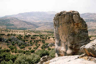
The anthracological remains from Tell Mozan also testify to considerable landscape changes. At present, about 6350 charcoal fragments have been identified from the site deriving from 74 samples. In most of the samples a lot of fragments from deciduous oak have been identified. At present the landscape is treeless as far as one can see (Figure 4). Only about 150km north, up in the mountains of Turkey, oak parkland vegetation can be found which probably resembles the Bronze Age vegetation of the Tell Mozan region (Figure 5). This vegetation picture of the Tell Mozan surroundings fits very well with the archaeozoological remains, indicating a large presence of boar amongst the game (pers. comm. with Uerpmann). Apart from large quantities of deciduous oak, some other taxa have been identified from the Tell Mozan settlement area (in decreasing number of fragments): Populus (poplar)/Salix (willow), Olea (olive) (only in 2 samples though), Fraxinus (ash), Rosaceae, Ulmus (elm), Platanus (planetree), Pistacia, Juniperus, Cedrus, Vitis (vine), Tamarix and Cupressus. From the palace area a much larger quantity of Pinus (pine) fragments have been identified, which were probably imported. One of the project's aims is to solve the question when this landscape became so depleted as it appears today, as ancient letters indicate that the Assyrians literally felled thousands of logs on a regular basis and floated them down the Tigris to the Assyrian hearland (Reference ParkerParker 2003: 107).
The present day treeless landscape of the Upper Khabur Watershed.

Present day oak parkland vegetation in southern Turkey, probably resembling the Bronze Age vegetation of the Tell Mozan surroundings.

However, agricultural practices and intensive settlement by the Tell Mozan people might also have reduced the trees in the landscape. More than 10 000 carpological remains from the mainly Middle Bronze Age cultural layers of Tell Mozan have been identified so far. Agricultural production was concentrated on two-row barley (Hordeum distichum), followed by emmer wheat (Triticum dicoccum). Bread wheat (Triticum aestivum/durum) also made up a large proportion of the diet, indicating relatively favourable conditions by its comparatively higher water requirement, which was probably easily met as modern annual precipitation in the Mozan area is far above the limit of rainfed agriculture. Amongst the pulses, bitter vetch (Vicia ervilia), grass pea (Lathyrus sativus/cicera) and lentil (Lens culinaris) are almost equally represented in small numbers, while also chick pea (Cicer arietinum), and bean (Vicia faba) are present (Reference RiehlRiehl 2000 and new unpublished results). Beside some grape pips (Vitis vinifera) also fig (Ficus carica) is present with very few seeds. As their presence is in agreement with the natural distribution of their wild ancestors both species were probably local products as there is also suggested by the charcoal find of vitis (see above). In relation to the question of prehistoric hydrological condition and their consequences on plant production, it is interesting to note that fig and grape remains appear in larger amounts at the Euphrates site of Emar, i.e. outside their range of natural distribution (Reference RiehlRiehl 2001). It remains to be seen whether the conditions allowed cultivation of these crops there or if they were imported.
One step in this direction is the study of stable isotopes in cereal grains from the sites, which will help to address the question of hydrological conditions during the periods under consideration.
Acknowledgements
Deckers' research was possible thanks to a DFG (German Research Council)-fellowship in the 'Graduiertenkolleg: Anatolien und seine Nachbarn' (2002-2004) and a research position (2004-2005) thanks to a generous grant from the 'Strukturfonds' from the University of Tübingen which also supports the project as a whole under the direction of Simone Riehl.
Simone Riehl would like to thank the MWK (Ministry of Science, Research and the Arts of the State of Baden-Württemberg, Germany), the DFG and the University of Tübingen for financial support, as well as the excavators of the sites mentioned for technical and financial support.