Introduction
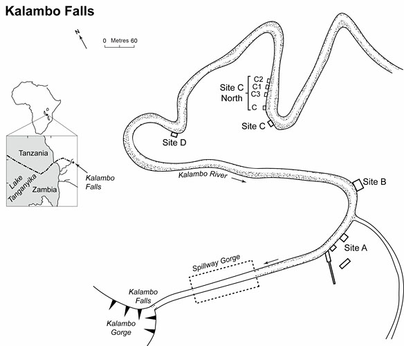
Location map of Kalambo Falls showing the spillway gorge, excavation areas A, B, C and D, and trenches (Units) in Site C North (2006) based on Reference ClarkClark 1969 (Figure 1.2). (The changed course of the river since the 1960s is not shown.).

For an older generation of archaeologists, the site of Kalambo Falls (Zambia) needs little introduction as one of the key Palaeolithic sequences of Africa. Discovered in 1953, extensive, well-published excavations were undertaken between 1956 and 1966, led by the late J. Desmond Clark (Reference ClarkClark 1969, 1974, 2001). The resulting archaeological sequence spanned the late Acheulean to late Iron Age. The site is best known for waterlogged Acheulean 'living floors' that preserved charred wood, seeds and wooden tools. Subsequent research into the formation processes operating at Kalambo (Sheppard & Kleindienst 1996; Schick 2001) led to a substantial revision of the site's archaeological significance. Fluvial processes apparently created much of the spatial patterning seen in the Acheulean horizons and may even have shaped some of the supposed wooden tools (Reference ClarkClark 2001: 24). The lack of a reliable radiometric chronology for Kalambo's Palaeolithic sequence has also contributed to the site's marginalisation in current discussions about the timing and importance of the technological transition from hand-held (Mode 2/ Acheulean) to hafted tools (Mode 3/ Middle Stone Age) (Reference McBreartyMcBrearty 2001). Despite these limitations, Kalambo remains valuable as one of the few sites in Africa containing a stratified - though discontinuous - sequence of Mode 2 and Mode 3 horizons (Barham & Mitchell 2008), with numerically large artefact samples providing important information about technological variability before and after the Mode 2/3 transition.
In August 2006, a week-long investigation was undertaken at Kalambo to assess the potential for further excavation to resolve issues of age, ecological context and formation history. Small-scale excavations located sediments containing Mode 2 and early Mode 3 horizons which were sampled for luminescence dating and palaeoenvironmental analyses. A geomorphological survey was made of the Kalambo River basin to improve understanding of the site's formation by fluvial processes. This is an interim report on the stratigraphic succession and its archaeological content. Other ongoing analyses in this interdisciplinary project will be published later.
Unit C step trench with measurement underway of sediment gamma dose rates for luminesence dating of a Mode 3 horizon. The lowest step trench contains a Mode 2 horizon at river level. Units C3, C2 and C1 are visible downstream.

The Kalambo Formation and Site C North
Clark's excavations took place at the western end of the Kalambo basin, upstream of a narrow spillway gorge leading to the falls (Sites A, B, C, D; Figures 1-2). Intermittent blocking of the spillway, at undated intervals, may have controlled the deposition of fluvial and colluvial sediments that comprise the Kalambo Formation, which consists of a succession of three members: Mkamba, Mbwilo and Chiungu (Kleindienst 1969). The 2006 excavations targeted the two lower members. Mkamba is associated with waterlogged Mode 2 and early Mode 3 (Sangoan Industry) horizons; the overlying Mbwilo member's basal sands contain pebble lines or aggregates with Mode 3 artefacts (Lupemban Industry).
Surviving excavation trenches in Sites A, B and D were too overgrown or collapsed to justify clearance in the time available. No trenches survived in Site C, but this locality afforded easy access and an exposed concentration of Mode 3 artefacts eroding from sands of the Mbwilo member (~2.3m above the river) (Figure 3). Handaxes and cleavers from the Mkamba member lay just beneath the river's surface and on the river bank. The area chosen for investigation in 2006 was called Site C North (S8° 35' 32.23", E31° 14' 37.01") because of its location downstream and north of the original site (Figure 1). The river here had changed course since the 1960s, providing new exposures for investigation.
Artefact concentration (Unit C) containing Mode 3 (Middle Stone Age) artefacts.

Four step trench units were excavated along a 52m stretch of the river bank and labelled C, Cl, C2 and C3 (Figure 1). Quartz sand samples for dating were collected from sediments bracketing archaeological horizons in each Unit and in situ dosimetry recorded. Unit C targeted the exposed Mode 3 concentration and underlying sediments to a depth of 4m. The resulting sequence contained two Mode 3 horizons, both with core-axes and blades attributable to the Lupemban, and a basal Mode 2 horizon below river level with fresh bifaces and flake tools (Figure 4). Unit C3 was excavated as a geomorphological section to sample (for dating) a large channel cut-and-fill feature. Units C1 and C2, sited further downstream, sampled the most significant stratigraphic feature of the excavations: a horizontal clay layer, located ~1m above the river varying in thickness between 0.15-0.43m (Figure 5). Root casts and a possible large animal footprint (hippopotamus?) on its surface suggest the clay was deposited by fluvial processes in a wetland setting. Artefacts found on and overlying the clay are Mode 3, but the sample is currently too small to distinguish between Lupemban or Sangoan affinities. Mode 2 bifaces are embedded within and below the clay and occur to river level where the excavation stopped.
Quartzite cleaver (Mode 2) in fresh condition from basal Unit C at river level.

Unit C2 section of clay horizon containing Mode 2 artefacts (pollen samples in blue tubes). Luminescence samples were collected from the underlying and overlying sands to give an age bracket for the horizon.

The clay horizon offers the closest stratigraphic proximity of Modes 2 and 3 yet recorded at Kalambo Falls; the dating of the sands that bracket the clay is a current priority in the ongoing programme of analysis. Further excavations will focus on expanding the artefact sample above and below the clay to characterise in detail the technological continuities and differences across this sedimentological divide.
Kalambo Falls may soon regain its place among the preeminent Palaeolithic sites of Africa.
Acknowledgements
We are grateful to the National Heritage Conservation Commission and to staff at the Moto Moto Museum (Mbala) for their invaluable assistance in the field. Support for the project came from the Arts and Humanities Research Council and the Natural Environment Research Council (EFCHED).