Although aerial archaeology in Poland dates back to the 1930s, it has never gained full recognition from the majority of Polish archaeologists. A belief still prevails that the method is not fully applicable in Polish soil conditions because cropmarks become visible only for specific archaeological features and on the most favourable soils (cf. Wessex in England). Hence, it is not surprising that aerial surveys are carried out on an irregular basis by a limited number of scientists who share their experiences in hope of propagating the method in Poland (cf. Reference BarfordBarford 1998; Reference KobylinskiKobylinski 1999; Reference RaczkowskiRaczkowski 2002). Yet, every now and then spectacular discoveries are made which demonstrate that aerial survey can be a useful tool for Polish archaeology (cf. Nowakowski & Raczkowski 2000).
One such example is the research on Neolithic settlements of the Brzesc Kujawski type. For many years the Brzesc Kujawski type settlements (the Lengyel culture = the Late Band Pottery culture - Reference CzerniakCzerniak 1980) have been receiving attention from archaeologists studying the Neolithic in Central Europe from different theoretical viewpoints. The settlements constitute the basis on which interpretations of economic systems are made and the organisation of settlement systems is discussed (e.g. Czerniak & Piontek 1979; Reference BoguckiBogucki 1982; Reference GrygielGrygiel 1986). The role they played in the formation of megalithism is also widely studied (e.g. Reference SherrattSherratt 1990; Reference BradleyBradley 1998) and so are the symbolic relations between the house and the megalithic grave within the context of social transformations and the development of belief systems (e.g. Reference HodderHodder 1990).
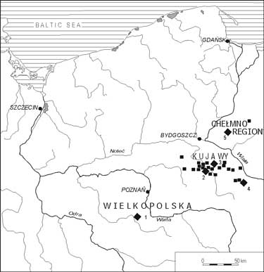
Late Band Pottery culture in the Polish Lowlands. Sites with longhouses: 1 - Racot, 2 - Krusza Zamkowa, 3 - Radojewice, 4 - Brzesc Kujawski, 5 - Zelgno (according to Reference CzerniakCzerniak 2002)

The Brzesc Kujawski type settlement is a characteristic, spatially extensive (2-6ha) group of many longhouses and repeated through many centuries, which consists of several trapezoidal longhouses (Reference JazdzewskiJazdzewski 1938; Gabalówna 1966; Reference CzerniakCzerniak 1980; 1994; 2002; Reference BoguckiBogucki 1982; 1988; Grygiel & Bogucki 1997). They appeared in the period between 4500 and 3800 BC, mainly in the Polish Lowlands (Figure 1), and specifically in the regions of Kujawy and Wielkopolska which offered the most favourable farming conditions. Brzesc Kujawski is the best known site (Reference JazdzewskiJazdzewski 1938; Reference GrygielGrygiel 1986), but similar extensive and long-lived settlements are known from Krusza Zamkowa, Biskupin, Koscielec Kujawski, Zegotki, Kuczkowo, Oslonki (Kujawy) and Racot (Wielkopolska) (for a list of settlements, see Reference CzerniakCzerniak 2002).
The distribution of settlements on maps does not reflect their real distribution. These Neolithic settlements are not easily detectable by means of traditional archaeological methods even though many are known. Fieldwalking survey is the traditionally preferred method for detecting archaeological sites in Poland. It is generally quite effective in the regions under consideration where most of land is under cultivation and the mainly light soils enable the plough to reach archaeological strata. However, the case of longhouses is exceptional. The settlements produce sparse amounts of pottery which is very fragile and becomes quickly destroyed on the surface of the soil. Moreover, the material cannot be easily differentiated from pottery from other periods (in contrary to the pottery of the early Neolithic Linear Band Pottery culture which is very durable and easily identifiable; hence, a large number of settlements of the Linear Band Pottery culture has been recorded).
There is a widespread belief that this type of settlement cannot be detected by means of other methods such as aerial photography, resistivity or magnetic survey) due to unfavourable conditions in the Polish Lowlands (heterogeneous subsoil consisting of clays and sands with multiple natural pits) and the specificity of archaeological features (rather shallow, the filling not easily distinguishable from the bedrock). This is why the majority of longhouses known today have been discovered accidentally while studying sites from other periods or supervising construction work.
In this paper we would like to explore the possibility of recording longhouses in Poland by means of aerial photography. We believe that the photographs of two Brzesc Kujawski type settlements discussed below demonstrate the huge potential of the method in this respect.
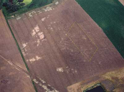
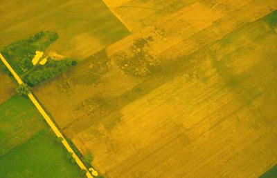
Zelgno, comm. Chelmza, site 12. Aerial photograph of the settlement. Foundation trenches of longhouses are visible as slightly lighter lines.The yellow dashed line indicates the approximate location and size of the archaeological trench (see FIGURE 3, 4). Photo: W. Sosnowski, July 14, 2000.

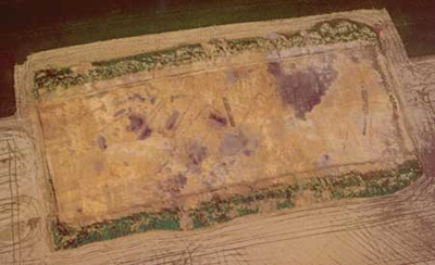
Zelgno, comm. Chelmza, site 12. Aerial photograph of the excavations with visible trapezoidal longhouses. Photo: W. Sosnowski, April 30, 2001.

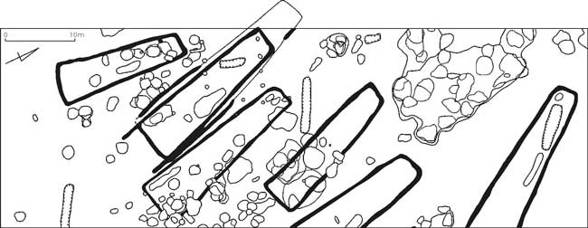
In 2000 two short aerial surveys were carried out independently of one another, one in the Chelmno region (W. Sosnowski) and one in Kujawy (W. Raczkowski). Sosnowski did his research in the Chelmno region (north-east of Kujawy) in June 2000. He photographed a Linearbandkeramik culture settlement previously known from fieldwalking survey and keyhole excavation (Zelgno, comm. Chelmza, site 12). It had been established from these studies that the early Neolithic strata were significantly destroyed. Analysis of an aerial photograph indicated the existence of longhouses of the Lengyel culture. The discovery resulted in an additional aerial survey (July 2000) which confirmed the presence of a Brzesc Kujawski type settlement (Figure 2). Following the reconnaissance, excavations commenced in September 2000 and continued in 2001 (Figure 3 and 4, cf. Reference CzerniakCzerniak 2002).
Zelgno, comm. Chelmza, site 12. Excavated area showing the layout of Late Band Pottery culture trapezoidal longhouses (black) against other archaeological features (according to Reference CzerniakCzerniak 2002).

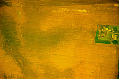
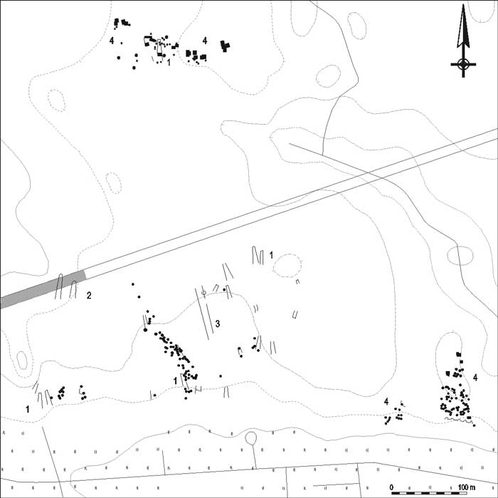
In July 2000 Raczkowski undertook a short one-hour survey along the Yamal gas pipeline in Kujawy. During earlier rescue excavations carried out in advance of the construction of the gas pipe, fragments of two longhouses of the Late Band Pottery culture were discovered in Radojewice (comm. Dabrowa Biskupia, site 29). Aerial photographs taken over the site (Figure 5 and 6) helped ascertain that these longhouses were fragments of an extensive Brzesc Kujawski type settlement (Figure 7).
Radojewice, comm. Dabrowa Biskupia, site 29. Aerial photograph of the north part of the settlement (see Figure 7). Photo: W. Raczkowski, July 8, 2000.

Radojewice, comm. Dabrowa Biskupia, site 29. Aerial photograph of the central part of the settlement (see Figure 7). Photo: W. Raczkowski, July 8, 2000.

Radojewice, comm. Dabrowa Biskupia, site 29. A map showing transcribed archaeological features against main topographical features. Key: 1 - trapezoidal longhouses; 2 - area excavated on the Yamal gas pipeline where remains of two longhouses were discovered; 3 - cursus (?); 4 - pits.

Summing up, during one season of limited flying valuable aerial data were acquired on two Brzesc Kujawski type settlements and several myths were debunked concerning the Early Neolithic in the Polish Lowlands and the applicability of aerial photography in Poland.
1. The discovery of the Zelgno settlement disproved the belief that the Brzesc Kujawski type settlements do not occur in the Chelmno region. It had been assumed that these settlements were located only within regions with a long history of intensive early farming settlement which was thought to be limited to Kujawy in the Polish Lowlands.
2. The limited spatial range of many excavations in which separate longhouses were discovered could lead to the belief that many settlements of that period were isolated households. However, the case of the Radojewice settlement shows that the presence of one or two houses, even if to some extent spatially separated, need not to be interpreted as an individual household. In any one case it necessitates further studies to check whether it is part of a larger settlement.
3. Aerial photographs help reveal new features (cf. parallel lines in the central part of the Radojewice settlement - Figure 6 and 7), which have not been yet discovered on Polish sites. On other sites (mainly in the UK) such features are defined as cursuses.
4. The soil conditions at the two settlement sites show that the types of the soil (sands, clays, black soils) do not hinder the development of cropmarks. Moreover, even features in Zelgno (cf. Figure 3), which were poorly legible during the excavations, became visible through cropmarks.
5. The main factors that affect the development of crop marks are well known from countries such as Britain, Germany, France, the Czech Republic and Hungary (Reference WilsonWilson 2000). The air surveys carried out in 2000 proved that these are equally active in the Polish Lowlands where cropmarks were recorded in wheat, barley and rye. The research profited from the drought which affected the regions and lasted from, approximately, 20 April until 20 June 2000.
The experience gained from the excavations works at Zelgno and from the analysis of the aerial photographs of the Radojewice settlement raises new questions. An understanding of the factors affecting the development of cropmarks is essential if we are to advance uses of aerial survey for Polish archaeology. It has been assumed for quite a long time that such an important factor is the potential soil moisture deficit (Evans & Jones 1977; Riley 1979). However, in the case of the Radojewice settlement it does not account for why only parts of houses (their foundation trenches) were revealed as cropmarks. A research study of other variables (local soils, different depth or fills of features etc.) that affect the Radojewice case is already being planned.
Aerial photographs offer new prospects for the study of the Brzesc Kujawski type settlements. Aerial survey provides a means of recording the settlements, recognizing their spatial distribution and putting them into environmental and cultural context. Structures such as longhouses are relatively easy to identify on air photographs as archaeological sites. More problematical for Polish photo interpreters is the correct identification of archaeological features that were pits of some form or other (pit-houses, storage pits, rubbish pits, graves, post holes etc.). It is difficult to distinguish them from natural pits and to establish their chronology. Trapezoidal longhouses of the Lengyel culture are so typical that they are easily identifiable and datable. We hope that the ability to easily identify such sites from the air and on aerial photographs will strengthen acceptance of this method of survey among Polish archaeologists.
Acknowledgements
Grzegorz Skommer and Rog Palmer deserves our express gratitude for all their effort to make the text more English than Polish English. Special thanks also go to Krzysztof Maciejewski for his work with some figures.