

In 1944 Edmund Schulman published the first dendrochronology study for Mexico in which he found that some trees, such as Douglas fir (Pseudotsuga menziesii) and some pine species (Pinus spp.), had the potential to be used as chronological timekeepers and to help understand past climate conditions, and that dendrochronological analysis on these samples would therefore be a useful tool for archaeologists (Schulman Reference Schulman1944). Scott (Reference Scott1966) reviewed all evidence then available and argued for the potential of dendrochronology in Mexico, including its archaeological sites. Although work was slow to start, much has been achieved with the development of long tree-ring sequences from living and relic trees in Mexico and nearby areas covering the past 1,300 years (Stahle et al. Reference Stahle, Diaz, Burnette, Paredes, Heim, Fye, Soto, Therrell, Cleaveland and Stahle2011; Stahle et al. Reference Stahle, Burnette, Villanueva, Cerano, Fye, Daniel Griffin, Cleaveland, Stahle, Edmondson and Wolff2012; Villanueva Díaz et al. Reference Villanueva Díaz, Paredes, Stahle, Luckman and Therrell2002). Archaeological applications have been less successful. With the noted exception of the Casas Grandes region in Chihuahua, Mexico (Bannister and Scott Reference Bannister and Scott1962; Scott Reference Scott1966), and one other very recent exception focused on Maya chronology (Kennett et al. Reference Kennett, Hajdas, Culleton, Belmecheri, Martin, Neff, Awe, Graham, Freeman, Newsom, Lentz, Anselmett, Robinson, Marwan, Southon, Hodell and Haug2013), there have been virtually no successful dendroarchaeological applications published from Mesoamerican archaeological materials.
Indeed, one of the scarce exceptions may largely explain the problem. In his study in conjunction with an archaeological project on the coast of Oaxaca, Naylor (Reference Naylor1971) found that even though the environmental conditions seemed ideal, the tree rings he examined were complacent, which means they were not sensitive to environmental variability, an essential component to successful dendrochronology. This pessimistic prognosis seemed to stall dendroarchaeological studies in Mesoamerica for a generation.
Three key things then changed. Over the next 10 to 20 years it became well established that trees growing in extratropical and tropical climatic zones and higher altitudes in Mexico can be used in dendrochronology (Cook and Kairiukstis Reference Cook and Kairiukstis1990; Stahle Reference Stahle1999). Second, networks of long tree-ring chronologies were compiled to investigate climate processes that led to renewed attention to both living tree and relic wood sequences in Mexico (e.g., Stahle and Cleaveland Reference Stahle and Cleaveland1993), and reliable Mexican tree-ring data were included in the landmark North American Drought Atlas (Cook et al. Reference Cook, Woodhouse, Mark Eakin, Meko and Stahle2004). Finally, with the turn of the millennium, the Laboratorio Nacional de Dendrocronología of the Instituto Nacional de Investigaciones Forestales, Agrícolas y Pecuarias (INIFAP) was founded. Since then, dendrochronological researchers have successfully developed tree-ring chronologies for many regions of Mexico that date back as much as 1,300 years (Cleaveland et al. Reference Cleaveland, Stahle, Therrell, Villanueva-Diaz and Burns2003; González-Elizondo et al. Reference González-Elizondo, Jurado, Návar, González-Elizondo, Villanueva, Aguirre and Jiménez2005; Stahle et al. Reference Stahle, Diaz, Burnette, Paredes, Heim, Fye, Soto, Therrell, Cleaveland and Stahle2011; Stahle et al. Reference Stahle, Burnette, Villanueva, Cerano, Fye, Daniel Griffin, Cleaveland, Stahle, Edmondson and Wolff2012; Stahle et al. Reference Stahle, Cook, Burnette, Villanueva, Cerano, Burns, Griffin, Cook, Acuña, Torbenson, Szejner and Howard2016; Villanueva Díaz et al. Reference Villanueva Díaz, Paredes, Stahle, Luckman and Therrell2002), and it became possible to investigate specific climate-history associations (e.g., Burns et al. Reference Burns, Acuna-Soto and Stahle2014). Despite such major contributions, there have been only two applications of dendrochronology using archaeological wood or charcoal in Mesoamerica (Kennett et al. Reference Kennett, Hajdas, Culleton, Belmecheri, Martin, Neff, Awe, Graham, Freeman, Newsom, Lentz, Anselmett, Robinson, Marwan, Southon, Hodell and Haug2013; Turkon et al. Reference Turkon, Manning, Griggs and Jiggetts-O'Neill2015). Perhaps it is the legacy of Naylor's study that thwarted archaeologists from further attempts at dendroarchaeological analysis. Or perhaps its application was impeded due to the belief that archaeological wood samples were too scarce, too small, or too poorly preserved to be useful, or possibly that modern analogues were absent (Evans and Webster Reference Evans and Webster2001:206).
The present article aims to demonstrate the feasibility of dendrochronology in Mesoamerican archaeology, particularly how relatively short tree-ring sequences in small collections of archaeological wood can provide significantly more precise control of time than other available methods. We found that sufficient samples exist, tree rings are discernible and measurable, and their sequences can be dated relative to each other and combined into “floating chronologies.” With the integration of the tree-ring 14C wiggle-matching calibration method, these datasets provide important and immediate chronological contributions to the archaeological record of Mesoamerica. In areas such as in the Malpaso Valley of northwestern Mesoamerica, where precise chronological control and fine-scale reconstruction of past climate conditions have eluded archaeologists, these dendroarchaeological applications may offer one of the only methods that can directly address chronological issues with sufficient precision.
Northern Mesoamerican Frontier Dating Problems
One of the many theories to explain the northern expansion of the Mesoamerican frontier during the Classic period continues to be accepted today, although there is inconclusive data to support it. This theory suggests that during the Classic period, perhaps around AD 450–500, a group of Mesoamerican people moved north because of the opportunity provided by an increase in regional rainfall, which supported an agricultural lifestyle in a region previously too arid (Armillas Reference Armillas1964). This theory also attributes the subsequent abandonment to a drought, or a return to the previous arid conditions, which drove the agriculturally dependent society back into central and west Mexico, perhaps around AD 850 (Figure 1; Armillas Reference Armillas1964; Braniff and Areti-Hers Reference Braniff and Areti-Hers1998; Parlerm and Wolf Reference Parlerm and Wolf1957).
Map of northwest Mexico and the Malpaso Valley, Zacatecas. Figure adapted from Nelson (Reference Nelson2001).

There are two major problems that have prevented archaeologists from testing and addressing this theory. First, the calibration of single radiocarbon dates, the principal dating method for this region, gives wide ranges of calendar dates that are not precise enough to pinpoint the times of earliest arrival, cultural changes, or abandonment of settlements. This is particularly the case when nearly all dates are from charcoal samples, which can only give the dates after (terminus post quem) the growth of a particular part of a tree with no certainty of the felling year. Overall, in work published to date the available radiocarbon ranges have not been able to resolve a higher-resolution chronology (Beekman Reference Beekman2010; Nelson Reference Nelson1997; Nelson et al. Reference Nelson and Millhauser1997; Soler Arechalde et al. Reference Soler Arechalde, Caballero Miranda, Urrutia Fucugauchi, Gogichaishvili, Caballero and Ortega Guerrero2011; Trombold Reference Trombold1990). Establishing a more precise chronology by reducing the margins of error would provide a much clearer understanding of the early development of sites and the network of interaction that developed between sites through time, ultimately helping to refine the timing of abandonment.
Second, of the studies that directly address the climatic change hypothesis, most indicate that climate conditions were stable during the Classic period (Brown Reference Brown1992; Elliott et al. Reference Elliott, Fisher, Nelson, Molina Garza, Collins and Pearsall2010; Frederick Reference Frederick1995; Trombold and Israde-Alcantara Reference Trombold and Israde-Alcantara2005). The newly established Mexican Drought Atlas (http://drought.memphis.edu/MXDA/) reconstruction is not regarded as robust prior to AD 1200 for northwest Mexico. Nonetheless, it does indicate a somewhat moister period between AD 500 and 725 and a several decades-long dry interval in the middle to late eighth century (Stahle et al. Reference Stahle, Cook, Burnette, Villanueva, Cerano, Burns, Griffin, Cook, Acuña, Torbenson, Szejner and Howard2016; IRI/LDEO Climate Data Library 2016a; IRI/LDEO Climate Data Library 2016b). Although these data are admittedly interpolated from a much wider region, they provide some basis for the climate-driven hypothesis.
Whether or not there were large-scale and long-term climatic changes that could be identified by these studies, there is support from observations in more recent periods, when precipitation is frequently insufficient for subsistence agricultural production (Elliott et al. Reference Elliott, Fisher, Nelson, Molina Garza, Collins and Pearsall2010; Turkon et al. Reference Turkon, Elliott, Manning and Griggs2011). Indeed, many short to multi-decadal dry periods are indicated in various historic and proxy records through the past millennium (Cook et al. Reference Cook, Woodhouse, Mark Eakin, Meko and Stahle2004; Stahle et al. Reference Stahle, Cook, Burnette, Villanueva, Cerano, Burns, Griffin, Cook, Acuña, Torbenson, Szejner and Howard2016), suggesting that drought conditions which could have severely affected the stability and longevity of prehispanic agricultural communities in northern Mexico did frequently occur. Archaeological tree-ring evidence may, in the future, offer a means to develop a direct-proxy, tree-ring–based precipitation reconstruction for the Classic period. The incentive is obvious, since the current reconstructions of past environmental conditions are primarily based on alluvial sediments and pollen deposited over long periods of time and do not offer sufficient chronological resolution to identify short to decadal-scale variability.
The Malpaso Valley
The Malpaso Valley, located on the northern margin of the frontier zone, presents an ideal case for refining the relationship between chronology, climate, and prehispanic settlement through dendroarchaeological analysis. Mean annual rainfall is about 400 mm (Comisión Nacional del Agua 2008), which provides marginal to sufficient moisture for agriculture (Verheye Reference Verheye and Verheye2010) but in the event of below normal rainfall becomes marginal or worse.
Like most regions in northwest Mexico, and despite a series of intensive excavations and excellent research, the pace and timing of these cultural developments are still not well understood. The Malpaso Valley, for example, is generally reported to have been occupied between AD 550 and 900 (Beekman Reference Beekman2010; Nelson Reference Nelson1997). Archaeologists have noted that the dividing and remodeling of architectural living space indicates the intensity or duration of use (Lelgemann Reference Lelgemann2000; Nelson and Schiavitti Reference Nelson and Schiavitti1992; Nelson et al. Reference Nelson, Weintraub and Schiavitti1993; Nelson et al. Reference Nelson and Millhauser1997), but using this observation to create analytical phases has proven difficult. Similarly, despite major advances in understanding the pottery of the region, the development of a ceramic chronology has been hindered by a lack of chronological precision (Torvinen et al. Reference Torvinen, Nelson, Pomedio and Rodriguez2014; Torvinen et al. Reference Torvinen, Kulow and Nelson2015). It is clear that any advances in chronological control can help address cultural questions, not only within the Malpaso Valley, but also in the regions with which the valley occupants had contact.
Despite the widespread belief that archaeological wood samples are not available in Mexico, we have already collected an adequate number of samples to begin the development of a local tree-ring chronology from two contexts in the Malpaso Valley. The project team is working on other contexts as well. The two contexts discussed below, however, have the greatest number of samples and have received the most attention to date. Other contexts will be presented in future publications.
La Quemada Cuartel
La Quemada is the largest site in the Malpaso Valley (Figure 2). It is located on a rocky mountain outcrop overlooking the valley floor. The monumental public architecture includes a Hall of Columns (a temple), a ball court, a votive pyramid, and a road system that connects La Quemada to many outlying sites. Combined with the extensive renovation of the sloping mountain into more than 50 level terraces, these features suggest La Quemada played a primary role in the valley. Although more than 50 years of research have provided an excellent understanding of the construction and change in architectural structures, artifacts, human bone, social organization, food systems, and trade networks (some review articles include Beekman [Reference Beekman2010], Nelson [Reference Nelson, Newell and Gallaga2004], Trombold [Reference Trombold, Foster and Weigand1985], and Weigand [Reference Weigand and Sanchez1977]), each one of these studies could be greatly enhanced by a more precise control of time.
Topographic map of (a) La Quemada and (b) Los Pilarillos, Zacatecas, Mexico. Adapted from Plano Fotométrico de la Ciudadela La Quemada Versión Armillas-Weigand (Nelson Reference Nelson1997); Cuartel image from Santos Ramírez (Reference Santos Ramírez2014).
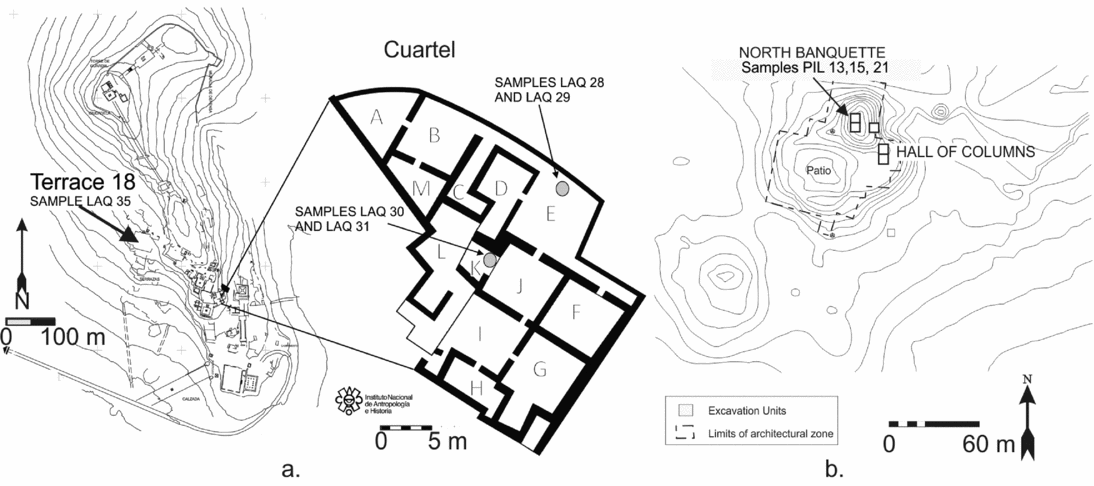
The Cuartel is a room complex overlooking the central site core. In the 1950s and 1960s Pedro Armillas conducted excavations in the Cuartel (Armillas Reference Armillas1963; Trombold Reference Trombold1990). Most of his records are now lost, but his artifact collection is intact and undergoing analysis at Arizona State University. Numerous wood samples were collected during these excavations, but due to the passage of time since excavation, most are in very poor condition and their fragments generally have short ring counts. One sample, however (INAH 16), still had more than 40 rings and is discussed below.
Recent excavations in adjacent rooms, directed by Marco Antonio Santos Ramírez in 2012–2014, provide more in-depth understanding of this room complex (Santos Ramírez Reference Santos Ramírez2014). The complex had two major construction phases. The oldest, a single-story structure in the shape of a half-moon, was relatively small and likely ceremonial in function. The space was later remodeled into a two-story masonry structure, different than the adobe found in most other sectors of the site. The generally more substantial construction materials and high frequency of fine ceramics suggest that this area housed an elite population (Jiménez Betts Reference Jiménez Betts2004; Santos Ramírez Reference Santos Ramírez2014). The 13 interconnected rooms on the ground floor were closed to the public and intentionally separated, perhaps for separate governing lineages. The upper floor seems to have been used for more public social activities (Santos Ramírez Reference Santos Ramírez2014). Some fallen beams, probably used as roof supports between the two floors, were found within these rooms. The beams were very well preserved, some partially charred, along the still-plastered walls (Notimex 2013). These beams, along with some of the wood recovered by Armillas discussed above, provide the first assemblage for dendrochronological applications (samples INAH 16 and LAQ 28–32).
Los Pilarillos Hall of Columns
Los Pilarillos is located on the valley floor at the confluence of two arroyos (Figure 2). Although substantially smaller than La Quemada, it appears to have been an important site. It is connected by a number of roads, and like elite construction areas at La Quemada, has formal masonry architecture on at least one side of a large sunken plaza. Excavations conducted by Nelson in the 1990s revealed a building analogous to the Hall of Columns found at La Quemada and other important sites on the northern frontier (Torreblanca Padilla Reference Torreblanca Padilla and Viramontes Anzures2014), and a carefully constructed high mound on the North Banquette, which may have supported a small pyramid and adjacent rooms (called North and East Rooms; Nelson and Schiavitti Reference Nelson and Schiavitti1992; Nelson et al. Reference Nelson, Weintraub and Schiavitti1993). Charred beam fragments were recovered among the adobe blocks, stone remains, and reeds in the fill above the floors of these rooms. These fragments make up a charcoal assemblage of 33 discrete samples.
Until now, best efforts to date the two sites have employed radiocarbon data that have only led to broad chronological estimates—for example, AD 550–800 (Nelson Reference Nelson1997:103–105). Employing a Bayesian chronological modeling approach (Bronk Ramsey Reference Bronk Ramsey2009a, Reference Bronk Ramsey2009b; Zeidler et al. Reference Zeidler, Buck and Litton1998), today we can do a little better. Figure 3 illustrates a reanalysis of the Nelson (Reference Nelson1997) dates from La Quemada, which results in a largely similar main phase terminus post quem (TPQ) for the two main datasets from Terrace 18 and Midden 11, respectively, cal AD 711–825 and cal AD 707–808 at 68.2% highest posterior density (HPD). The initial phase short-lived sample (B-77239, a corncob) sets a TPQ for the data in the model and is likely placed at AD 660–723. These dates suggest a more restricted age range for the site compared to previous estimates (AD 550–800).
A reanalysis of the radiocarbon data for La Quemada in Nelson (Reference Nelson1997) using Bayesian chronological modeling employing OxCal (Bronk Ramsey Reference Bronk Ramsey2009a, Reference Bronk Ramsey2009b) and IntCal13 (Reimer et al. Reference Reimer, Bard, Bayliss, Beck, Blackwell, Bronk Ramsey, Buck, Cheng, Edwards, Friedrich, Grootes, Guilderson, Haflidason, Hajdas, Hatté, Heaton, Hoffmann, Hogg, Hughen, Kaiser, Kromer, Manning, Niu, Reimer, Richards, Scott, Southon, Staff, Turney and van der Plicht2013).

Lab Methods and Analysis
Basic Principles of Dendrochronology
Dendrochronological analysis is based on two basic principles (Fritts Reference Fritts1976; Schweingruber Reference Schweingruber1988; Speer Reference Speer2010). First, tree species suitable for dendrochronology produce one visible tree ring per year as the response to growth conditions. Each annual tree ring usually includes a rapid growing season when conditions are favorable, producing earlywood, and one of more slow growth, called latewood, with a dormant phase with no growth between each annual increment. These changes are evident in fluctuations in tissue density, color, and cell size within each ring. The number of annual rings in the cross section of a tree records the biological age of the tree. The outermost ring in a sample represents the last year of growth. Bark or waney edge, the ring immediately below bark, represents the year in which the tree was cut down, and its presence is important for archaeological interpretation.
Second, annual-ring widths vary in response to changing climatic and environmental factors, such as temperature and rainfall, producing wider rings when conditions are favorable and narrower rings when conditions are poor (Fritts Reference Fritts1976). Despite individual circumstances and histories, trees of the same species in the same geographic area under similar climatic and environmental constraints produce over time similar ring-width growth patterns. Bringing the two basic principles together, dendrochronology matches the unique growth pattern between trees and site chronologies to relatively date them against each other.
Breaking down the two principles, a successful application of dendrochronology requires the following preconditions: (1) tree species with annual growth rings, (2) multiple samples per species, (3) generally 50 or more rings per sample, (4) trees that grew in the same climatic region, (5) trees that grew during the same time period, and (6) growth response mainly associated with climate and not specific microscale environmental conditions. When sampling multiple living trees, all but the last are usually immediately apparent. In an archaeological setting, however, all six preconditions must be considered.
In order to address the preconditions of archaeological wood samples for dendrochronological analysis, a clear view of the ring boundaries and cells on the transverse surface is necessary to evaluate annual-ring growth, ring count, and species identification. Sketches and photographs of the samples are taken before sample preparation because the preparation process is partially destructive. Wood segments of unburned timbers are prepared by sanding the transverse surface to a high polish with a progressive series of coarse to very fine sandpapers. Charred samples are prepared by sanding or scraping with a fine razor and blowing away the dust. If the sample is fragile, it is prepared by snapping it to create a fresh break. After preparation, samples are inspected under stereo, or dissecting, microscopes or scanning electron microscopes to identify genus and species, if possible, and to make an initial ring count. Genera and subgenera types of species are classified using anatomical characteristics, primarily on the basis of the transverse surfaces.
All samples in our collection have annual rings, meeting precondition 1. Precondition 2, multiple samples of the same species, is minimally fulfilled and cautiously accepted, as explained below. Of the assemblage, 17 of the samples contain more than the ~50 rings required in precondition 3. Precondition 4 is met by the restrictions in transport technology at the time, giving a high probability that the trees felled for construction were all from the same climate zone in the Malpaso Valley. Additional confirmation of preconditions 5 and 6 are generally supported by the analysis as presented in the results sections below.
Due to poor preservation and friable conditions, species-specific attributes are difficult with archaeological wood remains, especially when charred. In addition, many pine species have similar wood anatomical features that are not diagnostic at species level (Schweingruber Reference Schweingruber1988). In the state of Zacatecas, there are currently 12 species and varieties of pine, with successful hybridization between many (Martínez Reference Martínez1948), and more species were likely during the occupation of the site. Although we hesitate to identify the archaeological samples to the species level, all are pines. We conservatively identified four subgenera types by differences in the abruptness of early- to latewood transition, the width of latewood, and the distribution and size of resin ducts (Table 1). There are at least four samples of each type in our collection.
Description of Samples from the La Quemada and Los Pilarillos Sites.

a The widest part of the sample, or diameter and length if noted.
b Relative dates to each other, based on cross dates. Tentative cross dates are italicized.
c Type I: abrupt earlywood-latewood (EW-LW) transition, narrow LW, resin ducts throughout rings; Type II: gradual EW-LW transition, wide LW, numerous large resin ducts; Type III: gradual EW-LW transition, narrow LW, very occasional ducts mainly in LW; Type IV: abrupt EW-LW and wide LW, resin ducts mainly in LW, smaller and less numerous than Type II.
Measuring and Cross-Dating Samples
For the La Quemada and Los Pilarillos collections, all samples with ring counts greater than 40 were measured using a standard binocular microscope and measurement stage at 0.01 mm precision. Ring widths were measured twice along each radius, with a minimum of two radii per sample. Measurements were carefully reconciled within single sample sequences and their radii combined before attempting to cross-date with the tree-ring sequences of other samples, and additionally reconciled when missing or false rings were apparent in between-sample comparisons. For samples that had many fragments from the same tree, the larger fragments were measured and the resulting measurements combined when visible characteristics of ring patterns could be fit together.
The ring-width sequences in samples from the same site and contexts were compared for possible cross dating, using the established dendrochronological methods of visual comparison, distinctive marker years, and supporting statistical tests (Cook and Kairiukstis Reference Cook and Kairiukstis1990), including Student's t-score, intercorrelation, and trend coefficients provided by Tellervo and COFECHA software (Brewer Reference Brewer2014; Holmes Reference Holmes1983). A trend coefficient is the percentage of increases or decreases in year-to-year ring widths that are the same in the overlap between samples. Successfully cross-dated samples in the same context were combined into chronologies. The chronologies and single samples from different contexts were then compared, and again, if any of those sequences cross-dated successfully, those datasets were combined. Once the chronologies were compiled for each site, they were compared with each other and with samples that lacked successful within-site cross dating. By this method, we could determine if the two sites were occupied at the same time.
Placing Floating Tree-Ring Chronologies in Absolute Time
The methods described above demonstrate how a tree-ring chronology is constructed. When an archaeological chronology is produced for a species, time period, and geographic region for which there are no established calendar-dated reference chronologies to place it in absolute time, then it is considered a “floating chronology.” A radiocarbon date on samples used in the chronology can place the chronology approximately in time. A tree-ring radiocarbon “wiggle-match,” however, achieves a more specific and precise placement with a much smaller relative error (Bayliss Reference Bayliss2007; Bronk Ramsey et al. Reference Bronk Ramsey, van der Plicht and Weninger2001; Galimberti et al. Reference Galimberti, Bronk Ramsey and Manning2004).
Our tree-ring chronologies give relative dates of the tree rings in the timbers from several cultural contexts at the two sites and suggest their chronological order relative to each other. Since there are no reference chronologies, they are floating in time. The wiggle-match method helps to obtain the absolute dates by creating a dataset of multiple 14C dates separated by the number of rings between the dated tree-ring segments. For this purpose, after cross-dated sequences were combined into chronologies, samples were chosen for 14C dating. Generally, one or two samples were chosen from each chronology, plus single samples chosen for their long ring sequences or culturally meaningful contexts. From each sample, a series of decadal-scale sequential ring segments were selected and cut for radiocarbon dating. For each wiggle-match, a dataset was compiled of the 14C dates placed along the same timeline as their respective segments and fitted to the IntCal13 northern hemisphere international radiocarbon calibration curve (Reimer et al. Reference Reimer, Bard, Bayliss, Beck, Blackwell, Bronk Ramsey, Buck, Cheng, Edwards, Friedrich, Grootes, Guilderson, Haflidason, Hajdas, Hatté, Heaton, Hoffmann, Hogg, Hughen, Kaiser, Kromer, Manning, Niu, Reimer, Richards, Scott, Southon, Staff, Turney and van der Plicht2013) using the D_Sequence function in the OxCal software (Bronk Ramsey et al. Reference Bronk Ramsey, van der Plicht and Weninger2001). The results of wiggle-matches are reported by quoting the mean ± sigma (μ ± σ) of the modeled probability distribution of the wiggle-match. Ranges, when cited, are for the 68.2% (and 95.4%) highest posterior density (HPD) intervals (n.b., these are not 1σ [and 2σ] ranges because the calibrated and/or modeled ranges are not symmetrical probability distributions). The success of a wiggle-match depends on identifying a unique fit, which is typically affected by the length of the sequence, number of tree-ring sequenced data, and the shape of the radiocarbon calibration curve in the relevant period.
Determining the Years of Construction and Occupation
Determining the year in which a tree was felled is the key to establishing construction dates and occupation range. The outermost ring, indicated by the presence of bark or waney edge, is the last ring of growth and the year in which the tree died.
Once the tree-ring datasets have been absolutely dated, the construction and occupation dates are determined by the end dates of the samples. For each sample, if the outermost growth ring is at the waney edge, then the date of its outer ring is the felling date and indicates the earliest date range for the cultural use of the tree. For timbers found at archaeological sites, however, the waney edge is frequently missing due to preparation of the wood for construction or natural decay. So the dates of the outer extant ring in these samples give a “felled after” date (TPQ), indicating that construction had to be later than that year.
Results
Here we present the initial results of the dendrochronological and radiocarbon wiggle-matching methods for the Malpaso Valley sites of Los Pilarillos and La Quemada. We begin with the dendrochronological results for each structural context, then compare contexts within each site. Next, we compare the two sites. Finally, we present the results as absolute dates by considering radiocarbon assays and the wiggle-match analysis.
Cross-Dated Samples from within Sites in the Malpaso Valley
La Quemada
We collected seven samples from the 2012–2014 Cuartel excavations at La Quemada (LAQ) and inspected 22 more stored from the Armillas excavations in the 1960s. One additional sample was collected from the temple on Terrace 18 (Figure 2). Most of the samples in the Armillas collection had disintegrated, and only two had enough rings to meet precondition 3. The 10 La Quemada samples that meet most of the preconditions discussed above represent two pine types, Types I and III, and five samples have more than 50 rings (Table 1).
Three samples from the Cuartel (LAQ 28 and 29 from Room E and LAQ 30 from Room K) cross-dated and were combined to form a La Quemada chronology that is 90 years in length (Figure 4). All are Type I pines. The outer rings of both samples from Room E are continuous along most of their circumferences, suggesting the rings were very close to the last growth ring before the tree was felled. This implies that the construction of Room E occurred in relative year (RY) 1075 or very soon after. The cross-dated sample from Room K ends in RY 1090, and its outer ring is also very close to the waney edge, indicating that the wood was cut not long after RY 1090, putting the date of construction for Room K about 15 years after the construction of Room E. An additional sample from Room K, LAQ 31, is of Type III species and does not cross-date with the others but is discussed later.
Cross-dated tree-ring sequences of three samples (LAQ 28–30) representing two pine species from the La Quemada Cuartel, Malpaso Valley, Zacatecas, Mexico.

At Terrace 18, the sample LAQ 35, a Type III pine, has only 39 rings, which makes cross dating questionable. Nevertheless, we highlight it here as it may be an important bridge between other samples from the site and because it was found in a different context (Table 1). We discuss it in terms of wiggle-matching later. Similarly, LAQ 16, from the original Armillas Cuartel collection, has 56 rings and provides an important time marker for the Cuartel occupation.
Los Pilarillos
Thirty-three samples were collected from three areas at Los Pilarillos, the North and East Rooms in the North Banquette and from the East Banquette. All samples are of pine species Types II and IV. Each sample was broken, some with as many as 14 fragments. Twelve samples have more than 50 rings and are close to meeting the minimum preconditions for dendrochronological analysis.
Two samples from the North Room of the North Banquette (PIL 13 and PIL 21) are of Type II pines and cross-date, ending only a year apart (Figure 5). Neither sample has a definitive waney edge, but since their outer ring dates are within a year of each other, and the rings extend around 25% of their circumferences, it is logical to think that they were cut at the same time. The samples were combined into a Los Pilarillos chronology, 106 years in length.
Cross-dated tree-ring sequences of two samples (PIL 13 and PIL 21) from two contexts at Los Pilarillos, Malpaso Valley, Zacatecas, Mexico.

PIL 15, also from the North Room of the North Banquette and of Type II pine, is composed of two measured fragments, neither of which suggests a close proximity to a waney edge. The lack of waney edge indicates that we can only give the outer ring a “felled after” date. The average ring width, about 0.2 mm, is so small that many rings easily could have broken off.
Cross Dating between Malpaso Valley Sites
The successful cross dating within each of the two Malpaso Valley sites indicate that cross dating should be possible between Los Pilarillos and La Quemada and, if so, would be an indication that their occupations were contemporaneous. This between-site cross dating was confirmed, with good statistical support, by matching growth patterns in the La Quemada chronology with the Los Pilarillos chronology (Figure 6). The cross date also indicates that the two species, Types I and II, respond similarly to the same climate parameters. This cross date puts the end date of the Los Pilarillos chronology at RY 1134, ending 44 years later than the La Quemada chronology.
Cross-dated sequences from samples from La Quemada and Los Pilarillos. (a) Relative dates of samples from La Quemada and Los Pilarillos. Dotted lines indicate tentative cross dates due to very short overlaps. Placement is validated by 14C dates. (b) The same sample chronologies plotted along a single axis.

An additional cross date was successful between the La Quemada and Los Pilarillos chronologies and a single sample, PIL 15, also from the Los Pilarillos North Banquette, ends at RY 1069, 65 years earlier than the Los Pilarillos chronology. Due to the short 41 years of overlap, the relative cross date of the two Los Pilarillos sequences had not been identified when initially comparing the Los Pilarillos samples. Adding PIL 15 to the original Los Pilarillos chronology of PIL 13 and 21 creates a revised 126-year chronology that increases the visual similarity and supporting statistics with the La Quemada chronology (Figure 6, Table 2).
Supporting Statistics for Cross Dating between La Quemada and Los Pilarillos Samples and Sites.

Finally, the placement of a second tentative cross date between LAQ 16 and the Los Pilarillos chronology is supported by 14C wiggle-matching (Tables 2 and 3, Figures 6 and 8). LAQ 16 and the outer two samples of the PIL chronology all contain close-to-waney edges and end at approximately the same year, RY 1134, suggesting their construction occurred around the same time.
Radiocarbon Dates of Segments from Four La Quemada and Two Los Pilarillos Samples.
Wiggle-Matches and Placement of Single Samples
The dendrochronological analysis provides relative dates of construction at the two sites and gives them contemporaneity and chronological order. The radiocarbon wiggle-match methodology supports the cross-dating of the two chronologies and relative order by placing them in absolute time.
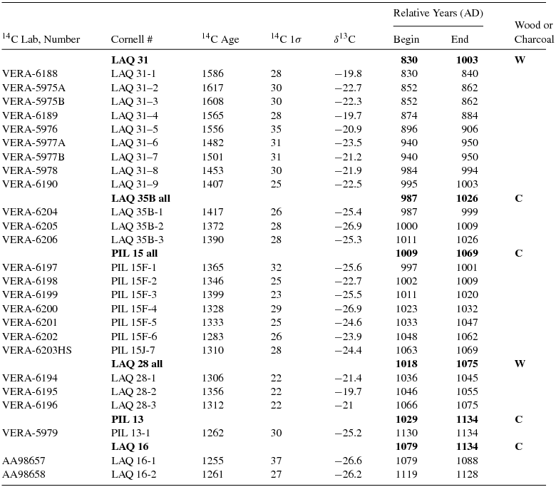
As mentioned above, longer sequences have the greatest potential for successful wiggle-matching. Sample LAQ 31 from Room K of the La Quemada Cuartel, where LAQ 30 was also found, was selected because it contains 174 rings, its outer ring is very close to the waney edge, and it is a Type III pine variety. After ring widths were measured, seven tree-ring segments were dissected, each variously of 9–11 years but with known tree-ring intervals between them. The resultant 14C ages were then fitted against IntCal13 (Figure 7 and Table 3; Reimer et al. Reference Reimer, Bard, Bayliss, Beck, Blackwell, Bronk Ramsey, Buck, Cheng, Edwards, Friedrich, Grootes, Guilderson, Haflidason, Hajdas, Hatté, Heaton, Hoffmann, Hogg, Hughen, Kaiser, Kromer, Manning, Niu, Reimer, Richards, Scott, Southon, Staff, Turney and van der Plicht2013). Application of the wiggle-match methodology placed the end of the sample sequence (RY 1174, four years later than the midpoint of the last dated tree-ring sample) at cal AD 636–655 (68.2% HPD).
Radiocarbon wiggle-match of LAQ 31. Main panel: placement of the tree-ring sequenced ring segments of LAQ 31 on the IntCal13 radiocarbon calibration curve (Reimer et al. Reference Reimer, Bard, Bayliss, Beck, Blackwell, Bronk Ramsey, Buck, Cheng, Edwards, Friedrich, Grootes, Guilderson, Haflidason, Hajdas, Hatté, Heaton, Hoffmann, Hogg, Hughen, Kaiser, Kromer, Manning, Niu, Reimer, Richards, Scott, Southon, Staff, Turney and van der Plicht2013). The black boxes indicate the 68.2% probability ranges of the 14C dates (y axis) and the modeled 68.2% highest posterior density (HPD) calibrated calendar age ranges (x axis). Inset: modeled calibrated calendar age probabilities for the midpoint (relative year [RY] 170) of the last dated tree-ring sample from LAQ 31 (RY 166–174). The last extant tree ring from the LAQ 31 sample (RY 174) is four years later than this midpoint. Data from OxCal 4.3.1 (Bronk Ramsey Reference Bronk Ramsey2009a).

The wiggle-match of the LAQ 31 radiocarbon dates explained the lack of cross dating between it and the Los Pilarillos and La Quemada chronologies, and most other 14C-dated samples, because its absolute dates do not overlap the time period represented by the other samples. Another sample, LAQ 35, the only sample from the Terrace 18 temple at La Quemada, contained only 40 rings and likewise did not cross-date with either LAQ 31 or the combined site chronologies. Nonetheless, the wiggle-match of three 14C-dated segments from the Terrace 18 sample places it tentatively between the LAQ 31 sample and the two site chronologies (Figures 6 and 8). Finally, the placement of a second tentative cross date, between LAQ 16 and the Los Pilarillos chronology, was supported by the 14C wiggle-matching. The outer samples of the two site chronologies and LAQ 16 all contain close-to-waney edges and end at approximately the same year, suggesting their construction was around the same time.
Radiocarbon wiggle-match of all the tree-ring sequenced radiocarbon dates on the combined LAQ and PIL chronology best fitted to the IntCal13 radiocarbon calibration curve (Reimer et al. Reference Reimer, Bard, Bayliss, Beck, Blackwell, Bronk Ramsey, Buck, Cheng, Edwards, Friedrich, Grootes, Guilderson, Haflidason, Hajdas, Hatté, Heaton, Hoffmann, Hogg, Hughen, Kaiser, Kromer, Manning, Niu, Reimer, Richards, Scott, Southon, Staff, Turney and van der Plicht2013) employing OxCal 4.3 (Bronk Ramsey Reference Bronk Ramsey2009a; Bronk Ramsey et al. Reference Bronk Ramsey, van der Plicht and Weninger2001). The five cross-hatched dates are identified as outliers by the simple outlier model in OxCal (Bronk Ramsey Reference Bronk Ramsey2009b). The model rerun without these outliers shows excellent agreement, with OxCal Amodel and Aoverall values of respectively 193.5 and 195.2, well above the satisfactory threshold value of 60. The span of the Los Pilarillos and La Quemada chronologies is from RY 830 to 1134. The modeled calendar age probability distributions, the 68.2% and 95.4% most likely ranges, and the mean (μ) ± standard deviation (σ) for the first and last tree rings in the chronology from the rerun minus outliers are shown as insets and above.

Wiggle-Matching the Combined Samples
The error range can be even further reduced, and cross dating further confirmed, by coordinating more of the 14C dates from the La Quemada and Los Pilarillos samples. Using the relative dates from the tree-ring sequences in Figure 6a, a wiggle-match based on 25 radiocarbon dates along the complete chronology significantly reduces the dating fit range to ±4 calendar years (μ ± σ of the wiggle-match posterior density distribution; Figure 8). Five dates do not neatly fit on the radiocarbon calibration curve and are possible outliers, though their exclusion does not significantly alter the dates obtained from employing all 25 14C dates—moving the mean (μ) fit point for the start of the tree-ring chronology two years older. The “cleaned” wiggle-match places the 305-year chronology at cal AD 466 to 770 ± 4, which places the dates for minimal occupation at cal AD 639 to after 770, with the construction events at La Quemada occurring soon after cal AD 639, 661, 711, 726, and 770 (RY 1003, 1025, 1075, 1090, 1134, respectively; Table 3 and Figure 6) and a building construction after AD 770 for Los Pilarillos (RY 1134; Figure 8). All dates have a ±4-year error quoting the μ ± σ of the wiggle-match posterior density distribution. Conservatively, the overall 95.4% HPD range is −9/+8 years.
Cross Dating between Pinus Types
Even if they are contemporaneous, different species can have different climate responses so that their tree-ring growth patterns may not cross-date. While all our samples are Pinus spp., this possibility was a concern due to the multiple Pinus sp. types represented at both sites. As noted above and listed in Table 1, four types of pine species are represented in the collection, and the La Quemada samples include species Types I and III with the Los Pilarillos samples representing species Types II and IV and a few samples of Type III (Table 1). Samples of only Type I make up the La Quemada chronology of Cuartel Rooms E and K, and in the Los Pilarillos North Banquette chronology only Type II species are represented. The successful cross dating between the two chronologies indicates that Type I and II species have similar climate responses in their growth patterns. For species Types III and IV there is no supporting evidence of similar growth patterns between them or the other species types, but that is not necessarily an indicator of different growth responses. Other reasons for the unsuccessful cross dating of those samples may be differences in represented time periods and short overlaps, as indicated by the earlier dates of LAQ 31 and the short sample LAQ 35, or, perhaps, a stronger nonclimatic growth response in these samples that masks the climate signal in the parent trees. The latter reason is suggested by the absence of cross dates between all the Type IV samples from the same context at Los Pilarillos.
The total number of samples (25) is small, but the species distribution could be culturally significant. The exclusive use of Type I pines at La Quemada Cuartel Rooms E and K and Type II in the North Banquette of Los Pilarillos suggests that those particular species were each chosen for their respective buildings. Type III is the only type represented at both sites and suggests preference or availability, but the suggestion must be used with caution because only two samples of that type were found at each site. The chronological order of the types at La Quemada (from the early samples of Type III to the later of Type I) and the 174-year lifespan of LAQ 31, however, may indicate that species Type III was plentiful when the site was first settled but that its availability quickly became limited (although pine types are not distinguished, Elliott [Reference Elliott, Badal, Carrión, Macías and Ntinou2012] finds an overall stable use of wood in the Pinus genus during the La Quemada occupation). Whether the selection of the different types reflects cultural preferences for specific wood characteristics, availability of the species, or a combination of the two is unknown but worth further research.
Discussion
We have made significant progress in cross-dating archaeological tree-ring samples and wiggle-matching their radiocarbon ages to place the resulting chronologies in real time and to begin to demonstrate the potential for tree-ring dating for the first millennium AD in northwestern Mexico. If we make the assumption that the last extant rings on all but one sample are close to or at the bark and therefore within a few years of the felling date, we offer the following preliminary chronological findings and possible cultural interpretations. All of the cal AD dates below have ±4 range and represent the μ ± σ dates from the tree-ring chronology in Figure 6 and the wiggle-match in Figure 8.
The Cuartel
Both ring measurement and wiggle-match results show that three beams from Rooms E and K within the Cuartel complex (LAQ 28–30) were cut within ~20 years of each other, after cal AD 711 ± 4 for Room E and for Room K after cal AD 726 ± 4 (μ ± σ). One beam from the same room (LAQ 31) suggests an earlier construction, after cal AD 639 ± 4 (μ ± σ). Given the size, strength, and good preservation of these samples, we assume that they were used as roof support beams. Room K in particular was a multistory interior room (Santos Ramírez Reference Santos Ramírez2014), which would have required substantial structural support. The fact that the two samples (LAQ 30 and 31) were found side by side in the same context, but the preserved tree rings and likely use dates are as much as 100 years apart, could support the remodeling interpretation proposed by Santos Ramírez (Reference Santos Ramírez2014). Perhaps the early beam was used during the initial construction phase, after cal AD 639 ± 4 (μ ± σ), and due to its good condition was recycled during the second construction phase when the other beams were cut, sometime after cal AD 726 ± 4 (μ ± σ).
In terms of a broader chronological interpretation regarding the Cuartel's construction within the structural development of the site of La Quemada, our chronological evidence, compared with other radiocarbon dates from other researchers, suggests that the Cuartel dates fit within the broad range of dates suggested previously (AD 500–800; Nelson Reference Nelson1997; Trombold Reference Trombold1990). More specifically, the later part of this wide range, after circa cal AD 639 to after circa cal AD 770, is consistent with the reanalysis of Nelson's (Reference Nelson1997) radiocarbon dates shown in Figure 3. These dates, combined with the prominent location of the Cuartel and its proximity to the central core, support the hypothesis that the Cuartel is one of the earliest constructions at La Quemada (Santos Ramírez Reference Santos Ramírez2014). The tree-ring 14C wiggle-match date indicate that the reconstruction of the Cuartel (around cal AD 770 ± 4) potentially coincides with the beginning of the Terrace 18 construction episode during the late eighth century AD. We emphasize that this interpretation is based on minimal data and should be used only as a hypothesis to be tested by future information, and not to reorient the regional chronology.
The last extant tree ring in a sample from a possible beam in the temple on Terrace 18 (LAQ 35) dates to cal AD 661 ± 4. Previously published dates from the immediate surrounding architecture in the same room (Nelson et al. Reference Nelson and Millhauser1997) indicated a range between approximately cal AD 600 and 740. In comparison, the LAQ 35 date seems like a plausible initial construction date. This TPQ date is consonant with the most likely modeled calendar age range for the corncob (B-77239) found at the base of the Terrace 18 construction (cal AD 660–723, 65.8% HPD range, shown in Figure 3). If our new dates are representative of cutting and building, then these dates for Terrace 18 are also consistent with the early date from the Cuartel, suggesting widespread site construction within a few years.
Los Pilarillos
As Los Pilarillos is substantially smaller than La Quemada, although still more elaborately built than most other valley sites, the relationship between the two is of particular interest to understanding Malpaso Valley cultural dynamics. Dendrochronology measurements and cross dating (Figures 6 and 8) place samples PIL 13 and PIL 21 from roof fall in a large room on the highest mound at cal AD 770 ± 4 (μ ± σ), about 50–100 years later than the majority of beams in the Cuartel (LAQ 28–31) and the Terrace 18 temple construction. This later date is consistent with two interpretations. First, the monumental architecture at Los Pilarillos could have been built significantly later than the Cuartel and Terrace 18. In fact, PIL 15 (the other sample included in the cross date) while earlier than the other two Los Pilarillos samples, may indicate later construction than the La Quemada dates due to its lack of waney edge and context. Second, since these dates are from roof construction, we must consider this context most vulnerable to degradation due to exposure to weather, and therefore the beam might have needed to be replaced after initial construction. The hypothesis that Los Pilarillos was constructed more than 100 years after La Quemada may soon be addressed by ceramic seriation studies, which have identified some time-sensitive ceramic markers (Torvinen et al. Reference Torvinen, Kulow and Nelson2015). The contemporaneity of LAQ 16 indicates that La Quemada was still occupied at the time of the settlement of Los Pilarillos, but the single LAQ sample and its limited context do not allow further interpretation.
The successful cross dating of samples within each site and between the two site chronologies, plus the tentative placements of the single samples, all suggested and validated by their 14C dates, is an indication that with more samples, tree-ring measurements, cross dating, and 14C dating, a better understanding of chronological changes in the region is possible. Additional samples will augment the tree-ring data to form a reference chronology against which new samples can be cross-dated. A reference chronology is expected to correlate with tree-ring data from other sites in a larger region that can be used to reconstruct construction sequences and spatial and temporal relationships between sites. The construction of a robust chronology also will be the basis for the next step in this project, to provide a regional record of climatic variability recorded in the ancient tree rings to reconstruct past environmental conditions.
Conclusion
Although preliminary, these studies have produced optimistic results that dendrochronological methods are a viable source of study for northwest Mesoamerica and have the potential to address questions that require fine-scale chronologies that still elude archaeologists. Despite the fact that some of the cross-dated placements of wood samples from the Malpaso Valley are tentative due to the lack of sufficiently overlapping sequences, the confirmation of these placements by the 14C wiggle-match method is encouraging support that the placements are correct within a minor range of error. For example, these data suggest that the Hall of Columns–like structure at the site of Los Pilarillos was constructed about 50–100 years later than parts of La Quemada. Continued work with this collection and the addition of samples from new contexts, new sites, and neighboring regions, all of which we have initiated, should in the future provide a reference chronology that can be used to address more of these chronological questions.
Of course, the cultural interpretation is only as good as the data. Dendrochronological methods, even when they work perfectly, date the specific time at which the tree was cut down. Archaeologists must continue to interpret these dates with consideration of the culture and broader contexts in which the samples are found. In addition, one or more reference chronologies against which additional individual samples can be dated become more robust with potential for paleoclimatic analysis. In noting the need to expand the application, we conclude by taking advantage of this audience of practicing archaeologists with an offer to examine any archaeological wood that you may have from your excavations in this region. Although the method is partially destructive, the potential payoff is huge. With enough rings, samples may provide chronological data for your own sites and also contribute to an understanding of the prehistory of this dynamic region of Mesoamerica.
Acknowledgments
This work is supported by NSF Grant #BCS-1324106 and is a collaboration between Ithaca College, Cornell University, Arizona State University, the Instituto Nacional de Antropología e Historia (INAH Oficio 401.B(4)19.2014/36/0834), and the Laboratorio de Anillos de Arboles at the Instituto Nacional de Investigaciones Forestales Agrícolas y Pecuarias (INIFAP). In particular, we thank José Villanueva Díaz, Julián Cerano-Paredes, Brita Lorenzen, and Michelle Elliott for dendrochronological and wood identification help. Alexandra Jiggetts-O'Neill, Katherine Seufer, Daniel Weller, Zoe Carlson, Sarah Butler, and James Landahl made indispensable contributions to field and laboratory work. Thanks also to Oralia Cabrera Cortés for preparing the Spanish abstract.
Data Availability Statement
The wood and charcoal samples, as well as the digital data, analyzed in this paper are held at the Cornell University Tree-Ring Laboratory. Please contact the authors for more information.


 Open access