


Introduction
Pasture, rangeland, and forage areas extend over half of the total land area in the United States and provide a range of ecosystem services, including serving as a feed supply for livestock (Sanderson et al. Reference Sanderson, Jolley and Dobrowolski2012; USDA 2017; Teague and Kreuter Reference Teague and Kreuter2020). However, adverse weather can reduce the feed supply on these predominantly rainfed lands and harm the livelihoods of livestock producers (UGA 2017; Volesky Reference Volesky2021). To help protect producers against such adverse conditions, the U.S. Department of Agriculture’s Risk Management Agency (RMA) launched a pilot rainfall index insurance program in 2007 for pasture, rangeland, and forage areas in the continental U.S. that indemnifies agricultural producers against the financial risks of the single peril of anomalously low rainfall (Willis Reference Willis2019). In contrast to insurance programs that pay producers based on loss claims, the Pasture, Rangeland, and Forage Rainfall Index (henceforth PRF) program pays producers when observed rainfall (i.e., the index) in the covered region falls below a predetermined threshold value (the coverage or ‘strike’ level). A key benefit of indexed programs is that they can provide quick payouts based on an observable and verifiable proxy of poor conditions. However, a frequently noted challenge with index insurance is the mismatch between the chosen index and the actual losses experienced by the insured, known as basis risk (Clarke Reference Clarke2016; Jensen et al. Reference Jensen, Barrett and Mude2016; Jensen et al. Reference Jensen, Mude and Barrett2018; Clement et al. Reference Clement, Botzen, Brouwer and Aerts2018; Yu et al. Reference Yu, Vandeveer, Volesky and Harmoney2019; Keller and Saitone Reference Keller and Saitone2022). Although basis risk can arise from many factors, this manuscript focuses on potential design errors associated with spatial basis risk. In short, spatial basis risk refers to how weather conditions can vary across a given area, meaning a single index may fail to adequately capture conditions and experiences over a large space (Clement et al. Reference Clement, Botzen, Brouwer and Aerts2018).Footnote 1 For instance, an insurance policy based on regional rainfall levels may obscure sub-regional variations, leaving some policyholders with losses but without corresponding payouts. This scenario results in a policyholder being worse off than without insurance – as the policyholder both pays the premium to purchase insurance but does not receive the expected cushion against downside conditions. Similarly, payouts can occur among those who are not suffering losses, rendering the program more expensive overall as well as potentially affecting perceptions of program performance. However, recent changes in data availability and innovations in geospatial processing techniques have unlocked the ability to resolve conditions at a finer scale than before. A key premise of our work is that employing spatially explicit approaches to evaluate datasets with different abilities to detect perils – e.g., with varying spatial resolution – offers the potential to help policy designers identify opportunities to reduce spatial basis risk. In particular, highlighting areas with greatest uncertainty across measures could help identify areas for strategic ground sampling or exploring new, more spatially targeted policy design options.
In particular, this paper examines the case of two different precipitation measures – one at coarser resolution used by the current PRF program and another at finer spatial resolution increasingly used by other relief programs throughout the world – to quantify the frequency and magnitude of differences emerging from the use of such newer, more finely resolved precipitation estimates. We represent such differences spatially as well as translate them into estimated dollar amounts corresponding to what would have happened if the finer spatial resolution data were applied to observed enrollment for the years 2012 to 2023 in the state of Texas, intentionally selected as the state with the largest number of policies and payouts since the program’s launch. Specifically, this work examines three questions associated with changing input datasets used to estimate what is, nominally, the same underlying weather condition (i.e., rainfall):
-
1. How much rainfall variation does finer spatial resolution data reveal in the current program?
-
2. How much do payout determinations differ?
-
3. How would the magnitude of payouts differ?
Related work and contributions
This work seeks to contribute to three main literatures: (1) the design and implementation of index-based insurance, particularly in the context of weather and spatial variability, (2) the quantification and management of basis risk in agricultural index insurance, and (3) the evaluation and application of alternative indicators for evaluating index insurance outcomes.
The literature on the design and implementation of index-based insurance has long emphasized the potential of using environmental indicators to provide a low-cost way to mitigate production risks, with early conceptual models based on rainfall originating in India in the early twentieth century (Chakravarti Reference Chakravarti1920). Most modern applications of index insurance emerged in the late 1990s, often relying on weather-based indices such as rainfall or proxies for biomass growth to indemnify producers (Benami et al. Reference Benami, Jin, Carter, Ghosh, Hijmans, Hobbs, Kenduiywo and Lobell2021). Such index-based designs are often especially valuable where a claims-based system would be prohibitively costly to administer, such as in developing country smallholder contexts (Carter et al. Reference Carter, de Janvry, Sadoulet and Sarris2017; Benami and Carter Reference Benami and Carter2021) or where coverage extends over large expanses that make on-site production assessment infeasible, such as the now many programs focused on grasslands or other livestock feed production areas (Vroege et al. Reference Vroege, Dalhaus and Finger2019; Benami et al. Reference Benami, Jin, Carter, Ghosh, Hijmans, Hobbs, Kenduiywo and Lobell2021). In the U.S., the PRF program exemplifies this latter use case while also illustrating challenges in managing spatial variability. For instance, from the vantage point of service as a former RMA administrator, Willis (Reference Willis2019) highlights limitations in the station-based design of the PRF: Especially for areas with highly varying topography – regions in which grazing may be one of the few suitable productive land uses – he argues that the use of sparse high-altitude weather stations to estimate rainfall results in insurance coverage gaps and warrants an alternative.
Another related literature on the quantification and management of basis risk has frequently shown that payouts in index-based insurance programs often do not align well with realized losses, resulting in substantial residual risks to policyholders. For example, Yu et al. (Reference Yu, Vandeveer, Volesky and Harmoney2019) compared PRF rainfall index values against local precipitation and historical forage yield data from three university-managed ranches located across the states of Nebraska and Kansas, finding that the PRF program would not have paid out 26–43% of the losses experienced in those example ranches. Similarly, Keller and Saitone (Reference Keller and Saitone2022) examine an alternative production estimate in California against the PRF payouts, concluding that up to 39% of production losses have likely been uncompensated. These works emphasize the importance of identifying and using indices that capture more of the spatial and environmental variability producers experience to reduce basis risk.
The potential for changing the choice of rainfall indicators is considered by Coble et al. (Reference Coble, Goodwin, Miller, Rejesus, Harri and Linton2020), who in an RMA-contracted review of the PRF program, provided some graphical evidence of differences between the program’s precipitation data and other potential datasets. However, the authors focused on differences in aggregate across the program and did not evaluate the spatial element of the program, and, in particular, whether some differences among datasets reflect systematic or persistent deviations that may warrant attention. Several other papers on agricultural index insurance consider alternatives to precipitation-based indices, including drought indices (Williams and Travis Reference Williams and Travis2019), ensembles of remotely sensed rainfall data (Black et al. Reference Black, Tarnavsky, Maidment, Greatrex, Mookerjee, Quaife and Brown2016), satellite-derived vegetation metrics (Carter et al. Reference Carter, de Janvry, Sadoulet and Sarris2017; Benami et al. Reference Benami, Jin, Carter, Ghosh, Hijmans, Hobbs, Kenduiywo and Lobell2021), and water capacity-based or soil moisture related measures (Kellner and Musshoff Reference Kellner and Musshoff2011; Vroege et al. Reference Vroege, Bucheli, Dalhaus, Hirschi and Finger2021) to improve payout accuracy, reduce basis risk, and enhance insurance design overall.
Our work builds on this literature by focusing on how variations in the input data source can affect payout decisions over space. Our approach is closely aligned with Williams and Travis (Reference Williams and Travis2019), who evaluated a series of alternative drought indices against forty years of production data from the U.S. Forest Service’s Rangeland Vegetation Simulator (Reeves and Frid Reference Reeves and Frid2016) and wheat production estimates from USDA (NASS Reference NASS2017). However, unlike Williams and Travis (Reference Williams and Travis2019), who examined alternative drought indicators, our analysis emphasizes the potential of an alternative dataset on the same nominal phenomenon (rainfall) but resolved at a finer spatial scale to identify patterns suggestive of spatial basis risk or potential misrating that can be improved.
Institutional context
The study focuses on the PRF program administered by the United States Department of Agriculture’s Risk Management Agency (USDA RMA). Launched in selected areas of the U.S. in 2007 and expanded across the continental U.S. in 2016 (RMA 2015),Footnote
2
the program offers insurance coverage to livestock producers and hay growers for forage losses due to low rainfall.Footnote
3
This program contrasts with many other Federal Crop Insurance Program initiatives and programs that rely on (largely self-reported) farm actual production histories to determine crop losses. The program also differs from the Livestock Forage Disaster Program that compensates livestock producers for grazing losses due to droughts as determined by U.S. Drought Monitor assessments. Across the continental U.S., the PRF program uses an estimate of precipitation across 0.25° grids (i.e., $\sim $
28 by 28 km, or
$\sim $
28 by 28 km, or $\sim $
17 by 17 miles at the equator) in size, which corresponds to the grid size used in the dataset with one of the longest records of precipitation estimates in the U.S. (described more in the Data and Methods). Notably, RMA announced they will use a 0.05° grid (i.e.,
$\sim $
17 by 17 miles at the equator) in size, which corresponds to the grid size used in the dataset with one of the longest records of precipitation estimates in the U.S. (described more in the Data and Methods). Notably, RMA announced they will use a 0.05° grid (i.e., $\sim $
5 km × 5 km grid at the equator) for estimating precipitation in the 2024 expansion of the PRF program to Hawaii (Risk Management Agency 2024a), further justifying our choice of using an alternative precipitation dataset at the same 5x finer spatial resolution to compare with the current program.
$\sim $
5 km × 5 km grid at the equator) for estimating precipitation in the 2024 expansion of the PRF program to Hawaii (Risk Management Agency 2024a), further justifying our choice of using an alternative precipitation dataset at the same 5x finer spatial resolution to compare with the current program.
Key program and producer policy choices
Producers must make several important decisions – mostly focused on selecting a relevant time period (“index interval”) and extent of coverage – in order to purchase a PRF policy. We highlight three of the most relevant decisions below that are also inputs for our subsequent analyses (elaborated further in each of the relevant methods sections). First, producers must select at least two non-overlapping index intervals to insure. Each index interval represents a consecutive two-month period (e.g., January–February or November–December) over which precipitation estimates are totaled.Footnote 4
Second, producers must select the rainfall index threshold (the “coverage level”) that triggers an indemnity payment, which ranges from 70 to 90% relative to the historical average for that given interval and that particular area (called a “grid”). Third, producers can also vary the extent of their protection through adjusting a “productivity factor” intended to reflect the producer’s perceived monetary value of their insured operation relative to others in the same county (Campiche and Jones Reference Campiche and Jones2017).Footnote 5 Producers can access historical estimates of payouts in their grid, tailored to different decisions on all of the above choices, through a USDA decision support tool (USDA 2024).
Methods and data
We analyze two precipitation datasets to examine their differences over space. We then compare payout determinations and magnitudes across Texas from 2012 to 2023, emphasizing results in 2021, which was a record year for enrollment and payouts at the time of this study’s inception.
Study area
Our study area focuses on the U.S. state of Texas. Spanning 695,663 sq. km (268,597 sq. miles), Texas possesses an economically significant cattle industry that heavily depends on pasture, forage, and rangelands distributed across the state, with notable concentrations of beef cattle operations in its northwest and southeast (NASS Reference NASS2017). The state is also of interest given its varying climatic conditions that can be broadly divided into arid and temperate areas. The western third of the state near the Trans-Pecos region exhibits desert-like, semi-arid conditions with less than 16 inches ( $\sim $
400) of annual average rainfall. In contrast, the eastern two thirds exhibit more temperate patterns consistent with Humid Subtropical or Oceanic Köppen–Geiger classifications, with highly variable rainfall typically totaling at least 30 inches (
$\sim $
400) of annual average rainfall. In contrast, the eastern two thirds exhibit more temperate patterns consistent with Humid Subtropical or Oceanic Köppen–Geiger classifications, with highly variable rainfall typically totaling at least 30 inches ( $\sim $
750 mm) throughout the year (PRISM 2022). For our historical baseline analyses, we categorize East and West Texas using Köppen–Geiger climate classifications (Godfrey and Molnau Reference Godfrey and Molnau1999). Specifically, West Texas is predominantly classified as arid (“B” group) and East Texas as temperate (“C” group), based on the majority classifications within a 0.5 × 0.5° grid cell (CPC grid) (Figure A.3).
$\sim $
750 mm) throughout the year (PRISM 2022). For our historical baseline analyses, we categorize East and West Texas using Köppen–Geiger climate classifications (Godfrey and Molnau Reference Godfrey and Molnau1999). Specifically, West Texas is predominantly classified as arid (“B” group) and East Texas as temperate (“C” group), based on the majority classifications within a 0.5 × 0.5° grid cell (CPC grid) (Figure A.3).
Corresponding to the large size of the state, economic significance of the livestock sector, and the wide climatic variation within the state, Texas was the state with the single highest enrollment ( $\sim $
36% share of all policies, Figure A.1) and most substantial payouts ($1.69 billion) in the PRF program since its inception (Figure A.2). The state also has one of the highest loss ratios across the country for the PRF program (Coble et al. Reference Coble, Goodwin, Miller, Rejesus, Harri and Linton2020), reflecting a high magnitude of payouts relative to premia collected. In this analysis, we investigate and simulate payout determinations across all 254 Texas counties from 2012 to 2023. We then compare how finer and coarser estimates of precipitation compare across space and examine the differences in the determinations and the magnitude of payouts that would arise using each resolution across Texas, with a focus on 2021. Figure 1 shows a summary of the key questions posed, methods employed, and data used in this study, which we then elaborate in the subsequent text.
$\sim $
36% share of all policies, Figure A.1) and most substantial payouts ($1.69 billion) in the PRF program since its inception (Figure A.2). The state also has one of the highest loss ratios across the country for the PRF program (Coble et al. Reference Coble, Goodwin, Miller, Rejesus, Harri and Linton2020), reflecting a high magnitude of payouts relative to premia collected. In this analysis, we investigate and simulate payout determinations across all 254 Texas counties from 2012 to 2023. We then compare how finer and coarser estimates of precipitation compare across space and examine the differences in the determinations and the magnitude of payouts that would arise using each resolution across Texas, with a focus on 2021. Figure 1 shows a summary of the key questions posed, methods employed, and data used in this study, which we then elaborate in the subsequent text.
Overview of primary research questions, methods, and data sources for analysis.

Data
To examine differences between the current precipitation estimates and more finely resolved ones, we primarily use three sources of data.
Current precipitation data: NOAA CPC
The PRF program uses the Climate Prediction Center’s Unified Gauge-Based Analysis of Global Precipitation from the National Oceanic and Atmospheric Administration (2023) to compute the rainfall index that, in turn, determines whether payouts (indemnities) are due. The gridded CPC data has a spatial resolution of 0.25° latitude by 0.25° longitude ( $\sim $
17 × 17 miles/28 × 28 km at the equator), and the rainfall index represents observed rainfall within a grid-interval divided by its historical average from 1948 until two years prior to the policy year (RMA 2022).
$\sim $
17 × 17 miles/28 × 28 km at the equator), and the rainfall index represents observed rainfall within a grid-interval divided by its historical average from 1948 until two years prior to the policy year (RMA 2022).
Alternatively stated, the rainfall index is the ratio of the observed rainfall ( $x$
) in interval-year (
$x$
) in interval-year ( $i,t$
) to the mean of the rainfall (
$i,t$
) to the mean of the rainfall ( $\bar x$
) in the same interval (
$\bar x$
) in the same interval ( $i$
) across all years (
$i$
) across all years ( $t$
) since the baseline start until two years before the policy year:
$t$
) since the baseline start until two years before the policy year:
 $$Index\left( {{x_{i,t}}} \right) = {{{x_{i,t}}} \over {{{\bar x}_{i,t - 2}}}}$$
We extract CPC precipitation data for 1948–2023 using the rnoaa package (rOpenSci 2025). To align with the first year of data availability for our alternative dataset, we use 1981 as the start of the historical reference period – henceforth, the baseline start year – in our main analysis.Footnote 6
Alternative precipitation data: CHIRPS
The Climate Hazards Group InfraRed Precipitation with Station data (CHIRPS) dataset, developed and maintained by The Climate Hazards Group at the University of California, Santa Barbara, provides an alternative gridded rainfall estimate. CHIRPS combines satellite imagery and ground station observations to provide daily rainfall and snowfall estimates across the globe at a 0.05° ( $\sim $
3 × 3 miles/5 × 5 km at the equator) spatial resolution. CHIRPS data span 1981 to the present, and the methods for their collection are elaborated in Funk et al. (Reference Funk, Peterson, Landsfeld, Pedreros, Verdin, Shukla, Husak, Rowland, Harrison, Hoell and Michaelsen2015). Briefly, in contrast to the CPC dataset, which focuses on interpolating data from thousands of stations throughout the U.S., CHIRPS focuses on estimates of cold cloud duration extracted from geostationary weather satellites to generate precipitation estimates that are then calibrated using station records. We extract CHIRPS data over the relevant time frame from Google Earth Engine (Gorelick et al. Reference Gorelick, Hancher, Dixon, Ilyushchenko, Thau and Moore2017) and use the same methods we did for CPC to calculate variation in rainfall relative to historical averages, with precipitation baselines starting in 1981 (Equation 1).
$\sim $
3 × 3 miles/5 × 5 km at the equator) spatial resolution. CHIRPS data span 1981 to the present, and the methods for their collection are elaborated in Funk et al. (Reference Funk, Peterson, Landsfeld, Pedreros, Verdin, Shukla, Husak, Rowland, Harrison, Hoell and Michaelsen2015). Briefly, in contrast to the CPC dataset, which focuses on interpolating data from thousands of stations throughout the U.S., CHIRPS focuses on estimates of cold cloud duration extracted from geostationary weather satellites to generate precipitation estimates that are then calibrated using station records. We extract CHIRPS data over the relevant time frame from Google Earth Engine (Gorelick et al. Reference Gorelick, Hancher, Dixon, Ilyushchenko, Thau and Moore2017) and use the same methods we did for CPC to calculate variation in rainfall relative to historical averages, with precipitation baselines starting in 1981 (Equation 1).
County-level data
Using the prior two datasets allows us to evaluate differences in precipitation estimates and payout determinations. To go one step further and generate payout estimates, we draw upon two USDA Risk Management Agency datasets. First, the USDA RMA Summary of Business data provide information on the number of policies sold, indemnities, acreage, premia, and subsidies on a per county basis, among other characteristics relevant for evaluating the magnitude of payouts for PRF. We use the Summary of Business data files disaggregated to the state-county-crop-coverage level-type-practice-unit structure so as to distinguish between different use types (e.g., haying/grazing, irrigated or not (Figure A.7)). In addition to the Summary of Business data, we also extract parameters needed to calculate payout magnitudes – e.g., county productivity (base) values – from the Pasture, Rangeland, Forage Decision Support Tool API (USDA 2024).Footnote 7 We associate all of these data to vector files that outline the borders of Texas counties, downloaded from the Texas Department of Transportation (2023). To conduct our analysis, we map county-level data from USDA Summary of Business (RMA 2024b) to intersecting CPC or CHIRPS grids, procedures that are detailed in Section 3.3 and for which the resulting descriptive results are in Table 1.
County size and number of grid cells per county.

Evaluation approaches
This section elaborates on the approaches used to evaluate the research questions outlined in the Introduction, reflected in the Summary Figure 1, and discussed sequentially in the Results.
Intra-grid variation in estimated rainfall
As noted in the Data section, the PRF program uses CPC gridded precipitation data (0.25° × 0.25°) to determine payouts. We seek to compare payout estimates from the CPC data set with estimates derived from the more finely resolved CHIRPS dataset (0.05 ${{\rm{\;}}^ \circ }$
× 0.05°). Using this more finely resolved data offers the advantage of being able to examine how much variation exists within a given CPC grid, which starts to address the concerns of spatial basis risk implied by Willis (Reference Willis2019).Footnote
8
${{\rm{\;}}^ \circ }$
× 0.05°). Using this more finely resolved data offers the advantage of being able to examine how much variation exists within a given CPC grid, which starts to address the concerns of spatial basis risk implied by Willis (Reference Willis2019).Footnote
8
To characterize variation exhibited within each NOAA CPC grid used in the PRF program, we first partition each CPC grid into 25 smaller grids equivalent in size to each constituent CHIRPS observation. For each index interval between January 2012 and December 2023, we calculate the total rainfall measured in each CHIRPS grid and estimate the coefficient of variation (CV) across the 25 CHIRPS grids contained within a given CPC grid in a given interval and year. These calculations produce maps showing intra-grid (CPC) variation for each year and interval, which we then average over all years to identify which areas exhibit more consistent patterns of intra-grid variation and during which intervals.
The CV is calculated as the ratio of the standard deviation ( $\sigma $
) to the mean (
$\sigma $
) to the mean ( $\mu $
), or
$\mu $
), or $CV = {\sigma \over \mu }$
. In this context, using the CV is more appropriate than the standard deviation alone because it normalizes by the time series mean, shedding insight into relative variability. The emphasis on place-specific relative variability aligns well with the goals and payout construction of PRF, which compare current index values against local historical means.
$CV = {\sigma \over \mu }$
. In this context, using the CV is more appropriate than the standard deviation alone because it normalizes by the time series mean, shedding insight into relative variability. The emphasis on place-specific relative variability aligns well with the goals and payout construction of PRF, which compare current index values against local historical means.
Evaluating differences in payout determinations
To evaluate the implications of using more finely resolved precipitation estimates, we first examine how frequently the intra-grid variation we observe results in changes to payout determinations. Calculating this value requires selecting coverage levels to use as the threshold for triggering payouts. We start our analysis by using the most typical coverage level of 90% (Figure A.6) – reflecting that 90% of the historical average rainfall in a given grid-interval would trigger a payout – and evaluate when a CHIRPS-based grid would trigger payouts at that coverage level compared against when the corresponding CPC-based grid would. There are 27,705 CHIRPS grids in our analysis, since typically twenty-five CHIRPS observations fall within any given CPC grid.Footnote 9 The total number of observations we evaluate in our comparison is 304,755, which corresponds to 27,705 CHIRPS-sized grids across the 11 intervals in 2021.
Translating differences in payout determinations to magnitudes, in dollars
We also estimate the magnitude of payouts derived from using either precipitation datasets, which first requires a few assumptions for tractability.
First, in contrast to our prior assessments, our unit of analysis now shifts from the grid level to the county level, as counties are the primitive unit recorded in the USDA Summary of Business data. Making this shift requires making an assumption about how many policies reported within each (irregularly shaped) county are associated with each uniformly spaced grid. To do this, we calculate how much of a county’s total area intersects with a given grid, and we then weight the value observed in the given grid correspondingly. For example, Rockwall County, Texas, spans two NOAA CPC grids that account for 8% and 92% of the county area, respectively. Therefore, we weight the observations in the corresponding CPC grid with 0.08 and 0.92 to generate an overall Rockwall County estimate. We calculate CHIRPS weights similarly.Footnote 10
We also use county-type-practice-unit reports for the PRF program (RMA 2024b) to determine the distribution of coverage levels and interval selections we apply in our analysis. We use the expected production value for the county (“county base value”), and we assume that the productivity factor (elaborated in the discussion of key program and producer policy choices) matches the standard county base value, i.e., equals one. We also assume the producer share is one, corresponding to full insurable interest in the insured crop. Removing the productivity factor and producer share from the equation for simplicity – since they are set to one – we can thus estimate the protection for each county as:
 $${\rm{Protection}} = {\rm{Acres}} \cdot {\rm{County\;Base\;Value}} \cdot {\rm{Coverage\;Level\;Allocation}} \cdot {\rm{Interval\;Allocation}}$$
Obtaining county protection values (the insured coverage amount) allows us to calculate the magnitude of payouts by multiplying the protection values by the payment calculation factor (PCF). The PCF represents the percentage of “loss” experienced in a given grid-interval relative to its historical normal and the producer-selected coverage level, i.e.,
 $$PCF = \left( {{\rm{Coverage\;Level}} - {\rm{Index}}} \right)/{\rm{Coverage\;Level}}$$
To examine the importance of the choice of precipitation data set, the main results from our analysis stem from swapping out the rainfall index. All other factors, including the reported county-level policies and acreage, remain the same between our simulations. Although PRF covers multiple intended use types, our analysis focuses on the two use types of grazing and haying (non-irrigated, non-organic) that account for 98–99% of liabilities since the program’s start (Figure A.7).
To examine the robustness of our payout estimates to plausible alternative assumptions, we perform a series of sensitivity analyses that include evaluating alternative baseline start years for CPC (1948 vs. 1981), using the amount of area in relevant land cover types to apportion county-level data across grids, aggregating (“coarsening”) the CHIRPS resolution to the CPC resolution (both with the 1981 baseline), and generating our aggregate comparisons over multiple years. These results are outlined separately in the Sensitivity Analyses in Appendix Section C.
Results
Overall, our analyses reveal notable intra-grid variation that translates to differences in payout determinations and magnitudes on the order of $\sim $
$50M for the year 2021 alone, with payouts using CHIRPS data estimated at 65% of those stemming from using CPC data and grid sizes.
$\sim $
$50M for the year 2021 alone, with payouts using CHIRPS data estimated at 65% of those stemming from using CPC data and grid sizes.
Intra-grid variation
Our evaluation reveals considerable intra-grid variation of changing intensity across the state and throughout the year. In particular, the 5th and 95th percentiles of the typical intra-grid CV range from 3% to 13% (Figure 2). On average, the CV across Texas is highest during the three intervals from January to April (mean CV $\sim $
7.8%). In contrast, May–June exhibits the lowest average intra-grid variation (
$\sim $
7.8%). In contrast, May–June exhibits the lowest average intra-grid variation ( $\sim $
5.7%). The areas and intervals exhibiting the highest intra-grid variation are not consistent across the state. The southeastern (Gulf) coast, where more annual rainfall is expected, frequently exhibits some of the most pronounced intra-grid variation across multiple index intervals, with the highest variability in the January–February and February–March intervals (mean CV
$\sim $
5.7%). The areas and intervals exhibiting the highest intra-grid variation are not consistent across the state. The southeastern (Gulf) coast, where more annual rainfall is expected, frequently exhibits some of the most pronounced intra-grid variation across multiple index intervals, with the highest variability in the January–February and February–March intervals (mean CV $\sim $
9.5% for grid cells within 100 km of the coast). In West Texas (defined per Figure A.3), the March–April and April–May intervals have the highest variation (mean CV
$\sim $
9.5% for grid cells within 100 km of the coast). In West Texas (defined per Figure A.3), the March–April and April–May intervals have the highest variation (mean CV $\sim $
8.7%).
$\sim $
8.7%).
Typical yearly intra-grid variation by coefficient of variation (CV) of CHIRPS precipitation estimates, averaging year-interval CVs across all year-intervals from 2012 to 2023.

Differences in payout determinations
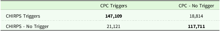
Our analysis of payout determinations in 2021 uncovers aggregate differences as well as similarities across the two input data sources. Although the indices agree in nearly 87% of determinations (calculated as the sum of the total bolded numbers in Table 2 divided by the total number of observations, assessed at a 90% coverage level), this also implies that in $\sim $
13% of cases, CHIRPS and CPC would have made different payout determinations.
$\sim $
13% of cases, CHIRPS and CPC would have made different payout determinations.
Payout determinations for CHIRPS data (CHIRPS)-sized (n = 27,705) grids, using calculated CHIRPS and CPC values across all 11 intervals in 2021, using a 90% coverage level. Bold indicates agreement.

In particular, at the 90% coverage level, the CHIRPS index triggers more frequent payouts in mid-Texas, and the CPC index triggers more frequent payouts in the eastern and western portions of the state (Figure 3). Overall, however, using CPC data and grids appears to trigger payouts more frequently than CHIRPS.
Percent of fine-scale pixels where payouts are triggered solely when using (A) CHIRPS or (B) CPC input datasets. (C) Areas where payout determinations between CHIRPS and CPC disagree (a grid-wise sum of panels (A) and (B)). Payout determinations in all subfigures are based on the 90% coverage level and all 11 intervals in 2021.

Differences in estimated magnitude of payouts
Turning to our evaluation of payouts over time and space, we first compare our estimates using the CPC rainfall index (1981 start year) against the values recorded by USDA (Table 3). Our estimates come especially close (90–103%) starting in 2018, following major updates to county base values.Footnote 11
Estimated payouts, in millions of U.S. dollars, using CPC data (1981 baseline start year) compared with values recorded in USDA’s Summary of Business for the state of Texas (2012–2023).

Second, we consider how our two primary datasets vary in the magnitude of total estimated payouts across all counties in Texas. Using the CPC index amounts to $165.5 million compared to $108.3 million for CHIRPS, yielding a difference of $57.2 million (Table 4).
CPC and Climate Hazards Group InfraRed Precipitation with Station data (CHIRPS) estimated indemnities by coverage level for 2021, in millions of dollars. As the coverage level decreases, the ratio between CHIRPS and CPC indemnities decreases, reflecting a higher relative gap in payouts. Percentages may not total 100% due to rounding.

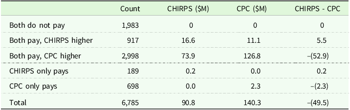
These figures can be broken down further to discern where the major differences arise. First, although both CPC and CHIRPS triggered payouts about as often as one another – i.e., had similar numbers of payout determinations – in 2021 (Table 2), we consistently see higher magnitudes of CPC payouts compared with CHIRPS. Second, the ratio of CHIRPS and CPC payouts diverges most at lower coverage levels, i.e., 70%. Both of these phenomena are due not only to differences in the determination of payouts but also their magnitude, as driven by the Payment Calculation Factor (PCF). As described in the Methods and Data Section, the PCF yields higher payouts for lower rainfall index values, meaning that a precipitation dataset with more extreme low values will yield higher payouts, even if both indices determine a payout is warranted. Examining the empirical cumulative distribution functions for CPC and CHIRPS indices shows that CPC has a larger share of low index values for almost all intervals from 2021 to 2023 (Figure A.5).Footnote 12 Of the $49.5 million higher estimated payments in 2021 for CPC compared to CHIRPS (grazing only), a net $47.4 million of payouts occur when both the corresponding CPC and CHIRPS indices issue payouts (Table 5).
Magnitude of estimated indemnities for CPC and CHIRPS indices (grazing only, 2021). Count refers to unique combinations of county, coverage level, and interval. Totals are the product of these three values since not every county has policies at all coverage levels and intervals.

In 2021, the arid western and northern counties in Texas seem to exhibit the largest differences in payouts (Figure 4). Some of the marked differences between CHIRPS and CPC payouts in those areas could be due to higher enrollment potential in those large counties. However, CPC payout magnitudes generally exceed those of CHIRPS. Several central and southeastern counties show higher CHIRPS payouts, though the differences there are smaller than the totals in the opposite direction where CPC dominates.Footnote 13
(A) Difference and (B) Ratio of estimated county-level payouts for CHIRPS and CPC in 2021. Orange (blue) shades indicate higher (lower) CHIRPS payouts relative to CPC.

Discussion
This study examines how choices about the input data details used for weather-based insurance affect payout determinations in a large and growing insurance program in the United States. We find that coverage intervals spanning the first months of the year (January to April) exhibit the highest intra-grid variation in precipitation (an average coefficient of variation of $\sim $
8%, with a maximum CV of
$\sim $
8%, with a maximum CV of $\sim $
36%) across the state of Texas, though we also find regional differences. The CPC (current, coarser) and CHIRPS (alternative, finer) rainfall indices yield different payout determinations in 13% of cases for 2021, translating to a simulated gap of over $57 million across the state for that year alone. These gaps are most pronounced in the western, arid regions of the state (Figure 4).
$\sim $
36%) across the state of Texas, though we also find regional differences. The CPC (current, coarser) and CHIRPS (alternative, finer) rainfall indices yield different payout determinations in 13% of cases for 2021, translating to a simulated gap of over $57 million across the state for that year alone. These gaps are most pronounced in the western, arid regions of the state (Figure 4).
Although we sought to align our simulations as closely to the USDA payout protocols as possible, the publicly available information resolved at a county-level (rather than grid- or policyholder-level) required us to make several assumptions that may affect the magnitude of this gap. Our simulated payouts using the CPC data range from 83 to 134% of reported payouts for grazing and non-irrigated, non-organic haying over the years 2012–2023, suggesting that our evaluation approximately but imperfectly replicates the magnitude of PRF payouts. The residual gap would be more readily closed with access to (anonymized) policyholder-level features that are critical inputs to the indemnity function but are not publicly available, e.g., areas contained within each grid and policy-level productivity factors.Footnote
14
Furthermore, even if using a higher spatial resolution may more accurately reflect producer conditions compared to coarser estimates, it may not address other sources of basis risk, such as non-linear relationships between indexed weather inputs and forage/rangeland conditions. For example, an interval precipitation of two inches ( $\sim $
51 mm) may have different effects on forage growth if the rainfall occurs at the beginning, the end, or is evenly spread throughout the two-month interval.
$\sim $
51 mm) may have different effects on forage growth if the rainfall occurs at the beginning, the end, or is evenly spread throughout the two-month interval.
Premium rates would also likely change if using an alternative dataset like CHIRPS, which in turn would likely affect enrollment decisions. Updating premiums would require actuarial analysis of the likelihood of payouts and their magnitudes with the new dataset. More specifically, rating for the PRF program has historically involved evaluating the empirical burn rate and then bounding the final rates based on comparing estimates emerging from evaluating lognormal, truncated normal, and a Gram Charlier expansion distribution (Coble et al. Reference Coble, Goodwin, Miller, Rejesus, Harri and Linton2020). Though rerating is a logical extension we would recommend in future work, we do not recalculate premium rates here, as such an analysis extends beyond the scope of this work that instead emphasizes the importance of considering the spatial nature of input dataset choice.Footnote 15 Importantly, recalibrating premiums using the CHIRPS dataset could induce a number of important behavioral changes among farmers. If premiums decrease in some regions due to potential improved spatial accuracy, enrollment could rise. Alternatively, higher premiums in riskier areas might deter participation. If the finer spatial resolution more accurately captures variation in realized losses, payouts would more closely align with those losses and basis risk would be reduced. However, poorly calibrated premiums could incentivize strategic enrollment or suboptimal land use. Farmers may also adjust coverage levels based on affordability or shift to alternative risk management strategies. Overall, each of these responses could alter the program’s risk pool, patterns of geographic participation, and overall financial sustainability, demanding careful evaluation.
Despite these constraints, our analyses contribute to the conversation on program design by identifying intra-grid variation of a magnitude which raises the specter of spatial basis risk to be of concern. Spatial basis risk – whether it reflects a positive or negative mismatch for policyholders – can influence policyholder confidence in the relevance of the program and its ability to serve as a reliable risk management strategy. Localized losses within a grid may go uncompensated, for example, if a large share of the rest of the CPC grid receives higher rainfall, in turn hurting those who are already suffering from adverse weather. On the flip side, if the CPC grid pays out to producers when they are doing well, for example, the (subsidized) program then incurs greater costs to the public, and one could ostensibly use those funds for alternative productive uses. Intra-grid variation can be used to identify where such misrating may likely occur and thus where targeted ground-reference data collection could be especially valuable. Such variation may arise from multiple factors, including topographical features and elevation changes that influence precipitation patterns. Concerns of this type have been raised by prior administrators of the RMA program (Williams and Travis Reference Williams and Travis2019) and warrant further attention to enhance the correspondence between program design and on-the-ground conditions.
Relatedly, crop condition ground-reference data are not available at scale across the U.S. to confidently state which of these two input sources more closely approximates on-the-ground experiences than the other. This is, after all, part of the rationale for index insurance based on proxies – the sheer vastness of the territory in PRF-eligible areas would require immense resources to develop wall-to-wall coverage from ground sensor networks or field visits. While finer-resolution data may always seem preferable, this is not always the case. Models that produce high-resolution estimates of a given on-the-ground phenomenon can sometimes amplify local inaccuracies. This is particularly true in areas with diverse topography or where ground observations – such as those used to calibrate models like CHIRPS – are sparse, unreliable, or unrepresentative. Either way, such an assessment of the relative merits of each input dataset would require some ground-reference data that link estimated precipitation values against realized losses. Currently, such data are scarce and are frequently only possible to obtain in limited circumstances that may themselves reflect highly controlled environments rather than the “in-the-wild” conditions covered by programs like PRF.
However, even without such ground-reference data, mapping differences in payout determinations and magnitudes can help improve the design and performance of index insurance programs like PRF. For example, areas where indicators generate markedly different readings can be targeted for strategic sampling for ground-reference data collection. For example, if two indices produce highly divergent readings, an alternative design could consider drawing in additional factors such as temperature, soil moisture, or composite drought indices (explored in other works including Kellner and Musshoff (Reference Kellner and Musshoff2011), Black et al. (Reference Black, Tarnavsky, Maidment, Greatrex, Mookerjee, Quaife and Brown2016), Williams and Travis (Reference Williams and Travis2019), Vroege et al. (Reference Vroege, Bucheli, Dalhaus, Hirschi and Finger2021), and Tsiboe et al. (Reference Tsiboe, Tack and Yu2023)) to assess deviations from typical growing conditions and provide relief. Generating spatially explicit results can also inform where misrating may be occurring and, thus, where policyholders and the public alike may benefit from re-evaluating how risk is identified and priced.
Overall, this type of analysis contributes to the literature and practice of weather-based insurance design by dissecting the implications of adopting alternative, finer-grained spatial resolution data to trigger payouts. Our particular study setting itself is important, as it reflects a program with increasing enrollment and the potential to address the real threats of erratic or otherwise anomalous weather patterns. As technological and geoprocessing capabilities advance to resolve ever more finely-grained details about the characteristics of the earth, the question of when and how to adopt new input sources that are more spatially (or, in future work, temporally) resolved poses a practical problem and opportunity for program administrators to reckon with. To the extent that using more finely resolved data more closely approximates production losses on the ground, such use could reduce the extent of spatial basis risk and, more generally, warrants further examination for its potential to improve outcomes for policyholders and the public alike.
Supplementary material
The supplementary material for this article can be found at https://doi.org/10.1017/age.2025.10004
Data availability statement
The data that support the findings in this manuscript are freely available at DOI: 10.5281/zenodo.15171495.
Acknowledgements
We appreciate funding support from the Virginia Tech Global Change Center; VT Institute for Society, Culture, and the Environment; the VT College of Agricultural and Life Sciences, and the NASA Harvest Program (Award #80NSSC23M0032). We appreciate the constructive input of Dr. Ed Fox, Mehmet Oguz Yardimci, Jisang Yu, Jennifer Ifft, and other participants of the Kansas State University Agricultural Economics Seminar Series. All errors remain our own
Funding statement
This work was supported by the Virginia Tech College of Agricultural and Life Sciences, the VT Institute on Society, Culture, and the Environment, the VT Global Change Center, and the NASA Harvest Program (#80NSSC23M0032).
Competing interests
The authors declare that they have no competing interests.


 Open access