

INTRODUCTION
Rift Valley fever (RVF) virus was first isolated in Kenya in 1931, almost 20 years after the first RVF-like disease had been documented in the country [Reference Bishop1]. In 1912 and 1913, animal health experts reported an acute and highly fatal disease of lambs on the government farm at the Naivasha area in Rift Valley province in Kenya [Reference Kitchen2]. There were sporadic reports of disease in this same area, usually during rainy seasons until 1931, when a highly contagious epizootic of death in young livestock and abortion in adults was reported in a farm in the same area [Reference Daubney, Hudson and Granham3]. Laboratory workers involved in the investigation also developed an illness, characterized by fever and occasional jaundice [Reference Kitchen2]. RVF virus, a mosquito-borne phlebovirus, was identified as the aetiological agent of this zoonotic disease, which was notable for abortions and perinatal mortalities in livestock, and by acute febrile illness with a range of more severe manifestations including encephalitis, retinitis, and haemorrhage in humans [Reference Bishop1, Reference Daubney, Hudson and Granham3, Reference Meegan, Bailey and Monath4]. Between 1951 and 2007, RVF caused periodic animal and human epidemics in many African countries including Kenya, Somalia, Tanzania, Zimbabwe, South Africa, Egypt, Mauritania, Senegal, and Madagascar and in 2000 in the Middle Eastern countries of Saudi Arabia and Yemen [Reference Meegan5–Reference Abdo-Salem11].
We reviewed records available at the Kenya Department of Veterinary Services in order to chronicle the pattern of the spread of RVF disease across the country after 1912, and identify regions in the country that were vulnerable to periodic epizootics. This study was motivated by two RVF epidemics of 1997–1998, and 2006–2007 in the East Africa region that had similar spatial distribution of animal and human RVF cases in Kenya, Somalia, and Tanzania; with each epizootic starting from the Northeastern province of Kenya between November and December and concluding in the north central region of Tanzania in June of the following year [Reference Woods12–14]. The hypothesis that RVF virus becomes enzootic in certain ecologies has gained broad acceptance, although the ecological and biological factors that might make such geographic areas conducive for virus maintenance have not been fully defined. This has been supported by studies indicating that 1–3% of livestock become infected with RVF in certain ecological zones in Africa during non-epizootic periods [Reference Davies15, Reference Rostal16]. In addition, neutralizing antibodies to RVF virus have been demonstrated in wildlife in Kenya, including African buffalo, black rhino, lesser kudu, impala, African elephant, kongoni, and waterbuck [Reference Evans17], including some born during inter-epizootic periods (IEP) which raises the possibility that wildlife may be reservoirs for the virus during IEP and play a role in amplifying the virus during epizootics. There is a model for forecasting RVF epizootics based on climatic conditions that has recently been successfully applied [Reference Anyamba, Linthicum and Tucker18, Reference Anyamba19]. However, the sensitivity and specificity of the disease forecasts might be improved by determining the role of herd immunity levels and by further characterizing the factors associated with vulnerable ecological zones. Factors that may be associated with vulnerable ecologies may include presence of water-retaining soil types, flat topology that supports flooding, dense bush cover, high Aedes mosquito population, and high livestock populations [Reference Munyua20, Reference Nguku21]. In addition to documenting frequency of RVF epizootics in each district, we correlated this with rainfall patterns in the country in order to provide useful information in guiding veterinary and public health policies on prevention and control of RVF epidemics.
METHODS
RVF epizootics
The annual records of reported livestock diseases in Kenya from 1910 to 2007 from the Department of Veterinary Services at Kabete, Nairobi were reviewed to identify suspected RVF-infected herds in each of the 69 administrative districts. A RVF epizootic was defined as a higher than normal occurrence of abortions or perinatal mortality in livestock (cattle, sheep, goats, camels) herds. As the number and size of districts have recently been restructured, we assigned locality of the epizootics based on the geographic boundaries of the eight provinces and 69 administrative districts in place during 1999 [22]. Administrative districts are the smallest regions with government-stationed officers with responsibility for human and livestock disease management. For the purpose of this report, a national epizootic was defined as a year or group of consecutive years in which RVF livestock outbreaks were documented in at least three of the 69 districts. If RVF was reported in 1–2 districts, we considered it a localized outbreak, and did not include it in the IEP calculations.
Rainfall data
Because heavy rains and flooding have been associated with RVF epizootics [Reference Anyamba, Linthicum and Tucker18, Reference Anyamba19], rainfall data from several sources were collected and average annual rainfall calculated. The Kenya Meteorological Department has compiled national rainfall data since 1890; however, the data compiled prior to 1960 were often incomplete. Rainfall data for the period between 1960 and 1989 was obtained from the website of the International Livestock Research Institute, Nairobi, Kenya [23], while rainfall data for the period between 1990 and 2007 was obtained from the Meteorological Department [24]. We report rainfall data from a representative station in each of the eight provinces between 1960 and 2008. In the six provinces where RVF epizootics were reported, the representative rainfall stations were those closest to the districts reporting RVF; i.e. Nakuru station (Rift Valley province), Garissa station (Northeastern province), Machakos station (Eastern province), Malindi station (Coast province), Thika station (Central province), and Wilson airport station (Nairobi province). For Nyanza and Western provinces where RVF has never been documented, rainfall data were obtained from the Kisumu and Kakamega stations, respectively. The total annual rainfall (in millimetres) from each of the stations was plotted and compared to RVF epizootic timelines to determine the relationship between the two.
Identifying districts vulnerable to RVF epizootics
For each district, we determined the number of national epizootic years during which that district reported RVF cases. To determine vulnerability after introduction of RVF into a district, we examined the proportion (in percent) of national RVF epizootic years that the district was involved in following the initial virus introduction into that district. This was mapped using ArcGIS version 9.2 to generate the density map. Finally, in order to examine the overall relationship between previous epizootics and risk of involvement in subsequent national epizootics, we examined the association between a district being involved in a previous epizootic (either any epizootic or the most recent one) and being involved in the latest epizootic.
RESULTS
RVF activity between 1912 and 1950
Cases of RVF in livestock between 1912 and 1950 were confined to Nakuru district, beginning in Nakuru area in 1912 and spreading to include Naivasha, Marura, Ndabibi, Ol Magogo, and Njoro areas in 1931 and 1936 (Fig. 1). No RVF cases were reported between 1936 and 1950 in the country.
Map of Kenya showing Nakuru district (▪), the only district that reported Rift Valley fever (RVF) cases in livestock between 1912 and 1950. A high number of RVF cases were reported in the district in 1912, 1931, and 1936 involving all divisions within the district.
RVF activity between 1951 and 2007
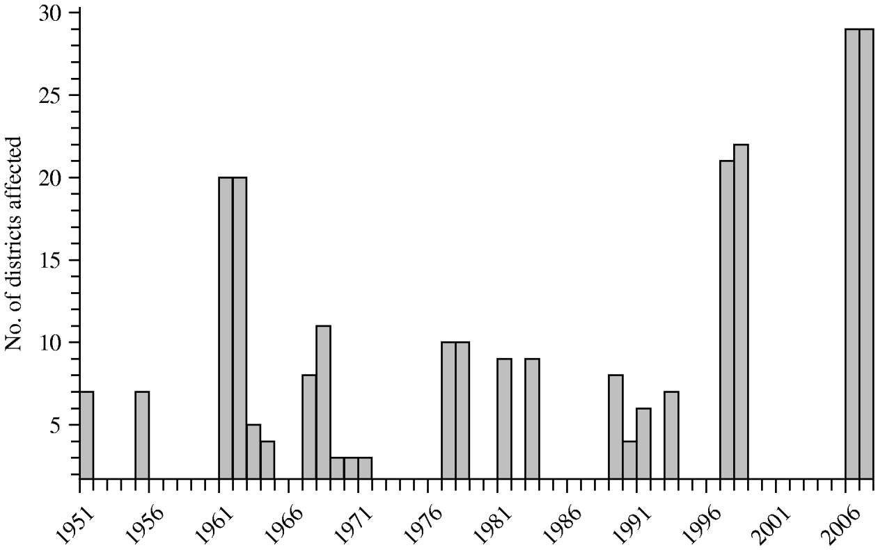
In total, 11 national epizootics occurred between 1951 and 2007 (Fig. 2). The first national RVF epizootic occurred in 1951 and involved 8/69 (12%) administrative districts (Figs 2, 3 a). RVF cases were reported in all five areas of Nakuru district that had reported RVF cases previously, as well as in seven new districts: Trans Nzoia, Uasin Gishu and Laikipia districts in Rift Valley province, Thika, Nyeri and Maragwa districts in Central province, and Nairobi Metropolitan district in Nairobi province (Fig. 3 a). Only one of these newly reporting districts, Laikipia district, borders Nakuru district. Another national epizootic affecting the same eight districts was reported in 1955.
Bar graph showing national epizootics of Rift Valley fever between 1951 and 2007.
Maps of Kenya showing the spatial progression of Rift Valley fever outbreaks by district (![]() ) during the (a) 1951 and 1955 epizootics, and (b) 1964 and 1997–1998 epizootic. (Nyeri district was only involved in the 1997–1998 epizootic). Key for the district numbers: 1, Garissa; 2, Isiolo; 3, Kajiado; 4, Kiambu; 5, Kilifi; 6, Kwale; 7, Laikipia; 8, Machakos; 9, Makueni; 10, Mandera; 11, Maragua; 12, Marsabit; 13, Nairobi; 14, Nakuru; 15, Narok; 16, Nyeri; 17, Tana river; 18, Thika; 19, Trans Nzoia; 20, Uasin Gishu; 21, Wajir; 22, West Pokot.
) during the (a) 1951 and 1955 epizootics, and (b) 1964 and 1997–1998 epizootic. (Nyeri district was only involved in the 1997–1998 epizootic). Key for the district numbers: 1, Garissa; 2, Isiolo; 3, Kajiado; 4, Kiambu; 5, Kilifi; 6, Kwale; 7, Laikipia; 8, Machakos; 9, Makueni; 10, Mandera; 11, Maragua; 12, Marsabit; 13, Nairobi; 14, Nakuru; 15, Narok; 16, Nyeri; 17, Tana river; 18, Thika; 19, Trans Nzoia; 20, Uasin Gishu; 21, Wajir; 22, West Pokot.

Following an outbreak in Nakuru in 1960, sustained national RVF epizootics occurred between 1961 and 1964 (Fig. 2), with disease activity recorded on an almost bi-monthly basis throughout the 4-year period. The epizootic involved 22/69 districts (32%) across six provinces (Fig. 3 b), including all of the districts involved during the 1951 and 1955 epizootics, as well as Narok, Kajiado, and West Pokot districts in Rift Valley province; Garissa, Wajir, and Mandera districts in Northeastern province; Isiolo, Marsabit, Machakos, and Makueni districts in Eastern province; Kwale, Kilifi, and Tana River districts in Coast province; and Kiambu district in Central province.
From 1965 to 1996, national epizootics were reported in 1967–1968 (12 districts); 1970–1971 (three districts), 1977–1978 (11 districts); 1981 (eight districts); 1983 (nine districts); and 1989–1991 (nine districts). Isolated localized outbreaks were reported in 1965 (two districts), 1969 (two districts), 1985–1986 (one district) and in 1987–1988 (one district).
A large epizootic in 1997–1998 involved 22 districts in six provinces. All of the affected districts had previously reported RVF outbreaks; in fact, the epizootic affected 22/27 (81%) districts that had previously reported RVF outbreaks. A cross-sectional survey of farmers and veterinary officials in all the affected districts reported high rates of spontaneous abortions and up to 70% mortality in livestock [14]. The 1999–2005 IEP was relatively quiet, with one district reporting a localized outbreak in 1999 and in 2002. In 2006–2007, the most extensive RVF epizootic involving 33/69 districts was reported [Reference Munyua20]. This epizootic represented the first reported RVF disease activity in 15 districts, including Baringo and Samburu in Rift Valley province; Kirinyaga and Murang'a in Central province; Taita-Taveta, Lamu, and Malindi in Coast province; and Kitui, Meru South, Meru Central, Meru North, Mwingi, Moyale, Embu, and Mbeere in Eastern province. Nine districts that had previously reported RVF outbreaks did not report cases in the 2006–2007 epizootic. It is noteworthy that surveillance was more comprehensive during this epizootic than at any previous time; therefore some of the newly reporting districts may have had scattered low number of RVF cases in livestock that went unrecognized during previous epizootics.
The Western and Nyanza provinces, located on the southwestern region of the country, had never reported human or livestock RVF outbreaks by 2007 even though flooding from the Yala and Nzoia rivers are common in these regions during seasons of heavy rainfall.
IEP
The IEP was defined as the number of years between the end of one national epizootic and the beginning of the next. For the 1951–2007 period, 11 national epizootics spanning 22 years were reported, with an average IEP of 3·6 years (range 1–7 years). However, the IEP within individual districts was longer. For example, for the period between 1912 and 1951 when localized outbreaks were reported in Nakuru district, the average interval between outbreaks was 9 years. In addition, in 19 districts that had reported ⩾3 outbreaks, the average interval between outbreaks was 9 years (range 2–21 years).
Rainfall and RVF epizootics
Annual rainfall measurements from 1960 to 2008 obtained from representative stations in each of the eight provinces are shown in Figure 4 (a, b). The average annual rainfall over the 48-year period was highest in Western (1927 mm), Nyanza (1356 mm) and Coast (1070 mm) provinces, whereas it was lowest in Northeastern (364 mm), Central (844 mm) and Eastern (869 mm) provinces. During this time period, there were seven rainfall seasons when the average rainfall increased by at least 50% compared to the previous year in each of the provinces except Western province. These rainfall seasons were the 1961–1962, 1967–1968, 1977–1978, 1981–1982, 1997–1998, 2001–2002, and 2006–2007 seasons (Fig. 4 a, b). Rainfall patterns in Western province were erratic and not always representative of the national trends (Fig. 4 a). As shown in Figure 4 (a, b) (arrows), there were national RVF epizootics in each of these high-rainfall seasons except in 2001–2002 when only a few cases were reported in Nakuru.
(a) Rainfall curves for the first four provinces, namely Nyanza, Western, Nairobi, and Central provinces of Kenya showing annual total rainfall in millimetres, 1960–2008. The data was taken from the Kisumu station for Nyanza, Kakamega station for Western, Wilson airport station for Nairobi, and Thika station for Central provinces, respectively. (b). Rainfall curves for other four provinces, namely Rift Valley, Northeastern, Eastern, and Coast provinces of Kenya showing annual total rainfall in millimetres, 1960–2008. The data was taken from Nakuru station for Rift Valley, Garissa station for Northeastern, Machakos station for Eastern, and Malindi station for Coast provinces, respectively. The arrows indicate the years when national epizootics were experienced.

Vulnerable districts
Eight districts reported RVF activity during ⩾60% of the national epizootics, and all these districts were part of the first two national epizootics of 1951 and 1955 (Table 1). Eighteen districts that had been involved in up to six national epizootics were first infected during the sustained 1961–1964 epizootic (Table 1, Fig. 5 a).
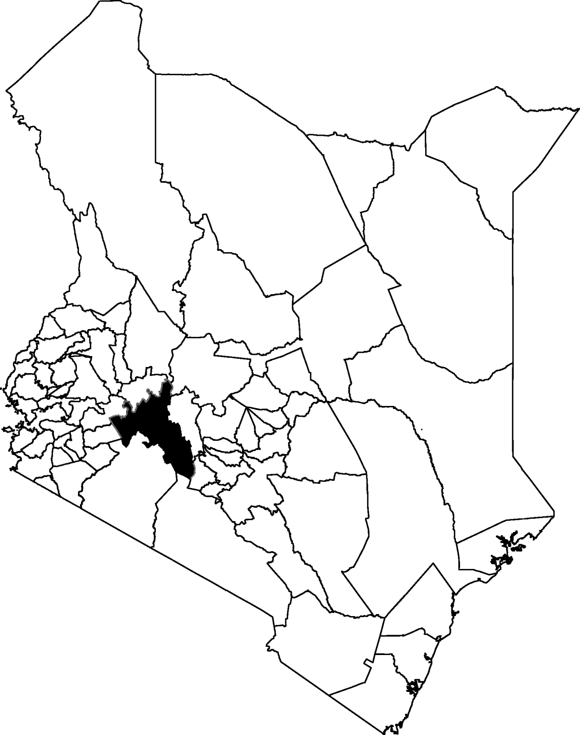
(a) Map of Kenya showing districts that have been most vulnerable to Rift Valley fever (RVF) epizootics. The probability of an outbreak in each district is calculated as the number of years the district reported livestock RVF cases since the year it first reported the disease. (b) Topographical map of Kenya showing elevation. Most RVF cases occurred in low-lying regions, with cases in Northeastern and Coast provinces occurring in areas with an elevation of ⩽1000 ft whereas those in Rift Valley occurred in areas with an elevation between 4000 and 5000 ft.

List of Kenya districts showing the province, the year of first report of Rift Valley fever (RVF), the total number of years national RVF outbreaks have been reported since the year of introduction, the number of years district has been involved in national outbreaks and the proportion of years of involvement in national outbreaks.
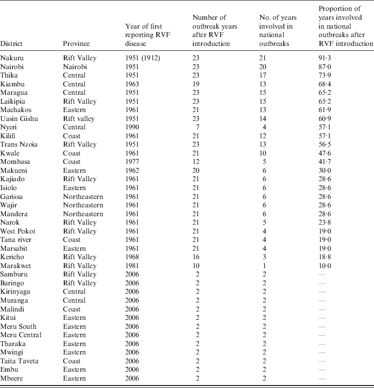
For many districts, disease activity was reported in all years of national epizootics once RVF was introduced. Overall, the probability of a district being involved in a national epizootic was fivefold higher (62%) if the district had previously reported the disease than if the district had no prior disease activity (11%). Similarly, the probability of a district being involved in the next national epizootic was sixfold higher (45%) if it had been involved in the most recent epizootic than if it had not been involved (7%).
DISCUSSION
A growing number of countries in Africa have reported severe epizootics of RVF, resulting in the disease becoming enzootic in at least 12 countries and being serologically documented in 16 more countries [Reference Gerdes6, Reference Zeller7, Reference Madani10, Reference Abdo-Salem11, Reference Elfadil25–Reference Youssef27]. In 2000, a severe epidemic involving humans and livestock occurred in the Middle East, resulting in the virus becoming enzootic in that region [Reference Abdo-Salem11, Reference Elfadil25]. The epizootics in Africa and the Middle East have resulted in death of millions of livestock, and over 2000 human deaths. Experts predict that that the risk of even more severe epizootics in these regions and other parts of the world is increasing, in part, due to changing global weather patterns [Reference Anyamba19]. Although it still requires improvement, the RVF prediction model that is based on global climatic cycles has predicted the location and timing of last few epizootics in Africa about 3 months in advance, and experts believe that appropriate timely response to the warning can prevent, or significantly mitigate the impact of RVF epizootics [Reference Anyamba19]. Effective preventive measures include public education, livestock quarantine, and livestock vaccination targeting vulnerable ecological regions [Reference Anyamba19].
The history of RVF in Kenya presented here suggests that the disease becomes enzootic in some districts, resulting in periodic epizootics associated with activation of virus maintained in these districts (L. Nderitu, unpublished data). For example, the eight districts involved in the epizootics of 1951 and 1955 were subsequently involved in more than two-thirds of all epizootics until 2007. In fact, 10 of the 13 most vulnerable districts with average to high risk of involvement (defined as districts involved in over 40% of subsequent national epizootics) were involved in the 2006–2007 epizootics, whereas only 5/12 districts with moderate likelihood (districts involved in 10–30% of the national epizootics) were involved. Most of the districts with no rating (Table 1) were districts that reported RVF outbreaks for the first time in the 2006–2007 epizootic. Clearly, not all infected districts were involved in subsequent epizootics indicating that other factors are involved in the establishment of an enzootic state in a district. Districts where the virus is enzootic include Nakuru, Nairobi, Thika, Maragua, Laikipia, Uasin Gishu, Trans Nzoia, Kiambu, Machakos, Kilifi, and Kwale, all of which have reported recurrent disease activities in successive RVF epizootics as shown in Figure 5 a. The IEP of 3·6 years between national epizootics even when some IEP years reported heavy rainfall and flooding was probably the time required for herd immunity to fall to levels permissive for the spread of the virus. Analysis of annual rainfall data confirmed the association of epizootics with widespread heavy rainfall and flooding since all national epizootics occurred in years with >700 mm of average annual rainfall in the entire country.
In summary, during the first 38 years after RVF disease was described in Kenya, disease activities were confined to one district in Rift Valley province, in an area prone to flooding and one where livestock were raised in proximity with wildlife. Following the 2006–2007 RVF epizootic, the disease has now been reported in 55% (38/69) of the districts and in six of the eight provinces in the country. The first two national epizootics involving ⩾3 districts were reported in 1951 and 1955. However, the first most extensive and sustained RVF epizootics in Kenya were reported between 1961 and 1964, resulting in spread of the virus in over 55% of the regions known to have the disease today (Fig. 3 b). RVF virus has become enzootic in permissive ecological zones in Kenya since 1964 following widespread epizootics of the disease. Apart from climatic changes resulting in heavy rainfall, other factors associated with vulnerable ecologies may be flat topology that supports water-retaining soil types, dense bush cover, high Aedes mosquito population, and high livestock populations [Reference Munyua20, Reference Nguku21]. A study conducted during the 2006–2007 epidemic showed that a majority of focal human and animal outbreaks occurred in lower altitudes, with most cases in Northeastern and Coast provinces occurring in areas below 1000 ft above sea level, and cases in Rift Valley province occurring in areas between 4000 and 5000 ft above sea level (Fig. 5 b). Sporadic cases identified in the Kenyan highlands were often associated with livestock movement from low-lying areas. In addition, the study found over 72% of human cases occurring in areas with the solonetz, solonchak, or planosol soil types that are known for water retention (A. Hightower, personal communication).
The findings of this study should be interpreted in light of some limitations. First, the passive surveillance data used may represent underreporting of cases, and this may have improved over time. For example in the 2006–2007 epizootic, there was more extensive livestock surveillance than in any previous epizootics, which may have contributed to the documentation of scattered livestock RVF cases in certain districts that would otherwise not have been reported. However, it is important to note that the typical RVF clinical presentation of high numbers of abortions in pregnant animals and mortality of young animals are routinely reported through animal officers who are present at every locality, in compliance with the Kenyan government's notifiable disease policy. Therefore, whereas it was possible to miss an isolated livestock herd infected with RVF in a remote district, it would have been impossible to miss widespread RVF infections in any district. Second, RVF-positive herds were not always confirmed in the laboratory during non-epizootic periods. This may have resulted in overreporting of the number of herds.
DECLARATION OF INTEREST
None.


