


Agricultural land use is an essential component of what makes pedestrian survey in rural landscapes a viable and effective method of archaeological investigation. Planting and plowing churn the soil and bring artifacts to the surface, while field clearing and crop harvesting create areas that are free of vegetation, allowing field teams to observe artifacts on the ground (Ammerman Reference Ammerman1995; Dunnell and Simek Reference Dunnell and Simek1995). As Shott (Reference Shott1995:477) has noted, however, these processes are a “decidedly mixed blessing,” because the same agricultural land-use practices that expose artifacts are also often those that displace, modify, and in some cases destroy archaeological deposits. Evaluating how land use affects archaeological remains, and particularly how it biases or distorts the results and interpretations of archaeological surveys, has therefore long been a topic of investigation and debate (Ammerman Reference Ammerman1985; Dunnell Reference Dunnell1992; Dunnell and Simek Reference Dunnell and Simek1995; Navazo and Díez Reference Navazo and Díez2008; Noble et al. Reference Noble, Lamont and Masson-Maclean2019; O’Neal and Lowery Reference O’Neal and Lowery2017; Palumbo Reference Palumbo2015; Roper Reference Roper1976; Taylor Reference Taylor2000; Yorston et al. Reference Yorston, Gaffney and Reynolds1990).
Investigating the relationship between land use and the archaeological record is challenging, however; it often requires multiple observations of the same area over time, as well as a record of how land-use practices have changed in that area during the same period. The need to maximize time and limited funds often leaves little capacity for any work not directly associated with collecting or studying archaeological materials; in general, the duration of most survey projects leaves little opportunity for monitoring long-term land-use trends (Davis and Sutton Reference Davis and Sutton1995). Moreover, survey projects are usually conducted for one month of the year for only several years in a given region. This can make it difficult to gain an overall impression of land-use practices even when there is sustained and committed engagement with local farmers. These practices encompass not only plowing, planting, and harvesting of different crops but also letting the land lie fallow, using the land as pasture, and other cyclical or periodic changes to how plots of agricultural land are managed. Land holding is also often fragmented and split between multiple communities, and not all farmers are willing to share or be fully transparent about how much land they own or how they have used it. Studying such patterns at a regional scale, but at the resolution of individual fields, is therefore a genuine challenge. Understandably, this type of work is beyond the scope of most archaeological projects that are otherwise focused on studying the patterns of human activity in the past.
For these reasons, examples of archaeological “resurvey”—in which a project will document archaeological remains within the same group of fields several times over some period of time—are comparatively rare within archaeological scholarship and are largely focused on regions around the Mediterranean (Ammerman Reference Ammerman1995; Lloyd and Barker Reference Lloyd, Barker, Barker and Hodges1981; Sánchez et al. Reference Sánchez, Pelgrom and Stek2017; Shott Reference Shott1995; Tartaron Reference Tartaron2003; Waagen Reference Waagen2014). Yet the results of this work are notable, finding changes in the distribution of crop types, land-use intensities, and areas of abandonment, with considerable impact on the reproducibility of survey results (Ammerman et al. Reference Ammerman, Koster and Pfenning2013; Thompson Reference Thompson, Susan and John2004). Research based on resurveying the same area two decades after its initial survey found, for example, that when fields are converted from growing annual to perennial crops, such as grapes or fruit trees, fields undergo highly disruptive processes of deep plowing and churning that can bring large quantities of artifacts to the surface. Yet once planted, these crops require minimal annual maintenance, and so these dense scatters will become significantly less pronounced over many years (Thompson Reference Thompson, Susan and John2004:82–83). These findings strongly support the assertion that a good deal of the archaeological record, as it is documented by pedestrian surveys, is as much a record of modern-day land-use practices as it is a record of the ancient past (Ammerman et al. Reference Ammerman, Koster and Pfenning2013:303).
To encourage further work of this nature and to bridge the divide between the capabilities of most survey projects and the interest in evaluating contemporary land-use trends, we point to recent advances in satellite remote sensing, cloud computing, and publicly available datasets as providing new solutions to facilitate that study. Specifically, we introduce a methodology that draws on the multiyear, publicly available archive of Sentinel-2 10 cm resolution imagery that is hosted on Google Earth Engine’s cloud-based computing platform (Gorelick et al. Reference Gorelick, Hancher, Dixon, Ilyushchenko, Thau and Moore2017; Phiri et al. Reference Phiri, Simwanda, Salekin, Nyirenda, Murayama and Ranagalage2020). Going back as far as 2017, this archive provides near-global coverage with an average revisit time of five days between images, providing sufficiently high spatial and temporal resolution to study contemporary land-use practices. Using these data, we investigate how land-use intensity varies and how it changes over time within a given survey region.
We use the terms “land use” and “land-use intensity” here in deliberate and distinct ways. In general, “land use” refers to the human use of and intervention(s) in a given landscape. Although we are only investigating a particular type of land use—the cultivation of annual crops through practices such as clearing and plowing—we consider it important to nevertheless retain the broader nomenclature. Our reasoning is that all forms of land use, agricultural or otherwise, have relevance for archaeological survey and the developmental histories of the landscapes in which surveys take place. And even though the methodology presented here is calibrated to address one particular kind of land-use change, satellite remote sensing is well equipped to study other land-use and land-cover trends as well, including deforestation and urban sprawl. Similarly, our use of “land-use intensity” refers specifically to the frequency of planting and cultivation across a multiyear period. Yet we acknowledge that even unplanted land is often still being used, whether as pasturage, or for cover crops, or even simply to allow nutrients to replenish in the soil. Our uses of “land use” and “land-use intensity” are therefore applied narrowly but framed broadly in relation to our more general interests in understanding the landscapes in which archaeological surveys are taking place.
Using these data, metrics, and definitions, we address the following three research questions:
1. Q1: How does land use vary within a given study area and why?
2. Q2: Do archaeological surveys preferentially focus on areas with high-intensity land use?
3. Q3: Do areas with high-intensity land use produce higher counts of recovered archaeological materials?
Focusing on land-use patterns in west-central Sardinia (Oristano Province) during the period from 2018 to 2023, we define three categories of land-use intensity based on how many years within that six-year period a given field was used. Then, using intensive archaeological survey data from the Sinis Archaeological Project, we map the distribution of survey tracts recorded since 2018 within the same region. Based on the location of those survey tracts and the quantity of materials recovered from them, relative to the three categories of land-use intensity we define, we address our three research questions and consider what effects land-use intensity may have on archaeological survey. Our results ultimately demonstrate a much more complex and indirect relationship between contemporary land use and archaeological survey than is traditionally assumed and emphasize the value of considering the modern-day contexts in which we conduct fieldwork.
Background
Initiated in 2018, the Sinis Archaeological Project (SAP) is a regional archaeological survey that investigates land use, settlement patterns, and colonial interactions in antiquity in west-central Sardinia (Italy), the largest island in the western Mediterranean (Figure 1). This landscape is ecologically diverse. A plain called the Upper Campidano stretches across the southwestern part of the island, creating an expansive fertile zone suitable for agriculture and pastoralism (Depalmas and Melis Reference Depalmas, Melis, Martini and Chesworth2010:183–184). SAP’s survey Zone A is located in this plain, centered on a Bronze and Iron Age Indigenous site called Nuraghe S’Urachi (Van Dommelen et al. Reference Dommelen, Peter, Gosner, Hayne, Pérez-Jordà, Ramis, Roppa and Stiglitz2018). Directly west is the Sinis Peninsula, an aeolian landscape with seasonal lagoons, sandstone and limestone outcrops, and arable land (Carboni and Lecca Reference Carboni and Lecca1995; Melis et al. Reference Melis, Di Gregorio, Panizza, Soldati and Marchetti2017). SAP’s survey Zone B and D are in the northern and southern parts of this peninsula, respectively. A significant Roman site with Phoenician origins, Tharros, is situated in the southern tip of the Sinis Peninsula near the Cape of San Marco. Within this southern Zone D, paleoenvironmental evidence confirms increased agricultural land use near Tharros from 5400 to 1600 cal BP, coinciding with Indigenous Nuragic, Phoenician, Punic, and Roman cultural phases (Di Rita and Melis Reference Di Rita and Melis2013). Finally, a mountain range called the Montiferru Mountains and its foothills are situated adjacent to the sea and just north of the Upper Campidano region. SAP’s Zone C is in this zone, which is heavily vegetated but is significant for its iron and basalt. This zone also had a Phoenician colony Cornus in the foothills of these mountains near the coast (Blasetti Fantauzzi and De Vincenzo Reference Blasetti Fantauzzi and De Vincenzo2013). Today, much of the survey region is extensively farmed, with fields being used for cereal and tree crops, as well as for animal pasturage. Comparison of historical aerial photography with modern-day satellite imagery taken from part of Zone B shows broadly similar patterns and distributions of land management, a;though with a shift toward larger and more consolidated fields (Figure 2).
Map showing the Upper Campidano, Sinus Peninsula, and Montiferru Mountains in west-central Sardinia and survey areas (Zones A–D) of the Sinis Archaeological Project within this landscape.

Comparison of aerial and satellite imagery from Zone B dated between 1955 and 2025. Aerial imagery provided courtesy of Aerofototeca Nazionale and the Ministero della Cultura. Satellite imagery © Bing Maps.

SAP’s research methodology has allowed the project to investigate not only how these landscapes were used in the past but also how their modern exploitation has affected the archaeological record. We carried out initial exploration and remote sensing in all four zones, with an intensive survey undertaken in Zones A and B, primarily in areas currently used or agriculture or pastoralism. SAP uses a traditional Mediterranean-style methodology for pedestrian survey within each of the four targeted zones of study (Attema et al. Reference Attema, Bintliff, Van Leusen, Bes, De Haas, Donev and Jongman2020:3–4; Knodell et al. Reference Knodell, Wilkinson, Leppard and Orengo2023:266): we systematically explore the landscape with teams of fieldwalkers. Fields are initially identified by observing recent normalized difference vegetation index (NDVI) imagery that indicates they have been plowed or cleared and then verifying their condition on the ground in person (Plekhov et al. Reference Plekhov, Gosner, Smith and Nowlin2020). Fields are then selected for survey if they are accessible and if ground visibility is at or above about 60%, a determination that the survey leader makes in conversation with the team (Gosner and Nowlin Reference Gosner and Nowlin2023:10). Survey units are then delineated based on existing field boundaries or, in the case of larger open terrain, by imposing artificial grids.
Once survey units are mapped, fieldwalkers traverse transects at 10 m spacing, recording and collecting artifacts 1 m in either direction. SAP counts and records all ceramics, lithics, glass, metal, bones, and pieces of modern trash. Diagnostic ceramic sherds and lithics, such as worked obsidian and basalt, glass, and portable metal objects, are collected for analysis. Thus far, ceramic sherds are the most common finds for the surveyed fields in Zones A and B. Of the 4,559 collected diagnostic sherds, 75.5% fall into ancient chronologies and 24.5% are postmedieval to modern in date. These percentages are based on count, rather than weight. Unsurprisingly, ancient ceramics tend to be more fragmentary than those of more recent chronologies because they have spent more time in the plowsoil. It is also true that ancient diagnostic finewares, such as Roman black gloss and red-slipped terra sigillata tableware fragments, are typically small but highly visible to fieldwalkers because of their decoration. This may contribute to higher recovery rates of Roman ceramics than those from earlier periods (see also Gosner and Nowlin Reference Gosner and Nowlin2023:8–11). A majority of the diagnostic ceramics from recent periods are green and yellow glazed wares produced in Oristano and surrounding territories from the medieval period until the 1980s. These include substantial handles, bases, and rims of large vessels for transport, storage, and cooking; preliminary analysis suggests that most date to the nineteenth and twentieth centuries.
Although ongoing analysis shows that most ancient sherds date between about 1000 BC and AD 300, sherds coincident with the Punic and Early Roman occupation of the island are much more commonly recovered and more widespread across Zones A and B. This distribution pattern, which has been observed on other surveys in Italy and other parts of the central Mediterranean, seems to reflect not just the visibility of certain ceramic types of this period but also the phenomenon of “rural infilling” associated with intensifying land use during the second half of the first millennium BC (Bernard et al. Reference Bernard, McConnell, Di Rita, Michelangeli, Magri, Sadori and Masi2023:25–26). About 3,960 lithics have been recovered, the most common (3,706) of which are chipped stone tools and debitage crafted from obsidian. This volcanic glass was available on the island and quarried from Monte Arci to the south of SAP’s survey zone. The lithic chronologies are not yet available for publication.
Most other artifacts recovered date to modern chronologies ranging from the nineteenth century to the present. For instance, all 87 pieces of glass bottle fragments are modern, as are nearly every metal object (30 of the 32); for example, bottle caps, bells, nails, and fragments of farming equipment. The two remaining metal objects are Roman bronze coins, one of which depicts Claudius II Gothicus and therefore dates to his rule from AD 268 to 270. The trash, often fragments of plastic irrigation piping and tarps, sheds light on contemporary agricultural practices. The information recorded about modern trash and land use, such as crop type (e.g., cereals, vines, orchard) and current condition (e.g., plowed, fallow, planted) provides observations about land use at the time of survey. These survey data are a helpful complement to the remote sensing-based evaluation undertaken in the remainder of this article.
Methodology
Data Sources
This study uses satellite imagery collected by the Sentinel-2 mission, operated by the Copernicus Programme of the European Space Agency (Phiri et al. Reference Phiri, Simwanda, Salekin, Nyirenda, Murayama and Ranagalage2020). Operating since 2015, the Sentinel-2 mission currently consists of three individual satellites that are able to collect near-global imagery of land surfaces in 13 spectral bands and at a spatial resolution of 10–60 m. Because the satellites are in sun-synchronous orbits with a consistent offset between them, at least one Sentinel-2 satellite is able to image the same part of the Earth’s surface about every three to five days. The combination of such high temporal, spatial, and spectral resolution; near-global coverage; and free and public accessibility makes the Sentinel-2 mission one of the most commonly used data sources for a wide range of research applications (Opitz and Herrmann Reference Opitz and Herrmann2018:23–24).
The ease of using such data has been enhanced by its inclusion within Google Earth Engine’s Data Catalog (Gorelick et al. Reference Gorelick, Hancher, Dixon, Ilyushchenko, Thau and Moore2017). Google Earth Engine (GEE) is a cloud computing platform that allows users to process and visualize vast datasets of satellite imagery and geospatial data at a speed and scale not normally possible for individual computers (Herndon et al. Reference Herndon, Griffin, Schroder, Murtha, Golden, Contreras and Cherrington2023). Users interact with the platform by writing code in GEE’s JavaScript or Python Application Programming Interfaces (APIs) that subsequently is passed to the servers and runs remotely before the results are returned. GEE is currently free to use for all research and academic applications and has extensive documentation and tutorials available to help new users get started.
This study employs the Harmonized Sentinel-2 MSI: MultiSpectral Instrument, Level-2A (COPERNICUS/S2_SR_HARMONIZED) surface reflectance dataset from the GEE Data Catalog. This dataset covers the period from March 2017 until the present and is provided with numerous quality assurance bands that allow cloud and snow cover to be classified and filtered out. For the purposes of this study, the data were filtered to the period between January 1, 2018, and December 31, 2023, and clipped to the spatial extent of the Province of Oristano, which includes the Upper Campidano within which SAP is currently working. This portion of the analysis was conducted in GEE itself using the JavaScript API. All associated files and scripts are available in our online open-access repository (Plekhov et al. Reference Plekhov, Gosner and Nowlin2025).
For the purposes of comparing land-use intensity to the results of SAP, we employ data pertaining to survey tracts, which includes both their spatial geometry and attributes about the quantity and density of artifacts recovered within each tract. Of the 745 tracts surveyed by SAP thus far, we excluded 85 because these fields, at the time of survey, were being used for the cultivation of perennial crops like grapes or olives. As discussed later, we excluded these fields from this analysis because their annual cultivation does not produce a detectable spectral signature. Our final dataset therefore numbers 660 tracts. Finally, to investigate possible factors for why land-use intensity varies across the study area, we also use geological data compiled as part of the “Carta Geologica di base della Sardegna in scala 1:25.000” project and made available through shapefiles on Sardegna Geoportale. This portion of the analysis was conducted in R (R Core Team 2022) with subsequent visualizations done in QGIS. All associated files and scripts are available in our online open-access repository (Plekhov et al. Reference Plekhov, Gosner and Nowlin2025).
Analysis
The term “land use” refers to a rapid change in land cover from vegetation to bare earth, indicative of crops or other plants being cleared through harvesting, in preparation for new planting, or both Such a change would have unique temporal and spectral characteristics that are unlikely to be produced by non-anthropogenic processes and that is unlikely to be associated with nonagricultural interventions (Bégué et al. Reference Bégué, Arvor, Bellon, Betbeder, de Abelleyra, Ferraz Rodrigo, Lebourgeois, Lelong, Simões and Verón2018; Tong et al. Reference Tong, Brandt, Hiernaux, Herrmann, Tian, Prishchepov and Fensholt2017). That is, changes in land cover from healthy vegetation to sparse vegetation or bare earth may occur as part of seasonal senescence or under conditions of drought but will not fully occur within the span of one week. So, too, other land-cover changes, such as those associated with the expansion of urban, commercial, or industrial land use, may happen rapidly but will not show a transition back to dense and healthy vegetation thereafter. A notable exception is something like wildfire, and indeed our results show a marked “false positive” in the northern portion of the province that is precisely the outcome of the deadly fires that devastated large parts of the region in 2021. Given that these parts of Sardinia (Scarpa et al. Reference Scarpa, Elia, D’Este, Salis, Rodrigues, Arca, Duce, Fiori and Pellizzaro2024), and indeed the broader Mediterranean region, in general, are increasingly prone to wildfire activity, users should be mindful of such false positives when applying this analysis.
Conversely, there are numerous kinds of land-use practices associated with agriculture that would not be detected according to the definition we apply here. Arboriculture and viniculture, for example, do not involve seasonal clearing or plowing events and therefore show no spectral signature of change, except perhaps at the initial time of planting. Likewise, annual cover crops, such as clover, can be left planted for an entire year, which may suggest that the field is fallow when it is in fact being actively managed. Indeed, even fallow fields, which will not show signs of harvest or plowing for multiple years, may be used for pasturage and grazing and would therefore still be serving a productive purpose. For these reasons, we want to be clear that this analysis is not meant to provide a comprehensive assessment of all agricultural activity within our study area; instead, it focuses solely on agricultural activities associated with the kinds of land-use practices (i.e., harvesting and plowing) that have been identified as integral to bringing artifacts to the surface (e.g., Dunnell and Simek Reference Dunnell and Simek1995).
With those caveats, the first stage of the workflow applied here is processing the filtered Sentinel-2 images to, as best as possible, mask out clouds while retaining the greatest number of consecutively collected images. Because this analysis depends on detecting sharp changes in spectral values associated with vegetation to infer land-cover changes associated with crop cultivation, cloud cover undermines such analysis. This is because, when present, clouds are recorded as values that differ starkly from the obscured land cover and may therefore register as significant land-cover changes. The imagery is therefore processed to remove pixels with values above a preset cloud probability threshold, which was set to 50 for this study. This value was selected to provide aggressive filtering, even at the risk of removing pixels potentially unrelated to cloud cover.
Each cloud-masked image is then used to produce a normalized vegetation difference index (NDVI) image. NDVI is a widely employed spectral index that is calculated as the ratio between the difference and sum of the near-infrared and red spectral bands (Huang et al. Reference Huang, Tang, Hupy, Wang and Shao2021). The resulting image will have values that range from −1 to 1, with pixels associated with healthy vegetation having values closer to 1, unhealthy vegetation closer to 0.3, and other land-cover classes closer to 0. These NDVI images are then composited into a single image representing a single week period, taking the median values of all images within that week. We do so as an additional way of filtering out clouds, cloud shadows, and any other distorting artifacts that may create artificially high or low values. Compositing also reduces computation time and standardizes the dataset, because some weeks may have more or fewer available images than others.
The workflow can be adjusted to change the interval over which available images are composited, such as from one week to two weeks, but we advise against increasing the interval too much beyond that when seeking to detect agricultural land use. Fully cleared fields can regrow vegetation remarkably quickly, such that within a three-week period a field could be harvested, replanted, and have its new crop grow back enough that satellite images collected immediately before and after this period would not show any significant change (Figure 3). The speed of such green-up is another reason why the high temporal resolution of Sentinel-2 imagery is essential for these kinds of analyses, as satellite platforms with less frequent revisit times are likely to miss many instances of field clearance.
Top: three Sentinel-2 true-color images showing the speed of green-up of agricultural fields within the Upper Campidano. Bottom: time-series plot showing multiple phases of crop growth and cultivation within the noted field, with date range of images highlighted in yellow.

Figure 3 Long description
The image A showing a satellite map view labeled June 11, 2019. A north arrow is at the lower left. A scale bar labeled 0, 200, 400 m is at the lower left. A rectangular outline marks a field near the center. The image B showing a satellite map view labeled June 18, 2019. A rectangular outline marks a field near the center. The image C showing a satellite map view labeled July 1, 2019. A rectangular outline marks a field near the center. A line graph titled NDVI Time Series. The horizontal axis label is Date. The horizontal axis shows tick labels 01/04, 01/29, 02/23, 03/18, 04/09, 05/02, 05/24, 06/16, 07/11, 08/02, 08/25, 09/16, 10/09, 11/13, 12/08, 12/30. The vertical axis label is NDVI. The vertical axis shows tick labels 0.2, 0.4, 0.6, 0.8. A vertical highlighted band spans around the 06/16 tick. The plotted series is a connected line with circular markers. Values are around 0.7 to 0.8 from 01/04 through late April, with a low point near 01/29 around 0.4. Around 05/02 the line drops to around 0.3 and remains near 0.3 through 05/24. Around 06/16 the line rises to around 0.8, then drops to around 0.3 near 07/11. Between 07/11 and 08/25 the line shows repeated peaks near 0.8 and dips near 0.4. Around 09/16 the line reaches a low point near 0.2, then rises to around 0.8 by 10/09. From 10/09 through 11/13 values stay around 0.8, then decline toward about 0.5 by 12/08 and about 0.45 by 12/30.
Having produced the weekly composite NDVI image for each week within the study period, we iterate across the dataset and calculate the difference in NDVI values for each pixel-pair between consecutive images. At this stage, we seek to identify the spectral signature associated with a rapid transition from dense and healthy vegetation to bare earth. For this study, we have determined that a negative change in NDVI value of at least 0.3 is a consistent threshold for identifying cases of field clearance between weekly composite images. As a further check against false positives, especially those caused by any remaining instances of cloud cover, we also specify that drops in NDVI value of at least 0.3 must not be followed by subsequent increases in NDVI of at least 0.3—as would be the case with bad data. Rather, we seek to identify a sharp drop in NDVI value that is also enduring, being followed by either further decreases in NDVI (such as in cases where crops are harvested but not collected), no changes in NDVI (such as in cases where a field remained cleared after harvesting), or only slight increases in NDVI (such as in cases where new crops have already begun to grow back but have not achieved full green-up).
This analysis is run on the full set of weekly NDVI composites, broken down by individual year. Pixels that satisfy these conditions are coded as 1, whereas all other pixels are left coded as 0. The resulting yearly land-use maps are then summed, producing a final multiyear map of land use with pixels coded according to how many years within the six-year study period showed evidence of land use or, more specificallym those forms of land use that involve plowing and harvesting.
With this final dataset of land-use intensity, we characterize the distribution of land-use intensity within the Province of Oristano by identifying concentrations of fields with values of 5–6, indicating land use almost every year within our six-year study period. We then overlay the tracts surveyed by SAP on top of this land-use intensity map and extract intensity values for each tract. Because our intensity analysis takes place on a per-pixel scale, most tracts will contain pixels of a range of values, reflecting the 10 m resolution of the satellite imagery and the fact that fields may show slightly heterogeneous patterns of vegetation growth and crop cultivation, particularly along their edges. We therefore calculate the modal value of the land-use intensity values to get one value for each tract, producing a distribution of values to evaluate whether SAP’s surveying strategy shows a bias toward lower- or higher-intensity fields. Finally, we test the correlation between the count, density, and weight of artifacts recovered from each tract and the intensity of land use taking place therein to evaluate whether land-use intensity has any effect on artifact recovery rates. For these analyses, we do not distinguish between different classes or chronological groupings of artifacts, because our interest is primarily in aggregate recovery rates.
Results
Q1: How Does Land Use Vary within a Given Study Area, and Why?
Because we intentionally conducted our land-use intensity analysis within a study area considerably larger than the survey extent of SAP, we are able to note more general and regional trends that may provide context to what is happening within the comparatively smaller areas being surveyed. At the scale of the entire Province of Oristano, then, we can immediately note that although agricultural land use is widespread, it is concentrated in the coastal plain around the Gulf of Oristano (Figure 4). In terms of land-use intensity, this pattern is even more pronounced, with agricultural areas showing intensities of five to six years located predominantly within the coastal plain. Within that coastal plain, three clear concentrations can be discerned: (1) the vast extent of agricultural land around Arborea, at the southern end of the province; (2) the band of farmland along the Tirso River, just north of the city of Oristano; and (3) the band of farmland along and just north of the Mannu River, at the north end of the Gulf of Oristano.
Land-use intensity map with pixels coded according to how many years land-use was detected from 2018 to 2023. Three notable concentrations of high-intensity land-use are marked with yellow rectangles.

Figure 4 Long description
The map depicts land-use intensity in the Province of Oristano, Italy, from 2018 to 2023. It uses a gradient to represent years of use, ranging from 1 to 6. High-intensity areas are marked with yellow rectangles. Notable concentrations include Arborea in the south, farmland along the Tirso River north of Oristano and areas north of the Mannu River. The legend indicates intensity levels: 1 to 6 years. The map highlights agricultural land use, particularly in coastal plains and river-adjacent areas. A scale bar shows distances up to 10 kilometers and a north arrow indicates orientation.
Geologically, these areas are classified as litoral, lacustrine, and alluvial sediments that, combined with their proximity to major waterways, make them some of the most productive agricultural land in the province. These are not solely natural phenomena, however. The area around Arborea in particular was inhospitable, malaria-infested marshland until the 1920s when the fascist government under Mussolini drained the marshes and established the modern-day town and comune (Murru Reference Murru2001; Soru Reference Soru2000:20). A combination of natural geology and hydrology and considerable human interventions can therefore explain the distribution of most high-intensity land-use areas today, although smaller pockets of high-intensity use are found scattered across other parts of the province. Given that these smaller concentrations are surrounded by lower-intensity areas (one to two years of land use), we can infer that their relatively more frequent use is due to the resources and motivations of those individual landowners farming those plots, rather than any underlying geological, hydrological, or environmental conditions (Figure 5).
Left: example of high-intensity land-use fields situated among low-intensity land-use fields. Right: true-color satellite imagery of the same area courtesy of Google Map Tile Services.

Figure 5 Long description
The left image is a map showing land-use intensity in Tramatza, Italy, from 2018 to 2023. The legend indicates intensity levels by years of use: 0 (black), 1 (dark blue), 2 (blue), 3 (light blue), 4 (light orange), 5 (orange) and 6 (red). High-intensity areas (5-6 years) are concentrated in the central and eastern parts, while lower intensity (0-2 years) is scattered throughout. A scale bar shows distances of 0 to 1000 meters. The right image is a satellite view of the same area, showing agricultural fields and infrastructure. An inset map highlights the location of Tramatza within the Oristano region of Italy.
Many of the low- (one to two years of land use) and medium-intensity land-use areas (three to four years of land use) are also found with the coastal plain around the Gulf of Oristano, radiating out from and connecting the three high-intensity concentrations discussed earlier. Areas such as the southern Sinis Peninsula, the cape of San Marco on the north side of the Gulf of Oristano, and the inland plain east of the city of Oristano have many such medium-intensity fields, as do areas around the smaller farming towns in the highlands along the eastern edge of the province. These areas cover a wide range of geologies and topographies and seem to be representative of less industrial-scale and more smallholder agriculture than those three concentrations of high-intensity land use.
It should also be noted that our methodology still struggles with false positives arising from persisting clouds and shadows, particularly in more mountainous and rugged areas. For this reason, the resulting land-use maps are less accurate for low-intensity land-use classes, showing large extents of such areas in upland regions where there is no evidence of agriculture. Because these areas are not covered by SAP, these false positives have no bearing on our subsequent results or discussion, but they do affect the overall impression of land use within the Province of Oristano suggested by the land-use map.
Q2: Do Archaeological Surveys Preferentially Focus on Areas with High-Intensity Land Use?
The distribution of land-intensity averages across the 660 surveyed tracts is strongly skewed to the right, indicating that SAP has thus far surveyed mostly low-intensity agricultural areas (Figure 6). Across the dataset, the average modal land-use intensity value is 2.06, with only 26 survey tracts (3.9%) having a modal intensity value of 5 or 6. These high-intensity tracts, many of which are subdivisions of larger fields, are mostly found in areas outside the high-intensity land-use concentrations characterized earlier for the Province of Oristano. Instead, these tracts are found scattered among medium-intensity fields within survey zones A and B, underscoring again the impact of individual landowner practices on land-use intensity. That these fields were surveyed alongside those with medium- and low-intensity land-use values also suggests that there was no apparent bias or selection toward them at the time of survey, beyond their availability and current state of cultivation.
Land-use intensity in the Upper Campidano with SAP survey tracts overlain in yellow. On right, barplot shows distribution of modal land-use intensities for survey tracts.

Figure 6 Long description
The map displays land-use intensity in the Upper Campidano region from 2018 to 2023. The legend indicates intensity levels from 1 to 6, with 1 being the lowest and 6 the highest. Areas with higher intensity (5 and 6) are marked in red and orange, scattered among medium-intensity fields. Lower intensity areas (1 and 2) dominate the map, shown in blue shades. Yellow areas represent survey tracts. The bar plot on the right shows the distribution of modal land-use intensity values, with the x-axis labeled ′Frequency′ and the y-axis labeled ′Years of Land-use′. The plot indicates a skew towards lower intensity values, with the highest frequency in category 2, followed by 1, 3, 4, 5 and 6. The scale bar at the top left indicates a distance of 2 kilometers.
On the other end of the spectrum, 103 (15.6%) fields had a modal land-use intensity of 0, indicating that no evidence of cultivation was detected for these fields in the past six years. Because this methodology struggles with small fields where the 10 m resolution of the imagery can result in more pixels corresponding to the borders of the field than its interior, we also conducted spot checks of a sample of these fields to confirm their classification. These spot checks were based on a closer examination of the remotely sensed imagery and confirmed the classification of these fields as having no discernible cultivation within the past six years. These fields seem to be kept in a persistently cleared and unplanted state and, in many cases, are visually indistinguishable from adjacent, more actively used fields.
There are 313 (47.4%) tracts in the low-intensity category (modal intensity of 1 or 2) and 218 (33%) are in the medium-intensity category (modal intensity of 3 or 4). Together, these two categories represent more than three-quarters of the entire dataset, clearly refuting the common assumption that survey teams preferentially survey high-intensity fields.
Q3: Do Areas with High-Intensity Land Use Produce Higher Counts or Weights of Recovered Archaeological Materials?
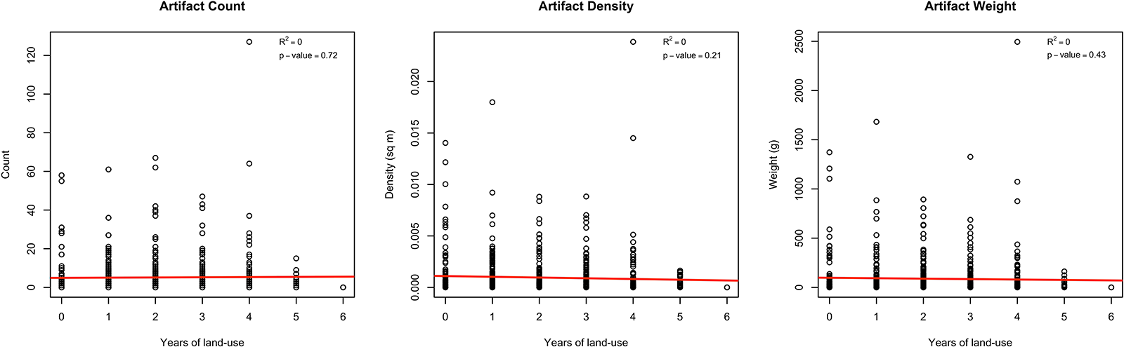
Plotting ceramic counts, densities, and weights against the average modal land-use intensities of their respective tracts shows no relationship between these variables, with an R2 of 0 for each and no statistically significant correlation (Figure 7). These graphs show that, regardless of how we measure artifact frequency, fields with low-, medium-, and high-intensity values have comparable recovery rates. Although the lack of a strong correlation is not surprising, given that archaeological materials are not homogeneously distributed and may, in fact, just be absent from certain areas, the lack of any correlation at all is striking. Indeed, the fields with the five highest densities of materials per square meter have land-use intensity values that range from 0 to 4, with the field with the highest density having a modal land-use intensity value of 0. Although the “real” distribution and quantity of subsurface archaeological materials can never be known, these results suggest that land-use intensity has no discernible effect on the quantity of materials recovered.
Scatterplots showing relationship between land-use intensity and artifact count, density, and weight.

Figure 7 Long description
The first scatter plot shows artifact count against years of land-use. The horizontal axis represents years of land-use from 0 to 6 and the vertical axis represents count from 0 to 120. The plot shows no correlation, with an R squared of 0 and a p-value of 0.72. Data points are scattered with no clear pattern and a red reference line is present at the bottom. The second scatter plot displays artifact density against years of land-use. The horizontal axis represents years of land-use from 0 to 6 and the vertical axis represents density in square meters from 0 to 0.020. There is no correlation, with an R squared of 0 and a p-value of 0.21. Data points are dispersed without a discernible trend and a red reference line is visible. The third scatter plot illustrates artifact weight against years of land-use. The horizontal axis represents years of land-use from 0 to 6 and the vertical axis represents weight in grams from 0 to 2500. The plot indicates no correlation, with an R squared of 0 and a p-value of 0.43. Data points are scattered and a red reference line is shown. Across all plots, data points are evenly distributed with no significant clustering or outliers.
Discussion and Conclusions
A central argument of this study has been that archaeological survey projects working in agricultural landscapes should devote more attention to understanding contemporary land-use practices. From the perspective of survey methodology, studying contemporary land-use practices can help identify and evaluate potential sources of bias in where surveys are being conducted and what effect land-use intensity has on recovered archaeological materials. More broadly, patterns of contemporary land use can reveal underlying environmental processes that may be analogous to those in the past or, conversely, be the result of wholly modern developments. By better situating archaeological surveys within their contemporary contexts, new insights and interpretations can be generated that can help us better understand both the past and present.
Such new insights and interpretations can be seen in our evaluation of archaeological survey work conducted by SAP within the Province of Oristano. Our land-use intensity characterization of this region has shown that recently reclaimed marshlands are the most intensively used farmland areas today—a pattern that would certainly not have been the case in the past. Other high-intensity areas include river floodplains, which were likely targeted for use in the past, but are also prone to meandering, flooding, and significant sediment deposition. The result is that these contemporary high-intensity land-use areas are, counterintuitively, some of the least promising areas for archaeological survey, despite the frequency with which they are plowed and cultivated. Our characterization has also shown that such high-intensity farmland areas are uncommon: very few areas outside reclaimed marshlands and river floodplains are cultivated annually. Rather, many fields seem to show cultivation somewhere between one to four years within the past six-year period. In this regard, the areas surveyed by SAP are representative of the broader region, with about 75% of surveyed tracts having modal intensity values in that range. This is reassuring and indicates that, when scouting fields that are suitable for survey, field teams are not unintentionally prioritizing only high-intensity areas but instead are sampling a representative distribution of fields.
As for the quantity of archaeological materials recovered, our results also indicate that there is no correlation between how frequently a field is plowed and cultivated and the quantity of materials visible on the surface. The essential caveat to this conclusion is that it may well be the case that this region simply does not have extensive distributions of archaeological material at all or that such distributions are evenly spread. It is also possible, given the long history of agriculture in this region, that plowzone assemblages have been so thoroughly depleted and degraded that differences in contemporary practices no longer have bearing on interfield recovery rates (O’Neal and Lowery Reference O’Neal and Lowery2017). A notable limitation of this study is that our survey data begin in 2018 and do not include any new fields that were not intensively plowed for decades. Similar analyses conducted on other regions may produce different results, and it is our hope that work of this kind will be applied to other regions with varying agricultural regimes, histories of land use, and environmental characteristics. However, in the surveyed areas of the Province of Oristano, dense concentrations of subsurface artifacts seem to be localized in only certain areas and are recoverable in quantities that have little relation to how intensely the land above them is being cultivated. Although future survey work will further clarify the extent of ancient activities in this region, we have little reason now to question whether our assemblages are being artificially inflated or deflated by the frequency with which fields are being cultivated.
Based on these analyses, we are thus able to provide several takeaways relevant for survey methodology and practice in such agricultural landscapes. First, we emphasize, as always, the importance of understanding the history of the environments in which survey projects are being planned. Reclaimed marshland does not generally fall within any of our survey zones, and although we were familiar with the history of the reclamation projects in this region, we had not appreciated just how markedly it influenced disparities in land-use intensity. Our analyses presented here have increased our awareness of these areas and made us more attentive to what fields we are selecting for survey and how we are interpreting the quantity of finds from them. We have also developed a stronger interest in surveying low- and medium-intensity fields, which in many cases may not have as clear visibility as high-intensity fields. Despite these potential reductions in visibility, such low- and medium-intensity fields may in fact have longer histories of use than high-intensity fields, though not necessarily more artifacts. Moreover, although our survey forms included spaces to record the types of crops being grown in surveyed tracts, fields not under cultivation would be recorded simply as “fallow.” We now consider it useful to also record whether such fields show evidence of pasturage, cover crops, or other uses that may refine our description of fields as fallow. Such information will provide a useful starting point for any future ethnographic work, particularly that concerned with understanding why farmers may keep their land fallow, for how long, and in what ways. Altogether, these takeaways are not explicit recommendations for changes in survey design but rather examples of how field-based observations can be complemented by remote sensing.
More broadly, this work connects with the long-standing interest within landscape archaeology in understanding changing land-use patterns through time (Casana and McLeester Reference Casana and McLeester2024). Although the archive of available satellite and aerial imagery only goes as far back as the twentieth century (Casana Reference Casana2020; Hammer and Ur Reference Hammer and Jason2019; Hammer et al. Reference Hammer, FitzPatrick and Jason2022; McLeester and Casana Reference McLeester and Casana2021), these resources are nevertheless valuable in providing more than a century of data from which processes of land-use expansion, abandonment, and transformation can be studied. Although the circumstances driving particular twentieth-century changes in land use (e.g., the collapse of the Soviet Union in Eastern Europe and Central Asia) necessarily differ from those in the ancient past, these are nevertheless ecologically and behaviorally analogous processes that can provide great insights into the motivations, constraints, and strategies of ancient farmers in the past in all regions of the world (Alcantara et al. Reference Alcantara, Kuemmerle, Baumann, Bragina, Griffiths, Hostert and Knorn2013; Dara et al. Reference Dara, Baumann, Kuemmerle, Pflugmacher, Rabe, Griffiths, Hölzel, Kamp, Freitag and Hostert2018; Yin et al. Reference Yin, Prishchepov, Kuemmerle, Bleyhl, Buchner and Radeloff2018). Critically, a focus on process and analogy can help fill in the gaps at the limits of studies of ancient land-use practices that focus on relict agricultural features. These features, such as terraces, irrigation systems, and field boundaries, are increasingly disappearing in the face of mechanized agriculture, urban sprawl, and other forms of development (Casana and McLeester Reference Casana and McLeester2024:7). In studying how farmers make decisions today in response to environmental, sociopolitical, and climatic changes, we may be able to model similar decision-making strategies in the past and test how archaeological data support or deviate from those expectations (Bauer Reference Bauer2024; Howey et al. Reference Howey, Palace, McMichael and Braswell2014). We note, for example, that the COVID-19 pandemic took place within the time period of our analysis, and one fruitful avenue for further research would be to investigate how land-use patterns changed during and since that event (see Chavez et al. Reference Chavez, Veneros, Rojas-Briceño, Oliva-Cruz, Guadalupe and García2024; Nolte et al. Reference Nolte, Sipangule and Wendt2022).
The potential of these analyses therefore extends considerably beyond that of evaluating survey methodology. One of the merits of the methodology presented here is that it is fully unsupervised, requiring essentially no input from the user beyond specifying the study area and specifying the threshold for detecting land use. That the resulting land-use map clearly distinguishes field boundaries, despite having no inputs associated with land-use classes or parcel boundaries, demonstrates the effectiveness of this methodology for detecting agricultural land uses, as well as for other possible studies of contemporary farming practices. With minor modifications, this methodology can be adapted to, for example, track regional trends in fallowing practices and looking at how long fields are left unplanted (that is, the opposite of land-use intensity). The methodology can likewise be applied to nonagricultural questions, investigating trends in urban growth/contraction, the location and prevalence of landslide or forest fires, changes in shorelines and riverbanks, and so on. As discussed earlier, retaining a broader focus on “land use” underscores that any detectable changes in land cover can be investigated through the processing of high temporal and spatial resolution satellite imagery, and that such changes often will have relevance for archaeological practice, the monitoring of cultural heritage, or both. In this way, this methodology contributes to the growing body of scholarship that increasingly draws on the vast archives of available satellite imagery and the considerable computational power of cloud-based platforms like GEE to approach archaeological questions in new ways (Herndon et al. Reference Herndon, Griffin, Schroder, Murtha, Golden, Contreras and Cherrington2023; Lasaponara et al. Reference Lasaponara, Abate and Masini2022; Liss et al. Reference Liss, Howland and Levy2017).
We can, for example, envision land-use intensity analyses playing a greater role in monitoring risks to cultural heritage, both for known sites (Conesa et al. Reference Conesa, Orengo, Lobo and Petrie2022) and as part of pre-field or desk-based assessments. Understanding where land-use intensity is increasing or decreasing can contribute to more targeted and timely surveys to detect and record cultural resources and better understand the risk factors potentially affecting them. Indeed, the increasing accessibility of these tools and datasets should allow archaeological projects—both academic and commercial—to incorporate more ecological questions into their research designs, particularly as they relate to recent histories of land-use and land-cover changes. Whereas long-term longitudinal studies had previously been the only way to address such issues (e.g., Ammerman et al. Reference Ammerman, Koster and Pfenning2013), it is now increasingly possible to study land-use dynamics remotely, quickly, and at scales previously impractical. Although such analyses cannot and should not replace fieldwork and engaged conversations with local communities, these datasets have great potential for providing new insights into the formation and structure of the archaeological record and how land use today compares to that from the past.
Acknowledgments
We thank Maura Vargiu and Alessandro Usai of the Soprintendenza archeologia, belle arti e paesaggio per la città metropolitana di Cagliari e le province di Oristano e sud Sardegna for permission to carry out this research. We are grateful to the Museo Civico di San Vero Milis for laboratory space and equipment. We also thank all participants, students, and collaborators on the Sinis Archaeological Project, including Jacob Argo, Katie Breyer, Tarynn Callier, Joseph Carrino, Alex Claman, Clara-Maria Hansen, Kelsey Kistner, Tom Maltas, Catalina Mas, Kell Miklas, Josiah Olah, Seth Price, James Prosser, Alexander Smith, Anna Soifer, and Francesco Quondam. Peter van Dommelen and four anonymous reviewers provided helpful comments that improved the final manuscript.
Funding Statement
The Sinis Archaeological Project has been supported by the Loeb Classical Library Foundation, the European Research Council under Consolidator Grant ERC-2019-COG 865644 for the Migration and the Making of the Ancient Greek World Project (University of Vienna), the Rust Family Foundation under grant RFF-2018-54, the Curtiss T. Brennan and Mary G. Brennan Foundation, the Julia Herzig Desnick Endowment Fund of the Archaeological Institute of America, the DigitalGlobe Foundation, and Texas Tech University.
Data Availability Statement
Data pertaining to Sinis Archaeological Project survey tracts, as well as the scripts and data files needed to replicate the analysis and figures shown here, can be found at https://osf.io/wqyar/. Data on the archaeological materials from the project that are still under study are available upon reasonable request.
Reproducibility Statement
Associate Editor for Reproducibility Ben Marwick downloaded all materials and could reproduce the results presented by the authors.
Competing Interests
The authors declare none.


 Open access