Introduction
Satellite image showing the geographical position of the Mehran Plain in western Iran and the location of Fasil and Choga Khulaman.

The transition to the Neolithic is characterised by changes in subsistence behaviour, as well as other social, technological and economic factors (Reference Bar-yosefBar-Yosef 1998: 143). These changes occurred at sites across the Near East during the ninth millennium BC. Nevertheless, it should be noted that evidence for the Neolithic is far from even. Iran in particular suffers from a paucity of evidence, with little relevant excavation work being carried out within the last few decades. Other regions of the Near East, such as the Levant (Moore 1982; Reference Bar-yosefBar-Yosef 1998), Anatolia (Özdogan & Basgelen 1999) and Northern Mesopotamia (Reference BraidwoodBraidwood 1960; Braidwood et al. 1983; Reference KozlowskiKozlowski 2002) are at present much better documented by comparison.
Research targeted at understanding the Neolithic in western Iran was first conducted by R. Braidwood in the Central Zagros, whose aim was to study the origin of domestication (Braidwood et al. 1961). He carried out excavations at the sites of Sarab and Asiab near Kermanshah, although these were only partially published. Other important excavated Neolithic sites in the Central Zagros such as Ganj Dareh (Smith 1976) and Guran (Reference MortensenMortensen 1975) were also not fully published. Excavation results from other regions such as the Deh Luran Plain (Hole et al. 1969, 1977; Neely & Reference WrightWright 1994), the Susiana Plain (Delougaz & Kantor 1996; Reference AlizadehAlizadeh 2003), the Central Plateau (Reference FazeliFazeli 2001, 2007; Fazeli et al. 2002) and the Southern Zagros (Potts & Roustae 2006) have, however, been more fully published.
The Mehran Plain, located in western Iran (Figure1), is potentially a key region for shedding light on the early Neolithic. So far, two Neolithic sites situated in the northern and eastern parts of the plain have been identified. The following describes these two sites, Fasil and Choga Khulaman, and discusses their importance in the context of future research on the Neolithic.
Fasil
The site of Fasil (N 32° 53' 327" and E 46° 45' 314") is located in the area of the same name, along the 55km road stretching between the Mehran and Deh Luran plains. This runs along a corridor less than 1km in width which links the two plains. The region is characterised by dry, hot summers and mild winters (see Hole et al. 1969: 19-22 for a description of a similar environment).
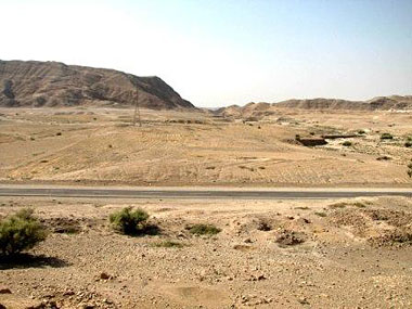
General view of Fasil, looking south-east.

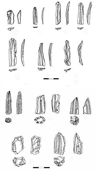
Surface flint tools (top) and various cores (bottom) from Fasil. Scale = cm.

The archaeological remains are spread over 3ha at an elevation of 300m above sea level (Figure 2). The site is situated within easy reach of a range of micro-environments including Kalviz Mountain, a chain of the Zagros about 1km to the north, Gebel Hamrin, about 500m to the south, and lowlands located to the west and the east. There are two seasonal watercourses around the site which spring from the Zagros Mountains and flow to the Hamrin. It is likely that these micro-environments played an important role in the formation of the site, enabling its occupants to access a variety of local resources. Unfortunately the site has been partially destroyed by road construction and cultivation, and plans are now afoot to widen the road which will lead to yet further destruction.
Recent work by the authors at Fasil revealed large numbers of flint and chert tools, including flakes, retouched blades and bladelets (Figure 3), as well as flint cores, including bullet-shaped cores and blade cores, on the surface. Of potential significance was the absence of Neolithic pottery, although lack of preservation may have been a contributing factor.
Notably, stone objects such as flat-topped boulder grinding slabs, shallow basin grinding slabs and mortars were prominent surface artefacts. All of the stone objects were made of limestone which is available nearby. Scattered river pebbles found all over the site are suggestive of solid architecture and in some areas stone foundations are visible. Other finds included Chalcolithic potsherds, and part of a baked-clay sickle.
Choga Khulaman
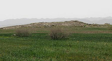
General view of Choga Khulaman, looking south-west.

The site of Choga Khulaman (N 33° 22' 39" and E 46° 16' 16") lies at an elevation of 479m above sea level and is located on the Amir Abad Plain about 10km to the north of Mehran town and 0.4km to the south-east of Golan village. The mound rises to a height of about 5m and is surrounded by cultivated fields (Figure 4).
Choga Khulaman was first discovered during preliminary research for dam construction in 1991. It was subsequently surveyed by the late A.M. Khalilian in 1996 (Reference KhalilianKhalilian 1999) and further delimitated by G. Nokandeh in 1999 who made a number of soundings across the site (Reference NokandehNokandeh 2002).
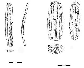
During a short survey of the site carried out in the summer of 2007, a large number of chipped stone and stone objects were recorded. The chipped stone industry included various blade cores, blades, bladelets and debris indicating that tools were being made on-site using reduction, with an emphasis on the use of the pressure technique (Figure 5). Mortars, ground stones, pounders and pestles were the most prominent surface materials (Figure 6). A short survey around the site revealed a chert outcrop to the north which could have been used as raw material for tool production (Figure 7).
Sickle blade (left) and surface blade core (right) from Choga Khulaman. Scale = cm.

A surface ground stone from Choga Khulaman.

Chert outcrop near Choga Khulaman.

The most notable finds from Nokandeh's soundings included an animal figurine, stone ornaments and some historic sherds (Reference NokandehNokandeh 2002).
Unfortunately, despite work carried out at the site to date, destruction caused by both cultivation and illegal digging has continued.
Discussion
The surface data from Fasil suggests that there may have been a long gap in occupation at the site. On the one hand, the chipped stone industry, notably bullet-shaped cores, struck around their entire perimeter using the pressure technique, resemble material from lowland PPN sites such as Ali Kosh (Hole et al. 1969), Chogha Sefid (Reference HoleHole 1977) and Chogha Bonut (Reference AlizadehAlizadeh 2003). The most convincing evidence of a PPN date is the presence of numerous bullet cores whose final products were micro-blades (Reference HoleHole 1994: 107). Thus Fasil may well be as early as the Ali Kosh phase on the Deh Luran Plain.
On the other hand the potsherd and baked clay sickle indicate the presence of fifth-millennium BC occupation. Potsherds painted with horizontal black bands on buff, or vertical red bands on red, resemble those of the Mehmeh Phase (4800-4600 BC) in the Deh Luran Plain and Middle Susiana in the Susa Plain (Hole et al. 1969; Delougaz & Kantor 1996). Baked-clay sickles are first found in the Ubaid 3 in Southern Mesopotamia and are characteristic of this period (Reference PollockPollock 1999: 85). Considering the area's favourable climatic conditions in winter and the lack of cultural deposition, it is possible that Fasil was occupied as a seasonal pastoralist camp sometime during the mid-seventh millennium BC. It is worth noting that the region today is occupied by pastoralists every winter. This hypothesis is in keeping with Hole's contention that pastoralists moved between highlands and lowlands around 6500 BC (Reference HoleHole 1999: 25). If the dating of Fasil to the mid-seventh millennium is correct, it would pre-date Sarab and Tula'i, - thought to be seasonal camps of transhumant pastoralists in the highlands and lowlands respectively (Hole 1987). Analysis of the chipped stone industry may provide some clue as to the subsistence strategies of the site's occupants. One would expect tools such as sickle blades to be far less common in a pastoralist settlement than e.g. scrapers, for example.
At present, our main evidence from Choga Khulaman is comprised of chipped stone and ground stone objects. The chipped stone can be divided into tools and debitage. Tools might consist of retouched blades, bladelets and scrapers, for example, whilst debitage includes various cores, debris, flakes and unused blades or bladelets. Due to high use and continual rejuvenation of the striking platform, some cores have been shortened. The tools are made of flint and chert as well as obsidian, although further analysis will have to await more detailed examination of the proportions of the various lithic types.
Ground stone objects are another prominent surface find and are distributed over the entire site. Since grinding stones are not very portable, their presence is suggestive of sedentary occupation. Indeed, their predomination coincides with the emergence of sedentism in the early Natufian period (Reference WrightWright 1994: 238). According to Kozlowski, mortars can be an indicator of the Neolithic (Reference KozlowskiKozlowski 2002: 72). At Choga Khulaman they were made primarily of limestone. Their use may suggest a shift in emphasis to the use of plants as the main food resource during this period. Furthermore, this apparent change in subsistence coincides with climatic change, namely the dry, cold Younger Dryas. This might explain the increased frequency of ground stone objects found at sites dating to the PPNA, as well as changes in settlement patterns characterised by an extension of settlement into more marginal steppe and desert areas (Reference KozlowskiKozlowski 2002: 258). It has been argued that many sites dating to the transition from Epipalaeolithic to Neolithic are located in steppe-like environments and are characterised by numerous ground stones for food processing (Savard et al. 2006: 183). The geographical position of Choga Khulama, situated as it is in the flanks of the steppe, and the large number of ground stone objects found on the surface similar to the PPNA sites of the Levant, might be important indicators in the relative chronology of the site. At present it is difficult to say whether the site belongs to the pre-agricultural sedentary horizon or that of early farming societies. However, studies at Choga Khulaman so far suggest it is potentially a key site in the study of the Neolithisation process in the Mehran Plain.
Geographically located between the lowlands and highlands, research in the Mehran Plain is critical to understanding interaction between Neolithic communities in both areas. Chronologically, some upland sites are older than those that have been investigated on the Susiana and the Deh Luran plains. Alizadeh (2001: 220) has suggested that, since the Mehran Plain is nearer to the highlands than the Susiana Plain, it may have been occupied by early Neolithic societies before Susiana and even the Deh Luran.
A long gap between the late Epipalaeolithic and the earliest Neolithic sites of highlands, such as Ganj Dareh, is apparent. The most probable reason for this seems to be the effect of the Younger Dryas on the settlement dynamics in the highlands and lowlands. The highlands would have been subject to a much colder, dryer climate at this time, whereas the warmer and wetter lowlands such as Mehran Plain would have provided a much more attractive environment to early Neolithic populations (Reference AlizadehAlizadeh 2001: 220).
Prospects
Although it is thought that the Neolithic revolution began later in Iran than elsewhere (Hole 1991: 20), it could be argued that this view derives primarily from the paucity of transitional Neolithic research in Iran compared with Iraq, Turkey and the Levant.
Archaeological research targeting key sites in Iran, such as those discussed here, is therefore a priority if the Neolithisation process in Iran is to be better understood. Due to the various factors such as alluviation and lack of intensive systematic survey, sites which could shed light on the transitional Neolithic in Iran, similar to sites found in the Levant, have not yet been investigated. Thus it is not presently possible to compare Neolithisation in different parts of Iran. If the Younger Dryas was responsible for the perceived shift in settlement from the highlands to the lowlands, early Neolithic sites such as Choga Khulaman may potentially be highly rewarding in better understanding this period. To test the above hypotheses, notably the importance of the Mehran Plain during the transitional Neolithic period as an interaction zone between Neolithic societies of the highlands and lowlands, the site of Choga Khulaman needs to be excavated. Finally, 'site catchment analysis', based on the exploitation of various natural resources around the site to predict settlement patterns (Tiffany & Abbott 1982: 313), strongly suggests that the northern steppe flanks of the Mehran Plain would have provided a highly favourable position for the formation of the early Neolithic sites. Intensive survey of this area would therefore be potentially very informative.
Acknowledgements
We are grateful to Prof. R. Coningham and Prof. F. Hole for their helpful suggestions as well as H. Taylor who edited the text. We would also like to thank A. Janvanmardzadeh who discovered the site of Fasil and G. Nokandeh for his permission to use the unpublished report of Choga Khulaman.